airborne wide area general assessment of the … · airborne wide area general assessment of the...
TRANSCRIPT

Airborne wide area general assessment
of the environment pollution due to exploded ammunition storage
Milan BajićPh.D. Scientific Council HCR Center for Testing,
Development, Training Ltd., Zagreb, Croatia,
E-mail: [email protected]. ++38598460917
Skype: milan.bajic.zgb
IARP Workshop, TIRAMISU, Šibenik, Croatia, 24.04.2012
Before explosion After explosion
Introduction
Event driven initiative
The ammunition storage Padjene (Croatia) exploded 13.09.2011., the cause was the wild forest fire. The Commander of Croatian Air Force and Air Defence suggested to apply hyper spectral and multisensor imaging the ammunition storage Padjene, by the airborne multisensor system, [1], [2].
13.10.2011 was derived first concept of the dedicated research project.
Goal:
develop, test, evaluate and operationally validate technology for the airborne hyper spectral & high spatial resolution multisensor assessment of the UXO litter at and around ammunition storage after undesired explosion, spectrally matched to UXOs and their litter, crude missile fuel and their litter at the considered terrain, soil and vegetation.
Objectives:
Detect and locate UXO litter, produce thematic raster maps of UXO, their parts, in selected regions inside circular area centered at the ammunition storage Padjene.
Assess the initial chemical contamination by airborne hyper spectral imaging of the ammunition storage Padjene after the undesired explosion.
2IARP Workshop, TIRAMISU, Šibenik,
Croatia, 24.04.2012
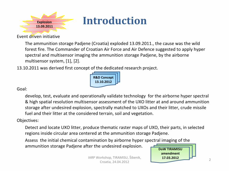
Explosion
13.09.2011
R&D Concept
13.10.2012
DoW TIRAMISU
amendment
17.03.2012

Knin
Case study region of interest and
targets
The ammunition storage Padjene (44°04'27.20"N, 16° 08'11.29" E), near town Knin, Croatia. The UXO litter was scattered around the storage, inside radius 5 km (total area is 78,5 km2) Task Force of Croatian MoD started recovery action on September 14, 2011.
3IARP Workshop, TIRAMISU, Šibenik,
Croatia, 24.04.2012
IKONOS, Google Earth, 29.03.2009,
5km
1km
3km
Airborne photography13.10.2011
Knin
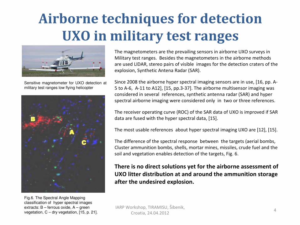
Airborne techniques for detection
UXO in military test rangesThe magnetometers are the prevailing sensors in airborne UXO surveys in Military test ranges. Besides the magnetometers in the airborne methods are used LIDAR, stereo pairs of visible images for the detection craters of the explosion, Synthetic Antena Radar (SAR).
Since 2008 the airborne hyper spectral imaging sensors are in use, [16, pp. A-5 to A-6, A-11 to A12], [15, pp.3-37]. The airborne multisensor imaging was considered in several references, synthetic antenna radar (SAR) and hyper spectral airborne imaging were considered only in two or three references.
The receiver operating curve (ROC) of the SAR data of UXO is improved if SAR data are fused with the hyper spectral data, [15].
The most usable references about hyper spectral imaging UXO are [12], [15].
The difference of the spectral response between the targets (aerial bombs, Cluster ammunition bombs, shells, mortar mines, missiles, crude fuel and the soil and vegetation enables detection of the targets, Fig. 6.
There is no direct solutions yet for the airborne assessment of
UXO litter distribution at and around the ammunition storage
after the undesired explosion.
4IARP Workshop, TIRAMISU, Šibenik,
Croatia, 24.04.2012
Sensitive magnetometer for UXO detection at military test ranges low flying helicopter
Fig.6. The Spectral Angle Mapping classification of hyper spectral images extracts: B – ferrous oxide, A – green vegetation, C – dry vegetation, [15, p. 21].
Airborne hyper spectral assessment of contamination by hazardous waste
5IARP Workshop, TIRAMISU, Šibenik,
Croatia, 24.04.2012
The assessment of the contamination by hazardous waste is developed technology in the USA,
based on the16 airborne real-time cueing hyper spectral enhanced reconnaissance systems
(ARCHER), [18], [19].
The hyper spectral aerial reconnaissance is applied in ARCHER also for search and rescue, disaster
impact assessment and relief, and homeland security, besides for the hazardous waste
assessment.
The used hyper spectral technology is capable of detecting anomalies, and objects significantly
different from the background in which they are located, can detect and find any object on the
ground that match the spectral signature.
This successful technology is very encouraging while it supports the basic assumption about
possibility to assess spatial distribution of UXO litter after the explosion of the ammunition
storage.

Airborne multisensor acquistion
system
The requirements in a case of the ammunition storage explosion is simpler, however the targets aresmaller and the main problem is to provide high probability of the detection, locating, recognizing them. The technology that enables to perform new requirements combines [1]:• very high spectral resolution (95 channels, from 430 nm to 900 nm) of the imaging hyper spectral
sensor, with inertial positioning system and the parametric geocoding,• very high spatial resolution, of the electro optical sensors (multisensor imaging) in the visible and in
near infra red and in long wave infra red wavelengths.
6IARP Workshop, TIRAMISU, Šibenik,
Croatia, 24.04.2012
HCR Center for testing, development and training Ltd Zagreb (www.ctro.hr) and Faculty of Geodesy University of Zagreb, (www.geof.unizg.hr), Croatia, have the airborne hyper spectral and multisensor imagery acquisition system, [1], [2]. This system was developed and operationally used in humanitarian demining since 2008, due to very strong support of US Department of State via ITF, [20].

Basic needsThe other sensors in the system are multispectral camera MS-4100, thermovision cameras (FLIR
Photon,
Agema THV-1000) and digital color camera. They acquire images in the same flight and conditions like
the hyper spectral imaging sensor but with better spatial resolution.
The dimensions of the smallest target determine altitude above terrain which enables imaging with
needed spatial resolution and coverage, therefore the enabling required probability of the detection,
recognizing in accordance to Johnson’s criteria.
The multispectral sensor enables analysis of the vegetation stress due to the contamination and variety
of indices can be derived and applied.
The high spectral resolution, the measured and collected spectral samples of the considered targets,
soil, and vegetation, enable increase of the probability of the detection and recognizing. The fusion of
the hyper spectral and multisensor imagery provides more then the sum of the results provided
by each sensor separately.
7IARP Workshop, TIRAMISU, Šibenik,
Croatia, 24.04.2012

Pre-flight calibration
The calibration of the radiometry of the hyper spectral imaging sensor has the crucial importance. Fig. 7, showsexample of the pre-flight calibration, Fig. 8, shows objects used in the field to assist calibration.
8IARP Workshop, TIRAMISU, Šibenik,
Croatia, 24.04.2012
Fig. 7. Pre-flight radiometric calibration. On the concrete surface is located Spectralon Multi-step target, SRT-MS-180.
Fig. 8. Spectral samples of the field objects measured on the ground by portable field spectro-radiometer FieldSpec®3 (ASD Inc., USA).

Airborne hyper spectral detection
of similar objectswith small spectral
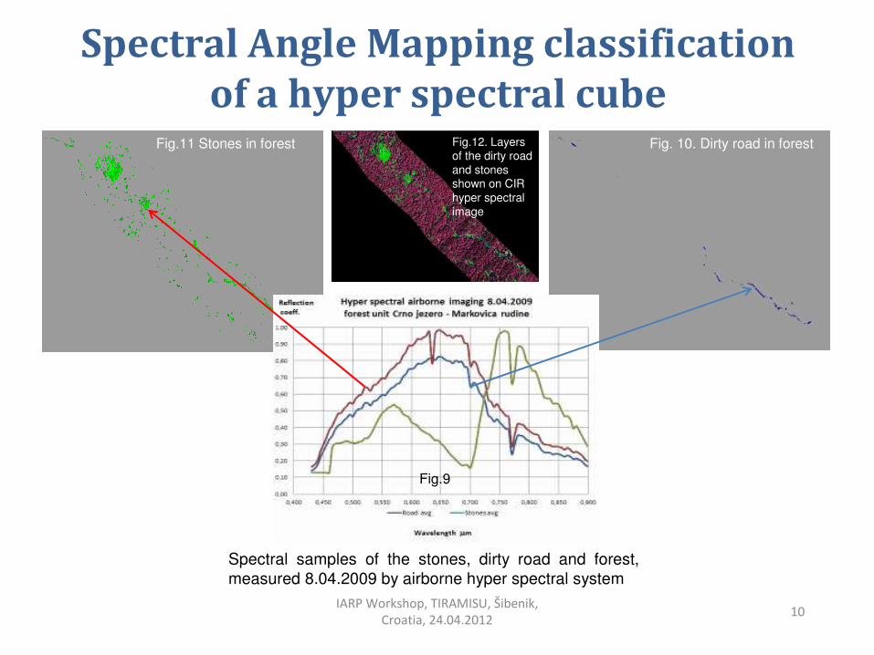
diferencesThe reflection spectra measured in one airborne mission are shown on Fig. 9.
The spectral samples from Fig. 9 are used for spectral angle mapping (SAM) classification aimed to extract the dirty road and stones from the hyper spectral image of the forest unit named Crno jezero – Markovica rudine, near Gospic, Croatia. The dirty forest road is obscured by trees, the soil contains stones, nevertheless the spectra differ, Fig. 9, and it was detectd when the suitable treshold spectral angle was selected, Fig. 10.
Both, the layer of the dirty road and the layer of the stones were overlapped on the hyper spectral image Fig. 12. The image was visualized from following wavelengths: 760 nm – red, 650 nm – green, 570 nm – blue, usually named color infra red (CIR).
The ground resolving distance of the presented hyper spectral images was 1 m, while the spectral resolution was 4,9 nm. The spatial resolution for the survey of the exploded ammunition storage and its neighborhood should be changed.
9IARP Workshop, TIRAMISU, Šibenik,
Croatia, 24.04.2012
Spectral Angle Mapping classification
of a hyper spectral cube
10IARP Workshop, TIRAMISU, Šibenik,
Croatia, 24.04.2012
Fig.11 Stones in forest Fig. 10. Dirty road in forest
Spectral samples of the stones, dirty road and forest,
measured 8.04.2009 by airborne hyper spectral system
Fig.12. Layers of the dirty road and stones shown on CIR hyper spectralimage
Fig.9

References
[1] Bajić M., Gold H., Fiedler T., Gajski D., (2008). „Development of a concept from 1998 and realization of the system for the airborne multisensor reconnaissance and surveillance in crisis situations and the protection of the environment in 2007 – 2008”, Proceedings of the First International Conference on Remote Sensing Techniques in Disaster Management and Emergency Response in the Mediterranean Region, Zadar, Croatia 22-24, Sept. 2008, ed. M. Oulić, EARSeL, pp.401-410.
[2] Bajić, M., (2003). „Survey of suspected mined areas from a helicopter“, Journal of Mine Action, James Madison University, Issue 7.3, 2003, pp. 54-58.
[3] GICHD, (2002). „Explosive Remnants of War (ERW) Undesired Explosive Events in Ammunition Storage Areas“, Geneva International Centre for Humanitarian Demining, Geneva November 2002. ISBN 2-88487-006-7.
[4] GICHD, (2008). „A Guide to Ammunition Storage“, First Edition, Geneva International Centre for Humanitarian Demining, Geneva, November 2008. ISBN 940369-15-1. pp.61-62
[5] UNDAC, (2008). „Assessment and recommendations following the Gerdec Explosions , Albania 20 March – 3 April, 2008“, United Nations Disaster Assessment & Coordination, Report 8 April 2008.
[6] Nelson H., Kaye K., Andrews A., (2008). „ESTCP Pilot Project Wide Area Assessment for Munitions Response“, Final report, Environmental Security Technology Certification Program, US DoD, July 2008.
[7] Šimunović Dražen, 2011, “Calculation of Safe Distance from the Bursting Effect during Detonation of explosive Ordnances”, International Symposium “Humanitarian Demining 2011”, 26 to 28 April 2011, Šibenik, Croatia, Proceedings pp. 53-58.
[8] TNMA, „Estimation of Explosion Danger Areas“, Technical Note 10.20 / 01, Version 2.0, Geneva International Centre for Humanitarian Demining, Geneva.
[9] Department of Peacekeeping Operations, 2002, “Disarmament, demobilisation and reintegration of ex-combatants in a peacekeeping environment, Revised principles and guidelines for the collection and destruction of ammunition”, UN Department of Peacekeeping Operations, Revision 0, September 2002.
[10] Department of the Army, 2011, “Safety Ammunition and Explosives Safety Standards”, Pamphlet 385–64, Headquarters Department of the Army Washington, DC, 24 May 2011
[11] UNODA, (2011). „Introduction to risk management principles and processes“, The International Ammunition Technical Guidelines, IATG 02.10, 01.10.2011. United Nations Office for Disarmament Affairs (UNODA)
[12] Doll W.E., Hamlett P., Smyre J., Bell D., Nyquist J., T. J. Gamey T.J, Holladay J.S., (1999). „A field evaluation of airborne techniques for detection of unexploded ordnance“, ORNL/CP-101923, Oak Ridge National Laboratory, MS 6038, P O Box 2008, Oak Ridge, TN, 3.03.1999.
[13] Hathaway J., Pulsipher B., Roberts B., McKennaS., (2008). „Demonstration and Performance Assessment of Statistical Methods for UXO Characterization, Wide Area Assessment: Camp Beale“, CA, Interim Report ESTCP Project MM-0325, Final Report, August 26, 2008.
[14] UXO-6, (2010). „Technology Overview Frequently Asked Questions about Wide-Area Assessment for Munitions Response Projects“, The Interstate Technology & Regulatory Council Unexploded Ordnance Team, May 2010.
[15] Foley J., Patterson C., (2007). „Demonstration of Airborne Wide Area Assessment Technologies at Pueblo Precision Bombing Ranges, Colorado – Hyperspectral Imaging“, Final Report , Project No. 200416, Prepared by Sky Research, Inc. 445 Dead Indian Memorial Road Ashland, OR 97520, September 27, 2007, Final v. 2.0
[16] Nelson H., Kaye K., Andrews A., (2008). ESTCP Pilot Project Wide Area Assessment for Munitions Response, Final report, Environmental Security Technology Certification Program, US DoD, July 2008.
[17] Nelson H.H., McDonald J.R., Wright D. 2005, „Airborne UXO Surveys Using the MTADS“, Naval Research Laboratory Washington, DC 20375, NRL/MR/6110--05-8874, April 2005.
[18] N. Carbone, Missouri C. Blodgett, B. Doster, R. Lea, (2005). Contamination Characterization Through Airborne
Hyperspectral Imagery (HSI) Pilot Project Final Report,
Missouri Department of Natural Resources and U.S. Environmental Protection Agency Office of Solid Waste and Emergency Response, September 1, 2004 - December 31, 2005.
[19] MODNR, (2009). “2005 – 2009 Project to Develop Applications of Civil Air Patrol Hyperspectral Imagery for Characterizing Contamination, Monitoring Remediation, and Continued Site Stewardship”, Missouri Department of Natural Resources, June 2009.
[20] Bajić, M., (2010). “The advanced intelligence decision support system for the assessment of mine suspected areas”, Journal of ERW and Mine Action, James Madison University, Issue 14.3, Fall 2010, Available: 1.03.2011, URL: http://maic.jmu.edu/journal/14.3/r_d/bajic/bajic.htm
[21] Yvinec, Y., Bajic, M., Dietrich, B., Bloch, I., Vanhuysse, S., Wolff, E., Willekens, J., (2005). „Final Report, Space and Airborne Mined Area Reduction Tools, project SMART“, European Commission IST-2000-25044, V3, Classification: Public, 20.04.2005, 46 p. URL: http://www.smart.rma.ac.be
11IARP Workshop, TIRAMISU, Šibenik,
Croatia, 24.04.2012

Acknowledgment to sponsor and for
financial support
1. Croatian Ministry of Defense, for data, information about the ammunition storage Padjene.
2. FP7 TIRAMISU (2012-2015), Toolbox Implementation for Removal of Anti-personnel Mines, submunitions and UXO, FP7 of European Union, ResearchExecutive Agency, Collaborative Project - Large-scale Integration Project, FP7-SEC-2011-1, Grant Agreement Number 284747, FP7-SEC 2011-284747, 3.11.2011.
12IARP Workshop, TIRAMISU, Šibenik,
Croatia, 24.04.2012

Amendment to DoW of FP7 project
TIRAMISU
Due to initiative of Yann Yvinec and due to contribution and support of Yvan Baudoin was derived TIRAMISU DOW amendment – SWP 224, SWP 233, SWP 512
Airborne hyper spectral and multisensor assessment of
Unexploded ordnance litter at and around ammunition storage
after explosion
13IARP Workshop, TIRAMISU, Šibenik,
Croatia, 24.04.2012