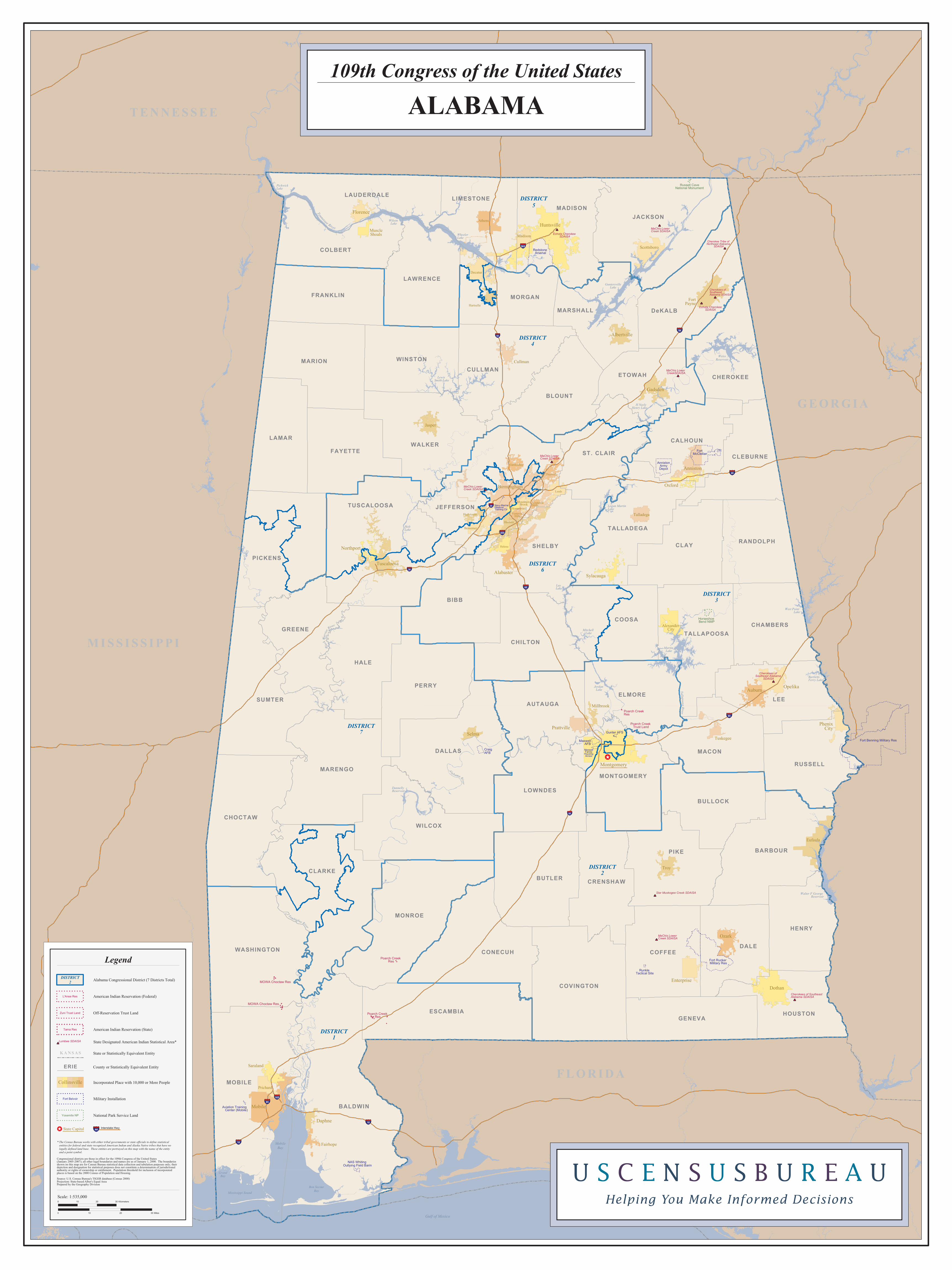
alabama - census colbert bullock franklin etowah lawrence calhoun talladega autauga houston marshall...

1
Vestavia Hills Poarch Creek Res Poarch Creek Res Poarch Creek Trust Land 65 20 20 65 T e nne s s e e Ri v e r Muscle Shoals Hartselle Fort Payne Scottsboro Cullman Jasper Tuskegee Millbrook Troy Eufaula Saraland Fairhope Gardendale Trussville Leeds Pelham Helena Sylacauga Oxford Montgomery Echota Cherokee SDAISA 10 65 20 85 459 59 565 165 10 65 BALDWIN MOBILE LEE CLARKE PIKE BIBB DALLAS HALE MONROE JACKSON WILCOX CLAY SUMTER PERRY DALE SHELBY PICKENS TUSCALOOSA BUTLER MARENGO DeKALB JEFFERSON WALKER COOSA MARION BARBOUR CHOCTAW ESCAMBIA MADISON COVINGTON LAMAR CONECUH COFFEE MACON HENRY GREENE BLOUNT CHILTON WASHINGTON ELMORE CULLMAN LOWNDES RUSSELL GENEVA FAYETTE WINSTON MORGAN ST. CLAIR COLBERT BULLOCK FRANKLIN ETOWAH LAWRENCE CALHOUN TALLADEGA AUTAUGA HOUSTON MARSHALL TALLAPOOSA MONTGOMERY CHEROKEE CHAMBERS CRENSHAW LAUDERDALE RANDOLPH LIMESTONE CLEBURNE Mobile Huntsville Birmingham Dothan Decatur Opelika Tuscaloosa Ozark Athens Auburn Anniston Gadsden Bessemer Hoover Enterprise Prichard Florence Madison Prattville Albertville Talladega Alexander City Selma Alabaster Northport Daphne Phenix City Hueytown Mountain Brook Homewood Vestavia Hills Fort Benning Military Res Redstone Arsenal Fort Rucker Military Res Fort McClellan Anniston Army Depot Craig AFB Maxwell AFB Gunter AFS NAS Whiting Outlying Field Barin Runkle Tactical Site Aviation Training Center (Mobile) Navy-Marine Reserve Training Ctr Maxwell Family Housing Annex Horseshoe Bend NMP Russell Cave National Monument Poarch Creek Res MOWA Choctaw Res MOWA Choctaw Res Mobile Bay Wheeler Lake Guntersville Lake Bon Secour Bay Martin Lake Pickwick Lake Mississippi Sound T e n s aw R i v er Weiss Reservoir A l a b am a R i v e r Lay Lake West Point Lake Wilson Lake Lewis Smith Lake T o m bi g bee R i v er Walter F George Reservoir Logan Martin Lake M o b i le R iver B l a c k W a r r i o r R i v e r Grand Bay H Neely Henry Lake Jordan Lake Dannelly Reservoir Holt Lake Mitchell Lake C o osa R iv er T a l l a p o o s a R i v er Bartletts Ferry Lake Gulf of Mexico GEORGIA MISSISSIPPI TENNESSEE FLORIDA DISTRICT 2 DISTRICT 7 DISTRICT 4 DISTRICT 3 DISTRICT 1 DISTRICT 5 DISTRICT 6 Echota Cherokee SDAISA MaChis Lower Creek SDAISA MaChis Lower CreekSDAISA Cherokees of Southeast Alabama SDAISA Cherokee Tribe of Northeast Alabama SDAISA MaChis Lower Creek SDAISA MaChis Lower Creek SDAISA Cherokees of Southeast Alabama SDAISA MaChis Lower Creek SDAISA Star Muskogee Creek SDAISA Cherokees of Southeast Alabama SDAISA Legend * The Census Bureau works with either tribal governments or state officials to define statistical entities for federal and state recognized American Indian and Alaska Native tribes that have no legally defined land base. These entities are portrayed on this map with the name of the entity and a point symbol. State Designated American Indian Statistical Area* Lumbee SDAISA American Indian Reservation (State) Tama Res Off-Reservation Trust Land Zuni Trust Land American Indian Reservation (Federal) L’Anse Res Military Installation Fort Belvoir State or Statistically Equivalent Entity KANSAS Interstate Hwy 44 State Capital Congressional districts are those in effect for the 109th Congress of the United States (January 2005-2007); all other legal boundaries and names are as of January 1, 2000. The boundaries shown on this map are for Census Bureau statistical data collection and tabulation purposes only; their depiction and designation for statistical purposes does not constitute a determination of jurisdictional authority or rights of ownership or entitlement. Population threshold for inclusion of incorporated places is based on the 2000 Census of Population and Housing. Source: U.S. Census Bureau’s TIGER database (Census 2000) Projection: State-based Alber’s Equal Area Prepared by the Geography Division Alabama Congressional District (7 Districts Total) DISTRICT 2 Incorporated Place with 10,000 or More People Collinsville Scale: 1:535,000 County or Statistically Equivalent Entity ERIE 0 10 20 30 Kilometers 0 10 20 30 Miles National Park Service Land Yosemite NP 109th Congress of the United States ALABAMA

Upload: hakhue

Post on 09-Jun-2018

214 views

Category:

Documents


0 download

TRANSCRIPT

Vestavia Hills

Poarch Creek Res

Poarch Creek Res

Poarch Creek Trust Land

65

20

20

65

Tennes

see River

MuscleShoals

Hartselle

FortPayne

Scottsboro

Cullman

Jasper

Tuskegee

Millbrook

Troy

Eufaula

Saraland

Fairhope

Gardendale

Trussville

Leeds

Pelham

Helena

Sylacauga

Oxford

Montgomery

Echota CherokeeSDAISA

10

65

20

85

459

59

565

165

10

65

BALDWIN

MOBILE

LEE

CLARKE

PIKE

BIBB

DALLAS

HALE

MONROE

JACKSON

WILCOX

CLAY

SUMTER

PERRY

DALE

SHELBY

PICKENS

TUSCALOOSA

BUTLER

MARENGO

DeKALB

JEFFERSON

WALKER

COOSA

MARION

BARBOUR

CHOCTAW

ESCAMBIA

MADISON

COVINGTON

LAMAR

CONECUH COFFEE

MACON

HENRY

GREENE

BLOUNT

CHILTON

WASHINGTON

ELMORE

CULLMAN

LOWNDES

RUSSELL

GENEVA

FAYETTE

WINSTON

MORGAN

ST. CLAIR

COLBERT

BULLOCK

FRANKLIN

ETOWAH

LAWRENCE

CALHOUN

TALLADEGA

AUTAUGA

HOUSTON

MARSHALL

TALLAPOOSA

MONTGOMERY

CHEROKEE

CHAMBERS

CRENSHAW

LAUDERDALE

RANDOLPH

LIMESTONE

CLEBURNE

Mobile

Huntsville

Birmingham

Dothan

Decatur

Opelika

Tuscaloosa

Ozark

Athens

Auburn

Anniston

Gadsden

Bessemer

Hoover

Enterprise

Prichard

Florence

Madison

Prattville

Albertville

Talladega

Alexander City

Selma

Alabaster

Northport

Daphne

PhenixCity

Hueytown

Mountain Brook

Homewood

Vestavia Hills

Fort Benning Military Res

Redstone Arsenal

Fort Rucker Military Res

Fort McClellan

AnnistonArmyDepot

CraigAFB

MaxwellAFB

Gunter AFS

NAS Whiting Outlying Field Barin

Runkle Tactical Site

Aviation Training Center (Mobile)

Navy-Marine Reserve Training Ctr

MaxwellFamily

HousingAnnex

Horseshoe Bend NMP

Russell CaveNational Monument

Poarch Creek Res

MOWA Choctaw Res

MOWA Choctaw Res

Mississippi Sound

Mobile

Bay

Wheeler

Lake

Guntersville

Lake

Bon Secour

Bay

Martin

Lake

Pickwick

Lake

Mississippi Sound

Tensa

w R

iver

Weiss

Reservoir

A

labama R

iver

Lay

Lake

West Point

Lake

Wilson

Lake

Lewis

Smith Lake

Tombigbee R

iver

Walter F George

Reservoir

Logan Martin

Lake

Mo

bile

Riv

er

Bla

ck W

arrio

r

Riv

er

Grand

Bay

H Neely

Henry Lake

Jordan

Lake

Dannelly

Reservoir

Holt

Lake

Mitchell

LakeCo

osa R

iver

Talla

po

osa

Riv

er

Bartletts

Ferry Lake

Gulf of Mexico

GEORGIA

MISS ISS IPP I

TENNESSEE

FLORIDA

DISTRICT2

DISTRICT7

DISTRICT4

DISTRICT3

DISTRICT1

DISTRICT

5

DISTRICT6

Echota Cherokee SDAISA

MaChis Lower Creek SDAISA

MaChis Lower CreekSDAISA

Cherokees of Southeast Alabama SDAISA

Cherokee Tribe of Northeast Alabama

SDAISA

MaChis Lower Creek SDAISA

MaChis Lower Creek SDAISA

Cherokees of Southeast Alabama

SDAISA

MaChis Lower Creek SDAISA

Star Muskogee Creek SDAISA

Cherokees of Southeast Alabama SDAISA

Legend

* The Census Bureau works with either tribal governments or state officials to define statistical

entities for federal and state recognized American Indian and Alaska Native tribes that have no

legally defined land base. These entities are portrayed on this map with the name of the entity

and a point symbol.

State Designated American Indian Statistical Area*Lumbee SDAISA

American Indian Reservation (State)Tama Res

Off-Reservation Trust LandZuni Trust Land

American Indian Reservation (Federal)L’Anse Res

Military InstallationFort Belvoir

State or Statistically Equivalent EntityKANSAS

Interstate Hwy44State Capital

Congressional districts are those in effect for the 109th Congress of the United States(January 2005-2007); all other legal boundaries and names are as of January 1, 2000. The boundariesshown on this map are for Census Bureau statistical data collection and tabulation purposes only; theirdepiction and designation for statistical purposes does not constitute a determination of jurisdictionalauthority or rights of ownership or entitlement. Population threshold for inclusion of incorporatedplaces is based on the 2000 Census of Population and Housing.

Source: U.S. Census Bureau’s TIGER database (Census 2000)Projection: State-based Alber’s Equal AreaPrepared by the Geography Division

Alabama Congressional District (7 Districts Total)DISTRICT

2

Incorporated Place with 10,000 or More PeopleCollinsville

Scale: 1:535,000

County or Statistically Equivalent EntityERIE

0 10 20 30 Kilometers

0 10 20 30 Miles

National Park Service LandYosemite NP

109th Congress of the United States

ALABAMA