alaska state legislature
TRANSCRIPT

APPENDIX #1
ALASKA STATE LEGISLATURE
CONFLICTS CONCERNING TITLE TO SUBMERGED LANDS TN ALASKA
By: Ron Somerville, Resource Consultantand
Ted Popely, Legal Counsel
Updated: 02/11/04
Statehood Entitlement — Submerged Lands
Alaska became a state in 1959 and under the Equal Footing Doctrine and the Submerged Lands Actinherited title to almost 60+ million acres of submerged lands. Unfortunately, since statehood, lessthan 20 rivers have been determined to be navigable by the federal courts. Although BLM has madenumerous navigability determinations and the Department of the Interior is presently workingpositively with the state to identify and issue a “Recordable Disclaimer of Interest” for navigablewaterways, the process is still painfully slow. Considering the fact that Alaska contains 20, 000+potentially navigable rivers and well over 1,000,000 lakes that could qualify as navigable, it could takeseveral life-times and billions of litigation dollars before Alaska realizes its entitlement, if at all. Inaddition, the passage of time weakens the state’s ability to provide the factual determinations necessaryto prove in a federal court that a waterbody was navigable at the time of statehood.
Issues of State Ownership of Submerged Lands
Alaska faces two types of legal hurdles in establishing its entitlement to submerged lands. Its mostcritical problem is to establish, in an efficient and timely manner, which of the state’s rivers and lakesare navigable. Alaska’s second hurdle is to determine which submerged lands the United States legallywithdrew prior to statehood. The state’s attempts to resolve these issues are thwarted by the extremelynarrow interpretation the United States gives to the federal Quiet Title Act and by the lack of a non-judicial process to determine title.
The Basis of the State’s Claim of Title to Submerged Lands
Alaska owns the submerged lands underlying navigable waters and marine waters seaward three milesby virtue of the Equal Footing Doctrine and the Submerged Lands Act of 1953. The Equal FootingDoctrine dictates that new states enter the Union with all of the powers of sovereignty and jurisdictionthat pertain to the original states. When a state enters the Union, it takes title to the lands underlyingnavigable waters and between mean high and mean low tide as a matter of constitutional right, subjectonly to the paramount federal power to control the waters for navigation in interstate and foreigncommerce. The Submerged Lands Act conveys lands under marine waters and also includes landsunderlying inland navigable waters to confirm their automatic passage under the equal footingdoctrine.

For purposes of title to submerged lands, waters are navigable when they are used or susceptible ofbeing used in their natural and ordinary condition as highways for commerce over which trade andtravel may be conducted. Unfortunately, only a handful of waterways have been adjudged navigablesince Alaska’s statehood, because of the unwillingness of the United States to settle navigability issuesoutside litigation, and because of the jurisdictional difficulties of litigating navigability against theUnited States.
Despite the Equal Footing Doctrine and the Submerged Lands Act, the United States claims title tomost or all of the state’s submerged lands within the 25% of Alaska that the federal government hadreserved before statehood. This issue is governed by Utah Division ofLands v. United States, 482 U.s.193 (1987). Commonly referred to as the “Utah Lake” case. In Utah Lake, the court held that in orderto establish that it retained title to submerged land within a reservation, the United States mustestablish (1) that Congress clearly intended to include submerged lands in the withdrawal, and (2) thatCongress affirmatively intended to defeat the future state’s title to submerged lands. In Utah Lake, thecourt found that the United States did not establish congress’ intent to include the lake-bed in thereservation, despite the fact that the purpose of the reservation was to preserve the lake for a reservoir.
Navigable Waters Jurisdictional Issues
Some federal agencies have issued regulations governing activities on navigable waters flowingthrough federal lands. The extent of their authority to do so is unclear. In some instances the agencymay have Commerce Clause authority (e.g. promulgating regulations to implement environmentallaws) but the more difficult question is the scope of an agency’s authority whose mandates are notdirectly related to water, but are tied to land management, such as the National Forest Service,National Park Service, National Fish and Wildlife Service and Bureau of Land Management. TheCourt of Appeals for the Eighth Circuit has held that some agencies may regulate non-public landsunder the Property Clause if the activities could negatively affect the purpose of the federalreservation. In Alaska, the more common scenario is an agency restricting public access on navigablewaters within a reservation, such as requiring restrictive permits to conduct commercial activities on awaterway.
Navigability Criteria Conflicts
Where title to submerged lands is at stake, the dispositive issue is usually the navigability of the watersthat overlie them. The United States Bureau of Land Management (BLM) makes navigabilitydeterminations infrequently, only for lakes less than 50 acres and rivers less than three chains (19$feet) wide, and only when it is conveying the adjacent uplands. When waterways are larger than thesemeasurements BLM conveys the adjacent and non-submerged land without navigabilitydeterminations. Even when BLM finds a smaller waterway non-navigable, however, it maintains thatthe determination is relevant only to the amount of acreage it is conveying and does not reflect afederal position on title.
The greatest hurdle to overcome in the State’s efforts to identify and manage navigable waters hasbeen the long-standing differences of opinion between the State of Alaska and the United Statesregarding the application of the test for determining title navigability. Navigability is a question offact, not a simple legal formula. Variations in waterbody use that result from different physical
2

characteristics and transportation methods and needs must be taken into account. There are many legalprecedents for determining navigability in other states based upon the particular facts presented inthose cases.
The physical characteristics and uses of a waterbody used by the State for asserting navigability“criteria,” are based upon legal principles that have been established by the federal courts. Thesecriteria are applied to rivers, lakes, and streams throughout the State and take into account Alaska’sgeography, economy, customary modes of water-based transportation, and the particular physicalcharacteristics of the waterbody under consideration.
To resolve these navigability criteria disputes, the State has actively pursued a limited number of courtcases challenging particular findings of non-navigability by the federal government. Some of theimportant cases are:
Gulkana River. In this case, both in the U.S. District Court and on appeal to the U.S. Court ofAppeals, the federal courts rejected the federal government’s restrictive interpretation of thephrase “highway of commerce” in the title navigability test. The federal district court statedthat to demonstrate navigability, it is only necessary to show that the waterbody is physicallycapable of “the most basic form of commercial use: the transportation of people or goods.”Because the Gulkana River can be used for the transportation of people or goods, the GulkanaRiver was found navigable. The court of appeals found that the modern use of the GulkanaRiver for guided hunting, fishing, and sightseeing trips is a commercial use and, since thephysical characteristics of the river have not significantly changed since 1959, providesconclusive evidence that the river was susceptible of commercial use at statehood. The courtalso found that modern inflatable rafts can be used to establish navigability. In 1990, the U.S.Supreme Court denied the request to review and overturn the decision and, thus, the GulkanaRiver precedent is now binding on all future navigability determinations in Alaska.
Kandik, Nation and Black Rivers. In this case, the State and Doyon Limited successfullyestablished that the use or susceptibility of use of a river or stream by an 18-24 foot woodenriverboat capable of carrying at least 1,000 pounds of gear or supplies is sufficient to establishnavigability. Based upon the use of these types of boats for the transportation of goods andsupplies by trappers, as well as extensive historic and contemporary canoe use, the federalcourts found the Kandik and Nation rivers navigable and, due to a technical interpretation ofthe federal Quiet Title Act, failed to rule on the Black River. The Department of the Interiorissued a “Recordable Disclaimer of Interest” for the Black River, however, in 2003.
Alagnak River, Nonvianuk River, Kukaldek Lake and Nonvianuk Lake. In this federaldistrict court case, the Alagnak River, Nonvianuk River, Kukakiek Lake and Nonvianuk Lakewere all found navigable. Their primary transportation use is for commercially guided hunting,fishing, and sightseeing and for government research and management. They also serve as ameans of access for local residents to their homes and to the surrounding areas for subsistencehunting and fishing.
3

From the standpoint of the public, the state and the federal governments both contribute to theconfusion over navigability determinations. The State Policy on Navigability adopted by the AlaskaDepartment of Natural Resources includes the following explanations:
“When information is lacking, and it must make a navigability determination, the stateis forced to rely solely upon the physical characteristics shown on maps and aerialphotographs. In these cases, the state identifies as navigable all streams depicted on theU.S.G.S. maps with double lines (generally at least 70 feet wide) and having an averagegradient over the length of the stream of no more than 50 feet per mile.”
“Streams depicted with single lines, although narrower in width, may also be listed aspotentially navigable if they have gradients of substantially less than 50 feet per mileand are at least 10 miles.”
“If a lake is totally isolated, it will be included on the state’s navigability maps if it is atleast 1 ½ miles long. That length insures that the lake can be used as a highway.”
“An isolated lake might need to be 2-3 miles long to be included on the state’snavigability maps.”
• . those lakes which are shown on maps and aerial photographs as having a navigablewater connection with other navigable waters, or which are accessible by short overlandportages, are considered navigable regardless of the size of the lake.”
Clouded Titles Due to Erroneous NaviabiIity Determinations
The standard procedures for surveying and conveying federal land are found in the Manual ofInstructions for the Survey of the Public Lands of the United States. Under those procedures,consistently used in every public land state except Alaska, only uplands are surveyed and conveyed infulfillment of acreage entitlements, not submerged lands. The survey rules require that all lakes 50acres or larger, and rivers and streams three chains (198 feet) in width or wider, regardless ofnavigability, be meandered rivers, lakes, and streams is not included in computing the amount of landinvolved in the conveyance.
In Alaska, however, the federal government had not consistently followed these survey rules. Until1983, the federal government treated submerged lands the same as uplands. All bodies of water thatwere considered non-navigable by the federal government, regardless of size, were surveyed as thoughthey were uplands and the acreage of submerged lands were charged against the total acreageentitlement.
Because of these conveyance procedures, the navigability of waterbodies in Alaska has been an issueof contention since the enactment of the Alaska Statehood Act and ANCSA. In addition to theproblems caused by a lack of information about many waterbodies, the situation was exacerbated bythe narrow definition of navigabitity used by the federal government. Hundreds of rivers, lakes andstreams considered navigable by the state were determined non-navigable by the federal government.
4

In 1983, the Department of the Interior agreed that the standard rules of survey should be followed forland conveyances in Alaska. The recipients of conveyances from the federal government are chargedonly for the amount of public land is calculated by the survey, which does not include the areas ofmeandered rivers, lakes and streams. This decision by the Department of the Interior was legislativelyapproved in 1988.
Despite the fact that the use of these survey procedures has eliminated many of the land conveyanceproblems after 1983, a major problem concerning navigability decisions made by the federalgovernment under the old system remains unresolved. At issue are the hundreds of erroneous non-navigability decisions and the resulting submerged land conveyances made to ANCSA corporations inprevious years. This issue becomes more critical as efforts are made by the federal government toestablish a deadline for completing land conveyances. ANCSA corporations may be unable to replaceerroneously conveyed submerged lands if the selection process had been terminated.
Difficulties Ouietin Title to Submerged Lands
The State must file a Quiet Title Action in federal court to definitively resolve a dispute with thefederal government regarding ownership of a navigable water body. The federal government has madeit very difficult to quiet title. The Quiet Title Act provides that the United States may be named as aparty defendant in a civil action “to adjudicate a disputed title to real property in which the UnitedStates claims an interest.” 28 U.S. C. § 2409a(a). The United States has adopted a very narrow viewof the term “claims and interest,” asserting that the federal court has no jurisdiction to hear quiet titleactions against it unless the federal government actively and expressly asserts an interest in the lands.In the context of the submerged lands, this will occur only in rare circumstances.
While the Ninth Circuit Court of Appeals has decided that a federal non-navigability decision is asufficient federal claim of interest to give the court jurisdiction under the Quiet Title Act, for these fewwaterways the State still may be unable to get a judgment, for the following reason. The State receivesnotice of a non-navigability determination when BLM issues a conveyance decision. Both because theState must give 180 days notice under the Quiet Title Act before filing a complaint, and because apreliminary injunction to prevent the conveyance is unavailable under the Quiet Title Act, the UnitedStates will likely convey the lands to a third party before the State can do anything to prevent it, andthe State could arguably lose its cause of action against the United States.
Therefore, the State rarely has a viable cause of action to quiet title to submerged lands. The UnitedStates is in virtually the same position it was before the Quiet Title Act was passed: it controls whenand how a court resolves title disputes. The exception to this general rule will be title disputes basedon the issue of whether the United States defeated the State’s right to submerged lands beforestatehood, where the United States has expressly taken a position.
The final legal determination of whether a water-body is navigable is a complex process requiringfactual determinations that a waterway had been effectively used for commerce prior to statehood. Inthe States’ litigation to quiet title to the Black, Kandik, and Nation Rivers in northeast Alaska, a panelfor the Ninth Circuit Court of Appeals noted in January, 2000:
5

“There is also a serious policy concern in favor of allowing resolution of disputes based on theUnited States’ inchoate claim to everything in Alaska but what it has disclaimed. Eventually,all the witnesses will be dead, reducing the reliability of litigation. Someone who used one ofthese rivers in 1959 at age 20 is now 60. The population in the area was so sparse at all
relevant times — probably no more than a couple of hundred people who might have used thethree rivers during the relevant time, most too young to have relevant knowledge or too old tohave survived the forty years since statehood — that a few deaths by old age can remove most orall the knowledgeable witnesses. Also, a state entitled as of 1959 to all the incidents ofownership in its rivers, yet still deprived of clear title forty years later, is effectively deprived ofwhat it is entitled to under the equal footing doctrine.”
In addition, the process has become incomprehensibly complicated and expensive. A case in point isthe quiet title action by the State to resolve submerged lands ownership under the Black, Kandik andNation rivers in northeast Alaska. These three rivers clearly meet the criteria established by the federalcourts for determining navigability in Alaska. Despite the fact that no one contested the State’s claimthat these three rivers met the federal courts criteria for determining navigability, this case took nineyears and upwards of a million of state and federal dollars to litigate, eventually resulting in the Statewinning two of the three cases and achieving no solution on the third.
Solutions Through Administrative Action — Recordable Disclaimer of Interest
Following meetings with the Legislative leadership in 2002, the Department of the Interior offered toexamine the possibility of using a “Recordable Disclaimer of Interest” as a means of resolvingsubmerged lands title disputes between the state and the federal government. In 2003, the Departmentof the Interior issued a “Recordable Disclaimer of Interest” in the Black River located in NortheastAlaska. This River was one of three rivers in that region that the ownership of the submerged landswas not resolved through litigation.
The legislature, through Legislative Budget and Audit, has funded a special project for the AlaskaDepartments ofNatural Resources and Fish and Game to expedite the petition process to theDepartment of the Interior for issuing “Recordable Disclaimers of Interest” for navigable waters andRS 2477 Rights-of-way. The major emphasis of the project has been directed at navigable waters.Some petitions are pending and others are due to be submitted early in 2004.
Solutions Through Federal Legislation
A. Changes to the Quiet Title Act. The precise issue in dispute between the state and the UnitedStates is what should require the United States to “claim an interest” so as to trigger jurisdictionunder the Quiet Title Act. A provision in the Quiet Title Act that defines this phrase broadlyenough to permit the state to quiet title to its submerged lands would resolve the issue. Thiswould require a definition that makes the existence of a legal cloud on title sufficient toconstitute a federal claim of interest, so that the United States’ refusal to take a position as tonavigability for title purposes of waters on federal lands would give the state a cause of actionin federal court.
6

B. Joint State/Federal Navigable Waters Commission. In 1971, Congress and the State ofAlaska respectively created a Joint Federal/State Land Use Planning Commission for Alaska toassist in the massive land-use planning process following passage of the Alaska Native ClaimsSettlement Act. The State Legislature passed a bill in 2002 to create a similar State/FederalCommission for the purpose of expediting navigability determinations and providingrecommendations for ways to improve the process of making water use and navigabilitydecisions in Alaska. Similar legislation was introduced in Congress by the Alaska delegationto create the federal portion of the Commission. Unfortunately, this legislation did not pass asthe federal and state administrations looked for other ways to accelerate title disputeresolutions.
Examples of Navigability Complexities & Additional Information
Appendix A is a copy of the State of Alaska’s August 27, 1992 notice to Secretary of the Interior,Manuel Lujan, Jr. of its intent to quiet title to submerged lands described under 194 specific waterbodies in Alaska. Similarly, Appendix B contains a copy of the official notice to Secretary of theInterior Bruce Babbitt of the State’s intent to quiet title to submerged lands described under anadditional 9 water-bodies. Most of the water-bodies listed in Appendix A and Appendix B have beenrecognized by the Bureau of Land Management as being navigable for land conveyance purposes buthave maintained that this assertion is not for title purposes.
7

J., £iU FtA Ui .Q( .41h t1Ul tI1t(VLL—Lt LJUV
/1 :;::: GO VERNOR
I ii WEST 4ThAVEJUE, SUITE 2O/ ACHQPAGE. ALASKA 9950 -
DEPARTMENT OF LAW I PHONE: 25JCr
L / / FAx. (9O7 Z7S3697
IOFFICE Q THE ORNEY GENERAL / !JU7TE 400
Zr FAJl8ANKS. ALASKA 9970 7-4?9
1 Z f PH0N.. (7) 457-291’
I \ r1W / If FAX. (271 457-2844
‘ 7 August 27, 1992 i P0. BOX 7lø3-5TATECAPOL\j j,JI / JUNAU,AL.4SKA 995I1.cO
PHONE. (7J 46S36X
7 FAX: (X7) 463-5295
Manuel Lujan, Jr., SecretaryDepartment of the Interior1849 C Street NWWashington, D.C. 20240
Dear Mr. Lujan:
The State of Alaska intends to file real property quiet titleactions as to the submerged lands described on the list attached asappendix A, and is providing you this notice pursuant to 28 U.S.C.S2409a(m) . Title to these lands passed to Alaska at statehoodbased on the equal footing doctrine, the Submerged Land Act of May22, 1953, P.L. 83—31, 67 Stat. 29, 43 U.S.C. SS13O1 andthe Alaska Statehood Act of July 7, 1958, P.L. 85-508, 72 Stat.339, 48 U.S.C. note preceding 521.
Sincerely,
CHARLES E. COLEATTORNEY GENERAL
By: ‘,,
/%1oanne M. Grace
7 Assistant Attorney GeneralJMG/sh VAttachment
cc: I. T. Tangen, Regional Solicitor, Department of InteriorEdward F. Spang, State Director, Bureau of Land ManagementNiles Cesar, 1rea Director, Bureau of Indian AffairsWalter Stieglitz, Regional Director, Fish and Wildlife ServiceJohn Morehead, Regional Director, National Park Service
&417 /Z /JLL
— ——

I/I’U lb:U1 IA JU? b( t4iZ ANCHU1{A(i. FAYIWLL-CF LJOO6
7_’•
?qerxjjx A to 1ettr of ALqust 27, 2.992. --
QD1Vi]Je }€qic3
?krth of 1vi11e River to Nuka Riverxith of -ir River to aforrk
Nartt Iic
th of iapk River to tican River>xith of ?irican River to xki Ckxth of Bc)dani River to West Forkrth of Fish River to Cxn lic Creeksouth of Niukiuk River toZth of Kaxk River to Lar Kob.ik Canyarith of Koyuk River to Di Lnuirz!‘cxith of Xuziin River to Nopaga River>outh of Npaga River to ‘flnner CreekMc,.1th of Nctak River to Aniuk RiverMcrth of Selawik River to K.xarak Rivera31J River‘Throat RiverUr1iJc RiverMouth of Unalakleet River to Trnnj1e Cree]c
Mouth of Hcqatza River to Hc LarxingMouth of K.cyukuk River to BettlesMouth of Mi1e fork to Win
Ur Yuk
Mcrth of Bearpaw River to Diaitruth of Beaver Creek to Victoria CreekBirch CrkMouth of Black River to Er1yMouth of C-iarda1ar River to North aix West ForksMxrth of arley River to Bear CreekMouth of Qtanika River to Steese Hiiway RrigecIristian Riverith of 1i River to Lake Creek (59 i1es)uth of Crockexi. Creek to BrieCrass RiverMouth of Hess Creek to North arx Sciith Forksyjth of Rcdzana River to Pitka Fork (79 ni1es)Jin Lake
of Kardik River to BcrxazyMouth of Nation River to Pi.’xdary
1
flA .WVflfl’.JL I fl S I’.UL.,L., ‘I
Mcxith of Portipjne River to BourzaryRay RiverMcuth of Sventymile River to rney CreekMouth of i.njek River to 1uickzij ik CreekziiU. of Thtork River to Bcxrzary
40 Mile Area
Forty Nile RiverMouth of Noth Fork Forty Mile River to Kinkith of Scz.th Fork Forty Mile River to Mauito Fork
South T&n
y.ith of Cu1itha River to To)cjt Riverath of KasiloW River to Tustxr€na Lake?kxxth of Kenai River to Kenai Lake
Lakei( River
LaJc.e Louise ar outletLakeMouth of 9cnt-a River to Portage CreekSusi LakeMouth of &Lsit River to Ir1ian RiverMoith of Thflceetna River to Cri1na CreekMouth ofThkit- River to Hcar Lake it1et
Lakecxth of Tyor River to Tyone Lake
of ‘enfra River to if1uen of its East e’ird West ForksJcinson RiverRi River
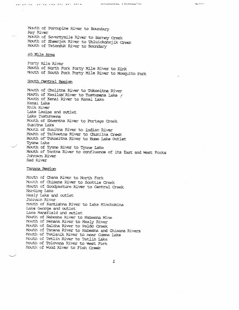
Mouth of 2-ier River to North ForkMouth of Qilsana River to Scxttie CreekMouth of Gccdpast.re River to Cena1 Creekq LakeHealy Lake rx outletJo1tDn RiverMouth of Kantishm River to Lake MirK±iurLin&Lake Crge ar outletLake Mansfield arrl ct1etMouth of Naisna River to Nana Mfrne1outh of Nenana River to Mealy RiverMouth of Salc.ha River to Paldo CreekMouth of Thnana River to Na1ia aM. Cliisana RiversMouth of Tec1anik River to near Ccar LakeMouth of Tetlin River to Tetlin LakeMouth of Tolovana River to Wt ForkMouth of Wcxd River to Fish Creek
2

A. £V us. I OUt I I 5. fl4’L1’flflUL tnLflvL.L.’. sj vuo
c1e Yujcrri River
?4rt1i of IrntDko River to jle Creek2iith of Idjtar River to Iditarto1 RiverLittle YIozia River
?1czitoa Riverof Nia River and Su1stra Rivers to Tair.arack Creek
Ti River
LrY
j,vJc RiverEoras ila RiverKctli)c .‘RIVer
Nulato RiverPastaIiJc River
River ±ci
Mcth of An.ialc River to Salnti-i River*.rth of Big River to Otter CreekMouth of Qiukcan River to Geniiik RiverCrDk creekMouth of st Fork Kuskakwim River to S1 Fork and Torzcra River?‘Szith o G€.2k River to Beaver Crk?th of George River to Julian Creek
-‘ ?‘tuth of Ho1i River to QuXan RiverHouit- River!.xth of Jdinsan River ü Mi CreeJ Pox-tage to Crook Creekith of Js River to Nurpitoxuk and AtoautluakKisaralik RiverMouth of Kuguklik River to Kipra]cKuilk LakeMcith of }O.skokwn River to North ForkLittle Tnzori RiverMouth of Mi1e Fork arx Big River to SalmDn RiverMouth of Mickuie Fork Kuskokwim River to PIt±a ForkMouth of Nin Fork to Ito West ForkMouti of Ncrh Fork Kuskckwir to Lake Mi,c}-nrn±na Portzigetlouto of cth Fork iskokwim River to Tatixa RiverMouth of Stcry River to Li VillageIuth of Swift Fork t Highp,.’er CreekMouth of Tkct’a River to Frth of July Creek?uth cf Talbiksok River to YuJcon—isko)cwi PortageMouth of Tuluksak River to Upper LardW1.jtefih Lake and outlet
-isto1 Fy ric
River c-Aniakohak River
3

‘iivi :uc rlA U( Ø( 4( A1NIUtAt,t rULL—cl- WJUU
— BLack Lake --
2tli of CThigrLi)c River to Black Lake c___ Ljk Lakeülikadrt-a River3uli RiverClark River?$z.ith of Ccççr River to Fa,ll.sDagc Creek -
Dxç SaThon River a
Rek RiverJc River aix3. arof Lakecia1ter Lake ard ,itlettuth of Gcdnews River to Watlanise Creek
of Igusiik River to ?nka Lakeilliara Lake1ith of Ill_iim River to Forksuth of Kanektak River to Kacatj LakeKakonaJc Laketh of Kir SaJirun River to O2ós Creek vMuth of KvidaX River to Illiaxw La)ceLake A1&o-aqi)cI.ake iaveukti1iLake ClarkLake BeverlyLake 1Ji)(Lake Ner)Lcer PRe La)çe ard outlet
—-“ Kokk River UKoki1i RiverZ’tk1q RiverMouth of Mu1chatra River to Smit Creeksouth of Na)ak River to Naknek LakeNukth1ik RiverNe.taien RiverNishlik LakeOutY of l1us1agak River to New StuythokMouth of Nuyakuk River to Nuyakuk LakeOroke RiverOsviak River2a’ny RiverPile Riverith Lake arzi outlet
-
Mouth of Sitlt Creek to re1t Lake -.rt of Snake River to ?Ln-availuk LakeShck RiverTh2rdna RiverMouth of Tiak River to Tik LakeTunulk RiverUalik LakeMouth of D9as’dJc River to Ler arx3. Upçxr Uash±k Lakes
Weary River
4

.‘ LQ V.L ).V LtA QUS .Vi 14. flVIZ’3L fVLL’.,F
Srth of xj pjv t rj
WRive eg±cr
Zth of Prir pjv- to rear Berirx I2kc1ct.h f River tc Tana Riyxth of Oçex- River to zulnetas (above Slana)
xrtYi of Lyak River arx Eya)( Lake?th of c1utm Piver to Gutina LakeIe RiverMi1 lake ard -it1etNeid-dna River
- Tasmcia River— %.uth of Tzllna River to Tazljna Lake
StIast Ficn
Dijflcat RiverCdIJccit RiverStidne River
sThn arxi iiicDf Strujt Reic
• Afck Lake‘tuth of Aftxnak River to the remains of t1e idge
— ar P Lakes?zy.ith of niakcak River to 1izt Ju-ison (eeKarluk Lake!‘cqjth of Kariuk River to Karluk Lake —
tatid rc2i
Yukon River
5

‘€J V V &
fl. —C -— — -—
—-
—
r r- TONY KNOWLES GOVERNoR.., !-:-- . _t .‘
- = -‘ PLEASE REPLY TO_-_ . L -J .. U .: __,. ... •‘ 103 WEST4THAVENUE SUITE200ANCHORAGE, ALASKA 9501-1993DEPARTMENT OF LAW
/ J OFFICE OF THE A7TORNEY GENERAL / 105AN3TUiTE4QoiIIY 7 PAIRBANK5, ALASKA 99701-4679ft, WI /A’ PHONE: (907)457-2871j\ ‘4,’ FAX. (907)45 1-2846
December 17, 1996 D P.O BOX 170300-OIMONOCOURTHOLJUNE4u. AL4SKA 99511-0300PHONE: (907) 465-3600FAX: (907)495-6 735
CERTIXD M.II -.RETUR2I RECEITREQUESTED
Bruce BabbittDepartment of the Interior1849 C Street NWWashington, D.C. 20240
Dear Mr. Babbitt:
The State of A1aka intends to file real propLty quiet titleactions as to the submerged lands described on te list attached asappendix A, and is providing you this notice pursuant to 28 U.s.C.S 2409a(m). Title to these lands passed to Alasica at stateioodbased on the equal footing doctrine, the SubmergedLand Act of May22, 1953, P.L. 83—31, 67 Stat. 29, 43 U.S.c. 55 1301 et seq., andthe Alaska Statehood Act of .u1y 7, 1958, P.L. 85—508, 72 Stat.339, 48 U.S.C. note preceding §21.
Sincerely,
BRUCE N. BOTELHOATTORNEY GENERAL
t:-
ie N. Graceistant Attorney General
Attachment
cc: Laurie Adams, Regional Solicitor, Departmntot InteriorTom Allen, State Director, Bureau of Land ManagementNiles Cesar, Area Director, Bureau of IndianAffairsDavid B. Allen, Regional Director, Fish and Wildlife ServiceRobert Earbee, Regional Director, National P4rk Service
03-C5Lfl

‘tJ V V s
C (
APPENIDIX A
ppr River RegionCopper River —
MQtern RegionKuic RiverMeade RiverKuicpowruk River
Eri5tol Bay RegionAro1k RiverKane1tok RiverKisar1ik RiverGoodnews RiverTogiaic River