aleppo profile · aleppo is the central city in the governorate. • aleppo governorate has 8...
TRANSCRIPT
Draft for
revision and endorsment
Draft for
revision and endorsment
CITY PROFILE ALEPPO Multi Sector Assessment
MAY2014
Aleppo
SYRIA
T U R K E Y
I R A Q
J O R D A N
L EB
AN
ON
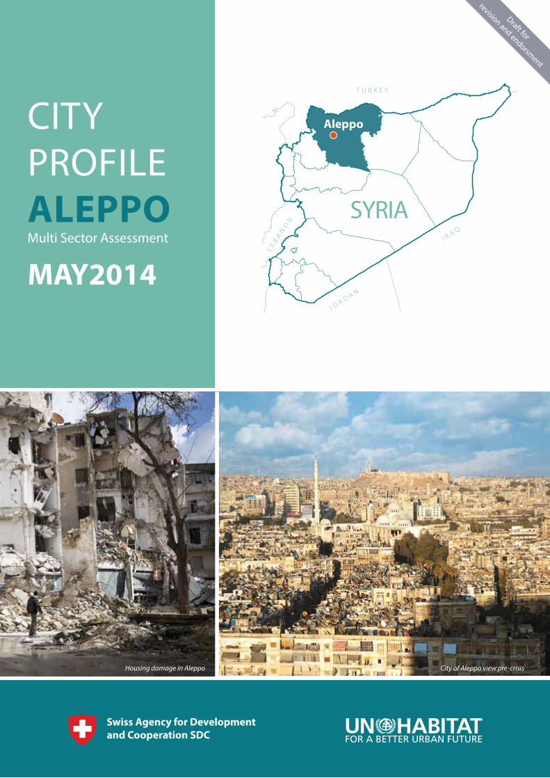
City of Aleppo view pre-crisisHousing damage in Aleppo

CITY PROFILE OF ALEPPO | MAY 2014
Draft for
revision and endorsmentAC K N O W L E D G E M E N TThe United nations Human Settlements Programme UN-Habitat presents it's gratitude to the Swiss Development Cooperation for providing financial support to develop the city profiles, which present a first ever comprehensive analysis of affected cities and humanitarian needs. Special thanks and acknowledgement to the field teams and facilitators for conducting the assessments. UN-Habitat would also like to acknowledge the special efforts of Governorates, NGOs and humanitarian actors who provided inputs and support during the process. Thanks is also due to UN agencies and partners in Damascus and the field for inputs and feedback including OCHA, UNICEF and UNHCR.
1
Draft for
revision and endorsment
Draft for
revision and endorsment TA B L E O F CO N T E N T S
ACKNOWLEDGEMENT ................................................................................................................
TABLE OF CONTENTS .................................................................................................................
PRE-CRISIS AND CURRENT URBAN INFORMATION ............................................................
DAMAGE ANALYSIS ....................................................................................................................
GOVERNORATE CONTEXT .........................................................................................................
CITY COMPOSITION AND CHARACTERISTICS .....................................................................
CITY DAMAGE ANALYSIS ..........................................................................................................
URBAN FUNCTIONALITY1 ........................................................................................................
URBAN FUNCTIONALITY2 ........................................................................................................
CASE STUDIES FROM ALEPPO .................................................................................................
CHANGES IN THE ECONOMY AND SERVICES PROVISION ................................................
NEIGHBOURHOODS ANALYSIS AND KEY FINDING ............................................................
LIST MAPS:
MAP 1: CITY OF ALEPPO WITHIN GOVERNORATE CONTEXT .................................................
MAP 2: CITY URBAN COMPOSITION ..........................................................................................
MAP 3: DAMAGE ANALYSIS .........................................................................................................
MAP 4: CURRENT LEVEL OF FUNCTIONALITY ..........................................................................
MAP 5: SHELTER ANALYSIS ON THE NEIGHBOURHOOD LEVEL .............................................
MAP 6: NEIGHBOURHOODS ANALYSIS FOR ALEPPO ..............................................................
1
2
3
4
5
8
9
13
17
19
19
21
5
8
9
13
17
21
2

CITY PROFILE OF ALEPPO | MAY 2014
Draft for
revision and endorsmentCITY PROFILE The crisis in Syria has had a significant effect on the country’s major cities, with large scale movements of population, damage to buildings and infrastructure and interruptions to markets. Cities represent multiple and inter-related formal and informal systems and need to be described and analysed in an integrated manner that captures the complexity of urban conditions. Up to now the majority of information available has been sector-wise, rather than integrated or area-wise.
A major characteristic of this crisis has been the shortage of information to inform decision making, from assessment of needs or monitoring of evolving issues. For example, the majority of displaced families are finding accommodation through host or rent arrangements but information on such dynamics is very limited. Without better understanding at family, community and city levels, humanitarian interventions may not be responsive or appropriate. Without better understanding of local institutions, interventions may not be anchored. Without better monitoring of local conditions, the impact of interventions cannot be evaluated.
UN Habitat seeks to provide up to date, holistic documentation and analysis of the impact of the crisis in key cities, through City Profiles, synthesising information and insight from existing sources and priority sectors, supplemented by direct field research by UN Habitat teams based in each city, carried out from December 2013 to March 2014. Aleppo City Profile is the first pilot UN Habitat team have developed, and upcoming profiles will focus on other cities including Homs, Lattakia, Dara’a, and Deir Ez Zor. UN Habitat expertise in urban analysis, community approaches and crisis contexts have informed the development of the City Profiling process. All City Profiles are developed in close association with the concerned Governorates and Municipalities.
The structure of the City Profile provides a pre 2011 baseline and current situation data to measure the impact of the crisis accompanied by narrative description and analysis.
The City Profiles review the functionality of the city economy and services, understanding of capacities and coping mechanisms and the identification of humanitarian and recovery priorities. They do not provide comprehensive data on individual topics, but seek to provide a balanced overview. Further detailed investigation on shelter and housing issues are addressed through a dedicated shelter assessment process.
The City Profile affords an opportunity for a range of stakeholders to represent their diagnosis of the situation in their city, provides a basis for local discussions on actions to be taken and helps to make local information and voices accessible to external stakeholders seeking to assist in the crisis response and recovery.
In 2011, Aleppo was Syria’s largest city, accommodating almost 3 million inhabitants (25% of the national urban population). The city enjoyed a strong economy as a national industry and trade hub, with historic and collaborative commercial relations with neighboring countries. 40% of the city population lived in informal areas, as Aleppo was the most attractive city for rural migrants and had grown rapidly during the last decades.
Since the beginning of the crisis, the city started to receive IDPs from various Governorates and cities. When escalations reached Aleppo at the end of 2012; this IDPs in-migration trend reversed to massive displacement and out-migration, and Aleppo people fled to other Governorates and outside the country.• It is estimated that 1.72 million inhabitants have been displaced by Nov.
2013; 53% of whom fled the Governorate (mainly to Syrian coastal cities and to neighboring countries such as Turkey, Lebanon and Jordan). Another 48% have been displaced within Aleppo.
• Over 302.000 housing units are partially or fully damaged (end 2013), i.e. 52% of the city’s 2011 housing stock.
• Approximately 140.000 labourers in the industrial sectors have been laid off, which has directly impacted the source of income for more than 600.000 city inhabitant.zz
• This City Profile concluded that 21 neighbourhoods of the assessed 125 city neighbourhoods have been heavily damaged, are no longer functioning, and will require wide scale reconstruction for future reoccupation by inhabitants. Another 53 neighbourhoods are partially functioning, despite widespread damages.
• On the other hand, this City Profile concluded that 40 neighbourhoods are currently functioning, as Governorate and municipal management still persist, and due to the acceptable level of security. Such factors have made these neighbourhoods attractive to IDPs from more impacted areas, with evident implications for the demand for services and infrastructure.
PRE-CRISIS AND CURRENT URBAN INFORMATION
3
Draft for
revision and endorsment
Draft for
revision and endorsment
D A M AG E A N A LY S I S
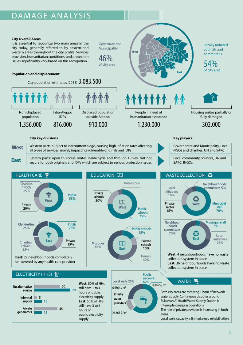
City Overall Areas It is essential to recognize two main areas in the city today, generally referred to by eastern and western areas throughout the city profile. Services provision, humanitarian conditions, and protection issues significantly vary based on this recognition
Governate andMunicipality
46%of city area
Locally initiatedcouncils andcommittees
54%of city area
West: 4 neighbourhoods have no wastecollection system in placeEast: 36 neighbourhoods have no wastecollection system in place
East: 22 neighbourhoods completelyun-covered by any health care provider
West: 80% of HHs still have 1 to 4 hours of public electricity supplyEast: 55% of HHs still have 3 to 6 hours ofpublic electricity supply
Both city areas are receiving 1 hour of network water supply. Continuous disputes around Sulaiman Al Halabi Water Supply Station is interrupting regular operations.The role of private providers is increasing in both areas.Local wells capacity is limited, need rehabilitation.
Population and displacement
Non-displaced population
1.356.000
Intra-Aleppo IDPs
816.000
Displaced population outside Aleppo
910.000
People in need of humanitarian assistance
1.230.000
Housing unites partially or fully damaged
302.000
City population estimates (2011) 3.083.500
City key divisions
Western parts: subject to intermittent siege, causing high inflation rates affecting all types of services, mainly impacting vulnerable originals and IDPs
Eastern parts: open to access routes inside Syria and through Turkey, but not secure for both originals and IDPs which are subject to serious protection issues
Key players
Governorate and Municipality, Local NGOs and charities, UN and SARC
Local community councils, UN and SARC, INGOs
HEALTH CARE EDUCATION WASTE COLLECTION
WATER
ELECTRICITY (HHS)
Private water providers
4

CITY PROFILE OF ALEPPO | MAY 2014
Draft for
revision and endorsment
G O V E R N O R AT E CO N T E X TMAP 1: CITY OF ALEPPO WITHIN GOVERNORATE CONTEXT
• Aleppo is the largest Governorate in Syria in terms of population (4.68 million, CBS, 2011). The city of Aleppo is the central city in the Governorate.
• Aleppo Governorate has 8 districts. Jabal Sama’an is the largest district in terms of population as the central city of the district is Aleppo.
• The urban population was 55% of the total Governorate population in 2011
• Aleppo Governorate had a dominant economic role at the national level. Main economic drivers in the Governorate were agriculture, tourism, and industry
• Currently; the Governorate is one of the mostly impacted amongst all Governorates.
1. 1.73 million inhabitants are currently displaced, either within cities or between cities and rural areas, representing 35% of the Governorate population
2. 1 million inhabitants have completely fled the Governorate, almost 90% of whom are from the city of Aleppo itself. Main displacement destinations are the Syrian coastal Governorates (Lattakia and Tartous), GAP Region (Turkey), Egypt, Lebanon and Arabian Gulf.
3. Jabal Sama’an IDPs (i.e. IDPs within Aleppo) make 15% of total Syria IDPs, and 26% of Syria’s urban IDPs. Jabal Sama’an people in need (PiN) comprises 14% of PiN in Syria (Figure1)
Figure 1: IDPs and people in need in Aleppo Governorate (OCHA, Syria 2013)Governorate: Aleppo
Municipality:
Central city of Aleppo Governorate
Number of
neighbourhoods: 125
Number of informal settlements:
22
City Importance: One of the world’s oldest habitats, rich
in cultural heritage, with extensive urban economic, social and institutional capital.
T U R K E Y
H a m a
I dl i b
Al-Etehad
Al-Khalij
Ebla
Mamoun
Mamoun
ALEPPO
IDLIB
To RAQA
JaboulSalt-Lake
Assad Lake
K u a i k Ri v
er
Euphrate
s Riv
er
GAZI AINTEP
ADANA
MARSEN
Manbj
Al-Bab
A’zaz
Tal Refa’at
MareaAfreen
Jandarees
Al-Atareb
Al-Zurba
Al- Hader
Al- Sfera
Khanser
Al-Hajeb
Der Hafer
Al-Khafseh
Maskaneh
Jarablous
Al- Ra’ee
Ayn Arab
Manbj
Al-Bab
A’zaz
Tal Refa’at
MareaAfreen
Jandarees
Darat Ezza
Al-Atareb
Al-Zurba
Al- Hader
Al- Sfera
Khanser
Al-Hajeb
Der Hafer
Al-Khafseh
Maskaneh
Jarablous
Al- Ra’ee
Ayn Arab
26% of Aleppo city IDPs (Camps, Turkish cities, Europe)
40% of Aleppo IDPs (coastal region cities)
9% of Aleppo city IDPs
(Kurdish area of Afreen)
25% of Aleppo city IDPs (secondary cities and
rural areas)
Governorate boundaryDistrict boundaryRiverLakeWater withdrawal pipelineRoadRailroadAirport
City of Aleppo
Central city
Major urban settlement (proportional to population)Gateway UniversityWorld Heritage SiteThermal/ hydrologic electricity plantIDPs campConcentration of IDPs from the city of Aleppo
Active supply route
Trends of IDPs �eeing Aleppo
0 30 40 km
5
Draft for
revision and endorsment
Draft for
revision and endorsment
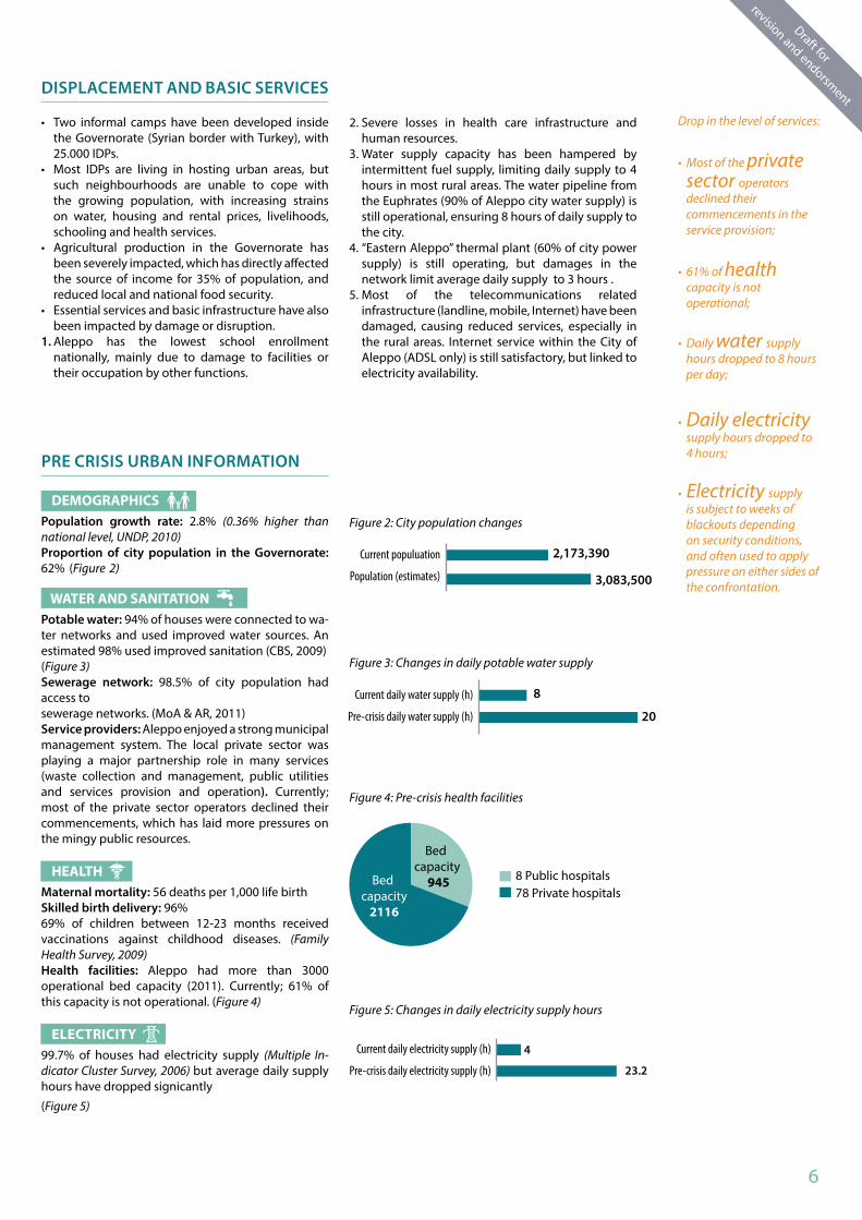
Drop in the level of services:
• Most of the private sector operators declined their commencements in the service provision;
• 61% of health capacity is not operational;
• Daily water supply hours dropped to 8 hours per day;
• Daily electricity supply hours dropped to 4 hours;
• Electricity supply is subject to weeks of blackouts depending on security conditions, and often used to apply pressure on either sides of the confrontation.
DISPLACEMENT AND BASIC SERVICES
• Two informal camps have been developed inside the Governorate (Syrian border with Turkey), with 25.000 IDPs.
• Most IDPs are living in hosting urban areas, but such neighbourhoods are unable to cope with the growing population, with increasing strains on water, housing and rental prices, livelihoods, schooling and health services.
• Agricultural production in the Governorate has been severely impacted, which has directly affected the source of income for 35% of population, and reduced local and national food security.
• Essential services and basic infrastructure have also been impacted by damage or disruption.
1. Aleppo has the lowest school enrollment nationally, mainly due to damage to facilities or their occupation by other functions.
PRE CRISIS URBAN INFORMATION
DEMOGRAPHICSPopulation growth rate: 2.8% (0.36% higher than national level, UNDP, 2010)Proportion of city population in the Governorate: 62% (Figure 2)
WATER AND SANITATIONPotable water: 94% of houses were connected to wa-ter networks and used improved water sources. An estimated 98% used improved sanitation (CBS, 2009)(Figure 3)Sewerage network: 98.5% of city population had access tosewerage networks. (MoA & AR, 2011)Service providers: Aleppo enjoyed a strong municipal management system. The local private sector was playing a major partnership role in many services (waste collection and management, public utilities and services provision and operation). Currently; most of the private sector operators declined their commencements, which has laid more pressures on the mingy public resources.
HEALTHMaternal mortality: 56 deaths per 1,000 life birthSkilled birth delivery: 96%69% of children between 12-23 months received vaccinations against childhood diseases. (Family Health Survey, 2009)Health facilities: Aleppo had more than 3000 operational bed capacity (2011). Currently; 61% of this capacity is not operational. (Figure 4)
ELECTRICITY99.7% of houses had electricity supply (Multiple In-dicator Cluster Survey, 2006) but average daily supply hours have dropped signicantly
(Figure 5)
2. Severe losses in health care infrastructure and human resources.
3. Water supply capacity has been hampered by intermittent fuel supply, limiting daily supply to 4 hours in most rural areas. The water pipeline from the Euphrates (90% of Aleppo city water supply) is still operational, ensuring 8 hours of daily supply to the city.
4. “Eastern Aleppo” thermal plant (60% of city power supply) is still operating, but damages in the network limit average daily supply to 3 hours .
5. Most of the telecommunications related infrastructure (landline, mobile, Internet) have been damaged, causing reduced services, especially in the rural areas. Internet service within the City of Aleppo (ADSL only) is still satisfactory, but linked to electricity availability.
Figure 2: City population changes
Current populuation
Population (estimates)
Figure 3: Changes in daily potable water supply
Current daily water supply (h)
Pre-crisis daily water supply (h)
Current daily electricity supply (h)
Pre-crisis daily electricity supply (h)
Figure 5: Changes in daily electricity supply hours
Figure 4: Pre-crisis health facilities
8 Public hospitals78 Private hospitals
6

CITY PROFILE OF ALEPPO | MAY 2014
Draft for
revision and endorsment
Figure 6: Operational school facilities
EDUCATION97.5% of 6 – 11 year-olds were in school, but the drop-outrate exceeded 9.5% (CBS, 2011)Illiteracy rate (15+): 20.2%.Number of primary schools: public: 3.300, private: 72, UNRWA: 11(CBS, 2010). Current-ly 34% of these facilities are not operational (Figure 6)
ECONOMY
Key economic drivers: Private sector led industrial activity, international tourism based on cultural heritage, commerce.Strategic role and key linkages: the dominant city in northern Syria, linking coastal cities with the eastern region, and playing a pivotal role in transportation between the Arab Gulf, Syria and Europe.Pre-crisis unemployment rate: 7.6% (CBS, 2011)Estimated current unemployment rate: 73.8% Industry, tourism and construction used to be the city main sectors of employment (Figure 7). The major current losses in employment are in the tourism, industry, services and construction sectors (Figure 8).
HOUSING AND SHELTER• Aleppo had 720.000 housing units in 2011
(Figure 11), 64% of which were in the form of multi-storey apartment buildings, with another 10% of Patio Houses (old city and traditional neighbourhoods) (Figure 9). The 22 informal housing areas provided 45% of the housing stock.
• 86% of the households in Aleppo were owners. Of these, 61% had official ownership titles only, while the remaining possessed some form of documentation approved by the official notary bureau. 10.5% of households were renting. (Figure 10).
• As per the findings of the city profile, 302,000 housing units are no longer in use or have been abandoned (end 2013), i.e. 52% of the city 2011 housing stock .
• The majority of the damaged residential units are multi-storey. The concentration of damage in the informal areas may lead to complex tenure issues in future recovery.
Currently operative schools (Dec. 2013)
Nonoperative schools
Figure 7: Pre-crisis employment per sector
IndustryHotels and restaurantsConstructionServices (including government staff) Transportation and communicationsFinance, insurance, and real estateAgriculture and forestry
Figure 8: Changes in emplyment rate per sector
IndustryHotels and restaurants
ConstructionServices (including government staff)
Transportation and communicationsFinance, insurance, and real estate
Agriculture and forestry
Figure 9: Residential buildings typologies
VillaMulti-storyPatio houseRow houses
Figure10: Destribution of owners per ownership types
Official ownershipInformal on agricultural propoertyNotary registered deedSquatting
Figuer 11: Number of housing units in Aleppo 2013 - 2011 (CBS, 2011)
No. of housing units
No. of occupied units
No. of empty units
No. of units under construction
No. of units out of use
7
Draft for
revision and endorsment
Draft for
revision and endorsment
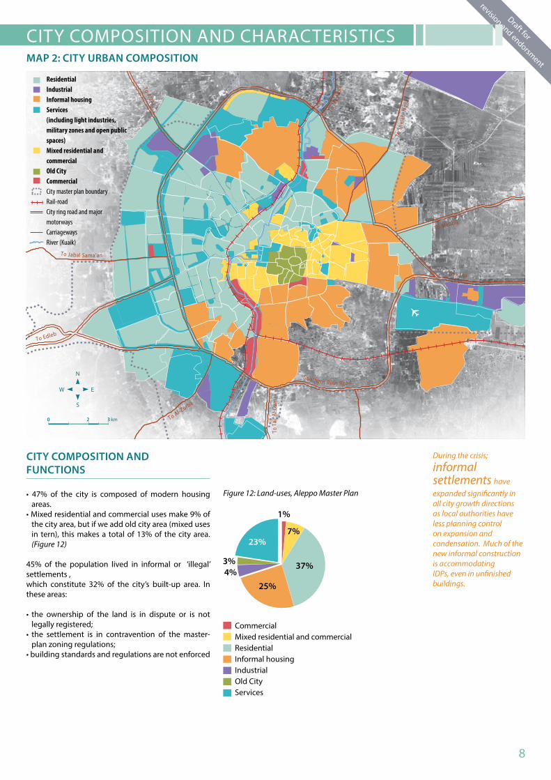
CITY COMPOSITION AND CHARACTERISTICS MAP 2: CITY URBAN COMPOSITION
During the crisis;
informal settlements have expanded significantly in all city growth directions as local authorities have less planning control on expansion and condensation. Much of the new informal construction is accommodating IDPs, even in unfinished buildings.
CITY COMPOSITION ANDFUNCTIONS
• 47% of the city is composed of modern housing areas.
• Mixed residential and commercial uses make 9% of the city area, but if we add old city area (mixed uses in tern), this makes a total of 13% of the city area. (Figure 12)
45% of the population lived in informal or ‘illegal’ settlements ,which constitute 32% of the city’s built-up area. In these areas:
• the ownership of the land is in dispute or is not legally registered;
• the settlement is in contravention of the master-plan zoning regulations;
• building standards and regulations are not enforced
ResidentialIndustrialInformal housingServices (including light industries, military zones and open public spaces)Mixed residential and commercialOld CityCommercialCity master plan boundaryRail-roadCity ring road and major motorwaysCarriagewaysRiver (Kuaik)
Southern Ring Road
To Menbij
To Jabal Sama’an
To A’zaz
To Mes
lmia
To S
heik
h N
ajja
r
To Edleb
To Al-Zurba
To T
al A
l-Dam
anTo Raqa
0 2 3 km
Figure 12: Land-uses, Aleppo Master Plan
CommercialMixed residential and commercialResidentialInformal housingIndustrialOld CityServices
8

CITY PROFILE OF ALEPPO | MAY 2014
Draft for
revision and endorsment
DAMAGES OF BUILDINGS ANDHOUSING STOCK
In terms of area damage; the profile concludes that:(Map 3, Figure 13)
20 neighbourhoods have been heavily damaged (most to all buildings are either damaged or structurally hazardous);
61neighbourhoods have been partially damaged (heavy damages limited to certain areas/ blocks. Other buildings are still habitable or have been repaired)
44 neighbourhoods have no damage or minor damage.
DAMAGES AS PER CITY LAND USE COMPOSITION When damage was considered against spatial functions, the RCP concluded that the housing urban function has received the biggest share of damages; (Figures 14 and 15 )• 78% of the damaged areas (both heavily and
partially) were residential, mostly multi-storey housing buildings
• 67% of the heavily damaged were informal housing areas. (Figure 16)
• Commercial and industral areas have also been affected by damage which has caused loss of livelihoods and income.
• 71% of the industrial areas have been partially damaged. This does not include the damage in the Industrial City of Sheikh Najjar (also partially damaged) since the area is not inside the master plan area accounted for in Figure 14 and 15
AFFECTED POPULATION PER DAMAGES OF HOUSING
• 2.25 million of Aleppo’s population have been se-verely affected by the damages of housing and buildings stock. 0.96 million have not been directly affected.
• It is estimated that 1.2 million inhabitants have been forced to leave their homes due to severe housing damages; most of which were concentrated in the informal housing areas, the old city, and the traditional high density neighbourhoods surrounding the old city. (Figure 17)
C I T Y DA M AG E A N A LY S I SMAP 3: DAMAGE ANALYSIS
Since January 2014, a new cycle of escalation has occurred in a number of neighbourhoods referenced in Map 3.
67% of heavy damages are in informal settlements
Sheikh Najjar Industrial City
0 2 3 km
Heavily DamagedPartially DamagedA�ected
recently escalating neighbourhood City master plan boundaryOld City boundaryInformal AreasRail-roadCity ring road andmajor motorwaysCarriagewaysRiver (Kuaik)
Southern Ring Road
To Menbij
To Jabal Sama’an
To A’zaz
To Mes
lmia
To S
heik
h N
ajja
r
To Edleb
To Al-Zurba
To T
al A
l-Dam
anTo Raqa
Hanano
As-Sukk
ari
Al- Sha’ar
Karm Myassar
Karm Al Qaterji
9

Draft for
revision and endorsment
Draft for
revision and endorsment
2.25 million of Aleppo’s population have been severely affected by the damages of housing and buildings stock
1.2 million inhabitants have beenforced to leave their homes due to severe housing damages
The increased proportion of population affected by the damage in the
housing sector can be attributed to the concentration of heavy damage in high-density residential areas
• Some inhabitants have chosen to stay in partially damaged houses, and sometimes in structurally hazardous conditions, especially the elderly who are emotionally attached to their homes, or low-income groups who could not afford displacement “costs”, representing a major shelter- vulnerability issue.
The increased proportion of population affected by the damage in the housing sector (when compared to proportional area of damage) can be attributed to the concentration of heavy damage in high-density residential areas (mainly the informal settlements). The following map shows the pre-crisis population densities in the city neighbourhoods, which signals the implications of housing damage. (Figure 18)
Figuer 15: Landuse Vs. damage level, Aleppo
Figure 13: Neighbourhoods per damage level
Figure 17: Affected population per housing damage level (for total city population)
Figure 18: Population Density in the city (pre-crisis, Capita/ha)
Figure 16: Distribution of heavy damage per land-use
Figure 14: Damage level Vs. urban land-uses (%), Aleppo, Dec. 2013
Heavily damaged buildings in Aleppo 2013
Heavily DamagedPartially DamagedAffected
Heavily DamagedPartially DamagedAffected
ResidentialIndustrialInformal housing
Mixed residential and commercialOld City
Commercial
ResidentialInformal housingServices Mixed residential and commercialOld City
No populationless that 40110-40200-110300-200More than 300
Heavily DamagedPartially DamagedAffected
Informal Area
Public Services
Old City
Industrial
Residential
ResidentialCommercial
Commercial
Affected
Partially Damaged
Heavily Damaged
10
CITY PROFILE OF ALEPPO | MAY 2014
Draft for
revision and endorsment
Al-Maji
Al-Hazzazeh
Bayada
Tatrlar
Al-Ballat
Ad-D
udu
Abra
j
QarleqAd-DallainIbn
Ya’aqoub
Muhamad Bek
Al-Tunbogha
Aghyol
Al-Farafra
Al-Madinaold soup
Al-Aqabeh
AleppoCitadel
Al-A’ajam
Qa’aletAl-S
harifSahet B
izzeh
Al-Asile
h
Sajilikhan
Al-Jalloum
Qastal Mosht
Beit Meheb / Jdeydeh
Qadi Askar
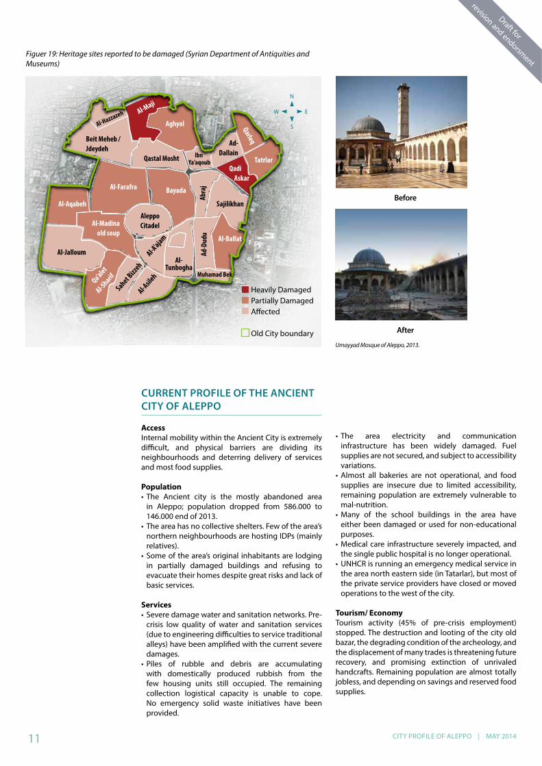
Figuer 19: Heritage sites reported to be damaged (Syrian Department of Antiquities and Museums)
CURRENT PROFILE OF THE ANCIENT CITY OF ALEPPO
Access Internal mobility within the Ancient City is extremely difficult, and physical barriers are dividing its neighbourhoods and deterring delivery of services and most food supplies.
Population• The Ancient city is the mostly abandoned area
in Aleppo; population dropped from 586.000 to 146.000 end of 2013.
• The area has no collective shelters. Few of the area’s northern neighbourhoods are hosting IDPs (mainly relatives).
• Some of the area’s original inhabitants are lodging in partially damaged buildings and refusing to evacuate their homes despite great risks and lack of basic services.
Services• Severe damage water and sanitation networks. Pre-
crisis low quality of water and sanitation services (due to engineering difficulties to service traditional alleys) have been amplified with the current severe damages.
• Piles of rubble and debris are accumulating with domestically produced rubbish from the few housing units still occupied. The remaining collection logistical capacity is unable to cope. No emergency solid waste initiatives have been provided.
• The area electricity and communication infrastructure has been widely damaged. Fuel supplies are not secured, and subject to accessibility variations.
• Almost all bakeries are not operational, and food supplies are insecure due to limited accessibility, remaining population are extremely vulnerable to mal-nutrition.
• Many of the school buildings in the area have either been damaged or used for non-educational purposes.
• Medical care infrastructure severely impacted, and the single public hospital is no longer operational.
• UNHCR is running an emergency medical service in the area north eastern side (in Tatarlar), but most of the private service providers have closed or moved operations to the west of the city.
Tourism/ EconomyTourism activity (45% of pre-crisis employment) stopped. The destruction and looting of the city old bazar, the degrading condition of the archeology, and the displacement of many trades is threatening future recovery, and promising extinction of unrivaled handcrafts. Remaining population are almost totally jobless, and depending on savings and reserved food supplies.
Umayyad Mosque of Aleppo, 2013.
Before
After
Heavily DamagedPartially DamagedAffected
Old City boundary
11

Draft for
revision and endorsment
Draft for
revision and endorsment
• In September 2012, a blaze swept through the Ancient Souk (medieval covered market) after clashes in the vicinity, while in April 2013 the Great Mosque’s 11th Century minaret was reduced to rubble. (photographs below)
• Another 121 cultural assets (houses, mosques, churches, Khans, markets and open spaces monuments) have been reported as damaged (totally or partially destroyed, burned, or looted). However, it is estimated that the damages in cultural assets are under reported, as many neighbourhoods in the Ancient City of Aleppo are currently not accessible. (Figure 19)
• Nearly 80% of the old city population have fled from the old centre, mainly to western part of Aleppo. Shops are either burned or looted, and most of the city services and infrastructure have been damaged.
THE IMPACT ON THE OLD CITY OF ALEPPO
Damage in the archeological heritage of Aleppo Ancient City
12

CITY PROFILE OF ALEPPO | MAY 2014
Draft for
revision and endorsment
U R B A N F U N C T I O N A L I T YMAP 4: CURRENT LEVEL OF FUNCTIONALITY
Functionality analysis for the city found that there is not a direct link between damages to housing and habitability and functionality levels. People occupy damaged areas due to a range of factors including extreme vulnerability and inability to pay rents elsewhere, risk of losing property, minimum critical
infrastructure and services and livelihoods. These factors together form revival of critical functionals in Aleppo neighbourhoods. (Map 4)
21 neighbourhoods were found not functional, and were effectively de-populated. These were previously high population density areas.
53 neighbourhoods were partially functional, either retaining part of original population or attracting very vulnerable IDPs from heavily damaged areas. These IDPs are being hosted by families, friends and relatives and cannot leave due to resource, property or cash constraints;
40 neighbourhoods were functional, but affected by influx of IDPs from all the other neighbourhoods.
It was also noted that neighbourhoods are clustering in patterns in terms of functionality.
28% of Aleppo urban area is no longer functional
Out of 125 neighbourhoods,
74 neighbourhoods are either not functional or only partially functional
0 2 3 km
Not FunctionalPartially FunctionalA�ected Functionality
City master plan boundaryRail-roadCity ring road and major motorwaysCarriagewaysAccessible supply routesCross pointRiver (Kuaik)In-crisis emerging marketOperational marketIn-operational marketFruit and vegetable wholesale market
Southern Ring Road
To Menbij
To Jabal Sama’an
To A’zaz
To Mes
lmia
To S
heik
h N
ajja
r
To Edleb
To Al-Zurba
To T
al A
l-Dam
anTo Raqa
Figure 20: Classification of neighbourhood per urban functionality
URBAN FUNCTIONALITY LEVELS
Housing facilities
Basicinfrastr-ucture
Basic services
Markets
Not Functional
Most houses are either damaged or structurally hazardous
Not operational
No services
Not functioning
Partially Functional
Total damages limited to certain blocks, others are still hapitable
Partially operational for some areas/ sectors
Limited services
Partially functional
Affected Functionality
Minor to no damages
Affected due to strain on infrastructure and services due to increased IDP population
Available services
Functioning. New markets established
13

Draft for
revision and endorsment
Draft for
revision and endorsment
4
IMPACT ON INFRASTRUCTURE AND SERVICES
ACCESSIBILITY
1. Road accessibility• Humanitarian access from Damascus to Aleppo has been seriously affected since July 2013, travel and transportation of assistance to Aleppo remains a challenge. Eastern and southern parts of the city are still accessible through international road connections, linking the area to rural areas, and to eastern Syria.
• Western parts of the city are under intermittent blockade, and have two limited-access routes (single carriage roads); (1) through Khanaser, Safeera, then align Aleppo International Airport , or (2) through Al Zerbeh, Khan Touman and leading to Bustan Al-Qaser cross point.
2. Airport and railroads• Aleppo airport has been closed since December
2012 and no operations have taken place. Some damages have been reported in the runway.
• Aleppo population use Lattakia and Damascus airports or travel through Turkey.
• Rail roads have not been operational since February 2012
• Substantial damages and thefts have been reported regarding rail-roads infrastructure and assets.
3. Cross-point at Bustan Al Qaser• Only one cross-point links western and eastern parts
of Aleppo. Massive daily population movements (strictly pedestrian) are observed at the cross-point, but it is often closed when clashes intensify or open for few hours a day.
• Thousands of employees cross through this cross-point on a daily basis, and large markets have developed on the eastern side of it, where thousands of people from the western parts can seek less expensive daily commodities, but are only allowed to carry in small quantities.
4. Public transportation• The pre-crisis public transportation system has
collapsed, except for limited microbus service in the western city parts
• Most formal taxi services have stopped, which led private cars owners to operate as an alternative service
• The cost of transportation has increased five fold since early 2013 due to increases in fuel/gasoline prices. In January 2014 the gasoline price was 1300 Syrian Pound per liter.
ELECTRICITY AND FUEL
• The Eastern Aleppo thermal plant (originally 60% of city power supply) is still operating under conflict contexts, and most urban and rural areas are supplied at average of 4 hours per day.
• Lack of electricity supply is a major factor in the deterioration of basic services. Private generators have become widespread in the west part of Aleppo.
• Prices of the main fuel materials can vary according to city accessibility, changes in the market demand per season, or availability of informal fuel. However, prices are usually less expensive in the eastern parts of the city, as the locally refined fuel is common in those areas with full access to sources of partially processed fuel in Syria’s eastern regions. (Figure 21)
1 Nov. 1 Dec. 1 Jan. 1 Feb.
%age of increase as compared to reference price
% a
ge o
f inc
reas
e as
com
pare
d to
re
fere
nce
pric
e
Figure 21: Consumer prices of fuel commodities
Supply chains of
basic goods and services are directly linked to accessibility.
Recent clashes on the southern ring road of the city (Al Ramouseh Area) has caused full
inaccessibility to western Aleppo; this has instantly minimized the offer of goods and services in the west, causing massive inflation of fresh food and fuel materials prices.
Continued access to
eastern part of Aleppo is facilitating trade between the city and the rural areas, and with Turkey for imported goods.
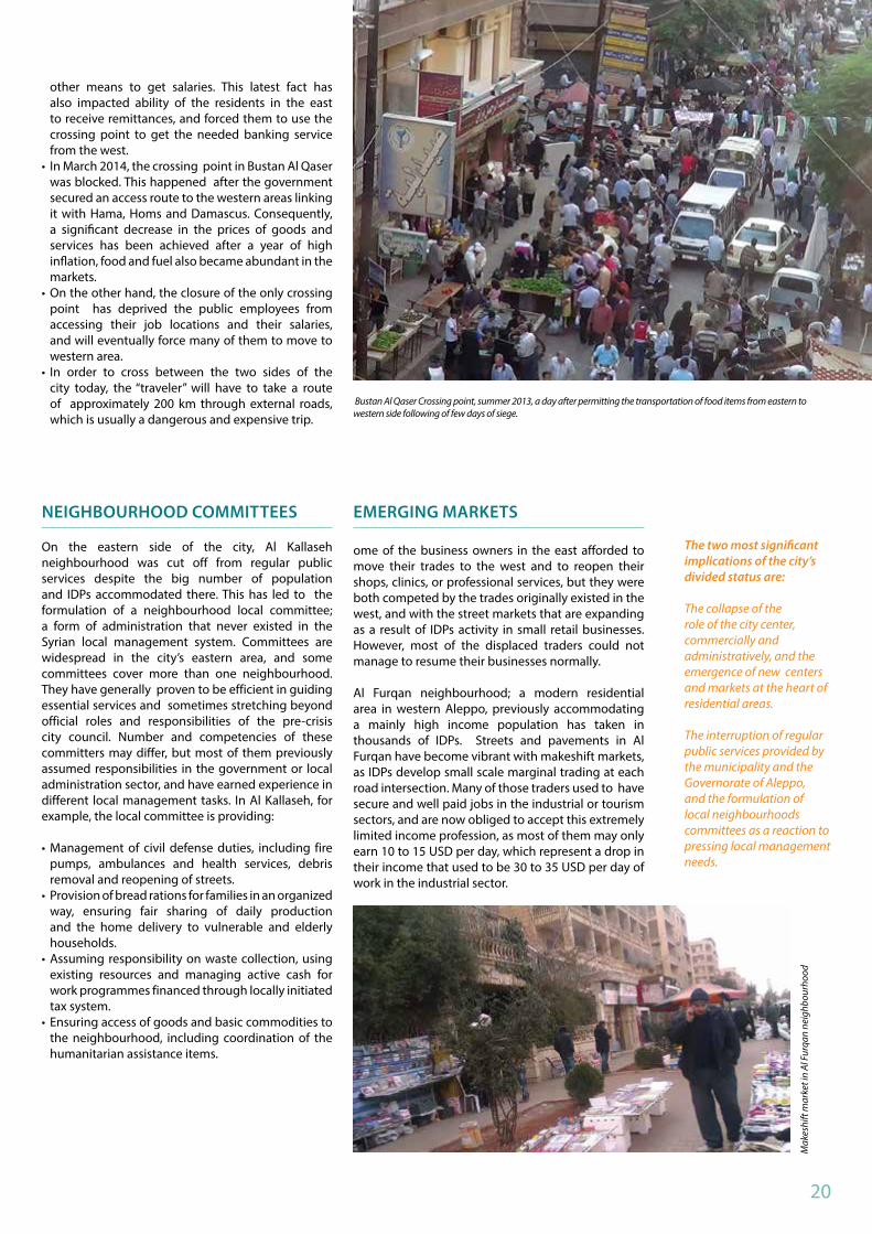
Bustan Al-Kaser cross-point, Summer 2013.
FOOD AND LIVELIHOODS
1. FoodAlthough food is largely available in the markets, it is still the most urgent issue for most families in Aleppo. Changes in the prices, lack of cooking fuel, and disruption of livelihoods are making food inaccessible, and despite the fact that there are no evident problems of starvation, many areas are at risk (eg: Makar Al Anbia’a, Al Sha’ar, Hanono, and Ain Al Tal). Food prices vary on both sides of the cross-point. Prices are generally higher in the west due to intermittent cut offs in supply but original residents are of higher income groups and can manage unlike IDPs in the area who are impacted more and may need to prioritize children and vulnerable family members in the limited meals they can afford. (Figure 22).
1 Nov. 1 Dec. 1 Jan. 1 Feb.
Figure 24: Consumer prices of food items.
14

CITY PROFILE OF ALEPPO | MAY 2014
Draft for
revision and endorsment2. LivelihoodThe loss of livelihood activity is attributed to many factors:• The collapse of the industrial and construction
sectors that used to be the largest economic drivers• The slowed commercial relations with Turkey. • The collapse of the role of the Ancient city of Aleppo
as a major commercial and tourism hub• The degradation of the agricultural sector in the
Governorate that used to produce 35% of the country food needs
• Lack of fuel supplies and the prevailing security and accessibility limitations.
3. Emerging skills• The collapse of many traditional markets, and
the shift in population densities have led to the emergence of new informal markets, mostly led by IDPs though micro investments (Map 4).
• The transportation sector has become a major sector of employment; with the collapse of pre-crisis public transportation system, many private cars operators are providing an alternative mode.
• The formal construction business has stopped, but minor repairing trades are still active (electricity and water repairs, debris removal and re-opening of streets, installation of basic materials in unfinished or partially damaged building) (Figure 23)
Operative schools without DoE supervision
Operative schools under DoE
Currently operative schools (Dec. 2013)
Collective shelters (Dec. 2013)
Nonfunctional school buildings (eastern part)Nonfunctional school
buildings (western part)
Nonoperative schools
Total Number of schools (2011)
Figure 24 : School Facilities Operations
Agricultural production in rural Aleppo used to provide %35 of the country food needs. Currently, agricultural production is interrupted, including processing industries located in the city industrial sites.
Leishmaniasis,
scab and lice are affecting almost all city areas
%34 of schools are no longer operational due to direct damage
EDUCATION
• 34% of schools are no longer operational due to direct damage, these schools now require rehabilitation. Occupation of schools by collective shelters and other uses has also limited available facilities, as no other shelter options were explored. (Figure 24)
• The Governorate of Aleppo recently led efforts to empty 60 schools of IDPs and to restore them into the educational function (together with Aleppo University dormitory), but recent influx of IDPs from
Sayf Ad-Dauleh, As Sukkari and Salah Ad-Deen has forced local authorities to reoccupy these spaces for emergency shelter purposes.
• Attendance rates in Aleppo are estimated to be the low given the different factors interrupting regular education process
• The main reasons for drop-out are fear and accessibility, lack of facilities and educational materials.
• Almost all schools in Aleppo are working in double shifts, but in the eastern parts of the city, most schools are working in triple shifts.
Figure 25: Current sectors of employment
Figuer 27: Operational Status of public health facilities
Industry and lightcraftsConstruction and building repairsTransportationPublic servicesCommerce
HEALTH AND NUTRITION
• There has been a significant drop in the city’s operational public hospitals (by 61%). All operatiional public and private hospitals are in the western parts of the city (Figure 25). Lack of facilities is an issue for neighbourhoods attracting IDPs: Midan, Sayf Ad-Dauleh, and As Sukarri. The eastern periphery of the city is the least served area in terms of health services.
• Some of the areas of concentrated damage used to accommodate a big number of private clinics and pharmacies (Seif Al-Dawla, Al-Ashraa, and Al-Sha’ar), which are currently inoperative as practitioners had to close or move.
• Various types of diseases and epidemics have become widespread in the city: leishmaniasis in the western neighbourhoods resulting from un-collected garbage, scab and lice are affecting almost all city areas, mainly at schools and in IDPs agglomerations.
• 70% of Aleppo’s pharmaceutical industry has stopped, and lack of access routes are making medicine not accessible for most of the vulnerable population.
Damage school in Aleppo
Operative bed capacityNot operative bed capacity
15

Draft for
revision and endorsment
Draft for
revision and endorsment
Ash-SheikhMaqsoud
Industrial Site Of Sheikh NajjarAl Ashra�yeh
Ar-Ramouseh
Blleramoon
Jabal Badro
Jibreen
FUNCTIONALITY OF THE INDUSTRIAL SECTOR
The crisis impact on the industrial sector is a major factor in the deterioration of city livelihoods. The Syrian Labourers Union reported that around 140.000 labourers have been laid off from the sector by December 2013.
1. The greatest industrial losses are concentrated in Syria largest industrial site of Sheikh Najjar (4.412 ha, north east of Aleppo), where there has been a signicant drop in the operational capacity (Figure 27).
2. Textile and garment industries have almost collapsed in Ash-Sheikh Maqsoud and Al Ashrayeh, and all traditional crafts in the Ancient City of Aleppo have closed down. Medical and building materials industry located near the Aleppo-Damascus highway are partially operational, but major industrial clusters in Ar-Ramouseh and Blleramoon have been widely damaged.
3. Informal industrial areas have also reduced operations due to direct damage to buildings andinfrastructure (Jibreen and Jabal Badro in specific). (Figure 28).
Figure 27: Decrease in Sheikh Najjar industrial site operations
Figure 28: Essential industrial areas
WATER AND SANITATION
Despite the operational status of the channel from the Euphrates (90% of city needs), and the quality potable water and sanitation network the city previously enjoyed, there has been a serious decrease in the level of the services in most of the city due to• Insecure supplies of pumping fuel, and the deficiency
in the water supply institutional system• Damages in the water and sanitation networks
infrastructure are limited to some areas only, but some of the key pumping equipments are severely damaged
• The quality of water deteriorated due to a lack of necessary sterilization chemicals,.
• Supply hours dropped from 20 to 8 hours per day• IDPs sheltered in the unfinished buildings are
suffering from lack of water storage means and sanitation facilities.
• Inaccessibility of hygiene items due to inflated prices is disrupting regular hygiene, which used to be a part of the local culture.
SOLID WASTE
Waste management and collection services have become almost non-existent in some areas (mainly in eastern and northern areas), or only continue through the efforts of the people living there.• Informal dumping locations at the fringes of urban
areas are causing enormous hygiene concern (mainly in Hamadaniyeh, Blleramoon, Midan, Al-Sakhour, and Al-A’arqoub); these are ideal breeding grounds for disease and parasites. Some residents also try to dispose of trash by burning it, generating waves of acrid smoke across Aleppo.
• Despite big losses in the garbage collection capacity (Figure 26); collection in western parts of Aleppo has been restored at a cycle of once every two days, despite the regression of private operators, but changes in the population densities and emerging markets are straining the limited capacity.
• Eastern parts of the city have access to dump sites arranged in the urban hinterland, with local management system developed by neighbourhoods communities. The latest clashes in the city eastern parts have deeply impacted such local municipal systems and brought them to a standstill.
• Inaccessibility to Aleppo landfill at Tal Al Daman (43 km, south) may result in hundreds of accumulated piles to continue to exist citywide.
Figure26: Solid waste collection
Estimated in-duty vehicles (2014)
Assessed vehicls need (2004)
Pre-crisis in-duty vehicle (2011)
Estimated in-duty laborersWaste management
laborers needed (2004)Waste management
laborers (2011)
16
CITY PROFILE OF ALEPPO | MAY 2014
Draft for
revision and endorsment
Less than 10% 10 to 50%50 to 100%100 to 150%150 to 200%More than 200%Not residential
Intra-city displacement trend
Master plan boundary
0 2 3 km
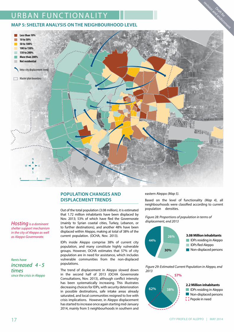
POPULATION CHANGES ANDDISPLACEMENT TRENDS
Out of the total population (3.08 million), it is estimated that 1.72 million inhabitants have been displaced by Nov. 2013; 53% of which have fled the Governorate (mainly to Syrian coastal cities, Turkey, Lebanon, or to further destinations), and another 48% have been displaced within Aleppo, making at total of 38% of the current population. (OCHA, Nov. 2013).
IDPs inside Aleppo comprise 38% of current city population, and many constitute highly vulnerable groups. However, OCHA estimates that 57% of city population are in need for assistance, which includes vulnerable communities from the non-displaced populations.
The trend of displacement in Aleppo slowed down in the second half of 2013 (OCHA Governorate Consultations, Nov. 2013), although conflict intensity has been systematically increasing. This illustrates decreasing choices for IDPs, with security deterioration in possible destinations, safe intake areas already saturated, and local communities resigned to live with crisis implications. However, in Aleppo displacement has started to increase once again starting mid-January 2014, mainly from 5 neighbourhoods in southern and
U R B A N F U N C T I O N A L I T YMAP 5: SHELTER ANALYSIS ON THE NEIGHBOURHOOD LEVEL
eastern Aleppo (Map 5).
Based on the level of functionality (Map 4), all neighbourhoods were classified according to current population densities.
Hosting is a dominant shelter support mechanism in the city of Aleppo as well as Aleppo Governorate.
Rents have
increased 4 - 5 times since the crisis in Aleppo
Figure 28: Proportions of population in terms of displacement, end 2013
3.08 Million inhabitantsIDPs residing in AleppoIDPs fled AleppoNon-displaced persons
Figure 29: Estimated Current Population in Aleppo, end 2013
2.2 Million inhabitantsIDPs residing in AleppoNon-displaced personsPepole in need
17

Draft for
revision and endorsment
Draft for
revision and endorsment
IDPS SHELTER TYPES
Although the majority of IDPs are living inside existing buildings it is estimated that 12% of them currently live in partially damaged buildings, another 14% live in non-residential spaces.
Hosting is a major shelter provider (35%), but it can vary between:1. Families that host relatives, which tend to be
a temporary solution in search for a separate accommodation, Or;
2. Hosting to apartments, offices, and shops in the western area that have been abandoned by high-income families, who agree to host IDPs to assure property protection.
Squatting in empty apartments is also widespread all around the city. Consequent contact or arrangements with the owners is generally mediated by local community leaders.
Almost 37% of IDPs are affording to rent apartments, both in western and in southern city areas. However, most of the families are sharing the rented accommodations. The cost of renting in the western area has increased since the start of the crisis, causing many evictions. An opposite trend can be found in the eastern and southern city areas, where families can find affordable homes to rent: at 25% to 30% less than pre-crisis rent rates.
Collective shelters are accomodating 7% of IDPs, occupying 86 public buildings (mainly schools and university dormitories all located in the western city area). The Governorate of Aleppo evicted IDPs from collective shelters at the end of 2013 to restore school capacity, and relocated the IDPs in a project called 1070, but recent displacements from Al Sukkari and surrounding areas have caused re-occupation of these schools.
Figure 35: Distribution of IDPs per shelter type
• Decrease in the original population of these neighbourhoods
• Negligible IDP numbers
• Minor decrease in the original population of these neighbourhoods
• Substantial influx of IDPs
Figuer 36: Prevalling IDPs shelter types per neighbourhood
RentingHosting Unfinished buildingsPartially damagedMultipl shelter typesIDP number negligible
RentingCollective rentingHosting SquattingUnfinished buildingsPartially damagedCollective shelters
People in need
Current population
Non-displaced persons
IDPs fled Aleppo
IDPs residing in Aleppo
Total displaced population
Population (estimates, 2013)
Figure 30: Estimated population changes, Nov. 2013 Figuer 34: Classification of neighbourhoods per population status
De-populated neighbourhoods,
no IDPs
Neighbourhoods attracting IDPs
current Population (idps and originals/ as compared to pre-crisis population)
Less than %10
10 to %50
50 to %100
100 to %150
150 to %200
More than %200
18
CITY PROFILE OF ALEPPO | MAY 2014
Draft for
revision and endorsmentSTORY OF A DISPLACED FAMILY FROM IDLIB
As soon as clashes started in my home town of Ariha – Idleb, the house I was living in with my wife and three kids was demolished, and we had to move to Aleppo as the safest and closest destination we could resort to. We moved with what survived and what we could carry of our furniture, the estimated value of which was around S.P 150,000. ( 1000 USD)
We have rented a one-bedroom-apartment at As-Sukkary neighbourhood; one of the cheapest areas to live in, for S.P 2,000 to be paid month by month. The landlord raised the rent which reached S.P 5,000 a month. Without any source of income, this was too expensive for our capacity. In addition, by that time, clashes in Aleppo had started and As-Sukkary became one of the hottest spots.
Therefore, we became part of the mass displacement from As-Sukkary, moving to the university dormitory which had been turned into a collective shelter. Shortly after we arrived, there was a fire and we lost all the furniture we had with us.
My wife left me after giving birth to our fourth child. I have tried to work in selling candy for kids in the streets but the police stopped me. With four children, no income and not a single element of decent life, I find myself helpless and powerless.
STORY OF ABDO
Abdo, his wife and seven children are now living in a collective shelter at the university dormitory, he used to live at his own house at the youth housing project in Al Ma’saranyah, next to the international airport highway in Aleppo. “We did not want to leave
THE IMPACT OF DIVISION AND ACCESSIBILITY BETWEEN EASTERN AND WESTERN ALEPPO
After the city was divided into two sides (Sep. 2012), a pedestrian crossing point was established north of Bustan Al Qaser neighbourhood, allowing limited and intermittent movement of people, goods and products
• The western city side has been subject to intermittent blockades since early 2013. This isolation has resulted in massive increase in living costs (three folds increase as compared to eastern rates), and forced many of the area’s residents (and IDPs) to make a daily trip to the eastern side, in order to buy small amounts of household goods and
our house, we stayed there even after it was partially damaged. However, we had to leave in the end, it was fully destroyed and uninhabitable”, Abdo explains. He continues: “it is extremely difficult to find decent accommodation. We had only one option to live in a non-residential basement where my kids’ health was severely affected by humidity and cold”.
Abdo, had originally lost one of his legs in an accident. After the clashes began, he was also shot in his other leg on his way to work and became completely disabled. He and his family are now depending completely on remittances from his and his wife’s brothers in addition to the income from his son’s work as a butcher for a daily S.P 250 allowance.
STORY OF WALD, ARCHITECT
“My hard work paid out through the years; coming from a big family, I managed to study, graduate and develop my career which allowed me to save a good fortune of money. I used my savings to buy an apartment in the Sheikh Maqsoud area which turned in to one of the hottest areas in Aleppo after the clashes began”.
“Due to the conflict, my work circumstances and my daughter having to prepare for her high school exam, led me to send my wife and other two kids to Efrin, our home town, to live with my parents and sisters, while I had to rent an apartment at the Syriac District neighbourhood which monthly costs me half of my salary. My original apartment at Sheikh Maqsoud has been looted with nothing left there. I have lost my over-time job and am now only living on the monthly salary I get from being a public sector employee. I am in my fifties, without any savings, my family is scattered and I have not seen them in months now. The situation seems to be very scary to me right now and helplessness is the only word which can describe it”.
C A S E S T U D I E S F R O M A L E P P O
C H A N G E S I N T H E E CO N O M Y A N D S E R V I C E S P R O V I S I O N
The crisis has had a major impact on mobility within Aleppo. Crossing between east and west Aleppo is currently prohibited (April 2014) resulting in a serious social and economic disconnection. Movement restrictions within each side of the city further complicates the situation.Such restrictions are usually enforced through physical barriers disconnecting road links, and clearly demarcating clashes frontlines.
food feasible to carry from the huge street market that was locally initiated through micro private investments. Many hire a “crosser” pulling a wheeled bag, who is accustomed to the risks of the crossing process.
• Hundreds of public employees also used the crossing point travelling from east to west in order to reach their jobs, which has ensured a continuation of services and salaries, and helped retain functionality in many of the eastern neighbourhoods. This access enabled many people to stay in their areas of origin in the east despite the damage to buildings and infrastructure.
• Some government officials with work places in the east were no longer working but were still receiving salaries from their respective authorities in the west. They had to travel to the west as banks are not functioning in the east and they had no
19
Draft for
revision and endorsment
Draft for
revision and endorsment
EMERGING MARKETS
ome of the business owners in the east afforded to move their trades to the west and to reopen their shops, clinics, or professional services, but they were both competed by the trades originally existed in the west, and with the street markets that are expanding as a result of IDPs activity in small retail businesses. However, most of the displaced traders could not manage to resume their businesses normally.
Al Furqan neighbourhood; a modern residential area in western Aleppo, previously accommodating a mainly high income population has taken in thousands of IDPs. Streets and pavements in Al Furqan have become vibrant with makeshift markets, as IDPs develop small scale marginal trading at each road intersection. Many of those traders used to have secure and well paid jobs in the industrial or tourism sectors, and are now obliged to accept this extremely limited income profession, as most of them may only earn 10 to 15 USD per day, which represent a drop in their income that used to be 30 to 35 USD per day of work in the industrial sector.
The two most significant implications of the city’s divided status are:
The collapse of the role of the city center, commercially and administratively, and the emergence of new centers and markets at the heart of residential areas.
The interruption of regular public services provided by the municipality and the Governorate of Aleppo, and the formulation of local neighbourhoods committees as a reaction to pressing local management needs.
NEIGHBOURHOOD COMMITTEES
On the eastern side of the city, Al Kallaseh neighbourhood was cut off from regular public services despite the big number of population and IDPs accommodated there. This has led to the formulation of a neighbourhood local committee; a form of administration that never existed in the Syrian local management system. Committees are widespread in the city’s eastern area, and some committees cover more than one neighbourhood. They have generally proven to be efficient in guiding essential services and sometimes stretching beyond official roles and responsibilities of the pre-crisis city council. Number and competencies of these committers may differ, but most of them previously assumed responsibilities in the government or local administration sector, and have earned experience in different local management tasks. In Al Kallaseh, for example, the local committee is providing:
• Management of civil defense duties, including fire pumps, ambulances and health services, debris removal and reopening of streets.
• Provision of bread rations for families in an organized way, ensuring fair sharing of daily production and the home delivery to vulnerable and elderly households.
• Assuming responsibility on waste collection, using existing resources and managing active cash for work programmes financed through locally initiated tax system.
• Ensuring access of goods and basic commodities to the neighbourhood, including coordination of the humanitarian assistance items.
other means to get salaries. This latest fact has also impacted ability of the residents in the east to receive remittances, and forced them to use the crossing point to get the needed banking service from the west.
• In March 2014, the crossing point in Bustan Al Qaser was blocked. This happened after the government secured an access route to the western areas linking it with Hama, Homs and Damascus. Consequently, a significant decrease in the prices of goods and services has been achieved after a year of high inflation, food and fuel also became abundant in the markets.
• On the other hand, the closure of the only crossing point has deprived the public employees from accessing their job locations and their salaries, and will eventually force many of them to move to western area.
• In order to cross between the two sides of the city today, the “traveler” will have to take a route of approximately 200 km through external roads, which is usually a dangerous and expensive trip.
Mak
eshi
ft m
arke
t in
Al F
urqa
n ne
ighb
ourh
ood
Bustan Al Qaser Crossing point, summer 2013, a day after permitting the transportation of food items from eastern to western side following of few days of siege.
20

CITY PROFILE OF ALEPPO | MAY 2014
Draft for
revision and endorsment
AE
B
C
D
WEST EAST
N E I G H B O U R H O O D S A N A LY S I S A N D K E Y F I N D I N G SMAP 6: NEIGHBOURHOODS ANALYSIS FOR ALEPPO
AREA A .Hosting and IDPs attracting neighbourhoods
AREA B.Partially abandoned area but attractive for trade and markets
AREA C.Hosting area for the most vulnerable and low-income IDPs
AREA D. Mostly abandoned and militarized neighbourhoods
AREA E.Depopulated area with highest level of damage
21
699.971
938.000
484.000\
Upper-income
Affected/minor damages
Functional
Hosting, renting or squatting in buildings
220 USD
2 to 3 hours/ day
AREA: A
535.653
416.000
121.000
Middle-income
Partially damaged
Partially Functional
Hosting, renting or lodging to partially damaged buildings
120 USD
4 hours/ day
AREA: B
378.292
346.000
81.000
Low-income
Partially damaged
Partially Functional
Unfinished buildings and rental accommodations
55 USD
4 hours/ day
AREA: C
586.237
128.000
39.000
Upper middle-income
Heavily damaged
Not functionalMany vulnerable original population lodging to partially damaged buildings
2-1 hours/ day
AREA: D
883.344
382.000
88.000
Middle-income
Heavily damaged
Not functional, partial functionality in limited areas
De-populated area with totally abandoned neighbourhoods
4 hours/ day
AREA: ELow density modern housing area
Very high density mixed residential and commercial area
Low density informal housing area Original population
The Ancient Old Historic City and the traditional surrounding Original population
Medium density residential areas, large industrial clusters
Urban Description
Pop. 2011
Current Pop. 2014
Number of IDPs
Income level
Damage level
Level of functionality
Predominant shelter types
Average monthly rent
Electricity supply

Draft for
revision and endorsment
Draft for
revision and endorsment
Area Profile: MOSTLY ABANDONED AND MILITARIZED NEIGHBOURHOODS
• Critical infrastructure damaged: health, water, sanitation, waste collection, bakeries and archeology. Debris and waste are mixed, further challenging separation and disposal.
• All bakeries are not operational and food supply is heavily affected due to limited accessibility
• Limited Governorate and Municipality service provision operations• Current livelihood sources: Markets, tourism and professional services
collapsed• Original population which left the area: %85 (the highest in Aleppo)
Area Profile: HOSTING AND IDPS ATTRACTING NEIGHBOURHOODS
• Safe and secure area in the city• Governorate and municipality as main service providers• Infrastructure and services are under strain of IDPs influx due to
increasing IDP population.• Current livelihood sources: Public services, makeshift retail markets,
transportation• Original population which left the area: %35• IDPs intake: the area is hosting %28 of total city IDPs, and %60 of
intra-city IDPs
AREA: A
Area Profile: PARTIALLY ABANDONED AREA BUT ATTRACTIVE FOR TRADE AND MARKETS
• Partially damaged area, but still inhabited by IDPs, host communities and original population
• Only 2 hours/ day of portable water, large quantities of accumulated garbage, disease outbreaks such as diarrhea and skin diseases
• Neighbourhoods committees and private sector are very active as service providers
• Current livelihood sources: Attractive for trades as the area is the only gateway to Area A
• Original population which left the area: %45, one of the highest in Aleppo.
• IDPs intake: the area is hosting %7 of total city IDPs, and %15 of intra-city IDPs
AREA: B
Area Profile: HOSTING AREA FOR THE MOST VULNERABLE AND LOW-INCOME IDPS
• Services (mainly health) and infrastructure (mainly water and electricity) are highly impacted
• Some inhabitants are returning to repair their properties and to make them habitable
• Weak neighbourhoods committees role with few private providers for basic services
• Current livelihood sources: markets are non-functional, high levels of poverty
• Original population which left the area: %30• IDPs intake: the area is hosting %4.6 of total city IDPs, and %10 on
intra-city IDPs
AREA: C
AREA: D
Area Profile: DEPOPULATED AREA WITH HIGHEST LEVEL OF DAMAGE
• Sever damages in the informal housing areas which are located on publically owned areas. Future reinstitution of population will pause serious tenure risks.
• Local neighbourhoods committees and private sector are providing basic services
• Original population which left the area: %70 (mainly fled the city to rural areas or Turkey)
• IDPs in: the area is hosting %4.6 of total city IDPs, and %10 on intra-city IDPs
AREA: E
ISSUE
City accessibility frequently interrupted, which is increasing prices and costs of services, and minimising the offer.Mobility within the city interrupted, depriving many people from access to income.
Damage and interruption to public services, reduced capacity.Population changes increasing demand area wise. Access limitations to areas and to information for assessment of humanitarian needs and operation of humanitarian activities.
PRIORITY
Ensure secure and continued access for basic supplies. Ensure better mobility conditions and minimized access limitations to humanitarian activities.
Rehabilitate critical life line services.Reinforce services in areas of increased population.Ensure access for and coordination with humanitarian assistance actors.
Gove
rnm
ent S
ervic
es
Ac
cess
CITY
22

CITY PROFILE OF ALEPPO | MAY 2014
Draft for
revision and endorsmentISSUE
95.000 IDPs in collective centres, unfinished buildings and open spaces
Large number of schools occupied as collective shelters
Access to food supplies interrupted intermittently. Rising prices.
High unemployment, income generation decreasing, dependency on humanitarian assistance increasing
IDPs renting and hosted in residential and non-residential accommodation. IDPs occupying unfinished buildings for shelter.Families at origin living in buildings with varying degrees of damage, some unsafe structures, some with only superficial damage.
Access to water is severely decreased in many areas.
Schools damaged. 3 shift system operating in remaining schools.Increased drop-out rate in low income families due to pressure for children to work.
Public health services severely disrupted. Increased difficulty and cost to access servicesLimited access to medical professionals.Limited access to basic supplies.Vulnerable groups, elderly etc, remaining in damaged neighbourhoods. Health problems due to poor shelter conditions and poor water, sanitation and waste services increasing.
Widespread uncollected waste on streets, public health hazard.Dangerous and destroyed buildings remaining in situ
Electricity and communications infrastructure widely damaged
Damage and loss of heritage buildings and artifacts. Closure and displacement of traditional artisan industries.
Disruption of local markets and bakeries
Interruption to most public sector employment.Closure of many enterprises. Displacement away from livelihoods at origin. Increasing informal economic activity. High unemployment, low income generation. Cost of living generally lower in East, but incomes also decreasing, and vulnerable families unable to afford basic needs
PRIORITY
Provide support for a range of shelter arrangements, including technical advice, financial and logistical assistance, tenure and rights assistance.Ensure access for key construction materials supply.
Ensure continued operation of education services for all levels. Recommission schools where possible including post occupation rehabilitation works as required.
Ensure secure and continued access for food supplies.
Support local initiatives to generate alternative livelihoods for displaced households and communities.Ensure secure and continued access for fuel and other essential supplies
Provide support for a range of shelter arrangements, including technical advice, financial and logistical assistance, tenure and rights assistance.Support households to carry out remedial works to optimise safe (re)occupancy of buildings and reduction of displacement. Ensure access for key construction materials supply.
Emergency rehabilitation of water infrastructure required. Water conservation and management measures to be developed to alleviate strain on supply.
Ensure continued operation of education services for all levels. Rehabilitate schools with minor damage to reinstate capacity. Coordinate education attendance support programmes with household and community assistance interventions.
Ensure access for basic supplies and for medical professionals.Support local initiatives to address healthcare for vulnerable groups.Rehabilitate health facilities with minor damage to reinstate capacity.
Removal urgent before summer. Increase collection and disposal capacity and access in areas where services have been interrupted. Develop building stabilisation, demolition and debris management strategy.
Rehabilitate infrastructure to restore supply.
Assure protection from damage and theft of sites, buildings and inventory.Support traditional artisans to secure their inventory of materials and equipment. Support the rehabilitation of premises or continued alternative operation of artisan activities.
Rehabilitate local markets and bakeries to reinstate capacity.
Support return and rehabilitation of productive sectors, small businesses. Support local initiatives to generate alternative livelihoods for displaced households and communities.Promote employment intensive assistance activities, including rehabilitation. Ensure secure and continued access for fuel and other essential supplies.Support regeneration of the local economy through cash based inter sectoral assistance.
WEST - Area: A
Livel
ihoo
ds
Fo
od
Ed
ucat
ion
Shel
ter
Publ
ic se
rvice
sCu
lture
Electr
icity
Was
te
H
ealth
Ed
ucat
ion
W
ater
Liveli
hood
s
F
ood
Loca
l eco
nom
ySh
elte
r
EAST - Area: B, C, D, E.
23
Draft for
revision and endorsment
Draft for
revision and endorsment
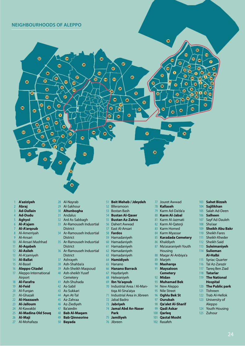
A’aziziyehAbrajAd-DallainAd-DuduAghyolAl-A’ajamAl-A’arqoubAl-AmerriyahAl-AnsariAl-Ansari MashhadAl-AqabehAl-AsilehAl-A’zamiyehAl-BallatAl-BaselAleppo CitadelAleppo International AirportAl-FarafraAl-FeidAl-FurqanAl-GhazaliAl-HazzazehAl-JalloumAl-KawakbiAl-Madina Old SouqAl-MajiAl-Mohafaza
123456789
1011121314151617
18192021222324252627
NEIGHBOURHOODS OF ALEPPO
Al-NayrabAl-SakhourAltunboghaAndalusArd As-SabbaghAr-Ramouseh Indusrtial DistrictAr-Ramouseh Indusrtial DistrictAr-Ramouseh Indusrtial DistrictAr-Ramouseh Indusrtial DistrictAshrayehAsh-Shahba’aAsh-Sheikh MaqsoudAsh-sheikh Yusef CemeteryAsh-ShuhadaAs-SabilAs-SukkariAyn At-TalAz-ZahraaAz-ZiediyehBa’aiedinBab Al-MaqamBab QinnesrineBayada
282930313233
34
35
36
37383940
41424344454647484950
Beit Meheb / JdeydehBlleramoonBostan BashBustan Al-QaserBustan Az-ZahraDahert AwwadEast Al-AnsariFardosHamadaniyehHamadaniyehHamadaniyehHamadaniyehHamadaniyehHamidiyehHananoHanano BarrackHaydariyehHelwaniyehIbn Ya’aqoubIndustrial Area / Al-Man-tiqa Al-Sina’aiyaIndustrial Area in JibreenJabal BadroJabriyehJamal Abd An-Naser ParkJamiliyehJibreen
5152535455565758596061626364656667686970
71727374
7576
Jouret AwwadKallasehKarm Ad-Da’da’aKarm Al-JabalKarm Al-JazmatiKarm Al-QaterjiKarm HomedKarm MyassarKarzdada CemeteryKhaldiyehMa’asaraniyeh Youth HousingMaqar Al-Anbiya’aMarjehMasharqaMaysaloon CemeteryMidanMuhamad BekNew AleppoNile StreetOghlu Bek StOurubahQa’alet Al-SharifQadi AskarQarleqQastal MoshtRasafeh
7778798081828384858687
88899091
9293949596979899
100101102
Sahet BizzehSajilikhanSalah Ad-DeenSalheenSayf Ad-DaulehSha’aarSheikh Abu BakrSheikh FaresSheikh KhederSheikh SaidSuleimaniyehSulieman Al-HalbiSyriac QuarterTal Az-ZarazirTareq Ben ZiadTatarlarThe National HospitalThe Public parkTishreenTrab Al-HellokUniversity of AleppoYouth HousingZuhour
103104105106107108109110111112113114
115116117118119
120121122123
124125
102
108
115
117
121
121
121
122
123
125
124
116
110 111
105 106
107
112
65
70
67
68
9
8
1032
3334
35
36
27
37
39
41
4194
42
43
44
45
46
79
52
53
56
81
87
88
89
82
86
95
83 84
77
57
5960
61
62
63
47
38
28
24
17
71
76
2021
31
15
72
29
13
100
101
103
104
109
113 114
118
119
120
120
106
1
2
4
5
64
66
69
7
6
11
22
23
40
80
48
4978
90
91
92
93
97
98
99
93
50
51
54
55
85
58
25
26
12
14
19
16
3096
18
73
74
75 3
29
24
CITY PROFILE OF ALEPPO | MAY 2014
Draft for
revision and endorsment

Draft for
revision and endorsment
Draft for
revision and endorsment

CONTACT INFORMATION:
UN-Habitat Damascus, Syria:E-mail: [email protected]: @unhabitatsyria
C I T Y P R O F I L E A L E P P O May 2014
City profiles will be updated every three months and be available online at: www.unhabitat.org
Disclaimers
The designations employed and the presentation of material on this map do not imply the expression of any opinion or endorsement whatsoever on the part of the Secretariat of the United Nations concerning the legal status of any country, territory, city or area or of its authorities, or concerning the delimitation of its frontiers or boundaries.
UN-Habitat does not bear responsibility for data collected by other partner organizations or authorities and cited in this report.
UN-Habitat Regional Office for Arab States, Cairo:E-mail: [email protected]. : +20237618812