alice k. strite property land management plan · an 83.3 acre site referred to as the alice k....
TRANSCRIPT

ALICE K. STRITE PROPERTY
LAND MANAGEMENT PLAN
Prepared by
Orange County Environmental Protection Division Green PLACE Program

TABLE OF CONTENTS
Page Introduction ……..…………………………………………………………………………....1 Site Description and Location Land Management Goals …………………………………………………………..................2 Area Overview ………………………………………………………………………………..3 Regional Significance Acquisition History Cooperative Agreements Leases, Easements and Concessions Cultural / Historical Resources Existing Improvements / Alterations Future Land Use and Zoning Natural Resources Overview ……………………………………….………………………...18 Climate Change Topography and Surface Hydrology Soils Natural Communities Invasive Exotic and Nuisance Species Listed Species Resource Management ………………………….……………………………………………32 Forest Management
Fire Management Cultural / Historical Resources
Public Access and Use ………..………………………………………………………………34 Access Recreation Environmental Education Security Implementation Timeline……………………………………………………………………...37 References …………………………………………………...……………………………......40 Appendices ……………………………………………………………………………………. A. Resolution approving Property Uses for Green PLACE properties B. Deed for County Land within the Preserve C. Master Species List for Alice K. Strite Parcel

LIST OF FIGURES
Number Page 1 General Location …………………………………………………………….4 2 Preserve Boundary …………………………………………………………..5 3 Regional Significance …………………..…………………………………...6 4-14 Historical Aerials……………………………………………………………7-17 15 Topography ………… ………………………………………………………20 16 Hydrology …………………………………………………………….……. 21 17 Quadrangle 1…………………………………………………………………22 18 Quadrangle 2 ………………….……………………………………………..23 19 Soils ……………………. ….………………………………………………..25 20 Natural Communities ………………………………………………………..28
LIST OF TABLES Number Page 1 Natural Communities …………..……………………………………….… 26 2 Invasive Exotic/Nuisance Plant Species List..………………………….…..29

INTRODUCTION
In his 2002 State of the County Address, Mayor Richard T. Crotty announced plans for the creation of the Green Park Land Acquisition for Conservation and Environmental Protection (PLACE) program. In 2003, Mayor Crotty and the Board of County Commissioners approved the funding for the Green PLACE Program. The initial funding for the program was a $20 million Public Service Tax Bond. Subsequent funding of $125 million was approved by the Mayor and the Board of County Commissioners in July of 2006. The Green PLACE program mission statement is as follows: “To preserve and manage environmentally sensitive lands, protect water resource lands and to provide a quality passive recreational outdoors experience for existing and future generations.” With assistance from the Green PLACE Ad Hoc Committee and its successor, the Green PLACE Advisory Board, a strategy was established for the acquisition of environmental sensitive lands which focused on the creation and expansion of ecological corridors. In addition, the Green PLACE Ad Hoc Committee assisted with the development of property uses that are allowed and prohibited for all Green PLACE properties (Appendix A). Orange County Green PLACE has adopted an internal Standard Operating Procedure (SOP) that states that a management plan must be written and implemented for all Green PLACE properties. The management plans must address land management issues, such as fire management, hydrologic restoration, threatened and endangered species, and invasive/exotic plant and animal species control. Secondly, the management plan needs to address the issues of public access and recreational uses. Site Description and Location An 83.3 acre site referred to as the Alice K. Strite property is located off of Mount Plymouth Sorrento Road in Orlando, Orange County, Florida, in Township 20S, Range 28E, Section 7 (Figure 1). The parcel is located west of the Neighborhood Lakes parcel and Rock Springs Reserve State Park and south of Orange County’s Fazio parcel. The Alice K. Strite parcel can be accessed off of Mount Plymouth Sorrento Road and Haas Road. The Alice K. Strite parcel is composed of five different natural communities, consisting mainly of pine plantation and sandhill in addition to xeric hammock and improved pasture. Main canopy species on the property include slash pine (Pinus elliottii), longleaf pine (Pinus palustris), and laurel oak (Quercus laurifolia). Understory species include saw palmetto (Seronoa repens), gallberry (Ilex glabra), fetterbush (Lyonia lucida), and shiny blueberry (Vaccinium myrsinites). Other species commonly found on the property include several species of St. John’s wort (Hypericum spp.), redroot (Lachnanthes caroliniana), and wax myrtle (Myrica cerifera), as well as several listed plant species.
1

LAND MANAGEMENT GOALS
The following goals provide the general framework for management of the Alice K. Strite property:
Maintain and restore, where appropriate, the natural hydrological regime Maintain and restore native natural communities (including control of exotic species), Enhance species diversity, Maintain and protect listed species, Protect archeological and cultural resources, and Provide opportunities for public recreation where compatible with the goals listed
above. This management plan provides strategies and actions to be employed in furtherance of these broad, guiding statements.
2

AREA OVERVIEW
Regional Significance The Alice K. Strite parcel is part of a large ecological corridor which consists of publicly owned lands in the northwestern portion of the County (Figure 3). These lands include: Wekiwa Springs State Park, Rock Springs Reserve State Park, Pine Plantation and Neighborhood Lakes. In addition, the property is within a mile of the Fazio Property which is owned by Orange County. Acquisition History The property was acquired in December of 2005 from the Strite-Holder family by Orange County through its Green PLACE program. In December 2005, approximately 83 acres were conveyed by Warranty Deed to the County for the purposes of resource management and passive outdoor recreational opportunities (Appendix B). Accordingly, the County is the owner and perpetual steward of the property (Appendix C). Cooperative Agreements The County has not entered into any Cooperative Agreements on this property. Leases, Easements and Concessions The County has not entered into any Leases, Easements, or Concessions at this time. Cultural / Historical Resources There are no known or previously recorded cultural or historical resources located on the property. At a future date, Orange County will have a cultural and historical review of the site performed by an archeological research firm. Existing Improvements / Alterations Most of the site is in a natural condition with some alteration from historical uses such as conversion to orange grove and pasture and timber resource management activities such as planting pines and timber harvesting. There are also several debris piles at the entrance off of Haas Road from land clearing activities. No other improvements/alterations have been initiated or observed at this time. Future Land Use and Zoning The Future Land Use category of A-1 is predominant over the entire property. The County plans to amend the Future Land Use Classification to Conservation Lands.
3

4

5

6

7

8

9

10

11

12

13

14

15

16

17
NATURAL RESOURCES OVERVIEW Climate Change Climate change is a growing concern regarding its possible adverse impacts to natural environments. While scientists remain uncertain about how the effects of climate change will manifest, their research suggests that natural environments are vulnerable. Climate change can affect natural areas and the ecology of managed areas in many ways. Some of the possible changes include:
A rise in temperature that can change the movement of native and invasive plants, and wildlife,
An increase in the strength and occurrence of natural disasters such as hurricanes, Increased development adjacent to managed natural areas due to coastal retreat from a
rise in sea level, An increase in rainfall that may cause ecological changes to natural community types.
Many of the issues that are being addressed for the adverse impacts from development parallel many of the same issues for climate change. It is EPD’s intention to be aware of climate change and its possible adverse impacts to the natural areas and respond to the issues proactively. Goal: Maintain and restore native natural communities. Strategy: Address climate change issues for the Alice K. Strite property. Actions:
Investigate how climate change issues may affect the property. Address, if necessary, any adverse impacts expected from climate change. Investigate grants for climate change preparedness. Continue to monitor the vegetation and wildlife on the property and address any
environmental changes to the ecology of the site. Topography and Surface Hydrology Topographic relief across the property is significant with the highest elevations found on the eastern portion of the property from 120 to 140 feet above sea level. The lower elevations are on the western portion of the property from 85 to 115 feet above sea level (Figure 15). The property strictly consists of Candler fine upland sloping soils with no natural wetland areas. Generally with Candler fine soils a seasonal high water table is at a depth of more than 80 inches with low water capacity. These soils are excessively drained with rapid permeability in the surface and subsurface layers. It is written in the Green PLACE mission statement to, “protect water resource lands”. The aquifer recharge potential on the Strite property is rated very high and considered a valuable water resource land (Figure 16). Hydrologic features on the property include a 1.5 acre stormwater pond located on the northeast corner of the property.
18

Goal: Maintain and restore, where appropriate, the natural topographic regime. Strategy: Maintain and restore the natural topographic regime. Actions:
Maintain and restore the natural topographic regime.
19

20

21

22

23

Soils The dominant soil types within the Alice K. Strite property as defined by the Natural Resource Conservation Service (formerly the Soil Conservation Service) are as follows: Candler Fine sand, 0 to 5 percent slope Candler Fine sand, 5 to 12 percent slope Candler fine sand, 0 to 5 percent slope: This soil is nearly level to gently sloping and excessively drained. The seasonal high water table is at a depth of more than 80 inches. Natural vegetation that typically occurs on this soil type is scattered slash pine, longleaf pine, bluejack oak (Quercus incana), Chapman’s oak (Quercus chapmanii), scrub live oak (Quercus inopina) and turkey oak (Quercus laevis). Typical understory species include saw palmetto, lopsided indiangrass (Sorghastrum secundum), chalky bluestem (Andropogon virginicus), and hairy panicum (Panicum anceps). Candler fine sand, 5 to 12 percent slope: This soil is sloping and strongly sloping and is excessively drained. The seasonal high water table is at depth of more then 80 inches. Natural vegetation that typically occurs on this soil type is scattered slash pine, sand pine, longleaf pine, bluejack oak, Chapman oak, scrub live oak and turkey oak. Typical understory species include lopsided indiangrass, chalky bluestem, hairy panicum and pineland threeawn (Aristida stricta).
24

25
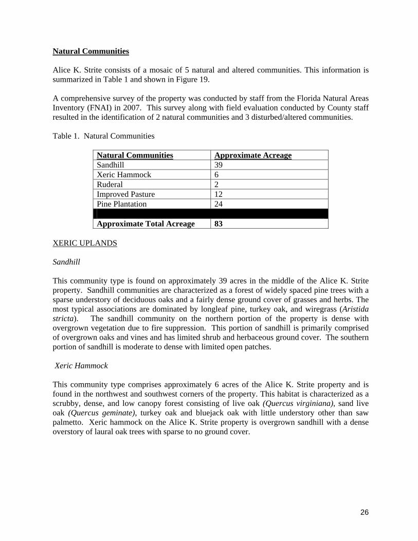
Natural Communities Alice K. Strite consists of a mosaic of 5 natural and altered communities. This information is summarized in Table 1 and shown in Figure 19. A comprehensive survey of the property was conducted by staff from the Florida Natural Areas Inventory (FNAI) in 2007. This survey along with field evaluation conducted by County staff resulted in the identification of 2 natural communities and 3 disturbed/altered communities. Table 1. Natural Communities
Natural Communities Approximate Acreage Sandhill 39 Xeric Hammock 6 Ruderal 2 Improved Pasture 12 Pine Plantation 24 Approximate Total Acreage 83
XERIC UPLANDS Sandhill This community type is found on approximately 39 acres in the middle of the Alice K. Strite property. Sandhill communities are characterized as a forest of widely spaced pine trees with a sparse understory of deciduous oaks and a fairly dense ground cover of grasses and herbs. The most typical associations are dominated by longleaf pine, turkey oak, and wiregrass (Aristida stricta). The sandhill community on the northern portion of the property is dense with overgrown vegetation due to fire suppression. This portion of sandhill is primarily comprised of overgrown oaks and vines and has limited shrub and herbaceous ground cover. The southern portion of sandhill is moderate to dense with limited open patches. Xeric Hammock This community type comprises approximately 6 acres of the Alice K. Strite property and is found in the northwest and southwest corners of the property. This habitat is characterized as a scrubby, dense, and low canopy forest consisting of live oak (Quercus virginiana), sand live oak (Quercus geminate), turkey oak and bluejack oak with little understory other than saw palmetto. Xeric hammock on the Alice K. Strite property is overgrown sandhill with a dense overstory of laural oak trees with sparse to no ground cover.
26

ALTERED AREAS Ruderal: According to Merriam-Webster Dictionary, this habitat is defined as natural vegetation that is growing within an area that has been disturbed by manmade activities. This community type comprises approximately 2 acres of the Alice K. Strite property. Improved Pasture In Florida, improved pastures are areas where the native vegetation has been replaced with non-native species such as bahia grass (Paspalum notatum) and St. Augustine grass (Stenotaphrum secundatum). Often, improved pastures have been drained and fertilized regularly for cattle grazing. In the case of the Alice K. Strite property, these pasture areas contain a dominant cover of pasture grasses. This community type comprises approximately 12 acres of the property. These areas are currently maintained by mowing activities until restoration efforts are initiated. Pine Plantation This community type comprises 24 acres of Alice K. Strite property. This community type is characterized by the densely planted rows of even age pine trees for the sustainable production of lumber and pulpwood products.
27

28

Invasive Exotic and Nuisance Species Plants Exotic, non-indigenous, non-native, and alien species are all terms used to describe plants that are of foreign origin. Some exotic species can be invasive and harm or displace native species and alter native ecosystem function. Well-known and wide spread non-indigenous plant species found on the Alice K. Strite property include camphor tree (Cinnamomum camphora) and Chinaberry (Melia azedarach). A native to Asia, camphor tree is able to rapidly displace native trees and infest forests and other natural areas. It displaces native plants due to its fast growth and ability to produce large amounts of seed. Chinaberry is a native to Asia and is typically found on the boundary of native areas, if the species is not controlled or eradicated it may take over natural areas. The types of invasive exotic species found on the property are Category I and II species according to the Florida Exotic Pest Plant Council (FLEPPC). In addition to invasive species like camphor tree and Chinaberry, there are moderate to dense amounts of encroaching invasive exotic plant species throughout the property. A list of the invasive exotic and nuisance species observed on the property is provided in Table 2. A detailed inventory of invasive exotic and nuisance plants has been conducted; however, other exotic species are likely to exist on-site. Staff has prepared an inventory database for invasive plant species found within the Alice K. Strite property and are developing strategies to remove the species or to control their coverage. Staff is currently developing a comprehensive treatment and monitoring program to ensure the long-term removal of these species. Table 2: Invasive Exotic/Nuisance Plant Species List – Alice K. Strite Property– November 2008
Scientific Name Common Name Category
Cinnamomum camphora Camphor tree I Lantana camara Lantana I Melinis repens Rose natal grass I Nephrolepis cordifolia Sword fern I Triadica sebifera Chinese tallow I Melia azedarach Chinaberry II Urochloa maxima Guinea grass II
FLEPPC compiles invasive species lists that are revised every two years. Professional botanists and others perform studies to determine invasive exotic plants that should be placed on the lists. Invasive exotic plants are termed as Category I, Category II, or Category E which are explained as the following: Category I - Invasive exotics that are altering native plant communities by displacing native species, changing community structures or ecological functions, or hybridizing with native species. This definition does not rely on the economic severity or geographic range of the problem, but on the documented ecological damage caused.
29

Category II - Invasive exotics that have increased in abundance or frequency but have not yet altered Florida plant communities to the extent shown by Category I species. These species may become ranked Category I, if ecological damage is demonstrated. Category E- Exotics that are not or not yet classified in any other category. Animals Exotic and non-indigenous animal species have the potential to adversely affect ecosystem function and to significantly alter population levels of native animals through predation or displacement. A formal inventory of the property for exotic animal species has not been conducted. An investigation into the levels and impacts of these species needs to be conducted prior to the establishment of a control strategy. Goal: Maintain and restore native natural communities including control of exotic species. Strategy: Eradicate or control to a manageable level exotic invasive and nuisance species. Actions:
Develop a methodology and work plan to accomplish the identification of exotic plant and animal species.
GPS the location of identified invasive species within and/or adjacent to the property. Control and eradication efforts of newly occurring or re-occurring populations of these
undesirable species may include, but are not limited to, mechanical and chemical procedures with priority being given to Category I pest plants listed by the FLEPPC.
Routinely monitor the management area for new or re-occurrence of invasive exotic and nuisance species.
Educate neighboring properties and the public regarding the planting of undesirable plants or non-native plants as listed by FLEPPC.
General Wildlife
No comprehensive faunal surveys have been initiated for the property. The limited size of natural communities found within the site and the poor condition of the natural communities does not provide suitable habitat for use by a broad range of animal species. For a list of currently observed species refer to Appendix D. Some examples of wildlife which may be found on the property include gopher tortoise (Gopherus polyphemus) and swallow tailed kite (Elanoides forficatus). Listed Species (Fauna)
The United States Fish and Wildlife Services (USFWS) and the State of Florida under the auspices of the Florida Fish and Wildlife Conservation Commission (FWC) compile lists of protected wildlife species considered to be under possible threat of extinction. These listed species are categorized as Endangered, Threatened or Species of Special Concern. Gopher tortoise (Gopherus polyphemus) has been observed on the property. With the presence of gopher tortoise on the site, other listed commensal species may also be present such as, but not
30

limited to, the indigo snake (Drymarchon corais), gopher frog (Rana capito) and Florida mouse (Podomys floridanus). Gopher Tortoise Gopher tortoises have been observed on the site. The FWC changed the status of the gopher tortoise from Species of Special Concern to Threatened in November 2007. No formal survey has been conducted on the Strite property to determine if the population is stable and in good health. Managing the sandhill habitat and reintroducing prescribed fire will enhance the habitat by opening up the understory, thereby increasing the amount of habitat open to foraging and colonization. Listed Species (Flora) The presence of sandhill community on the property provides potential habitat for many rare and listed species. Pigmy fringetree (Chionanthus pygmaeus), is state and federally listed as endangered and is located within the southern portion of the sandhill habitat on the property. The Pygmy fringe tree is an endemic shrub native to the coarse, wind-deposited sands of central Florida. This species depends on fire to maintain open, sandy patches to be able to thrive. Loss of habitat and lack of fire has caused the endangered status of this species. Further listed species present on the property will be investigated during future monitoring events. Goal: Maintain and protect listed species. Strategy: Identify and protect on-site populations of endemic, rare, threatened and endangered species through the utilization of existing habitat management and species recovery plans. Actions:
Develop a methodology and work plan to accomplish the survey for and identification of designated plant and animal species.
Plot the location of identified designated species within and/or adjacent to the property for use in the implementation, or re-distribution, of amenities or site improvements.
Periodically update these baseline survey data to determine possible changes in designated species distribution or density.
Implement habitat enhancement and restoration activities for listed species (i.e., removal of exotic/nuisance species, restoration of ecosystem function, prescribed fire).
Establish periodic monitoring of habitat suitability (where indices are available for a given species), species population levels, diversity levels, and exotic/nuisance species, as a means of evaluating the success of management strategies.
31

RESOURCE MANAGMENT Restoration This property will be managed in such a manner as to promote conditions favoring the natural and historical aspects of the property. As evidenced by historical aerial photographs, the type of vegetative cover that characterized the property prior to the 1940’s is not comparable to present day. Notable differences exist in the density and extent in the coverage of the communities. These differences are attributed to changes in the fire regime, and cultural and management activities including agricultural pursuits such as the conversion of natural areas to pine tree plantation, orange grove, and pasture. Most of the property will require habitat enhancement through forest and fire management and vegetative mechanical treatments. In addition, restoration will be needed in pasture and other disturbed areas of the property by removing invasive exotic species and seeding with native seed appropriate for the community type. Soil maps, historical aerials, and site visits indicate the natural areas most affected by change. From this aforementioned information, it appears that most of the property will be enhanced or restored to a sandhill community type. There is also a need for the replanting of canopy species, primarily longleaf pine, within the pine plantation and sandhill portions of the property. These replanting areas will be addressed in more detail in future operational plans. Goal: Maintain and restore native natural communities. Strategy: Develop and implement a detailed restoration plan for the property. Actions:
Develop and implement a detailed restoration plan for the property. Develop projected costs for restoration evaluation and implementation. Explore grant opportunities for additional funding of projects.
Forest and Fire Management Forest and fire management activities are critically important and integrally linked. It is crucial to understand that the planning and application of forest and fire management activities must be coordinated to achieve restoration and management goals. Both fire management activities and forest management activities can be useful tools in promoting natural community diversity and reducing potentially hazardous fuel loads. Forest Management Approximately 15 acres of slash pine plantation exists on the east portion of the property and approximately 8 acres exists on the southwest portion of the property. These areas will be harvested with the main objective of actively managing the timber to enhance the ecological
32

and wildlife value of the property through wildlife and natural resources improvement, and to prepare natural areas for fire management. There were several factors over time that have caused for a reduction of longleaf pine within the sandhill and pine plantation areas. These include clearing projects involved with agricultural pursuits for citrus groves and pine plantation and historic harvesting events. Historically, it appears that the pine plantation portion of the property was sandhill dominated with scattered longleaf pine at varying basal areas. There is no other timber on the property that would require harvesting for habitat enhancement. An objective-based approach to habitat management will be used for the property. As such, a set of Desired Future Conditions (DFCs) will be developed for the various habitats. The DFCs, which will be established after extensive analysis of the existing conditions, are intended to serve as guides for achieving preferred habitat conditions for plant and animal species. Initial sampling will provide staff with baseline data indicating the vegetative condition. Regular vegetation monitoring, in accordance with standard methods, will be used to assess the level of success in obtaining the desired conditions. Monitoring will involve sampling for variables associated with particular DFCs within a management unit. Results obtained from monitoring will be used to ascertain if the DFCs have been met. This habitat-based management approach does not necessarily mandate recurring harvesting of marketable timber and replanting across the property. Limited silvicultural practices, which may include periodic harvesting and replanting, within the pine plantation, will be undertaken in the context of furthering the overall health and vitality of a habitat as expressed by the DFCs. An analysis of anticipated costs and potential revenues associated with harvesting and planting activities will be prepared when further implementing of these activities occur in accordance with the DFCs. The County will conduct a salvage harvest as needed to remove trees in the case of insect infestations, disease, damage from severe weather, or other occurrences that could jeopardize the health of the natural communities. If any clearcuts occur due to the above instances, the County will assess each stand and begin to implement appropriate restoration and reforestation techniques based on each stand. This may include burning and any necessary groundcover restoration, followed by planting with appropriate overstory species, typically slash or longleaf pine. When needed, groundcover planting or direct seeding will be used in conjunction with natural regeneration. Fire Management The overall forest management program for the property will include the use of prescribed fire. Prescribed fire is the preferred management technique to be employed for habitat maintenance and restoration on the property. Utilizing prescribed fire within the Alice K. Strite property will benefit ecosystems that have evolved under the influences of this natural process in Florida. The Orange County Environmental Protection Division is responsible for protecting the rich biological diversity of its natural lands by actively managing it. It is widely recognized that prescribed fire, applied in established frequencies specific to each ecosystem, is an important land management tool to
33

promote biodiversity through the reintroduction of fire to dependant ecosystems. Prescribed fire also has the added benefit of lowering and maintaining fuel loads, thus mitigating the behavior and effects of wildfires that start in or outside of the property. Natural communities within the property will be evaluated to determine any constraints upon the use of prescribed burning posed by natural site conditions and adjacent land uses. When necessary, other methods, including mowing and herbicide will be utilized in place of prescribed burning. These alternative strategies will be emphasized in areas where fire cannot be applied at all or when the required prescribed burning weather conditions are defined within such a narrow parameter that they are infrequently met. In the short term, prescribed fire may be used in lieu of mowing activities and/or in conjunction with restoration activities. Goal: Maintain and restore native natural communities. Strategy: Develop a timber management program on the Alice K. Strite property. Actions:
Develop a forest management plan for the property. Conduct thinning operations in pine stands when appropriate. Monitor forested areas for drought, disease, or insect infestations and utilize chemical
treatments or timber removal as needed. Evaluate any clearcut areas and implement appropriate restoration techniques.
Strategy: Develop a prescribed fire management program on the Strite property. Actions:
Create a fire management plan that includes management unit/subunit maps and corresponding fuel load information.
Implement a wildfire policy. Develop cooperation with other agencies. Implement a fire line installation standard operating procedure (SOP). Implement a fire line maintenance schedule. Develop and implement a standard burn prescription.
PUBLIC ACCESS AND USE
Access Adequate access is a necessity for land management activities. Law enforcement patrol, prescribed burning activities and fire suppression are but a few of the activities that benefit from improved road access. Currently, an access gate is located off of Haas Road which is located off of Plymouth/Sorrento Road (former Orange County 437). Future access gates off of Plymouth/Sorrento Road may also be needed as part of the fire and forest management plan. Parts of the road system may need improvements to facilitate the movement of vehicles, as well as heavy equipment for restoration or maintenance purposes. Widening and leveling current
34

roads, or capping soft roads and/or areas for parking with shell, rock or clay are some of the possibilities for needed upgrades. Currently, no fence exits along the interior out-parcel allowing the possibility for uncontrolled public access. A fence is planned to be installed in 2009 along the out-parcel to discourage trespassing and allow for designated entrances. In addition, during the fence installation, a fire line/road will be installed along the fence line. Also, fire lines/roads are planned along the boundary of the property. Other fire lines/roads and trails have not yet been planned. Also, parking areas for future public access have not yet been determined. Goal: Provide access to all or most areas of the property for management and/or recreational activities. Strategy: Develop a road and trail plan that addresses access issues and includes maintenance plans with associated costs. Actions:
Address access issues for the property. Develop a road/trail maintenance plan with associated costs. Address access issues during the development of restoration plans.
Recreation It is desired that recreational opportunities be established for Green PLACE properties. Public uses for all Green PLACE properties are broken down into 3 categories: Primary, Secondary and Prohibited. These categories were developed in conjunction with the Green PLACE Ad Hoc Advisory Committee and subsequently approved by the Orange County Board of County Commissioners. Due to the nature of the habitats and their quality, only primary uses are planned at this stage to be allowed to occur on the property. In the future, EPD will evaluate the site to determine if any of the secondary uses would also be compatible on the property. The approved Property Uses are attached in Appendix A. Goal: Provide recreational opportunities for the public. Strategy: Develop a trail system that allows access to the various habitats. Actions
Delineate proposed trail system utilizing GIS and the most current aerials. Ground truth proposed trail layout. Implement the construction and maintenance of trails and other associated amenities. Implement a regional campaign/marketing program to advertise Orange County
recreational sites.
35

Environmental Education Environmental education is essential to a successful land acquisition and management program. Educating the public on the benefits of a land acquisition program will enhance your public support base for future bond issues. In addition, educating the public on the types of land management activities that need to be performed, such as prescribed fire and timber harvesting, will lessen negative feedback from the public when these activities are conducted. Lastly, a good educational program will increase the publics’ knowledge of the diverse plant and animal species that occur in Florida and give them a better understanding of the uniqueness and beauty of Florida’s various ecosystems. Goal: Develop educational kiosks and pamphlets for the Alice K. Strite property. Strategy: Develop a Docent program that can be utilized for all properties. Develop a land management presentation that can be customized to the specific needs of each property. Actions:
Develop and conduct guided hikes. Present information on the specific land management activities that are proposed for the
property to the neighboring community. Security Adequate security is essential for all Green PLACE properties. Security in the form of fences and authorized access points will reduce the incidence of trespassing on Green PLACE properties and minimize the damage to the property from unauthorized activities. In addition, securing the boundaries will reduce the County’s liability. County boundary signs will also be utilized on different areas of the boundary fence to discourage trespassing. Goal: Secure the boundaries of the Alice K. Strite parcel and identify authorized public access points. Strategy: Develop a general security Standard Operation Procedure for all Green PLACE properties. Actions:
Fence all appropriate property boundaries. Coordinate with the Orange County Sheriff’s Office to patrol the property. Post signage that identifies authorized access points for the property and authorized uses
that are allowed on the property. Develop a plan for patrolling the property to identify and correct security issues on a
timely basis.
36

IMPLEMENTATION TIMELINE
ACTION TIMELINE Strategy: Address climate change issues for the Alice K. Strite property.
Investigate how climate change issues may affect the property On-going
Address, if necessary, any adverse impacts expected from climate change On-going
Investigate grants for climate change preparedness On-going Continue to monitor the vegetation and wildlife on the property and address any environmental changes to the ecology of the site On-going Strategy: Investigate potential restoration for the cattle pond located on the property. Investigate the restoration of the cattle pond to its historic sandhill community. Short-term Strategy: Eradicate or control to a manageable level exotic invasive and nuisance species. Develop a methodology and work plan to accomplish the identification of exotic plant and animal species Short-term GPS the location of identified exotic species within and/or adjacent to the property On-going Control and eradication efforts of newly occurring or re-occurring populations of these undesirable species may include, but are not limited to, mechanical and chemical procedures with priority being given to Category I pest plants listed by the FLEPPC On-going Routinely monitor the management area for new or re-occurrence of invasive exotic and nuisance species On-going Educate neighboring properties and the public regarding the planting of undesirable plants or non-native plants as listed by the FLEPPC On-going Strategy: Identify and protect on-site populations of endemic, rare, threatened and endangered species through the utilization of existing habitat management and species recovery plans. Develop a methodology and work plan to accomplish the survey for and identification of designated plant and animal species On-going Plot the location of identified designated species within and/or adjacent to the property for use in the implementation, or re-distribution, of amenities or site improvements Short-term Periodically update these baseline survey data to determine possible changes in designated species distribution or density Short-term Implement habitat restoration activities for listed species (i.e., removal of exotic/nuisance species, restoration of ecosystem function, prescribed fire) On-going
37

Establish periodic monitoring of habitat suitability (where indices are available for a given species), species population levels, diversity levels, and exotic/nuisance species, as a means of evaluating the success of management strategies On-going Strategy: Develop and implement a detailed restoration plan for the property. Develop and implement a detailed restoration plan for the property Short-term Develop projected costs for restoration evaluation and implementation Short-term Explore grant opportunities for additional funding of projects Short-term Strategy: Develop a forest management program on the Alice K. Strite property Develop a forest management plan for the property On-going Conduct thinning operations in pine stands when appropriate Short-term Monitor forested areas for drought, disease, or insect infestations and utilize chemical treatments or timber removal as necessary On-going Evaluate any clearcut areas and implement appropriate restoration techniques On-going Strategy: Develop a prescribed fire management program for the Alice K. Strite Property. Create a fire management plan that includes management unit/subunit maps and corresponding fuel load information Immediate Implement a wildfire policy Immediate Develop coordination with other agencies On-going Implement a fire line installation standard operating procedure (SOP) Short-term Implement a fireline installation maintenance schedule Short-term Develop and implement a standard burn prescription Short-term
Strategy: Develop a road and trail plan that addresses access issues and includes maintenance plans with associated costs
Address access issues for the property Immediate Develop a road and trail maintenance plan with associated costs Immediate Address access issues during the development of restoration plans Long-term Strategy: Develop a trail system that allows access to the various habitats Delineate proposed trail system utilizing GIS and the most current aerials Short-term Ground truth proposed trail layout Short-term Implement the construction and maintenance of trails and other associated amenities On -going Implement a regional campaign/marketing program to advertise Orange County recreational sites. Long-term
38

Strategy: Develop a Docent program that can be utilized for all properties. Develop a land management presentation that can be customized to the specific needs of each property. Develop and conduct guided hikes Long -term Present information on the specific land management activities that are proposed for the property to the neighboring community Short-term Strategy: Develop a general security Standard Operating Procedure for all Green PLACE properties. Fence all appropriate property boundaries Immediate Coordinate with Orange County Sheriff’s Office to patrol the property On-going Post signage that identifies authorized access points for the property and authorized uses that are allowed on the property Short-term Develop a Standard Operating Procedure for patrolling the property to identify and correct security issues on a timely basis Short-term
39

40
REFERENCES The Guide to the Natural Communities of Florida. Florida Natural Areas Inventory and Florida Department of Natural Resources. February, 1990. Hal Scott Regional Preserve and Park Land Management Plan. St. Johns River Water Management District. October, 2007. Florida Forever Five Year Plan, 2007. Florida Department of Environmental Protection, Division of State Lands. List of Invasive Species, 2007. Florida Exotic Pest Plant Council. Longleaf Pine Preserve Land Management Plan. County of Volusia, Division of Land Acquisition and Management. October, 2006. North Buck Lake Scrub Sanctuary Draft Management Plan. Brevard County, Environmentally Endangered Lands Program, Parks and Recreation Department. 2007. Soil Survey of Orange County, Florida. U. S. Department of Agriculture, Soil Conservation Service in cooperation with University of Florida, Institute of Food and Agricultural Sciences.

Appendix A
Resolution Approving Property Uses for Green PLACE properties
1

2

1

2
Appendix B
Deed for County Land within the Preserve

1

2

3

4

5

6

Appendix C
Master Species List for Alice K. Strite Parcel
7

Type Family Scientific Name Common Name
Flora Anacardiaceae
Rhus copallina Winged Sumac, Shining Sumac
Aquafoliaceae Ilex opaca American Holly
Arecaceae Serenoa repens Saw Palmetto
Asteraceae Ambrosia artemisiifolia Common Ragweed Bidens pilosa Spanish Needles Coreopsis lanceolata Tickseed, Lance-Leaved Coreopsis Eupatorium capillifolium Dogfennel Heterotheca subaxillaris Camphorweed Hieracium megacephalon Hawkweed Pterocaulon pycnostachyum Blackroot Taraxacum officinale Common Dandelion
Bromeliaceae Tillisandia usneoides Spanish moss
Cactaceae Opuntia humifusa Pricklypear Cactus
Commelinaceae Callisia ornata Roseling
Convolvulaceae Ipomoea pes-caprae Railroad-Vine
Cupressaceae Juniperus virginica Red Cedar
Dioscoreaceae Dioscorea bulbifera Air Potato
Ebenaceae Diospyros virginiana Common Persimmon
Fabaceae Dalea pinnata Summer Farewell
Galactia elliotii Pea Vine, Elliott's Milkpea, White Milkpea
Lupinus diffusus Skyblue Lupine
Fagaceae
Quercus laurifolia Diamond Leaf Oak, Laurel Oak Quercus myrtifolia Myrtle Oak
Lamiaceae Hyptis verticillata Bushmint
Lauraceae Cinnamomum camphora Camphor Tree
8

Meliaceae Melia azedarach Chinaberry Tree
Nephrolepideceae Nephrolepis exaltata Sword Fern
Oleaceae Chionanthus pygmaeus Pigmy Fringetree
Passifloraceae
Passiflora incarnate Passion Flower Vine, Maypop, Apricot-Vine
Phytolaccaceae Phytolacca americana Pokeweed
Pinaceae Pinus elliottii Slash Pine
Poaceae Cynodon dactylon Bermuda Grass Melinis repens Natal grass Paspalum notatum Bahiagrass Saccharum coarctatum Sugarcane Plumegrass
Polemoniaceae Phlox nivalis Trailing Phlox
Rosaceae Prunus serotina Black Cherry Rubus cuneifolius Sand Blackberry
Rutaceae Citrus aurantium Sour Orange Tree
Verbenaceae Lantana camara Lantana, Shrub Verbena
Vitaceae Parthenocissus quinquefolia Virginia Creeper Vitis rotundifolia Muscadine Grapevine
Fauna Accipitridae Elanoides forficatus Swallow-tailed Kite
Nymphalidae Heliconius charitonius Zebra Longwing
Testudinidae Gopherus polyphemus Gopher Tortoise
Tetragnathidae Nephila clavipes Golden Silk Orbweaver
9

10