all-day field-trip to the wairarapa fault and 1855 rupture sites
TRANSCRIPT

1
1855 Wairarapa Earthquake Symposium: All-day Field-trip to the Wairarapa Fault and 1855 Rupture Sites
Trip Co-Leaders: Tim Little, School of Earth Sciences, Victoria University of Wellington John Begg, Institute of Geological and Nuclear Sciences, Lower Hutt Published by Greater Wellington Regional Council Greater Wellington Publication Number: GW/RINV-T-05/206 ISBN - 0-909016-88-7 September 2005

2
Frontispiece: Oblique aerial photo looking northward along the trace of the Wairarapa Fault. Featherston is in the middle foreground. Photograph is by Lloyd Homer (GNS).

3
Introduction The Wairarapa Fault east of Wellington, New Zealand ruptured on January 23, 1855, resulting in ground shaking, landslides, regional uplift, tsunamis, and >120 km of ground rupturing (Grapes, 1999; Downes and Grapes, 1999). Modern estimates of magnitude based on dislocation modeling of the observed distribution of vertical uplift, and on the felt extent of ground shaking (Fig. 1) suggest a moment magnitude (Mw) of 7.9 to 8.2 (Darby and Beanland, 1992; Dowrick, 1992), whereas revised measurements of surface offset and inferred rupture size suggest an Mw of ≥8.2 (Little and Rodgers, 2005; Rodgers and Little, in review). This makes the 1855 earthquake by far the largest seismic event in modern New Zealand history (Van Dissen and Berryman, 1996). The goal of this field trip is to provide participants with an overview of the tectonics, geomorphology, and earthquake geology of the active Wairarapa Fault, and for them to see the fault rupture and slip that took place during a recent (in this case, ~150 year old) earthquake. Recent work measuring offset landforms indicates that the amount of horizontal motion (strike-slip) that took place during the 1855 earthquake, while quite variable from place to place, has until recently probably been underestimated. One of the goals of this field-trip will be to visit sites in the southern Wairarapa Valley along the 1855 rupture where “smallest” strike-slip offsets of 15 -18.5 m, can be seen in the landscape and to discuss whether or not these displacements should be attributed to earthquake slip during 1855.
Fig. 1. Isoseismal map of 1855 earthquake (from Grapes and Downes, 1997) showing area of ground damage (stippled) and rupture along Wairarapa Fault. W = Wellington. Inset- cross-section along A-B showing inferred shape and extent of Wairarapa Fault rupture at depth during 1855 (after Darby and Beanland, 1992).

4
Wairarapa Fault: Tectonic Setting and Slip-Rate North Island, New Zealand lies on the eastern edge of the Australian Plate (Fig. 2). To the east, the Pacific Plate enters the northeast-trending Hikurangi Trough and is subducted beneath the east coast of the North Island along a plate interface (subduction zone) that is inclined 10-15° to the NW beneath the city of Wellington (e.g., Darby and Beavan, 2001). The Pacific Plate has a relative motion with respect to the Australian Plate of ~39 mm/yr along an azimuth of 261° (DeMets et al., 1990, 1994). This plate motion direction is oblique (i.e., not perpendicular) to the northeast-trending trench, so that the overall motion includes both a margin-parallel (strike-slip) and a margin-perpendicular (convergence) component. At the southern end of the North Island, several major dextral strike-slip faults cut the upper plate of this subduction zone. These are the Ohariu, Wellington, and Wairarapa faults (Langridge et al. 2005). Summed together, strike-slip on these faults can account for most of the margin-parallel component of the oblique plate motion. Slip on these faults typically also includes a small vertical component (most commonly up-to-the-NW). Because this component of slip causes differential uplift across the fault, it has a marked effect on the landscape. The rest of the convergent component of plate motion is mostly taken up by slip on offshore thrust faults that merge downwards into the subduction interface itself (e.g., Barnes & Mercier de Lepinay, 1997).
Fig. 2. Tectonics of southern North Island, New Zealand. Inset shows location of map and relative Pacific-Australia plate motions (from DeMets et al, 1992, 1994).

5
The Wairarapa Fault is a rapidly moving oblique-slip fault that bounds the eastern side of the Rimutaka Range, forming a topographic step between the range and the subdued alluvial plain of the Wairarapa Valley to the east (Fig. 3). Dipping steeply northwest, this dextral-reverse fault may be complex at the surface, consisting of an up to 250 m-wide zone of fault traces and/or deformational bulges that have been active in the late Quaternary (i.e., during the past c. 100 thousand years (ka)). One estimate of the late Quaternary slip rate of the Wairarapa Fault is based on 125±5 m of cumulative dextral-slip and 20±2 m vertical slip of abandoned river channels on the Waiohine terrace at Waiohine River in the central Wairarapa Valley (Lensen & Vella, 1971; Grapes and Wellman, 1988). Recent Optically Stimulated Luminescence (OSL) dating at Waiohine River (Fig. 2) have yielded OSL ages of 10.2±1.2 and 13.0±0.9 ka (mean ~11.6 ka) (Wang, 2001). These ages are similar to 5 other OSL ages for the same surface in the west-central Wairarapa Valley by Wang (2001) (range: 7.5 – 16.0 ka; mean ~11.8 ka); and 4 others in the eastern Wairarapa Valley by Formento-Trigilio et al. (2002) (range 5.1- 10.5 ka; mean, ~8. 5 ka). At Waiohine River, the dating results imply a dextral-slip rate of 11.5±0.5 mm/yr and a vertical slip rate at that site of 1.7±0.2 mm/yr (Wang, 2001).
Fig. 3. Shaded Digital Elevation Model of a southern part of the North Island showing route of this field-trip (black lines), fault traces (white lines, from GNS Active Fault Database), and other selected features (labeled). Field-trip stops are indicated by the numbered triangles (1-7). Paleoseimicity and 1855 Slip Along the Wairarapa Fault Four 14C ages from a trench at Tea Creek Road (Fig. 2), have been used to infer a mean recurrence of ~1500-1600 yrs for the last 5 surface rupturing events on the Wairarapa Fault (Van Dissen and Berryman, 1996), whereas the uplifted sequence of 4 Holocene beach ridges at Cape Turakirae suggest a mean earthquake recurrence of ~1900 yrs (Hull and McSaveney,

6
1996; Begg and McSaveney 2005; McSaveney et al. submitted). In detail, the paleoseismic chronology for the Tea Creek trench differs with that inferred from the uplifted beach ridges at Cape Turakirae (Hull and McSaveney, 1996); for example, the former suggests that the penultimate earthquake on the Wairarapa Fault took place at 1400-1530 cal yrs BP, whereas the latter suggests that it took place ~2250 cal yrs BP. Historic accounts indicate that the 1855 earthquake ruptured the Wairarapa Fault, causing intense shaking and widespread landsliding, especially in the Rimutaka Range and, perhaps most spectacularly, at Kopuaranga north of Masterton (Grapes and Downes, 1997). Fresh scarps attributed by Grapes (1999) to the 1855 rupture are preserved in the landscape as much as ~88 km northward from the coast at Mauriceville (Fig. 2). More recent work suggests that slip in 1855 may also have ruptured a northward continuation of the Wairarapa Fault, the Alfredton Fault. Scarps along that fault were rejuvenated sometime after 250 - 330 years BP, implying that the 1855 rupture may have extended to Alfredton, as much as 30 km beyond Mauriceville (Schermer et al., 2004). These data suggest that the onshore part of the 1855 rupture could have been as long as ~120 km. The onshore Wairarapa Fault is flanked to the west by an active anticline uplifting the Rimutaka Range. Near the southern end of the fault, this anticline lies parallel to the active Wharekauhau Thrust (Fig. 2). The thrust transfers strike-slip across a ~5-km wide left-stepover or bend in the fault into the offshore region. The crest of the Rimutaka Anticline meets the south coast ~4 km to the NE of Cape Turakirae. There, an uplifted series of Holocene beach ridges are preserved on the wave-cut shore platform. The youngest of these was locally uplifted as much as 6.4 m relative to sea level in 1855 (Hull and McSaveney, 1996). Farther to the NE, on the on-land part of the fault trace, up-to-the-NW vertical slip (relative to the eastern block) has been inferred to decrease northward from ~2.7 m near the Palliser Bay coast to as little as ~0.5 m near Mauriceville (Grapes and Downes, 1997; Grapes, 1999). South of the coast, the 1855 rupture is inferred to have extended offshore into Palliser Bay, the probable location of its epicenter (Darby and Beanland, 1992; Grapes and Downes, 1997). Seismic reflection data delineate a ~35-40 km-long offshore extension of the Wairarapa Fault, a structure which appears to terminate southwestward into Cook Strait (Barnes and Audru, 1999). These observations can be used to infer a maximum surface rupture length (onshore + offshore) in 1855 of 145-160 km. Although within a few decades of 1855 the land was largely deforested and converted to grazing land, and despite the passage of 150 years, many of the active scarps in the Featherston-Lake Wairarapa region are still remarkably fresh-looking, and are likely to be of 1855 age. These scarps locally retain slopes of 30-70° – steep enough to expose planar outcrops of the terrace alluvium. Other probable 1855 scarps lack such steep faces, but demonstrably cut and displace small landforms, such as shallow rills. Scarps higher than ~20 m occur on the limbs of the anticlinal bulges (see below). These are typically mantled by landslides. Where the fault is expressed by multiple overlapping segments at the surface, each not necessarily experiencing slip at the same time, recognition of the 1855 increment of slip becomes difficult or impossible. Surface structural geology of the Wairarapa Fault Zone In the southern Wairarapa Valley, the fault zone strikes ~046° overall but is slightly arcuate in detail (Figs. 4, 5), and one can define three relatively straight sections that are bounded by Owhanga Stream and Cross Creek. The most prominent scarps of the Wairarapa Fault border the eastern edge of its zone, where they cut Torlesse Terrane bedrock and late Quaternary
7
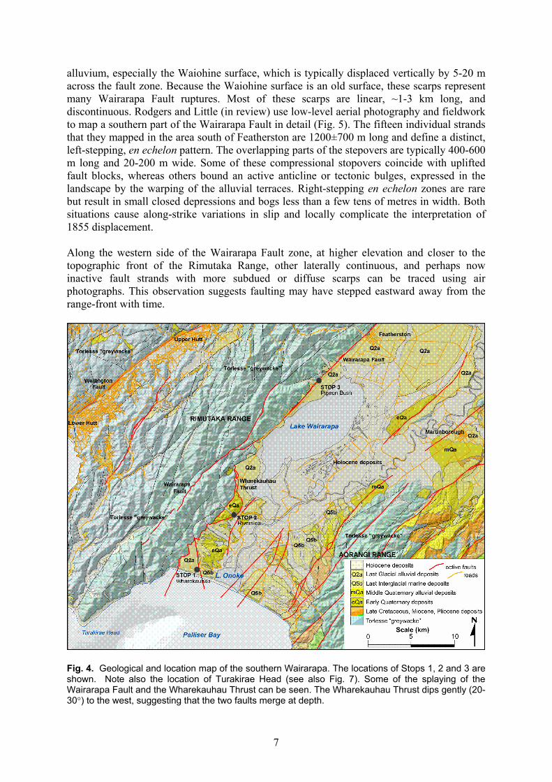
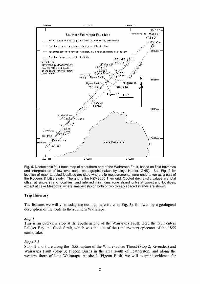
alluvium, especially the Waiohine surface, which is typically displaced vertically by 5-20 m across the fault zone. Because the Waiohine surface is an old surface, these scarps represent many Wairarapa Fault ruptures. Most of these scarps are linear, ~1-3 km long, and discontinuous. Rodgers and Little (in review) use low-level aerial photography and fieldwork to map a southern part of the Wairarapa Fault in detail (Fig. 5). The fifteen individual strands that they mapped in the area south of Featherston are 1200±700 m long and define a distinct, left-stepping, en echelon pattern. The overlapping parts of the stepovers are typically 400-600 m long and 20-200 m wide. Some of these compressional stopovers coincide with uplifted fault blocks, whereas others bound an active anticline or tectonic bulges, expressed in the landscape by the warping of the alluvial terraces. Right-stepping en echelon zones are rare but result in small closed depressions and bogs less than a few tens of metres in width. Both situations cause along-strike variations in slip and locally complicate the interpretation of 1855 displacement. Along the western side of the Wairarapa Fault zone, at higher elevation and closer to the topographic front of the Rimutaka Range, other laterally continuous, and perhaps now inactive fault strands with more subdued or diffuse scarps can be traced using air photographs. This observation suggests faulting may have stepped eastward away from the range-front with time.
Fig. 4. Geological and location map of the southern Wairarapa. The locations of Stops 1, 2 and 3 are shown. Note also the location of Turakirae Head (see also Fig. 7). Some of the splaying of the Wairarapa Fault and the Wharekauhau Thrust can be seen. The Wharekauhau Thrust dips gently (20-30°) to the west, suggesting that the two faults merge at depth.
8
Fig. 5. Neotectonic fault trace map of a southern part of the Wairarapa Fault, based on field traverses and interpretation of low-level aerial photographs (taken by Lloyd Homer, GNS). See Fig. 2 for location of map. Labeled localities are sites where slip measurements were undertaken as a part of the Rodgers & Little study. The grid is the NZMS260 1 km grid. Quoted dextral-slip values are total offset at single strand localities, and inferred minimums (one strand only) at two-strand localities, except at Lake Meadows, where smallest slip on both of two closely spaced strands are shown. Trip Itinerary The features we will visit today are outlined here (refer to Fig. 3), followed by a geological description of the route to the southern Wairarapa. Stop 1 This is an overview stop at the southern end of the Wairarapa Fault. Here the fault enters Palliser Bay and Cook Strait, which was the site of the (underwater) epicenter of the 1855 earthquake. Stops 2-3. Stops 2 and 3 are along the 1855 rupture of the Wharekauhau Thrust (Stop 2; Riverslea) and Wairarapa Fault (Stop 3; Pigeon Bush) in the area south of Featherston, and along the western shore of Late Wairarapa. At site 3 (Pigeon Bush) we will examine evidence for
9
unusually large coseismic fault-offsets (dextral) of small river channels during the 1855 earthquake and its precursor. Following Stop 3, we will have lunch, and then drive north of Featherston towards Greytown. Stop 4 This stop on the true left bank of Tauherenikau River to the west of Greytown. Here there are two fault scarps in proximity to one another. They dextrally offset a series of dry (long-abandoned) stream channels and terraces that lie well above the active channel of the river. Stop 5. Care must be taken at this stop on State Highway 2 to the north of Masterton. Here we view the 1855 scarp of the Wairarapa Fault and consider a huge 1855 landslide block in the distance at Kopuaranga. This is as far north on the trace of the Wairarapa Fault as we will get today. Stop 6. At Stop 6 we will examine a series of river terraces on the Ruamahanga River that have been backtilted as a result of the accumulation of earthquakes on the Mokonui Fault through time. We will then drive back towards Greytown, through Masterton. Stop 7. A short stop on the Masterton Fault examining one of several important splays or “offshoots” of the Wairarapa Fault that “shunt” some of its slip off to the east, thus distributing its earthquake potential into more eastern parts of the Wairarapa Valley. The drive from Wellington to Palliser Bay: Our route (Fig. 3) takes us along the motorway from Wellington to Upper Hutt. At Thorndon, the Wellington Fault enters the sea close to the Interislander ferry terminal, having passed through the Thorndon Overbridge and railway yards. Between Thorndon and Petone, the Wellington Fault lies submerged on the seafloor, just a few 100 m to our right. North of Petone, it returns to land. It is broadly expressed topographically here by a steep and densely bush-covered scarp in bedrock on the left hand side of the motorway. On the right side of the motorway, the active trace of the Wellington Fault is represented by a gentle southeast-facing slope on the far side of Hutt Road. Note the extensive beach deposits and Hutt River gravels accumulating beyond the scarp, on the downthrown side of the Wellington Fault. In this area, the valley floor is undergoing a net subsidence relative to sealevel at about 0.85 m/ka, and the Hutt River continues to aggrade its bed with gravel in response to this subsidence (Begg and Mazengarb, 1996; Begg et al. 2002). The valley becomes narrower towards the Taita Gorge, and bedrock rises from c. 300 m depth at the Petone foreshore to within 10 m of the valley floor at Silverstream Bridge. As soon as the Upper Hutt valley starts widening, the thickness of gravel and silt deposits beneath the valley floor increases rapidly, with bedrock at 199 m depth (below the valley floor) at Trentham Memorial Park. Quaternary deposits in the deepest part of the valley (on the western side) are thought to be 400-600 m deep (Melhuish et al. 1997). Like the Lower Hutt-Port Nicholson Basin, the Upper Hutt Basin is thought to be actively subsiding, possibly due to small variations in the strike of the Wellington Fault.
10
North of Upper Hutt, the road starts ascending the Rimutaka Range, passing through the Kaitoke pull-apart basin. This gravel-filled basin was controlled by a right-stepover in the Wellington Fault, which is here cutting eastward across the Rimutaka Range towards the eastern third of the Tararua Range. Note the outcrops of river gravels, often far above the present day valley floor, along the newly-realigned part of the road. The bedrock outcrops near Rimutaka Summit are late Triassic sediments (Torlesse “greywacke” and chert) and metabasalt (small patch of red weathering volcanic rock). Just before entering the town of Featherston, we cross the Wairarapa Fault to emerge onto the Plio-Pliestocene basin of the Wairarapa Valley. There we turn right (south) and head towards Palliser Bay while skirting the western shore of Lake Wairarapa, a structural depression on the down-thrown side of the Wairarapa Fault. The drive provides us with many opportunities to view Wairarapa Fault on our right. Typically the scarp is defined by an abrupt (5-20 m high) upward step in the cleared and terraced landscape. The active fault scarp typically lies just to the east of, and slightly below, the obvious slope-break at the foot of the Rimutaka Range. STOP 1. Palliser Bay Outlook and Waiohine surface From the Holocene beach deposits on the western shore of Lake Onoke, the road climbs through gravel of the early Quaternary Te Muna Formation onto a gently SE-inclined surface, cut as a flat bench by the sea during the Last Interglacial period, 125,000 to 80,000 years ago. Inclination and elevation of this bench is the result of subsequent deformation (Fig. 6). Behind, Lake Onoke and the distant coast of Palliser Bay leading south to Cape Palliser can be seen in the distance. Beyond the distant coastline across the bay is the forested Aorangi Range, underlain by Torlesse Terrane greywacke rock. Note the changing elevation of the Last Interglacial marine bench, and its reduction in elevation northward from its highest point at Cape Palliser (c. 200 m). The road in front climbs the Last Interglacial marine surface to an elevation of about 90 m before turning down a gully to Wharepapa Station, then across another gently sloping surface to the first stop. Here we will appreciate the beauty and geological significance of the coastal view from a point above the Palliser Bay Coast near Wharekauhau Station (now the site of a very swank US-owned resort). From this vantage point, Palliser Bay lies to the south beyond a coastline cliffed to the east in early Quaternary Te Muna Formation with a Last Interglacial cap, and to the west in Last Glacial gravel underlain by Last Interglacial marine sand and gravel. The boundary between these sequences is the Wharepapa Fault, now buried beneath the Waiohine gravel beneath us. About 2 km to the west, the Rimutaka Range rises abruptly beyond the Wharekauhau Thrust. The Wharekauhau Thrust, a southern offshoot of the Wairarapa Fault splays around the eastern flank of the Rimutaka Range hits the coast at “Te Mangonge” Stream. “Te Mangonge” Stream is an historic locality, described by Rodney Grapes in his book, “Magnitude 8 Plus” where, immediately after the 1855 earthquake, Edward Roberts a surveyor for the Royal Engineers and Clerk for Works observed a break along the creek, across which “the range of hills [Rimutaka Range] have gone up alone forming a perpendicular precipice of nine feet [2.7 m].” As a consequence of this uplift of the coastal rock platform, a coastal route negotiable by foot or ox-cart (or mountain bike) was opened up for the first time between the Wairarapa and Wellington. Charles Lyell met Roberts in England a year later, and included the surveyor’s account of 1855 co-seismic deformation into his book, “Principals of Geology, along with a cross-section of the “fault and fissure” in “Te Mangonge” Stream (Fig 7a). The maximum coastal uplift in 1855 occurred ~4 km to the

11
northeast of Turakirae Head, where the 1855 beach ridge was elevated vertically by 6.4 m on the upper block of the Wharekauhau Thrust (Hull and McSaveney, 1996; Begg and McSaveney) (Fig. 8). Turakirae Head preserves 3 other older ancient beach ridges festooned across the Holocene wave-cut platform like bath-tub rings, each progressively higher than the next. These record past earthquakes and sudden coastal uplift events, apparently similar in style and magnitude to the 1855 earthquake. The beach ridges have been dated by Hull and McSaveney (1996), who infer that the Wairarapa Fault (and Wharekauhau Thrust) has ruptured about every 1900 years on average during the past 7000 years, with the last event (prior to 1855) occurring between 110 and 430 BC. The coastal cliffs between Wharepapa Stream (immediately in front of us) and the Rimutaka Range consist of Last Glacial alluvium and silt, underlain by marine (?Last Interglacial) sand
Fig. 6. Geological map of the Wharekauhau area. Note the lobate or arcuate form of the surface trace of the Wharekauhau Thrust, and the age difference of deposits on either side of the Wharepapa Fault. The Wharepapa Fault cannot be seen at the surface, and cannot have been active since the end of the Last Glaciation. However, its presence and activity is defined by the elevation of the Last Interglacial surface on its eastern side, compared with the elevation of the Last Interglacial marginal marine sand and gravel in the riverbed (near sea level) below us. The fault is also recognized in gravity profiles across the area (Rollo 1992; McClymont 2000). The Last Interglacial marine bench on the eastern side of the fault dips to the east and is gently folded. Small red triangles are spot heights, labeled with their elevation in metres.

12
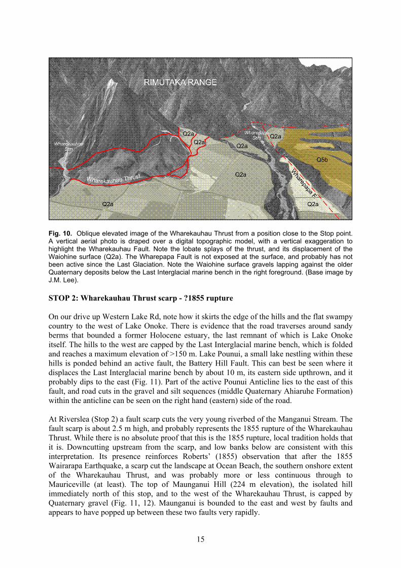
Fig. 7. Wharekauhau Thrust and Quaternary stratigraphy of western Ocean Beach, Palliser Bay. a) Illustration of "fault fissure" at “Te Mangonge” Stream from Charles Lyell’s Principals of Geology (1868, 10th ed.), according to which the rocks on the west side of the fault were, in 1855, elevated “alone forming a perpendicular precipice of nine feet.” This account was derived second-hand in 1856 from the colonial surveyor, Edward Roberts; b) Schematic cross-section of Wharekauhau Thrust on Palliser Bay coast from Grapes and Wellman (1993), with some of the stratigraphic interpretation from Schulmeister et al. (2000); c) Photograph of Q2a (Waiohine) surface showing folding above the Wharekauhau Thrust (looking north, taken on true left side of Wharekauhau Stream). and gravel. Below our vantage point, these gravels, and the older yellow marine sand can be seen in the roadcut and the stream floor (Fig. 9). The alluvial gravel at the surface here is an abandoned alluvial fan complex consisting of river gravel carried by streams from the uplifted Rimutaka Ranges. The river gravels we see in the road cut accumulated during a period of warming and sea-level rise following the Last Glacial maximum. In the Wairarapa Valley, this river aggradation phase typically ceased at ~10-12 ka, based on OSL dating by Wang (2001) and Formento-Trigilio et al. (2002). More recently, the rivers have been down-cutting into these gravels. The Waiohine surface, the surface of these deposits, provides an important geological marker with which to assess long-term (many 1000’s yrs; i.e., more than one earthquake) styles and rates of slip on the Wharekauhau and Wairarapa faults. Note that the Wharekauhau Thrust is a partially “buried” structure that does not always rupture the surface “sharply,” but which, in a more diffuse way, has also caused considerable folding of near-surface Quaternary deposits, including the Waiohine gravels (Figs. 7b and 7c, Fig. 10). The Waiohine surface (labeled as Q2a in Figs. 6, 7b, 10) has been vertically displaced by ~20

13
m across the Wharekauhau Thrust. Dating near this site constrains its age to the interval ~12.5-5 ka, consistent with a mean vertical slip-rate (up to the west) of 1.6 – 4 mm/yr (a rate of ~1.5-2 mm/yr seems most likely).
Fig. 8. Oblique aerial view, looking northeast, of the uplifted beach ridges at Turakirae Head. The ridges have been dated using 14C (radiocarbon) and Be10 surface exposure dating techniques (Hull and McSaveney, 1996; McSaveney et al. submitted). Here, 2 km SW of the axis of greatest uplift in 1855, BR2 was raised 4.7 m in 1855, BR3 was raised 7.1 m in the event prior to 1855, BR4 was raised 3.7 m in the earthquake before that, and BR5 was raised 3.4 m in the earliest Holocene earthquake recorded here. In the distance, at least two raised marine benches (analogous with the Holocene bench in the foreground) can be seen in the coastal profile. Suggested age correlations for these benches are based on high sea level stands of the international sea level curve. (Photo by Lloyd Homer, GNS) Behind us, beyond Wharepapa Station, these outwash gravels lap against the early Quaternary Te Muna Formation gravel and silt deposits that underlie the Last Interglacial surface (and deposits). This, relationship, late Last Glacial gravels lapping against an older marine bench to the east, the elevation difference of Last Interglacial deposits on each side of the fault, and the presence of a significant negative gravity anomaly near the same contact, points to the presence of a buried fault down Wharepapa Stream (e.g., Kingma1967; Rollo 1992; Begg and Mazengarb 1996; McClymont 2000).

14
Fig. 9. A measured section of the deposits underlying the Waiohine surface at the mouth of Wharekauhau Stream. This section is typical of the sequence found in the coastal cliffs west of the Wharepapa Fault. Note the sharp contact near the base of the section marking a change from marine to non-marine deposits. The scale on the left is thickness in metres.
15
Fig. 10. Oblique elevated image of the Wharekauhau Thrust from a position close to the Stop point. A vertical aerial photo is draped over a digital topographic model, with a vertical exaggeration to highlight the Wharekauhau Fault. Note the lobate splays of the thrust, and its displacement of the Waiohine surface (Q2a). The Wharepapa Fault is not exposed at the surface, and probably has not been active since the Last Glaciation. Note the Waiohine surface gravels lapping against the older Quaternary deposits below the Last Interglacial marine bench in the right foreground. (Base image by J.M. Lee). STOP 2: Wharekauhau Thrust scarp - ?1855 rupture On our drive up Western Lake Rd, note how it skirts the edge of the hills and the flat swampy country to the west of Lake Onoke. There is evidence that the road traverses around sandy berms that bounded a former Holocene estuary, the last remnant of which is Lake Onoke itself. The hills to the west are capped by the Last Interglacial marine bench, which is folded and reaches a maximum elevation of >150 m. Lake Pounui, a small lake nestling within these hills is ponded behind an active fault, the Battery Hill Fault. This can best be seen where it displaces the Last Interglacial marine bench by about 10 m, its eastern side upthrown, and it probably dips to the east (Fig. 11). Part of the active Pounui Anticline lies to the east of this fault, and road cuts in the gravel and silt sequences (middle Quaternary Ahiaruhe Formation) within the anticline can be seen on the right hand (eastern) side of the road. At Riverslea (Stop 2) a fault scarp cuts the very young riverbed of the Manganui Stream. The fault scarp is about 2.5 m high, and probably represents the 1855 rupture of the Wharekauhau Thrust. While there is no absolute proof that this is the 1855 rupture, local tradition holds that it is. Downcutting upstream from the scarp, and low banks below are consistent with this interpretation. Its presence reinforces Roberts’ (1855) observation that after the 1855 Wairarapa Earthquake, a scarp cut the landscape at Ocean Beach, the southern onshore extent of the Wharekauhau Thrust, and was probably more or less continuous through to Mauriceville (at least). The top of Maunganui Hill (224 m elevation), the isolated hill immediately north of this stop, and to the west of the Wharekauhau Thrust, is capped by Quaternary gravel (Fig. 11, 12). Maunganui is bounded to the east and west by faults and appears to have popped up between these two faults very rapidly.

16
Fig. 11. Geological map of the Manganui Stream area. Note that the Wharekauhau Thrust here includes an eastern and a western splay, with the hill Maunganui between. Maunganui is underlain by early Quaternary deposits and capped by alluvial gravel of middle Quaternary age. The Battery Hill Fault is obscured by late Holocene deposits along much of its length, but offset of the Last Interglacial marine bench at Battery Hill, and folding of the Pounui Anticline indicate the activity of the structures. A folded and abandoned Last Glacial river course of Manganui Stream crosses the axis of the Pounui Anticline. Holocene deposits in the Ruamahanga River area to the east are estuarine to marginal marine in origin. Small red triangles are spot heights, labeled with their elevation in metres. On the drive northwards, views of scarps of the Wharekauhau Thrust can be seen at the foot of the range from the road. The strike-slip Wairarapa Fault cuts across and emerges from the Rimutaka Range close to where the Waiorongomai River debouches from the hills. Here it unites with the Wharekauhau Thrust, and northwards the Wairarapa Fault is predominantly strike-slip in nature. STOP 3. Pigeon Bush Area From the Waiorongomai River, the rangefront closes obliquely on the road, and a sharp scarp, probably the 1855 rupture, cuts across the paddocks to the road. From here, the road follows close to the fault scarp around the western margin of Lake Wairarapa for c. 2.5 km, before the shore swings further eastward away from the road, around fans of the Waiohine gravel.

17
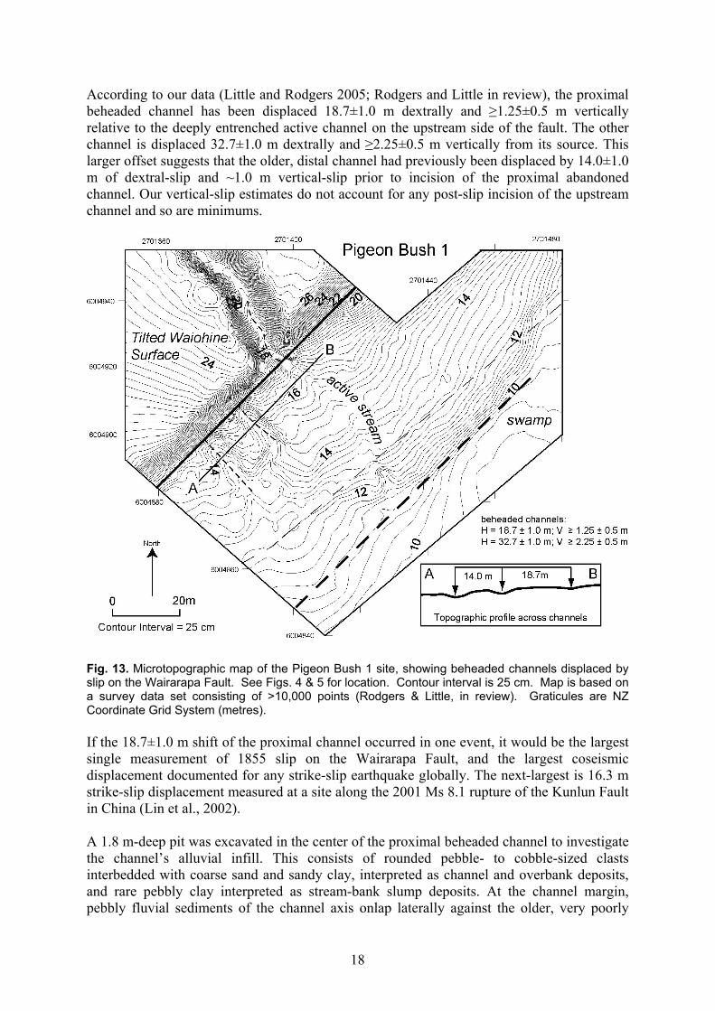
Fig. 12. Oblique elevated image of the Manganui Stream area. The vertical scale is considerably exaggerated. Note the truncation of the Last Interglacial marine bench by the Wharekauhau Thrust (Q5b, left foreground) and the location of the 1855 trace across Manganui Stream (Stop 2). Note also the Pounui Anticline, capped by the raised and folded Last Interglacial marine bench. The marine bench is bisected by an abandoned Last Glacial Manganui Stream course. (Base image by J.M. Lee). Pigeon Bush 1 Pigeon Bush is justifiably the most famous geological site on the Wairarapa Fault. There, Grapes and Wellman (1988) interpreted two well-preserved, beheaded streams as evidence of dextral offset of a small stream gully cross-cutting the Wairarapa Fault during two sequential earthquake events, most recently in 1855. The fault is marked by a SE-facing scarp cut into Waiohine gravel (Fig. 13). On the uplifted (NW) side of the fault, the Waiohine gravels have been back-tilted to the southwest by ~5° on the limb of an anticlinal bulge that crests to the NE of this site. Over time, this tilting has diverted some of the stream’s headwaters southward into an adjacent stream. Thus the gorge on the up-thrown side of the scarp now seems disproportionately deep with respect to the small, low-discharge stream that currently flows within it. This is important because the stream flows through an entrenched gorge that is, in a sense, partially abandoned and thus little modified since its displacement along the fault. As recognized by Grapes and Wellman (1988), the exceptionally well-preserved geomorphology of beheaded streams at Pigeon Bush supports the idea that this younger increment of slip accrued during a single event, rather than as a composite displacement involving one or more intermediate stages. Both of the beheaded channels on the downstream side of the fault retain a linear morphology all the way up to the fault, where they are abruptly and orthogonally truncated against the scarp. Similarly, the source gorge on the upstream side does not widen significantly at the fault, but remains narrow, linear, and fault-transverse all the way to the scarp. There is no evidence for a paleo-channel ever having run along the fault scarp between the modern stream and either of the abandoned channels, as might reflect an intermediate phase of stream dog-legging induced by shutter ridge damming. On the downthrown side, the terrace gravels are overlain by a scarp-derived apron of colluvium.
18
According to our data (Little and Rodgers 2005; Rodgers and Little in review), the proximal beheaded channel has been displaced 18.7±1.0 m dextrally and ≥1.25±0.5 m vertically relative to the deeply entrenched active channel on the upstream side of the fault. The other channel is displaced 32.7±1.0 m dextrally and ≥2.25±0.5 m vertically from its source. This larger offset suggests that the older, distal channel had previously been displaced by 14.0±1.0 m of dextral-slip and ~1.0 m vertical-slip prior to incision of the proximal abandoned channel. Our vertical-slip estimates do not account for any post-slip incision of the upstream channel and so are minimums.
Fig. 13. Microtopographic map of the Pigeon Bush 1 site, showing beheaded channels displaced by slip on the Wairarapa Fault. See Figs. 4 & 5 for location. Contour interval is 25 cm. Map is based on a survey data set consisting of >10,000 points (Rodgers & Little, in review). Graticules are NZ Coordinate Grid System (metres). If the 18.7±1.0 m shift of the proximal channel occurred in one event, it would be the largest single measurement of 1855 slip on the Wairarapa Fault, and the largest coseismic displacement documented for any strike-slip earthquake globally. The next-largest is 16.3 m strike-slip displacement measured at a site along the 2001 Ms 8.1 rupture of the Kunlun Fault in China (Lin et al., 2002). A 1.8 m-deep pit was excavated in the center of the proximal beheaded channel to investigate the channel’s alluvial infill. This consists of rounded pebble- to cobble-sized clasts interbedded with coarse sand and sandy clay, interpreted as channel and overbank deposits, and rare pebbly clay interpreted as stream-bank slump deposits. At the channel margin, pebbly fluvial sediments of the channel axis onlap laterally against the older, very poorly

19
sorted sediments of the colluvial apron into which the fluvial channel is incised. Wang (2001) OSL dated two samples of this poorly-sorted colluvial silt, obtaining ages of 4.3±0.5 ka and 7.0±0.5 ka. Formation of the proximal beheaded channel is thus interpreted to involve an initial stage of stream incision into the colluvial substrate, followed by partial infilling of the channel by at least 1.8 m of alluvium, and ending with stream channel abandonment. Charcoal from depths of 15 cm and 154 cm yielded calibrated ages of AD 1364±63 and AD 1355±60 (all dates are 2σ intervals), a similarity that suggests that the channel was infilled rapidly, perhaps as a consequence of a burning and deforestation event in its headwaters. We infer that the stream was not only active ~500 years before the 1855 earthquake, but that it was also capable of moving and depositing gravel. Thus 18.7 m offset and beheading of this small stream must have taken place sometime after this. Because the geomorphology implies that the proximal channel was displaced to its current position as the result of a single event, and because the data in the Tea Creek Road trench (Van Dissen and Berryman, 1996) and at Cape Turakirae (Hull and McSaveney, 1996) do not identify any surface rupturing event on the Wairarapa Fault between 1855 and 1400-1530 cal yrs BP., we infer that the 18.7±1.0m offset at Pigeon Bush took place entirely in 1855. A 1.6 m-deep pit was excavated in the center of the distal beheaded channel, in hopes that an abandonment age for this channel would date the penultimate earthquake on the Wairarapa Fault. However, the pit consisted entirely of massive pebbly clay of the colluvial substrate, so this older channel appears to be an erosional feature lacking fluvial infill. Despite the lack of age control on the distal channel, the 14.0±1.0 m distance between it and the proximal channel is most simply interpreted to record a single pre-1855 increment of co-seismic slip coincident with the penultimate surface rupture on the Wairarapa Fault. Pigeon Bush 2 This region includes offsets E5 and E6 described by Grapes and Wellman (1988), and is located <1 km northeast of Pigeon Bush 1 (Fig. 14). Here the fault is characterized by a scarp that coincides with an abrupt southeast-facing topographic step and two elongate topographic depressions. A second strand marked by a small, southeast-facing topographic step may occur to the southeast of the main one, and a third may be present ~100 m to the northwest, but neither of these coincides with any fresh scarps or has revealed any evidence of recent slip. Two small streams are incised 1.0 to 4.5 m into the older terrace alluvium and are dextrally displaced across the fault (Fig. 14). Where the streams cross the fault trace they deflect abruptly to the southwest to flow parallel to the fault before deflecting back to the southeast again on the downthrown side of the fault. Linear axes were defined along these incised channels and their dextral offset was restored with the aid of a microtopographic map. A narrow fluvial terrace remnant is preserved on the NW side of the western of the two streams (Stream B). Its 0.75±0.25 m of incision by the modern stream on the NW side of the fault, and the 1.25±0.25 m of vertical-offset of stream channel B across the fault together suggest ~2 m of vertical-slip (interpreted as a minimum, as this sum does not account for any post-1855 deposition that may have partially infilled the channel on the on SE side). Dog-legging of this southwestern stream implies 13.0±1.5 m of dextral-slip, whereas dog-legging of the other active stream to the NE records 27.4 ±1.5 of dextral-slip. Following Grapes and Wellman (1988), we interpret the smaller stream offset to have accumulated in 1855 and the larger one to record a summation of slip during both 1855 and the next-older (penultimate) earthquake. This two-increment model of slip accumulation is strongly supported by recent discovery of a subtle abandoned stream channel on the downthrown side of the fault to the

20
southwest of the SW active stream. The beheaded stream channel is dextrally offset by 26.3±5.0 m from its incised source: thus both of the small streams preserve evidence for a ~26-27 m horizontal slip, and one of the streams, similar to the nearby Pigeon Bush 1 site, also preserves evidence for a younger and smaller increment of offset.
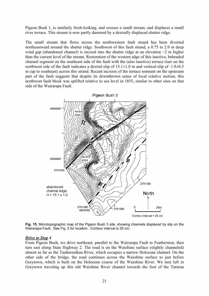
Fig. 14. Microtopographic map of the Pigeon Bush 2 site, showing channels displaced by slip on the Wairarapa Fault. See Fig. 5 for location. Contour interval is 25 cm. Pigeon Bush 3 About 300 m southwest of Pigeon Bush 1 is a newly recognized site featuring a beheaded channel on the southeast side of the fault that has been dextrally offset relative to an active channel segment on the upstream side (Fig. 15). At this locality, the Wairarapa Fault zone is ~50 m wide, comprising a 2 m high, southeast-facing fault scarp to the southeast and a 2 m high, northwest-facing fault scarp to the northwest (Fig. 15). The southeast strand is characterised by a linear, southeast-facing topographic step, though it is unclear whether this segment slipped in 1855. The northwestern strand is continuous with the main scarp at
21
Pigeon Bush 1, is similarly fresh-looking, and crosses a small stream, and displaces a small river terrace. This stream is now partly dammed by a dextrally displaced shutter ridge. The small stream that flows across the northwestern fault strand has been diverted northeastward around the shutter ridge. Southwest of this fault strand, a 0.75 to 2.0 m deep wind gap (abandoned channel) is incised into the shutter ridge at an elevation ~2 m higher than the current level of the stream. Restoration of the western edge of this inactive, beheaded channel segment on the southeast side of the fault with the (also inactive) terrace riser on the northwest side of the fault indicates a dextral-slip of 15.1±1.0 m and vertical-slip of -1.8±0.5 m (up to southeast) across this strand. Recent incision of the terrace remnant on the upstream part of the fault suggests that despite its downthrown sense of local relative motion, this northwest fault block was uplifted relative to sea level in 1855, similar to other sites on that side of the Wairarapa Fault.
Fig. 15. Microtopographic map of the Pigeon Bush 3 site, showing channels displaced by slip on the Wairarapa Fault. See Fig. 5 for location. Contour interval is 25 cm. Drive to Stop 4 From Pigeon Bush, we drive northeast, parallel to the Wairarapa Fault to Featherston, then turn east along State Highway 2. The road is on the Waiohine surface (slightly channeled) almost as far as the Tauherenikau River, which occupies a narrow Holocene channel. On the other side of the bridge, the road continues across the Waiohine surface to just before Greytown, which is built on the Holocene course of the Waiohine River. We turn left in Greytown traveling up this old Waiohine River channel towards the foot of the Tararua

22
Range. The road climbs up a terrace riser back onto the Waiohine surface just before Woodside. Underhill Rd traverses the Waiohine gravel fan to the Tauherenikau River. STOP 4. Tauherenikau River This location, first described by Grapes and Wellman, is ~10 km north of Pigeon Bush 1 (Figs. 2, 3 and 16). The site is important because the fault, here consisting of two-strands, cuts across a series of exceptionally well-preserved, abandoned river channels that provide excellent linear markers of fault offset, and because one of the channels offset by the fault is infilled by swamp deposits containing dateable organic material. The two strands of the Wairarapa Fault at this site strike ~048° and displace an inactive river terrace on the north bank of the Tauherenikau River. The southeastern strand is marked by a southeast-facing, 3-4 m high scarp that exposes steep, planar outcrops of the unconsolidated pebble and cobble gravels that underlie the terrace tread. The northwestern strand has a ~1 m high, northwest-facing scarp, lacks fresh exposures of the underlying gravel, and is more subdued-looking. The two fault splays cut across three abandoned stream channels that gently meander across the broad river terrace. A microtopographic map of the entire fault zone (Fig. 16) allows the edges or thalwegs of fault-displaced segments of these inactive channels to be projected to the adjacent faults. Restoration of the displaced channel segments back into linear continuity indicates that the steeper and fresher-looking southeastern fault strand has accomplished an average dextral-slip of 16.0±1.5 m of and an average vertical displacement of 3.8±1.0 m. The northwestern fault strand accomplished an average of 8.5±1.0 m of dextral slip and -0.4±0.2 m of vertical slip. Our dextral-slip value for the southeastern fault is greater than the 12.5 m reported by Grapes and Wellman (1998) and Grapes (1999), while our measured dextral-slip on the northwestern fault is similar to the 8.0 m reported by them. Offset of each of the three abandoned stream channels is similar along both of the two fault strands, evidence that slip on both of the faults completely post-dates the incision and abandonment of all three of the channels. Moreover, the contrast in scarp morphology suggests the southeastern fault is younger than the northwestern fault, unless the latter has experienced a faster rate of scarp degradation (perhaps due to its northwest facing direction). The age of last activity on the southeastern fault is potentially recorded by the accumulation of sediment locally on its downthrown side. There, one of the displaced channel segments is now the site of an active swamp that has filled with organic clay, peat, and matted vegetation above the older terrace gravel. These organic-rich sediments occur only on the southeast, downthrown segment of this abandoned channel. On the other side of the fault, the same channel is dry, exposing cobbles of terrace alluvium on its floor. We interpret the swamp deposits to be a consequence of earthquake-related slip that caused the abandoned channel on the downthrown, southeast side of the fault to be displaced downward across the water table. A consequence of this slip was incursion of groundwater into the low topography at the base of the channel. Two samples of peat were collected with a peat-corer from the basal clay layer directly overlying terrace gravel at depths below water level of 75-85 cm and 72-82 cm, and yielded calibrated dates of AD 1709±26 (27% probability) or 1869±60 (71% probability) for one sample and AD 1723±49 (34% probability) or 1871±70 (64% probability) for the other. While not providing a unique interpretation, these 14C ages are consistent with an 1855 age of groundwater incursion and swamp initiation along the fresh-looking southeast fault scarp, and, by inference, for the 16.0±2.0 m of dextral-slip measured on that strand having accumulated as part of a single event in 1855.

23
Fig. 16. Aerial photograph and detailed survey map of the Tauherenikau River site, showing fault scarps and abandoned channels displaced by slip on the Wairarapa Fault. See Fig. 2 for location. Contour interval is 25 cm.

24
STOP 5: Scarp at the northern end of the Wairarapa Fault From the Tauherenikau River, the road passes across the Waiohine surface and Holocene river gravel to Greytown where we rejoin State Highway 2. The main road crosses the old Holocene and present day river course of the Waiohine River, before climbing back onto the Waiohine surface c. 2.5 km short of Carterton. Although not visible from the road, to the SE of Carterton, Last Interglacial gravel and silt are exposed in the core of a very gentle anticline (Warnes 1989). From here, our road remains on the Waiohine surface all the way to Oldfields gravel works on the SW side of the Waingawa River. The road ramps onto the Waiohine surface on the east abutment of the bridge over the Waingawa River, and we turn left onto the Masterton bypass. Within a few hundred metres, the road climbs the gentle 3.5 m high scarp of the Masterton Fault, upthrown on the NW, at Solway School. The bypass road and State Highway 2 continue on the Waiohine surface almost continuously (except for c. 1 km on Holocene deposits of the Waipoua River) all the way to the next stop, at the Mikimiki Rd turnoff. On the way, near Opaki, we climb the 15 m high scarp of the Mokonui Fault, the northernmost of 3 or 4 faults (the Carterton, Masterton, Mokonui faults and perhaps the Kaumingi Fault) that splay eastward from the Wairarapa Fault. As the bus approaches the next stop, we get a view across the Ruamahanga River (to the right of the bus) of a large landslide, reputedly (although not certainly) caused by the 1855 Wairarapa Earthquake ground shaking (Grapes and Downes 1997). At least one verbatim record (Bannister 1940) indicates that the landslide dammed the river for some time and that when the dam breached a torrent of water flooded the valley below. The trace of the Wairarapa Fault crosses State Highway 2 at the Mikimiki Rd turnoff and is about 7.5 m in height. The scarp can be seen clearly on the SW side of the road, forming a little-degraded bank. The terrace gravel displaced here is Waiohine gravel, about 10-15 ka in age. The scarp must be a compound one, its 8 m height comprising contributions from many Wairarapa Fault ruptures subsequent to the surface being raised beyond the influence of the Ruamahanga River (immediately to the east). Subtle changes in the scarp profile between the rounded base, a steepened central zone about 1.5-2 m in height, and a rounded upper zone may distinguish older ruptures from the 1855 one. STOP 6: - Backtilted alluvial gravels The road south follows a remnant tongue of the Waiohine surface. The surface is displaced across the Mokonui Fault at the turnoff to Mauriceville. Active traces of the Mokonui Fault cross young river terraces near Twin Bridges, are upthrown to the northwest, and indicate that the fault is active. Pliocene limestone (Mangamahoe Limestone; Waipipian stage) crops out on the eastern river bank upstream from the fault, also indicating uplift on the northwest side. Opaki-Kaipororo Road follows the eastern bank of the Ruamahanga River for three kilometres, then we turn right up Millers Rd to a stop near the end of the road (Fig. 17). The view to the NW is up the Ruamahanga Valley down terrace surfaces that have been backtilted tectonically by deformation associated with the Mokonui Fault. The Mokonui Fault is a c. 20 km long active fault splaying from the Wairarapa Fault from near Tea Creek. It is thought to be largely strike-slip in nature along most of its length, and is mostly downthrown to the southeast or east. As it bends northwards from near Hawkhurst,

25
the dip-slip component becomes more significant and at Hawkhurst itself, the fault is marked by an 18 m high scarp with ponding on the downthrown surface. While some slip is carried northeastwards, some scarps curve from striking NE to strike north on the eastern side of the Ruamahanga River, where the backtilted terraces suggest a reverse component of slip. A series of splays strike along the Opaki-Kaipororo Rd towards the northern extent of the Wairarapa Fault. Trenching (Fig. 17) indicates that at least two surface-rupturing events have occurred on the Mokonui Fault in the last 4 ka, and probably at least 4 in the last 12 ka, giving a recurrence interval of about 1,300-2,000 yrs (Langridge et al. 2003). The same authors estimated a slip rate of 0.5-0.7 mm/yr (Table 1).
Fig. 17. Geological map of the northern Wairarapa Fault area with the locations of stops 5,6 and 7. Note the active Carterton, Masterton and Mokonui faults splaying eastward from the Wairarapa Fault, and the location of trench sites on each of these faults. Also note that the Wairarapa Fault itself cuts eastward away from the greywacke range front. “Hooked” eastern portions of the Mokonui and Masterton faults are probably reverse in nature, resulting in back-tilting of older alluvial gravel terraces immediately east of the Ruamahanga on the Mokonui Fault, and west of the Ruamahanga River on the Masterton Fault. Stop 6 is close to the tip of this part of the Mokonui Fault. The view to the north and east is of a wide valley with an underfit stream, the Kopuaranga River, an abandoned course of the Ruamahanga River. Tilting associated with the Mokonui Fault has diverted the river to its present course in the west. The age of the tilted gravel surfaces is uncertain, although augering near here suggests that the youngest is probably Q4 in age (c. 70-50 ka). Diversion of the river to its present course probably occurred during the middle part of the Last Glaciation (Q3, 50-28 ka).

26
STOP 7: The Masterton Fault Our continuation down the valley to Masterton follows the Waiohine surface to just south of the turnoff to Rathkeale College, after which we climb imperceptibly to a Q4 surface. On the left side of the bus, low hills capped by surfaces dipping to the northwest are analogous to those we have just seen on the northwest side of the Mokonui Fault. These ones, on the outskirts of Masterton, are backtilted by the Masterton Fault. The Masterton Fault crosses State Highway 2 with a gentle scarp close to Miro Street, the first street on the right (west) within the urban area. Our route takes us across the Waipoua River, just before which, we step down onto an early Holocene alluvial surface, then along Chapel Street to Renall Street, where we climb imperceptibly back onto the Waiohine surface. Here, the low Masterton Fault scarp can be seen again on the right hand side of the bus. The road continues southwest to the Waingawa Bridge, completing a round trip. The last stop of the day is at the Masterton Fault scarp on Norfolk Rd. After climbing onto the Waiohine surface, we turn right onto Norfolk Rd and continue northwest across the railway line to the prominent 5.2 m high scarp, downthrown to the south. A break in the profile of the scarp to the northeast of the road suggests that it represents at least two rupture events. A trench across the fault c. 1.5 km to the west behind the old freezing works buildings, failed to provide useful information on the fault, although its stratigraphy was consistent with at least two rupture events since the terrace’s alluvial abandonment (10-15 ka; Begg et al. 2001). The earthquake characteristics of the Masterton Fault proved difficult to determine. Begg et al. (2001) concluded that there was probably a component of normal-slip. In the absence of lateral offsets of landscape features, Zachariasen et al. (2000) inferred that the Masterton Fault’s principal slip component is strike-slip on the basis of similarity of strike and landscape expression to the Carterton and Mokonui faults. Because, neither Zachariasen et al. (2000) nor Begg et al. (2001) could derive data constraining the single event displacement or timing of the last (or any other) event, they were forced to rely on international relationships between fault length and single event displacements (Wells and Coppersmith 1994) to characterise the fault. While we have no additional information to present, there is general agreement that the single event displacement presented by Begg et al. (2001) is atypically small for New Zealand strike-slip faults, resulting in far too short a recurrence interval (1 ka). A relationship more realistic for New Zealand faults has been developed (Webb, Berryman et al. in prep) and, with additional work to locate and capture new data, should be applied to these faults. Table 1: Summary of the characteristics of rupture for the Carterton, Masterton and Mokonui faults based on the work of Zachariasen et al. (2000), Begg et al. (2001), Townsend et al. (2002) and Langridge et al. (2003). Note that values marked with an asterisk are almost certainly underestimates of real values and should be revised using the relationships of Webb, Berryman et al. (in prep). The values marked ** probably underestimate the return period, particularly that for the Masterton Fault, because of their reliance on single event displacement data.
Fault Vertical slip rate (mm/yr)
Horizontal slip rate (mm/yr)
Single event displacement (m)
Recurrence interval (ka)
Approx. Magnitude
(Mw)
Source
Carterton Fault 0.15 2 1* 1-2** 7.0 Begg et al. (2001)
Masterton Fault 0.5 >0.5 >0.5* >1** 6.7 Begg et al. (2001)
Mokonui Fault 0.2-0.5 >0.3-0.7 0.5-0.7* 1.3-2.0** 6.7 Langridge et al. (2003)

27
References
Bannister, C., 1940, “Early history of the Wairarapa”. Masterton Printing Company. Masterton, New Zealand. Barnes, P. M., and Mercier de Lepinay, B., 1997, Rates and mechanics of rapid frontal accretion along the very
obliquely convergent southern Hikurangi margin, New Zealand: Journal of Geophysical Research, v. 102, No. B11, p. 24,931-24,952.
Barnes, P. M., and Audru, J.-C., 1999, Quaternary faulting in the offshore Flaxbourne and Wairarapa Basins, southern Cook Strait, New Zealand: New Zealand Journal of Geology and Geophysics, v. 42, p. 349-367.
Begg, J.G., and Mazengarb, C. 1996, Geology of the Wellington area, scale 1:50,000. Institute of Geological and Nuclear Sciences geological map 22.
Begg, J. G., and Johnston, M. R., 2000, Geology of the Wellington area, New Zealand: Institute of Geological and Nuclear Sciences, Ltd., Geological Map 64 (1:250,000).
Begg, J.G., Villamor, P., Zachariasen, J., Litchfield, N., 2001, Paleoseismic assessment of the active Masterton and Carterton faults, Wairarapa. GNS Client Report 2001/70. (For Wairarapa Engineering Lifelines Association).
Begg, J.G., Van Dissen, R.J., Rhoades, D.A., Lukovic, B., Heron, D.W., Darby, D.J., Brown, L.J., 2002, Coseismic subsidence in the Lower Hutt Valley resulting from rupture of the Wellington Fault. GNS Client Report 2002/140 (for Earthquake Commission).
Begg, J.G., McSaveney, M.J., 2005, Wairarapa Fault rupture – vertical deformation in 1855 and a history of similar events from Turakirae Head. The 1855 Wairarapa Earthquake Symposium Proceedings Volume. Greater Wellington Regional Council publication GW/RINV-T-05/206.
Darby, D. J., and Beanland, S., 1992, Possible source models for the 1855 Wairarapa Earthquake, New Zealand: Journal of Geophysical Research, v. 97(B9), p. 12375-12389.
Darby, D.J., and Beavan, J. 2001, Evidence from GPS measurements for contemporary interplate coupling on the southern Hikurangi subduction thrust and for partitioning of strain in the upper plate: Journal of Geophysical Research, v.106, p. 30881-30891.
DeMets, C., Gordon, R.G., Argus, D.F. and Stein, S., 1990, Current plate motions. Geophysical Journal 101: 425-478.
DeMets, C., Gordon, R.G., Argus, D.F., Stein, S., 1994, Effect of recent revisions to the geomagnetic reversal time scale on estimates of current plate motions. Geophysical Research Letters 21: 2191-2194.
Downes, G., and Grapes, 1999, The 1855 Wairarapa Earthquake, New Zealand – historical data: GNS Science Report 99/16, 267 pp.
Dowrick, D.J., 1992, Attenuation of Modified Mercalli intensity in New Zealand earthquakes: Earthquake engineering and structural dynamics, v. 21, p. 182-196.
Formento-Trigilio, M.L., Burbank, D.W., Nicol, A., Shulmeister, J. & Rieser, U. 2002: River response to an active fold and thrust belt in a convergent margin setting, North Island, New Zealand. Geomorphology 49, 125-152.
Grapes, R., 1999, Geomorphology of faulting: the Wairarapa fault, New Zealand: Z. Geomorphology, v. 115, p. 191-217.
Grapes, R. H., and Downes, G., 1997, The 1855 Wairarapa, New Zealand, Earthquake- analysis of historical data: Bulletin of the New Zealand National Society of Earthquake Engineering, v. 30, p. 271-369.
Grapes, R. H., and Wellman, H. W., 1988, The Wairarapa Fault: Victoria University of Wellington Geology Board of Studies, v. 4, p. 54.
Grapes, R., and Wellman, H. W., 1993, Wharekauhau Thrust (Palliser Bay) and Wairarapa Fault (Pigeon Bush) [Field-trip Guide]: Geological Society of New Zealand Miscellaneous Publication, v. 79B, p. 27-44.
Kingma, J.T., 1967, Sheet 12, Wellington. Geological map of New Zealand, 1:250,000. Department of Scientific and Industrial Research, Wellington, New Zealand.
Langridge, R.M., Townsend, D., Persaud, M. 2003, Paleoseismic assessment of the active Mokonui Fault, Wairarapa. GNS Client Report 2003/68. (For Wairarapa Engineering Lifelines Association).
Langridge, R.M., Van Dissen, R.J., Cochran, U.A., Litchfield, N.J., Berryman, K.R., Begg, J.G., Villamor, P., Heron, D.W., Nicol, A., Townsend, D.B., 2005, Active faulting and paleoearthquakes in the Wairarapa and Wellington regions. The 1855 Wairarapa Earthquake Symposium Proceedings Volume. Greater Wellington Regional Council publication GW/RINV-T-05/206.
Lensen, G.J., and Vella, P., 1971, The Waiohine River faulted terrace sequence, in Recent Crustal Movements: Bulletin Royal Society of New Zealand, v. 9, p. 117-119.
Lin, A., Fu, B., Guo, J., Zeng, Q., Deng, G., He, W., and Zhao, Y., 2002, Co-seismic strike-slip and rupture length produced by the 2001 Ms 8.1 Central Kunlun earthquake: Science, v. 296, p. 2015-2017.
28
Little, T.A., Rodgers, D.W., 2005, Co-seismic slip during the 1855 Earthquake, southern Wairarapa Fault, New Zealand. The 1855 Wairarapa Earthquake Symposium Proceedings Volume. Greater Wellington Regional Council publication GW/RINV-T-05/206.
Hull, A.G. and McSaveney, M.J. 1996, A 7000-year record of great earthquakes at Turakirae Head, Wellington, New Zealand. GNS Client Report 33493B.10 (for Earthquake Commission).
Lyell, C., 1868, “Principals of geology or the modern changes of the Earth and its inhabitants”. 10th edition. London, England. John Murray.
McClymont, A.F., 2000, A gravity survey of the Wharekauhau Thrust, Palliser Bay, New Zealand. New Zealand Journal of Geology and Geophysics 43: 303-306.
McSaveney, M.J., Graham, I.J., Begg, J.G., Beu, A.G., Hull, A.G., Kim, Keong, Zondervan, A., (submitted), Late Holocene uplift of beach ridges at Turakirae Head, south Wellington coast, New Zealand. New Zealand Journal of Geology and Geophysics.
Melhuish, A., Begg, J.G., Bannister, S., Mumme, T., 1997, Quaternary stratigraphy, structure, and deformation of the Upper Hutt Basin, Wellington, New Zealand. New Zealand Journal of Geology and Geophysics
Rollo, J., 1992, Geophysical investigations of the southwestern Wairarapa region of New Zealand. Unpublished MSc thesis, Victoria University of Wellington. Wellington, New Zealand.
Rodgers, D. W., and Little, T. A., in review, Very large co-seismic slip associated with 1855 rupture of the Wairarapa Fault, New Zealand.
Schermer, E. R., Van Dissen, R., Berryman, K. R., Kelsey, H. M., and Cashman, S. M., 2004, Active faults, paleoseismology, and historical fault rupture in northern Wairarapa, North Island: New Zealand Journal of Geology and Geophysics, v. 47, p. 107-122.
Schulmeister, J. and Grapes, R.H., 2000, Gravel aggradation during interglaciations: implications from Palliser Bay, southern North Island, New Zealand. Geological Society of New Zealand. New Zealand Geophysical Society Joint Annual Conference, 27-30 November 2000. Geological Society of New Zealand Miscellaneous Publication 108A: p.140.
Townsend, D., Begg, J.G., Villamor, P., Lukovic, B., 2002, Late Quaternary displacement of the Mokonui Fault, Wairarapa, New Zealand: A preliminary assessment of earthquake generating potential. GNS Client Report 2002/58. (For Wairarapa Engineering Lifelines Association).
Van Dissen, R. J., and Berryman, K. R., 1996, Surface rupture earthquakes over the last ~100 years in the Wellington region, New Zealand, and implications for ground shaking hazard: Journal of Geophysical Research, v. 101, p. 5999-6019.
Wang, N., 2001, Optically Stimulated Luminescence Dating Techniques and their Application to Dating the Loess in Southern North Island [M. Sc. thesis]: Victoria University of Wellington, 131 p.
Warnes, P.N., 1989, The Quaternary geology of an area east of Carterton, Wairarapa Valley, New Zealand. Unpublished MSc thesis, Victoria University of Wellington. Wellington, New Zealand.
Webb, T., Berryman, K.R. et al. (in prep), “Width-limited fault rupture scaling relations for use in normal faulting and low slip rate regions.”
Wells, D.L. and Coppersmith, K.J., 1994, Empirical relationships among magnitude, rupture length, rupture area, and surface displacement. Bulletin of the Seismological Society of America 84: 974-1002.
Zachariasen, J., Villamor, P., Lee, J., Lukovic, B., Begg, J., 2000, Late Quaternary faulting of the Masterton and Carterton faults, Wairarapa, New Zealand. GNS Client Report 2000/71. (For Wairarapa Engineering Lifelines Association).