ambo university institu of technology
TRANSCRIPT
Course name : surveying and Photogrammetry-II
AMBO UNIVERSITY INSTITU OF TECHNOLOGY
DEPARTMENT OF URBAN LAND USE PLANNING
6/1/2020 1
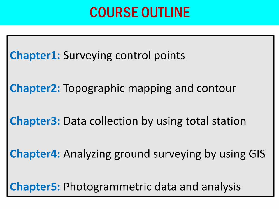
Chapter1: Surveying control points
Chapter2: Topographic mapping and contour
Chapter3: Data collection by using total station
Chapter4: Analyzing ground surveying by using GIS
Chapter5: Photogrammetric data and analysis
COURSE OUTLINE

CHAPTER ONE
SURVEYING CONTROL POINTS
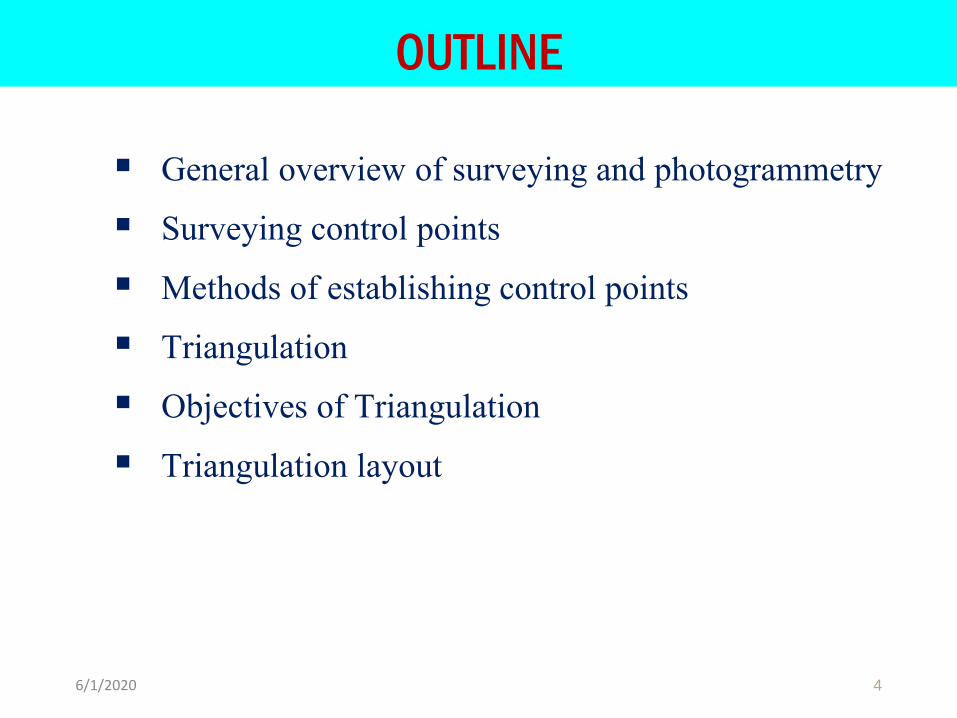
OUTLINE
▪ General overview of surveying and photogrammetry
▪ Surveying control points
▪ Methods of establishing control points
▪ Triangulation
▪ Objectives of Triangulation
▪ Triangulation layout
46/1/2020
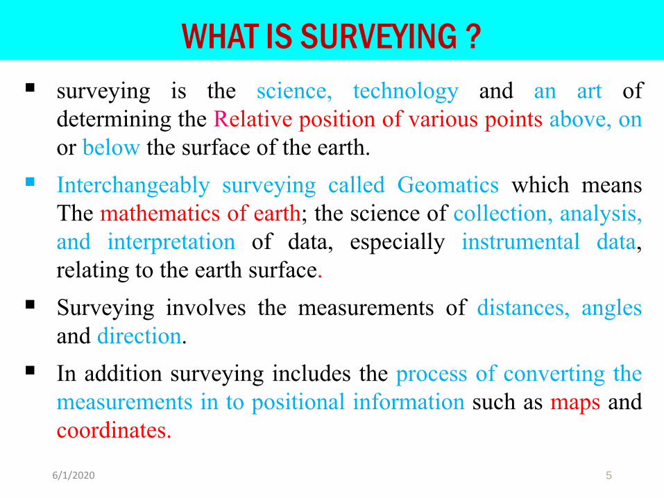
WHAT IS SURVEYING ?
▪ surveying is the science, technology and an art ofdetermining the Relative position of various points above, onor below the surface of the earth.
▪ Interchangeably surveying called Geomatics which meansThe mathematics of earth; the science of collection, analysis,and interpretation of data, especially instrumental data,relating to the earth surface.
▪ Surveying involves the measurements of distances, anglesand direction.
▪ In addition surveying includes the process of converting themeasurements in to positional information such as maps andcoordinates.
56/1/2020
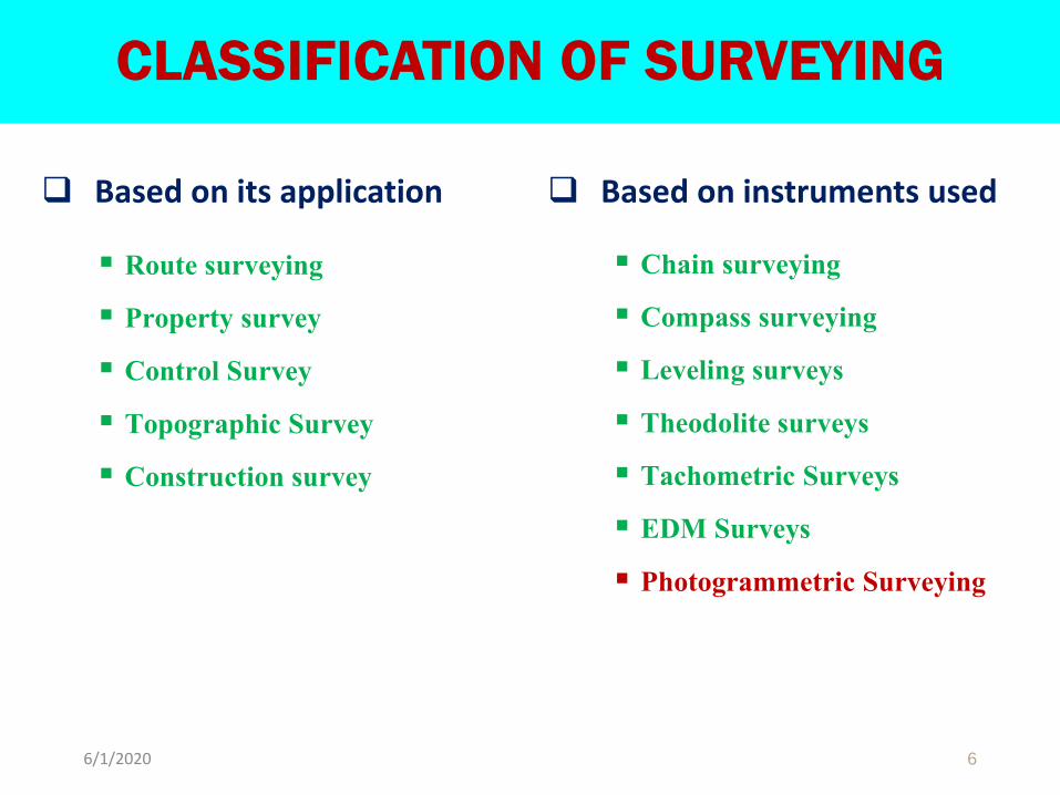
CLASSIFICATION OF SURVEYING
❑ Based on its application
▪ Route surveying
▪ Property survey
▪ Control Survey
▪ Topographic Survey
▪ Construction survey
❑ Based on instruments used
▪ Chain surveying
▪ Compass surveying
▪ Leveling surveys
▪ Theodolite surveys
▪ Tachometric Surveys
▪ EDM Surveys
▪ Photogrammetric Surveying
6/1/2020 6
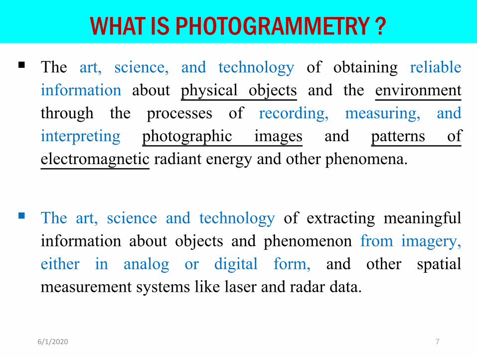
WHAT IS PHOTOGRAMMETRY ?
▪ The art, science, and technology of obtaining reliableinformation about physical objects and the environmentthrough the processes of recording, measuring, andinterpreting photographic images and patterns ofelectromagnetic radiant energy and other phenomena.
▪ The art, science and technology of extracting meaningfulinformation about objects and phenomenon from imagery,either in analog or digital form, and other spatialmeasurement systems like laser and radar data.
76/1/2020
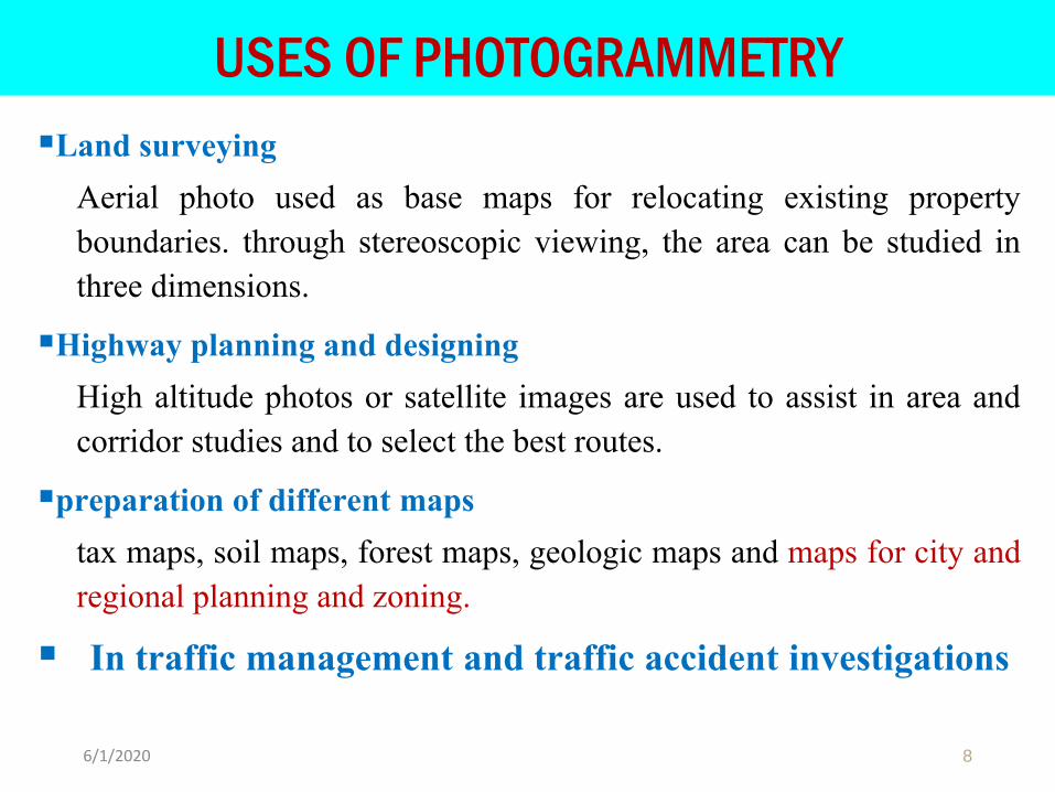
USES OF PHOTOGRAMMETRY
▪Land surveying
Aerial photo used as base maps for relocating existing propertyboundaries. through stereoscopic viewing, the area can be studied inthree dimensions.
▪Highway planning and designing
High altitude photos or satellite images are used to assist in area andcorridor studies and to select the best routes.
▪preparation of different maps
tax maps, soil maps, forest maps, geologic maps and maps for city andregional planning and zoning.
▪ In traffic management and traffic accident investigations
86/1/2020
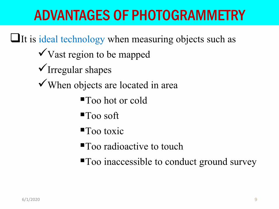
ADVANTAGES OF PHOTOGRAMMETRY
❑It is ideal technology when measuring objects such as
✓Vast region to be mapped
✓Irregular shapes
✓When objects are located in area
▪Too hot or cold
▪Too soft
▪Too toxic
▪Too radioactive to touch
▪Too inaccessible to conduct ground survey
96/1/2020

CONT…
❑High speed of map generation
❑Very precise
❑Time effective
❑Cost effective
❑Based on well established and tested and algorithm
❑Less manual effort
❑Extraction of geometrical and qualitative information
❑Cheaper than terrestrial methods
106/1/2020
CONTROL POINT
▪ Geographic positions are specified relative to a fixed reference.
▪ Positions on the globe, for instance, may be specified in terms ofangles relative to the center of the Earth, the equator, and theprime meridian.
▪ Positions in plane coordinate grids are specified as distances fromthe origin of the coordinate system.
▪ Elevations are expressed as distances above or below a verticaldatum such as mean sea level, or an ellipsoid such as GRS 80,WGS 84, clarck1880.
▪ Land surveyors measure horizontal positions in geographic orplane coordinate systems relative to previously surveyed positionscalled control points.
116/1/2020
CONT…
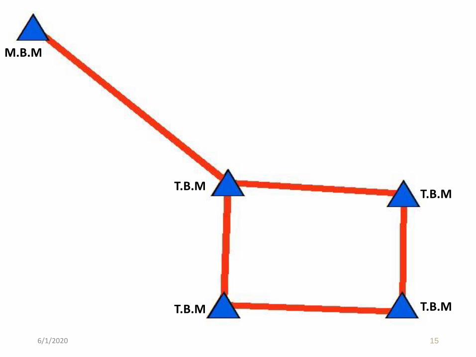
▪ A control point is a point on the ground or any permanentstructure whose horizontal and vertical location/position isknown.
▪ Control points are used as a starting point of all types ofsurveys.
▪ The 3D coordinates (X, Y, Z) of each point to be surveyed canonly be determined with respect to well established referencepoints.
▪ It provides the basis for positioning structures in each of thestages of planning, design and construction.
▪ To set out structures in all 3D in a correct relative position anumber of control stations are established in project area.
126/1/2020
TYPES OF CONTROL POINTS
❑ Horizontal control▪ Is provided by two or more points on the ground and precisely fixed in
position by distance and direction.
▪ is usually established by a traverse.
▪ The HD to salient points of the structure can be measured fromhorizonal controls.
▪ Increasing the number of control station will increase the accuracy ofthe measurement.
136/1/2020
❑Vertical control▪ provided by establishing the reference bench marks of known elevation
relative to some specific datum.
▪ The levels of various points on the structure are determined from theseBM.
▪ BM may be master bench mark (M.B.M) and temporary bench mark(T.B.M)
▪M.B.M is established in project area by running leveling from nearbybench mark.
146/1/2020
CONT…
156/1/2020
M.B.M
T.B.M
T.B.MT.B.M
T.B.M
THE CONTROL POINTS MUST BE
1) Convenient for use, that is, located sufficiently close to theitem being built so that work is minimized and accuracyenhanced in transferring alignment and grade.
2) Far enough from the actual construction to ensure workingroom for the contractor and to avoid possible destruction ofstakes.
3) Clearly marked and understood by the contractor in theabsence of a surveyor.
166/1/2020
CONT…
4) Supplemented by guard stakes to deter removal andreferenced to facilitate restoring them. Contracts usuallyrequire the owner to pay the cost of setting initial controlpoints and the contractor to replace damaged or removedones.
5) Suitable for securing the accuracy agreed on for constructionlayout.
176/1/2020
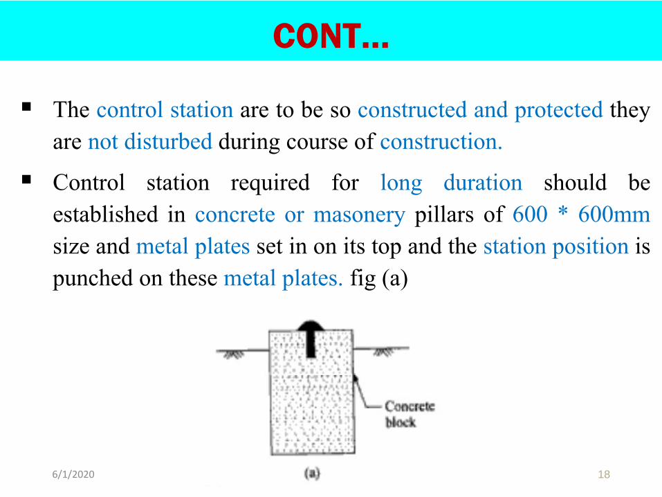
▪ The control station are to be so constructed and protected theyare not disturbed during course of construction.
▪ Control station required for long duration should beestablished in concrete or masonery pillars of 600 * 600mmsize and metal plates set in on its top and the station position ispunched on these metal plates. fig (a)
186/1/2020
CONT…
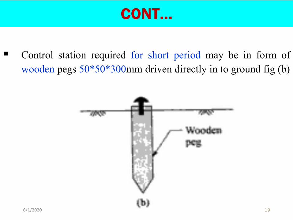
▪ Control station required for short period may be in form ofwooden pegs 50*50*300mm driven directly in to ground fig (b)
6/1/2020 19
CONT…
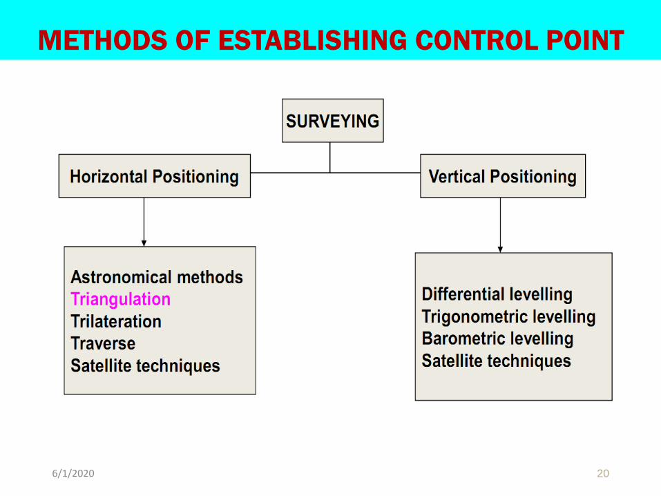
METHODS OF ESTABLISHING CONTROL POINT
206/1/2020
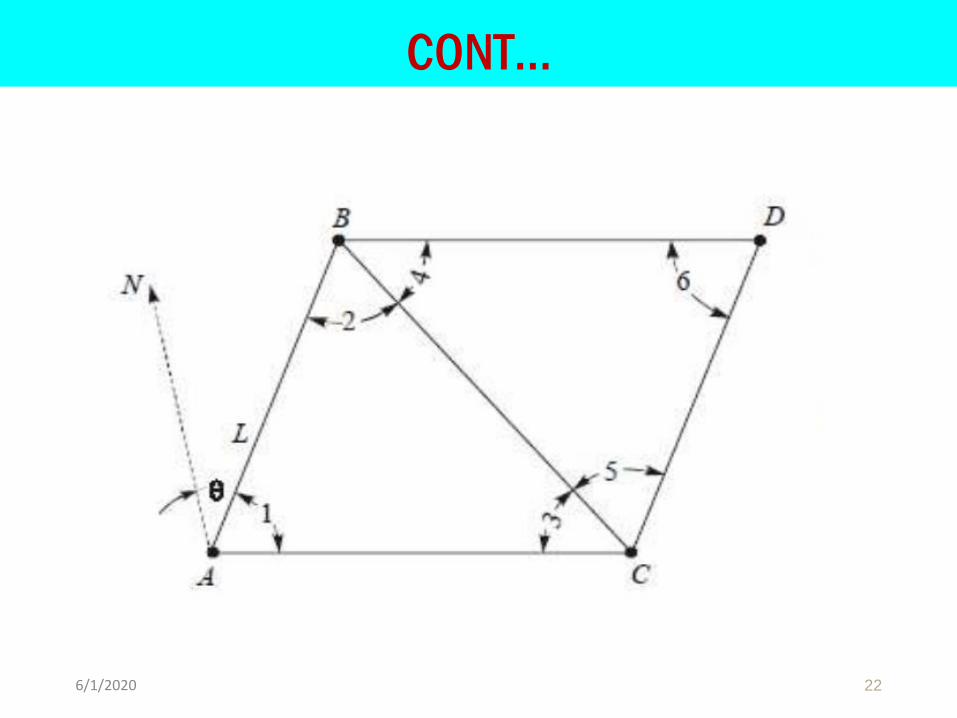
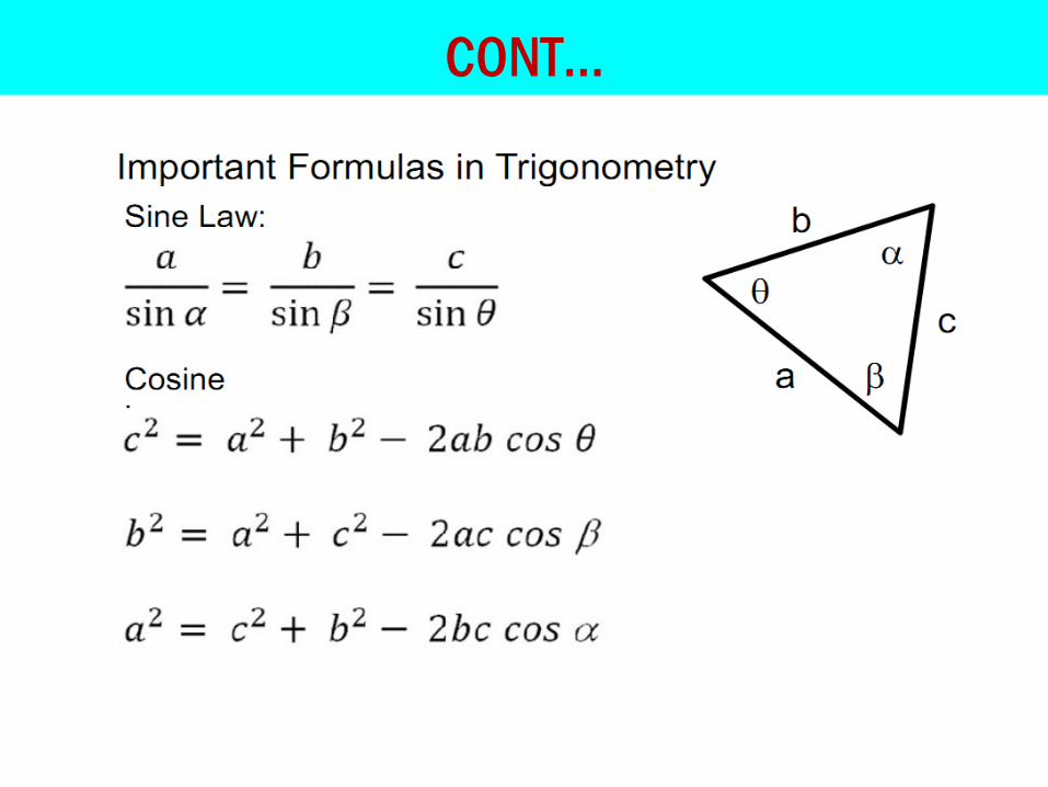
TRIANGULATION
▪ Utilizes geometric figures composed of triangles
▪ Method of determining distance based on the principles ofgeometry.
▪ Horizontal angles and Length of base lines are measured byusing surveying instrument.
▪ By using angles and base line lengths, triangles are solvedtrigonometrically and the positions of stations (vertices) arecalculated.
216/1/2020
CONT…
226/1/2020
CONT…
236/1/2020
OBJECTIVE OF TRIANGULATION
▪ To establish accurate control for plane and geodetic surveysof large areas
▪ To establish accurate control points for photogrammetricsurveys of large areas.
▪ To determine accurate locations of points in engineeringworks
▪ To assist in the determination of the size and shape of theearth by making observations for latitude, longitude andgravity
246/1/2020
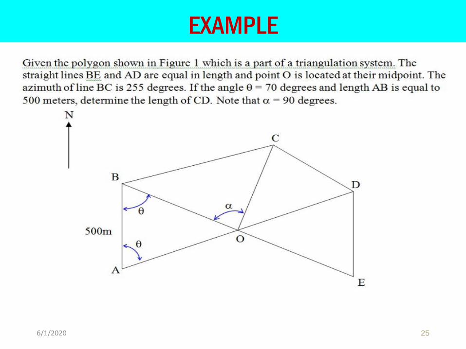
EXAMPLE
256/1/2020
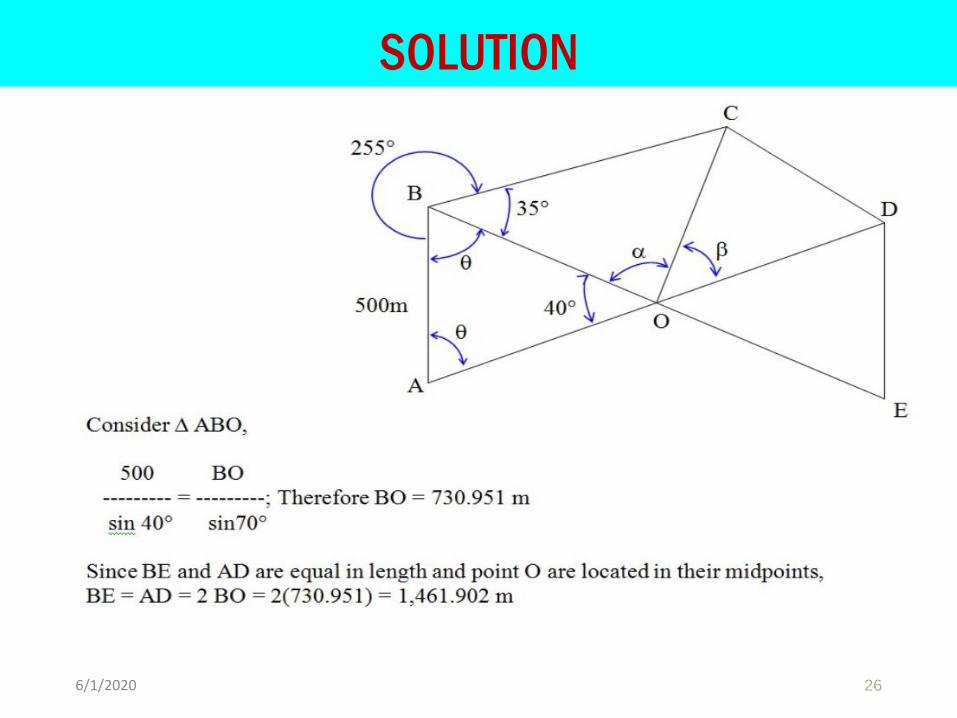
SOLUTION
266/1/2020
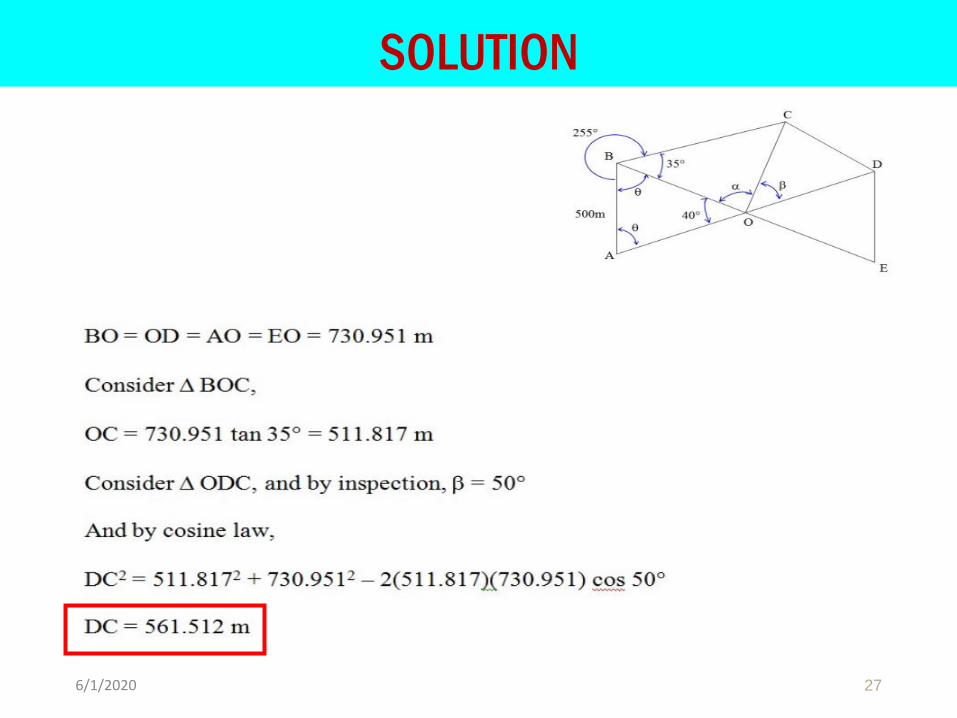
SOLUTION
276/1/2020
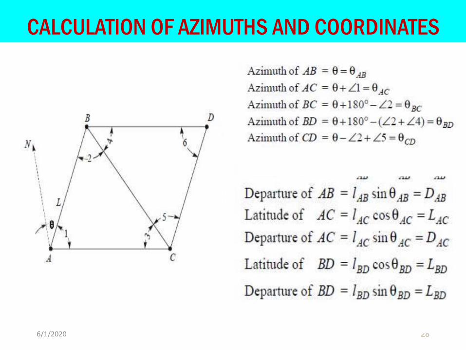
CALCULATION OF AZIMUTHS AND COORDINATES
286/1/2020
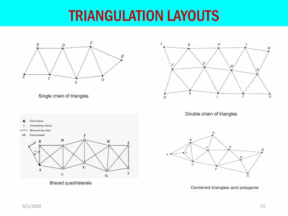
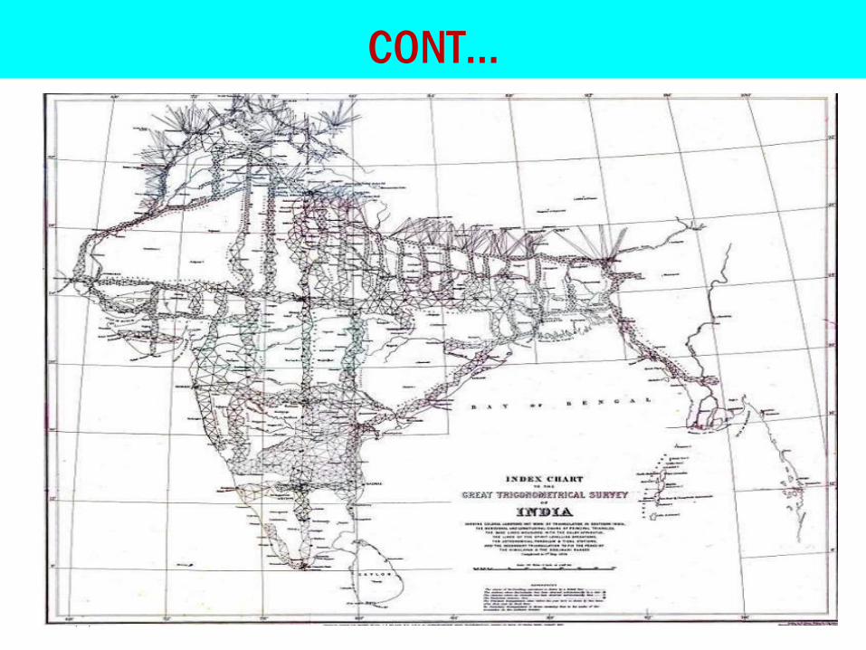
TRIANGULATION LAYOUTS
296/1/2020
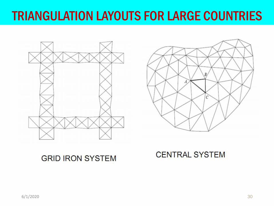
TRIANGULATION LAYOUTS FOR LARGE COUNTRIES
306/1/2020
CONT…
316/1/2020

DNE
CHAPTER TWO
Topographic Mapping and Contour
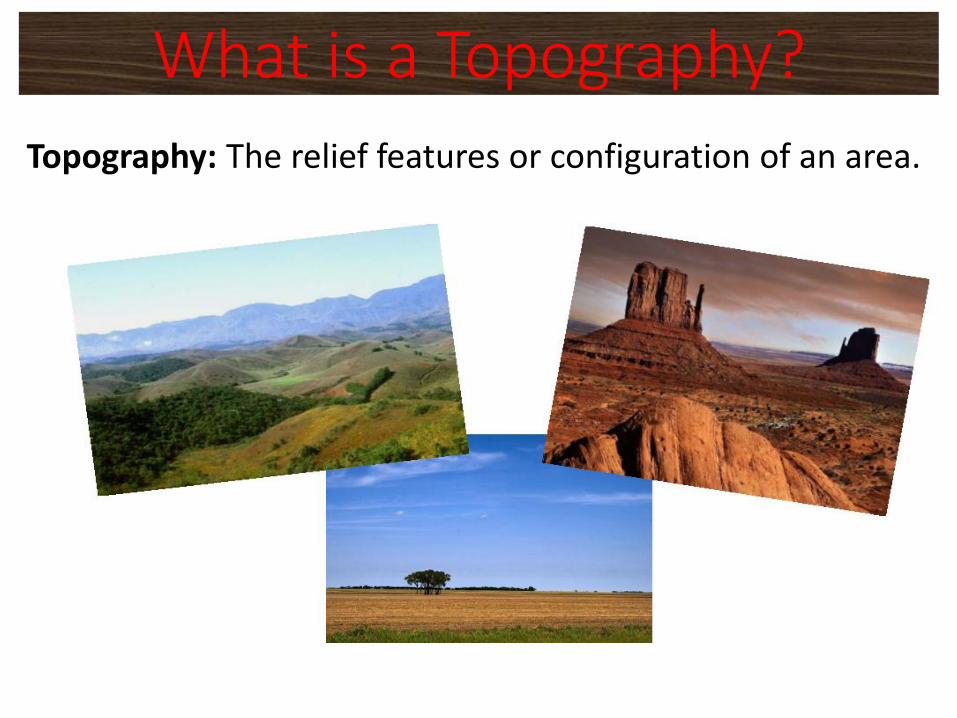
Topography: The relief features or configuration of an area.
What is a Topography?
❖A topographic map is a detailed and accurate illustrationof man-made and natural features on the ground such asroads, railways, power transmission lines, contours,elevations, rivers, lakes and geographical names.
❖The topographic map is a two-dimensionalrepresentation of the Earth’s three-dimensionallandscape.
Topographic map
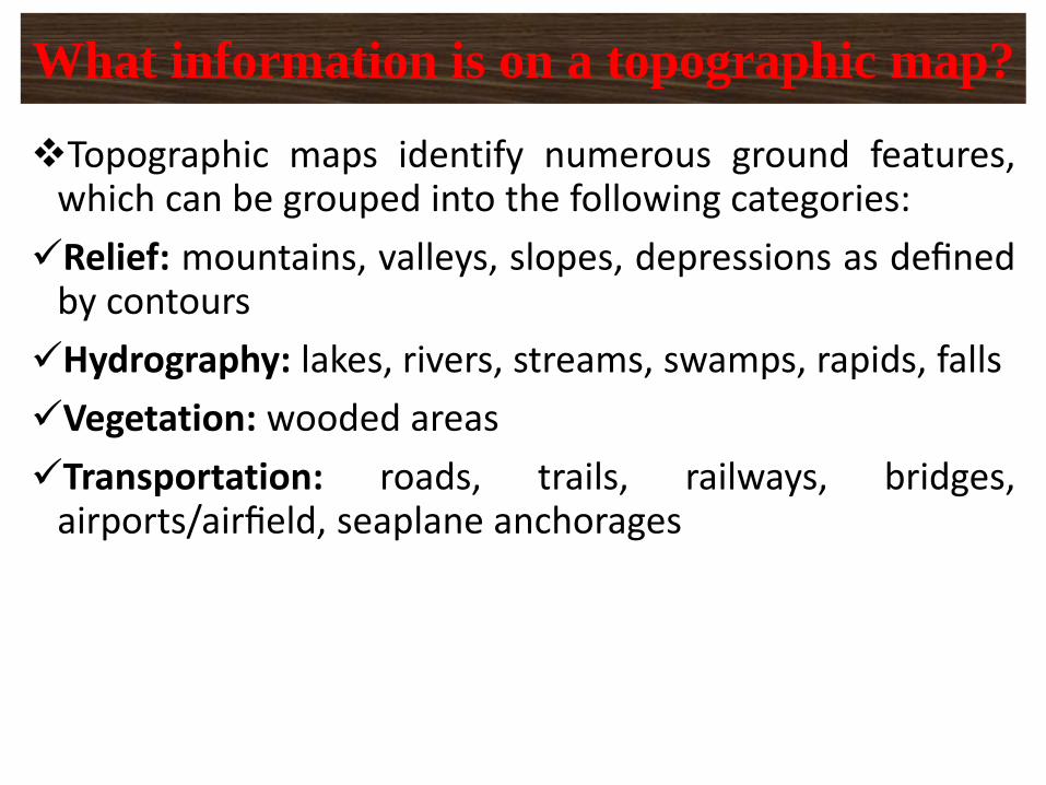
❖Topographic maps identify numerous ground features,which can be grouped into the following categories:
✓Relief: mountains, valleys, slopes, depressions as definedby contours
✓Hydrography: lakes, rivers, streams, swamps, rapids, falls
✓Vegetation: wooded areas
✓Transportation: roads, trails, railways, bridges,airports/airfield, seaplane anchorages
What information is on a topographic map?
✓Culture: buildings, urban development, powertransmission line, pipelines, towers
✓Boundaries: international, provincial/territorial,administrative, recreational, geographical
✓Toponymy: place names, water feature names, landformnames, boundary names
CONT…
❖Both types of maps show roads, water features, citiesand parks, but that’s where the similarity ends.
❖Topographic maps show contours, elevation, forest cover,marsh, pipelines, power transmission lines, buildings andvarious types of boundary lines such as international,provincial and administrative, and many others.
Is a topographic map similar to a road map?
❖Topographic maps show a universal transverse mercator(UTM) grid, allowing the user to determine precisepositions. In basic terms, topographic maps allow theuser to see a three-dimensional landscape on a two-dimensional surface.
CONT…
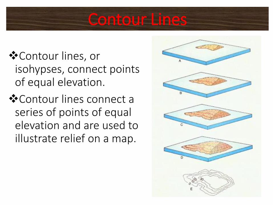
❖Contour lines, or isohypses, connect points of equal elevation.
❖Contour lines connect a series of points of equal elevation and are used to illustrate relief on a map.
Contour Lines
❖They show the height of ground above mean sea level(MSL) either in metres or feet, and can be drawn at anydesired interval.❖For example, numerous contour lines that are close toone another indicate hilly or mountainous terrain; whenfurther apart they indicate a gentler slope; and when farapart they indicate flat terrain.
CONT…
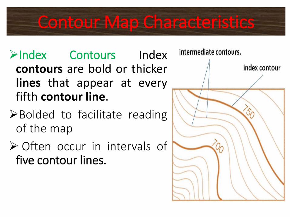
➢Index Contours Indexcontours are bold or thickerlines that appear at everyfifth contour line.
➢Bolded to facilitate readingof the map
➢ Often occur in intervals offive contour lines.
Contour Map Characteristics
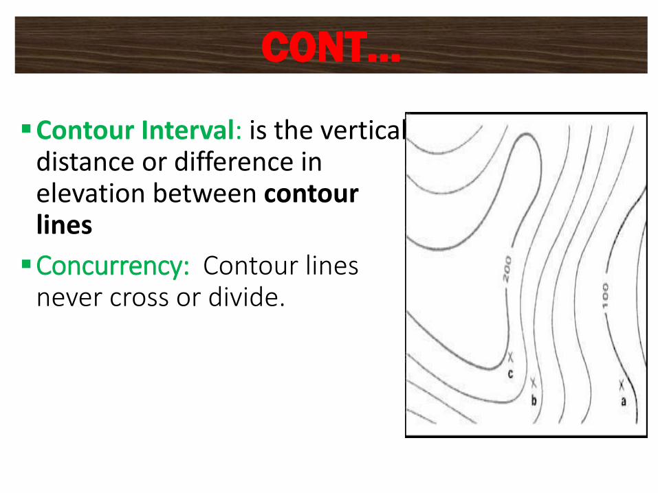
▪Contour Interval: is the vertical distance or difference in elevation between contour lines
▪Concurrency: Contour lines never cross or divide.
CONT…
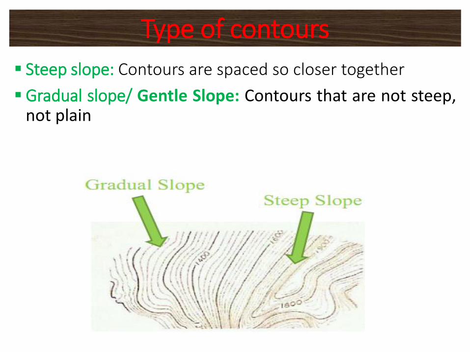
▪ Steep slope: Contours are spaced so closer together
▪Gradual slope/ Gentle Slope: Contours that are not steep,not plain
Type of contours
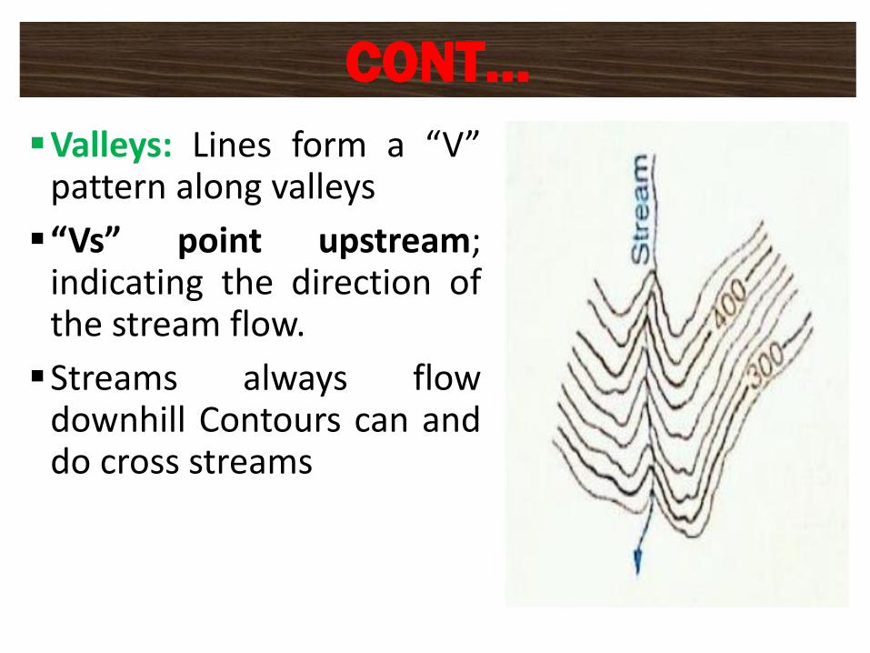
▪Valleys: Lines form a “V”pattern along valleys
▪“Vs” point upstream;indicating the direction ofthe stream flow.
▪Streams always flowdownhill Contours can anddo cross streams
CONT…
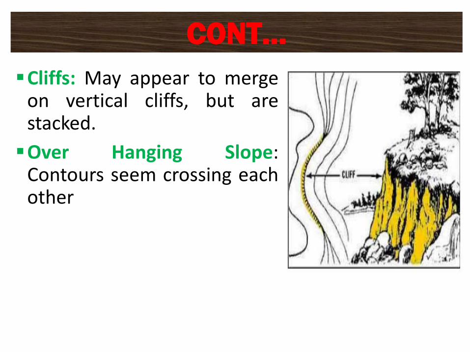
▪Cliffs: May appear to mergeon vertical cliffs, but arestacked.
▪Over Hanging Slope:Contours seem crossing eachother
CONT…
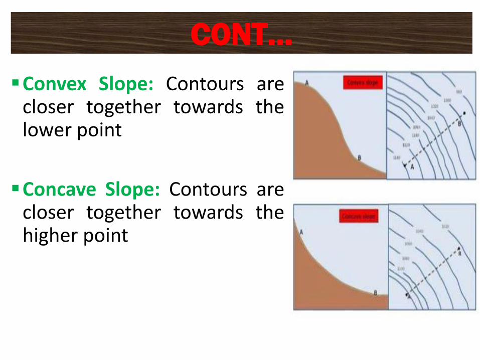
▪Convex Slope: Contours arecloser together towards thelower point
▪Concave Slope: Contours arecloser together towards thehigher point
CONT…
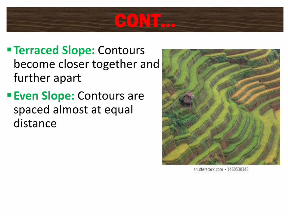
▪Terraced Slope: Contours become closer together and further apart
▪Even Slope: Contours are spaced almost at equal distance
CONT…
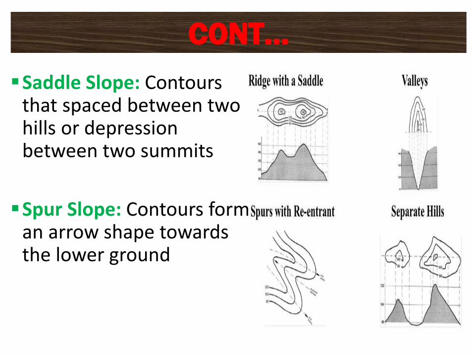
▪Saddle Slope: Contours that spaced between two hills or depression between two summits
▪Spur Slope: Contours form an arrow shape towards the lower ground
CONT…
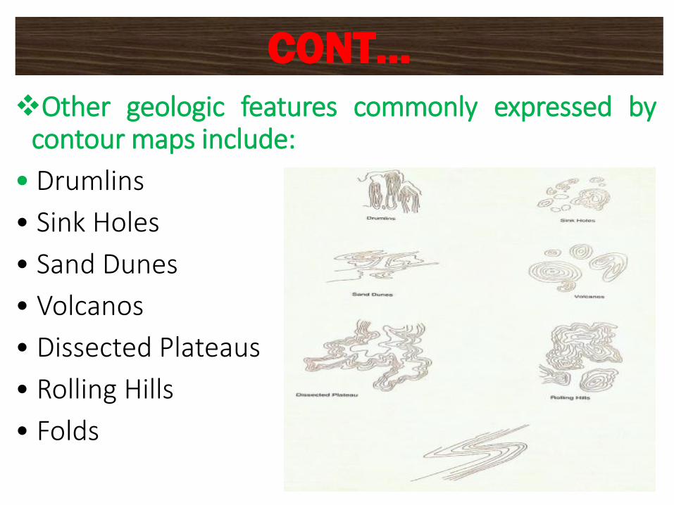
❖Other geologic features commonly expressed bycontour maps include:
• Drumlins
• Sink Holes
• Sand Dunes
• Volcanos
• Dissected Plateaus
• Rolling Hills
• Folds
CONT…

DNE
CHAPTER THREE
DATA COLLECTION BY USING TOTAL STATION
❑What is data?
▪Data are characteristics or information, usually numerical,that are collected through observation.
▪ In a more technical sense, data is a set of valuesof qualitative or quantitative variables about one or morepersons or objects.
▪ Although the terms "data" and "information" are oftenused interchangeably, these terms have distinctmeanings.
▪ In some popular publications, data is sometimes said tobe transformed into information when it is viewed incontext or in post-analysis.
53
INTRODUCTION
▪ In academic treatments of the subject, however, data aresimply units of information.
▪ Data is measured, collected and reported, and analyzed,whereupon it can be visualized using graphs, images orother analysis tools.
▪ Data as a general concept refers to the fact that someexisting information or knowledge is represented or codedin some form suitable for better usage or processing.
▪ Raw data ("unprocessed data") is a collectionof numbers or characters before it has been "cleaned"and corrected by researchers or surveyor.
54
CONT…
❑Data collection is the process of gathering andmeasuring information on targeted variables in anestablished system, which then enables one to answerrelevant questions and evaluate outcomes.
❑Data collection is a component of research in all fields ofstudy including physical and social sciences,humanities, and business.
❑While methods vary by discipline, the emphasis onensuring accurate and honest collection remains thesame.
55
CONT…
❑The goal for all data collection is to capture qualityevidence that allows analysis to lead to the formulation ofconvincing and credible answers to the questions thathave been posed.
❑Regardless of the field of study or preference for definingdata (quantitative or qualitative), accurate data collectionis essential to maintaining the integrity of research.
❑The selection of appropriate data collection instruments(existing, modified, or newly developed) and clearlydelineated instructions for their correct use reduce thelikelihood of errors.
56
CONT…
▪Gathering data can be accomplished through a primarysource or a secondary source.
▪ primary source: the researcher is the first person toobtain the data.
▪ secondary source: the researcher obtains the data thathas already been collected by other sources, such as datadisseminated in a scientific journal.
57
CONT…
▪ In surveying there are many methods used for datacollection, but we select the best method based on theneed, type, location and accuracy of data.
▪ For example, we can use one of the following
✓Theodolite survey
✓Photogrammetric survey
✓Total station survey
▪ In this chapter we will se data collection by total station.
58
Data Collection Methods
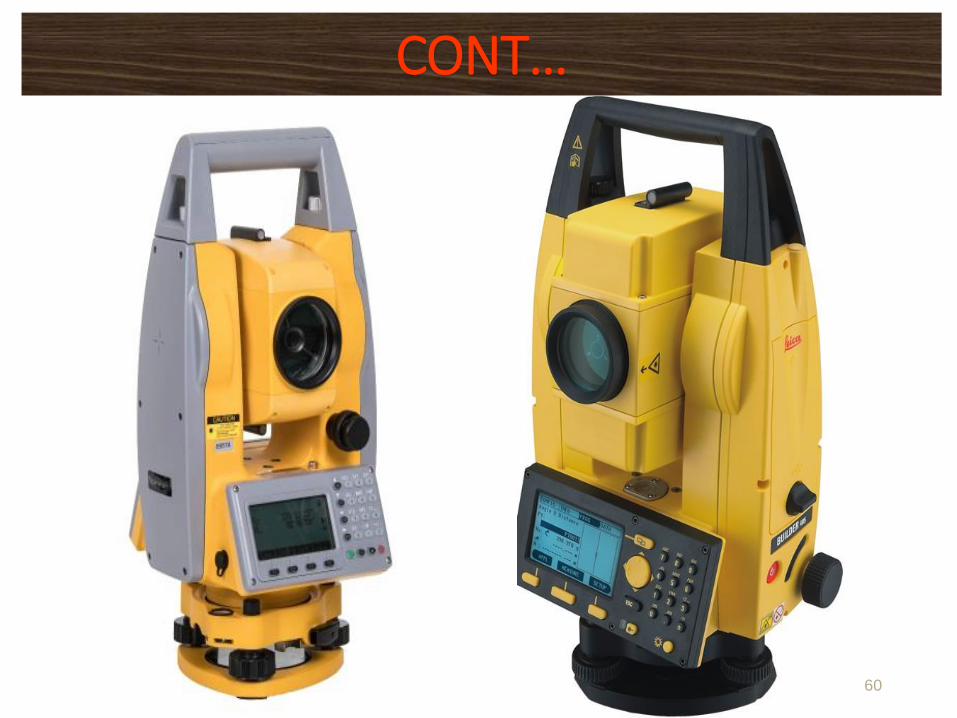
❑What is a Total Station?
• Total station is a surveying equipment combinationof Electromagnetic Distance Measuring Instrument andelectronic theodolite.
• It is also integrated with microprocessor, electronic datacollector and storage system.
• It is an electronic transit theodolite integrated withelectronic distance measurement (EDM) to measure bothvertical and horizontal angles and the slope distance fromthe instrument to a particular point, and an on-boardcomputer to collect data and perform triangulationcalculations.
59
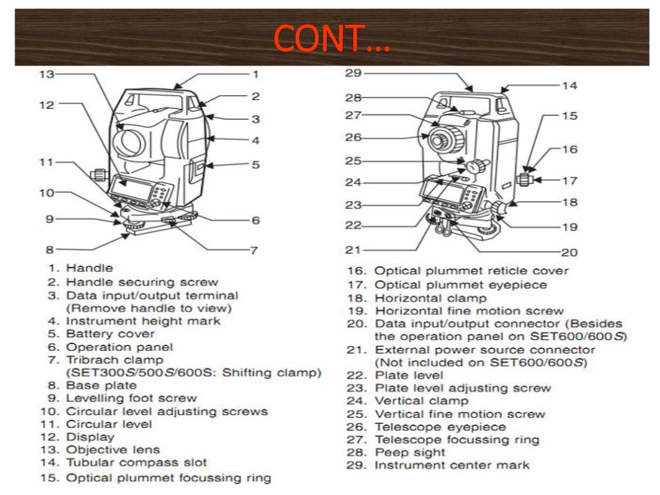
Total station
60
CONT…
61
CONT…
• Angle measurement: Most total station instrumentsmeasure angles by means of electro-optical scanning ofextremely precise digital bar-codes etched on rotatingglass cylinders or discs within the instrument.
• Distance measurement: this is accomplished with amodulated infrared carrier signal, generated by a smallsolid-state emitter within the instrument's optical path,and reflected by a prism reflector or the object undersurvey.
62
Function of total station
• Coordinate measurement: the coordinates of anunknown point relative to a known coordinate can bedetermined using the total station as long as a direct lineof sight can be established between the two points.Angles and distances are measured from the total stationto points under survey, and the coordinates (X, Y, and Z)of surveyed points relative to the total station positionare calculated using trigonometry and triangulation.
63
CONT…
• Data processing: Some models include internal electronicdata storage to record distance, horizontal angle, andvertical angle measured, while other models areequipped to write these measurements to an externaldata collector, such as a hand-held computer. When datais downloaded from a total station onto a computer,application software can be used to compute results andgenerate a map of the surveyed area.
64
CONT…
• Display: Electronic display unit is capable of displayingvarious values when respective keys are pressed. Thesystem is capable of displaying horizontal distance,vertical distance, horizontal and vertical angles, differencein elevations of two observed points and all the threecoordinates of the observed points.
• Electronic Book: Each point data can be stored in anelectronic note book (like compact disc). The capacity ofelectronic note book varies from 2000 points to 4000points data. Surveyor can unload the data stored in notebook to computer and reuse the note book.
65
CONT…
▪Microprocessor unit in total station processes the data collected to compute:
• Average of multiple angles measured.
• Average of multiple distance measured.
• Horizontal distance.
• Distance between any two points.
• Elevation of objects and
• All the three coordinates of the observed points.
66
Capability of a Total Station
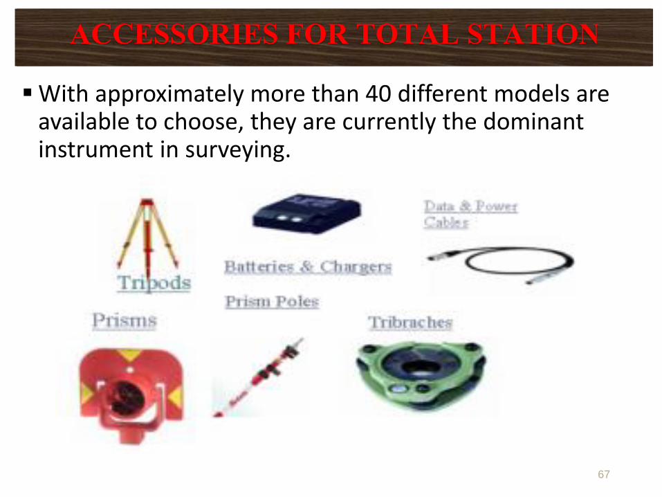
▪With approximately more than 40 different models are available to choose, they are currently the dominant instrument in surveying.
67
ACCESSORIES FOR TOTAL STATION
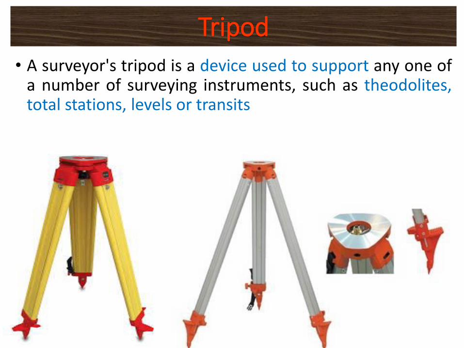
• A surveyor's tripod is a device used to support any one ofa number of surveying instruments, such as theodolites,total stations, levels or transits
68
Tripod
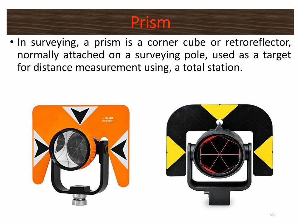
• In surveying, a prism is a corner cube or retroreflector,normally attached on a surveying pole, used as a targetfor distance measurement using, a total station.
69
Prism
• The EDM instrument component installed in a TotalStation is relatively small but still has distance rangesadequate for most work.
• Lengths up to about 2 km can be measured with a singleprism, and up to about 6 to 7 km with triple prism.
• The angle resolution of available Total Stations variesfrom as low as a half-second for precise instrumentssuitable for control surveys, up to 20″ for instrumentsmade specifically for construction stakeout.
70
CONT…
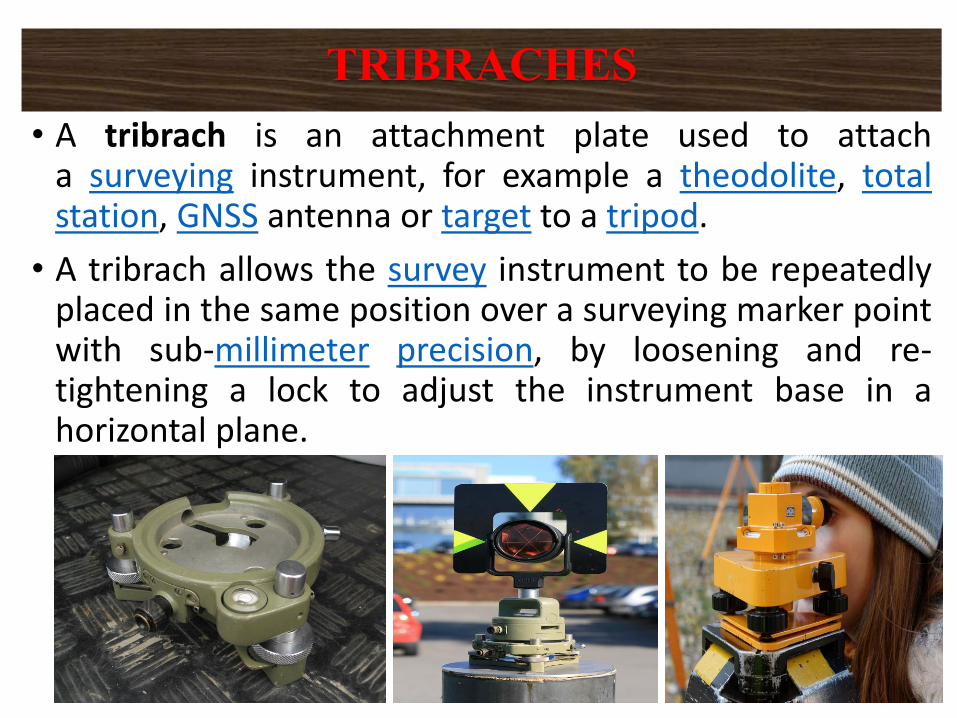
• A tribrach is an attachment plate used to attacha surveying instrument, for example a theodolite, totalstation, GNSS antenna or target to a tripod.
• A tribrach allows the survey instrument to be repeatedlyplaced in the same position over a surveying marker pointwith sub-millimeter precision, by loosening and re-tightening a lock to adjust the instrument base in ahorizontal plane.
71
TRIBRACHES
▪ Because the Total Station contains delicate electroniccomponents they are not as rugged as ordinaryTheodolite.
▪ They must be packed and transported carefully, handledgently and carefully removed form their cases.
▪ The setting of Total Station over the station mark issimilar to an ordinary Theodolite. This includes
✓Centering
✓Levelling
✓Removal of parallax
72
OPERATION OF TOTAL STATION
▪ Total Stations are controlled with entries made eitherthrough their built-in keyboards or through the keyboardsof hand-held data collectors.
▪ Details for operating each individual total station varysomewhat and therefore are not described here.
▪ The accuracy achieved with total station is mainlydepends on operator procedure of
✓Careful centering and levelling of the instrument
✓Accurate pointing at targets.
✓Taking averages of multiple angle measurementsmade in both direct and reverse positions
73
CONT…
▪ In general the Total Station step-by-step procedure formeasuring coordinate data goes as follows:
1. Level the instrument2. Power up and initialize the instrument3. Select and make active the proper job name (i.e. “G1" for
Group 1, etc.)4. Enter any XYZ data given to you (benchmarks, etc.) as “known
data”.5. In the “[MEAS]” menu select “[COORD]” to define the station
position, select a back sight, and test the calibration of theinstrument. After this step you will be ready to collect data.
6. To successfully complete this step you MUST have theinstrument leveled on a known coordinate point, and thetarget must be setup on another known point.
7. Continue to use [COORD] to collect data at target points inthe mapping area
74
Data Collection by total station
▪Measurements can be stored “on board” with all the totalstations.
❑The two options that are available are
▪ Data can be stored directly in the memory of themicrocomputer, and later downloaded to an externalstorage device via connections or cables.
▪ The second option is the removable memory card. Whenone card is full, it can be removed and another card canbe quickly installed.
75
Data Collection Option in total station
▪ The following are some of the major advantages of using totalstation over the conventional surveying instruments:
• Field work is carried out very fast.
• Accuracy of measurement is high.
• Manual errors involved in reading and recording are eliminated.
• Calculation of coordinates is very fast and accurate. Evencorrections for temperature and pressure are automaticallymade.
• Computers can be employed for map making and plottingcontour and cross-sections.
▪ However, surveyor should check the working condition of theinstruments before using. For this standard points may be locatednear survey office and before taking out instrument for field work,its working is checked by observing those standard points from thespecified instrument station.
76
Advantages of Using Total Stations
DNE
CHAPTER FOUR
ANALYZING GROUND SURVEYING BY USING GIS
CHAPTER FIVE
PHOTOGRAMMETRIC DATA AND ANALYSIS
▪ As you understand from the topic, those chapters focuson practical of analyzing ground data by using GIS andanalyzing photogrammetric data. Thus, we will see it inlab when you come back to regular class.

Prevent covid-19
▪Stay @ home
▪Keep your distance
▪Use hand sanitizer and face mask
▪Wash your hands with clean water and sop

IF YOU HAVE ANY QUESTION YOU CAN CONTACT ME VIA MY EMAIL
THANK YOU FOR FOLLOWING

DNE