amendment to suats long range transportation plansumtersc.gov/data/sites/1/media/departments/... ·...
TRANSCRIPT
AmendmenttoSUATSLongRangeTransportationPlan,2010-2040
October,2016
TheCompleteStreetconceptwasdiscussedonChapterFive(page5-16)oftheSUATSLongRangeTransportationPlan(LRTP),2010-2040.TheSUATSLRTP,2010-2040wasapprovedbytheSUATSPolicyCommitteeonApril26,2013.However,noroadwayswereidentifiedfortheimplementationatthattime.TwosegmentscomprisingtheManningAvenue/NorthMainStRevitalizationProjectareaddedinto:
Figure5.2(RecommendedRoadwayProjects)
ProjectAAA: NorthMainStreetCorridor,termini:CalhountoLafayetteDrive
ProjectBBB: ManningAvenueCorridor,termini:EndofManningAveBridgetoSHarvinStreet
ProjectSheets
InserttoPage5-44
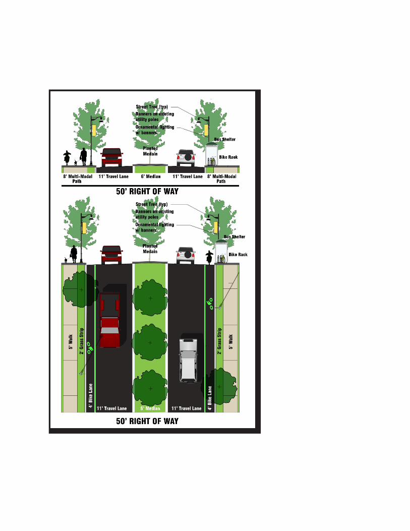
ProjectAAA-NorthMainStreetCorridor CompleteStreetTermini:CalhounStreettoLafayetteDriveNMainStreet(ProjectAAA)isproposedtoconstructmultimodalpaths,grassorplantedverge,bikelanes,travellanes,medianwithplantation,busstopwithshelter,ornamentallightpolesandundergroundutilitieswherefeasiblefromCalhounStreettoLafayetteDrive.Withimprovements,thiscorridorprovidesmultimodalaccessandsafetyenvironmentforpedestrians,drivers,cyclistsandtransitriders.ThiscorridorprovidesadirectconnectionfromdowntownSumtertoseveralmajoremploymentcenters,suchasPalmettoTuomeyHospital,postaloffice,CityandCountygovernmentoffices,CrosswellElementaryschool,restaurants,retailstoresandMorrisCollege.Also,theimprovementswillprovideasafeconnectivitytoHighwayUS76/378intheNorthandOswegoHighway(US401)intheSouth.Theintersectionsimprovementalsowillreducethenumberofcrashes.
Thediagramonthenextpageisforillustrationonly(notinscale)oftheCompleteStreetconceptthatspacesaredesignatedforpedestrians,bicyclists,drivers,transitridersandgreenvegetation.
ThelocationofthisprojectisshownonProjectAAA–vicinitymap.
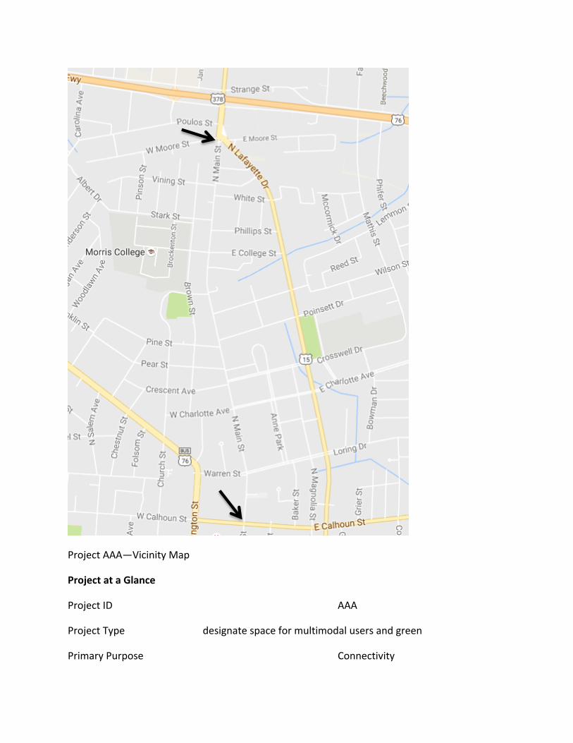
ProjectAAA—VicinityMap
ProjectataGlance
ProjectID AAA
ProjectType designatespaceformultimodalusersandgreen
PrimaryPurpose Connectivity
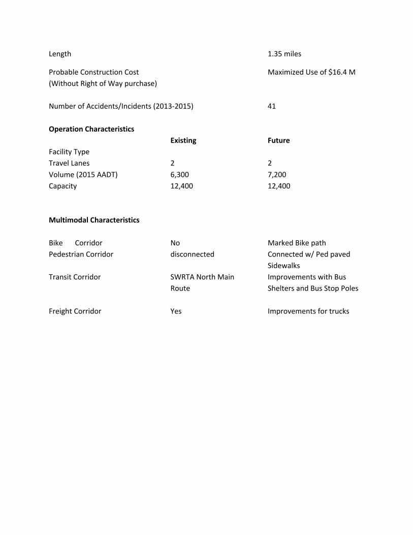
Length 1.35miles
ProbableConstructionCost MaximizedUseof$16.4M(WithoutRightofWaypurchase)NumberofAccidents/Incidents(2013-2015) 41OperationCharacteristics Existing FutureFacilityType TravelLanes 2 2Volume(2015AADT) 6,300 7,200Capacity 12,400 12,400 MultimodalCharacteristicsBike Corridor No MarkedBikepathPedestrianCorridor disconnected Connectedw/Pedpaved SidewalksTransitCorridor SWRTANorthMain ImprovementswithBus Route SheltersandBusStopPolesFreightCorridor Yes Improvementsfortrucks
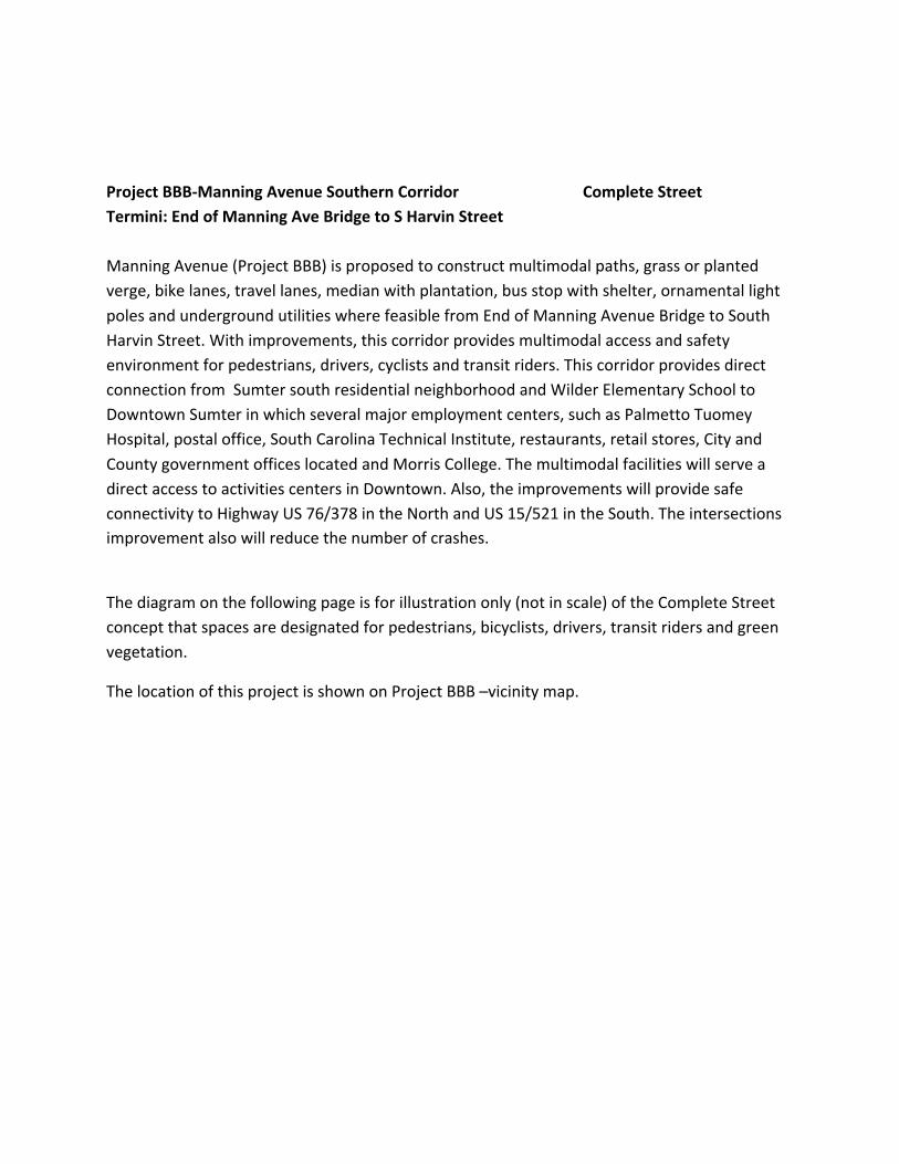
ProjectBBB-ManningAvenueSouthernCorridor CompleteStreetTermini:EndofManningAveBridgetoSHarvinStreetManningAvenue(ProjectBBB)isproposedtoconstructmultimodalpaths,grassorplantedverge,bikelanes,travellanes,medianwithplantation,busstopwithshelter,ornamentallightpolesandundergroundutilitieswherefeasiblefromEndofManningAvenueBridgetoSouthHarvinStreet.Withimprovements,thiscorridorprovidesmultimodalaccessandsafetyenvironmentforpedestrians,drivers,cyclistsandtransitriders.ThiscorridorprovidesdirectconnectionfromSumtersouthresidentialneighborhoodandWilderElementarySchooltoDowntownSumterinwhichseveralmajoremploymentcenters,suchasPalmettoTuomeyHospital,postaloffice,SouthCarolinaTechnicalInstitute,restaurants,retailstores,CityandCountygovernmentofficeslocatedandMorrisCollege.ThemultimodalfacilitieswillserveadirectaccesstoactivitiescentersinDowntown.Also,theimprovementswillprovidesafeconnectivitytoHighwayUS76/378intheNorthandUS15/521intheSouth.Theintersectionsimprovementalsowillreducethenumberofcrashes.
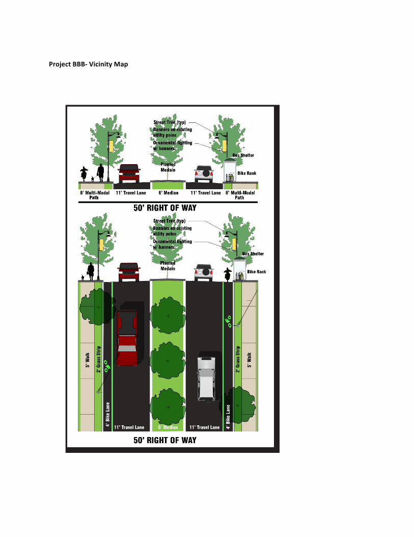
Thediagramonthefollowingpageisforillustrationonly(notinscale)oftheCompleteStreetconceptthatspacesaredesignatedforpedestrians,bicyclists,drivers,transitridersandgreenvegetation.
ThelocationofthisprojectisshownonProjectBBB–vicinitymap.
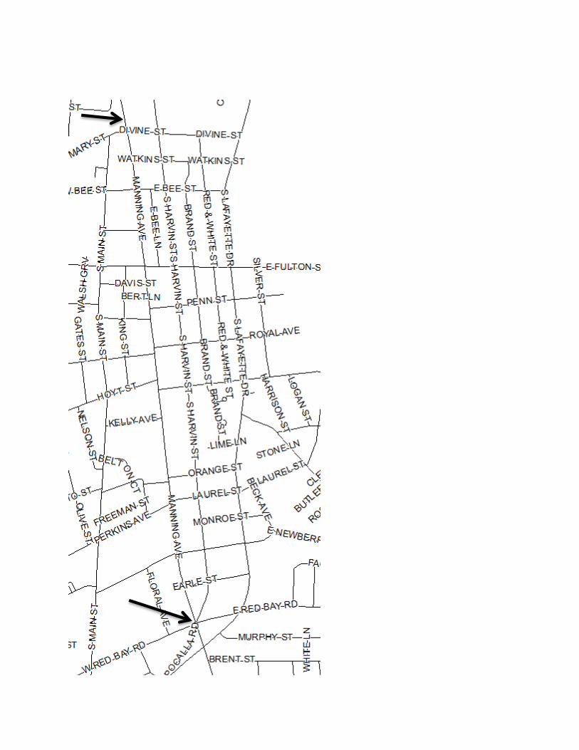
ProjectBBB-VicinityMap
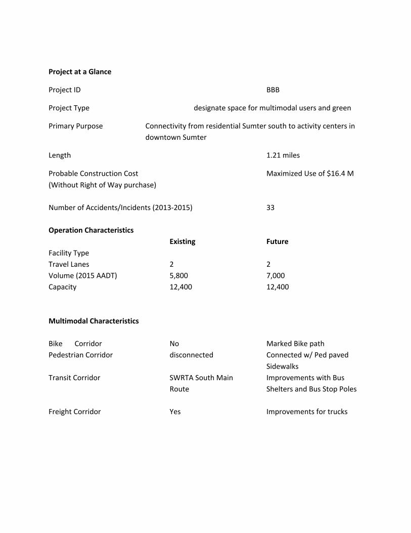
ProjectataGlance
ProjectID BBB
ProjectType designatespaceformultimodalusersandgreen
PrimaryPurpose ConnectivityfromresidentialSumtersouthtoactivitycentersindowntownSumter
Length 1.21miles
ProbableConstructionCost MaximizedUseof$16.4M(WithoutRightofWaypurchase)NumberofAccidents/Incidents(2013-2015) 33OperationCharacteristics Existing FutureFacilityType TravelLanes 2 2Volume(2015AADT) 5,800 7,000 Capacity 12,400 12,400 MultimodalCharacteristicsBike Corridor No MarkedBikepathPedestrianCorridor disconnected Connectedw/Pedpaved SidewalksTransitCorridor SWRTASouthMain ImprovementswithBus Route SheltersandBusStopPolesFreightCorridor Yes Improvementsfortrucks

