american indians and westward expansion
TRANSCRIPT

American Indians and Westward Expansion LESSON PLAN FOR SUPPORTING QUESTION
Who are American Indians? And who are the Meskwaki?
READ IOWA HISTORYEDUCATOR MATERIALS
3RD GRADE

2
READ IOWA HISTORY
About Read Iowa History
Through the Library of Congress Teaching with Primary Sources grant, the State Historical Society of Iowa developed Read Iowa History — free, downloadable K-5 lesson plans to build and develop reading and critical thinking skills with primary sources in the classroom.
Primary sources (from the digital Primary Source Sets collection) are used to help students learn from multiple perspectives, develop primary source-based claims and evidence, and to interpret documents and images of the past. These lessons were developed with the Iowa Core Social Studies and Literacy Standards. Each unit includes ready-to-use source material, worksheets, educator lesson plans and assessment tools and activities. You, the educator, are encouraged to explore the unit, and use materials as they see fit for their students. You are welcome to alter lesson plans, worksheets and assessments to best align with their curriculum.
Please check out the Primary Source Sets toolkit to learn more about using primary sources in the classroom.
What’s Included
Educator MaterialsSources are accompanied by an educator lesson plan. This plan includes: the unit compelling question, unit supporting question, objectives, background information, vocabulary lists or cards, a materials list and instructions. There also is a “formative assessment” to wrap up each part of the unit and to check for comprehension. You are welcome to use the activities that are suggested or create their own with the primary sources.
Student MaterialsMany of the unit instructions are accompanied by a worksheet that can be copied and distributed to students as they analyze the primary source(s) to assist in their application and comprehension. These worksheets are optional but may provide a structure for students to think critically about the primary sources they are analyzing. These reproduceable student worksheets are available in the Student Materials PDF (on website, below “Educator Materials”) for this topic.
Formative Assessments, Lesson Summative Assessment and Scoring OptionsThe formative assessments, lesson summative assessment and possible scoring options allow you to evaluate how students comprehend and apply the knowledge they learned from the individual primary source activities. Assessment instructions, example worksheet(s) and possible scoring options are located at the end of this Read Iowa History section. Reproduceable assessment worksheet(s) also are available in this topic’s Student Materials PDF.
Introduction to Read Iowa History
INTRODUCTION
Courtesy of Library of Congress, “Harvest Dance, Hopi Indians,” between 1909 and 1919

3
READ IOWA HISTORY
American Indians and Westward Expansion
INTRODUCTION
3rd Grade
OverviewStudents will use primary and secondary sources to learn about the process of migration during the time of the westward movement. Students understand the complexity of rules and laws play a role in trying to mend the division in the country. Aspects of the national story as well as how Iowa fits into the narrative are investigated while students develop skills of analyzing sources, creating and comparing maps, summarizing, comparing and contrasting and supporting answers with evidence.
Unit Compelling QuestionWhat factors, forces or reasons cause people to move from one geographic area to another?
Unit Supporting QuestionWho are American Indians? Who are the Meskwaki?
? ?
Table of ContentsCompelling and Supporting Questions . . . . . . . . . . . . . . . . . . . . . . . . . . . . . . . . . . . . . . . . . . . . . . . . . . . . . . . . . . .4Standards and Objectives . . . . . . . . . . . . . . . . . . . . . . . . . . . . . . . . . . . . . . . . . . . . . . . . . . . . . . . . . . . . . . . . . . . . . .5Background Essay . . . . . . . . . . . . . . . . . . . . . . . . . . . . . . . . . . . . . . . . . . . . . . . . . . . . . . . . . . . . . . . . . . . . . . . . . . . . .6Pre-Lesson Activity: Meskwaki: A Brief History . . . . . . . . . . . . . . . . . . . . . . . . . . . . . . . . . . . . . . . . . . . . . . . . . . .7
• Document, Meskwaki: A Brief History . . . . . . . . . . . . . . . . . . . . . . . . . . . . . . . . . . . . . . . . . . . . . . . . . . . . . . . . . .8Part 1: National Atlas: Indian Tribes, Cultures & Languages . . . . . . . . . . . . . . . . . . . . . . . . . . . . . . . . . . . . . .10
• Map, National Atlas: Indian Tribes, Cultures & Languages . . . . . . . . . . . . . . . . . . . . . . . . . . . . . . . . . . . . . . . .11Part 2: American Indian Image Analysis . . . . . . . . . . . . . . . . . . . . . . . . . . . . . . . . . . . . . . . . . . . . . . . . . . . . . . . . .12
• Image, Dakota Sioux in the Great Plains . . . . . . . . . . . . . . . . . . . . . . . . . . . . . . . . . . . . . . . . . . . . . . . . . . . . . . .14 • Image, Meskwaki Weaving in Wickiup in Tama, Iowa . . . . . . . . . . . . . . . . . . . . . . . . . . . . . . . . . . . . . . . . . . . . .15 • Image, Eskimo Children “Under the Salmon Row” . . . . . . . . . . . . . . . . . . . . . . . . . . . . . . . . . . . . . . . . . . . . . . .16 • Image, Hopi Indian Harvest Dance . . . . . . . . . . . . . . . . . . . . . . . . . . . . . . . . . . . . . . . . . . . . . . . . . . . . . . . . . . . .17 • Image, Cree Man Calling a Moose . . . . . . . . . . . . . . . . . . . . . . . . . . . . . . . . . . . . . . . . . . . . . . . . . . . . . . . . . . . . .18 • Image, Seminole Men, Women and Children . . . . . . . . . . . . . . . . . . . . . . . . . . . . . . . . . . . . . . . . . . . . . . . . . . .19 • Worksheet, K-W-L Chart . . . . . . . . . . . . . . . . . . . . . . . . . . . . . . . . . . . . . . . . . . . . . . . . . . . . . . . . . . . . . . . . . . . . .20 • Worksheet, American Indian Region Analysis . . . . . . . . . . . . . . . . . . . . . . . . . . . . . . . . . . . . . . . . . . . . . . . . . . .22
Part 3: Meskwaki Land Purchases & Timeline . . . . . . . . . . . . . . . . . . . . . . . . . . . . . . . . . . . . . . . . . . . . . . . . . . .23 • Map and Text, Meskwaki Land Purchases . . . . . . . . . . . . . . . . . . . . . . . . . . . . . . . . . . . . . . . . . . . . . . . . . . . . .25 • Document, Timeline of “How the Meskwaki and Sauki Became Three Separate ‘Sac & Fox’ Tribes” . . . . .26
Part 4: Meskwaki Life and Culture . . . . . . . . . . . . . . . . . . . . . . . . . . . . . . . . . . . . . . . . . . . . . . . . . . . . . . . . . . . . . .28 • Image, Meskwaki Code Talkers . . . . . . . . . . . . . . . . . . . . . . . . . . . . . . . . . . . . . . . . . . . . . . . . . . . . . . . . . . . . . . .29 • Image, Meskwaki Powwow Celebration in Tama, Iowa . . . . . . . . . . . . . . . . . . . . . . . . . . . . . . . . . . . . . . . . . . .30 • Image, Meskwaki New Settlement School . . . . . . . . . . . . . . . . . . . . . . . . . . . . . . . . . . . . . . . . . . . . . . . . . . . . . .31 • Worksheet, K-W-L Chart . . . . . . . . . . . . . . . . . . . . . . . . . . . . . . . . . . . . . . . . . . . . . . . . . . . . . . . . . . . . . . . . . . . . .32
Lesson Summative Assessment . . . . . . . . . . . . . . . . . . . . . . . . . . . . . . . . . . . . . . . . . . . . . . . . . . . . . . . . . . . . . . . .34 • Worksheet, Meskwaki Land Purchases . . . . . . . . . . . . . . . . . . . . . . . . . . . . . . . . . . . . . . . . . . . . . . . . . . . . . . . .35
Vocabulary Cards . . . . . . . . . . . . . . . . . . . . . . . . . . . . . . . . . . . . . . . . . . . . . . . . . . . . . . . . . . . . . . . . . . . . . . . . . . . . .37Additional Resources. . . . . . . . . . . . . . . . . . . . . . . . . . . . . . . . . . . . . . . . . . . . . . . . . . . . . . . . . . . . . . . . . . . . . . . . . .41

4
Compelling and Supporting Questions INTRODUCTION
3rd Grade
How to Apply Read Iowa History Lessons to Other Primary SourcesThe origin of Read Iowa History lessons stem from the Primary Source Sets, which are a collection of primary sources that focus on a topic and are structured under a compelling question and multiple supporting questions (typically three). Five or six primary sources are used to address and help students answer a single supporting question. Read Iowa History takes one supporting question, the primary sources addressing that question and instructions (divided into parts) to integrate these primary sources in the classroom through different activities.
These lessons, instructions, worksheets, tools and assessment suggestions can be applied to all of the K-5 Primary Source Sets.
Unit Compelling QuestionThe compelling question drives students to discuss, inquire and investigate the topic of a unit of understanding.
What factors, forces or reasons cause people to move from one geographic area to another?
?
Unit Supporting QuestionsSupporting questions scaffold instruction to help students answer the compelling question. Their aim is to stimulate thought, to provoke inquiry and spark more questions. The supporting question that is highlighted above is the question that was used in this Read Iowa History. The bolded question below is the supporting question for this Read Iowa History unit.
1) What was Westward Expansion?2) Who are American Indians? Who are the Meskwaki?3) What happens when cultures collide?
?
Read Iowa History: American Indians and Westward ExpansionThis Read Iowa History lesson addresses “What factors, forces or reasons cause people to move from one geographic area to another?” and “Who are American Indians? Who are the Meskwaki?” and includes lesson plans, worksheets, suggested assessments and other tools.

5
READ IOWA HISTORY
Standards and Objectives
INTRODUCTION
Objectives • I can analyze primary sources to make a claim about Native Americans. • I can analyze primary sources to make a claim about the Meskwaki. • I can use maps to explain movement patterns of people related to natural resources and landforms. • I can explain and cite evidence of how societies have changed. • I can analyze movements of different groups in and out of Iowa, including the removal and return of indigenous people.
Iowa Core Social Studies StandardsNo. StandardSS.3.1. Identify disciplinary ideas associated with a compelling question.
SS.3.2. Use supporting questions to help answer the compelling question in an inquiry.
SS.3.4. Cite evidence that supports a response to supporting or compelling questions.
SS.3.5. Construct responses to compelling questions using reasoning, examples, and relevant details.
SS.3.11. Provide examples of historical and contemporary ways that societies have changed. (21st century skills)
SS.3.21. Use map evidence to explain how human settlements and movements relate to the locations and use of various regional landforms and natural resources
SS.3.26. Develop a claim about the past based on cited evidence.
SS.3.27. Analyze the movement of different groups in and out of Iowa, including the removal and return of indigenous people.
Iowa Core Literacy Standards
No. Standard
RI.3.1 Ask and answer questions to demonstrate understanding of a text, referring explicitly to the text as the basis for the answers.
RI.3.2 Determine the main idea of a text; recount the key details and explain how they support the main idea.
RI.3.3 Describe the relationship between a series of historical events, scientific ideas or concepts, or steps in technical procedures in a text, using language that pertains to time, sequence, and cause/effect.
RI.3.5 Use text features and search tools (e.g., key words, sidebars, hyperlinks) to locate information relevant to a given topic efficiently.
RI.3.6 Distinguish their own point of view from that of the author of a text.
RI.3.7 Use information gained from illustrations (e.g., maps, photographs) and the words in a text to demonstrate understanding of the text.
RI.3.9 Compare and contrast the most important points and key details presented in two texts on the same topic.
SL.3.1 Engage effectively in a range of collaborative discussions with diverse partners on grade 3 topics and texts, building on others’ ideas and expressing their own clearly.
W.3.2 Write informative/explanatory texts to examine a topic and convey ideas and information clearly.

6
READ IOWA HISTORY
Background Essay
INTRODUCTION
Utilize this background essay, in whole or in parts, with students to provide further context and understanding about the history of American Indians. You can read it aloud to students, utilize excerpts and introduce the vocabulary words. The essay is also referenced in parts of this Read Iowa History to assist students in their interpretation and analysis of primary sources.
The first people to live in what we now call Iowa may have arrived some 8,000-10,000 years ago. They lived along the edges of the receding glaciers and hunted large game animals. Gradually, groups began to plant and harvest gardens of corn, beans, pumpkins and squash and gather nuts, berries and fruits to supplement their meat supply. By around 1,200 C.E., corn had migrated along the Gulf Coast and up the Mississippi to tribes in the Upper Midwest who became known as the Oneota culture. They established villages to which they returned for many years after seasonal deer and buffalo hunts.
The arrival of Europeans on the continent had an impact on the Midwest long before permanent settlers came. French and English colonies along the Atlantic Coast displaced eastern American Indian tribes who were forced west to compete with existing tribes. The earliest French and English these tribes encountered were not settlers competing for lands fur trappers and traders. They brought with them manufactured goods — blankets, cookware, knives, guns — to exchange for beaver, deer and other skins that sold for high prices in Europe.
Internal competition among both American Indians and European sides of the trading partnership led to conflicts. As the French and English battled for control the Atlantic Coast and Canada, they made allegiances with tribes. The French clashed with the Meskwaki (sometimes mistakenly called the Fox) and their Sac allies who were forced south from their homelands in Wisconsin and Michigan into eastern Iowa. These tribes became allies of the British against the French and later against the former British colonists, the Americans. The other major tribe as American settlement began to put direct pressure Iowa lands in the 19th Century were the Sioux across the northern regions of future Iowa. The Sioux were the last to relocate out of the state in 1851.
From the earliest days of European settlement on the Atlantic Coast, pioneers began moving west not just to trade but to live and raise families. This is known as Westward Expansion. Of course, American Indians were already occupying those western lands, setting up conflict situations. In 1832, when the U.S. government tried to enforce the terms of a treaty that demanded removal of the Sac from their major village Saukenuk on the Illinois side of the river. Chief Black Hawk resisted and returned in the spring with a portion of the tribe in defiance of the government order. In the Black Hawk “War” that ensued, U.S. troops and the Illinois state militia quickly routed Indian resistance and forced Sac families to flee. The treaty that followed opened eastern Iowa to American settlement and pushed the Sac and their Meskwaki allies into central Iowa. Treaties between the tribes and the U.S. government eventually provided for relocation of the tribes to western lands and the removal of Indian claim to the land.
Iowa has no Indian reservations, land owned by the U.S. government but occupied by recognized Indian tribes. In the 1850s, Meskwaki tribal members pooled their government annuity payments and, with the consent of the state government, purchased land in Tama County that became known as the Meskwaki Settlement. The tribe, not the government, owns the land. Many members of the tribe began to return to Iowa where they have lived ever since. The modern Meskwaki Settlement in Tama County maintains tribal schools, courts, and police and a public works department. Their annual powwow attracts thousands every year who watch traditional dances and learn about Meskwaki history and culture. Because they are not subject to state laws, the tribe opened a very successful casino that has brought a new prosperity to the Meskwaki. Sioux City is home to another sizable group of American Indians who sponsor a day care that promotes community activities and services to members of several tribes in the area. American Indians have a significant story in Iowa history and are a vibrant part of the Iowa of today. Vocabulary Words
• American Indian • Settlement • Removal • Meskwaki • Reservation

7
READ IOWA HISTORY
Read through the text before working with your students to select passages to complete a close read. Follow the steps below to complete this technique.
Complete a first reading of the passages you selected with your students. Use this read to determine the main idea.
Complete the second reading of the passage. Have students highlight something interesting and discuss as a class.
Complete the third reading of the excerpts. Have students ask questions that they will share with the class.
Post the student-generated questions somewhere so students can refer back to them throughout this unit.
1
Meskwaki: A Brief History
Unit Compelling QuestionWhat factors, forces or reasons cause people to move from one geographic area to another?
Unit Supporting QuestionWho are American Indians? Who are the Meskwaki?
Source BackgroundThis source, from the Meskwaki Nation, is provided to help students understand the history of the Meskwaki Nation and their settlement in Iowa.
?
PRE-LESSON ACTIVITY INSTRUCTIONS
Materials • Meskwaki: A Brief History
Instructions
?
OverviewStudents will use a close reading strategy to gain background knowledge before they begin to investigate primary sources in this unit.
3
2
4
5

8
Meskwaki: A Brief History PRE-LESSON ACTIVITY
Text provided by the Meskwaki NationThe Meskwaki people (sometimes spelled “Mesquakie”) are of Algonquian origin from the Eastern Woodland Culture areas. The Meskwaki spoken language is of similar dialect to the Sauk and Kickapoo and they are working hard to maintain it.
The tribe has been historically located in the St. Lawrence River Valley, Michigan, Wisconsin, Illinois, Missouri and Iowa. Meskwaki were called “Renards” (the Fox) by the French, but have always identified themselves as “Meskwaki”. The Meskwaki fought against the French in what are now called the Fox Wars (1701-1742) and in 1735, the Sauk and Meskwaki allied together to fend off Europeans and other Indian Tribes. Both tribes moved southward from Wisconsin into Iowa, Illinois and Missouri. Even though the Meskwaki and Sauk are two distinct tribal groups, with linguistic and cultural similarities, the two tribes have often been associated throughout history.
After the Black Hawk War of 1832, the United States officially combined the two tribes into a single group known as the Sac & Fox Confederacy for treaty-making purposes. Through a series of land concessions in 1845 under the name of “Sac & Fox”, the Sauk and Meskwaki formally lost all lands and were removed to a reservation in east central Kansas (although some persevered and chose to stay). After their banishment to Kansas, Meskwaki ancestors longed to reclaim their Iowa woodland homeland. Choosing to remain, some stayed hidden in Iowa, while others left for the Kansas reservation only to journey back to Iowa over the next few years. Throughout, there was an unbroken presence in Iowa and by 1856, the State of Iowa enacted a law allowing the continued residence of the tribe.
On July 13, 1857, the Meskwaki formally purchased their first 80 acres in Tama County, which gave formal federal identity to the Meskwaki people as the “Sac & Fox In Iowa”. Then 10 years later, in 1867, the United States government allowed the Meskwaki living in Iowa to receive federal annuity payments for the first time. This unique identity (that of unclear jurisdictional status since the tribe had formal federal recognition but also continuing relations with the State of Iowa due to the tribe’s private ownership of land) allowed the Meskwaki people to be virtually ignored by federal as well as state policies. Always persevering, this gave them time to return, thrive and grow.
Every year between 1857 and 1866, different groups of Meskwaki returned to the Settlement, with the majority coming to the area after 1862. The tribe traded 130 trees to obtain funds to purchase another parcel of 40 acres in January 1867. This expanded the Meskwaki Settlement to almost 3,000 acres.
By generating income through trapping and by accumulating annuity payments, the tribe was able to purchase additional land between 1867 and 1901.
During this 30 year time period, the Meskwaki people were able to live a more independent lifestyle than other tribes confined to regular reservations strictly regimented by federal authority.
Seeking to resolve this ambiguity, the State of Iowa ceded to the Federal Government all jurisdiction over the Meskwaki. The outdated federal law was repealed by the Federal Government in 2019.
Because their ancestors had the tenacity and foresight to purchase their land, the Meskwaki Settlement is not an Indian Reservation. It was not set apart from the public domain and reserved for Indians. It is private purchased property, a sovereign nation.
Owing to the noble sacrifices and vision of their ancestors, the Meskwaki continued to thrive and grow over the years on their purchased land.
In 1987, the Meskwaki purchased additional ground, expanding their holdings to 7,054 acres, acquiring land towards the north. Powwow celebrations, however, continue to be held on traditional grounds to the south.

9
Meskwaki: A Brief History PRE-LESSON ACTIVITY
Today, the Meskwaki continue to purchase land as opportunities for economic diversification arise. They currently own more than 8,100 acres in Tama, Marshall and Palo Alto County.
The Sac and Fox Tribe of the Mississippi in Iowa is the only federally recognized Indian tribe in Iowa. They have their own constitution, codified laws, 13 full-time police officers and a fully functioning court system. They have nearly 1400 enrolled tribal members and are the largest employer in Tama County, employing more than 1200 people.
The Meskwaki Nation has been working to improve housing, infrastructure and improve modern amenities over the years including beginning their own fiber optic network. Tribal activities at the Settlement shifted to the north after the relocation of Highway 30, where the Meskwaki Bingo, Casino & Hotel, Meskwaki Settlement School, Meskwaki Health Clinic, Meskwaki Business Center and newer housing additions are situated.
Over the last 10 years, the tribe has purchased Pinnacle Bank, built a new Meskwaki Travel Plaza and created the Natural Resources and Buffalo Wildlife Project. They opened Meskwaki, Inc. and their subsidiaries, an economic diversification project working to create sustainable business opportunities for the Tribe. In 2013, as part of the Meskwaki Food Sovereignty Initiative, they launched Red Earth Gardens, a 40-acre self-sustaining farm. The Meskwaki Nation is working to build a better life for their community members through family service programs and support like MADAC, Historic Preservation and Higher Education.
By adapting, surviving and thriving, The People Of The Red Earth are working hard to determine the needs within their community. They are committed to protecting their inherent sovereignty, preserving and promoting their culture, and improving the quality of life for future generations.
Their mission: “To rely on the knowledge and experiences of the past, along with the will to survive to advance the people, culture and well-being of the Meskwaki Nation.”
Another option is to watch the Meskwaki Heritage video.

10
READ IOWA HISTORY
Read the paragraph below as a class and discuss. Or access any of the TrueFlix Stories listed under Materials and discuss as a class.
• American Indians were often grouped into tribes or nations. These groupings were generally based on shared culture, language, religion, customs and politics. There are over 1,000 American Indian tribes in the U.S. Sometimes, tribes were grouped by region or language.
As a class, look at the “National Atlas: Indian Tribes, Cultures &Languages” map, which points out the regional areas of American Indiantribes. Compare this map to a map of the U.S.
• In Part 2, students will be digging deeper into the regions of American Indian tribes by analyzing primary sources to understand each region’s culture, such as the environment they live in, the food they eat, the clothing they make and wear, the art they create and the kind of housing they occupy. Keep both maps for this lesson.
Formative Assessment: Students will write a line of learning in their notebook after they finish the analysis in Part 1.
3
National Atlas: Indian Tribes, Cultures & Languages, 1991
Unit Compelling QuestionWhat factors, forces or reasons cause people to move from one geographic area to another?
Unit Supporting QuestionWho are American Indians? Who are the Meskwaki?
Source BackgroundThis 1991 map from the Library of Congress shows the distribution of American Indian tribes, cultures and languages. Listed American Indian culture regions are: Subarctic, Northeast, Southeast, Plains, Southwest, California, Great Basin, Northwest Coast and Plateau. Each region shows tribes from that region. The languages are delineated by different colors.
?
PART 1 INSTRUCTIONS
Materials • “National Atlas: Indian Tribes, Cultures & Languages” map
• Map of the United States
• TrueFlix Stories (provided to districts by the AEA):
– Far North: The Inuit – Plains: The Sioux (Northern Great Plains), The Comanche
– Sioux – Southeast: The Pueblo – Southwest: The Apache – Northwest: The Iroquois
Instructions
?
OverviewStudents will read about American Indian regions and they will investigate the map to show where these regions were before settlers forced them off of the land.
1
2

11Courtesy of Library of Congress, Sturtevant, William C., “National atlas. Indian tribes, cultures & languages,” 1991
National Atlas: Indian Tribes, Cultures & Languages, 1991 PART 1

12
READ IOWA HISTORY
Divide students into small groups. Distribute the K-W-L (Know, Wonder, Learn) worksheet to each student, and walk students through the questions being asked on the worksheet.
Each group will receive a photo to analyze with the worksheet. Give students time to analyze the photos and complete the worksheet.
After their analysis, each small group will share their image to the class.Ask students in each group the following questions. Encourage them toanswer based on the images’ sourcing and descriptions listed above:
• Who is in the photo? What is happening? • When was this image taken/created? Where is this? • What questions do you have about the image?
After the group shares their image, place it on the map from Part 1 in theregion. Students will work to research the questions they recorded ontheir K-W-L worksheet using the primary sources in these lessons, the suggested research source or books at the school.
Instructions continued on next page
2
4
American Indian Image Analysis
Source BackgroundSource 1: Three Sioux American Indians of horseback are photographed along the Great Plains in 1906.
Source 2: Two women in Tama in 1905 are shown weaving in a wickiup, a hut covered with brushwood or grass.
Source 3: Eskimo children are shown posing under salmon hanging from a rack in Alaska in 1906. Source 4: Hopi American Indians are participating in the Harvest Dance in northeast Arizona. Source 5: This American Indian man is a member of the Cree, who were based along the northwest coast.
Source 6: Men, women and children, all Seminole American Indians, are posing outdoors in Florida in 1936.
OverviewStudents will analyze photos of American Indians to consider landforms and natural resources in area. Students also will analyze elements of the photo, such as food, clothing, art, tools, homes, etc., to match each photo to the region on the map in Part 1. This is a two-day activity.
PART 2 INSTRUCTIONS
Materials • K-W-L chart • Seven primary source images
• American Indian Region Analysis worksheet
• Suggested Book: A Visual Dictionary of Native Communities by Bobbie Kalman
• Suggested Resource: Native American Cultures
• Suggested Resource: Part 1 TrueFlix Stories
Instructions1
Unit Compelling QuestionWhat factors, forces or reasons cause people to move from one geographic area to another?
Unit Supporting QuestionWho are American Indians? Who are the Meskwaki?
??
3

13
READ IOWA HISTORY
American Indian Image Analysis
PART 2 INSTRUCTIONS
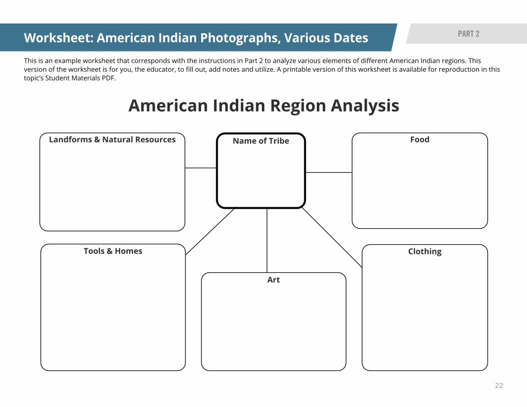
Distribute the American Indian Region Analysis worksheet to students to record their research. Students will write the name of the American Indian tribe in the center circle. They will then record their research for the region on the following topics in the corresponding circle:
• Landforms and natural resources • Food • Clothing • Art • Tools • Homes
After doing research on their American Indian region, each group will share their analysis to the class.
Formative Assessment: Students will return to the initial question in their notebook: Who are American Indians? Students will add to their line of learning from Part 1. They can use pictures and/or words to explain what they have learned. Ask students to also will write a claim about American Indians.
5
6
7
Instructions continued
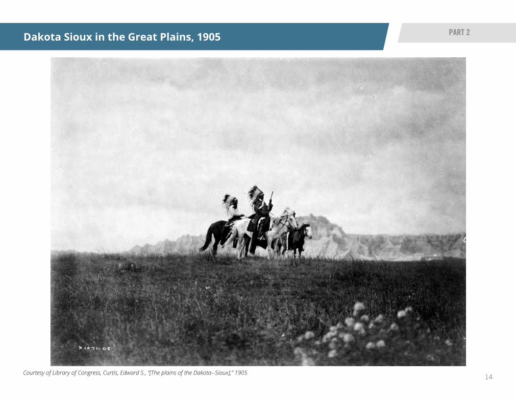
14Courtesy of Library of Congress, Curtis, Edward S., “[The plains of the Dakota--Sioux],” 1905
Dakota Sioux in the Great Plains, 1905 PART 2
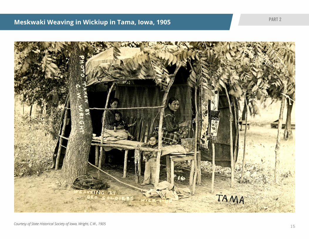
15Courtesy of State Historical Society of Iowa, Wright, C.W., 1905
Meskwaki Weaving in Wickiup in Tama, Iowa, 1905 PART 2
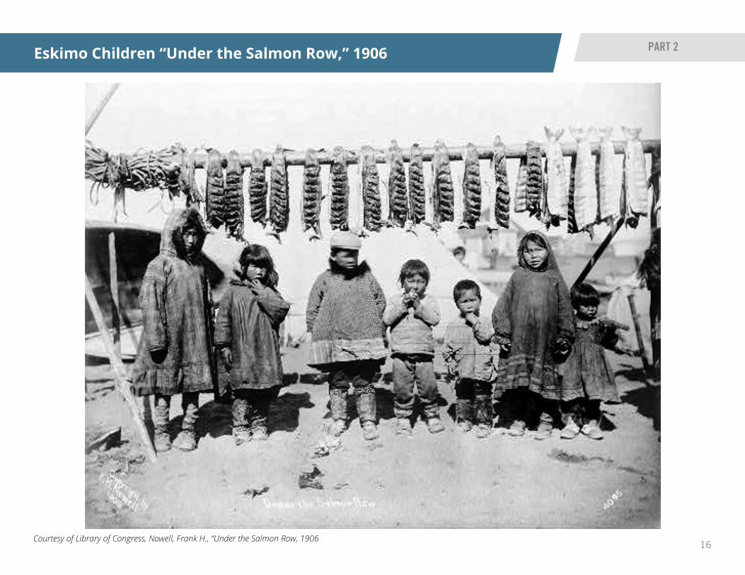
16Courtesy of Library of Congress, Nowell, Frank H., “Under the Salmon Row, 1906
Eskimo Children “Under the Salmon Row,” 1906 PART 2

17Courtesy of Library of Congress, “Harvest Dance, Hopi Indians,” between 1909 and 1919
Hopi Indian Harvest Dance, between 1909 and 1919 PART 2
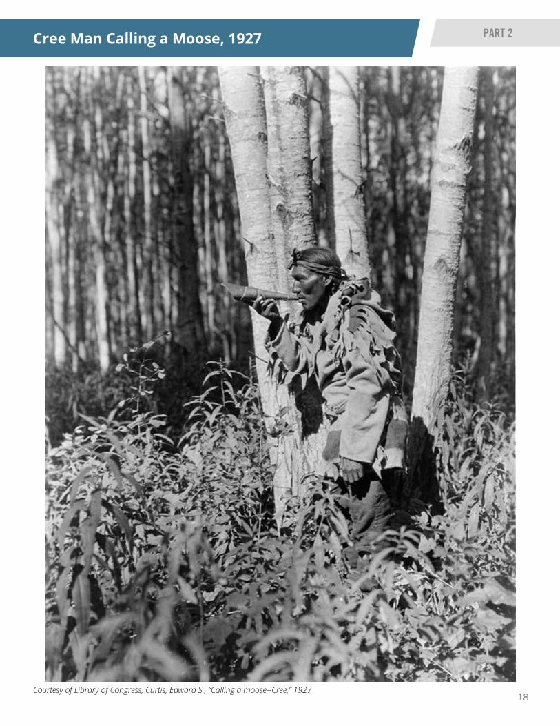
18Courtesy of Library of Congress, Curtis, Edward S., “Calling a moose--Cree,” 1927
Cree Man Calling a Moose, 1927 PART 2

19Courtesy of Library of Congress, “Seminole Indians,” 1936
Seminole Men, Women and Children, 1936 PART 2

20
READ IOWA HISTORY
This is an example K-W-L worksheet that corresponds with the instructions to analyze American Indian images. This directed-learning version of the worksheet is for you, the educator, to fill out, add notes and utilize. A printable version of this worksheet is available for reproduction in this topic’s Student Materials PDF.
K-W-L Chart
K-W-L Chart: American Indian Image Analysis
PART 2 WORKSHEET
K What We Think We Know
W What We Want to Know
L What We Hope to Learn
Stop and Source Why do you think they’re doing this?
Where could you find the answers?
People: How do you think they are feeling?
Objects: When do you think these photos were taken? How do you know?
What are they doing? Questions these photos raise:

21
READ IOWA HISTORY
This is an example K-W-L worksheet that corresponds with the instructions to analyze American Indian images. This blank version of the worksheet is for you, the educator, to fill out, add notes and utilize. A printable version of this worksheet is available for reproduction in this topic’s Student Materials PDF.
K-W-L Chart
K-W-L Chart: American Indian Image Analysis
PART 2 WORKSHEET
K What We Think We Know
W What We Want to Know
L What We Hope to Learn
22
American Indian Region Analysis
Name of Tribe
This is an example worksheet that corresponds with the instructions in Part 2 to analyze various elements of different American Indian regions. This version of the worksheet is for you, the educator, to fill out, add notes and utilize. A printable version of this worksheet is available for reproduction in this topic’s Student Materials PDF.
Worksheet: American Indian Photographs, Various Dates PART 2
Landforms & Natural Resources Food
ClothingTools & Homes
Art

23
READ IOWA HISTORY
Read students the timeline of “How the Meskwaki and Sauki Became Three Separate ‘Sac & Fox’ Tribes.”
Introduce the vocabulary words: reservation, settlement. • Reservations are areas of land American Indians were forced to live on when white settlers took over their land. The main goals of reservations were to bring American Indians under U.S. government control, force them to assimilate and potentially reduce conflict.
• Settlements include land purchased by American Indian tribes from the U.S. government. The tribe, not the government, owns the land. An example of this in Iowa is the Meskwaki Settlement.
Utilize an online satellite map option, such as Google Earth. Locate the Meskwaki Settlement. Have students view the location so they can see where they live in relationship to the settlement.
Instructions continued on next page
1
3
Meskwaki Land Purchases & Timeline
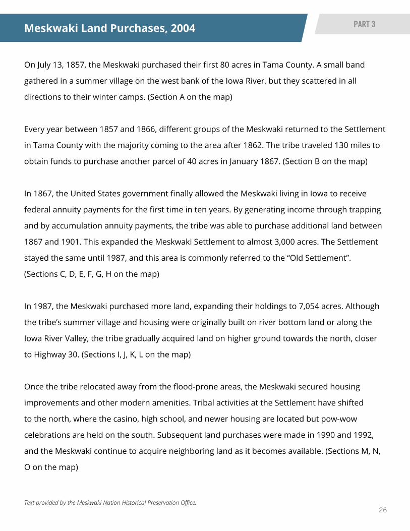
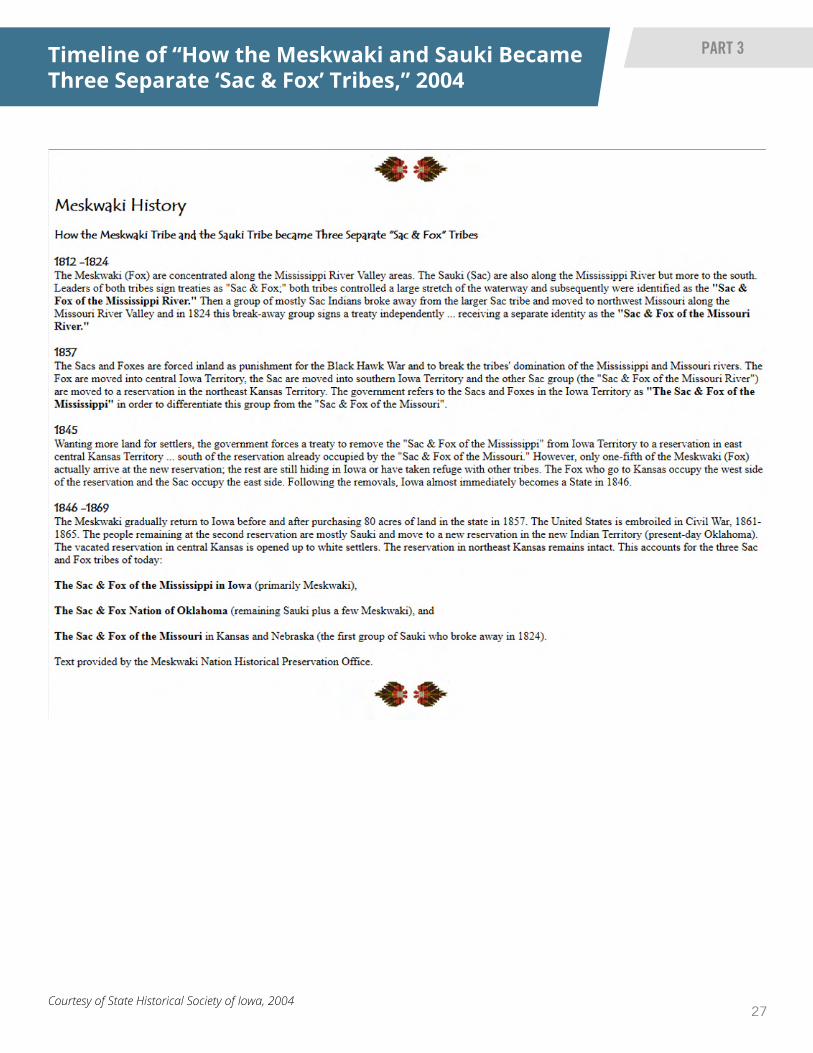
Source BackgroundThe Meskwaki were one of five or six politically-allied Central Algonquian-speaking peoples that also included the Sac (or Sauk), Miami, Kickapoo, Mascouten and possibly Potawatomi. They were named “Renards” (Fox) by the French, who first encountered them in the Great Lakes region in the mid 1600s. Today, they identify themselves as Meskwaki, or “Red Earths.” Their migration to Wisconsin was related to the displacement of native peoples resulting from inter-tribal warfare in the Lower Great Lakes region and competition for the fur trade. Between 1712 and 1737, the French and Meskwaki engaged in an extended period of conflict known as the French and Fox Wars. By 1730, the Meskwaki were forced to abandon their east-central Wisconsin villages and migrate south and west. By 1800, they were firmly established in Iowa. Treated by the U.S. government as a single “Sac and Fox Tribe,” the Meskwaki and the Sac, lost all lands in Iowa through a series of treaty cessions. By 1845, most were removed to a reservation in east-central Kansas, although some Meskwaki remained hidden in Iowa and others soon returned. In 1856, the Iowa legislature enacted a law permitting the Meskwaki to remain in Iowa, and in 1857, they purchased the first 80 acres of their current Settlement in Tama County. This map and accompanying text show the history of land purchases made by the Meskwaki tribe. The timeline, compiled by the Meskwaki Nation Historical Preservation Office, shows how the Meskwaki and Sac tribes became three separate “Sac & Fox” tribes between 1812 and 1869.
OverviewStudents will investigate how the Meskwaki people own their land in Iowa, which means their land is recognized as a settlement rather than a reservation.
PART 3 INSTRUCTIONS
Materials • Meskwaki Land Purchases map and text
• Timeline of “How the Meskwaki and Sauki Became Three Separate ‘Sac & Fox’ Tribes”
Instructions
Unit Compelling QuestionWhat factors, forces or reasons cause people to move from one geographic area to another?
Unit Supporting QuestionWho are American Indians? Who are the Meskwaki?
??
2

24
READ IOWA HISTORY
Meskwaki Land Purchases & Timeline
PART 3 INSTRUCTIONS
Display the ”Meskwaki Land Purchases” map and text for students.
Discuss with students how the Meskwaki came to settle in Iowa. Talk about why the Meskwaki would want to purchase their own land and why they continue to purchase land.
Formative Assessment: After analyzing, use “Meskwaki History” to help students answer questions posed by students. Or have students do a quick write on their thoughts about the question: Who are the Meskwaki?
4
5
6
Instructions continued

25Courtesy of State Historical Society of Iowa, 2004
Meskwaki Land Purchases, 2004 PART 3
26Text provided by the Meskwaki Nation Historical Preservation Office.
On July 13, 1857, the Meskwaki purchased their first 80 acres in Tama County. A small band
gathered in a summer village on the west bank of the Iowa River, but they scattered in all
directions to their winter camps. (Section A on the map)
Every year between 1857 and 1866, different groups of the Meskwaki returned to the Settlement
in Tama County with the majority coming to the area after 1862. The tribe traveled 130 miles to
obtain funds to purchase another parcel of 40 acres in January 1867. (Section B on the map)
In 1867, the United States government finally allowed the Meskwaki living in Iowa to receive
federal annuity payments for the first time in ten years. By generating income through trapping
and by accumulation annuity payments, the tribe was able to purchase additional land between
1867 and 1901. This expanded the Meskwaki Settlement to almost 3,000 acres. The Settlement
stayed the same until 1987, and this area is commonly referred to the “Old Settlement”.
(Sections C, D, E, F, G, H on the map)
In 1987, the Meskwaki purchased more land, expanding their holdings to 7,054 acres. Although
the tribe’s summer village and housing were originally built on river bottom land or along the
Iowa River Valley, the tribe gradually acquired land on higher ground towards the north, closer
to Highway 30. (Sections I, J, K, L on the map)
Once the tribe relocated away from the flood-prone areas, the Meskwaki secured housing
improvements and other modern amenities. Tribal activities at the Settlement have shifted
to the north, where the casino, high school, and newer housing are located but pow-wow
celebrations are held on the south. Subsequent land purchases were made in 1990 and 1992,
and the Meskwaki continue to acquire neighboring land as it becomes available. (Sections M, N,
O on the map)
Meskwaki Land Purchases, 2004 PART 3
27Courtesy of State Historical Society of Iowa, 2004
Timeline of “How the Meskwaki and Sauki Became Three Separate ‘Sac & Fox’ Tribes,” 2004
PART 3

28
READ IOWA HISTORY
Divide the class into three groups. Each group will analyze the three images using a K-W-L (Know, Wonder, Learn) worksheet.
Each small group will share their image to the class. Ask students in each group the following questions. Encourage them to answer based on information in the images’ sourcing and descriptions listed above:
• Who is in the image? What is happening? • When was this image taken/created? Where is this? • What questions do you have about the image?
Formative Assessment: Have students expand on their thoughts about the question: Who are the Meskwaki?
1
2
33
Meskwaki Life and Culture
Source BackgroundsSource 1: The news clipping shows a composite picture showing eight Sac and Fox Native American men, all member of Company H in the 186th Infantry, using their Meskwaki language to be “code talkers” during World War II.
Source 2: The photo shows Meskwaki men in tradition dress participating in the powwow celebrations in 1953. The annual powwow celebration is a time for renewing contacts within and outside the Meskwaki tribe.
Source 3: This is the Meskwaki Settlement School on the settlement. The Sac and Fox Settlement School was established as a day school and became part of the South Tama County Community School District. However, it closed in 1972. In 1980, the Sac and Fox Settlement School was established a tribal school. The Meskwaki Settlement School was a tribally-controlled school. The mission of the school since the 1980s has been, and continues to be, the preservation of the Meskwaki culture and language and preparation of all students to become productive citizens.
OverviewStudents will investigate different elements of the life and culture of the Meskwaki people, who are the only federally-recognized American Indian tribe currently based in Iowa.
PART 4 INSTRUCTIONS
Materials • K-W-L chart
• “Meskwaki Code Talkers” image and caption
• “Meskwaki Powwow Celebration in Tama, Iowa” image
• “Meskwaki New Settlement School” image
Instructions
Unit Compelling QuestionWhat factors, forces or reasons cause people to move from one geographic area to another?
Unit Supporting QuestionWho are American Indians? Who are the Meskwaki?
??

29Courtesy of State Historical Society of Iowa, Marshalltown Times Republican, 26 February 1941
Meskwaki Code Talkers, February 26, 1941 PART 4

30Courtesy of State Historical Society of Iowa, 1953
Meskwaki Powwow Celebration in Tama, Iowa, 1953
PART 4

31Courtesy of State Historical Society of Iowa, Date Unknown
Meskwaki New Settlement School, Date Unknown PART 4

32
READ IOWA HISTORY
This is an example K-W-L worksheet that corresponds with the instructions to analyze images showing different elements and contributions of Meskwaki culture. This directed-learning version of the worksheet is for you, the educator, to fill out, add notes and utilize. A printable version of this worksheet is available for reproduction in this topic’s Student Materials PDF.
K-W-L Chart
K-W-L Chart: Meskwaki Life and Culture
PART 4 WORKSHEET
K What We Think We Know
W What We Want to Know
L What We Hope to Learn
Stop and Source Why do you think they’re doing this?
Where could you find the answers?
People: How do you think they are feeling?
Objects: When do you think these photos were taken? How do you know?
What are they doing? Questions these photos raise:

33
READ IOWA HISTORY
This is an example K-W-L worksheet that corresponds with the instructions to analyze images showing different elements and contributions of Meskwaki culture. This blank version of the worksheet is for you, the educator, to fill out, add notes and utilize. A printable version of this worksheet is available for reproduction in this topic’s Student Materials PDF.
K-W-L Chart
K-W-L Chart: Meskwaki Life and Culture
PART 4 WORKSHEET
K What We Think We Know
W What We Want to Know
L What We Hope to Learn

34
READ IOWA HISTORY
Lesson Summative Assessment
Proficient
Is able to match and explain statements to a map of the Meskwaki: how they purchased land in Iowa, saved federal money and more earned through fur trading to over time purchase more land while evidence from sources within the lesson plan; explanation is accurate and complete
Developing Partially answers question, or has mixture of some accurate and some inaccurate ideas
Beginning Minimal or insufficient answer to question and/or ideas are very inaccurate
ASSESSMENT
Print enough Meskwaki Land Purchase maps for each student in the class to color. Students will use the map to explain why the Meskwaki move(d) and how natural resources helped them. Make sure students have access to colored pencils or crayons to color the map.
Print out and distribute the “Meskwaki Land Purchases” worksheet for students.
Work as a class to fill out the worksheet and color the map. As students number the land purchase facts from 1 to 5 (1 being the oldest, 5 being the newest addition), they will color in that section in the Meskwaki land purchase map.
After completing the worksheet, instruct students to write about their thoughts and what they learned about the Meskwaki and American Indians in these lessons.
Optional: Students can share their thinking and learning on an online, digital platform.
3
4
5
Assessment Scoring Options
Assessment Instructions1
2
Unit Compelling QuestionWhat factors, forces or reasons cause people to move from one geographic area to another?
Unit Supporting QuestionWho are American Indians? Who are the Meskwaki?
??

35
READ IOWA HISTORY
This is an example lesson summative worksheet for students to track the history of Meskwaki land purchases. While students can complete their answers on a piece of paper or in a notebook, this sheet can be projected, handed to students and/or just used by the educator to guide the students’ free response activity.
Meskwaki Land Purchases
WORKSHEET
Lesson Summative Assessment
Number the story Statements about the Meskwaki
Every year between 1857 and 1866, different groups of the Meskwaki returned to the settlement in Tama County. The tribe purchased 40 acres in January 1867.
Color on the map: ____________________________________
In 1986, the Meskwaki purchased more land. They now have 7,054 acres with more of it being north, closer to Highway 30.
Color on the map: ____________________________________
The Meskwaki made improvements to houses on the settlement. Tribal activities at the settlement have moved to the north, where the casino and high school
are located, but powwow celebrations are held on the south side. More land was purchased in 1990 and 1992.
Color on the map: ____________________________________
In 1857, the Meskwaki purchased their first 80 acres in Tama County. A small band gathered in a summer village on the west bank of the Iowa River.
Color on the map: ____________________________________
The United States government finally allowed the Meskwaki living in Iowa to receive federal money for the first time in 10 years. With the federal money and money earned by trapping and hunting off the land, the tribe was able to
purchase more land between 1868 and 1901. Now, they have almost 3,000 acres.
Color on the map: ___________________________________
Use the map to help you put the statements in order to tell the story of the migration and land purchases of the Meskwaki people. Label the color on the map that matches each statement.

36
Lesson Summative Assessment EXAMPLE MAP

37
Vocabulary Flashcards
American Indian Meskwaki
Settlement
AMERICAN INDIANS
READ IOWA HISTORY
READ IOWA HISTORY
READ IOWA HISTORY
READ IOWA HISTORY
Reservation

38
Meskwaki American Indian
Reservation Settlement
The Meskwaki people (sometimes spelled “Mesquakie”) are of Algonquian origin from the Eastern Woodland Culture areas. The Meskwaki spoken language is of similar dialect to the Sauk and Kickapoo and they are working hard to maintain it.
A reservation is a legal designation for an area of land managed by a federally-recognized American Indian tribe under the U.S. Bureau of Indian Affairs rather than the state governments of the United States in which they are physically located.
A member of any of the indigenous peoples of the Americas.
An area of land purchased by a federally-recognized American Indian tribe.

39
Vocabulary Flashcards AMERICAN INDIANS
READ IOWA HISTORY
READ IOWA HISTORY
READ IOWA HISTORY
READ IOWA HISTORY
Removal

40
Removal
American Indian removal was a forced migration in the 19th century whereby American Indians were forced by the U.S. government to leave their ancestral homelands to lands west of the Mississippi River, specifically to a designated Indian Territory.

41
READ IOWA HISTORY
Additional Resources for Educators
American Indians and Westward Expansion Primary Source SetThis primary source set is a digital collection from the State Historical Society of Iowa that features multiple primary and secondary sources that showcase American Indians and the impact of westward expansion.
“The Long Way Home” Article from The Goldfinch: Iowa History for Young PeopleThis article focuses on the life of a young Meskwaki woman. The Goldfinch was published quarterly by the State Historical Society of Iowa from 1975-2000.
Sac And Fox Native American Fact SheetThe website was written for young people to learn about the Fox and Sacs tribes for schoolchildren.
A Visual Dictionary of the Native Communities by Bobbie KalmanThis book provides an overview of American Indians before their contact with the Europeans, discussing the shelter, food, clothing, tools and activities of tribes in such regions as the Eastern Great Lakes, the Great Plains and the Pacific Northwest.
AMERICAN INDIANS