an african metropolis: the imploded territoriality of kinshasa
TRANSCRIPT
Investigaciones Geográficas, Boletín del Instituto de Geografía, UNAMISSN 0188-4611, Núm. 80, 2013, pp. 98-110
An African metropolis: the imploded territoriality of KinshasaReceived: 25 August 2012. Final version accepted: 24 October 2012.
Fabiana D´Ascenzo*
* Department of Historical Sciences, University of Naples “Federico II”.
Abstract. The peripheral and segmented nature of the urban network and communication routes in the Democratic Republic of Congo condemns the country to being outward-oriented, allowing little room for integration of national ter-ritory and favouring the neighbouring inter-African context. In this situation, the city of Kinshasa is forced to carry not just the weight of its role as capital city but also the burden associated with a territorial expansion that has occurred very much in the post-Independence style, where a veritable territorial implosion has resulted due to the existence of an
inward-looking system of relationships. Based on field work, this article discusses the spatial factors existing in the social context under consideration, and identifies, as a result of the interaction of those factors, a complex territoriality that affects all the various facets of the urban fabric.
Key words: Kinshasa, urban organisation, spatial expansion, imploded territoriality, peripheral urbanisation, outward-oriented relationships.
Una metrópolis africana: la implosión territorial de Kinshasa
Resumen. El carácter periférico y segmentado de la red urbana y de las vías de comunicación en la República De-mocrática del Congo condena al país a orientarse al exterior, lo cual ayuda muy poco a la integración del espacio nacional y da preferencia al contexto interafricano limítrofe. En este contexto, la ciudad de Kinshasa se ve obligada a gestionar el peso no solo de su papel de capital sino también de una expansión espacial ocurrida en un estilo típico de la post-independencia; ésta ha coincidido además con una implosión territorial fundada en un sistema de relaciones
centrípeto. Basado en el trabajo de campo, el ensayo pone en evidencia las lógicas espaciales transmitidas por la rea-lidad social considerada, e identifica, como resultado de la interacción de éstas, una territorialidad compleja que abarca las distintas articulaciones de la trama urbana.
Palabras clave: Kinshasa, organización urbana, explosión espacial, implosión territorial, urbanización periférica, relaciones orientadas al exterior.
Investigaciones Geográficas, Boletín 80, 2013 ][ 99
An African metropolis: the imploded territoriality of Kinshasa
IntRodUctIon
Surrounded by nine countries and 9 000 km of borders, and with a mere 40 km of coastline, the Democratic Republic of Congo is like an enor-mous enclave nestled at the centre of the African continent. The position occupied by this country in Central Africa and the colonial heterocentric territorialisation that led to the process of urbani-sation have contributed to the role of the capital city of Kinshasa within the framework of the nation as a whole.1
During the colonial period, urbanisation sought to meet the needs of an economy that was based on exploitation and designed around the export of raw materials. This brought about the development of urban centres associated with mining activities, and therefore situated in important mining areas, or of centres with a commercial focus, and therefore located in areas that were strategic for communica-tion and transport. The capital city itself, Kinshasa, owes its fortune to its privileged position on the river, since this opens up thousands of kilometres of potentially navigable routes, along the Congo River and certain of its important tributaries.
Similar dynamics have affected the cities of Ki-sangani, Bandundu, Mbandaka, Kindu, Boma and Matadi, with Matadi being the location of the most important river port in the country, and the only one that can conduct maritime trade with inland areas. The centres of Lubumbashi and Mbuji-Mayi, in the provinces of Katanga and Eastern Kasai, res-pectively, owe their development to the existence of mineral resources (namely, copper and diamonds) in those areas, as do the secondary cities of Likasi and Kolwezi, in the southern part of the province of Katanga.
Colonialism also resulted in substantial human movement, in all cases corresponding to the same logic that has made the rivers, railways, roads, plantations and cities part of a single fabric oriented towards the exterior. In any case, despite represen-
1 Heterocentric territorialisation is a process of production and usage of a territory, guided by an external social logic that determines the outcome of the process through asym-metrical power relationships (Turco, 1988:145-149).
ting one of the factors driving urbanisation, the colonial presence developed an urban network that, even today, contrasts the active, populous border areas of the country with the virtually uninhabited central regions. Therefore, large uninhabited areas, without infrastructures and in an almost complete state of abandonment, exist in contradistinction to overcrowded urban areas, which lack facilities to ensure an acceptable standard of living for their inhabitants. The country thus suffers the effects of an uneven population that, also because of its distribution, cannot represent adequate human po-tential for the satisfactory territorial management of the country (Kakese, 2006:85-91).
PeRIPheRAl URbAnIsAtIon And exteRnAl InflUences
The urban network is made up of big cities such as Kinshasa, Mbuji-Mayi, Lubumbashi and Kisan-gani, regional centres such as Matadi, Kananga, Bukavu, Mbandaka, Bandundu, Goma and Kindu, and other centres of local importance, but of lower rank, often more rural in nature. Nevertheless, that network does not function as a network but rather as a series of urban points of reference, as a result of the deficiencies in the transportation and road sector, deficiencies that hinder the organisation of the various territories in this vast country (Bureau d’Études et d’Aménagement Urbains-BEAU, 1991:21; Bruneau, 1995:103-113; Wolff et al., 2001:10; de Saint Moulin, 2007:41-65).
Taking into consideration the most important cities, it is possible to identify significant core centres. The highest hierarchical level, which is unlike any other urban context within the country, is represented by Kinshasa-Matadi, in the west, which forms the central axis for concentration and coordination, as a result of its two functions as a capital city and an international river port. This city is responsible for a substantial portion of the import-export activities of Congo, especia-lly from and to Europe. In the south-east of the Upper Katanga region lies another hub represen-ted by Lubumbashi, Likasi and Kolwezi, urban settlements that are associated with the mineral
100 ][ Investigaciones Geográficas, Boletín 80, 2013
Fabiana D´Ascenzo
extraction of copper. Between the two areas are the diamond fields of Western Kasai and Eastern Kasai, with their respective capitals, Mbuji-Mayi and Kananga.
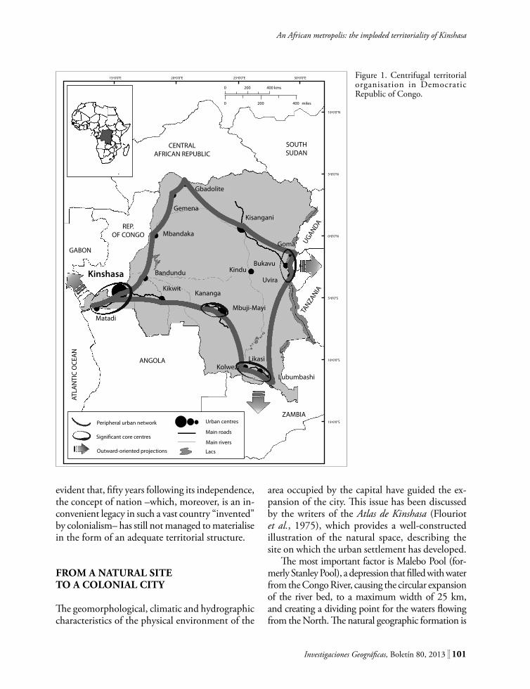
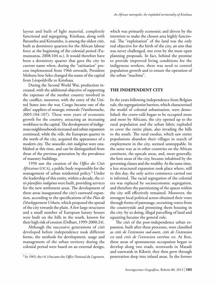
The remainder of the country is dotted with small towns and big villages that are generally situated along the rivers or between other bigger cities on the main roads, beyond which there are vast non-urban areas characterised by a lack of significant urban nuclei. The hypothetical linking of these lines creates what has been defined as a “productive circle” (Bruneau and Simon, 1991:7 ss.), a peripheral model of territorial organisation that is outward-oriented and that results largely from the “exploitation” of Congo that took place during the Belgian colonialist period. This starts at the Atlantic Ocean and proceeds towards Kinshasa, through the province of Bandundu and the two Kasais to Lubumbashi before heading up towards the Great Lakes region in the East, and finally mo-ves westwards and, at Kisangani, heads downwards once again along the river, towards the capital city.
This type of territorial structure significantly influences the way the country functions, on a domestic level and also in terms of international relations, both African and non-African. Modes of development directed away from the centre (centrifugal) prevail over integration factors and are represented by three spheres of influence: one in the West, concentrated on Kinshasa and looking towards the Atlantic, via Matadi; one in the East, which is almost completely lacking in links with the capital city and is oriented towards the Indian Ocean; and one in the South, where the copper mines are located and which is focussed towards southern Africa (Figure 1).
The peripheral nature of urbanisation in the Democratic Republic of Congo is reinforced by its segmented communication routes, which are composed of river, road and railway junctions and sub-connections; once again, this situation results from the definition of the original colonial struc-ture. This road network is an integral part of the organisational model for an outward-oriented space – a structure with the sole objective of attaining an efficient colonial design to such an extent that it is still functioning today, forcing the atrophy of
inland regions and continuous projection beyond the country’s borders.2
The various external influences, which domi-nate all areas of the country’s territory, act as a series of forces, each of which pulls in its own direction, creating a tendency to fragment that, in clashing with any effort to integrate, condemns the entire country to an underestimation of its own resources and potential. The absence or weakness of connec-tions among the urban settlements hinders the development of intermediate centres and does not offer any advantages for large cities, forcing them, rather, to endure greater burdens, in demographic and other terms.
Broadly speaking, it could be said that the only strong relationships existing from Kinshasa seem to be those with the capital of Bas-Congo, Matadi, and the city of Kikwit, in the province Bandundu. In both cases, the urban centres have a reciprocal link with the rural centres that are spread within reach of the road network connecting them to the capital, allowing food supplies to reach it, and, vice versa, making it possible for these centres to be supplied with consumables coming from Kinshasa. Naturally, in addition to this close relationship with Matadi, there is also the major role played by the port, above all in terms of import activi-ties. However, in both cases, the relationships are strong and exist in both directions, including those with Kikwit. The connections between Kinshasa and the other provincial capitals are very much weaker: these cities are too distant and too poorly linked to allow an efficient exchange system with the capital, or they in turn have limited interest in the metropolis, given their involvement in more expedient international relations.
With regard to Kinshasa, it could be said that its strongest relationship is with itself, despite its dependence on some other provinces, in particular for its food supply. Indeed, the capital seems to be focussed inwards, on itself and its own activities, or, in any case, oriented towards external areas that are neither Congolese nor African. It is therefore
2 For more in-depth reading on the structuring of the te-rritory and the regionalisation of the Democratic Republic of the Congo, refer to Pourtier (2003:45-54).
Investigaciones Geográficas, Boletín 80, 2013 ][ 101
An African metropolis: the imploded territoriality of Kinshasa
15º0'0"E 20º0'0"E 25º0'0"E 30º0'0"E
10º0'0"N
5º0'0"N
0º0'0"N
5º0'0"S
10º0'0"S
15º0'0"S
0 200 400 kms
0 200 400 miles
CENTRALAFRICAN REPUBLIC
SOUTHSUDAN
REP.OF CONGO
GABON
ANGOLA
ATLA
NTI
C O
CEA
N
ZAMBIA
TANZA
NIA
UGANDA
Kinshasa
Matadi
Gbadolite
GemenaKisangani
Mbandaka
Bandundu
Kikwit
Goma
BukavuKindu
Uvira
Kananga
Mbuji-Mayi
LikasiKolwezi
Lubumbashi
Peripheral urban network
Signi�cant core centres
Outward-oriented projections
Urban centres
Main roads
Main rivers
Lacs
Figure 1. Centrifugal territorial organisation in Democratic Republic of Congo.
evident that, fifty years following its independence, the concept of nation –which, moreover, is an in-convenient legacy in such a vast country “invented” by colonialism– has still not managed to materialise in the form of an adequate territorial structure.
fRom A nAtURAl sIte to A colonIAl cIty
The geomorphological, climatic and hydrographic characteristics of the physical environment of the
area occupied by the capital have guided the ex-pansion of the city. This issue has been discussed by the writers of the Atlas de Kinshasa (Flouriot et al., 1975), which provides a well-constructed illustration of the natural space, describing the site on which the urban settlement has developed.
The most important factor is Malebo Pool (for-merly Stanley Pool), a depression that filled with water from the Congo River, causing the circular expansion of the river bed, to a maximum width of 25 km, and creating a dividing point for the waters flowing from the North. The natural geographic formation is

102 ][ Investigaciones Geográficas, Boletín 80, 2013
Fabiana D´Ascenzo
characteristic of the surrounding region, an area of ho-llows and flats, bounded by hills that, in geographical and political terms, stretch between the territories of the Democratic Republic of Congo (Congo-Kinshasa) and the Republic of Congo (Congo-Brazzaville). South of this plain, the city developed and expanded over the course of the decades (Lumenga, 1995:15-16). Another natural element characterising the area in question is the number of rivers by which it is crossed. The two most important rivers, the Ndjili and the Nsele, have profoundly marked this site -as they flow towards the Congo River, they cut across the plain from North to South, cutting it into two separate sections. Finally, hills surround the plains on the southern side, giving the space the sense of a natural amphitheatre (Lelo, 2008:33).
Originally, the urban structure began to develop according to a dualist model –European quarters/Afri-can quarters– characteristic of the entire organisational plan of the city. The commercial and administrative power developed on Mount Ngaliema and Pointe de la Gombe, overlooking the pool. The European settlements and their progressive expansion were matched by the construction of areas inhabited by African workers situated in the South, on the lower flood plains: these were the future cités, which were of-ten built on ancient bantu villages (De Saint Moulin, 1971:83-119) and were elements of a type of “proto-urbanisation” that was necessary for the mechanism of territorial construction during the colonialist period (De Maximy, 1984:59).
Finally, the principle of zonage guided the entire physiognomy of the urban landscape according to areas of different types: European residential quarters, African residential quarters, industrial areas and, between the first two, a clearly-defined buffer zone. This created an urban plan based on segregation, dividing the city into ville européen-ne, cité industrielle, zone neutre and cité indigène. Gradually, these areas became the current muni-cipalities of Kinshasa and, in some cases, the only thing that remains of the original bantu villages is the names that were passed on to the quarters of the modern capital.
After the long evolution of the urban fabric, the ville-province of Kinshasa currently has 24 municipalities. Their classification, based on their
chronological development and their typology, defined in due course by Jean Flouriot (1975), was supplemented after the expansions of the inhabited areas that took place in the period after the publi-cation of the Atlas. The subsequent development of new quarters and the expansion of existing ones, and the various levels of architectural development, infrastructure and services in the municipalities, brought about differences, in some cases substantial ones, in cités of the same category. For this reason, the categorisation indicated here should not be considered to be rigid or exhaustive, but rather as a criterion that can be used for guidance when studying the construction of the city in terms of time and space. The aim is to provide an idea of the structure of the urban environment, including in terms of the causes that resulted in its organisation.
The first subdivision distinguishes the cités that formed before independence from those that for-med after this time. Then, within these two periods, some “generations” of cités were identified, cités forming the basis of the urban fabric as it still exists today. The cités européennes, i.e. the upscale areas, established by the first colonial settlements, are situated at the northern end of the urban agglome-ration, overlooking Malebo Pool. Amongst them is the municipality of La Gombe (commonly known as centre-ville), which plays a leading role as an ad-ministrative and commercial hub, a financial office district and business centre, a seat for banks, offices and companies, a hub for port, diplomatic and po-litical activities, and a top-end residential area whe-re the educational and cultural institutions and the main accommodation structures are concentrated. This municipality is connected to the arterial routes through the city, and therefore there are traffic jams in the mornings on the roads leading to La Gom-be and in the opposite direction in the evenings.
During the colonial period, the first shipyards and other European facilities developed westwards and eastwards, parallel to the river, while the re-sidential areas initially developed southwards and then continued eastwards. The initial expansion of the urban area, towards the South, consisted of the anciennes cités indigènes, which originated between the years 1910 and 1930 as “work camps”: these were all identical, with an orthogonally-planned
Investigaciones Geográficas, Boletín 80, 2013 ][ 103
An African metropolis: the imploded territoriality of Kinshasa
layout and built of light material, completely functional and segregating. Kinshasa, along with Barumbu and Kintambo, is among the oldest cités, built as dormitory quarters for the African labour force at the beginning of the colonial period (Fu-munzanza, 2008:104 ss.). It would therefore have been a dormitory quarter that gave the city its current name when, during the “zairisation” pro-cess implemented from 1966 onwards, President Mobutu Sese Seko changed the name of the capital from Léopoldville to Kinshasa.
During the Second World War, production in-creased, with the additional objective of supporting the expenses of the mother country involved in the conflict; moreover, with the entry of the Uni-ted States into the war, Congo became one of the allies’ suppliers of strategic minerals (Vanthemsche, 2005:104-107). These were years of economic growth for the country, attracting an increasing workforce to the capital. The development of indige-nous neighbourhoods increased and urban expansion continued, while the ville, the European quarter in the north of the city, acquired the appearance of a modern city. The nouvelles cités indigènes were esta-blished at this time, and can be distinguished from those of the previous generation by the prevalence of masonry buildings.
1950 saw the creation of the Office des Cités Africaines (OCA), a public body responsible for the management of urban residential policy.3 Under the leadership of this entity, within a decade, the ci-tés planifiées indigènes were built, providing services for the new settlement areas. The development of these areas inaugurated the city’s eastward expan-sion, according to the specifications of the Plan de Développement Urbain, which proposed the spread of the city towards the plain. A few large structures and a small number of European luxury houses were built on the hills in the south, known for their high risk of erosion (Delbart, 1999-2000:24).
Although the successive generations of cités developed before independence took different forms, the methods for development, usage and management of the urban territory during the colonial period were based on an external design,
3 In 1965, the OCA became the Office National du Logement.
which was primarily economic and driven by the intention to make the chosen area highly functio-nal. The “exploitation” of the land was the only real objective for the birth of the city, an aim that was never challenged, not even by the most open planning proposals. In fact, behind the promise to provide improved living conditions for the indigenous workers, there was need to control population growth and to ensure the operation of the urban “machine”.
the IndePendent cIty
In the years following independence from Belgian rule, the segregationist barriers, which characterised the model of colonial urbanisation, were demo-lished: the centre-ville began to be occupied more and more by Africans, the city opened up to the rural population and the urban fabric exploded to cover the entire plain, also invading the hills to the south. The rural exodus, which saw entire populations abandon their villages in search of employment in the city, seemed unstoppable. In the same way as in other countries on the African continent, the upscale areas, and, more generally, the best areas of the city, became inhabited by the governing classes and the wealthy. At the same time, a less structured expansion took place where, still to this day, the only active commerce carried out is informal. The racial segregation of the colonial era was replaced by socioeconomic segregation, and therefore the partitioning of the spaces within the city still effectively remained. Moreover, the strongest local political actors obtained their votes through forms of patronage, recruiting voters from the countryside and promising them housing in the city: by so doing, illegal parcelling of land and squatting became the general rule.
The cités of the post-independence urban ex-pansion, built after these processes, were classified as cités de l’extension sud-ouest, cités de l’extension est and cités de l’extension extrême est. At first, these areas of spontaneous occupation began to develop along two roads, westwards in Matadi and eastwards in Kikwit; they then grew through penetration deep into inland areas. In the former
104 ][ Investigaciones Geográficas, Boletín 80, 2013
Fabiana D´Ascenzo
case, the south-west urban expansion took over the hillsides that were subject to erosion; in the latter case, the new neighbourhoods expanding eastwards spread exponentially, so far away from the roads that it is now necessary to walk long distances to reach a place served by public transport (Delbart and Wolff, 2002:56-58).
The urban-rural municipalities of Maluku and Nsele, which together cover the largest surface area of the ville-province of Kinshasa, are administrati-vely equivalent to the cités de l’extension extrême est. The municipality of Nsele constitutes a sort of vast peripheral area, some tens of kilometres away from the actual urban agglomeration. Its spread along the road shows that the eastward expansion, away from the city, is still taking place, although a process of densification is under way. Indeed, in the large expanses of sand in the interior, semi-rural neigh-bourhoods are developing without access to the road network and mostly characterised by maison d’attente, unfinished buildings that are often only built to ensure the effective occupation of the land. Nsele, a transitional point between urban and rural areas, is a hybrid space: a place that is still not a city but is no longer a village. On the other hand, the municipality of Maluku occupies about three quar-ters of the entire surface area of the ville-province of Kinshasa and includes a large portion of the Plateau des Bateke, a vast plateau scattered with villages of various sizes. The best known and largest of these are situated along the road that leads to the city of Kikwit, in the province of Bandundu.
In general, the cités de l’extension sud-ouest, ci-tés de l’extension est and cités de l’extension extrême est are characterised by their size, the irregularity and erratic nature of the built-up areas, the oc-cupation of sandy and erosive lands, the lack of infrastructure, the successive clean-up and regu-larisation operations that tend to pursue the city, the significant presence of poor rural populations from other provinces, and the low socioeconomic status of the people that settle there. The post-in-dependence society is therefore expressed through territorial forms that are driven, at least apparently, by a design that is the opposite of what has gone before. Nevertheless, the development and use of the territory continue to be the same and take the
form of successive parcelling actions that follow the colonial model, although the original sense of that model no longer exists. The real social strategy in the post-colonial phase seemed to be that of stor-ming the city and appropriating territorial gains, the benefits of which were never shared with the local populations. This strategy is not interested in making the territory function but rather in tout court occupation and, while the colonial construct manifested itself through the phenomenon of urbanisation, that of Independent Congo mostly manifests itself through the indiscriminate use of urban spaces.
All the processes that have been described above also have consequences for the urban and non-urban communication system. For one thing, the roads in Kinshasa all converge on the centre-ville, where work and services are concentrated. Inevitably, this has an impact on the urban transport system, concentrating the flows towards this appealing area. The road network is sufficiently coordinated, even in the cités furthest north built before 1960, but has not followed the territorial development of the post-independence city. The interior of the vast municipalities to the east is largely inacces-sible by vehicles, which is the reason why all the peripheral areas suffer from a significant lack of transport services, thus exacerbating the depen-dence already existing in these peripheral areas (Pain, 1984:75-77 ; Godard, 1985:41-57; Mwanza wa Mwanza, 1995:123-134; 1997: 87 ss.; BEAU, 2003:4-13). Moreover, erosion and floods, along with lack of road maintenance, are causing a gene-ralised deterioration of the asphalted urban roads.
The most significant aspect is structural, and concerns the opposition between the “centrifugal” development of urban settlement and the “centripe-tal” action exerted by the concentration of activities in a few centres that are constantly increasing their power of attraction, above all in the centre-ville, which is “central” in the way it functions but not in terms of location. Had it been central, this would at least have enabled a more even distribution of distances required to reach other parts of the city. With regard to the external road network, there are two main roads to Kinshasa: one in the west, based on the national road route from the city of
Investigaciones Geográficas, Boletín 80, 2013 ][ 105
An African metropolis: the imploded territoriality of Kinshasa
Matadi, and one in the east, connected to the same route nationale but which travels in the direction of the province of Bandundu (a section which is commonly known as the road to Kenge or to Kikwit). These sections of the route nationale cons-titute the roads by which supplies reach the city, and trace the route that guided the urban expan-sion of the capital over the course of the decades.
The model for territorial organisation that underpins the territory of the country nationally, resulting from peripheral urbanisation and road segmentation, seems to recur, to a certain extent, even on an urban level. In the same way as Kinshasa is the main hub within the country, the centre-ville, by focusing all the flows of the capital city on itself, has the same concentrating effect in the city that can be seen on a national scale. At the same time, the weak interurban relationships between municipalities and neighbourhoods transform the territory of the city into an internally unconnec-ted fabric, to the extent that even the privileged relationships within the city itself are limited to important exchanges that occur only between a few of its most clearly identifiable areas.
URbAn teRRItoRIAlIty
The reinterpretation of the urban environment of Kinshasa discussed here is intended to identify a specific territoriality, the complexity of which forces us to take into consideration the various aspects that define the perception, use and deve-lopment of territory within the capital city.4 This interpretive approach uses the development of the city, in terms of space and time, to show how the configuration adopted by the urban mass reflects and conditions, to a certain extent, the location of the social dynamics that predominate in the different sectors of the capital.
4 Territoriality brings together and summarises the methods through which, within a defined geographical space, various collective entities pursue specific goals through a series of strategies and action systems; in this context, the territory in question functions as a relational field, where, inevitably, power circulates (Raffestin, 2007:23-31).
The attempt to identify and recognise the va-rious types of relationships that inhabitants have with the capital has highlighted certain structurally representative geographical aspects. Notwithstan-ding their peculiarities, these aspects help to define an urban territoriality that is specifically expressed as an interactive construct made up of those specific traits. The definition of each territorial characteri-sation includes, depending on the case and from time to time, elements belonging to the local or global sphere, inclusive and exclusive dynamics, lasting heritage from the past or emerging forms of territorial organisation.5 Finally, these distinctive traits can be located, and therefore found, either in a specific portion of the urban territory or, otherwise, spread over the entire agglomeration, permeating its fabric.
The first and the most obvious aspect of this urban geography relates to the distinction between the ville and the cités, that is, between the working city –where most of the institutions, administrative services and the official commerce activities are situa-ted– and the city experienced by the inhabitants and their neighbourhoods, representing everything that is not found within the ville. This bipolarity, which forms part of the entire urban fabric, is a colonial legacy that is still active and visible, the product of territorial development and use that were established by and looking towards the exterior, as the result of an intrusion that occurred through asymmetrical power relationships, and which have remained crys-tallised within the territory in the present day. Based on control and exclusion, this partitioning between the ville and cités was incorporated structurally in the development of the urban space. For this reason, it was never challenged by the behaviour of the social and territorial entities present in this environment, who worked within it and absorbed the associated organisational dynamics.
5 As regards inclusion/exclusion, territoriality is considered to be passive or “negative” when, using certain control strategies and a system of rules that guides them, it tends to exclude the practices of certain social actors in a geogra-phical area; on the contrary, territoriality is said to be active or “positive” when it derives from a collective action that aims to include those practices. For more about this theme refer to Governa (2005:55-59).

106 ][ Investigaciones Geográficas, Boletín 80, 2013
Fabiana D´Ascenzo
In the study of the African colonial cities, bipolarity remains an essential analytical crite-rion, because the urban system tends to preserve this two-sided imprinting in terms of space and function. Nonetheless, this interpretation is no lon-ger sufficient to understand the modern capital city, because the territorial structure has become more complex internally. Although this invasive aspect occurs on an urban scale, it is possible to identify other traits of equal significance on a smaller scale.
For instance, the concentration of activities linked to the international sector makes the centre-ville a hub for external relations. In this area of the city, territorial forms take on a markedly global aspect that involves powerful entities, both local and foreign, namely political institutions, the di-plomatic corps, international NGOs, commercial companies, the United Nations contingent in Congo (MONUC), businessmen and also Indian, Lebanese, Chinese and Arabic traders, who support and consolidate the function attributed to this section of the city through the colonial structure. The global connections, which are predominant in the centre-ville, are driven by a logic that is largely external and is linked to international structures and current geopolitical horizons, both internatio-nal and African, in which the role of the country is constantly being redefined.
On the other hand, this area also attracts a num-ber of marginal actors who choose to operate there specifically because of its transnational character, operating from within and, therefore, contradicting the original dualism. They do not resolve or elimi-nate that dualism, but rather exploit it, therefore bending a de facto situation to fit their own needs. The centre-ville, where the spending power of the inhabitants is greater and money has a different value, is thus visited on a daily basis by groups of people from the lower levels of the social scale, who flood in to offer their products or services, in the hope of gathering at least the “leftovers” of a capital city that, more than anywhere else, certainly seems to be a local hub in a global network.6
6 Of course, if we consider the global context, i.e. the various types of relationships that the centre-ville of Kinshasa has with the world through its privileged protagonists –relation-
Another kind of process is developing in the cités established before independence: over time, on the ancient orthogonal structure of the colonial land parcelling system, new hubs have been develo-ped that play a role in coordinating the urban space. These centres have been developed at crossroads between the most important roads,7 at peripheral dividing points8 or at large urban markets,9 and create a flurry of activities and services (Pain, 1975). In this case, the colonial territorial structure, based on an orthogonal design, is being redefined by an innovative functionality which, at the same time, exploits the location and the structure of the te-rritorial legacies inherited from the previous social constructs. This aspect of territoriality is therefore characterised by a hybrid functionality made possi-ble through the activities that now take place there and which were not envisaged by the pre-existing organisation of the area.
There is also the phenomenon known as ru-ralisation, which is typical of the expanded areas of the city established after independence, where
ships that have been promoted by more general changes and that have been accelerated and intensified on an interna-tional level by globalisation (Dematteis, 1995:72 ss.). Other aspects about the debate on urbanisation and globalisation can be found in Soja (2007:221 ss.) and Sassen (2008).7 For example, the rond points of Victoire, Ngaba and Kasa-Vubu, which are today important interchanges for urban, informal and other transport lines. In fact, if one does not have a car to go from one part of the capital to another, it is absolutely necessary to at least reach one of these inter-changes, to be able to use the transport systems that service certain parts of the city.8 In the south, this is the case of Bumbu and Makala, which, situated at the foot of the hills, serve as marshalling areas for goods transported by lorry from the province of Bas-Congo; or, in the eastern part of the city, this happens in Masina-Est, which is the departure point for lorries travelling towards the province of Bandundu.9 In the areas surrounding the markets of Gambela, Somba-Zikita, Marché de la Liberté, various activities are being organised, mainly the selling of products and services. These activities exploit the geographical position of the markets, taking advantage of the existence of a centre of attraction for goods and people; at the same time, they enrich and enhance the possibilities for exchange, redefining the distri-bution and the prices, and broadening the function of the various territorial retail services aimed at markets, meeting the demands of society.
Investigaciones Geográficas, Boletín 80, 2013 ][ 107
An African metropolis: the imploded territoriality of Kinshasa
limitations in services and infrastructure, or in some cases their absence, have resulted in the re-emergence of territorial forms typical of villages, generated by the existence of certain social needs that could not be met by the urban structure in pla-ce. In these areas, there is still a significant presence of rural elements and the traditional component is built on top of the specifically urban context. Ruralisation is more evident in the expanded sec-tions of the cités that are the most recent and the closest to the province of Bas-Congo in the west and Bandundu in the east.
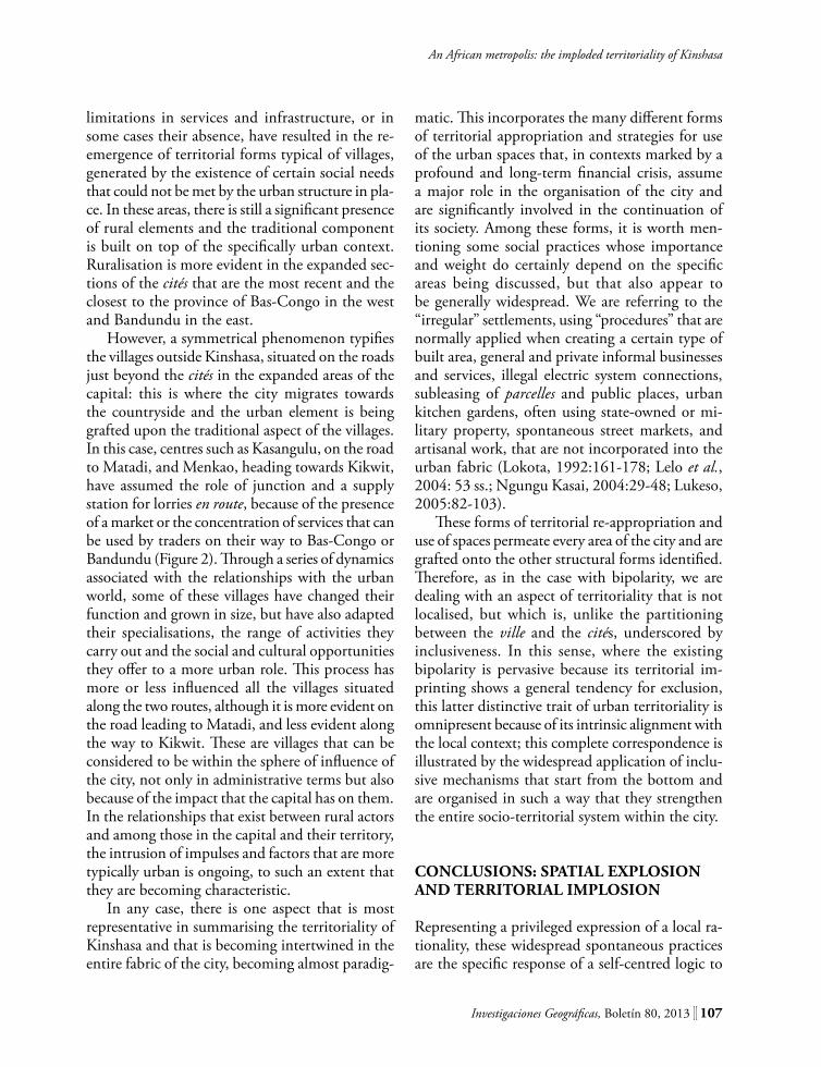
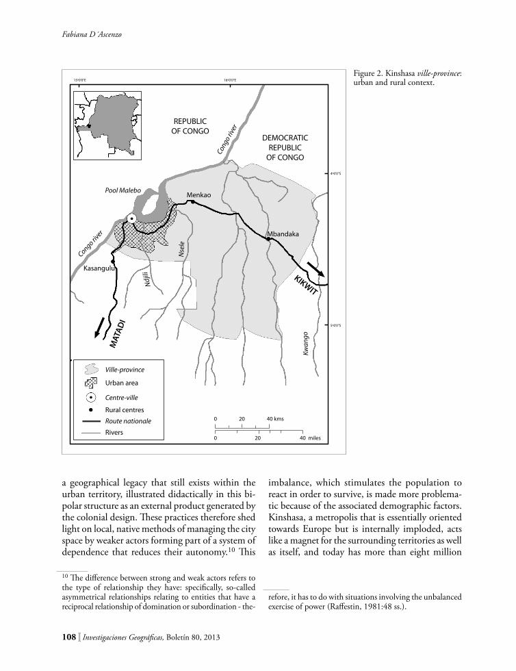
However, a symmetrical phenomenon typifies the villages outside Kinshasa, situated on the roads just beyond the cités in the expanded areas of the capital: this is where the city migrates towards the countryside and the urban element is being grafted upon the traditional aspect of the villages. In this case, centres such as Kasangulu, on the road to Matadi, and Menkao, heading towards Kikwit, have assumed the role of junction and a supply station for lorries en route, because of the presence of a market or the concentration of services that can be used by traders on their way to Bas-Congo or Bandundu (Figure 2). Through a series of dynamics associated with the relationships with the urban world, some of these villages have changed their function and grown in size, but have also adapted their specialisations, the range of activities they carry out and the social and cultural opportunities they offer to a more urban role. This process has more or less influenced all the villages situated along the two routes, although it is more evident on the road leading to Matadi, and less evident along the way to Kikwit. These are villages that can be considered to be within the sphere of influence of the city, not only in administrative terms but also because of the impact that the capital has on them. In the relationships that exist between rural actors and among those in the capital and their territory, the intrusion of impulses and factors that are more typically urban is ongoing, to such an extent that they are becoming characteristic.
In any case, there is one aspect that is most representative in summarising the territoriality of Kinshasa and that is becoming intertwined in the entire fabric of the city, becoming almost paradig-
matic. This incorporates the many different forms of territorial appropriation and strategies for use of the urban spaces that, in contexts marked by a profound and long-term financial crisis, assume a major role in the organisation of the city and are significantly involved in the continuation of its society. Among these forms, it is worth men-tioning some social practices whose importance and weight do certainly depend on the specific areas being discussed, but that also appear to be generally widespread. We are referring to the “irregular” settlements, using “procedures” that are normally applied when creating a certain type of built area, general and private informal businesses and services, illegal electric system connections, subleasing of parcelles and public places, urban kitchen gardens, often using state-owned or mi-litary property, spontaneous street markets, and artisanal work, that are not incorporated into the urban fabric (Lokota, 1992:161-178; Lelo et al., 2004: 53 ss.; Ngungu Kasai, 2004:29-48; Lukeso, 2005:82-103).
These forms of territorial re-appropriation and use of spaces permeate every area of the city and are grafted onto the other structural forms identified. Therefore, as in the case with bipolarity, we are dealing with an aspect of territoriality that is not localised, but which is, unlike the partitioning between the ville and the cités, underscored by inclusiveness. In this sense, where the existing bipolarity is pervasive because its territorial im-printing shows a general tendency for exclusion, this latter distinctive trait of urban territoriality is omnipresent because of its intrinsic alignment with the local context; this complete correspondence is illustrated by the widespread application of inclu-sive mechanisms that start from the bottom and are organised in such a way that they strengthen the entire socio-territorial system within the city.
conclUsIons: sPAtIAl exPlosIon And teRRItoRIAl ImPlosIon
Representing a privileged expression of a local ra-tionality, these widespread spontaneous practices are the specific response of a self-centred logic to
108 ][ Investigaciones Geográficas, Boletín 80, 2013
Fabiana D´Ascenzo
a geographical legacy that still exists within the urban territory, illustrated didactically in this bi-polar structure as an external product generated by the colonial design. These practices therefore shed light on local, native methods of managing the city space by weaker actors forming part of a system of dependence that reduces their autonomy.10 This
10 The difference between strong and weak actors refers to the type of relationship they have: specifically, so-called asymmetrical relationships relating to entities that have a reciprocal relationship of domination or subordination - the-
imbalance, which stimulates the population to react in order to survive, is made more problema-tic because of the associated demographic factors. Kinshasa, a metropolis that is essentially oriented towards Europe but is internally imploded, acts like a magnet for the surrounding territories as well as itself, and today has more than eight million
refore, it has to do with situations involving the unbalanced exercise of power (Raffestin, 1981:48 ss.).
15º0'0"E 16º0'0"E
5º0'0"S
0 20 40 kms
0 20 40 miles
REPUBLICOF CONGO
MATAD
I
Menkao
Mbandaka
Urban area
DEMOCRATICREPUBLIC
OF CONGO
KIKWIT
Kasangulu
Pool Malebo
Congo river
Congo
rive
r
Kwan
go
Nse
le
Ndj
ili
Ville-province
Centre-ville
Rural centres
Route nationale
Rivers
4º0'0"S
Figure 2. Kinshasa ville-province: urban and rural context.

Investigaciones Geográficas, Boletín 80, 2013 ][ 109
An African metropolis: the imploded territoriality of Kinshasa
inhabitants.11 Developed as a city in its modern sense under colonialism, ‘qui à inventé et créé l’image d’un Congo “primitif ” et sa contre-image, le paysage urbain’ (De Boeck and Plissart, 2005:20), the capital is a swarming agglomeration, which expanded in all directions in the 1960s and has not stopped since.
Moreover, the urban implosion of Kinshasa is one of the effects caused by the national territorial structure, which is oriented towards the exterior and dependent on the exterior. Indeed, the lack of adequate relationships has prevented the city from establishing an efficient exchange network with the rest of the country, producing a kind of “urban autism”, with the result that the city has established relationships above all with its own component parts. In addition, within the city itself, the most efficient interactive dynamics are concentrated in a few areas, while the needs of the city are those expressed by millions of inhabitants spread over an extremely vast area, which is constantly expanding. The aspects of urban territoriality discussed here are therefore the result of the social pressure exerted on a territory that was in part inherited and in part redefined, but which, in any case, is inadequate to meet the needs of its citizens.
Because of the prolonged absence of policies capable of reconstructing a new urban order for a changed social construct, the population has continued to make use of the city, adapting itself to whatever the urban space is capable of offering
11 In the absence of updated statistical sources, the question of the urban population in the capital city remains unre-solved. Therefore, given the fact that in Africa, data often show only ranges of figures, we have merely provided the only certain demographical element, specifically that the threshold of eight million has been exceeded. Neverthe-less, it is worth noting that in the Democratic Republic of Congo, about 42% of children under five are not registered at birth and the same thing can be said about the movement of migrants towards the city. Generally, the demographic information about the city changes with different sources, but what matters in this case is that we assume a reliable range of variation, identified as between eight and nine million inhabitants. This does not mean that the reality is not different: for example, in 2009, an issue of the magazine Jeune Afrique indicated that Kinshasa has a population of 9 400 000 inhabitants (Devey, 2009:95).
in terms of location, accessibility, work and services and, at the same time, adapting to society’s own needs through practices and strategies created and reinvented on a daily basis. The explosion of Kinshasa, i.e. the massive use of space that marked the growth of the city after independence, thus corresponded to a territorial implosion. This has led to a complex territoriality, made up of structural geographical features that have, to a varying extent, formed the agglomeration. As we have seen, these aspects of urban territoriality either have a more marked influence on a certain area of the city or indiscriminately affect the metropolis in its entirety. However, they intersect and overlap, manifesting their existence in a way that makes it difficult to tell them apart.
In a given part of the territory, specifically that of the capital city, and the way it has developed up to the present day, it is therefore possible to iden-tify various processes and components: a bipolar structure, the characteristics of a global hub, hybrid functionality, the ruralisation of the urban fabric, the urban encroaching on rural areas, and the widespread introduction into the city of artefacts deriving from spontaneous social practices. Finally, all of these aspects contribute, to a varying extent, to defining an imploded, multifaceted and dense territoriality, which is the overall result of various strategies that, associated with more or less recent history, have remained fixed in the urban context and in its geography.
RefeRences
BEAU (1991), Les villes secondaires. Gestion urbaine, éco-nomie urbaine, équipements, Ministère des Travaux Publics, Aménagement du Territoire, Urbanisme et Habitat, Kinshasa.
BEAU (2003), Rapport-synthèse sur l’accès des populations aux services urbains de base dans la ville de Kinshasa, Ministère des Travaux Publics et Infrastructures, Kinshasa.
Bruneau, J.-C. and Th. Simon (1991), Zaïre. L’espace écar-telée, Ministère des Travaux Publics, Aménagement du Territoire, Urbanisme et Habitat, BEAU, Kinshasa.
110 ][ Investigaciones Geográficas, Boletín 80, 2013
Fabiana D´Ascenzo
Bruneau, J.-C. (1995), “Crise et déclin de la croissance des villes au Zaïre. Une image actualisée”, Revue Belge de Géographie, 119e année, Bruxelles, pp. 103-114.
De Boeck, F. and M. F. Plissart (2005), Kinshasa, récit de la ville invisible, La Renaissance du Livre, Bruxelles.
Delbart, V. (1999-2000), Evolution de l’emprise spatiale de la ville de Kinshasa, Mémoire de licence en sciences géographiques, ULB, Bruxelles.
Delbart, V. and E. Wolff (2002), “Extension urbaine et densité de la population à Kinshasa: contribution de la télédétection satellitaire”, Belgeo, n. 1, Bruxelles, pp. 45-59.
Dematteis, G. (1995), Progetto implicito. Il contributo della geografia umana alle scienze del territorio, Franco Angeli, Milano.
De Maximy, R. (1984), Kinshasa. Ville en suspens. Dy-namique de la croissance et problèmes d’urbanisme. Approche socio-politique, ORSTOM, Paris.
De Saint Moulin, L., 1971, “Les anciens villages des environs de Kinshasa”, in AA. VV., Études d’histoire africaine, tome II, Université Lovanium, Kinshasa, pp. 83-119.
De Saint Moulin, L. (2007), “Croissance de Kinshasa et transformations du réseau urbain de la République Démocratique du Congo depuis l’indépendance”, in J.-L. Vellut (dir.), Villes d’Afriques. Explorations en histoire urbaine, L’Harmattan, Paris.
Devey, M. (2009), “Belle, rebelle…et miraculée”, Jeune Afrique, 26 avril – 9 mai, Paris, pp. 94-96.
Flouriot, J., R. de Maximy and M. Pain (1975), Atlas de Kinshasa, Institut Géographique du Zarïe (IGZ), Bureau d’Études d’Aménagement du territoire, Kinshasa.
Flouriout, J. (1975), “Typologie de l’habitat”, in J. Flou-riot, R. de Maximy, M. Pain, Atlas de Kinshasa, Ins-titut Géographique du Zarïe (IGZ), Bureau d’Études d’Aménagement du territoire, Kinshasa.
Fumunzanza Muketa, J. (2008), Kinshasa d’un quartier à l’autre, L’Harmattan, Paris.
Godard, X. (1985), “Quel modèle de transports collectifs pour les villes africaines? (Cas de Brazzaville et Kins-hasa)”, Politique africaine, n. 17, Paris, pp. 41-57.
Governa, F. (2005), “Sul ruolo attivo della territorialità”, in G. Dematteis, F. Governa (a cura di), Territorialità, sviluppo locale, sostenibilità: il modello SLoT, Franco Angeli, Milano, pp. 39-67.
Kakese Kunyima, C. (2006,) Eléments de géographie humaine et économique, MÉDIASPAUL, Kinshasa.
Lelo Nzuzi, F. and C. Tshimanga Mbuyi (2004), Pauvreté urbaine à Kinshasa, Cordaid, La Haye.
Lelo Nzuzi, F. (2008), Kinshasa. Ville & environnement, L’Harmattan, Paris.
Lokota, E. P. (1992), “L’économie informelle à Kinshasa: fait nouveau ou permanent” Cahier, n. 3-4, série 3, Économie agricolture, Centre d’Étude et de Documen-tation Africaines – CEDAF, Bruxelles, pp. 161-178.
Lukeso, P. (2005), “Et le chômage engendra le «sous-infor-mel» ”, Congo-Afrique, n. 392, Kinshasa, pp. 82-103.
Lumenga-Neso Kiobe, A. (1995), Kinshasa. Genèse et sites historiques, Arnaza-Bief, Kinshasa.
Mwanza wa Mwanza (1995), “Kinshasa: stratégies et limites d’adaptation des transports urbains à la crise”, Revue Belge de Géographie, 119e année, Bruxelles, pp. 123-134.
Mwanza wa Mwanza (1997), Le transport urbain à Kin-shasa. Un nœud gordien, L’Harmattan, Paris.
Ngungu Kasai, D. P. (2004), “Analyse des mécanismes et stratégies de survie de la population de Kinsha-sa: cas des boutiques et ligablos”, in Observatoire d’économie politique et de développement humain, Vivre et survivre à Kinshasa. Problématique du dé-veloppement humain, Université d’Anvers-Facultés Catholiques de Kinshasa, Kinshasa, pp. 11-48.
Pain, M. (1975), “Typologie de l’habitat”, in J. Flouriot, R. de Maximy, M. Pain, Atlas de Kinshasa, IGZ, Kinshasa.
Pain, M. (1984), Kinshasa. La ville et la cité, ORSTOM, Paris.
Pourtier, R. (2003), L’Afrique centrale et les régions trans-frontalières: perspectives de reconstruction et d’intégra-tion, OCDE, Paris.
Raffestin, C. (1981), Per una geografia del potere, Uni-copli, Milano.
Raffestin, C. (2007), “Il concetto di territorialità”, in M. Bertoncin, A. Pase (a cura di), Territorialità. Necessità di regole condivise e nuovi vissuti territoriali, Franco Angeli, Milano, pp. 21-31.
Sassen, S. (2008), Una sociologia della globalizzazione, Einaudi, Torino.
Soja, E. W. (2007), Dopo la metropoli. Per una critica della geografia urbana e regionale, Pàtron, Bologna.
Turco, A. (1988), Verso una teoria geografica della com-plessità, Unicopli, Milano.
Vanthemsche, G. (2005), “Le plan décennal et la moder-nisation du Congo belge (1949-1959)”, in AA.VV., La mémoire du Congo. Le temps colonial, Musée Royal de l’Afrique Central-Èditions Snoeck, Tervuren-Gand, pp. 104-107.
Wolff, E., J.-C. Dhi Mbita Mulenghe, J. Ipalaka Yobwa and M. Massart (2001), Organisation de l’espace et infrastructure urbaine en République Démocratique du Congo, ADIE, Libreville (Gabon).