an annotated bibliography of surface erosion from … annotated bibliography of surface erosion from...
TRANSCRIPT
An Annotated Bibliography of Surface Erosion from Forest Roads
by
Patrick Teti1, Rita Winkler2, Brian Guy3, and Hugh Hamilton3
November 6, 1997
Purpose In 1995, a proposal for a five year research project was submitted to Forest Renewal BC on the subject of surface erosion from logging roads. The plan was to do a Problem Analysis followed by a four year field project. In 1996, one year of funding was received from FRBC to do the Problem Analysis. This bibliography represents part of the work that was done for the Problem Analysis. Funding for this annotated bibliography was also provided by the B.C. Ministry of Forests.
Search Methods and Document Sources This bibliography was compiled from personal collections, selected references identified in computer searches, and card catalogue searches at the Ministry of Forests Research Library and the University of BC. It is divided into two sections. The first section is a manually contructed bibliography which includes the more pertinent references that were found in TreeCD and AGRICOLA The second section consists of the computer search results from TreeCD, AGRICOLA Geobase, and Ei Compendex Plus. Computer search criteria varied slightly between databases due to their different content and included the following:
Surface Erosion Soil Erosion AND (Logging OR Road) Sediment AND Road Erosion AND Road
Annotations to references in Section 1 were made by the individual compilers of this bibliography. These may include the abstract, personal notes, and excerpts as stated. The source of each contribution is indicated by initials at the end of each citation.
1 Ministry of Forests, #200 - 640 Borland St., Williams Lake, B.C. V2G 4T1 2 Ministry of Forests, 515 Columbia St., Kamloops, B.C. V2C 2T7 3 Summit Environmental Consultants Ltd., #17A - 100 Kalamalka Road, Vernon, B.C., V1T 7M3

Nov. 6, 1997
2
Section 1 - Manually Compiled References with Annotations Anderson, Bruce; Potts, Donald F. 1987 Suspended Sediment and Turbidity Following Road Construction and Logging in Western Montana Water Resources Bulletin, Vol. 23, No. 4, pp. 681-690. Abstract Forest management activities in a second-order drainage basin increased suspended sediment yields 7.7 fold in the first year following road construction, and two-fold following logging in the second year. Sediment supply limitations resulted in poor correlations between sediment concentrations with discharge. Sediment transport was strongly hysteretic, with the highest sediment concentrations occurring on the rising limbs of snowmelt hydrographs and individual peaks. In addition to discharge, hydrograph characteristics such as limb, dQ/dt, and the product of dQ/dt and limb aided in explaining variability of observed sediment concentrations. Sediment-turbidity relationships were strongly discharge dependent, reflecting the changing composition of the suspended load with stream power and sediment supplies. Key Words: suspended sediment; sediment transport; turbidity; water quality; sedimentation; watershed management; forest management. (PT) Anderson, Henry W., Marvin D. Hoover, and Kenneth G. Reinhart 1976 Forests and Water: effects of forest management on floods, sedimentation, and water supply USDA For Svc Gen Tech Rpt PSW-18, Berkeley, 115pp. Key Words: FOREST MANAGEMENT HYDROLOGY REVIEW INFILTRATION PEAK FLOW ET EROSION SEDIMENTATION ROADS FIRE GRAZING WETLANDS MINING WATER QUALITY YIELD (PT) Anonymous 1978 Maintenance Considerations for Mainline Logging Roads Journal of Logging Management, 1978 Key Words: road maintenance, road building, road surfaces. Notes: Discusses construction, subgrade, ditches, culverts, and grading in considerable detail with photos. Costs and benefits from a maintenance and engineering point of view are discussed. Erosion control is discussed with respect to protecting the road. (PT) BESCHTA, R.L. 1978 Long-term Patterns of Sediment Production Following Road Construction and Logging in the Oregon Coast Range.

Nov. 6, 1997
3
Water Resources Research 14(6):1011-1016. OREGON, SEDIMENT, IMPACTS OF LOGGING ON EROSION, IMPACTS OF ROADS ON EROSION, IMPACTS OF FIRE ON HYDROLOGY ABSTRACT Suspended sediment production after road construction, logging, and slash disposal was significantly increased (P = 0.95) on two watersheds in Oregon's Coast Range. A 25% patch-cut watershed showed increases during 3 of 8 posttreatment years. These increases were caused primarily by mass soil erosion from roads. Monthly sediment concentrations before the occurrence of annual peak flow were increased more than those following the annual peak. Surface erosion from a severe slash burn was the primary cause of increased sediment yields for 5 posttreatment yields on a watershed that was 82% clearcut. Monthly sediment concentrations were generally increased throughout the winter runoff period on this watershed. The flushing of suspended sediment in Oregon Coast Range watersheds is apparent from seasonal changes of suspended sediment rating curves. (RW) Bilby, Robert E. 1985 Contributions of Road Surface Sediment to a Western Washington Stream Forest Sci., Vol. 31, No. 4, 1985, pp. 827-838 Abstract This study examined the input of sediment from a gravel-surfaced road to a small western Washington stream to determine to what extent this material deposited on the streambed or intruded into the gravels used by salmonids for spawning. Sediment deposition occurred only during periods of low flow and was flushed from the system with even modest increases in stream discharge. There was no significant difference in the level of fine sediment (<2 mm) in gravels above and below the input point. The predominant reason for the lack of deposition or intrusion of this material was the small size of the road sediment, 80 per cent, by weight, being finer than 0.004 mm. Less than 10 per cent of the fine sediment in the streambed was finer than 0.062 mm. The size of the material delivered to the stream was likely limited by the gentle gradient of and vegetation in the roadside ditches. Forest Sci.: 827-838 Key Words: Sediment intrusion, spawning gravel, sediment transport. (PT) Bilby, Robert E.; Sullivan, Kathleen; Duncan, Stanley H. 1989 The Generation and Fate of Road-Surface Sediment in Forested Watersheds in Southwestern Washington Forest Science, Vol. 35, No. 2, pp. 453-468. Abstract Studies conducted in southwestern Washington, examining the generation of sediment on gravel road surfaces, its transport to small streams and its fate after entering flowing waters, are reviewed. The amount of sediment produced on an hourly basis from a road segment was related to traffic rate. Accumulated material flushed rapidly from the road surface with precipitation, leading to a decrease in sediment concentration in the ditch with time during a storm. Depth of road ballast and type of surfacing material also influenced sediment generation. The majority of
Nov. 6, 1997
4
the sediment produced by these roads was finer than 0.004 mm. Steeper roads produced a higher proportion of coarser particles. Approximately 34% of surveyed road drainage points entered streams, mainly first- and second-order channels. Thus, the deliver of road sediment to larger streams often depended on its transport through these smaller channels. Small streams temporarily retained a high proportion of road sediment input to them. Coarser particles were retained at a higher rate than finer material. Due to the fine particle size of road sediment delivered to streams, little effect of this material on the composition of streambed gravel could be discerned. The results of these studies provide guidelines for management of those roads where sediment has the highest potential to impact aquatic resources. Key Words: Erosion, sediment transport, stream gravel, logging effects on streams. (PT) Bovis, M.J. 1993. Hillslope geomorphology and geotechnique. Progress Phys. Geogr. 17:173-189. Notes: A review paper on recent Canadian contributions to hillslope geomorphology, emphasizing geotechnical studies of mass movement phenomena in the Canadian Cordillera. Provides important context for forest road erosion studies in B.C. (SECL) Bradley, A.H 1993 Testing a Central Tire Inflation system in Western Canadian Log-Hauling Conditions Forest Engineering Research Institute of Canada (FERIC), Technical Note No. TN-197. Abstract This report describes a field trial of a central tire inflation (CTI) system installed on the drive tires of a log truck operating in the Interior of British Columbia. The trial was conducted in 1990 and 1991 by the Forest Engineering Research Institute of Canada (FERIC) and other cooperators. The objectives were to demonstrate CTI technology to the Canadian forestry community, to test the performance and reliability of a CTI system under Western Canadian log-hauling conditions, to measure tractive improvements offered by a CTI system, and quantify any changes in drive tire and mechanical maintenance associated with using CTI. Key Words: road transportation, logging trucks, tires, central tire inflation system, performance, evaluation. (PT) Bradley, Allan H. 1995 Lower tire pressures lessen sedimentation from forest roads Forest Engineering Research Institute Field Note No: Loading & Trucking-47, 2p. Notes: Three year study in Oregon indicated that reducing tire pressure on logging trucks reduced erosion by distributing load over a larger surface which reduces the depth of rutting in the running surface. Erosion was reduced by 45 percent with constant reduced pressure on loaded and unloaded trucks and by 80 percent by varying tire pressure with varying load using a central tire inflation system. (PT)

Nov. 6, 1997
5
Bradley, Allan H. 1996 Trial of a Central Tire Inflation System on Thawing Forest Roads Forest Engineering Research Institute of Canada (FERIC), Technical Report No. TR-116 Abstract Many forest companies in Canada are subject to operational restrictions when spring thaw conditions make their roads impassable. Recent trials by the Forest Engineering Research Institute of Canada using chip trucks equipped with central tire inflation systems have shown that transport over thawing roads may be feasible using reduced tire pressures. This report describes the results of three trials with variable tire pressures: two trials on thawing forest roads, and one evaluation of stress and strain in stiff pavements. Key Words: road transportation, chip transportation, logging trucks, chip trucks, tires, central tire inflation system, roads, forest roads, thawing roads, performance, evaluation, Alberta (PT) Brown, George W. and James T. Krygier 1971� Clear-Cut Logging and Sediment Production in the Oregon Coast Range WRR 7(5):1189-1198 Key Words: LOGGING EROSION SEDIMENT NOTES: Sediment production doubled after road construction only in one watershed. It tripled after clearcutting and burning in another. (PT) Brownlee, M.J., B.G. Shepherd, and D.R. Bustard 1988 SOME EFFECTS OF FOREST HARVESTING ON WATER QUALITY IN THE SLIM CREEK WATERSHED IN THE CENTRAL INTERIOR OF BRITISH COLUMBIA Canadian Technical Report of Fisheries and Aquatic Science 1613: 41p. ABSTRACT The effects of forest harvesting practices on water quality were examined within a watershed 80 km east of Prlnce George in the central interior of Brltlsh Columbia between 1971 and 1975. Suspended sediment loading in the study stream, Centenial Creek, increased 4 to 12 times over corresponding levels in an adjacent control stream. Mainline road development was the main source of increased levels of sediment which persisted for the duration of the three years of study. At associated tributaries, erosion from skid trails, landings, road crossings and streambank damage occurred during and after logging, but in contrast, it did not persist beyond the first summer after logging. Mean water temperatures increased 1 to 3 C following logging to the edge of small tributary streams. Diurnal fluctuations more than doubled. Although maximum water temperatures in these small streams increased up to 9 C they remained within tolerance levels for salmonids. When instream nutrients were at high levels, logged areas had 1-2 times the orthophosphate concentrations, 2-3 times the total phosphate concentrations, and up to 5 times the nitrate concentrations present in the unlogged watershed. The implications of this study's results to forest harvesting operations in the interior of Brltlsh Columbia are discussed. (PT)
Nov. 6, 1997
6
Brynn, D.J. and J.C. Clausen. 1991. Postharvest assessment of Vermont's acceptable silvicultural management practices and water quality impacts. North. J. Appl. Forestry. 8:140-144. (SECL) BURROUGHS, E.R. Undated Predicting Onsite Sediment Yield From Forest Roads. Reference unknown (p. 223-232) BRITISH COLUMBIA, SEDIMENT, IMPACTS OF ROADS AND LOGGING ON EROSION, RUNOFF ABSTRACT A continuing Forest Service research effort to study onsite sediment yield from forest lands provides information on the relative erodibility of certain geologic parent materials and methods to reduce surface erosion. Simulated rainfall on bounded plots is the principal research tool to generate runoff and sediment from selected sites. This technique is also used to measure the reduction in sediment yield as a percentage of that from an unprotected site. Two types of disturbed forest sites are being studied: forest roads and timber harvest areas. Graphs are provided to estimate the amount of erosion reduction by selected treatments on road cutslopes and fillslopes. Percentage ground cover is the principal variable to reduce surface erosion. Where data are available, graphs show estimations of the application rate necessary to provide the required amount of ground cover for a selected percentage erosion reduction. For some treatments, erosion reduction is also a function of slope gradient and silt content in the surface soil. In these cases, an erosion reduction treatment is less effective for steeper slopes and siltier soils. The net result of controlling erosion on the various components of the forest road is not the sum, or product, of the percentage erosion reduction for each component. Research results are used to partition sediment yield from a 100- foot road section consisting of a running surface, ditch, and cutslope. This partitioning shows the expected decrease in sediment yield as each component of the road is protected, taking into account the contribution from the other components. A procedure is presented to design a rock blanket for the road ditch as a function of the expected discharge, slope, and ditch shape. (RW) Burroughs, Edward R., Jr.; King, John G. 1989 Reduction of Soil Erosion on Forest Roads USDA Forest Service General Technical Report INT-264 Abstract Results of on-site erosion control work from across the United States provide estimates of the amount of erosion reduction on forest roads from various treatments. Supplementary information includes the effects of slope gradient, soil characteristics, and ground cover. Estimates of sediment travel below fillslopes can be made, together with the combined effect of erosion control treatments of the running surface, road cut, and ditch. Key Words: Erosion control, erosion reduction, estimating sediment transport. (PT)

Nov. 6, 1997
7
Burroughs, Edward R., Jr. 1991 FOREST SERVICE ENGINEERING RESEARCH TO DEVELOP A MODEL OF ONSITE SEDIMENT PRODUCTION FROM FOREST ROADS AND TIMBER HARVEST AREAS pp. 151-160 in Proc. Forestry and Environment - Engineering Solutions, Am. Soc. Agric. Eng., 1991, New Orleans, LA Author: Research Engineer, Intermountain Research Station, USDAFS, Forestry Sciences Laboratory, Moscow, Idaho. (scanned) Forest land management activities in the United States have extended and accelerated in the past four decades into steep, mountainous lands, and into more economically and environmentally marginal operating situations. Also, increasing environmental awareness over the last 25 years has focused considerable attention on the potential impacts of any forest-based activity upon the environment. Of particular concern is soil loss leading to reduction of future forest productive capacity, water quality degradation, damage to aquatic ecosystems, and visual degradation. In many parts of the nation, particularly the Pacific Northwest, forest land managers have found that their management alternatives are constrained by limits on turbidity and sediment concentration allowed in receiving streams. It is essential that managers have the means to predict, with acceptable accuracy, sediment production from alternative road construction and maintenance plans and alternative harvest area treatment practices (Burroughs et al. 1991). ... In 1986, the U.S. Department of Agriculture, Agricultural Research Service, initiated the Water Erosion Prediction Project (WEPP) for use on croplands and rangelands to replace the Universal Soil Loss Equation. The Forest Service joined the WEPP effort because of our interest in estimating sediment production from disturbed forest lands. The WEPP model cannot be used in its present form on forest sites because of the many hydrologic and erosion conditions that are not considered in the cropland WEPP model. The goal of our work is to develop physical process models of onsite runoff and sediment production for use on forest roads and timber harvest areas nationwide. To do this, we must develop algorithms to estimate model parameters using easily measured site characteristics from field sites across the nation. This "forest model" will become an integral part of the general WEPP model. Observations and experience by forest land managers and technical specialists nationwide indicate that forest roads are the greatest single source of sediment delivered to receiving streams. Probably the greatest volume of sediment produced from Alaska to California and the northern and central Rocky Mountains comes from mass erosion associated with forest road construction and maintenance. A lesser volume comes from surface erosion on the forest road prism, and a much smaller volume from landslides and surface erosion on timber harvest areas. Fall and winter rains, and spring snowmelt runoff in the west, provide ample energy for surface erosion. (PT) Burroughs, Edward R., Jr., Foltz, Randy B.; Robichaud, Peter F. 1991.

Nov. 6, 1997
8
United States Forest Service research on sediment production from forest roads and timber harvest ereas. In: Actes Proceedings Actes 2: 10th World Forestry Congress; 1991 September 18-22; Paris, France. Rev. For. Francaise 2. Rome, Italy: Food and Agricultural Organization of the United Nations: 187-193. SUMMARY The United States Forest Service is developing a surface erosion model for disturbed forest sites, principally forest roads and timber harvest areas. Simulated rainfall is used on bounded plots of various sizes to generate runoff and sediment production from a wide range of soil textures and land management situations. The usual sequence of rainfall at a selected intensity is a 30-minute application with the soil in a dry condition, followed 24-hours later by a second application, then followed as soon as possible by a third. Two rainfall intensities are used on forest roads: 25 mm/hr and 51 mm/hr. Several rainfall intensities are used on timber harvest sites, ranging from 51 mm/hr to 102 mm/hr. Data from simulated rainfall on small field plots, burned and unburned, with and without the residual root mat removed, showed the increases in sediment yield to be expected from severe slash treatment/site preparation burns. Field plots on timber harvest areas that were unburned and burned with and without machine compaction provided data on the effects of these treatments under natural rainfall conditions. Results of a laboratory study of the hydraulic roughness of overland sheet flow with rainfall and a field study of the hydraulics of concentrated flow in wheel ruts were used in an analytic model of runoff from forest roads. Data from a laboratory study of the relative erodibility of wildland soils were used to estimate interrill sediment detachment as a function of soil texture and clay mineralogy. Simulated rainfall on bounded road plots up to 38 m long showed that wheel ruts increased sediment production by a factor of two to four over similar unrutted road sections. The difference in the increase was a function of relative soil erodibility. (PT) BUTT, G. 1988 Hydraulic Creek Erosion Study. Unpub. Rep. for B.C. Min. of Forests, Penticton Forest District. 23 pp. BRITISH COLUMBIA INTERIOR, HYDRAULIC CREEK, EROSION, IMPACTS OF LOGGING ON EROSION, SEDIMENT EXECUTIVE SUMMARY This report accompanies a 1:10,000 scale map identifying areas of low, moderate, and high erosion hazard within the Hydraulic Creek watershed. Erosion hazard is defined as the probability that sediment production will occur and that sediment so produced will be delivered to the stream system. In general, soil and terrain in Hydraulic Creek are such that erosion hazard is low. The highest erosion hazards are associated with an area of silty, lake-bed sediments now under agricultural use, and sloping morainal soils which drain directly into a sensitive reach of Hydraulic Creek. Past logging practices have led to some sediment production. Road surfaces appear to have been the most significant sediment source. Improved cross- drainage and selected retirement of older roads is recommended. Research findings in the Pacific Northwest suggest that suspended sediment increases during road construction, then declines after disuse. Therefore extra care is required for any new

Nov. 6, 1997
9
logging in Hydraulic Creek. Judicious road planning to minimize total road length and the number of stream crossings is necessary, together with aggressive retirement of access roads. It is essential to pay special attention to streamside environments, including draws and ephemeral streams which may appear dry at the time of logging. Close supervision and/or explicit instructions for machine operators is required. Hydraulic Creek is an example of a sensitive resource conflict, with pressure for continued clearcutting on the one hand, and demands for high water standards on the other. Water users have a right to expect exacting levels of watershed management. Forest companies must be prepared to invest greater than average time and effort to minimize sediment delivery. If they are willing to make that investment, then continued clearcutting should be possible. (PT) CARR, W.W. 1980 A Handbook for Forest Roadside Erosion Control in British Columbia. B.C. Min. of For., Land Manage. Rep. No. 43 pp. BRITISH COLUMBIA, EROSION, REVEGETATION, IMPACTS OF ROADS ON EROSION PURPOSE This handbook is primarily concerned with the establishment of vegetation on forest road construction sites that present a problem with surface erosion and sediment production. The soil and surficial materials exposed by road construction are inherently infertile and low in organic matter. Such areas can be transformed to a state of stable productivity by appropriate measures. It is obvious that a construction scar covered with vegetation is more pleasing visually than one that is actively eroding or gullied. Although this handbook does not specifically deal with aesthetics, it is a factor to be considered which should not interfere with functional protection of the soil surface. The materials and methods discussed in this handbook are aimed for use in the British Columbia forest environment. Physical, climatic, and economic parameters peculiar to British Columbia govern much of what is contained in this handbook. A more general reference for erosion control procedures, from which much of this handbook has been adapted, is: Methods of Quickly Vegetating Soil of Low Productivity, Construction Activities, EPA-440/9-75-006, July 1975, U.S. E.P.A. (RW) CARR, W.W. 1985 Watershed Rehabilitation Options for Disturbed Slopes on the Queen Charlotte Islands. B.C. Min. of Forests Land Manage. Rep. No. 36, 34 pp. BRITISH COLUMBIA COAST, EROSION, LANDSLIDES, WATERSHED MANAGEMENT, IMPACTS OF LOGGING ON EROSION, IMPACTS OF LOGGING ON LANDSLIDING, IMPACTS OF ROADS ON EROSION, IMPACTS OF ROADS ON LANDSLIDING ABSTRACT Surface erosion and mass wasting in forested watersheds can increase significantly following road development and logging. This is particularly true on steep forested slopes that receive a great deal of precipitation, such as those on the Queen Charlotte Islands. Through proper

Nov. 6, 1997
10
planning and the use of high construction standards, many of these problems can be alleviated, but not completely controlled. In addition, unforeseen problems that result in accelerated surface erosion and mass wasting may arise. For these reasons, the forest manager must have a variety of measures to either control erosion or lessen its impacts. This report reviews both prevention and rehabilitation techniques that may be of use in controlling erosion and/or alleviating further erosion damage on the Queen Charlotte Islands. To date, little erosion control or land rehabilitation work has been carried out on forested land on the Charlottes, and it is hoped that this report may provide the basis for future activities in this field. (RW) Cederholm, C.J., L.M. Reid, and E.O. Salo Year unknown Cumulative Effects of Logging Road Sediment on Salmonid Populations in the Clearwater River, Jefferson County, Washington� pp. 38- in Salmon-Spawning Gravel: A Renewable Resource in the Pacific Northwest? Wat Res Ctr, Wash State Univ, Pullman Key Words: FISH HABITAT SPAWNING LOGGING ROADS SEDIMENT� (PT) Cederholm, C.J. and E.O. Salo 1979 The Effects of Logging Road Landslide Siltation on the Salmon and Trout Spawning Gravels of Stequaleho Creed and the Clearwater River Basin, Jefferson County, Washington, 1972-1978 U of Wash Fish Res Inst FRI-UW-7915, 99 p. Key Words: LOGGING FISH HABITAT SPAWNING SEDIMENT ROADS Notes: Percent of fines <.85mm increased from about 6 to 18 when % of basin area with roads increased from 0 to 6%. Effects of and retention time of fines, use of substrate for cover. Different categories of road standards (logger choice, management standard, main haul road). Two road related slides deposited approx 20000 cu. yd. of sediment and debris in 1971. (PT) CHAMBERLIN, T.W., R.D. HARR, AND F.H. EVEREST 1991 Timber Harvesting, Silviculture, and Watershed Processes. In Influences of Forest and Rangeland Management on Salmonid Fishes and their Habitats. American Fisheries Society Special Publication 19, Chap. 6. p.181-205. NORTH AMERICA WESTERN, STREAMFLOW, WATER QUALITY, STREAM TEMPERATURE, EROSION, FISH, HABITAT, IMPACTS OF ROADS, LOGGING, AND FOREST PRACTICES ON FISHERIES (RW) Chatwin, S.C., D.E. Howes, J.W. Schwab, and D.N. Swanston 1991 A Guide for Management of Landslide-Prone Terrain in the Pacific Northwest
Nov. 6, 1997
11
B.C. Ministry of Forests Land management handbook no. 18, 212p. Key Words: Slope stability, geomorphology, field techniques, hazard assessment, Timber harvest planning, Logging roads, erosion, slope stabilization, rehabilitation reclamation deactivation, vegetation, mulch, seed mix. (PT) CHENG, J.D. 1977 The Effects of Logging on the Hydrology of the Coquitlam River Watershed. B.C. Min. of Envir. Water Investigations Branch. 35 pp. BRITISH COLUMBIA COAST, COQUITLAM RIVER, CLEARCUTTING, WATER YIELD, LOW FLOW, PEAK FLOW, SEDIMENT, IMPACTS OF LOGGING ON HYDROLOGY, IMPACTS OF ROADS ON HYDROLOGY ABSTRACT This report discusses the influence of forest and logging operations on the hydrology of Coquitlam River watershed. By considering the nature and quality of logging activities in the watershed and extrapolating published research results from other watersheds, probable changes in watershed hydrology are evaluated. For small, tributary watersheds, clearcut logging as presently practiced in the study area may significantly increase annual water yield, summer low flows and peak flows of low to medium magnitude. However, if logging roads and other severely compacted areas occupy more than 10 percent of the watershed, an increase of 25 percent or more in peak high flows can be expected. This increase would result in possible on-site damage to stream channels and hydraulic structures. Such on-site damage may be even more severe if clearcut logging of unstable slopes causes increases in soil erosion and mass soil movement, which subsequently contribute to increased sediment productions in the streams. Increased sediment production from soil erosion and mass soil movement may also occur if roads are poorly located, constructed and maintained as observed in logged areas of the Or watershed. With less than one percent of the Coquitlam Lake and Or Creek watersheds being logged annually and with rapid revegetation, changes in streamflow on the logged areas will have little effect on the overall watershed runoff patterns. Any increase in peak flow from logged areas may also be overshadowed by such hydrolic events as the failure of temporary debris dams in the streams which release large quantities of water and debris. Furthermore, Coquitlam Lake with its large flow regulation capacity makes any attempt to change water yield and flow regime through forest removal in its watershed undesirable. It is suggested that the primary watershed management objective in the Coquitlam Conservation reserve area is to protect, and where necessary, restore the basic watershed function of supplying abundant water at an acceptable quality. Based on this premise, modifications to logging practices that will minimize detrimental influences on watershed hydrology and soil stability are recommended. (RW) CLINE, R., COLE, G, MEGAHAN, W., PATTEN, R., AND J. POTYONDY 1981 Guide for Predicting Sediment Yields from Forested Watersheds. U.S.D.A. For. Serv., North. and Intermtn. For. and Range Exp. Sta., 47 pp. Report number unknown.

Nov. 6, 1997
12
SEDIMENT, IMPACTS OF ROADS FIRE LOGGING ON EROSION EXECUTIVE SUMMARY A sediment yield prediction procedure has been developed by a work group composed of soil scientists, hydrologists, and watershed specialists of the Northern Region, Intermountain Region, and the Intermountain Forest and Range Experiment Station. The procedure is applicable to the Northern and Intermountain Region's forested watersheds. The procedure was developed principally for watersheds in or generally associated with the Idaho Bathholith but the process described has the capability of adaption to other forested areas. Extrapolation of the numbers given in theis guide to areas outside of the Idaho Batholith should be done with extreme care. The model is applied on watersheds that are stratified using land systems inventory map units. The model produces quantified estimates of sediment yields prior to any management (natural sediment yield) and sediment yields in response to various management scenarios for any number of years. The types of management activities modeled are roading, logging, and fire. The model estimates on-site erosion according to general land unit characteristics, delivers the eroded material to the stream system, and routes it through the watershed to a critical stream reach where interpretations ar made and where monitoring for achievement of planning objectives should take place. The model simplifies, for analysis, and extremely complex system and is developed from a limited data base and scientific knowledge pool. Although it produces specific quantitative values for sediment yield, the results should be treated as rather broad estimates of how real systems may respond. The validity of this model is best when the results are used to compare alternatives, not for predicting specific quantities of sediment yielded. Values produced by this procedure are probably valid for comparisons only where large differences among alternatives are produced. The model is a conceptual framework which outlines a process and is designed to be supplemented by local data and adapted by individual Forests to better reflect local conditions and observations. As a state-of-the-art effort to predict sediment yield, the procedure will undoubtedly receive close scrutiny. In most instances, better and more precise information and techniques applicable to the level of forest management, as practiced today, are simply not available at this time. Consequently, the procedure will undergo continual change and revision. As more information becomes available from studies such as the Silver and Horse Creek studies, this guide will be revised to incorporate any new data and information. The authors recognize that every model is subject to misuse. Many models are probably misused because in many cases more appropriate models are not available. Users are often forced to use models outside the range of conditions considered during development simply because the user must have an answer. For this reason, the limitations and assumptions about the model are clearly documented. Users are encouraged to use their technical expertise considerable professional judgement to assure that reasonable use is made of this model. Models are simply tools to assist in decision making, and users ought to test models against their best technical judgement of what can be logically expected to actually occur on the ground. (RW) Coker, R.J. et al. 1993. Fine sediment production from truck traffic, Queen Charlotte Forest, Marlborough Sounds, New Zealand. J. Hydrology (New Zealand). 31:56-64. (SECL)

Nov. 6, 1997
13
Commandeur, P.R. 1991. Soil infiltration and erosion studies using rainfall simulation. Paper presented at the BC Soil Science Workshop, Vancouver, 1991. Forestry Canada, Victoria. 5 pp. Notes: Rainfall simulation experiments were conducted to evaluate runoff and erosion from skid roads, fire guard surfaces, and an intensively slash-burned site. The portable rainfall simulator provided an efficient means to compare runoff and erosion potential for a range of surfaces (Note see Section 7.0 for additional information on rainfall simulation). (SECL) Commandeur, P.R., B.T. Guy and H. Hamilton. 1995. The role of woody debris in the routing of sediment through small coastal stream channels. Canadian Forest Service, Pacific and Yukon Region. Information Report (in preparation). Notes: Sediment budgets for two small streams were estimated: a control with coarse woody debris in place, and a treatment stream with all CWD removed. Both streams were crossed by three logging roads. Instrumentation included sediment traps on the road cut-slopes and road surfaces, and downstream sediment boxes. (SECL) Commandeur, P.R. and M.E. Walmsley 1993 Impacts of biomass harvesting on soil disturbance and surface soil erosion at Seller Creek in interior British Columbia Forestry Canada Pacific and Yukon Region Information Report BC-X-342, 16 p. Abstract Numerous studies have documented the soil disturbance effects of ground-based harvesting systems. Biomass harvesting, in the form of the additional recovery of woody materials normally left on site, has the potential for increasing the levels of soil disturbance. The objective of this study was to document the impact of biomass harvesting by rubbertired skidders on soils, namely soil disturbance and surface soil erosion. An increase in soil disturbance in the form of skid trails, skidroads, and deep and very deep gouges was observed on the biomass harvested plots compared to the conventionally harvested plots. Erosion bridges indicated more soil movement on the biomass than the conventional plots. Soil erosion volumes trapped behind sediment dams located at the base of the plots were greater on the biomass plots (average of 0.38 m3 over 1.77 years) than on the conventional plots (average of 0.22 m3). However, the unharvested plots also recorded accumulation of material where in fact no mineral soil erosion occurred (average of 0.15 m3). This was the result of vegetation growth and decay and the accumulation of organic matter. Adjusted average erosion values of 0.78 m3/ha/year for the biomass plots and 0.37 m3/ha/year for the conventional plots are comparable to data obtained from studies conducted on clearcut and burned sites in the Oregon Cascades. These erosion figures are considered moderate and numerous site factors help explain this observed response. Rainfall simulation experiments conducted at the site indicated that infiltration rates on skidroads and fireguards are generally greater than 1.5 cm/hour. Rainfall intensities (15 minute duration) that exceed 1.5 cm/hour are expected to occur with a return period of about I year at the study site. Spring snow melt rates may exceed infiltration capacities especially along compacted, low infiltration areas such as skidroads. Some overland flow and surface soil
Nov. 6, 1997
14
erosion is expected to occur elsewhere under similar conditions as those found at the study site. Recommendations are given regarding the measurement techniques used in this study. (PT) Cornish, P.M. 1989. Water quality in unlogged and logged eucalypt forests near Bega, NSW, during a nine-year period. Australian Forestry. 52:276-285. (SECL) Douglas, I. et al. 1993. Impact of roads and compacted ground on post-logging sediment yield in a small drainage basin, Sabah, Malaysia. CSIRO Water Resources Series. 12: 213-218. (SECL) Duncan, S.H. amd J.W. Ward. 1985. The influence of watershed geology and forest roads on the composition of salmon spawning gravel. Northwest Science. 59:204-212. (SECL) Eaton, R. A.; Gerard, S.; Cate, D.W. 1987 Rating Unsurfaced Roads: A field manual for measuring maintenance problems US Army Corps of Engineers. Special Report 87-15. 1987. Key Words: road maintenance, road conditions, dust, potholes, corrugation, washboarding, ruts, road surfaces. (PT) Fahey, B.D.; Coker, R.J. 1988 Erosion and Sediment Production from Forest Roads in Southwest Nelson What's New in Forest Research, Forest Research Inst., No. 186, 1988 Summary Sediment production on freshly graded sections of forest roads formed in granite in Golden Downs and Motueka Forests is around 1.5 km/m2 from the combined road-cutbank surface per year. Yields are higher on steeper segments of road, but the sites studied are representative of average road dimensions and conditions in the two forests. Previous work showed the average annual yield from fresh sidecast fill to be 2 kg/m2. Based on these figures, and the existing road network and area of sidecast fill, a maximum of 13 000 tonnes of sediment could be released each year from the 12 500 ha of forest underlain by granite; actual amounts are expected to be less. Not all of this material will find its way immediately into local streams, but even if it did, it would not be a major contribution when compared with natural sediment yields. The results of this work will be incorporated into a general erosion model which will assist in predicting increases in sediment yield from road sources when existing road networks are expanded and up-graded before forests are harvested. (PT) Fahey, B.D. and R.J. Coker. 1989. Forest road erosion in the granite terrain of southwest Nelson, New Zealand. J. Hydrology (New Zealand). 28:123-141. (SECL)

Nov. 6, 1997
15
Foltz, Randy B. 1994 Reducing Tire Pressure Reduces Sediment USDA Forest Service Technology and Development Program Tech Tips, 1p. (PT) Foltz, Randy B.; Burroughs, Edward R., Jr 1991 A Test of Normal Tire Pressure and Reduced Tire Pressure on Forest Roads: Sedimentation Effects American Society of Agricultural Engineers Pub. 09-91, Proceedings of the 1991 Conference, Forestry an Environment, Engineering Solutions, New Orleans, LA, June 5-6, 1991. Abstract Two 30-m forest road sections were bladed and used to measure sediment yield from a 31,300 kg GVW logging truck using normal (655 kPa) tire pressure on one section and reduced (483 kPa for steering axle and 345 kPa elsewhere) tire pressure on the other. Each insloped road treatment area was divided lengthwise into two plots 30 m long by 1.74 m wide to define one wheel track. Three simulated rainstorms at a rate of 50 mm/hour for 30-minutes each were applied to each plot before truck travel, and three more were applied after truck travel. The tire pressure ranged from 1.07 times (dry run) to 2.20 times (wet run) for the three rainfall applications, with an average value of 1.60. The similar ratio for sediment concentration ranged from 1.31 times (dry run ) to 2.31 times (very wet run) for the three rainfall applications, with an average value of 1.71. These increases in sediment yield and sediment concentration were caused by more concentrated flow, with more erosive power, in the deeper ruts formed in the normal tire pressure treatment area. Soil moisture contents for three of the four plots were greater than the optimum for compaction, but the higher ground pressures on the normal tire pressure treatment area caused deeper rutting while the road surface of the reduced tire pressure treatment area had only minor ruts. These tests clearly indicate that the use of reduced tire pressure has a significant potential to reduce adverse impacts on water quality. Key Words: (PT) Foltz, Randy B. Sediment reduction from the Use of Lowered Tire Pressures pp 47-52 in ? Abstract The use of lowered tire pressures has the capability to reduce sediment production from unpaved forest roads. A three year test of Central Tire Inflation System (CTIS) and Constant Reduced Pressure (CRP) methods to achieve lowered tire pressures was conducted by the US forest Service. The average sediment reduction from the use of CTIS was 80% compared to highway tire pressures. When using CRP tire pressures, the average sediment reduction was 45% compared to highway tire pressures. Both lowered tire pressures systems had shallower, less well defined wheel ruts resulting in less frequent road maintenance requirements. (PT)
Nov. 6, 1997
16
Foltz, Randy B; Truebe, Mark A. Effect of Aggregate Quality on Sediment Production from a Forest Road Sixth International Conference on Low-Volume Roads, pp. 49-57. Abstract Aggregate is placed on forest roads in wet climates to provide structural support for traffic and in dry climates to reduce sediment production caused by precipitation. I both climates aggregate of suitable quality is often not readily available. The substitution of poorer-quality aggregate can cause greater amounts of sediment than those produced by good-quality aggregate. To measure the differences in sedimentation rates, the Forest Service of the USDA conducted a sediment study using two aggregate qualities. The study was conducted using natural rainfall and logging truck traffic on an aggregate-surfaced road during the winters of 1992 and 1993 in western Oregon and using simulated rainfall following the winter of 1993. The results shows that the quality of the aggregate made a notable difference in sediment production. When subjected to heavy logging truck traffic, a marginal-quality aggregate produced from 2.9 to 12.8 times as much sediment as that from a similar section surfaced with good-quality aggregate. The greater difference occurred in the winter with the greater rainfall. Whereas the good-quality aggregate provided the expected level of sediment mitigation, the marginal-quality aggregate did not. These results have important implications for road use and sediment production. (PT) Geppert, Rollin R., Charles W. Lorenz, and Arthur G. Larson 1984 Cumulative Effects of Forest Practices on the Environment, A State of the Knowledge Ecosystems, Inc., Olympia Wash. 208pp. + app. Key Words: REVIEW CUMULATIVE EFFECTS LOGGING Notes: roads, erosion, water quality, peak flows, low flows, fish habitat (PT) GRANT, G.E., CROZIER, M.J., AND F.J. SWANSON 1984 An Approach to Evaluating Off-Site Effects of Timber Harvest Activities on Channel Morphology. Presented at the Symposium on the Effects of Forest Land Use on Erosion and Slope Stability, May 7-11, 1984, Honolulu, Hawaii. p. 177-186 OREGON, STREAM CHANNEL MORPHOLOGY, IMPACTS OF LOGGING ON STREAM CHARACTERISTICS ABSTRACT We present a methodology and develop a new quantitative, aerial photograph interpretation technique for assessing channel response to various off-site effects associated with timber harvest activities. The degree of channel enlargement, associated with a 100 year storm event in the Oregon Western Cascades, is strongly related to upstream logging activities. The nature of the response relates to the mechanism by which sediment and water are introduced to the stream. Of the five types of initiation site (axial landslide, riparian landslide, forest growth, clearcut, and road) for channel enlargement, axial landslides were overwhelmingly important in their occurrence and influence. (RW)

Nov. 6, 1997
17
Grant, G.E. and A.L. Wolff 1991 LONG-TERM PATTERNS OF SEDIMENT TRANSPORT AFTER TIMBER HARVEST, WESTERN CASCADE MOUNTAINS, OREGON, USA USDA Forest Service pacific Northwest Research Station, 3200 Jefferson Way, Corvallis OR. 97331, USA pp. 31-40 in Sediment and Stream Water Quality in a Changing Environment: Trends and Explanation, Proc. of the Vienna Sym., August 1991 IAHS Publ. no. 203 ABSTRACT (scanned) Suspended and bedload sediments were sampled from 1958-1988 on three small watersheds in the western Cascade Range in Oregon. Annual sediment yields varied greatly among watersheds, and the pattern of long- term sediment production reflects their timber harvest and mass movement histories. Total yields from 1958-1988 were 5100 t/sq.km. in the clcarcul watershed (WS 1), 21000 t/sq.km. in the patchcut watershed with roads (WS 3), and 800 t/sq.km. in the forested control (WS 2). More than 85% of the total sediment yield in WS 3 occurred during a storm in 1964 when a series of debris flows scoured the channel to bedrock. Excluding that event, post-logging annual export from WS I has been more than twice that from WS 3. The importance of episodic mass erosion events in this landscape limits the effectiveness of small-watershed studies for analyzing long-term sediment yields. (PT) Greenfield, Paul H. (no date) Effects of Vehicle Type and Tire Pressure on Dry-Weather Road Maintenance Sixth International Conference on Low-Volume Roads, pp. 291-301. Notes: Road surface disturbance was determined for light and heavy vehicles on curves and grades. The use of reduced tire pressure almost always results in reduced road damage. In dry weather conditions the primary trigger for road maintenance was washboarding. (PT) Greenfeld, Paul H.; Ashmore, S. Colin Effects of Vehicle Type and Tire Pressure on Dry-Weather Road Maintenance Sixth International Conference on Low-Volume Roads, pp. 291-301. In 1993 a structured test was conducted to measure the effects of different vehicle types on road maintenance for operation in a dry climate. Three different vehicle types were compared: high-tire-pressure logging truck, low-tire-pressure logging truck (both were 18-wheel, western US-style logging trucks), and a mix of light, two-axle vehicles. The test track consisted of four different sections and three individual lanes. Comparisons were made for roadway roughness (washboarding, potholing), material loss and rutting. Results are presented indicating that grade and alignment have substantial impacts on road maintenance ratios between light and heavy vehicles operating under dry conditions. Maintenance ratios between light and heavy vehicles are on the order of five to one for the dry operating conditions experienced. Key Words:

Nov. 6, 1997
18
(PT) GRIZZEL, J.D. AND R.L. BESCHTA 1993 Municipal Water Source Turbidities Following Timber Harvest and Road Construction in Western Oregon: A Summary Report. Reference unknown MUNICIPAL, WATER QUALITY, TURBIDITY, IMPACTS OF LOGGING ON HYDROLOGY, IMPACTS OF ROADS ON HYDROLOGY, OREGON INTRODUCTION The quality of water resources throughout the Pacific Northwest has become an important issue in recent years. The increasing interest in the quality of water contained in the lakes, streams, and rivers of the region stems largely from the cultural and functional value of the resource. Much of the concern involves the significant decline in the number of anadromous fish runs in many of the major river basins. Another issue involving water quality has been that of municipal water supply. The large majority of watersheds in western Oregon which serve as municipal water sources are owned by individuals or corporations which manage the land primarily for timber production. Oftentimes, the municipality has no agreement with the landowner to exclude land from timber production in an effort to protect water quality. Therefore, water suppliers are dependent upon forest practice rules and regulations established by the Oregon Board of foresttry and administered by the Oregon Department of Forestry (ODF) to maintain high levels of water quality. Forest practice legislation in Oregon is designed to ensure the sustainability of the state's timber resources while at the same time protecting water quality. Measurements aim at minimizing the effect of forest operations on water quality include the maintenance of riparian buffer strips along fish- bearing streams, specifications for culvert design to accommodate high streamflows, road drainage requirements to reduce erosion, and others. In 1991, the Forest Practices Section of the Oregon Department of Forestry (ODF) supported a study at Oregon State University. This study was designed to evaluate the effects of forest operations on municipal water quality. A summary of the results of that study (Grizzel, 1993) are presented in this paper. Turbidity levels from municipal water treatment facilities located throughout western Oregon were used as an indicator of stream sediment concentrations and thus, water quality. Information related to timber harvesting and road construction operations was obtained from the ODF and was used to determine the nature of individual forest practices that occurred within each municipal watershed during the time that turbidity was monitored. ABSTRACT The hydrology of small forest streams in western Oregon varies by time and space in terms of both streamflow and channel hydraulics. Overland flow rarely occurs on undisturbed soils. Instead, water is transmitted rapidly through soils to stream channels by displacement of stored soil water. Drainage networks expand and contract according to the interaction between precipitation characteristics and soil's capability to store and transmit water. Drainage networks are more extensive in winter than in summer. Streamflow may be 1,000 to 5,000 times greater during winter storms than during summer low flow. A stream's kinetic energy varies along with streamflow. Channel width and depth, heterogeneity of bed materials, and the accumulation of large, organic debris affects the dissipation of finetic energy. Clearcutting can increase
Nov. 6, 1997
19
relatively small peak flows, but forest roads and extensive areas of soil compacted by other means may increase larger peak flows. Both roadbuilding and clearcutting can cause soil mass movements which can drastically alter a stream's channel hydraulics by adding debris or scouring the channel to bedrock. Removal of naturally occurring organic debris that has become part of a stable channel can accelerate bed and bank erosion. (RW) HARR, R.D. Undated Scheduling Timber Harvest to Protect Watershed Values. Reference unknown USA, STREAMFLOW, WATER QUALITY, TERRAIN STABILITY, EROSION, SEDIMENT, STREAM TEMPERATURE, IMPACTS OF LOGGING ROADS ON HYDROLOGY, IMPACTS OF ROADS ON EROSION ABSTRACT The U.S.D.A. Forest Service is attempting to develop techniques for incorporating watershed values into the planning process described by the National Forest Management Act of 1976. A recent workshop on scheduling harvesting for soil and water concerns revealed several problems associated with the development of such techniques. These problems include: determining the effectiveness of harvest scheduling for protecting soil and water resources; distinguishing adverse effects caused by how and if an activity is done from effects caused by when it is done: and judging the reliability of predictions we can currently make on how harvest activities affect peak stream discharge and sediment routing. Procedures now used to estimate impacts of harvest activities on soil and water resources have weaknesses that limit their usefulness in scheduling harvest to protect soil and water resources. (RW) Harr, R. Dennis, Warren C. Harper, James T. Krygier, and Frederic S. Hsieh 1975 Changes in Storm Hydrographs After Road Building and Clear-Cutting in the Oregon Coast Range WRR 11(3):436-444 Key Words: PEAK FLOW LOGGING ROADS Notes: Peak flow increase = .85 * % AREA COMPACTED ^ 1.54 Any slight effects of clear-cutting on storm runoff may be overshadowed by the occurrence of other hydrologic phenomena that are indirectly related to logging. Road and clearcut failures can introduce sediment and organic debris into streams thereby causing much more elevated water levels than are possible by increased discharge alone. (PT) Hart, J.S. 1975 An Annotated Bibliography of Sediment Sources and Stream Sedimentation in the Northwest Pacific Mountain System Key Words: BIBLIOGRAPHY REVIEW SEDIMENT SOURCES LAND USE CREEP LOGGING LANDSLIDE STABILIZATION ROADS DEBRIS AVALANCHES
Nov. 6, 1997
20
(PT) HART, S. 1990. Effects of Forestry Practices on Water Quality in San Jose River Basin. Unpub. Contract Rep. for B.C. Min. Forests, Cariboo Forest Region, Williams Lake. BRITISH COLUMBIA INTERIOR, IMPACTS OF LOGGING ON HYDROLOGY, WATER QUALITY NOTES Effects of forestry practices on phosphorus loading is evaluated in the San Jose basin, which drains into Williams Lake. A literature review and inspection of watershed characteristics leads the author to conclude that timber harvesting practices are not likely to significantly increase phosphorus loading. Erosion from logging roads and slash burned areas may increase phosphorus in streamwater, but the overall impact on Williams Lake is believed to be low. (RW) Hogan, D.L and D.J. Wilford 1989 A Sediment Transfer Hazard Classification System: Linking Erosion to Fish Habitat p. 143-155 in Proc. of Watershed '89, A Conference on the Stewardship of Soil, Air, and Water Resources, USDA Forest Service Report R10-MB-77 Abstract A problem in watershed management is linking upslope erosion associated with forestry practices to downstream sedimentation of fish habitats. To overcome this problem, a sediment transfer hazard classification system was developed and applied to a northwestern British Columbia watershed. The system is based on geomorphic factors that influence sediment production, transport, and deposition. Data to describe these factors are obtained from air photographs, topographic maps, fish habitat inventories and interpretive terrain maps. The final product of the system is a sediment transfer hazard map that indicates where in a watershed sediment production and movement is a potential problem. This is an important tool for watershed and integrated resource managers because not all unstable or erodable sites pose a sedimentation hazard to fish. Knowing the hazards, managers can decide in an informed way where to restrict forest harvesting or focus limited dollars on special road construction and harvesting techniques. This paper describes the Sediment Transfer Hazard Classification System. (PT) Ice, G.G. 1986. A study of the effectiveness of sediment traps for the collection of sediment from small forest plot studies. Technical Bull No. 483. Natl. Council of the Paper Industry for Air and Stream Improvement, Inc. New York. 27 pp. Notes: The paper evaluates uses of box sediment traps and flume proportional flow splitters in forest erosion studies. Case studies included applying these methods to monitoring sediment delivery from culverts draining forest roads. (SECL)

Nov. 6, 1997
21
Kanzaki, K. et al. 1990. On capillary path systems in steep mountain areas. J. Forest Eng. 2:17-21. (SECL) Keller, Robert R. (no date) The Results of Operational Testing of Central Tire Inflation Systems Proves the Benefits of Low Tire Pressure in Logging Operations Abstract This paper discusses the results of testing variable tire pressure in two Weyerhaeuser logging operations in Western Washington. Ten log trucks were outfitted with Eaton prototype central tire inflation systems, five at Raymond and five at Vail. The trucks were involved in cooperative testing with the US Forest Service and the Universities of Washington and Idaho. A test at Raymond, Washington compared high and low tire pressure on roads constructed from weak sandstone rock typical of the Southwest Washington coastal area. The test showed a significant improvement in gradeability and a reduction in road maintenance with low tire pressure compared to the high pressure tires. A test at Vail, Washington evaluated the effect of low tire pressure on varying surface thickness. Low tire pressure trucks were able to negotiate 18% adverse grades unassisted, with loads in excess of 95,000 lb. The road withstood 447 loads with as little as 40 yards per station of pit run rock, half of the normal standard, with minimal road maintenance, In both locations, we found a significant improvement in ride comfort to the drivers and a faster return travel time. Tire tests are in progress to determine the impacts of variable tire pressure on tire life. (PT) Kesteren, A.R. 1986. A method for assessing the environmental sensitivity of land to forest harvesting in central and western Newfoundland. Newfoundland Forestry Centre, Canadian Forestry Service. Information Report No. N-X-250. 24 pp. (SECL) KING, J. 1990 Water Yield Cumulative Effects in the Forests of the Western United States. Summaries of the Proceedings of the 1990 Western Forestry Conference, Dec. 2-5, 1990, Coeur D'Alene, Idaho. IMPACTS OF FOREST PRACTICES ON HYDROLOGY, STREAMFLOW, PEAK FLOW, WATER YIELD QUOTES Forest practices such as timber harvesting, road building, slash disposal and site preparation cumulatively affect streamflow by altering the hydrologic processes of evapotranspiration, interception, infiltration, snow accumulation and melt, and the routing of surface runoff. Modification of these processes will also influence other cumulative effects issues such as erosion, sedimentation and stream temperature. The effects of an individual practice may last for 20 to over 50 years, depending on which hydrologic processes are affected and the rate of
Nov. 6, 1997
22
establishment and regrowth of forest vegetation. Combinations of forest practices in time and space cumulatively affect streamflow, although the magnitude of water yield increase will be difficult to detect on large basins under sustained yield management. Perhaps more important than increases in the annual streamflow is how these increases are distributed throughout the year and how they are interrelated with other processes being altered, such as erosion and sedimentation. For example, increases in peakflows are common in headwater drainages following timber harvesting and road building. While increased peakflows will be difficult to detect in larger basins due to desynchronization, they are a very important hydrologic response reflecting additions, and additional energy for transporting sediment and possibly altering headwater channels. Focusing cumulative effects analysis or monitoring only on larger watersheds may neglect hydrologically important changes in lower order streams. Accurate prediction of hydrologic response will require an increased emphasis on understanding and modeling the hydrologic processes being modified and improved techniques for routing streamflow and sediment to downstream locations. (RW) KLEIN, R.D. 1984 Channel Adjustments Following Logging Road Removal in Small Steepland Drainages. Symposium on the Effects of Forest Land Use on Erosion and Slope Stability, May 7-11, 1984, Honolulu, Hawaii. CALIFORNIA, STREAM MANAGEMENT, DEBRIS IN STREAMS, STREAMBED SCOUR, STREAM CHANNEL STABILITY ABSTRACT The excavation of road fill from stream crossings on former logging roads is a major part of the watershed restoration program in Redwood National Park. Channel adjustments in response to winter stormflows were measured on 24 excavated stream crossings in an effort to identify important physical and hydrologic variables. Organic debris was found to be important in controlling channel scour in the study reaches. Minimization of channel scour subsequent to stream crossing excavation is highly dependent upon successful relocation of original channel structural elements (organic debris, boulders). Median diameter of inorganic channel bed armor which developed during the study period was inversely related to the frequency of occurrence of organic debris dams within each reach. Interactions between critical power (resisting forces) and stream power (driving forces) are discussed with respect to observed channel adjustments. (RW) Kochenderfer, J.N.; Helvey, J.D. 1987 Using Gravel to Reduce Soil Losses from Minimum-Standard Forest Roads Journal of Soil and Water Conservation, Vol. 42, pp. 46-50 (1987). Abstract Soil losses were monitored for four years on 11 sections of forest road in the central Appalachians. The roads were used for both timber management and recreation. Nine road sections were located on a newly constructed, minimum-standard truck road and two sections were on gravelled, higher standard road. Average annual soil losses ranged from 47 tons/acre on
Nov. 6, 1997
23
the ungravelled road sections to 6 tons/acre on the sections surfaced with 3 inches of clean limestone gravel. After the first year, traffic counts averaged 33/week on the minimum-standard road and 60/week on the higher standard road. Soil losses on the gravelled sections of the minimum-standard road were similar to those measured on the higher standard road. Key Words: (PT) KRAUSE, H.H. Undated Effect of Forest Management Practices on Water Quality - A Review of Canadian Studies. Reference unknown CANADA, SEDIMENT, WATER QUALITY, STREAM TEMPERATURE, FERTILIZATION, IMPACTS OF FERTILIZATION ON HYDROLOGY, IMPACTS OF FOREST PRACTICES AND LOGGING ON HYDROLOGY, IMPACTS OF ROADS, LOGGING AND FIRE ON EROSION ABSTRACT Small streams are often subjected to high sediment loads, heating and change of dissolved solids in areas of forestry operations. Judging from the information generated so far in Canada, the potential for stream sedimentation upon soil disturbance is high in the British Columbia Coastal Mountains and the Alberta Foothills, intermediate in the Columbia and Rocky Mountains, low in the Appalachian region and very low in the area of the Canadian Shield. Soil disturbance, erosion and stream sedimentation occur commonly during and after road construction, occasionally after slashburning and infrequently during and after tree cutting and extraction. Increases in stream sediment can be reduced or avoided by proper planning and execution of the above operations, and by leaving a buffer strip along the stream. Increased water temperatures after clearcutting may present problems at low altitude and relief in areas with warm summers as in portions of the Canadian Shield and the Appalachians. Stream heating can also be avoided by a buffer strip of sufficient width. Dissolved solids are changed qualitatively and quantitatively depending on type of operation, forest cover, soils and geologic substrate. Clearcutting in areas with soils of high base saturation significantly increases calcium and magnesium bicarbonates in the stream; clearcutting of coniferous forest in areas of acid soils and geologic substrate may be followed by a considerably increased concentration of dissolved organic substances and a lowering of the pH of stream water; clearcutting of northern tolerant hardwoods (eastern Canada) is likely to produce a significant increase in nitrate-nitrogen in soil and stream. The duration of these changes is variable. A return to pre- logging conditions occurs usually after three to five years. Forest fertilization, if carried out with low precision, temporarily enriches streams with the nutrient applied. If this nutrient is mobile, such as nitrate, additional amounts may enter the stream in surface and shallow subsurface flow during storm periods. (RW) Krag, R.K. et al. 1986. A forest engineering analysis of landslides in logged areas on the Queen Charlotte Islands, British Columbia. BC Ministry of Forests. Land Management Report No. 43. Victoria. 138 pp.

Nov. 6, 1997
24
(SECL) LAHUSEN, R.G. 1984 Characteristics of Management-related Debris flows, Northwestern California. Symposium on the Effects of Forest Land Use on Erosion and Slope Stability, May 7-11, Honolulu, Hawaii. CALIFORNIA, LANDSLIDES, EROSION, IMPACTS OF LOGGING ON EROSION ABSTRACT An inventory of landslides in the lower Redwood Creek Basin, California, showed that erosion due to shallow landslides has been accelerated by logging- road and skid trail construction. The analysis of landslides occurring during the 1981-82 rainfall season showed that all debris flows (40 ) originated from roads or skid trails on slopes with gradients of at least 30 degrees. Furthermore, 90 percent of the inventoried features originated less than 30 metres below a major convex break-in-slope and 87.5 percent of the failures occurred in poorly drained soil having a mottled horizon less than 30 metres below a major convex break-in-slope and 87.5 percent of the failures occurred in a poorly drained soil having a mottled horizon less than one metre from the surface. These site characteristics commonly occur at the headwaters of ephemeral drainages or in streamside gorge slope positions. Results of this study are being applied in an erosion control program to selectively identify road reaches with high failure potential. (RW) Lal, R. (ed.) 1994 Soil Erosion Research Methods Soil and Water Conservation Society, St. Lucie Press, Delray Beach, Florida, 340 p. Notes: Contains chapters on Laboratory and field plots, measuring sediment yield from river basins, rainfall simulators, the revised USLE, modeling, erodibility and erosivity, and assessing vegetative cover. (PT) Leopold, Luna B. 1981 The Topology of Imapcts pp. 1-21 in Standiford and Ramacher (eds), Key Words: LOGGING CUMULATIVE IMPACTS PEAK FLOW LAG TIME RUNOFF GENERATION THRESHOLD ROADS LANDSLIDES EROSION CLIMATIC CHANGE� Notes: Example using urbanized Strawberry Ck. hydrograph. Lag time compared with lag time of undisturbed watershed, predicting hypothetical Strawberry hydrograph and peak flow if it were not disturbed. Peak flow was 2.4 times greater than that expected under natural conditions. The obs. inst. peak had a 6 year recurrence interval. Under nat. cond., it would have been 30 years. Lewis, Terrence 1991

Nov. 6, 1997
25
Developing timber harvesting prescriptions to minimize site degradation B.C. Ministry of Forests Land Mgt. Rpt. no. 62, 64p. Notes: Erosion, Soil disturbance, Site degradation, Slope stability, Logging Road, Classification systems, Harvest planning, Rehabilitation, Site degradation (PT) Lewis, Terence and Robert Liard 1983 Harvest Planning in Slide Prone Terrain, Stewardson Inlet 5-year plan 54pp. Key Words: LOGGING EROSION SURFICIAL GEOLOGY RAINFALL CLIMATIC CHANGE REVEGETATION REHABILITATION MASS WASTING WIND Notes: Trends in intense precip at Estevan Point. Wind. Categories of causes. Squamish culverts. Putting roads to bed. Species succession. Failures in headwater swales. (PT) Lindeburgh, S.B., R.T. Pack, and J.W. Schwab 1984 Slope Stability and Forest Land Management: A Selected Annotated Bibliography BC Min. of Forests Res. Section, Prince Rupert, BC, 72pp. Key Words: REVIEW BIBLIOGRAPHY LOGGING ROADS EROSION LANDSLIDES DEBRIS FLOWS MASS WASTING TORRENTS� (PT) Lisle, Thomas E.; Eads, Rand E. 1991 Methods to Measure Sedimentation of Spawning Gravels USDA Forest Service Research Note PSW-411. 1991. Abstract Sediment transport occurring after spawning can cause scour of incubating embryos and infiltration of fine sediment into spawning gravel, decreasing intergravel flow, and preventing hatched fry from emerging from the gravel. Documentation of these effects requires measuring gravel conditions before and after high flow periods and combining methods to record scour and fill and sediment infiltration by different grain sizes at different depths in the streambed. Scour and fill is best measured with scour chains, which can record the depth of maximum scour that occurs during high flow. Repetitive sampling of bed material with bulk-core or freeze-core samplers can be hindered by the large size of sample required to adequately characterize gravel mixtures compared to the size of fish redds. Fish tubes, porous- and solid-walled containers, and infiltration bags can be used to recover experimental gravel of known grain size after it has been infiltrated with fine sediment. An array of devices is suggested to measure both scour and fill and sediment infiltration. Key Words: spawning gravel, fine sediment, channel scour, methods.

Nov. 6, 1997
26
(PT) Lyons, Joseph K. and Robert L. Beschta 1983 Land Use, Floods, and Channel Changes: Upper Middle Fork Willamette River, Oregon (1936-1980) WRR 19(2):463-471 Key Words: LOGGING CHANNEL MORPHOLOGY LANDSLIDES REVIEW ROADS LOD PEAK Notes: Channel widths increased 25% to 250% in conjunction with the 1964 flood. Regression of peak flow vs total storm precip was used to remove the influence of storm amount. 25 1km. long reaches were surveyed by taking cross sections at 100m intervals. LOD was counted. Local aggradation was indicated by buried trees, braiding, and high mid-channel bars. Landslides were 23 and 27 times more frequent in clearcuts and near roads from 1959-1967 (was this calculated on a per unit area basis?). Landslides from roads probably contributed slightly more sediment than landslides from clearcuts. LOD appeared to have decreased after the 64 flood but this could have been due to salvage, burial, and USFS cleanup. Geometric mean diam of the armor layer was 40mm in the aggraded reaches vs 51mm for the non-aggraded reaches. The smaller diam reflects a decrease in slope. Channel width was plotted vs drainage area for aggraded and non-aggraded reaches. Aggraded reaches had greater widths, validating the use of width as an indicator of aggradation. A trend of increasing magnitude of peak flows was observed. Increased widths as measured on aerial photos were better explained by local aggradation from increased mass failures than by high flows alone. Width increases were generally clustered in association with sediment inputs. Therefore, channel changes were more easily explained by local aggradation from increased mass failures than by high peak flows. (PT) Megahan, Walter F.; Monsen, Stephen B.; Wilson, Monte D. 1991 Probability of Sediment Yields from Surface Erosion on Granitic Roadfills in Idaho Journal of Environmental Quality, Vol. 20, pp 53-60 (1991). Abstract A series of 29 bordered plots, 1.8 m wide by 4.6 m long, was used to measure sediment yields from granitic roadfills on forest roads in the mountains of Idaho. Slope gradients on the plots ranged from 34 to 41 degrees. Sediment yield data for the snowfree season were collected for three years following road construction. Various site factors were tested by regression analysis for their effects on sediment yield, but only ground cover density and snowfree period rainfall erosivity were statistically significant. Analysis of 22 years of snowfree period rainfall erosivity data showed that erosivity was log-normally distributed and established the parameters for the probability density function. These data, coupled with the prediction equation from the regression model, were then used in a Monte Carlo simulation model to define the probability of occurrence of sediment yields from granitic road-fills given various levels of ground cover density. Recently published studies that update the slope gradient and slope length components of the Universal Soil Loss Equation are used to extrapolate the results of the present study to all lengths and gradients of granite roadfills. A discussion of the application of the study results is

Nov. 6, 1997
27
presented. Key Words: (PT) Megahan, W.F. et al. 1987. Construction phase sediment budget for forest roads on granitic slopes in Idaho. IAHS Publ. No. 159. 31-39. (SECL) Megahan, W.F. et al. 1991. Probability of sediment yields from surface erosion on granitic roadfills in Idaho. J.Env. Qual. 20:53-60. (SECL) Megahan, W.F., and G.L. Ketcheson 1996 Predicting downslope travel of granitic sediments from forest roads in idaho Wat. Res. Bull. Vol. 32, no. 2, pp. 371- Abstract The length and volume of granitic sediment deposits were measured annually over a 4.5 year period below 6.6 km of forest roads constructed on headwater watersheds in the mountains of Idaho. Sediment deposits were identified by sources of runoff, location of the deposit terminus, and various site factors including descriptors of hillside sediment storage capacity. Prediction equations were developed using linear regression for travel distance of sediment originating from fill slopes, rock drains, and culverts, with r squared values ranging from 0.70 for fill slopes to 0.91 for culverts. Cumulative volume of erosion and length of obstructions on the hillside were statistically significant variables in the equation for fills and rock drains; hillside gradient and runoff source area also appeared in the equation for culverts. Sensitivity analysis showed that the volume of erosion was the most sensitive variable in all cases. A dimensionless relationship relating the volume of sediment storage on slopes to sediment travel distance was also developed. This study makes it possible for land managers to assess the risk of sediment delivery to channels from alternative road designs, locations, and erosion control practices and provides a means to evaluate the cumulative effects of past road constructrion on sedimentation. Key Words: erosion, sedimentation, land use planning, forest hydrology, roads, granitic soils, sediment budgets sediment delivery. Megahan, W.F. et al. 1992. Erosion control practices applied to granitic roadfills for forest roads in Idaho. Cost effectiveness evaluation. Land Degrad. Rehabil. 3:55-65. Notes: Six alternative road embankment contruction practices and 16 alternative fill-slope stabilization practices were evaluated using 1.8 m x 4.6 m borderless erosion plots. Relative effectiveness is compared to relative costs. (SECL) MEGAHAN, W.F., MONSEN, S.B., AND M. WILSON 1991 Probability of Sediment Yields from Surface Erosion on Granitic Roadfills in Idaho. J. Environ. Qual. 20:53-60 IDAHO, SEDIMENT, EROSION, HYDROLOGIC MODELS, IMPACT OF ROADS ON

Nov. 6, 1997
28
EROSION ABSTRACT A series of 29 bordered plots, 1.8 m wide by 4.6 m long, was used to measure sediment yields from granitic roadfills on forest roads in the mountains of Idaho. Slope gradients on the plots ranged from 34 to 41o. Sediment yield data for the snowfree season were collected for 3 yr following road construction. Various site factors were tested by regression analysis for their effects on sediment yield, but only ground cover density and snowfree period rainfall erosivity were statistically significant. Analysis of 22 yr of snowfree period rainfall erosivity data showed that erosivity was log- normally distributed and established the parameters for the probability density function. These data, coupled with the prediction equation from the regression model, were then used in a Monte Carlo simulation model to define the probability of occurrence of sediment yields from granitic roadfills given various levels of ground cover density. Recently published studies that update the slope gradient and slope length components of the Universal Soil Loss Equation are used to extrapolate the results of the present study to all lengths and gradients of granitic roadfills. A discussion of the application of the study results is presented. (RW) MEGAHAN, W.F., MONSEN, S.B., WILSON, M.D., LOZANO, N., HABER, D.F. AND G.D. BOOTH 1992 Erosion Control Practices Applied to Granitic Roadfills for Forest Roads in Idaho: Cost Effectiveness Evaluation. Land Degrad. and Rehab. 3:55-65. IDAHO, EROSION, REVEGETATION ABSTRACT Cost effectiveness of six alternative road embankment construction practices and 16 alternative fill-slope stabilization practices was evaluated as means for controlling erosion on forest roads built on granitic soils in Idaho (USA). A total of 63 bordered erosion plots 1.8 m wide by 4.6 m long, were used. Eroded material was collected in troughs at the bottom of each plot in the spring and fall. Measurement began in the fall of 1981 and continued until the fall of 1983. Costs were obtained by tabulating actual labor, equipment, and supplies used to install the treatments. Rainfall erosivity values accumulated for the snow-free periods between erosion measurements proved to be a statistically significant covariate for the analysis of treatment effects. There were no significant differences between the three embankment construction practices (sidecast, layer placed, and controlled compaction). But surface rolling did significantly increase erosion in all cases. Nine of the post-construction soil stabilization measures significantly reduced erosion, and one measure significantly increased erosion (P < 0.5). Stabilization measures that combined mulches with revegetation appeared to be more beneficial for erosion control than either mulches or revegetation alone. Ranking of the erosion control effectiveness of individual soil stabilization practices were different from the rankings of the cost effectiveness of the practices. Application of alternative treatments is discussed. (RW) MEGAHAN, W.F., POTYONDY, J.P. AND K.A. SEYEDBAGHERI Undated

Nov. 6, 1997
29
Best Management Practices and Cumulative Effects from Sedimentation in the South Fork Salmon River: An Idaho Case Study. In Watershed Management - Balancing Sustainability and Environmental Change, p. 400-414. Springer-Verlag, New York. IDAHO, SEDIMENT, EROSION, IMPACTS OF LOGGING ON EROSION, IMPACTS OF ROADS ON EROSION, HABITAT ABSTRACT Poor land use, including intensive unregulated logging from 1940 through the mid-1960's, contributed to massive cumulative effects from sedimentation in Idaho's South Fork Salmon River (SFSR) by 1965. Severe damage to valuable salmon and steelhead habitat resulted. The BOISED sediment yield prediction model was used to evaluate the effects of historical and alternative land management on Dollar Creek, a representative 46.1 km2 tributary watershed in the SFSR basin. Present-day management practices, properly implemented, have the potential of reducing sediment yields by about 45 to 95% compared with yields caused by the historical land use in Dollar Creek. Cumulative effects analysis is a useful tool for evaluating management alternatives. Some increases in sedimentation are unavoidable even using the most cautious logging and roading methods. However, much of the sedimentation in the SFSR and other drainages could have been avoided if logging and road construction had followed current best management practices. (RW) MINISTRY OF FORESTS AND LANDS 1987 Ground Skidding Guidelines, with emphasis on Minimizing Site Disturbance. Engineering and Silviculture Branches, B.C. Min. of Forests and Lands, Victoria. BRITISH COLUMBIA, LOGGING GUIDELINES, WATERSHED MANAGEMENT NOTES This report suggests guidelines for planning, laying out, constructing, and rehabilitating skid trails and roads. The main emphasis is in minimizing site disturbance, so as to reduce erosion and site degradation. (RW) Moore, Tom, Randy Foltz, and Larry Cronenwett 1995 Central Tire Inflation (CTI) Reduces Sediment up to 84% USDA Forest Service Technology and Development Program Tech Tips, 1p. (PT) PACKER, P.E. 1965 Forest Treatment Effects on Water Quality. Presented at: International Symposium on Forest Hydrology, Aug. 29-Sept. 10, 1965, Penns. State Univ., PA. WATER QUALITY, EROSION, SEDIMENT, STREAM TEMPERATURE, IMPACTS OF LOGGING, ROADS, AND FOREST PRACTICES ON HYDROLOGY
Nov. 6, 1997
30
ABSTRACT Most water flowing in our streams comes from forested watersheds. With continually increasing demands for high quality water, we need to know how forest management activities affect the quality of water supplies. As the gentler forest lands become used more intensively, and as timber harvest activities extend further into rugged terrain, the opportunities for damage to water quality increase as a result of destruction of vegetation and disturbance of soil. An important job of watershed management research is to gain understanding of the hydrologic and erosional behavior of forest lands so that such management objectives as increasing water yields can be attained with a minimum increase in stream sedimentation. Research to determine the effects of forest treatments associated with timber harvesting has shown that: (1) undisturbed forests produce only small quantities of sediment and a streamflow usually suitable for drinking; (2) with the possible exceptions of substantial increases in streamflow temperatures and some increases in streambank erosion caused by higher streamflow peaks, timber cutting does not adversely affect water quality; (3) logging, or skidding of logs from forests, can sometimes increase sedimentation considerably, depending upon the location and drainage of skidways, the erodibility and stoniness of soils, and the rapidity of revegetation on skidways; (4) roads that are inadequately drained or are located to close to streams are the main cause of deterioration of water quality in forests. (RW) Potyondy, John P.; Cole, Gene F.; Megahan, Walter F. 1991 A Procedure for Estimating Sediment Yields from Forested Watersheds Abstract BOISED is the operational sediment yield model used by the Boise National Forest to evaluate the sediment impact from alternative land management scenarios. The model is a local adaptation of the sediment yield model developed by the Northern and Intermountain Regions of the U.S. Forest Service for application to forested watersheds associated with the Idaho Batholith. The procedure is commonly used in the preparation of environmental assessments and impact statements as a tool to evaluate the effects of alternative timber harvest activities, road locations and design, and the application of erosion mitigation practices. The procedure provides for estimation of on-site erosion, delivery to stream channels, and routing of sediment downstream to critical reaches where interpretation of sediment impact to water quality and fish habitat can be made. The model produces quantified estimates of average annual sediment yields for the undisturbed condition, past activities, and activities proposed in the future. Management activities which can be modelled include road construction, timber harvest, and fire. While it is inappropriate to use the model as a highly reliable predictor of absolute quantities of sediment delivered to streams at specific times, it is appropriate to use model results for comparison of alternative management scenarios within a watershed. Because the model considers both on-site erosion and downstream yield, application of best management practices for the protection of water quality and beneficial uses can be evaluated. Key Words: Sediment yield, land management, sediment yield model (PT) Powell, W.O.

Nov. 6, 1997
31
Low Tire Inflation Pressure -- A solution to Breakdown of Road Surface Rock pp. 121-123 in ? Abstract In many areas in Southeast Alaska the rock borrow material is too weak to provide a stable road surface to support truck haul. The road surface tends to rut and the rock continually breaks down with heavy repeated wheel loads combined with wet conditions. This process breaks the gravel down to fine silt and clay size particles which are bladed into the ditch and is a continual source of material contributing to stream sediment. It was determined that using radial tires with low tire pressure compacts and 'seals' the surface when poor quality rock borrow material is encountered. This has resulted in a large economic savings and should be an effective tool to decrease future rock quality problems. (PT) Reid, Leslie Margaret 1981 Sediment Production from Gravel-Surfaced Forest Roads, Clearwater Basin, Washington M.Sc. thesis, Dept. of Geol Sci, U of Wash Key Words: LOGGING ROADS EROSION Notes: Effect of road use on sediment production (PT) REID, L.M. AND T. DUNNE 1984 Sediment Production from Forest Road Surfaces. Water Res. Res. 20(11):1753-1761. USA PACIFIC NORTHWEST, SEDIMENT, EROSION, IMPACTS OF ROADS ON EROSION ABSTRACT Erosion on roads is an important source of fine-grained sediment in streams draining logged basins of the Pacific Northwest. Runoff rates and sediment concentrations from 10 road segments subject to a variety of traffic levels and types of surfaces. These relationships are combined with a continuous rainfall record to calculate mean annual sediment yields from road segments of each use level. A heavily used road segment in the field area contributes 130 times as much sediment as an abandoned road. A paved road segment, along which cut slopes and ditches are the only sources of sediment yields less than 1% as much sediment as a heavily used road with a gravel surface. (RW) Rice, Raymond M. 1980 Cumulative Effects of Forest Management on California Watersheds: An Assessment of Status and Need for Information pp. 36-46, in Standiford and Ramacher (eds.). Key Words: CUMULATIVE EFFECTS LOGGING FISH HABITAT IMPACT EROSION
Nov. 6, 1997
32
SEDIMENTATION PEAK FLOW THRESHOLD Notes: All well-documented cases of channel damage and flooding resulting from logging or road building are associated with sediment or debris sources from disturbed areas. In Caspar Ck. suspended sed. discharge increased by a factor of 4.5 even though there was no significant increase in peak flow. Threshold was discussed in terms of mobilizing streamside landslides. (PT) RICE, R.M. 1990 Cumulative Watershed Effects: Can They be Measured? What Have We Learned from the Caspar Creek Studies in Northern California? Summaries of the Proceedings of the 1990 Western Forestry Conference, Dec. 2-5, 1990, Coeur D'Alene, Idaho CALIFORNIA, CUMULATIVE WATERSHED EFFECTS, EROSION, SEDIMENT QUOTES Cumulative Watershed Effects (CWEs) may be additive or synergistic. Additive CWEs are the accumulation downstream of the effects of various activities. Their existence is inevitable. However, their magnitude is often difficult to measure. The amount of sediment, for example, has considerable natural variation which may mask the CWEs caused by road construction or forest roads. Synergistic CWEs present still more difficult measurement problems. They are based on the idea that even though Best Management Practices (BMPs) are being applied, somewhere downstream their effects may aggregate in an unacceptable manner or trigger additional impacts. Current research at Caspar Creek is aimed at estimating the magnitude of synergistic CWEs. It will also inevitably measure additive CWEs. Past research at Caspar Creek gives some insight into the nature of additive CWEs. We were fortunate to have a good distribution of storm sizes both before and after road construction and logging. As a result we were able to conclude that important, sediment transporting peak flows were unaffected by our watershed disturbances. Sediment discharge, however, was increased by about 9.5 cubic yards per acre during the nine years of greatest watershed disturbance. These two findings indicate that sediment should be the focus of concerns and that its increase is due not to increased streamflow, but because watershed disturbances made more sediment available for transport. Short-term CWEs of all types almost vanished 18 years after the first disturbance and 11 years after the last disturbance. We haven't the time to study long-term CWEs experimentally; however, computer simulations indicate that the CWEs accompanying the second rotation will exceed those following the first entry. This is due to lags in the delivery of eroded material to downstream portions of the drainage network. Since downstream sedimentation is dependent upon the supply of eroded material, the most effective way to deal with CWEs will be to reduce erosion through BMPs. Studies in California have determined that most erosion originates on a small fraction of the terrain subjected to forest operations. Therefore, the key to effective erosion control is the identification of those critical sites in order to avoid disturbing them or to take steps to mitigate the effects of disturbance. Discriminant analysis can be used identify critical sites. Discriminant analysis carries the additional benefit of providing a sound procedure for explicitly considering competing resource values and deciding at what level of risk to implement mitigation. Using that procedure will optimize the aggregate value of those resources. If forest land managers can become accustomed to using such explicit procedures, it may be possible to meet more exacting

Nov. 6, 1997
33
environmental standards without sacrificing forest productivity. (RW) Rice, Raymond M.; Lewis, Jack 1991 Estimating Erosion Risks Associated with Logging and Forest Roads in Northwestern California Water Resources Bulletin, Vol. 27, No. 5, pp. 809-817. Abstract Erosion resulting from logging and road building has long been a concern to forest managers and the general public. An objective methodology was developed to estimate erosion risk on forest roads and in harvest areas on private land in northwestern California. It was based on 260 plots sampled from the area harvested under 415 Timber Harvest Plans completed between November 1978 and October 1979. Results confirmed previous findings that most erosion related to forest management occurs on a small fraction of the managed area. Erosion features larger than the minimum size inventories in the study (> 13 cu. yd.) occupied only 12 percent of the area investigated. Linear discriminant analysis was used to develop two equations for identifying critical sites (sites with erosion >100 cu. yd. per ac). The equations were based on shape, horizontal curvature (an expression of local topography), and on colour (on road sites) or the strength of the underlying rocks (on harvest sites). The equations can be used in planning to estimate the erosion risk of proposed activities. They can also be used to estimate the acceptable risk thresholds based on the value of competing resources. Key Words: logging, forest roads, soil erosion, risk analysis, northwestern California (PT) Rice, R.M. and J.S. Krammes 1970 Mass-Wasting Processes in Watershed Management ASCE, Proc. of Sym. on Interdisciplinary Aspects of Watershed Management, Bozeman, Montana, pp. 231-259 Key Words: MASS WASTING VEGETATION ROADS EROSION (PT) Rice, R.M. and J.D. McCashion. 1985. Site conditions related to erosion on logging roads. Proc. Intl. Symp. Erosion, Debris Flows and Disaster Prevention. September 1985. Tsukuba, Japan. 69-74. (SECL) Rice, Raymond M., Forest B. Tilley, and Patricia A. Datzman 1979 A Watershed's Response to Logging and Roads: South Fork of Caspar Creek, California, 1967-1976 USDA For Svc Res Pap PSW-146, 12pp. Notes: increase sediment yield after road building, greater increase after logging ABSTRACT The effect of logging and roadbuilding on erosion and sedimentation are analyzed by comparing
Nov. 6, 1997
34
the North Fork and South Fork of Caspar Creek, in northern California. Increased sediment production during the 4 years after road construction as 326 cu yd/sq mi/yr -- 80% greater than that predicted by the predisturbance regression analysis. The average sediment load during the 3 years of logging increased by 957 cu yd/sq mi/yr -- 275% greater than the predicted values. Although the erosion or sediment increases do not appear to be degrading site quality, average turbidity levels in the South Fork exceeded water quality standards. (PT) Robichaud, P.R., R.B. Foltz, and C.H. Luce. 1993. Development of an on-site prediction model for forest roads and timber harvest areas. In: R.F. Hadley and T. Mizuyama (eds.). Sediment problems: Strategies for monitoring, prediction and control. Proc. Yokohama Symp., July 1993. IAHS Publ. No. 217. 135-140. Notes: The paper describes the development of a process-based model which is based on the Water Erosion Prediction Project (WEPP) models developed for agricultural and range land. The model is primarily intended for forest roads and disturbed harvest areas. Parameter estimation tecniques from field and laboratory methods are described. (SECL) ROTHACHER. J. 1970 Managing Forest Land for Water Quality. 1970 Proceedings of the Joint FAO/U.S.S.R. International Symposium on Forest Influences and Watershed Management, Moscow, U.S.S.R. WATER QUALITY, SEDIMENT, IMPACTS OF ROADS ON EROSION, EROSION, WATERSHED MANAGEMENT, STREAM TEMPERATURE, BACTERIAL WATER QUALITY ABSTRACT Water quality management relates to the problems of ultimate social importance. The technology is available to control large-scale changes in sediment, temperature, and chemical and bacteriological quality of water from forest land. In many cases, water quality considerations are also economic in terms of maintaining site quality, minimizing road mileage and maintenance, and reducing treatment costs. (RW) Rothwell, R. L. 1967 Logging and Road Construction: Maintenance rules for better watershed management. Canada Department of Forestry and Rural Development, Forestry Branch, not for publication. 6p. Key Words: watershed management, road maintenance, logging practices, planning. (PT) ROTHWELL, R.L. 1983 Erosion and Sediment Control at Road-Stream Crossings. For. Chron. 1983:62-66.

Nov. 6, 1997
35
EROSION, SEDIMENT NOTES This study examined the effectiveness of a "brush-mulch" to control erosion and sedimentation at road-stream crossings. The brush mulch consisted of logging debris laid on the ground to intercept and/or slow overland flow and trap sediment. Storm sediment production for mulched and unmulched crossings averaged 37 and 2297 kg/day/ha. The author concludes that brush mulch is an effective erosion control measure. (RW) RYAN, S.E. AND G.E. GRANT Downstream Effects of Timber harvesting on Channel Morphology in Elk River Basin, Oregon. J. Environ. Qual. 20:60-72. OREGON, RIPARIAN, STREAM CHANNEL MORPHOLOGY, CLEARCUTTING, IMPACTS OF LOGGING ON STREAM CHARACTERISTICS, LANDSLIDES, EROSION ABSTRACT Downstream effects, a type of cumulative watershed effect, were identified using changes in the width and distribution of open riparian canopies measured from aerial photography taken between 1956 and 1979 in Elk River Basin, southwest Oregon. Open canopies appear on aerial photographs of densely forested basins as unvegetated areas bordering stream channels. Opening occurs when large disturbances, such as landslides, debris flows, large floods, and excessive sedimentation, disrupt the vegetation in the riparian corridor. Downstream changes in channel morphology, inferred by the changing pattern of open reaches were linked to upslope forestry activities; a casual link was assumed where: (1) open reaches were extended continuously downstream from clearcuts and roads or (ii) the timing and pattern of opening downstream varied in direct relation to the intensity of upslope forestry activities. Open riparian canopies were observed in first- through fifth-order channels, though only 11% of open reaches in low-order channels were spatially connected to open reaches in higher order channels. Open reaches on low-order tributaries were attributed to landslides and surface erosion generated from clearcuts and roads; the total length of open reaches in low-order channels increased 30-fold during the study period. Open reaches occurred on higher- order channels throughout the study period but did not increase in size or change location in relation to upslope harvest activities. Instead, open canopies were restricted mainly to wide and low channel reaches, which comprised approximately one-third of the length of higher-order channels. Limited downstream change in riparian canopies associated with upslope forestry activities during the study period, which included a 100 year storm, was attributed to three physical factors: (i) lack of debris flows in most parts of the basin; (ii) channels constrained by competent hillslopes limiting the potential for opening; and (iii) low harvest levels over much of the basin at the time of the 100 year storm. While air photo interpretation proved useful in deciphering the gross disturbance history of the basin and in distinguishing the general processes which generate downstream effects, sedimentation processes that do not disturb the riparian canopy may also be active in Elk River basin but were not detected due to the coarseness of the techniques used. (RW) Schmidt, L.J. and L.F. DeBano. 1990. Delayed erosion threats to channel and riparian areas. In:

Nov. 6, 1997
36
Erosion control: Technology in transition. Proc. Conf. Erosion Control Assoc. XXI. Washington, DC. Feb. 1990. (SECL) Schwab, J.W. and W.J. Watt 1981 Logging and Soil Disturbance on Steep Slopes in the Quesnel Highlands, Cariboo Forest Region Res. Note no. 88, Research Branch, B.C. Ministry of Forests, Victoria, B.C. Key Words: Logging, soil disturbance, heavy equipment, forestry, roads, erosion Soil disturbance under running skyline and tractor skidding were compared. Transects were run along the slope with point observations at 3m intervals. Categories were Not Disturbed, Visible Disturbance with no Mineral Exposure, Mineral Soil Exposed or Deposited to Depth of < 25 cm, Mineral Soil Exposed with Shallow and Deep Disturbance (I don't understand this one). Skidroads were included in the point sampling but major roads were sampled separately. The biggest difference between the two harvesting methods was in shallow and deep mineral soil exposure. Tractor sites had 28% deep (PT) Sidhu, S.S. and A.B. Case. 1977. A bibliography on the environmental impact of forest resource roads: a list. Newfoundland Forest Research Centre. St. John's. 28 pp. Notes: This review was initiated in 1977 when there was an expansion in the development of forest roads in Newfoundland. More than 250 citations are provided, but there is no annotation or literature review. (SECL) SIDLE. R.C. AND M.C. AMACHER Undated Effects of Mining, Grazing, and Roads on Sediment and Water Chemistry in Birch Creek, Nevada. Reference unknown NEVADA, IMPACTS OF MINING ON HYDROLOGY, IMPACTS OF ROADS ON EROSION, IMPACTS OF LIVESTOCK ON WATER QUALITY ABSTRACT Assessment of the cumulative effects of mining and other land uses on water quality of Birch Creek showed that mine dumps and roads increased fine sediment deposits in some reaches. Fines were trapped by large woody debris. Grazing appeared to have more adverse effects on water chemistry than did mining activities. (RW) Smith, R.A. 1988. Environmental impact of ground harvesting systems on steep slopes in the Vernon Forest District. In: J.D. Lousier (ed.) Forest Soils at Risk. Proc. 10th Bc Soil Sci. Workshop. February 1986. Vancouver. BC Min. Forests Land Management Report No. 56, 13-43. (SECL)

Nov. 6, 1997
37
Swift, Lloyd W., Jr. Soil Losses from Roadbeds and Cut and Fill Slopes in the Southern Appalachian Mountains Southern Journal of Applied Forestry Abstract Soil losses were measured on the cut, fill, and roadbed surfaces of a forest road at Coweeta Hydrologic Laboratory. Before grass was planted or gravel spread, roadbed surfaces had the least loss per unit area and loss was primarily waterborne fine particles. A large part of the soil loss from fill slopes was due to slippage of wet soils in early spring. Surface erosion of fills was negligible because storm water from the roadbed was not spilled across loose soil. The cut slopes eroded most, principally because soils were loosened by diurnal cycles of freezing and thawing in winter. This study shows that inclined surfaces of cut and fill slopes are potential sources of large soil loss, but these losses can be mitigated by early establishment of grass cover and by design features to control storm water. Soil loss from roadbeds was greatly reduced by gravel resurfacing. Key Words: roads, soil erosion, road erosion, cut slopes, fill slopes. (PT) Teti, Patrick 1981 Rehabilitation of a 290 Hectare Site in Redwood National Park pp. 283-297, in R.N. Coats (ed.), Proc. of a sym. on watershed rehabilitation in Redwood Nat. Park and other Pacific coastal areas, The Center for Natural Resource Studies, John Muir Inst., Inc., 360pp. Key Words: LOGGING ROADS SEDIMENT SOURCES EROSION CONTROL (PT) Thomas, R.B. 1990. Problems in determining the return of a watershed to pre-treatment conditions: techniques applied to a study at Caspar Creek, California. Wat. Resources Res. 26: 2079-2087. (SECL) Troendle, C.A. and R.M. King 1985 The Effect of Timber Harvest on the Fool Creek Watershed, 30 Years Later WRR 21(12):1915-1922 Notes: Obj of original study was to determine effects of harvest on snow accumulation, sediment production, and yield and timing of streamflow. Average hydrographs before and after harvest are showing substantial increases in May and June runoff. Peak flows were increased by an avg of 23% (no mention of peaks due to rain). The biggest peak in 40 years of record was 518 l/sec. 289 ha area. 14 ha were in roads and landings. Key Words: LOGGING PEAK FLOW WATER YIELD SNOWMELT (PT) US Environmental Protection Agency (EPA)

Nov. 6, 1997
38
1975 Logging Roads and Protection of Water Quality United States Environmental Protection Agency, EPA 910/9-75-007. March 1975. Key Words: logging roads, water quality, sediment, erosion, pollution. (PT) Ward, J.W. 1985 The Influence of Watershed Geology and Forest Roads on the Composition of Salmon Spawning Gravel Northwest Science 59(3):204-212 Key Words: LOGGING ROADS FISH HABITAT SPAWNING GRAVEL GEOLOGY FIELD TECHNIQUES SEDIMENT BED MATERIAL SAMPLING Notes: The amount of sediment <2mm was more correlated with lithology and soils than with road practices. Sediment <2mm averaged 11% of spawning gravel and ranged from 15% in a basin composed of 83% sed rock and a high incidence of stream entry landslides, to 8% in another basin composed of 100% volcanic rock, high road densities, and past stream entry landslides. This is in contrast with Cedarholm et al 81 who found a positive relation between % of sediment <.85mm and % of basin affected by harvesting and roads. Only one stream approached the 15-20% fines <.8mm found detrimental to survival of salmonid embryos by Koski 66; Hall and Lantz 69; Phillips et al 75; Cederholm and Salo 79; and Tappel and Bjornn 80. Freeze core samples down to 30cm were taken according to methods described by Shirazi et al 79, Reiser and Bjornn 79 (PT) Ward, Timothy J. 1985 Sediment Yield Modelling of Roadways in El-Swaify, S.A.; Moldenhauer, W.C.; Lo, Andrew. 1985. Soil Erosion and Conservation. Soil Conservation Society of America. pp. 188-199. Key Words: sediment yield model, logging roads. (PT) Welch, R.; Jordan, T. R.; Thomas, A. W. 1984 A Photogrammetric Technique for Measuring Soil Erosion JSWC, Vol. 39, No. 3, pp.191- Abstract Prediction of gully and channel erosion requires improved measurement procedures. Close-range photogrammetric techniques using relatively low-cost 35 mm or 70 mm cameras, readily available cartographic digitizers, and analytical computational methods can provide conservationists with X, Y, Z, terrain coordinates accurate to within a few centimetres. Fieldwork is limited to the recording of stereo photographs at desired time intervals before and after storm events. Laboratory tasks involving coordinate measurement and data reduction require about 2 hours per stereopair. Terrain coordinates are used to form digital terrain models from which contour maps, profiles, and three-dimensional perspectives can be created with the

Nov. 6, 1997
39
aid of computer graphics routines. By registering digital terrain models from two dates, soil loss due to erosion can be computed. This method offers promise for providing the data needed to develop predictive erosion models and for undertaking site assessments for farm pond or terrace construction. Key Words: Photogrammetry, soil erosion, gully, sediment yield model (PT) Wells, W.G. and P.M. Wohlgemuth. 1987. Sediment traps for measuring onslope surface sediment movement. Res. Note PSW-393. Berkely CA: Pacific Southwest Forest and Range Research Station, USDA Forest Service. 6 pp. Notes: Two types of small (30 cm) aperture sheet metal sediment traps were developed and tested to monitor on-slope sediment surface transport. (Note: Potential to be used on road cut and fill-slopes, although these applications were not explictely tested by the authors). (SECL) Welch, R. et al. 1984. A photogrammetric tecnique for measuring soil erosion. J. Soil Water Conserv. 39:191-194. Notes: The paper describes a simple close-range (i.e., from a 10 m high platform) photogrammetric technique for quantifying gully erosion. This could be applied to assess rates of gully erosion associated with forest roads. (SECL) Wells, Wade G. II; Wohlgemuth, Peter M. 1987 Sediment Traps for Measuring Onslope Surface Sediment Movement USDA Forest Service Research Note PSW-393. 1987. Abstract Two types of small (30 cm aperture) sheet metal sediment traps were developed to monitor onslope sediment transport. Traditionally, sediment traps and erosion pins have been used to measure the onslope movement of surficial soil material. While pins may be appropriate for documenting landscape denudation, traps are more suitable for monitoring downslope transport parallel to the ground surface. Previous investigations used large (3 m aperture) traps to measure sediment transport. However, large aperture traps are cumbersome and require excessive amounts of time and energy for installation, sample collection, and sample processing. These serious logistical constraints make data acquisition difficult and expensive. The small traps were designed to remedy this situation. Field tests of these small traps revealed variable patterns of spatial and temporal surficial debris movement obscured in previous studies. Although these traps are not without limitations, the improved sampling logistics allow greater sample sizes and constitute a marked improvement over other transport measurement techniques. Key Words: erosion measurement, erosion estimation, sediment traps, surface erosion, hillslope erosion. (PT) Yee, Carlton S. and Terry D. Reolofs 1980 Planning Forest Roads to Protect Salmonid Habitat

Nov. 6, 1997
40
USDA For Svc Gen Tech Rpt PNW-109, 26p. Key Words: ROADS LOGGING FISH HABITAT SEDIMENTATION Notes: Table showing relative contribution of forest, clearcut and roads to mass wasting. General road planning and maintenance for sediment control. Road additives, dust control. Barriers to fish migration due to culverts. Water velocities in culverts. Debris control structures.� (PT) Ziemer, R.R.; Lewis, J.; Rice, R.M.; Lisle, T.E. 1991 Modelling the Cumulative Watershed Effects of Forest Management Strategies Journal of Environmental Quality. Vol. 20, pp 36-42. Abstract There is increasing concern over the possibility of adverse cumulative watershed effects from intensive forest management. It is impractical to address many aspects of the problem experimentally because to do so would require studying large watersheds for 100 years or more. One such aspect is the long-term effect of forest management strategies on erosion and sedimentation and the resultant damage to fish habitat. Is dispersing activities in time and space an effective way to minimize cumulative sedimentation effects? To address this problem. Monte Carlo simulations were conducted on four hypothetical 10 000 ha fifth-order forested watersheds: one watershed was left undisturbed, one was completely clearcut and roaded in 10 years, with cutting starting at the head of the watershed and progressing toward the mouth, another was cut at the rate of 1% per year beginning at the watershed's mouth and progressing upstream, and another was cut at a rate of 1% each year, with individual cut areas being widely dispersed throughout the watershed. These cutting patterns were repeated in succeeding centuries, rebuilding one-third of the road network every 100 years. The parameters governing the simulations were based on recent data from coastal Oregon and northwestern California. Mass wasting, the most important source of sediment in that environment, was the only hillslope process modelled. The simulation results suggest that (i) the greatest differences between management strategies appeared in the first 100 years and were related primarily to the rate of treatment. By the second 100 years, when all watersheds had been treated, the principal difference between logging strategies was the timing of impacts. (ii) Dispersing harvest units did not significantly reduce cumulative effects. (iii) The frequency of bed elevation changes between 1 and 4 cm is dramatically increased by logging. Key Words: modelling watersheds, forest management, modelling erosion (PT)
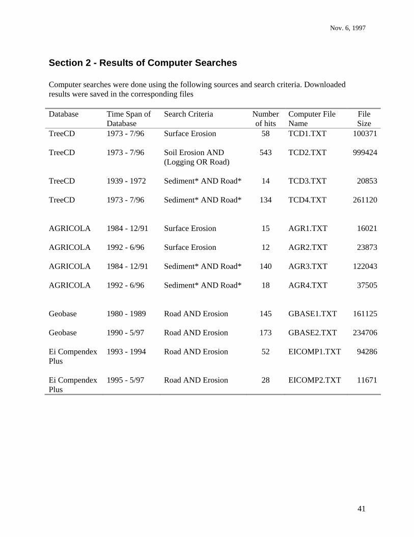
Nov. 6, 1997
41
Section 2 - Results of Computer Searches Computer searches were done using the following sources and search criteria. Downloaded results were saved in the corresponding files Database Time Span of
Database Search Criteria Number
of hits Computer File Name
File Size
TreeCD 1973 - 7/96 Surface Erosion 58 TCD1.TXT
100371
TreeCD 1973 - 7/96 Soil Erosion AND (Logging OR Road)
543 TCD2.TXT 999424
TreeCD 1939 - 1972 Sediment* AND Road*
14 TCD3.TXT 20853
TreeCD 1973 - 7/96 Sediment* AND Road*
134 TCD4.TXT 261120
AGRICOLA 1984 - 12/91 Surface Erosion
15 AGR1.TXT 16021
AGRICOLA 1992 - 6/96 Surface Erosion
12 AGR2.TXT 23873
AGRICOLA 1984 - 12/91 Sediment* AND Road*
140 AGR3.TXT 122043
AGRICOLA 1992 - 6/96 Sediment* AND Road*
18 AGR4.TXT 37505
Geobase 1980 - 1989 Road AND Erosion
145 GBASE1.TXT 161125
Geobase 1990 - 5/97 Road AND Erosion 173 GBASE2.TXT 234706 Ei Compendex Plus
1993 - 1994 Road AND Erosion 52 EICOMP1.TXT 94286
Ei Compendex Plus
1995 - 5/97 Road AND Erosion 28 EICOMP2.TXT 11671