an archaeology of the east midlands. class 6, beeston, winter 2015
TRANSCRIPT

An Archaeology of the East Midlands
Class 6: The Medieval Town in the East Midlands
Tutor: Keith Challis
east-midlands-archaeology.blogspot.co.uk Beeston 2015

Recap: Last Week
• 850-1100 Shaping the Landscape
• Themes in the Medieval Landscape
• Laxton – a Village and its Landscape
east-midlands-archaeology.blogspot.co.uk
• 1300-1485• Population decline• Climate deterioration• Economic troubles• Settlement desertion• Feudal collapse
• 850-1300• The Manor• Nucleation of settlement• Open fields• The Parish• Feudal System
Beeston 2015

Class Summary
• Pre-Conquest Towns– Towns Before the Vikings– The Five Boroughs– Reconquest Towns and Burhs in Mercia
• Post Conquest Towns– Medieval Nottingham
• Chapel Bar and the Town Wall– Map regression
east-midlands-archaeology.blogspot.co.uk Beeston 2015

Learning Outcomes
• Understand a little about the special nature and problems of urban archaeology
• Appreciate some of the archaeological evidence for Late Saxon and Medieval towns in the East Midlands
• Have a good understanding of the basic character of Saxon and Medieval Nottingham
• Understand Map Regression and its uses in urban studies
east-midlands-archaeology.blogspot.co.uk Beeston 2015

Section 1: Pre-Conquest Towns

east-midlands-archaeology.blogspot.co.uk
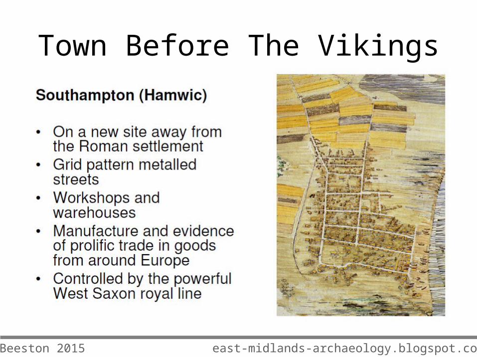
Town Before The Vikings
Life in the Ruins
• Evidence for Early and Middle Saxon occupation in Roman Towns (Leicester/Lincoln) but not urban in character
• In Middle Saxon period Roman Towns may have had special status (Royal/Religious places)
Beeston 2015

Town Before The Vikings
east-midlands-archaeology.blogspot.co.uk Beeston 2015
east-midlands-archaeology.blogspot.co.uk
Town Before The Vikings
Beeston 2015

east-midlands-archaeology.blogspot.co.uk
Town Before The Vikings
Beeston 2015

The Five Boroughs
• The five boroughs of Leicester, Lincoln, Nottingham, Derby and Stamford were the fortified centres of Danish rule of the midlands
• Archaeological evidence is limited (eg only a few objects from Leicester) and often difficult to disentangle Saxon and Danish works (eg at Nottingham)
east-midlands-archaeology.blogspot.co.uk Beeston 2015

The Reconquest of Mercia
• New burghal towns associated with the reconquest of Mercia from the Vikings
• Newark (the New Work) a small Late Saxon burhgal town, perhaps associated with Saxon reconquest of Mercia.
• Excavations of burghal rampart at Slaughterhouse Lane (Morrisons)
• Southwell – recent Late Saxon finds from centre of town and reanalysis of plan suggesting origins as a Late Saxon planned town (a burh)
east-midlands-archaeology.blogspot.co.uk Beeston 2015

Section 2: Post Conquest Towns

Post Conquest Towns
• In general a paucity of archaeological evidence for EM towns as limited excavation and much destruction by cellars, etc.
• Excavation sometimes focused on Roman remains.
• Derby, limited excavation at Full Street in 1970s (medieval pits)
• More recent work at Court House and on Westfield Centre, but limited remains.
east-midlands-archaeology.blogspot.co.uk Beeston 2015

Post Conquest Towns• Leicester and Lincoln better
served in terms of excavation.• Lincoln focus on castle site• Leicester recent excavations
during urban renewal• Important regional town with
several specialist markets, multiple religious houses, industry, etc.
• Highcross Street, rare excavation of a medieval street frontage – occupied from Roman period to the present 3.5m+ of stratified archaeology.
• 10-11th century timber buildings• Cess pits, mash ovens, etc
east-midlands-archaeology.blogspot.co.uk Beeston 2015

Post Conquest Towns
Smaller Towns
• A complex hierarchy of medieval smaller market towns across the East Midlands
• Most with little or no excavation evidence
• What there is often patchy and inconclusive
• Chesterfield – some excavation in 1970s and more recently, focus on Roman period
• Newark, Late Saxon burghal defenses and English Civil War period is main focus
east-midlands-archaeology.blogspot.co.uk Beeston 2015

Post Conquest Towns
• Medieval Nottingham (Discussion)
east-midlands-archaeology.blogspot.co.uk Beeston 2015

Post Conquest Towns
• OriginsOrigins
• Anglo-Saxon BurhAnglo-Saxon Burh
• Norman TownNorman Town
• High Medieval NottinghamHigh Medieval Nottingham
east-midlands-archaeology.blogspot.co.uk Beeston 2015

Post Conquest Towns
east-midlands-archaeology.blogspot.co.uk Beeston 2015

Post Conquest Towns
Anglo-Saxon Burh• In existence before Viking
appropriation in 970s (?)• Certainly in existence by 921
when recaptured by Edward the Elder
• Early buildings (?pre burh) and massive rampart and ditch at Drury Hill
• Ditch at Drury Hill and Woolpack Lane recut in C10
• Post conquest Saxon rampart levelled and ditch filled in and built over
east-midlands-archaeology.blogspot.co.uk
Drury Hill
Beeston 2015

Post Conquest Towns
Anglo-Saxon Burh
• Bow sided timber halls at Woolpack lane and Halifax Place
• Three phases of pre 1000 activity
• Post 1000 reorganisation and new buildings
• C1100 (Post conquest) reorganisation of frontages with corn drying ovens and caves
east-midlands-archaeology.blogspot.co.uk
Halifax Place
Beeston 2015

Post Conquest Towns
The Norman Borough• Nottingham castle (1068)• Norman Borough between
castle and Saxon Burh• Persistent distinction between
Norman and Saxon traditions• Burh defenses filled in and new
earthen rampart by early C12• In old town evidence for internal
reorganisation c1150 and 1300• Industry including malting,
pottery production (Goose Gate) and corn drying (Fisher Gate)
east-midlands-archaeology.blogspot.co.uk
Goose Gate
Beeston 2015

Post Conquest Towns
Later Medieval Nottingham• 1267-1334 grants of
murage add stone wall to rampart
• Cloth manufacture, iron working, tanning and pottery manufacture all evidenced by documents and archeology
east-midlands-archaeology.blogspot.co.uk Beeston 2015

Chapel Bar and The Town Wall
east-midlands-archaeology.blogspot.co.uk
Chapel Bar, Thomas Cooper Moore (1740s) Last surviving medieval town gate
Post Conquest Towns
east-midlands-archaeology.blogspot.co.uk
Post Conquest Towns
east-midlands-archaeology.blogspot.co.uk
Post Conquest Towns
Beeston 2015

east-midlands-archaeology.blogspot.co.uk
Post Conquest Towns
1960s excavation and exposure during redevelopment
Beeston 2015

Map Regression: Rediscovering a Town Plan
•Start with the most recent map, such as a modern Ordnance Survey map and gradually work back through time comparing the relevant maps.
•Map regression is made simpler if all the maps have been reduced or enlarged to the same scale. Maps can then be overlaid.
•A good starting point is to identify a number of features or structures, which have not changed, as this provides a framework from which to start locating other features and comparing maps.
Post Conquest Towns
east-midlands-archaeology.blogspot.co.uk Beeston 2015

1609 1610 1677
1744 1844 1861
Post Conquest Towns

Modern 1861
Post Conquest Towns
east-midlands-archaeology.blogspot.co.uk Beeston 2015

Modern 1861
Work on small areas!
Post Conquest Towns
east-midlands-archaeology.blogspot.co.uk Beeston 2015

Modern 1744
Post Conquest Towns
east-midlands-archaeology.blogspot.co.uk Beeston 2015

Modern 1610
Post Conquest Towns
east-midlands-archaeology.blogspot.co.uk Beeston 2015

Post Conquest Towns

Visualising stratigraphic relationships: town wall at Chapel Bar Nottingham
Post Conquest Towns
east-midlands-archaeology.blogspot.co.uk Beeston 2015

Post Conquest Towns
Chapel Bar and The Town Defences
east-midlands-archaeology.blogspot.co.uk
1960s
Now
Beeston 2015
Further StudyAssignment 6: The Post Medieval East Midlands
What changes overtook the East Midlands in the period 1600-1900?
Think about broad changes affecting towns and the countryside and in particular how each are best evidenced (by archaeology or by documentary history?)
Can you come up with one solid example of significant change (enclosure/industrial growth/population movement, etc.) that is evidenced best by archaeology?
Use the chapters from the East Midland Research Framework on the website as your guide.
east-midlands-archaeology.blogspot.co.uk Beeston 2015