an assessment of soil capability for on-site effluent
TRANSCRIPT

Research Library Research Library
Resource management technical reports Natural resources research
1-1-1989
An Assessment of soil capability for on-site effluent disposal, East An Assessment of soil capability for on-site effluent disposal, East
Carnarvon, Western Australia Carnarvon, Western Australia
M R. Wells
Follow this and additional works at: https://researchlibrary.agric.wa.gov.au/rmtr
Part of the Environmental Public Health Commons, and the Soil Science Commons
Recommended Citation Recommended Citation Wells, M R. (1989), An Assessment of soil capability for on-site effluent disposal, East Carnarvon, Western
Australia. Department of Primary Industries and Regional Development, Western Australia, Perth. Report 79.
This report is brought to you for free and open access by the Natural resources research at Research Library. It has been accepted for inclusion in Resource management technical reports by an authorized administrator of Research Library. For more information, please contact [email protected].

ISSN 0729-3135March, 1989
An Assessment of Soil Capability for On-SiteEffluent Disposal East Carnarvon,
Western Australia
M. Wells
Resource Management Technical Report No.79
AN ASSESSMENT OF SOIL CAPABILITY FR ON-SITE EFFLUENT DISPOSAL EAST CARNARVON, WESTERN AUSTRALIA
ii
Disclaimer
The contents of this report were based on the best available information at the time ofpublication. It is based in part on various assumptions and predictions. Conditions may changeover time and conclusions should be interpreted in the light of the latest information available.
Chief Executive Officer, Department of Agriculture Western Australia 2001

AN ASSESSMENT OF SOIL CAPABILITY FR ON-SITE EFFLUENT DISPOSAL EAST CARNARVON, WESTERN AUSTRALIA
iii
Summary
The capability of soils in East Carnarvon for on-site effluent disposal is assessedprimarily in terms of their absorption ability, purification ability and relative ease ofexcavation. It is considered that soils over the major part of the area have a highcapability for this use. This assessment however makes no attempt to account for socio-economic factors such as the relative cost of providing a deep sewerage system atdifferent levels of subdivision intensity, or the population which could be accommodatedin the area with or without such a system.
Areas of low capability do exist and specific locations are highlighted. These correspondto soils where effluent absorption would be restricted by the relatively impermeablenature of clays, or dense clay barns, at the depth required for leach drain installation.These conditions were met at three of the ten sites examined. This does not necessarilymean that 30% of the area is so affected. Accurate delineation of the extent of these lowcapability areas is possible only with more intensive sampling on a grid basis.
In the areas of low capability it could be possible to overcome the problem of poor soilabsorption through appropriate with design or site modifications. These might include:
• increased lengths of leach drains for conventional systems (possibly requiringlarger lot sizes)
• use of alternating soil absorption systems
• use of systems designed with a significant evapotranspiration component and withgrowth of appropriate shrubs or trees nearby
• deep ripping and incorporation of gypsum into clay layers to improve permeability.
In addition to these factors the useful life of any system could be extended through arequirement for regular maintenance and pumping out.

AN ASSESSMENT OF SOIL CAPABILITY FR ON-SITE EFFLUENT DISPOSAL EAST CARNARVON, WESTERN AUSTRALIA
iiii
Table of Contents
1. Introduction ................................................................................................................. 1
2. Method........................................................................................................................ 3
2.1 General ................................................................................................................ 3
2.2 Land capability assessment................................................................................. 4
3. Results...................................................................................................................... 10
3.1 Description of the land ....................................................................................... 10
3.2 Capability assessment ....................................................................................... 14
3.2.1 Assessment using Department of Agriculture system.................................. 14
3.2.2 Assessment using Department of Health criteria ......................................... 15
4. Discussion ................................................................................................................ 17
4.1 General .............................................................................................................. 17
4.2 The role of evapotranspiration ........................................................................... 17
4.3 Addressing Water Authority queries................................................................... 17
4.3.1 Areas which may be suitable on a permanent basis .................................... 17
4.3.2 Areas generally not suitable or suitable for only short term operation.......... 18
4.3.3 Areas not suitable due to the proximity of the water table............................ 18
4.3.4 Areas with features which could limit performance or make installationexpensive................................................................................................................. 19
References .................................................................................................................... 20
Acknowledgements........................................................................................................ 22
Appendix 1 Schedule G from relevant Health Department Regulations ........................ 23
Appendix 2: Assessment of Land Qualities................................................................... 25
Appendix 3: Calculation of Hydraulic Conductivity from Health Department MinimumPercolation Rate Criteria................................................................................................ 29

AN ASSESSMENT OF SOIL CAPABILITY FR ON-SITE EFFLUENT DISPOSAL EAST CARNARVON, WESTERN AUSTRALIA
1
1. Introduction
This report arises from requests by both the Water Authority of Western Australia andthe Shire of Carnarvon to assess the capability of soils in the East Carnarvon area(Figure 1) to be used for on-site disposal of septic tank effluent. At the time of theserequests the Department of Agriculture was engaged in the description and mapping ofsoil and land types in the Carnarvon Land Conservation District with the objective ofproviding land resource data to assist land use planning. The relatively low intensity ofsite observation, commensurate with the proposed scale of the Land ConservationDistrict mapping, was increased for the East Carnarvon area. The site descriptions werealso supplemented with field measurements of the soil’s saturated hydraulic conductivityat five locations. Due to time constraints the assessment was based on the availableexisting information rather than on a definitive lot by lot examination of soil conditions.
The Water Authority requested the work to identify areas which, from soil type:
(i) may be suitable for the permanent operation of septic tanks and on-site effluentdisposal systems;
(ii) are not generally suitable for use of septic tank systems or only for short termoperation;
(iii) are not suitable for septic tank systems due to the proximity of the water table;
(iv) have particular features which could limit performance or make installationexpensive.
This report addresses these points on the assumption that a conventional system for theon-site disposal and treatment of domestic liquid waste, consisting of one or more septictank units followed by a sub-surface soil absorption system is to be used (Figure 2).Within the Carnarvon area the most commonly used sub-surface soil absorption systemis a 12 m leach drain. The design of the drain is such that, whilst not being a completeevaporation - transpiration - absorption (ETA) process, the system operates with someevaporation-transpiration component (Carnarvon Shire Health Surveyor pers. comm.).
The general approach taken for this study was to provide, from the Department’s currentland resource survey, a brief description of the relevant soil and landform conditions inthe East Carnarvon area. Using that data the area’s capability for on-site effluentdisposal was assessed according to both the criteria developed within the Department ofAgriculture (Wells ‘987) and that contained within the Western Australian Health Act1911-1973 (Department of Public Health undated).

AN ASSESSMENT OF SOIL CAPABILITY FR ON-SITE EFFLUENT DISPOSAL EAST CARNARVON, WESTERN AUSTRALIA
2

AN ASSESSMENT OF SOIL CAPABILITY FR ON-SITE EFFLUENT DISPOSAL EAST CARNARVON, WESTERN AUSTRALIA
3
2. Method
2.1 General
Within the East Carnarvon area ten soil sites were described and of these four werechosen for in situ measurement of saturated hydraulic conductivity (Figure 3). The siteswere chosen following stereoscopic aerial photo examination to determine topographicor remnant vegetation differences within the study area, and in an attempt to allowexamination of a representative cross section of site conditions.
Soil profiles were described from hand auger borings according to the techniques andstandards of the Australian Soil and Land Survey Field Handbook (McDonald et al..1984). Auger borings were made to 150-200 cm depth unless the presence of a densesubsoil clay layer prevented further examination. Data required for standard soildescription and classification include the depth, texture, colour, consistence, structure,fabric and pH of all observable layers or horizons within the soil. These data, inconjunction with measurements of soil surface and landform properties, enable anassessment to be made of the major land qualities which affect effluent disposal. Thesequalities are the soil's absorption ability, its purification ability, and the relative ease ofsite excavation for septic tank or leach drain installation.
Of these qualities, it is the absorption ability of soil which is most commonly used todetermine the suitability or otherwise of a site for effluent disposal. Whilst a qualitativeassessment of absorption ability can be obtained from standard soil survey information,in cases where there is a degree of doubt over site suitability it is desirable tosupplement the qualitative assessment with some quantitative data. For this reasonhydraulic conductivity measurements were undertaken. Hydraulic conductivity, isregarded here as being roughly synonymous with permeability.
The hydraulic conductivity of a soil, K, in m/day defines the volume of water which willpass through unit cross-sectional area of a soil in unit time, given a unit difference inwater potential. This parameter is commonly measured in agricultural soil studies toprovide a guide to water movement and possible drainage problems within soil profiles,and also as a basis for in-field drainage design.
With respect to the ability of soil to absorb septic tank effluent, hydraulic conductivity isrelated to the rate at which effluent can flow away through the soil in both vertical andhorizontal directions from the leach drain. The conductivity of a soil is also correlated tosome extent with the long term infiltration rate of effluent into that soil and is therefore aparameter that should be determined or estimated for all soil layers at or near absorptiontrench level (Brouwer and Bugeja 1979).
There are basically two methods for measuring soil hydraulic conductivity above thewater-table. One method consists of boring a hole to a given depth, filling it with waterand measuring the rate of fall of the water level (Inverse auger-hole method, or Porchetmethod - Van Hoorn 1979). The other method uses apparatus to maintain a constant
AN ASSESSMENT OF SOIL CAPABILITY FR ON-SITE EFFLUENT DISPOSAL EAST CARNARVON, WESTERN AUSTRALIA
4
depth of water in the test hole whilst measurement is made at the rate at which watermust flow in, to maintain the constant level (Modified well permeameter test - Talsmaand Hallarn 1980).
Hydraulic conductivity was measured during the study of the East Carnarvon area usingthe method of Talsma and Hallarn (1980). To approximate the operating depth of aneffluent disposal leach drain, soil hydraulic conductivity was measured for the 30-70 cmdepth interval at each of the four locations. At one of these, an additional measurementwas made for the 110-150 cm depth interval in order to characterize likely conditionsbeneath the drain. Although Talsma and Hallam’s method was used for this study,mention has been made here of the other method as it is relevant to the soil absorptionassessment criteria used by the Department of Health which will be discussed later inthis report.
2.2 Land capability assessment
Land capability is a term used to express the ability of land to support a particular type ofuse without causing permanent damage. Assessment of land capability involves acomparison of the physical requirements for a particular use (in this case, on-siteeffluent disposal) with the existing qualities of the subject land. A five class system,which focuses on land use limitations and risks of land (and water) degradation, isemployed by the Department of Agriculture to express land capability (Table 1).
Land qualities are complex attributes which act in a manner distinct from the actions ofother land qualities in their influence on the capability of land for specified kind of use(FAO 1983). An example is, ‘ease of excavation’. The list of land qualities which areconsidered in the Department’s assessment method, and the related land userequirements for on-site effluent disposal are shown in Table 2. Land characteristics areattributes of land that can be measured or estimated, and can re used to describe landqualities. An example is ‘depth to rock’. The land characteristic data, obtained from theland resource survey, are shown in Table 3. The specific methods to determine suchvalues are given in Appendix 2.
The capability rating for a subject area of land is determined using a land use capabilityrating table (Table 4). This table is an expression of the land use requirements. Therange of each land quality that influences the installation and operation of an effluentabsorption system is divided into classes, each class representing a degree of limitation.At a particular site (or for a particular map unit) the values for land qualities (determinedfrom tables in Appendix 2) are compared with the capability rating table; the mostlimiting land quality determining the overall capability classification. Further details of theland canability assessment system for on-site effluent disposal are given by Wells(1987).
A capability class (I to V) expresses the severity of the land use limitations and a sub-class (letter postcript) may be employed to indicate the nature of the limiting land quality(e.g. a = soil absorption ability). Thus, land rated classes I or II will have qualities whichgenerally meet the requirements of the proposed land use (on-site effluent disposal) with

AN ASSESSMENT OF SOIL CAPABILITY FR ON-SITE EFFLUENT DISPOSAL EAST CARNARVON, WESTERN AUSTRALIA
5
few, if any, limitations or land degradation problems. Land rated classes IV or V is lessable to meet the land use requirements. In these classes it is considered that there aresevere limitations or land degradation hazards which may be impossible to overcome, orat least will require substantial modifications to the proposed form of land use.

AN ASSESSMENT OF SOIL CAPABILITY FR ON-SITE EFFLUENT DISPOSAL EAST CARNARVON, WESTERN AUSTRALIA
6
Table 1. General land capability class definitions
Capabilityclass
Degree oflimitation
General description
I None tovery slight
Very high capability for the proposed activity or use. Veryfew physical limitations present which are easily overcome.Risk of land degradation is negligible.
II Slight High capability. Some physical limitations affecting eitherproductive land use or risk of land degradation. Limitationsovercome by careful planning.
III Moderate Fair capability. Moderate physical limitations significantlyaffecting productive land use or risk of land degradation.Careful planning and conservation measures required.
IV High Low capability. High degree of physical limitations not easilyovercome by standard development techniques and/orresulting in a high risk of land degradation. Extensiveconservation requirements.
V Severe Very poor capability. Severity of physical limitations is suchthat its use is usually prohibitive in terms of eitherdevelopment costs or the associated risk of landdegradation.

AN ASSESSMENT OF SOIL CAPABILITY FR ON-SITE EFFLUENT DISPOSAL EAST CARNARVON, WESTERN AUSTRALIA
7
Table 2. Land qualities and land use requirements for on-site effluent disposal
Land quality Requirement
Absorption ability Soil should be able to effectively absorb, and hencedispose of, the volume of effluent produced from allwaste sources of a single family household (approxflow of 1000 L/d).
Purification ability Soil should be able to effectively purify, largely by theprocess of absorption, microbial contaminants fromeffluent whose presence in groundwater systems maybe hazardous to public health.
Ease of excavation Soil and land surface conditions should be such thatexcavation for the installation of septic tank units andleach drains is not prohibitively expensive.
Water pollution risk Soil and land surface conditions should be such thatnutrient loading of nearby surface
- by overland flow waterbodies or groundwater supplies is not
- by subsurface leaching adversely affected. (The major nutrients of concern arephosphorus and nitrogen and the importance of thisrequirement relates to the significance and current orlikely use of the waterbody or groundwater resource).
Flood hazard The subject area should not be affected by a frequencyor duration of flooding which would prevent effluentdisposal systems from operating and hence pose a riskto public health.

AN ASSESSMENT OF SOIL CAPABILITY FR ON-SITE EFFLUENT DISPOSAL EAST CARNARVON, WESTERN AUSTRALIA
8
Table 3. Land characteristics used to assess qualities which affect effluent disposalcapability
Land qualities Land characteristics
Absorption ability • Site drainage/depth to seasonal water table
• Permeability
• Depth to impermeable layer
• Stone content
Purification ability • Permeability
• Nature of soil; texture and coherence
• Depth to impermeable layer
• Site drainage
• Slope
Ease of excavation • Depth to rock
• Slope
• Stone content
• Rock outcrop
• Site drainage
Water pollution risk 1 (by overland flow)
• Absorption ability
• Runoff
(by subsurface leaching)
• Nature of soil; texture and coherence
Flood hazard • Landform/topographic position2
• Field observation of flood events
Assessed for units at margins of waterbodies, streams and rivers or where land unitsoverlie superficial groundwater aquifers where nutrient loading is of concern.
Correlated with W.A.W.A. flood study mapping.

AN ASSESSMENT OF SOIL CAPABILITY FR ON-SITE EFFLUENT DISPOSAL EAST CARNARVON, WESTERN AUSTRALIA
9
Table 4. Land capability rating table for on-site effluent disposal - areas capable ofbeing used for soil absorption and purification of septic tank effluent from a single familydwelling
Rating 1
Land qualities 1 2 3 4 5
(Nil ..... Degree of limitation ..... Severe)
Soil absorption ability a High Moderate Low Very low -
Soil purification ability p High Moderate Low Very low -
Ease of excavation x High Moderate Low Very low -
Water pollution risk 2
- by overland flow o Very low Low Moderate - High
- by subsurface leaching s - Low Moderate - High
Floor hazard f - - Low Moderate High
Notes
Capability class, expressed in Roman numerals, is determined by the most limitingrating.
Pollution risk considerations generally only apply to map units at margins of a waterbodyor overlying superficial aquifers which feed into environmentally sensitive waterbodies.

AN ASSESSMENT OF SOIL CAPABILITY FR ON-SITE EFFLUENT DISPOSAL EAST CARNARVON, WESTERN AUSTRALIA
10
3. Results
3.1 Description of the land
The study area occurs on an alluvial levee formed by riverine deposits of the GascoyneRiver. The soils have been previously mapped at a very broad scale (1:126720) byCSIRO (Bettenay get al.. 1971). At that mapping scale the entire study area isrepresented by the Gascoyne soil association which is described as mainly brownuniform profiles with textures varying from loamy fine sand (Uc5.32*) to silty barns(Um5.2) and silty clay barns (Um5.12). The original vegetation of the area is likely tohave been a moderately close, tall shrubland or woodland of acacias with fringingcommunities of coolibah and rivergum (Payne. 1987). At the time of this survey the areawas almost entirely cleared and partly urbanized. The area has been extensively usedfor irrigated horticulture in the past and at least one plantation remained at the time ofthe survey.
The results of the land resource survey investigation of the East Carnarvon area areshown on Figure 3. The area has been subdivided into four topographic units by aerialphoto interpretation. For each unit the soils are described on the basis of a limitednumber of sites within the study area, and by extrapolation of data from sites describedelsewhere during the Department’s broader scale survey of the Land ConservationDistrict.
The only significant relief in the study area is offered by the low, very gently undulatingdune ridges (map units A and B, Figure 3) which are up to an estimated 6m relief withslopes ranging from 1 to 5%. The soils are deep to very deep, rapidly drained, brownishsiliceous sands or sandy barns (Ucl.23). They are very permeable and exhibit a neutralsoil reaction trend. Little if any rainfall runoff is generated from these areas.
The major part of the study area consists of alluvium (map unit C, Figure 3) which isvariable in terms of the soil’s texture and drainage characteristics. The absence oforiginal vegetation and the degree of land disturbance over much of this area makes itimpossible to distinguish any surface expression of soil properties relevant to the study.Eight sample sites located to give a broad cross-section of the area reveal, to someextent, the degree of soil variation (Tables 5a and 5b).
Tables 5a and 5b also summarise the hydraulic conductivity measurements. Thesevalues generally fall at the lower end of the range of variation expected for each soiltexture type according to published literature (Dent and Young 1981). It is suggestedthat the low values are the ~ of soil compaction and hardpan formation due to pastcultivation and/or traffic pressure. This is supported by research at the CarnarvonAgricultural Research Station (Department of Agriculture 1986) which shows hydraulicconductivity values as low as 0.06 m/day in areas subject to frequent tractor traffic,where the soils might otherwise be expected to have values in the range of 0.5 to 1.5m/day based on their texture. The trials also showed that permeability in these soils canbe significantly improved through deep ripping and the application of gypsum.

AN ASSESSMENT OF SOIL CAPABILITY FR ON-SITE EFFLUENT DISPOSAL EAST CARNARVON, WESTERN AUSTRALIA
11
* Principal Profile Form classification according to Northcote (1969) - Further descriptionof soils classified under this system may be found in Northcote et al. (1975).
The most common soils of map unit C (Figure 3) are uniform reddish brown noncalcareous barns (Um5.2) consistent with the medium textured variety of the Gascoynesoil association. These soils are deep and generally well drained, with moderate tomoderately rapid permeabilities, and neutral to slightly alkaline reaction trends. They areeither weakly structured or massive with a porous, earthy fabric. Site 426 is considered atypical Gascoyne soil, site 427 being a heavier (more clayey) variant, and sites 385 and386 show that in some areas the soil may occur on top of other alluvial sand or claylayers at varying depths. The soil and site 429 is an earthy loam with a red brownhardpan (Um5.3). The hardpan occurs beneath 60 cm depth and is likely to be the resultof past cultivation and traffic effects.
Less commonly occurring within map unit C are the alkaline red duplex soils (Dr2.53)represented by sites 388 and 393, and a heavier textured variant of the Gascoyne Soilassociation with a traffic or cultivation induced hardpan within 60 cm depth (Um5.3)represented by site 387. These soils have a moderately slow to slow permeability due todense, weakly structured subsoil clay or clay loam layers. The subsoil layers are slightlysalt affected and the restriction to drainage may cause perched water tables to developafter significant rain periods. These soils represent an intergrade between the Gascoyneand Coburn soil associations (Bettenay et al. 1971).
The relatively bow site density and lack of surface vegetation or aerial photo patternfeatures prevent the drawing of a boundary between the two major groupings of soilswithin map unit C (Figure 3). The soil sites where drainage, and hence soil absorption, islikely to be limited have however been highlighted.

AN ASSESSMENT OF SOIL CAPABILITY FR ON-SITE EFFLUENT DISPOSAL EAST CARNARVON, WESTERN AUSTRALIA
12
Table 5a. Variation in soil properties within map unit C - sites of high capability
Soil characteristic Site No.385 386 426 427 429
Surface texture SL LFSY SL SL SLTexture at 20-60cm S LFSY LFSY ZL SCLTexture below60cm
ZL-LC S-CLFS LFSY-FSL ZCL-CL ?hardpan
Soil permeability*-assessed Mod rapid Moderate Moderate Moderate Moderate –
ModeratelySlow
- measured 0.79 m/day - 0.28 m/day 0.20m/day -(hydraulicconductivity)
0.01 m/day**
* Refer to Appendix 2 for correlation between assessed and measured values.** Measurement within subsoil clay, all other made at approximate depth of leach drain.
Table 5b. Variation in soil properties within map unit C - sites of low capability
Soil characteristic Site no.387 398 393
Surface texture LFSY CL** SLTexture at 20-60 cm LSFY-LC LC MCTexture below 60 cm LC LC LMCDepth to clay (cm) 40 5 10Soil permeability*- assessed Mod slow-Slow Slow Slow-measured(hydraulic conductivity)
0.01 m/day - -
* Refer to Appendix 2 for correlation between assessed and measured values.**Not considered to be the original surface – site disturbed.
Textures
S SandSL Sandy loamLFSY Loam fine sandyFSL Fine sandy loamSCL Sandy clay loamZL Silty loamZCL Silty clay loamCL Clay loamCLFS Clay loam fine sandyLC Light clayLMC Light to medium clayMC Medium clay

AN ASSESSMENT OF SOIL CAPABILITY FR ON-SITE EFFLUENT DISPOSAL EAST CARNARVON, WESTERN AUSTRALIA
13

AN ASSESSMENT OF SOIL CAPABILITY FR ON-SITE EFFLUENT DISPOSAL EAST CARNARVON, WESTERN AUSTRALIA
14
3.2 Capability assessment
3.2.1 Assessment using Department of Agriculture system
Under this system five land qualities are normally assessed to determine land capabilityfor effluent disposal from septic tanks. These are:
• absorption ability, purification ability,
• ease of excavation,
• water pollution hazard and flood hazard.
For this assessment of the East Carnarvon area however, flood hazard is not relevantdue to the presence of a protective levee system.
Water pollution risk by nutrient enrichment has also not been directly considered in thecapability rating. Although both phosphorous and nitrogen are present in high amountsin septic tank effluent (Whelan et al.. 1981) phosphorus travel appears to be very limitedexcept under saturated circumstances in coarse sandy soils. Brouwer and Bugeja(1979) report that although nitrate-nitrogen travel is very extensive, it must be kept inmind that water flow is the vector and in many Australian situations, there may be little orno flow of soil water or effluent for any significant distance from an absorption field. Thiswould appear to be the case in East Carnarvon given the presence of loamy to claysubsoils over most of the area.
Water pollution by nutrient enrichment need not be considered further because theunderlying groundwater resource in this area is not used for drinking water. There arealso no open water bodies in the vicinity where eutrophication might result from nutrientenrichment. Should the issue still cause concern, it is suggested that the appropriatecriteria to use is a minimum depth to the water table of 1.2 m below the base of theleach drain (Wagner and Lanoix 1958). The land resource survey in this area did notobtain information on the depth to groundwater.
The capability assessment is therefore primarily based on three land qualities,absorption ability, purification ability and ease of excavation. Table 6 summaries theland quality values and capability ratings. Using the criteria in Appendix 2 band qualityvalues have been determined for each map unit, and within the variable map unit C theyhave been determined for each specific site. The capability rating is derived by matchingthese values against those in the capability rating table (Table 4).
The results in Table 6 indicate that soils over the major part of the East Carnarvon areaare likely to have a high capability for effluent disposal. Within the most extensive mapunit (C) there are areas which have a low capability (Class IV). These sites are indicatedon Figure 3. A more accurate delineation of these low capability soils is not possiblewithout an intensive grid survey concentrating on the depth to clay or hardpan layer.

AN ASSESSMENT OF SOIL CAPABILITY FR ON-SITE EFFLUENT DISPOSAL EAST CARNARVON, WESTERN AUSTRALIA
15
Table 6. Land qualities and capability ratings
Land qualities1
MapUnit
Siteno.
Soil purificationability –p
Ease ofexcavation –x
Soil absorptionability – a
Capabilityrating3
A 420428 High High High I
B Moderate High High II
385 High High Moderate2 II386 High High Moderate II387 Moderate High Low-very low2 IVa388 Low Moderate Low-very low IVa393 Low Moderate Low-very low IVa426 High High Moderate2 II427 High High Moderate2 II
C
429 Moderate Moderate Moderate II
D High Moderate Moderate II
1. Values for land qualities determined by comparing site or map unit date with tablesin Appendix 2.
2. Absorption ability principally determined by hydraulic conductivity measurements.3. Capabilities rating determined b matching land quality values against positions in
Table 4. Sub class postscripts are shown for low capability sites (e.g. a =Absorption ability).I = very high capability, II = High capability, IV = low capability.
3.2.2 Assessment using Department of Health criteria
Within Western Australia septic tank systems are constructed and operated to standardsspecified on the Bacteriolytic Treatment of Sewage and Disposal of Effluent and LiquidWaste Regulations 1973. With respect to the capability of soil, schedule G of theseregulations (Appendix 1) describes a technique to determine the absorption capacity ofthe soil. Using this technique a soil with a percolation rate of less than 2.5 cm per hour isdeemed unsuitable for use as an effluent disposal field.
Percolation rate is however not an intrinsic soil property and can vary with different sizedtest holes and with wetting depth. With a knowledge of the test hole dimensions therecommended minimum percolation rate can be converted to an unambiguous saturatedhydraulic conductivity figure (refer Appendix 3). For Western Australia this minimum rateis equivalent to a saturated hydraulic conductivity of 0.25 m/day. This compares with afigure of 0.21 m/day used in Victoria (E.P.A. Victoria figure quoted in Brouwer et al.,.1982) and 0.10 day/day used in the United States (Otis et al. 1980).

AN ASSESSMENT OF SOIL CAPABILITY FR ON-SITE EFFLUENT DISPOSAL EAST CARNARVON, WESTERN AUSTRALIA
16
Using these criteria the hydraulic conductivity results in Table 5 show that the duplex soiltypes and the heavier Gascoyne soil variant are likely to fail the test. For site 427 theresult is considered marginal in view of the limited number of site replications and due tothe inherent variability of individual hydraulic conductivity values made by any fieldmethod. Generally however, an assessment of the results according to Department ofHealth criteria is consistent with one which uses the Department of Agriculture’s system.It is the soils where a clay or dense clay loam hardpan layer occurs within the depth tobe occupied by leach drains, that have a low capability for on-site effluent disposal.

AN ASSESSMENT OF SOIL CAPABILITY FR ON-SITE EFFLUENT DISPOSAL EAST CARNARVON, WESTERN AUSTRALIA
17
4. Discussion
4.1 General
This assessment of soil capability for on-site effluent disposal in East Carnarvon focuseson the ability of the soils to be used for that purpose based on three primary factors -their absorption ability, their purification ability and their relative ease of excavation.
In deriving the capability ratings no account is taken of socio-economic factors. Themost notable of these factors is the relative cost of providing a reticulated seweragescheme to the area. At present there is relatively little land subdivision and developmentalthough some time in the future intensive development may occur. More intensivesubdivision, and hence a greater population, could be accommodated in the area if it.were skewered, compared to the present situation where relatively large lot sizes aredictated by the need for areas free of buildings, sheds, pools etc. for soil based effluentdisposal systems.
4.2 The role of evapotranspiration
The evaluation of land for septic effluent disposal depends on the ability of soilssurrounding leach drains to absorb liquid effluent. Current standards relate to minimumpermissable hydraulic conductivities of 0.25 day/day in Western Australia and 0.21day/day in Victoria. Research has shown however, that disposal fields in Victoria canfunction quite well on soils with lower conductivities (Brouwer et al.. 1979, Brouwer andBugeja 1979, van de Graaff et al. 1980). This is explained by Brouwer et al.. (1982) asbeing due to the role evapotranspiration plays in effluent disposal by leach drains.
In contrast with the United States where much of Victoria and Western Australia’seffluent disposal design criteria originated, Australian winters are relatively mild,potential evaporation in winter is still appreciable, and trees and shrubs are mostly non-deciduous. In the Carnarvon area, with a semi arid climate the role of evapotranspirationin supplementing the soil absorption process is likely, depending on the system design,to be substantially greater than that observed in Victoria. As a result assessments basedon absorption criteria alone may penalise development using septic tanks.
4.3 Addressing Water Authority queries
4.3.1 Areas which may be suitable on a permanent basis
The soils of map units A and B, and the light to medium textured Gascoyne soils (majorareas) within map unit C, are most capable of being used for effluent absorption. Thelength of time any soil absorption system can operate is a matter of conjecture and willbe related to the adequacy of the original design criteria and the frequency ofmaintenance.
In the recent report of the Select Committee appointed to inquire into effluent disposal in

AN ASSESSMENT OF SOIL CAPABILITY FR ON-SITE EFFLUENT DISPOSAL EAST CARNARVON, WESTERN AUSTRALIA
18
the Perth Metropolitan Region (Alexander 1988) it was considered that septic tanksystems in their present mode (as in Carnarvon) are unacceptable as a long termeffluent disposal solution, and that even in areas of suitable soil and site conditions,septic tank systems do not operate indefinitely and regular maintenance is required.This is supported by the Caldwell Connell Report (1986) which found that soil absorptionsystems progressively clog until relatively low equilibrium infiltrations are obtained.Whether or not these low equilibrium values are sufficient will depend on the adequacyof the original design, specifically trench length, and on the relative size of theevapotranspiration component in the process.
A somewhat contrary opinion to that of the Select Committee is offered by Brouwer andBugeja (1979) who cite work by Machmeier (1975) and Healy and Laak (1974) asevidence, that as long as the field is not overloaded and the septic tank is regularlypumped out, the life span of an absorption field is indefinite. They consider however thatas overloading may at times take place it may be wise to leave room for a replacementabsorption field.
4.3.2 Areas generally not suitable or suitable for only short term operation
The duplex soils and heavier textured Gascoyne soils within map unit C would generallyfit into this category. However it is important to realize that factors such as an increase inthe size of an absorption field, and better management and maintenance of septicsystems, can reduce the incidence of failure in these areas.
In their recent study of on-site waste water disposal systems, Caldwell ConnellEngineers (1986) have prompted improvements to be made to the interpretation of theHealth Department assessment technique. Loading infiltration rates for both alternatingand non alternating leach drain systems are now related both to broad soil types andpercolation rate criteria. For relatively impervious clay soils where the percolation rate isexpected to be slower than 2.5 cm per hour, it is suggested that the soils in their naturalstate are unsuitable for on-site disposal and require system design and site modification(Department of Health - pers. comm.). This recognizes an important point that soilcapability is not a clear cut factor. In any location where septic tanks are proposed,absorption field size, trench lengths and system types should be related to the land orsoil conditions, and to the particular vegetation cover and climatic conditions. In otherwords, in most situations knowledge of the soil or land conditions can be used to ‘designaround’ or overcome potential problems for effluent disposal.
4.3.3 Areas not suitable due to the proximity of the water table
For this survey, no specific data on the depth to the water table has been obtained in theEast Carnarvon Area. The study concentrated on soil and landform properties. Therewas no evidence, in terms of either subsoil mott1~1g or vegetation indicator species, tosuggest the presence of a water table within 1.8 m of the soil surface, other than as atemporary perching of water above the clay layer in duplex soils.
AN ASSESSMENT OF SOIL CAPABILITY FR ON-SITE EFFLUENT DISPOSAL EAST CARNARVON, WESTERN AUSTRALIA
19
4.3.4 Areas with features which could limit performance or make installationexpensive
The performance of effluent disposal systems is judged, more than any other singlefactor, on the ability of soils to adequately absorb effluent at the required loading rates.Within the study area performance is likely to be limited only by the duplex soil types orthe heavier textured Gascoyne soils where clay, or dense compacted clay loam, layersoccur within 60 cm of the surface. Sites where these conditions have been encounteredare highlighted in Figure 3. Further delineation of these areas could only be made bysystematic sampling on a grid survey basis.

AN ASSESSMENT OF SOIL CAPABILITY FR ON-SITE EFFLUENT DISPOSAL EAST CARNARVON, WESTERN AUSTRALIA
20
References
Alexander, I. (1988). Report of the Select Committee Appointed to Inquire into EffluentDisposal in the Perth Metropolitan Region, Western Australia. A report to theWestern Australian Legislative Assembly (August).
Bettenay, E., Keay, J. and Churchward, H.M. (1971). ‘Soils adjoining the GascoyneRiver near Carnarvon, Western Australia’ Soils and Land Use Series No. 51.Division of Soils C.S.I.R.O. Australia.
Brouwer, J. and Bugeja R.M. (1979). Land capability for septic tank effluent absorptiontrenches. Report A.W.R.C. Project 79/118, State Rivers and Water SupplyCommission, Armadale, Victoria.
Brouwer, J., van de Graaff, R.H.M., Bugeja, R.M., and Willatt, S.T. (1982). ‘On-siteseptic tank effluent disposal through soil absorption and evapotranspiration - aworking model’. Paper presented at the Australian Soil Science SocietyConference, Canberra - May 1982.
Brouwer, J.,, Willatt, S.T. and van de Graaff, R.H.M. (1979). The hydrology of on-siteseptic tank effluent disposal on a yellow duplex-like soil. Hydrology and WaterResources Symposium, Perth, W.A., Symposium papers, pp. 112-117.
Caldwell Connell Engineers Pty. Ltd. (1986). On-site wastewater disposal systems. FinalReport to Water Authority of Western Australia, Perth.
Dent, D., and Young, A. (1981). Soil Survey and Land Evaluation. George Allan andUnwin (publishers) Ltd. London, p. 236.
Department of Agriculture (1986). Determinate Tomato Irrigation Trial (No.1 1986). Final(unpublished) report. Department of Agriculture, Carnarvon Office. File No. 426.05.
Department of Public Health W.A. (Undated). Bacteriolytic Treatment of Sewage andDisposal of Effluent and Liquid Waste Regulations. Schedule ‘G’ Department ofPublic Health.
FAO (1983). Guidelines : land evaluation for rainfed agriculture. Soils Bulletin No. 52.Food and Agriculture Organization of the United Nations, Rome.
Healy, K.A. and Laak, R. (1974). Site evaluation and design of seepage fields. J.Environ. Eng. Div. A.S.C.E. 100:1133-46.
Machmeier, R.E. (1975). Design criteria for soil treatment systems. Sci. J. Series Paper9358, Minn. Agric. Ex. Stn. St. Paul, Minnesota.
McDonald, R.C., Isbell, R.F., Speight, J.G., Walker, J. and Hopkins, M.S. (1984).‘Australian Soil and Land Survey Field Handbook’. Inkata Press Pty. Ltd.,

AN ASSESSMENT OF SOIL CAPABILITY FR ON-SITE EFFLUENT DISPOSAL EAST CARNARVON, WESTERN AUSTRALIA
21
Melbourne.
Northcote, K.H. (1969). ‘A Factual Key for the Recognition of Australian Soils’.C.S.I.R.O. 4th Edition, Rellim Technical Publications Pty. Ltd., Adelaide, SouthAustralia.
Northcote, K.H., Hubble, G.D., Isbell, R.F., Thompson, C.H. and Bettenay, E. (1975). ‘ADescription of Australian Soils’. C.S.I.R.O.: Australia.
Otis, R.J., Boyle, W.C., Clements, E.V. and Schmidt, C.J. (1980). Design manual for on-site waste-water treatment and disposal systems. Published by the U.S.Environmental Protection Agency, Report No. EPA -625/1-80-012, 412 pp.
Payne, A.L., Curry, P.J. and Spencer, G.F. (1987). An inventory and condition survey ofrangelands in the Carnarvon Basin, Western Australia. Technical Bulletin No. 73.Western Australian Department of Agriculture.
Talsma, T., and Hallam, P.M. (1980). Hydraulic conductivity measurements of forestcatchments. Aust. J. Soil Research, Vol. 18, No.2, P. 139-148.
van de Graaff, R.H.M.., Brouwer J and Willatt, S.T. (1980). On-site septic tank effluentabsorption - the effects of soil and band features. Paper presented at the nationalSoils Conference, Australian Society Soil Science Inc., Sydney.
van Hoorn, J.W. (1979). Determining hydraulic conductivity with the inversed augerholeand infiltrometer methods. Paper 1.06. In: Wesseling, J. (Editor). Proc.International Drainage Workshop, May, 1978, Wageningen. Publ. No. 25,International Inst. for Land Reclamation and Improvement, Wageningen, TheNetherlands.
Wagner, E.G. and Lanoix, J. (1958). Excreta disposal for rural areas. Monograph No.39. World Health Organization, Geneva.
Wells, M.R. (1987). Assessment of land capability for on-site septic tank effluentdisposal. Technical Report No. 63. Division of Resource Management, WesternAustralian Department of Agriculture.
Wells, M.R. and King, P.D. (1988). Land Capability Assessment for Rural ResidentialDevelopment and Hobby Farming. Technical Bulletin in preparation, WesternAustralian Department of Agriculture.
Whelan, B.R., Barrow, N.J. and Carbon, B.A. (1981). Movement of Phosphate andNitrogen from Septic Tank Effluent in Sandy Soils near Perth, Western Australia.In: Lawrence, C.R. and Hughes, R.J. (eds). Proc. Groundwater PollutionConference (1979). AWRC conf. series No. 1 pp. 391-401.

AN ASSESSMENT OF SOIL CAPABILITY FR ON-SITE EFFLUENT DISPOSAL EAST CARNARVON, WESTERN AUSTRALIA
22
Acknowledgements
Ms Colma Keating and Mr John Bessell-Browne assisted during field work in Carnarvonand in the subsequent analysis of data in Perth. Constructive editorial criticism wasreceived from Mr Jim Dixon.

AN ASSESSMENT OF SOIL CAPABILITY FR ON-SITE EFFLUENT DISPOSAL EAST CARNARVON, WESTERN AUSTRALIA
23
Appendix 1 Schedule G from relevant Health DepartmentRegulations
Schedule “G”Health Department
FORMULA FOR DETRMINING ABSORPTIVE CAPACITY OF SOIL.
1. Dig a hole with dimensions of 300 mm square and vertical sides to the depth ofthe proposed absorption trench.
2. Carefully scarify the bottom and sides of the hole in order to remove any smearedsoil surfaces and to provide a natural soil interface into which the water may percolate.Remove all loose material from the hole. Add 50 mm of blue metal, or screened gravel,to protect the bottom from scouring and sediment.
3. Fill the hole with water and allow it to soak away. Preferably keep the hole filledovernight. possibly by means of an automatic siphon.
4. The following morning, fill or adjust water level to a depth of 150 mm above bluemetal or gravel, insert measuring stick (as shown) and note time taken for water to fall25 mm.
The amount of effluent which can be disposed of per square metre of trench bottom perday is given by the following table:-
Time for water to Fall 25mm.
Dose per 0.09 square metreof Trench Bottom.
1 minute 14 litres2 minutes 11 litres5 minutes 10 litres10 minutes 7 litres30 minutes 3.5 litres60 minutes 2 litres
Over 60 minutes Soil unsuitable.
The use of a diversion pit and stop board to divert drainage from one line of drain toanother is recommended where large quantities of water are to be disposed of intodifficult soils.

AN ASSESSMENT OF SOIL CAPABILITY FR ON-SITE EFFLUENT DISPOSAL EAST CARNARVON, WESTERN AUSTRALIA
24
31259/2/84 By Authority, WILLIAM C. BROWN, Government Printer

AN ASSESSMENT OF SOIL CAPABILITY FR ON-SITE EFFLUENT DISPOSAL EAST CARNARVON, WESTERN AUSTRALIA
25
Appendix 2: Assessment of Land Qualities
The following tables, reproduced from Wells and King (1988) illustrate how values canbe determined for land qualities, from land characteristic data. The standard terminologyused to describe each land characteristic is defined in the Australian Soil and LandSurvey Handbook (McDonald et al. 1984).
Table A2.l Assessment of land quality - Absorption ability1
Land characteristic Rating
High Moderate Low Very low
Permeability class. Very rapid-Rapid
Moderate-Moderatelyrapid
Moderatelyslow
Slow
(Hydraulicconductivity)2
> 1 m/day 0.05 1 m/day 0.01-05 m/day < 0.01 m/day
Drainage class3 Well-Rapid Moderatelywell –Imperfect
Poor Very poor
Depth toimpermeable layer
Deep Moderatelydeep
Shallow Very shallow
Stone within profile Nil – Common Many Abundant Veryabundant
NOTES:
1. The rating will be determined by that of the most limiting land characteristic
2. Permeability is a composite expression of soil properties and depends largely onsoil texture, soil structure, the presence of pans and the size and distribution ofpores in the soil. Permeability categories are essentially ranges of hydraulicconductivities. Permeability categories are assigned during a soil survey based ona consideration of the above factors. Where hydraulic conductivity measurementshave been made these can be used in lieu of the empirical assessments ofpermeability category.
3. For many soil surveys drainage class will need to be used in lieu of ‘depth toseasonal water table’. If however, sufficient depth data are available, Departmentof Health criteria should be used for site specific assessment. i.e. 1.2 m belowbase of effluent leach drains, or 1.8 m below soil surface is sufficient, and for thepurpose of determining a capability rating, absorption ability is automatically high.
4. If the absorption ability is low or very low there will be a high risk of on-sitepollution.

AN ASSESSMENT OF SOIL CAPABILITY FR ON-SITE EFFLUENT DISPOSAL EAST CARNARVON, WESTERN AUSTRALIA
26
Table A2.2 Assessment of land quality - Soil purification ability
Permeability(hydraulic conductivity)
Nature of soil Depth toimpermeable
layer1
Rating 2, 3
Moderately rapid – Veryrapid (. 0.5 m day-1)
(i) Sands: Grey or very paleleached sands with littlecoherence, andcalcareous sands.
> 5 m< 5 m
LowVery low
(ii) Coloured sands (usuallyyellowish brown to red)and earthy sands withslight to moderatecoherence.
> 2 m1 – 2 m< 1 m
HighModerate
Low
Moderate – Slow(< 0.05 m day-1)
Soils with loamy textures orheavier
> 1 m0.5-1 m< 0.5 m
HighModerate
Low
1. Depth to rock, impermeable poor structured clay, or seasonal water table ifknown.
2. If site drainage is very poor soils will be insufficiently aerated for bacterialbreakdown of effluent components. Rating is automatically very low.
3. On steep slops where permeability is moderate-slow, lateral seepage mayintercept the surface resulting in ineffective purification. Where soils have amoderate-slow permeability and slope is 20-30%, the rating is automatically low.If slope is > 30% rating is very low.
Table A2.3 Assessment of land quality - Water pollution risk by overland flow
Absorption ability1 Runoff rate Risk rating
High - Very low
Moderate Nil-Slow Low
Moderately rapid – Very rapid Moderate
Low or Very low Nil-Slow Moderate
Moderate rapid – Very rapid High
1. Determined from Table A2.1
2. If the site is subject to a high flood hazard, the pollution risk rating is automaticallyvery high. For a moderate flood hazard it is high. For a low flood hazard, it ismoderate.

AN ASSESSMENT OF SOIL CAPABILITY FR ON-SITE EFFLUENT DISPOSAL EAST CARNARVON, WESTERN AUSTRALIA
27
Table A2.4. Assessment of land quality - Water pollution risk by subsurfacebeaching
Soil description Nutrient retentionrating
Pollution riskrating
Deep grey leached siliceous sands whereiron-organic pans, if present, are weak andoccur at depths greater than 1 m.
Very low High
Grey leached sands or sandy loams withiron-organic hardpan within 1 m.
Duplex soils with moderately deep (50-100cm) sandy leached topsoils, or sands ofsimilar depth overlying unrelated clay
Shallow gravelly sands over rock.
Low High
Sands and earthy sands with colouredsubsoils.
Deep gravelly sands or gravelly duplexsoils.
Calcareous sands.
Duplex soils with shallow (c 50 cm) topsoils.
Moderate Moderate
Uniform loamy soils.
Gradational earths.Moderately high Low
Uniform clay loams or clays. High Low
AN ASSESSMENT OF SOIL CAPABILITY FR ON-SITE EFFLUENT DISPOSAL EAST CARNARVON, WESTERN AUSTRALIA
28
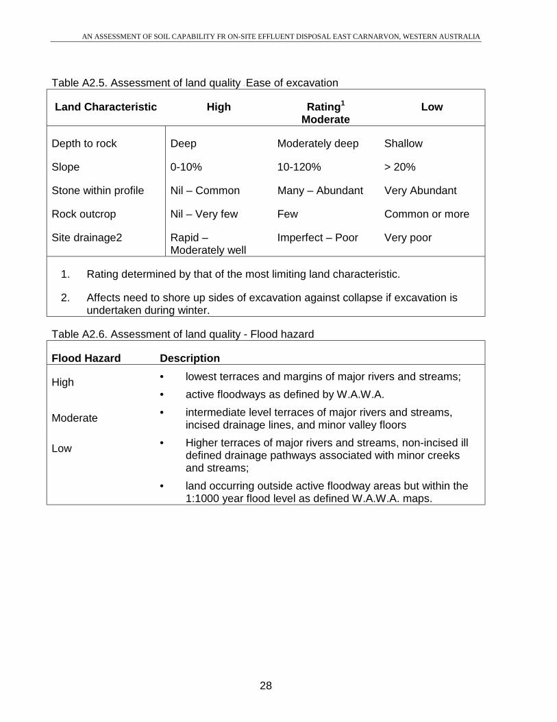
Table A2.5. Assessment of land quality - Ease of excavation
Land Characteristic High Rating1
ModerateLow
Depth to rock Deep Moderately deep Shallow
Slope 0-10% 10-120% > 20%
Stone within profile Nil – Common Many – Abundant Very Abundant
Rock outcrop Nil – Very few Few Common or more
Site drainage2 Rapid –Moderately well
Imperfect – Poor Very poor
1. Rating determined by that of the most limiting land characteristic.
2. Affects need to shore up sides of excavation against collapse if excavation isundertaken during winter.
Table A2.6. Assessment of land quality - Flood hazard
Flood Hazard Description
High • lowest terraces and margins of major rivers and streams;
• active floodways as defined by W.A.W.A.
Moderate • intermediate level terraces of major rivers and streams,incised drainage lines, and minor valley floors
Low • Higher terraces of major rivers and streams, non-incised illdefined drainage pathways associated with minor creeksand streams;
• land occurring outside active floodway areas but within the1:1000 year flood level as defined W.A.W.A. maps.
AN ASSESSMENT OF SOIL CAPABILITY FR ON-SITE EFFLUENT DISPOSAL EAST CARNARVON, WESTERN AUSTRALIA
29
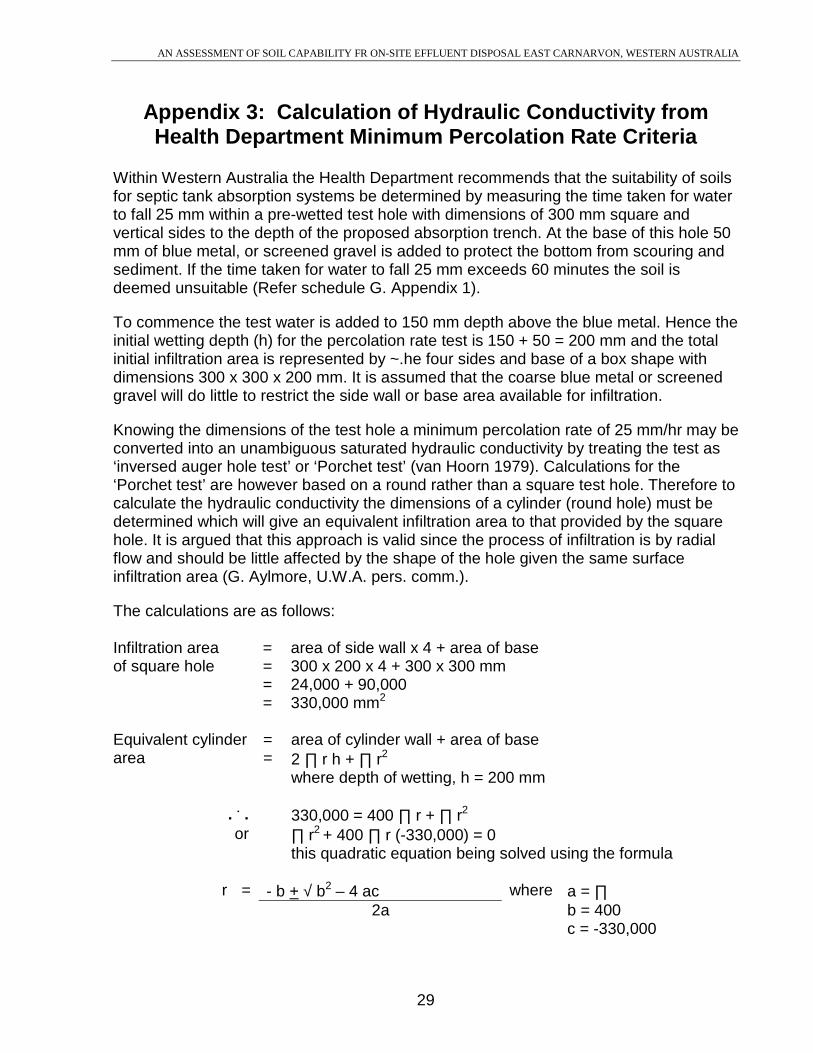
Appendix 3: Calculation of Hydraulic Conductivity fromHealth Department Minimum Percolation Rate Criteria
Within Western Australia the Health Department recommends that the suitability of soilsfor septic tank absorption systems be determined by measuring the time taken for waterto fall 25 mm within a pre-wetted test hole with dimensions of 300 mm square andvertical sides to the depth of the proposed absorption trench. At the base of this hole 50mm of blue metal, or screened gravel is added to protect the bottom from scouring andsediment. If the time taken for water to fall 25 mm exceeds 60 minutes the soil isdeemed unsuitable (Refer schedule G. Appendix 1).
To commence the test water is added to 150 mm depth above the blue metal. Hence theinitial wetting depth (h) for the percolation rate test is 150 + 50 = 200 mm and the totalinitial infiltration area is represented by ~.he four sides and base of a box shape withdimensions 300 x 300 x 200 mm. It is assumed that the coarse blue metal or screenedgravel will do little to restrict the side wall or base area available for infiltration.
Knowing the dimensions of the test hole a minimum percolation rate of 25 mm/hr may beconverted into an unambiguous saturated hydraulic conductivity by treating the test as‘inversed auger hole test’ or ‘Porchet test’ (van Hoorn 1979). Calculations for the‘Porchet test’ are however based on a round rather than a square test hole. Therefore tocalculate the hydraulic conductivity the dimensions of a cylinder (round hole) must bedetermined which will give an equivalent infiltration area to that provided by the squarehole. It is argued that this approach is valid since the process of infiltration is by radialflow and should be little affected by the shape of the hole given the same surfaceinfiltration area (G. Aylmore, U.W.A. pers. comm.).
The calculations are as follows:
Infiltration area = area of side wall x 4 + area of baseof square hole = 300 x 200 x 4 + 300 x 300 mm
= 24,000 + 90,000= 330,000 mm2
Equivalent cylinder = area of cylinder wall + area of basearea = 2 ∏ r h + ∏ r2
where depth of wetting, h = 200 mm
. . . 330,000 = 400 ∏ r + ∏ r2
or ∏ r2 + 400 ∏ r (-330,000) = 0this quadratic equation being solved using the formula
r = - b + √ b2 – 4 ac where a = ∏2a b = 400
c = -330,000

AN ASSESSMENT OF SOIL CAPABILITY FR ON-SITE EFFLUENT DISPOSAL EAST CARNARVON, WESTERN AUSTRALIA
30
. . . r = -400 + √ 4002 – 4 ∏ (-330,000)2 ∏
= -400 + √ 160,000 + 1,320,000 ∏2 ∏
= -400 + √ 160,000 + 4,146,902.32 ∏
= -400 + √ 4,306,902.32 ∏
= -400 + 2,075.32 ∏
= 1,675.3 = 1,673.3 = 266.64 mm2 ∏ 6.283
Radius of cylinder (round hole) of equivalent area to Department of Health’s square holetest is 266.6 mm.
Using the Porchet method hydraulic conductivity K, is calculated using the formulaK = 1.15 r [log (h (ti) + r/2) – log (h (tn) + r/2)]
tn - ti
where radius of test hole r = 26.664 cminitial wetting depth h(ti) = 20 cmfinal wetting depth h(tn) = 17.5cm (20 minus require fall distance of 2.5cm)initial time ti = 0 secfinal time tn = 3,600 sec (1 hour)
K = 1.15 x 26.664 [log (20 + 26.664) – log (17.5 + 26.664)]2 2
3,600 - 0
= 30.6636 [log 33.332 – log 30.832]3,600
= 30.6636 [1.52286 – 1.489]3,600
= 30.6636 (0.03386)3,600
= 30.6636 (9405 x 10-6)

AN ASSESSMENT OF SOIL CAPABILITY FR ON-SITE EFFLUENT DISPOSAL EAST CARNARVON, WESTERN AUSTRALIA
31
= 0.000288 cm/sec
K = 0.249 m/day
i.e. A percolation rate of 25mm/hr within the test hole of dimensions required byWestern Australian Department of Public Health is equivalent to a hydraulicconductivity of 0.249 m/day.