an introduction to seepage and drainage · an introduction to seepage and drainage j. paul guyer,...
TRANSCRIPT

An Approved Continuing Education Provider
PDHonline Course C647 (6 PDH)
An Introduction to Seepage and Drainage
J. Paul Guyer, P.E., R.A.
2013
PDH Online | PDH Center
5272 Meadow Estates Drive
Fairfax, VA 22030-6658
Phone & Fax: 703-988-0088
www.PDHonline.org
www.PDHcenter.com

www.PDHcenter.com PDHonline Course C647 www.PDHonline.org
© J. Paul Guyer Page 2 of 62
An Introduction to Seepage and Drainage
J. Paul Guyer, P.E., R.A.
CONTENTS
1. INTRODUCTION
2. SEEPAGE ANALYSIS
3. SEEPAGE CONTROL BY CUTOFF
4. DESIGN OF DRAINAGE BLANKET AND FILTERS
5. WELLPOINT SYSTEMS AND DEEP WELLS
6. LININGS FOR RESERVOIRS AND POLLUTION CONTROL
FACILITIES
7. EROSION CONTROL
8. REFERENCES
(This publication is adapted from the Unified Facilities Criteria of the United States government which are in the public domain, have been authorized for unlimited distribution, and are not copyrighted.) (The figures, tables and formulas in this publication may at times be a little difficult to read, but they are the best available. DO NOT PURCHASE THIS PUBLICATION IF THIS LIMITATION IS NOT ACCEPTABLE TO YOU.)

www.PDHcenter.com PDHonline Course C647 www.PDHonline.org
© J. Paul Guyer Page 3 of 62
1. INTRODUCTION. This publication covers surface erosion, and analysis of flow
quantity and groundwater pressures associated with underseepage. Requirements
are given for methods of drainage and pressure relief. Control of soil erosion must be
considered in all new construction projects. Seepage pressures are of primary
importance in stability analysis and in foundation design and construction. Frequently,
drawdown of groundwater is necessary for construction. In other situations, pressure
relief must be incorporated in temporary and permanent structures. For erosion
analysis, the surface water flow characteristics, soil type, and slope are needed. For
analysis of major seepage problems, determine permeability and piezometric levels by
field observations.

www.PDHcenter.com PDHonline Course C647 www.PDHonline.org
© J. Paul Guyer Page 4 of 62
2. SEEPAGE ANALYSIS
2.1 FLOW NET. Figure 1 shows an example of flow net construction. Use this
procedure to estimate seepage quantity and distribution of pore water pressures in
two-dimensional flow. Flow nets are applicable for the study of cutoff walls and
wellpoints, or shallow drainage installations placed in a rectangular layout whose
length in plan is several times its width. Flow nets can also be used to evaluate
concentration of flow lines.
2.1.1 GROUNDWATER PRESSURES. For steady state flow, water pressures
depend on the ratio of mean permeability of separate strata and the anisotropy of
layers. A carefully drawn flow net is necessary to determine piezometric levels within
the flow field or position of the drawdown curve.

www.PDHcenter.com PDHonline Course C647 www.PDHonline.org
© J. Paul Guyer Page 5 of 62
Figure 1
Flow Net Construction and Seepage Analysis

www.PDHcenter.com PDHonline Course C647 www.PDHonline.org
© J. Paul Guyer Page 6 of 62
_______________________________________________________________________________________________________)
RULES FOR FLOW NET CONSTRUCTION ________________________________________________________________________________________________________
1. WHEN MATERIALS ARE ISOTROPIC WITH RESPECT TO PERMEABILITY, THE PATTERN OF FLOW LINES AND EQUIPOTENTIALS INTERSECT AT RIGHT ANGLES. DRAW A PATTERN IN WHICH SQUARE FIGURES ARE FORMED BETWEEN FLOW LINES AND EQUIPOTENTIALS. 2. USUALLY IT IS EXPEDIENT TO START WITH AN INTEGER NUMBER OF EQUIPOTENTIAL DROPS, DIVIDING TOTAL HEAD BY A WHOLE NUMBER, AND DRAWING FLOW LINES TO CONFORM TO THESE EQUIPOTENTIALS. IN THE GENERAL CASE, THE OUTER FLOW PATH WILL FORM RECTANGULAR RATHER THEN SQUARE FIGURES. THE SHAPE OF THESE RECTANGLES (RATIO B/L) MUST BE CONSTANT. 3. THE UPPER BOUNDARY OF A FLOW NET THAT IS AT ATMOSPHERIC PRESSURE IS A "FREE WATER SURFACE". INTEGER EQUIPOTENTIALS INTERSECT THE FREE WATER SURFACE AT POINTS SPACED AT EQUAL VERTICAL INTERVALS. 4. A DISCHARGE FACE THROUGH WHICH SEEPAGE PASSES IS AN EQUIPOTENTIAL LINE IF THE DISCHARGE IS SUBMERGED, OR A FREE WATER SURFACE IF THE DISCHARGE IS NOT SUBMERGED. IF IT IS A FREE WATER SURFACE, THE FLOW NET FIGURES ADJOINING THE DISCHARGE FACE WILL NOT BE SQUARES. 5. IN A STRATIFIED SOIL PROFILE WHERE RATIO OF PERMEABILITY OF LAYERS EXCEEDS 10, THE FLOW IN THE MORE PERMEABLE LAYER CONTROLS. THAT IS, THE FLOW NET MAY BE DRAWN FOR MORE PERMEABLE LAYER ASSUMING THE LESS PERMEABLE LAYER TO BE IMPERVIOUS. THE HEAD ON THE INTERFACE THUS OBTAINED IS IMPOSED ON THE LESS PERVIOUS LAYER FOR CONSTRUCTION OF THE FLOW NET WITHIN IT. 6. IN A STRATIFIED SOIL PROFILE WHERE RATIO OF PERMEABILITY OF LAYERS IS LESS THAN 10, FLOW IS DEFLECTED AT THE INTERFACE IN ACCORDANCE WITH THE DIAGRAM SHOWN ABOVE. 7. WHEN MATERIALS ARE ANISOTROPIC WITH RESPECT TO PERMEABILITY, THE CROSS SECTION MAY BE TRANSFORMED BY CHANGING SCALE AS SHOWN ABOVE AND FLOW NET DRAWN AS FOR ISOTROPIC MATERIALS. IN COMPUTING QUANTITY OF SEEPAGE, THE DIFFERENTIAL HEAD IS NOT ALTERED FOR THE TRANSFORMATION. 8. WHERE ONLY THE QUANTITY OF SEEPAGE IS TO BE DETERMINED, AN APPROXIMATE FLOW NET SUFFICES. IF PORE PRESSURES ARE TO BE DETERMINED, THE FLOW NET MUST BE ACCURATE.
_______________________________________________________________________________________________________)
FIGURE 1 (continued)
Flow Net Construction and Seepage Analysis

www.PDHcenter.com PDHonline Course C647 www.PDHonline.org
© J. Paul Guyer Page 7 of 62
2.1.2 SEEPAGE QUANTITY. Total seepage computed from flow net depends
primarily on differential head and mean permeability of the most pervious layer. The
ratio of permeabilities of separate strata or their anisotropy has less influence. The
ratio nf/nd in Figure 1 usually ranges from ½ to 2/3 and thus for estimating seepage
quantity a roughly drawn flow net provides a reasonably accurate estimate of total
flow. Uncertainties in the permeability values are much greater limitations on accuracy.
For special cases, the flow regime can be analyzed by the finite element method.
Mathematical expressions for the flow are written for each of the elements, considering
boundary conditions. The resulting system of equations is solved by computer to
obtain the flow pattern..
2.2 SEEPAGE FORCES. The flow of water through soil exerts a force on the soil
called a seepage force. The seepage pressure is this force per unit volume of soil and
is equal to the hydraulic gradient times the unit weight of water.
PS = i γW
where
PS = seepage pressure
i = hydraulic gradient
γW = unit weight of water
The seepage pressure acts in a direction at right angles to the equipotential lines (see
Figure 1). The seepage pressure is of great importance in analysis of the stability of
excavations and slopes because it is responsible for the phenomenon known as
boiling or piping.
www.PDHcenter.com PDHonline Course C647 www.PDHonline.org
© J. Paul Guyer Page 8 of 62
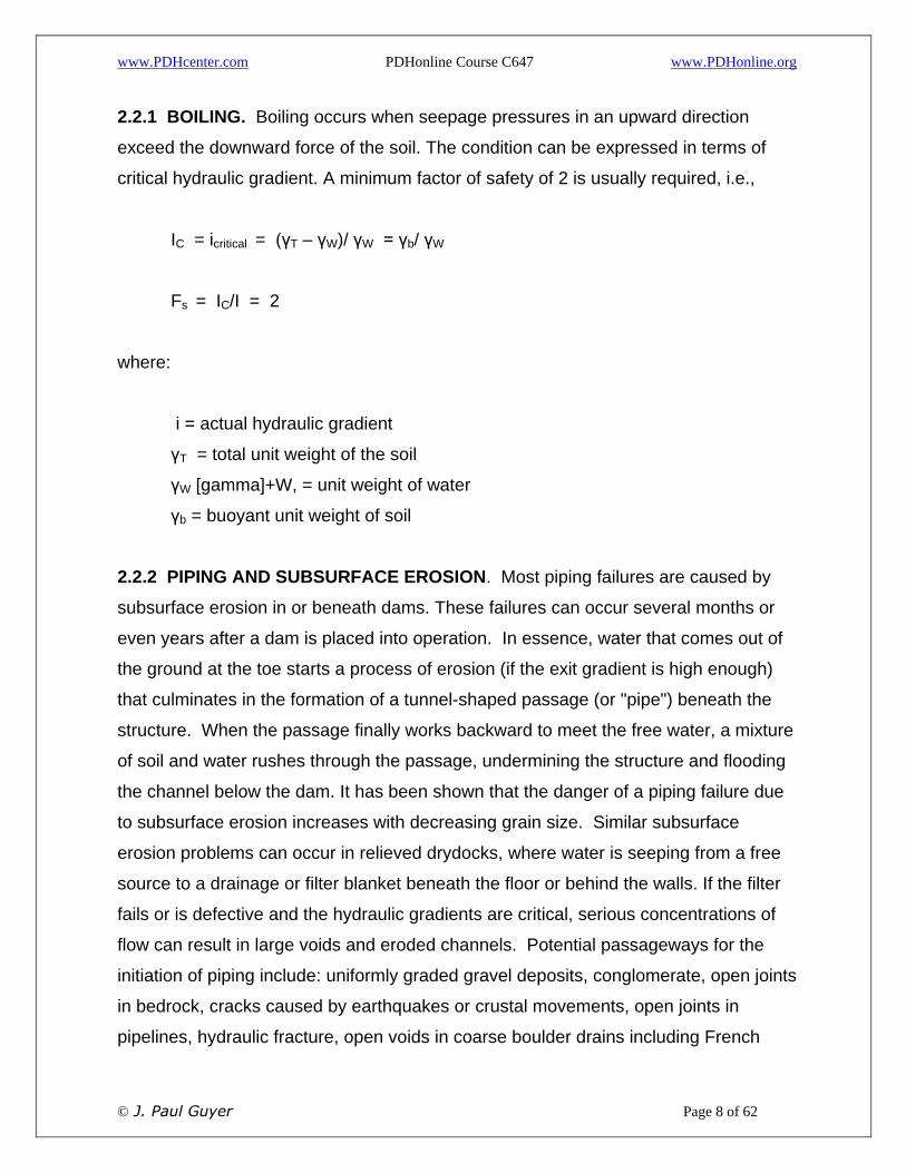
2.2.1 BOILING. Boiling occurs when seepage pressures in an upward direction
exceed the downward force of the soil. The condition can be expressed in terms of
critical hydraulic gradient. A minimum factor of safety of 2 is usually required, i.e.,
IC = icritical = (γT – γW)/ γW = γb/ γW
Fs = IC/I = 2
where:
i = actual hydraulic gradient
γT = total unit weight of the soil
γW [gamma]+W, = unit weight of water
γb = buoyant unit weight of soil
2.2.2 PIPING AND SUBSURFACE EROSION. Most piping failures are caused by
subsurface erosion in or beneath dams. These failures can occur several months or
even years after a dam is placed into operation. In essence, water that comes out of
the ground at the toe starts a process of erosion (if the exit gradient is high enough)
that culminates in the formation of a tunnel-shaped passage (or "pipe") beneath the
structure. When the passage finally works backward to meet the free water, a mixture
of soil and water rushes through the passage, undermining the structure and flooding
the channel below the dam. It has been shown that the danger of a piping failure due
to subsurface erosion increases with decreasing grain size. Similar subsurface
erosion problems can occur in relieved drydocks, where water is seeping from a free
source to a drainage or filter blanket beneath the floor or behind the walls. If the filter
fails or is defective and the hydraulic gradients are critical, serious concentrations of
flow can result in large voids and eroded channels. Potential passageways for the
initiation of piping include: uniformly graded gravel deposits, conglomerate, open joints
in bedrock, cracks caused by earthquakes or crustal movements, open joints in
pipelines, hydraulic fracture, open voids in coarse boulder drains including French

www.PDHcenter.com PDHonline Course C647 www.PDHonline.org
© J. Paul Guyer Page 9 of 62
drains, abandoned wellpoint holes, gopher holes, cavities formed in levee foundations
by rotting roots or buried wood, improper backfilling of pipelines, pipes without
antiseepage collars, etc. Failure by piping requires progressive movement of soil
particles to a free exit surface. It can be controlled by adequately designed filters or
relief blankets. Guidelines for preventing piping beneath dams may be found in
Reference 1, Security from Under Seepage of Masonry Dams on Earth Foundations,
by Lee.

www.PDHcenter.com PDHonline Course C647 www.PDHonline.org
© J. Paul Guyer Page 10 of 62
3. SEEPAGE CONTROL BY CUTOFF.
3.1 METHODS. Procedures for seepage control include cutoff walls for decreasing
the seepage quantity and reducing the exit gradients, and drainage or relief structures
that increase flow quantity but reduce seepage pressures or cause drawdown in
critical areas. See Table 1.
3.2 SHEETPILING. A driven line of interlocking steel sheeting may be utilized for a
cutoff as a construction expedient or as a part of the completed structure.
3.2.1 APPLICABILITY. The following considerations govern the use of sheetpiling:

www.PDHcenter.com PDHonline Course C647 www.PDHonline.org
© J. Paul Guyer Page 11 of 62
Table 1
Cutoff Methods for Seepage Control

www.PDHcenter.com PDHonline Course C647 www.PDHonline.org
© J. Paul Guyer Page 12 of 62
Table 1 (continued)
Cutoff Methods for Seepage Control

www.PDHcenter.com PDHonline Course C647 www.PDHonline.org
© J. Paul Guyer Page 13 of 62
Table 1 (continued)
Cutoff Methods for Seepage Control

www.PDHcenter.com PDHonline Course C647 www.PDHonline.org
© J. Paul Guyer Page 14 of 62
3.2.1.1 SHEETING is particularly suitable in coarse-grained material with maximum
sizes less than about 6 inches or in stratified subsoils with alternating fine grained and
pervious layers where horizontal permeability greatly exceeds vertical.
3.2.1.2 TO BE EFFECTIVE, sheeting must be carefully driven with interlocks intact.
Boulders or buried obstructions are almost certain to damage sheeting and break
interlock connections. Watertightness cannot be assumed if obstructions are present.
3.2.1.3 LOSS OF HEAD across a straight wall of intact sheeting depends on its
watertightness relative to the permeability of the surrounding soil. In homogeneous
fine-grained soil, head loss created by sheeting may be insignificant. In pervious sand
and gravel, head loss may be substantial depending on the extent to which the flow
path is lengthened by sheeting. In this case, the quantity of water passing through
intact interlocks may be as much as 0.1 gpm per foot of wall length for each 10 feet
differential in head across sheeting, unless special measures are taken to seal
interlocks.
3.2.2 PENETRATION REQUIRED. This paragraph and Paragraph "3.2.3" below
apply equally to all impervious walls listed in Table 1. Seepage beneath sheeting
driven for partial cutoff may produce piping in dense sands or heave in loose sands.
Heave occurs if the uplift force at the sheeting toe exceeds the submerged weight of
the overlying soil column. To prevent piping or heave of an excavation carried below
groundwater, sheeting must penetrate a sufficient depth below subgrade or
supplementary drainage will be required at subgrade. See Figure 2 (Reference 2,
Model Experiments to Study the Influence of Seepage on the Stability of a Sheeted
Excavation in Sand, by Marsland) for sheeting penetration required for various safety
factors against heave or piping in isotropic sands. For homogeneous but anisotropic
sands, reduce the horizontal cross-section dimensions by the transformation factor of
Figure 1 to obtain the equivalent cross section for isotropic conditions. See Figure 3
(Reference 2) for sheeting penetration required in layered subsoils. For clean sand,

www.PDHcenter.com PDHonline Course C647 www.PDHonline.org
© J. Paul Guyer Page 15 of 62
exit gradients between 0.5 and 0.75 will cause unstable conditions for men and
equipment operating on the subgrade. To avoid this, provide sheeting penetration for a
safety factor of 1.5 to 2 against piping or heave.
3.2.3 SUPPLEMENTARY MEASURES. If it is uneconomical or impractical to provide
required sheeting penetration, the seepage exit gradients may be reduced as follows:
3.2.3.1 FOR HOMOGENEOUS MATERIALS or soils whose permeability decreases
with depth, place wellpoints, pumping wells, or sumps within the excavation.
Wellpoints and pumping wells outside the excavation are as effective in some cases
and do not interfere with bracing or excavation.
3.2.3.2 FOR MATERIALS WHOSE PERMEABILITY INCREASES WITH DEPTH,
ordinary relief wells with collector pipes at subgrade may suffice.
3.2.3.3 A PERVIOUS BERM placed against the sheeting, or a filter blanket at
subgrade, will provide weight to balance uplift pressures. Material placed directly on
the subgrade should meet filter criteria. Sheeting is particularly suitable in coarse-
grained material with maximum sizes less than about 6 inches or in stratified subsoils
with alternating fine grained and pervious layers where horizontal permeability greatly
exceeds vertical.

www.PDHcenter.com PDHonline Course C647 www.PDHonline.org
© J. Paul Guyer Page 16 of 62
Figure 2
Penetration of Cut Off Wall to Prevent Piping in Isotropic Sand

www.PDHcenter.com PDHonline Course C647 www.PDHonline.org
© J. Paul Guyer Page 17 of 62
Figure 3
Penetration of Cut Off Wall Required to Prevent Piping in Stratified Sand

www.PDHcenter.com PDHonline Course C647 www.PDHonline.org
© J. Paul Guyer Page 18 of 62
Figure 3 (continued)
Penetration of Cut Off Wall Required to Prevent Piping in Stratified Sand

www.PDHcenter.com PDHonline Course C647 www.PDHonline.org
© J. Paul Guyer Page 19 of 62
3.2.4 AN OUTSIDE OPEN WATER SOURCE may be blanketed with fines or
bentonite dumped through water or placed as a slurry. See Table 2. Evaluate the
effectiveness of these measures by flow net analysis.
3.3 GROUTED CUTOFF. Complete grouted cutoff is frequently difficult and costly to
attain. Success of grouting requires careful evaluation of pervious strata for selection
of appropriate grout mix and procedures. These techniques, in combination with other
cutoff or drainage methods, are particularly useful as a construction expedient to
control local seepage.
3.4 IMPERVIOUS SOIL BARRIERS. Backfilling of cutoff trenches with selected
impervious material and placing impervious fills for embankment cores are routine
procedures for earth dams.
3.4.1 COMPACTED IMPERVIOUS FILL. Properly constructed, these sections permit
negligible seepage compared to the flow through foundations or abutments. Pervious
layers or lenses in the compacted cutoff must be avoided by blending of borrow
materials and scarifying to bond successive lifts.
3.4.2 MIXED-IN-PLACE PILES. Overlapping mixed-in-place piles of cement and
natural soil forms a cofferdam with some shear resistance around an excavation.
3.4.3 SLURRY-FILLED TRENCH. Concurrent excavation of a straight sided trench
and backfilling with a slurry of bentonite with natural soil is done. Alternatively, a
cement bentonite mix can be used in a narrower trench where coarser gravel occurs.
In certain cases, tremie concrete may be placed, working upward from the base of a
slurry-filled trench, to form a permanent peripheral wall.

www.PDHcenter.com PDHonline Course C647 www.PDHonline.org
© J. Paul Guyer Page 20 of 62
4. DESIGN OF DRAINAGE BLANKET AND FILTERS
4.1 FILTERS. If water flows from a silt to a gravel, the silt will wash into the
interstices of the gravel. This could lead to the following, which must be avoided:
4.1.1. THE LOSS OF SILT may continue, causing creation of a cavity.
4.1.2 THE SILT MAY CLOG THE GRAVEL, stopping flow, and causing hydrostatic
pressure buildup. The purpose of filters is to allow water to pass freely across the
interface (filter must be coarse enough to avoid head loss) but still be sufficiently fine
to prevent the migration of fines. The filter particles must be durable, e.g., certain
crushed limestones may dissolve. Filter requirements apply to all permanent
subdrainage structures in contact with soil, including wells. See Figure 4 for protective
filter design criteria.

www.PDHcenter.com PDHonline Course C647 www.PDHonline.org
© J. Paul Guyer Page 21 of 62
Figure 4
Design Criteria for Protective Filters

www.PDHcenter.com PDHonline Course C647 www.PDHonline.org
© J. Paul Guyer Page 22 of 62
Figure 4 (continued)

www.PDHcenter.com PDHonline Course C647 www.PDHonline.org
© J. Paul Guyer Page 23 of 62
Design Criteria for Protective Filters

www.PDHcenter.com PDHonline Course C647 www.PDHonline.org
© J. Paul Guyer Page 24 of 62
The filter may be too fine grained to convey enough water, to provide a good working
surface, or to pass the water freely without loss of fines to a subdrain pipe. For this
condition, a second filter layer is placed on the first filter layer; the first filter layer is
then considered the soil to be protected, and the second filter layer is designed. The
finest filter soil is often at the base, with coarser layers above. This is referred to as
reversed or inverted filters. Concrete sand (ASTM C33, Specifications for Concrete
Aggregates) suffices as a filter against the majority of fine-grained soils or silty or
clayey sands. For non-plastic silt, varved silt, or clay with sand or silt lenses, use
asphalt sand (ASTM D1073, Specifications for Fine Aggregates for Bituminous Paving
Mixtures) but always check the criteria in Figure 4. Locally available natural materials
are usually more economical than processed materials, and should be used where
they meet filter criteria. The fine filter layer can be replaced with plastic filter cloths
under the following conditions (after Reference 3, Performance of Plastic Filter Cloths
as a Replacement for Granular Materials, by Calhoun, et al.):
4.1.2.1 NON-WOVEN FILTER CLOTHS, or woven filter cloths with less than 4% open
area should not be used where silt is present in sandy soils. A cloth with an equivalent
opening size (EOS) equal to the No. 30 sieve and an open area of 36% will retain
sands containing silt.
4.1.2.2 WHEN STONES ARE TO BE DROPPED DIRECTLY ON THE CLOTH, or
where uplift pressure from artesian water may be encountered, the minimum tensile
strengths (ASTM D1682, Tests for Breaking Load and Elongation of Textile Fabrics) in
the strongest and weakest directions should be not less than 350 and 200 lbs.
respectively. Elongation at failure should not exceed 35%. The minimum burst
strength should be 520 psi (ASTM D751, Testing Coated Fabrics). Where the cloths
are used in applications not requiring high strength or abrasion resistance, the strength
requirements may be relaxed.
4.1.2.3 CLOTHS MADE OF POLYPROPYLENE, polyvinyl chloride and polyethylene
fibers do not deteriorate under most conditions, but they are affected by sunlight, and

www.PDHcenter.com PDHonline Course C647 www.PDHonline.org
© J. Paul Guyer Page 25 of 62
should be protected from the sun. Materials should be durable against ground
pollutants and insect attack, and penetration by burrowing animals.
4.1.2.4 WHERE FILTER CLOTHS ARE USED TO WRAP COLLECTION PIPES or in
similar applications, backfill should consist of clean sands or gravels graded such that
the D85 is greater than the EOS of the cloth. When trenches are lined with filter cloth,
the collection pipe should be separated from the cloth by at least six inches of granular
material.
4.1.2.5 CLOTHS SHOULD BE MADE OF MONOFILAMENT YARNS, and the
absorption of the cloth should not exceed 1% to reduce possibility of fibers swelling
and changing EOS and percent of open area. For further guidance on types and
properties of filter fabrics see Reference 4, Construction and Geotechnical
Engineering Using Synthetic Fabrics, by Koerner and Welsh.
4.2 DRAINAGE BLANKET. Figure 5 shows typical filter and drainage blanket
installations.
4.2.1 PERMEABILITY. Figure 6 (Reference 5, Subsurface Drainage of Highways, by
Barber) gives typical coefficients of permeability for clean, coarse-grained drainage
material and the effect of various percentages of fines on permeability. Mixtures of
about equal parts gravel with medium to coarse sand have a permeability of
approximately 1 fpm. Single sized, clean gravel has a permeability exceeding 50 fpm.
For approximate relationship of permeability versus effective grain size D+10,, see
Figure 1, Chapter 3.
4.2.2 DRAINAGE CAPACITY. Estimate the quantity of water which can be
transmitted by a drainage blanket as follows:
Q = kiA

www.PDHcenter.com PDHonline Course C647 www.PDHonline.org
© J. Paul Guyer Page 26 of 62
where:
q = quantity of flow, ft3/sec
k = permeability coefficient, ft/sec
i = average gradient in flow direction, ft/ft
A = cross sectional area of blanket, ft2
The gradient is limited by uplift pressures that may be tolerated at the point farthest
from the outlet of the drainage blanket. Increase gradients and flow capacity of the
blanket by providing closer spacing of drain pipes within the blanket.
4.2.2.1 PRESSURE RELIEF. See bottom panel of Figure 7 (Reference 6, Seepage
Requirements of Filters and Pervious Bases, by Cedergren) for combinations of drain
pipe spacing, drainage course thickness, and permeability required for control of flow
upward from an underlying aquifer under an average vertical gradient of 0.4.
4.2.2.2 RATE OF DRAINAGE. See the top panel of Figure 7 (Reference 5) for time
rate of drainage of water from a saturated base course beneath a pavement. Effective
porosity is the volume of drainable water in a unit volume of soil. It ranges from 25
percent for a uniform material such as medium to coarse sand, to 15 percent for a
broadly graded sand-gravel mixture.
4.2.2.3 DRAINAGE BLANKET DESIGN. The following guidelines should be
followed:
GRADATION. Design in accordance with Figure 4.
THICKNESS. Beneath, structures require a minimum of 12 inches for each
layer with a minimum thickness of 24 inches overall. If placed on wet, yielding,
uneven excavation surface and subject to construction operation and traffic,
minimum thickness shall be 36 inches overall.

www.PDHcenter.com PDHonline Course C647 www.PDHonline.org
© J. Paul Guyer Page 27 of 62
Figure 5
Typical Filter and Drainage Blanket Applications

www.PDHcenter.com PDHonline Course C647 www.PDHonline.org
© J. Paul Guyer Page 28 of 62
Figure 6
Permeability and Capillarity of Drainage Materials

www.PDHcenter.com PDHonline Course C647 www.PDHonline.org
© J. Paul Guyer Page 29 of 62
Figure 7
Analysis of Drainage Layer Performance

www.PDHcenter.com PDHonline Course C647 www.PDHonline.org
© J. Paul Guyer Page 30 of 62
4.2.2.4 CHEMICAL CLOGGING. Filter systems (filter layers, fabrics, pipes) can
become chemically clogged by ferruginous (iron) and carbonate depositions and
incrustations. Where the permanent subdrainage system is accessible, pipes with
larger perforations (3/8 inch) and increased thickness of filter layers can be used. For
existing facilities, a weak solution of hydrochloric acid can be used to dissolve
carbonates.
4.3 INTERCEPTING DRAINS. Intercepting drains consist of shallow trenches with
collector pipes surrounded by drainage material, placed to intercept seepage moving
horizontally in an upper pervious stratum. To design proper control drains, determine
the drawdown and flow to drains by flow net analysis. Figure 8 shows typical
placements of intercepting drains for roadways on a slope.
4.4 SHALLOW DRAINS FOR PONDED AREAS. Drains consisting of shallow stone
trenches with collector pipes can be used to collect and control surface runoff. See
Figure 9 (Reference 7, Seepage Into Ditches From a Plane Water Table Overlying a
Gravel Substratum, by Kirkham; and Reference 8, Seepage Into Ditches in the Case
of a Plane Water Table And an Impervious Substratum, by Kirkham) for determination
of rate of seepage into drainage trenches. If sufficient capacity cannot be provided in
trenches, add surface drainage facilities.
4.5 PIPES FOR DRAINAGE BLANKETS AND FILTERS. Normally, perforated wall
pipes of metal or plastic or porous wall concrete pipes are used as collector pipes.
Circular perforations should generally not be larger than 3/8 inch. Filter material must
be graded according to the above guidelines. Pipes should be checked for strength.
Certain deep buried pipes may need a cradle. Check for corrosiveness of soil and
water; certain metal pipes may not be appropriate. Since soil migration may occur,
even in the best designed systems, install cleanout points so that the entire system
can be flushed and snaked.

www.PDHcenter.com PDHonline Course C647 www.PDHonline.org
© J. Paul Guyer Page 31 of 62
5. WELLPOINT SYSTEMS AND DEEP WELLS
5.1 METHODS. Excavation below groundwater in soils having a permeability greater
than 10-3 fpm generally requires dewatering to permit construction in the dry. For
materials with a permeability between 10-3 and 10-5. fpm, the amount of seepage may
be small but piezometric levels may need to be lowered in order to stabilize slopes or
to prevent softening of subgrades. Drawdown for intermediate depths is normally
accomplished by wellpoint systems or sumps. Deep drainage methods include deep
pumping wells, relief wells, and deep sheeted sumps. These are appropriate when
excavation exceeds a depth that can be dewatered efficiently by wellpoint systems
alone or when the principal source of seepage is from lower permeable strata.

www.PDHcenter.com PDHonline Course C647 www.PDHonline.org
© J. Paul Guyer Page 32 of 62
Figure 8
Intercepting Drains for Roadways on a Slope

www.PDHcenter.com PDHonline Course C647 www.PDHonline.org
© J. Paul Guyer Page 33 of 62
Figure 9
Rate of Seepage into Drainage Trench

www.PDHcenter.com PDHonline Course C647 www.PDHonline.org
© J. Paul Guyer Page 34 of 62
5.1.1 CONSTRUCTION CONTROLS. For important construction dewatering, install
piezometers below the base of excavations and behind slopes or cofferdams to check
on the performance and adequacy of drainage system.
5.1.2 SETTLEMENT EFFECTS. Where dewatering lowers the water levels in
permeable strata adjacent to compressible soils, settlement may result.
5.2 WELLPOINT SYSTEMS. Wellpoints consist of 1-1/2 or 2-inch diameter pipes
with a perforated bottom section protected by screens. They are jetted or placed in a
prepared hole and connected by a header pipe to suction pumps.
5.2.1 APPLICABILITY. Wellpoints depend upon the water flowing by gravity to the
well screen. Pumping methods for gravity drainage generally are not effective when
the average effective grain size of a soil D10 is less than 0.05 mm. In varved or
laminated soils where silty fine sands are separated by clayey silts or clay, gravity
drainage may be effective even if the average material has as much as 50 percent
smaller than 0.05 mm. Compressible, fine-grained materials containing an effective
grain size less than 0.01 mm can be drained by providing a vacuum seal at the ground
surface around the wellpoint, utilizing atmospheric pressure as a consolidating force.
See Section 4 for limitations due to iron and carbonate clogging.
5.2.2 CAPACITY. Wellpoints ordinarily produce a drawdown between 15 and 18 feet
below the center of the header. For greater drawdown, install wellpoints in successive
tiers or stages as excavation proceeds. Discharge capacity is generally 15 to 30 gpm
per point. Points are spaced between 3 and 10 feet apart. In finely stratified or varved
materials, use minimum spacing of points and increase their effectiveness by placing
sand in the annular space surrounding the wellpoint.
5.2.3 ANALYSIS. Wellpoint spacing usually is so close that the seepage pattern is
essentially two dimensional. Analyze total flow and drawdown by flow net procedure.
www.PDHcenter.com PDHonline Course C647 www.PDHonline.org
© J. Paul Guyer Page 35 of 62
For fine sands and coarser material, the quantity of water to be removed controls
wellpoint layout. For silty soils, the quantity pumped is relatively small and the number
and spacing of wellpoints will be influenced by the time available to accomplish the
necessary drawdown.
5.3 SUMPS. For construction convenience or to handle a large flow in pervious soils,
sumps can be excavated with soldier beam and horizontal wood lagging. Collected
seepage is removed with centrifugal pumps placed within the sump. Analyze
drawdown and flow quantities by approximating the sump with an equivalent circular
well of large diameter. Sheeted sumps are infrequently used. Unsheeted sumps are
far more common, and are used primarily in dewatering open shallow excavations in
coarse sands, clean gravels, and rock.
5.4 ELECTRO-OSMOSIS. This is a specialized procedure utilized in silts and clays
that are too fine-grained to be effectively drained by gravity or vacuum methods.
5.5 PUMPING WELLS. These wells are formed by drilling a hole of sufficient
diameter to accommodate a pipe column and filter, installing a well casing, and placing
filter material in the annular space surrounding the casing. Pumps may be either the
turbine type with a motor at the surface and pipe column with pump bowls hung inside
the well, or a submersible pump placed within the well casing.
5.5.1 APPLICATIONS. Deep pumping wells are used if (a) dewatering installations
must be kept outside the excavation area, (b) large quantities are to be pumped for the
full construction period, and (c) pumping must commence before excavation to obtain
the necessary time for drawdown. See Figure 10 (bottom panel, Reference 9, Analysis
of Groundwater Lowering Adjacent to Open Water, by Avery) for analysis of drawdown
and pumping quantities for single wells or a group of wells in a circular pattern. Deep
wells may be used for gravels to silty fine sands, and water bearing rocks. Bored
shallow wells with suction pumps can be used to replace wellpoints where pumping is
required for several months or in silty soils where correct filtering is critical.

www.PDHcenter.com PDHonline Course C647 www.PDHonline.org
© J. Paul Guyer Page 36 of 62
5.5.2 SPECIAL METHODS. Ejector or eductor pumps may be utilized within
wellpoints for lifts up to about 60 feet. The ejector pump has a nozzle arrangement at
the bottom of two small diameter riser pipes which remove water by the Venturi
principle. They are used in lieu of a multistage wellpoint system and if the large
pumping capacity of deep wells is not required. Their primary application is for sands,
but with proper control they can also be used in silty sands and sandy silts.
5.6 RELIEF WELLS. These wells are sand columns used to bleed water from
underlying strata containing artesian pressures, and to reduce uplift forces at critical
location. Relief wells may be tapped below ground by a collector system to reduce
back pressures acting in the well.
5.6.1 APPLICATIONS. Relief wells are frequently used as construction expedients,
and in situations where a horizontal drainage course may be inadequate for pressure
relief of deep foundations underlain by varved or stratified soils or soils whose
permeability increases with depth.
5.6.2 ANALYSIS. See Figure 11 for analysis of drawdown produced by line of relief
wells inboard of a long dike. To reduce uplift pressures hm midway between the wells
to safe values, vary the well diameter, spacing, and penetration to obtain the best
combination.

www.PDHcenter.com PDHonline Course C647 www.PDHonline.org
© J. Paul Guyer Page 37 of 62
Figure 10
Groundwater Lowering by Pumping Wells

www.PDHcenter.com PDHonline Course C647 www.PDHonline.org
© J. Paul Guyer Page 38 of 62
Figure 11
Drainage of Artesian Layer by Line of Relief Wells

www.PDHcenter.com PDHonline Course C647 www.PDHonline.org
© J. Paul Guyer Page 39 of 62
6. LININGS FOR RESERVOIRS AND POLLUTION CONTROL FACILITIES
6.1 PURPOSE. Linings are used to reduce water loss, to minimize seepage which
can cause instability in embankments, and to keep pollutants from migrating to
groundwater sources as in holding ponds at sewage treatment and chemical facilities,
and in sanitary landfills.
6.2 TYPES. Table 2 lists types of linings appropriate where wave forces are
insignificant. Where erosive forces are present, combine lining with slope protection
procedure.
6.3 SUBDRAINAGE. If the water level in the reservoir may fall below the surrounding
groundwater level, a permanent subdrainage system should be provided below the
lining.
6.4 INVESTIGATION FOR LINING. Check any potential lining for reaction to
pollutants (e.g., synthetic rubber is subject to attack by hydrocarbons), potential for
insect attack (e.g., certain synthetic fabrics may be subject to termite attack), and the
potential for borrowing animals breaching the lining.

www.PDHcenter.com PDHonline Course C647 www.PDHonline.org
© J. Paul Guyer Page 40 of 62
7. EROSION CONTROL
7.1 GENERAL. The design of erosion controls must consider the volume of runoff
from precipitation, the runoff velocity, and the amount of soil loss.
7.1.1 VOLUME OF RUNOFF. The volume of runoff depends on the amount of
precipitation, ground cover, and topography. For guidance on evaluating the volume of
runoff see Reference 12, Urban Hydrology for Small Watersheds, by the Soil
Conservation Service.
7.1.2 AMOUNT OF SOIL LOSS. Soil losses can be estimated using the Universal
Soil Loss Equation developed by the Soil Conservation Service:
A = EI x (KLS)
where
A = computed soil loss per acre, in tons
EI = rainfall erosion index
K = soil erodibility factor
L = slope length factor
S = slope gradient factor

www.PDHcenter.com PDHonline Course C647 www.PDHonline.org
© J. Paul Guyer Page 41 of 62
Method Applicability and Procedures
Buried Plastic Liner
Impervious liner formed of black colored polyvinyl chloride plastic film. Where foundation is rough or rocky, place a layer 2 to 4 inches thick of fine-grained soil beneath liner. Seal liner sections by bonding with manufacturer's recommended solvent with 6-inch overlap at joints. Protect liner by 6-inch min. cover of fine grained soil. On slopes add a 6-inch layer of gravel and cobbles 3/4 to 3-inch size. Anchor liner in a trench at top of slope. Avoid direct contact with sunlight during construction before covering with fill and in completed installation. Usual thickness range of 20 to 45 mils (.020" to 045"). Items to be specified include Tensile Strength (ASTM D412), Elongation at Break (ASTM D412), Water Absorption (ASTM D471), Cold Bend (ASTM D2136), Brittleness Temperature (ASTM D746), Ozone Resistance (ASTM D1149), Heat Aging Tensile Strength and Elongation at Break (ASTM D412), Strength - Tear and Grab (ASTM D751).
Buried Synthetic Rubber Liner
Impervious liner formed by synthetic rubber, most often polyester reinforced. Preparation, sealing, protection, anchoring, sunlight, thickness, and ASTM standards are same as Buried Plastic Liner.
Bentonite Seal Bentonite placed under water to seal leaks after reservoir filling. For placing under water, bentonite may be poured as a powder or mixed as a slurry and placed into the reservoir utilizing methods recommended by the manufacturer. Use at least 0.8 pounds of bentonite for each square foot of area, with greater concentration at location of suspected leaks. For sealing silty or sandy soils, bentonite should have no more than 10 percent larger than 0.05 mm; for gravelly and rocky materials, bentonite can have as much as 40 percent larger than 0.05 mm. For sealing channels with flowing water or large leaks, use mixture of 1/3 each of sodium bentonite, calcium bentonite, and sawdust.
Earth Lining Lining generally 2 to 4 feet thick of soils having low permeability. Used on bottom and sides of reservoir extending to slightly above operating water levels. Permeability of soil should be no greater than about 2x10
-6 fpm for water supply linings and 2x10
-7
fpm for pollution control facility linings.
Thin Compacted Soil Lining with Chemical Dispersant
Dispersant is utilized to minimize thickness of earth lining required by decreasing permeability of the lining. Used where wave action is not liable to erode the lining. Dispersant, such as sodium tetraphosphate, is spread on a 6-inch lift of clayey silt or clayey sand. Typical rate of application is 0.05 lbs/sf. Chemical and soil are mixed with a mechanical mixer and compacted by sheepsfoot roller. Using a suitable dispersant, the thickness of compacted linings may be limited to about 1 foot; the permeability of the compacted soil can be reduced to 1/10 of its original value.
Table 2
Impermeable Reservoir Linings
EI, L, and S values should be obtained from local offices of the U.S. Soil Conservation
Service. K values may be determined from published data ona particular locality. In the
absence of such data, it may be roughly estimated from Figure 12 (after Reference 13,
Erosion Control on Highway Construction, by the Highway Research Board).

www.PDHcenter.com PDHonline Course C647 www.PDHonline.org
© J. Paul Guyer Page 42 of 62
7.2 INVESTIGATION. Where erosion can be expected during earthwork construction,
on-site investigations should include: (1) field identification and classification for both
agricultural textures and the Unified system, (2) sampling for grain size distribution,
Atterberg limits and laboratory classification, and (3) determination of in-place
densities.
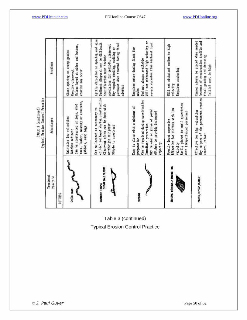
7.3 SURFACE EROSION CONTROL. For typical erosion control practices see Table
3, (modified from Reference 13). General considerations to reduce erosion include:
7.3.1 CONSTRUCTION SCHEDULING. Schedule construction to avoid seasons of
heavy rains. Winds are also seasonal, but are negligible in impact compared to water
erosion.
7.3.2 Soil Type. Avoid or minimize exposure of highly erodible soils. Sands easily
erode but are easy to trap. Clays are more erosion resistant, but once eroded, are
more difficult to trap.
7.3.3 SLOPE LENGTH AND STEEPNESS. Reduce slope lengths and steepness to
reduce velocities. Provide benches on slopes at maximum vertical intervals of 30 feet.
7.3.4 COVER. Cover quickly with vegetation, such as grass, shrubs and trees, or
other covers such as mulches. A straw mulch applied at 2 tons/acre may reduce soil
losses as much as 98% on gentle slopes. Other mulches include asphalt emulsion,
paper products, jute, cloth, straw, wood chips, sawdust, netting of various natural and
man-made fibers, and, in some cases, gravel.
7.3.5 SOIL SURFACE. Ridges perpendicular to flow and loose soil provide greater
infiltration.

www.PDHcenter.com PDHonline Course C647 www.PDHonline.org
© J. Paul Guyer Page 43 of 62
7.3.6 EXPOSED AREA. Minimize the area opened at any one time. Retain as much
natural vegetation as possible. Leave vegetation along perimeters to control erosion
and act as a sediment trap.
7.3.7 DIVERSION. Minimize flow over disturbed areas, such as by placing a berm at
the top of a disturbed slope.
7.3.8 SPRINKLING. Control dust by sprinkling of exposed areas.
7.3.9 SEDIMENT BASINS. Construct debris basins to trap debris and silt before it
enters streams.
7.4 CHANNEL LININGS. Table 4 presents guidelines for minimizing erosion of earth
channels and grass covered channels (modified after Reference 14, Minimizing
Erosion in Urbanizing Areas, by the Soil Conservation Service).

www.PDHcenter.com PDHonline Course C647 www.PDHonline.org
© J. Paul Guyer Page 44 of 62
Figure 12
Nomograph for Determining Soil Erodibility (K)
for Universal Soil Loss Equation

www.PDHcenter.com PDHonline Course C647 www.PDHonline.org
© J. Paul Guyer Page 45 of 62
Table 3
Typical Erosion Control Practice

www.PDHcenter.com PDHonline Course C647 www.PDHonline.org
© J. Paul Guyer Page 46 of 62
Table 3 (continued)
Typical Erosion Control Practice

www.PDHcenter.com PDHonline Course C647 www.PDHonline.org
© J. Paul Guyer Page 47 of 62
Table 3 (continued)
Typical Erosion Control Practice

www.PDHcenter.com PDHonline Course C647 www.PDHonline.org
© J. Paul Guyer Page 48 of 62

www.PDHcenter.com PDHonline Course C647 www.PDHonline.org
© J. Paul Guyer Page 49 of 62
Table 3 (continued)
Typical Erosion Control Practice
www.PDHcenter.com PDHonline Course C647 www.PDHonline.org
© J. Paul Guyer Page 50 of 62
Table 3 (continued)
Typical Erosion Control Practice

www.PDHcenter.com PDHonline Course C647 www.PDHonline.org
© J. Paul Guyer Page 51 of 62
Table 3 (continued)

www.PDHcenter.com PDHonline Course C647 www.PDHonline.org
© J. Paul Guyer Page 52 of 62
Typical Erosion Control Practice
Table 3 (continued)
Typical Erosion Control Practice

www.PDHcenter.com PDHonline Course C647 www.PDHonline.org
© J. Paul Guyer Page 53 of 62
Table 3 (continued)
Typical Erosion Control Practice

www.PDHcenter.com PDHonline Course C647 www.PDHonline.org
© J. Paul Guyer Page 54 of 62
Table 3 (continued)
Typical Erosion Control Practice

www.PDHcenter.com PDHonline Course C647 www.PDHonline.org
© J. Paul Guyer Page 55 of 62
Permissible Velocity (feet/sec)
Soil Type Bare Channel With Channel Vegetation
6” to 10” in height 11” to 24” in height Over 30” in height
Sand, silt, sandy loam, silty loam
1.5 2.0 to 3.0 2.5 to 3.5 3.0 to 4.0
Silty clay loam, silty clay
2.0 3.0 to 4.0 3.5 to 4.5 4.0 to 5.0
Clay 2.5 3.0 to 5.0 3.0 to 5.5 3.0 to 6.0
Table 4
Limiting Flow Velocities to Minimize Erosion
7.5 SEDIMENT CONTROL. Typical sediment control practices are included in
Table 3.
7.5.1 TRAPS. Traps are small and temporary, usually created by excavating and/or
diking to a maximum height of five feet. Traps should be cleaned periodically.
7.5.2 PONDS.
7.5.2.1 SIZE THE OUTLET STRUCTURE to accept the design storm.
7.5.2.2 SIZE THE POND LENGTH, WIDTH AND DEPTH to remove the desired
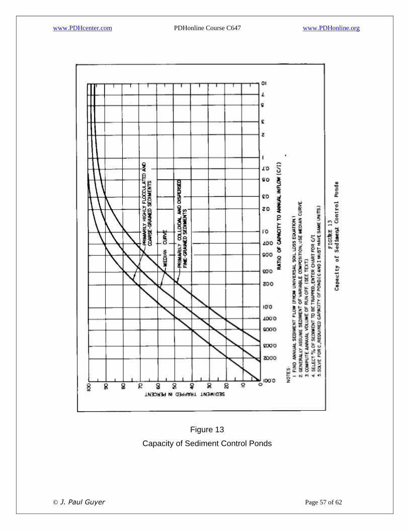
percentage of sediment. See Figure 13 (modified after Reference 15, Trap Efficiency
of Reservoirs, by Brune). For design criteria see Reference 16, Reservoir
Sedimentation, by Gottschalk.
7.5.2.3 IF POND IS PERMANENT, compute volume of anticipated average annual
sedimentation by the Universal Soil Loss Equation. Multiply by the number of years
between pond cleaning and by a factor of safety. This equals minimum required
volume below water level. Dimensions of the pond can then be calculated based on
the available area. The design depth of the pond should be approximately three to five
feet greater than the calculated depth of sediment at the time of clearing.

www.PDHcenter.com PDHonline Course C647 www.PDHonline.org
© J. Paul Guyer Page 56 of 62
7.6 RIPRAP PROTECTION. Frequently coarse rock is placed on embankments
where erodible soils must be protected from fast currents and wave action. When
coarse rock is used, currents and waves may wash soil out from under the rock and
lead to undermining and failure. Soil loss under rock slopes can be prevented by the
use of filter fabrics or by the placement of a filter layer of intermediate sized material
between the soil and rock. In some cases soil loss can be prevented by the use of
well-graded rock containing suitable fines which work to the bottom during placement.
For further guidance see Reference 17, Tentative Design Procedure for Rip Rap Lined
Channels, by the Highway Research Board. For determining rock sizes and filter
requirements use Figure 14 (Reference 18, Design of Small Dams, by the Bureau of
Reclamation).
www.PDHcenter.com PDHonline Course C647 www.PDHonline.org
© J. Paul Guyer Page 57 of 62
Figure 13
Capacity of Sediment Control Ponds

www.PDHcenter.com PDHonline Course C647 www.PDHonline.org
© J. Paul Guyer Page 58 of 62
Example Calculation Annual soil loss in watershed = 0.9 acre-feet/year (from Universal Soil Loss Equation or other method, i.e. design charts) Desired pond efficiency = 70% or 0.63 acre-feet of sediment trapped each year. Annual volume of runoff from watershed draining into proposed pond = 400 acre-feet/yr. For 70% efficiency using median curve C/I = 0.032 Required pond capacity C = 0.032 x 400 = 12.8 acre-feet. Assuming average depth of pond of 6 ft, required pond area about 2.1 acres. Pond should be cleaned when capacity reduced 50%. (Note: Trap efficiency decreases as volume of pond decreases; this has not been considered in the example.) Volume available for sediment = 50% x 12.8 = 6.4 acre-feet. Years between cleaning = 6.4/0.63 = approximately 10 years
________________________________________________
Figure 13 (continued)
Capacity of Sediment Control Ponds

www.PDHcenter.com PDHonline Course C647 www.PDHonline.org
© J. Paul Guyer Page 59 of 62
Figure 14
Design Criteria for Riprap and Filter on Earth Embankments

www.PDHcenter.com PDHonline Course C647 www.PDHonline.org
© J. Paul Guyer Page 60 of 62
_______________________________________________________
FILTER MAY NOT BE REQUIRED IF EMBANKMENT CONSISTS OF CH OR CL WITH LL) 30, RESISTANT TO SURFACE EROSION. IF A FILTER IS USED IN THIS CASE IT ORDINARILY MEETS FILTER CRITERIA AGAINST RIPRAP ONLY. IF EMBANKMENT CONSISTS OF NONPLASTIC SOILS WHERE SEEPAGE WILL MOVE FROM EMBANKMENT AT LOW WATER, 2 FILTER LAYERS MAY BE REQUIRED WHICH SHALL MEET FILTER CRITERIA AGAINST BOTH EMBANKMENT AND RIPRAP. (EXAMPLE IS SHOWN ABOVE).
MINIMUM THICKNESS OF SINGLE LAYER FILTERS ARE AS FOLLOWS
MAXIMUM WAVE HEIGHT, FEET
FILTER THICKNESS, INCHES
DOUBLE FILTER LAYERS SHOULD BE AT LEAST 6 INCHES THICK
0 TO 4 6
4 TO 8 9
8 TO 12 12
_______________________________________________________
Figure 14 (continued)
Design Criteria for Riprap and Filter on Earth Embankments

www.PDHcenter.com PDHonline Course C647 www.PDHonline.org
© J. Paul Guyer Page 61 of 62
8. REFERENCES
1. Lee, E. W., Security from Under Seepage of Masonry Dams on Earth Foundations, Transactions, ASCE, Volume 100, Paper 1919, 1935.
2. Marsland, A., Model Experiments to Study the Influence of Seepage on the Stability of a Sheeted Excavation in Sand, Geotechnique, 1952-1953.
3. Calhoun, C. C., Jr., Compton, J. R., Strohm, W. E. Jr., Performance of Plastic Filter Cloths as a Replacement for Granular Materials, Highway Research Record Number 373, Highway Research Board, 1971.
4. Koerner, R. M. and Welsh, J. P., Construction and Geotechnical Engineering Using Synthetic Fabrics, John Wiley & Sons, Inc., 1980.
5. Barber, E. W., Subsurface Drainage of Highways, Highway Research Board Bulletin 209, Highway Research Board, Washington, D.C.
6. Cedergen, H. R., Seepage Requirements of Filters and Pervious Bases, Journal of the Soil Mechanics and Foundation Division, ASCE, Vol. 86, No. SM5, 1960.
7. Kirkham, D., Seepage Into Ditches From a Plane Water Table Overlying a Gravel Substratum, Journal of Geophysical Research, American Geophysical Union, Washington, D.C., April, 1960.
8. Kirkham, D., Seepage Into Ditches in the Case of a Plane Water Table and an Impervious Substratum, Transactions, American Geophysical Union, Washington, D.C., June, 1950.
9. Avery, S. B., Analysis of Groundwater Lowering Adjacent to Open Water,Proceedings, ASCE, Vol 77, 1951.
10. Corps of Engineers, Soil Mechanics Design, Seepage Control, Engineering Manual, Civil Works Construction, Chapter I, Part CXIX, Department of the Army.
11. Cold Regions Research and Engineering Laboratory, Wastewater Stabilization Pond Linings, Special Report 28, Department of the Army, November, 1978.
12. Soil Conservation Service, U. S. Department of Agriculture, Urban Hydrology for Small Watersheds, Technical Release No. 55, Engineering Division, 1975.
13. Highway Research Board, Erosion Control on Highway Construction, National Cooperative Highway Research Program, Synthesis of Highway Practice 18, 1973.
14. Soil Conservation Service, U. S. Department of Agriculture, Minimizing Erosion in Urbanizing Areas, Madison, WI, 1972.
15. Brune, G. M., Trap Efficiency of Reservoirs, Transactions, American Geophysical Union, Volume 34, No. 3, June, 1953.
16. Gottschalk, L. C., Reservoir Sedimentation, Handbook of Applied Hydrology, Chow, Ed., Section 17-I, McGraw-Hill Book Company, 1964.

www.PDHcenter.com PDHonline Course C647 www.PDHonline.org
© J. Paul Guyer Page 62 of 62
17. Highway Research Board, Tentative Design Procedure for Rip-Rap – Lined Channels, National Cooperative Highway Research Program Report 108, Washington, DC, 1970.
18. Bureau of Reclamation, Design of Small Dams, U.S. Department of the Interior, U. S. Government Printing Office, 1973.
19. Naval Facilities Engineering Command, Design Manuals (DM) and Publications (P).
DM-5.03 Drainage Systems
DM-21.06 Airfield Pavement Design for Frost Conditions and Subsurface Drainage
P-418 Dewatering and Groundwater Control