an introduction to the ballyhoura peter robinson assisted emigration project
TRANSCRIPT

This is a joint presentation by Dr Paul MacCotter & John Tierney
Outlining a genealogical tourism project currently underway with Ballyhoura Developmet Ltd, and funded by the Emigrant Support Fund.

John Tierney is a field archaeologist with 30 years experience. Secretary of our local heritage group in Ardmore, Waterford formerly secretary of Ardmore GAA where i got the equivalent of a Phd in rural community development.
Dr. Paul MacCotter, MA, Ph.D teaches genealogy, family history, and medieval history in University College Cork and the University of Limerick. Since 1993 he has published widely in the fields of Genealogy, Family History, Medieval History, History of Government and Church History.

John Tierney works with Eachtra Archaeological Project who apply archaeological methods to community heritage & genealogy projects with www.historicgraves.com and www.thememorytrail.com.
Eachtra are highly digital in their excavation & post-excavation methodologies which has developed a strong skillset in managing geolocated digital datasets and the lessons we lhave leanred on alrge excacation projects have been applied to community heritage & digital publication.

All site registers on an excavation are linked to the consultation map. All site data is digitised during the excavation. – postex starts during the ex. We geolocate objects with cm’s accuracy – we use this same approach to map headstones in a graveyard or homesteads in a street or townland.

Behind it all are simple spreadsheets – if you can fill out a spreadsheet you can make a geodatabase. Simple spreadsheets are at the centre of all of our projects.

Some of the key questions we are dealing with on the Peter Robinson Assisted Emigration Project

We work with community groups.

Here we see a Ballyhoura team surveying in Liscarroll. Teamwork is what makes the survey projects so enjoyable –working with neighbours to solve a multiplicity of puzzles within a tight deadline.
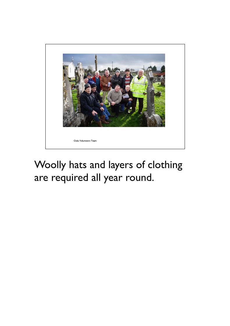
Woolly hats and layers of clothing are required all year round.

Kilbehenny)–gravestones)are)significant)in)genealogical)tourism)because)they)contain)forename,)surname,)placename)and)date)–)they)are)historic)documents)carved)in)stone.)

Gravestone)recording)is)done)in)pairs)–)aiming)for)a)high)quality)product.)

We attach names to places in the landscape - we are geolocating digital heritage - new paradigm for publication & communication. By gelocating everything we make it easier for visitors to find places despite the maze of boreens which often lead to the graveyard or homestead.

Our main website is www.historicgraves.comIt is a powerful multimedia content management system, based on Drupal which is freely available on the web, thus allowing communities to publish their own data without major costs.

Distribution map of the community surveyed graveyards - there are over 700 graveyards online in the system, surveyd and published by over 400 community groups in 5.5 years.We are also working on projects in the UK. And no surprise communities in the UK are very similar to Irish communities.

Here we see the distribution of graveyards in Limerick.

Due to the support of rural development funding bodies such as Bayhoura Development Ltd we have surveyed over 70% of all graveyards in Co. Limerick.

Drape a blanket over the top of a headstone and in the resulting shade a flashlamp can be used to decipher even the most difficult epitaphs.
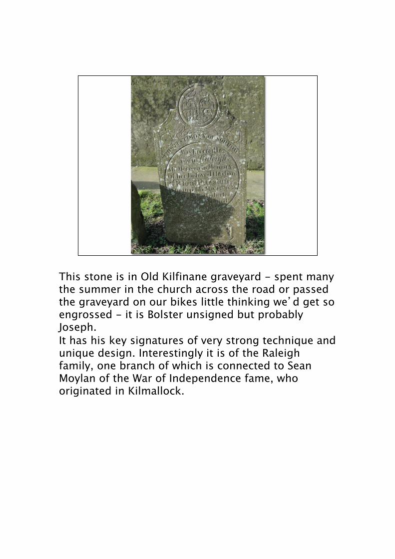
This stone is in Old Kilfinane graveyard - spent many the summer in the church across the road or passed the graveyard on our bikes little thinking we�d get so engrossed - it is Bolster unsigned but probably Joseph.It has his key signatures of very strong technique and unique design. Interestingly it is of the Raleigh family, one branch of which is connected to Sean Moylan of the War of Independence fame, who originated in Kilmallock.

Some are simple in shape and very simply inscribed. All such stones are worth examining as we have found faint initials inscribed as well as crosses.

Cheaper materials in the early 20th century have meant headstones have become more affordable - these three concrete headstones from Brigown in Mitchelstown are typical - often made from a wooden form which means they are found repeated in the same and adjacent graveyards.We have anecdotal accounts of such headstones being made for neighbours and friends - so social networks may be detectable from gravestones.And the key point is that families who were not previously traceable in graveyards have now become visible. We can investigate class & social status with our graveyard surveys.

How to survey a graveyard

Our system is designed to survey a graveyard completely - the average rural graveyard has 100-200 headstones. Each headstone is equally important and all are treated the same.
These are the three simple steps involved

Before surveying the graveyard we must first understand the geography of the place. Historic graveyards are organised as a compass on the landscape – most churches will be oriented W-E and the headstones will mostly face east. East facing headstones & reuse of family graves results in the formation of N-S rows in the graveyard.Also most graves measure 3ft wide - this rule of thumb makes it surprisingly easy to do a sketch plan with some practice.

Simply put, we number each grave memorial with masking tape and a marker.We then take one geotagged photo of each memorial in numbered sequence and upload this to the website.Instant publication is highly engaging for our volunteer groups – theys ee immediate results for their work.
The geotagged grave memorial photo is then a hook that we can hang other media (audio and video stories) onto. We have become geolocated heritage media content publishers. Local people do the surveys, tell their stories and publish them to the web.
As well as hi-tech tools like GPS cameras and audio recorders we depend on simple rolls of masking tape and markers. The tape is used to put a number on the back of each grave memorial. This usually stays on for a week or two and is removed by the community when they are done. If the labels are washed off they are simple to replace. An average graveyard of 89headstones can be renumbered in less than an hour.

The whole enterprise relies on a simple role of masking tape which we use to number each grave memorial (average Irish rural graveyard has 89 headstones)

This slide demonstrates our key technique for reading headstones -we use a single led Lenser P7 torch - aim for 200 lumens or greater than 3 million candle power. Anything less powerful will be a disappointment - so our advice for all graveyard researchers is get the lenser P7 - if gran or grandad has a birthday coming up forget about the jumper or socks- get everybody to box together and buy a P7 lenser.

All of the records are compiled into The Graveyard Folder which is kept locally. This is the paper archive that complements the digital archive which is published online.


Online resourcesWebsiteshttp://www.sehs.on.ca/publications.htmhttp://trentvalleyarchives.com/http://www.peterborough.library.on.ca/http://trentvalleyarchives.com/genealogy/peter-robinson-ships-list/http://www.geni.com/projects/Irish-Peter-Robinson-Settlers-Canada/2553http://www.canada411.ca/search/?stype=si&what=Swytzer&where=Emily%2C+Ontario%2C+Canadahttp://digitalcollections.nypl.org/search/index?filters%5BphysicalLocation_mtxt_s%5D%5B%5D=Map+Division&keywords=&sort=dateDigitized_dt+deschttp://www.canada411.ca/map/mapSearch.html?layers=dir&to=719+Emily+St+Hanmer+ON+P3P+1E4&what=Swytzer&where=Emily%2C+Ontario%2C+Canada&lid=202900442http://search.ancestry.co.uk/cgi-bin/sse.dll?db=canadianbc&so=2&pcat=40&gss=angs-c&new=1&rank=1&msT=1&gsfn=Tobias&gsfn_x=0&gsln=Switzer&gsln_x=0&msbpn__ftp=Ontario%2c+Canada&msbpn=5007&msbpn_PInfo=5-%7c0%7c1652393%7c0%7c3243%7c0%7c5007%7c0%7c0%7c0%7c0%7c&cpxt=1&cp=3&MSAV=1&uidh=i41


In the early 19th century the British government came up with a plan to fund assisted emigration programs for Irish people who were desperate. Peter Robinson was selected to lead one of the earliest expeditions. The advertisement which proclaimed the emigration scheme stated categorically that only a limited number of Settlers would be chosen to emigrate to Upper Canada.Most of the emigrants were chosen from the area north of the Blackwater River in Cork from the estates of 3 key landlords though a number of Kinsellas, from the southeast of Ireland, also went. Eight land owners chose 239 families with 37 other landowners picking the remaining 68 families. Emigrants were required to be peasants, and Roman Catholic although several Protestant families were chosen. No person over the age of 45 would be accepted. Each emigrant was to be given 70 acres which would be subject to a payment of an annual quit rent to the Crown, to be paid every six months at 2 pence per acre. In “The Peter Robinson Settlement of 1825�, author Bill LaBranche says, “In the year 1823 Robinson was to lead an emigration from poverty stricken Ireland to Canada bringing over 182 families in that same year, Robinson opened and settled much of the Ottawa Valley. By May, 1825, the problem had not resolved itself and once again, Robinson, as Superintendent, hustled his Settlers onto the nine ships that awaited them. A total of 2,024 people were crowded onto those nine ships causing ships fever which resulted in several deaths during the voyage.”The families, over two thousand in total settled in 6 townships throughout the

The graveyards currently gathered in the Peter Robinson group are found here;
http://historicgraves.com/project/graveyards-ballyhoura-peter-robinson-assisted-emigration-project

We aim to add the relevant Canadian graveyards and cemeteries to the database.
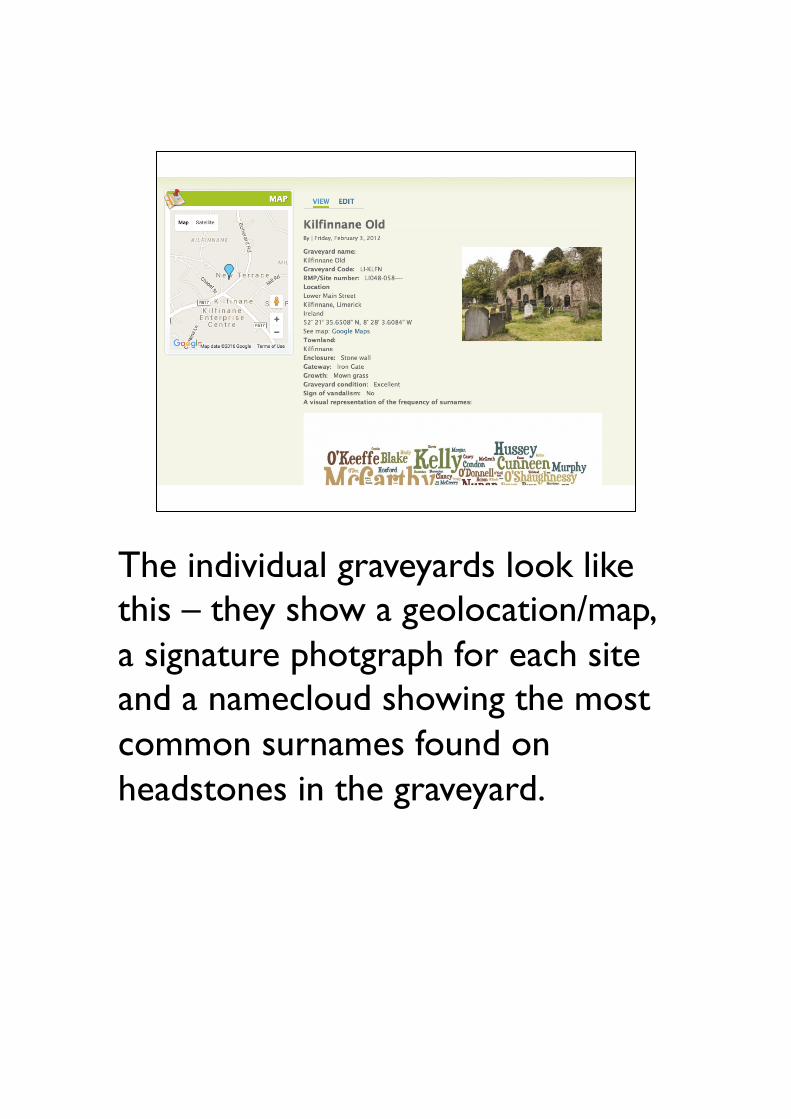
The individual graveyards look like this – they show a geolocation/map, a signature photgraph for each site and a namecloud showing the most common surnames found on headstones in the graveyard.

We conduct full surveys of each graveyard. We aim for every headstone in every graveyard in a parish – in this way we can make it easier for the Canadian genealogists to trace their forebears ancestral graveyards.

Old Kilfinane Namecloud –the larger the name the more frequently it is found on the Kilfinane gravestones

Compared with the Namecloud for the first ship to sai in 1823l The Hebe


Background to the Peter Robinson Assisted Emigration

The type of records available for Paul macCotter to commence his research – the challenge in this case is can Paul identify Ceileachair’s/Kelchers/Kellehers to more than Dingle?

By checking records of births, deaths and marriages from the early 19th century Paul has been able to trace about 10% of the passengers to townland level.

In this case a member of the local community has already commenced research on the Doherty’s of Curraghavoe and will work together with the research team.

About a quarter of all Peter Robinson families can be traced to a parish, and 10% to a townland. The project will continue to publish these new results to thememorytrail.com thus building an important geolocated genealogical database.The project is also building a system for tracing and recording the places associated with the families of the Irish diaspora who emigrated in the 19th/early 20th centuries.

We first looked at some historical sources for the occupants of Ballydonohue in the early 1800s and then traced the changes in families throughout the 19th century.


We are faced with a confusion of maps – this is the earliest version of the Griffiths Valuation map –date 1850. We use this map to pin the locations of families from 1850 onwards – hoping at least some families held the same lands in the century before 1850. We cannot predict the results of this survey and aim to work with community groups to determine the levels of dynamism in landholding in the 18th & 19th centuries.

As well as recording geolocated records of the Peter Robinson families’ burial places on historicgraves.com we have also started to try and trace the homesteads of those families at
http://thememorytrail.com/content/ballyhoura-peter-robinson-assisted-emigration-project
We are working with community groups elsewhere in ireland to record other emigration events from rural townlands to streets in Dublin. Any groups wishing to work with us on this type of project please email [email protected].

This is a clothe map available in the Valuations Office in Dublin showing landholding plots in Ballydonohue in 1871. The plot numbers on this correspond to Cancel Books which are handwritten lists of landowners and tenants where the succession of tenants is indicated in coloured ink.

We will plot these Valuation records to the townlands they relate to. Here is the plot for Ballydonohue.
http://thememorytrail.com/group/ballydonohue-griffiths-valuation-properties-1850-onwards
This geolocated dataset can be explored with any gps enable device and web browser.

Here we see Paul’s pre-1850s research identifying the Cleary family hold the land in 1828 to be succeeded by the Courtneys in the 1850s. The red pin on the map shows that this is a geolocated dataset – using that pin any tourist/visitor can easily find this field, without any local knowledge at all –simply open the site in your smartphone and use it’s satnav to drive you there.

Plot 2 is associated with the Cleary and Fenton families.

The Connor’s and Fenton’s farmed plot 3a/7a. This same property is an important tourism site today where schoolbuses visit on a regular basis to explore an Irish dairy farm.

The live map on thememorytail.com showing the three historic properties on a google map background.

Using thememorytrail.com we are in the process of publishing the key people, palces and events involved in the Peter Robinson Assisted Emigration.Together building up a geolocated genealogical database.
We add Data first and Stories second.
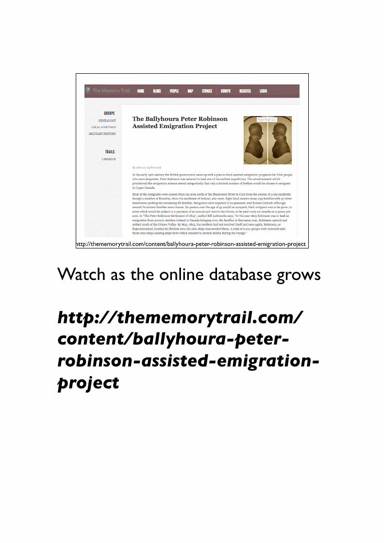
Watch as the online database grows
http://thememorytrail.com/content/ballyhoura-peter-robinson-assisted-emigration-project

All of the data will be organized into logical groups.

We will also include groups of geolocated Canadian data – we know the approx 2000 emigrants went to 7 townships in Ontario.

One data group will identify the passengers on each ship –their familial relations and allow descendants to add information to the website. This pages shows the data entry for the Armstrong family from Kilfinane who sailed on the Hebe.

Using a gps enabled smartphone to track a genealogical dataset in Collins Barracks Dublin. Augmented reality software like layar.com can also be used to explore the datasets and will publish the Peter Robinson data in layar in late Spring.

This project is being run as a pilot to build a methodology for making the past a place.The methods we develop can also be used to investigate the broader emigration events of the 19th century.We are actively seeking partners with links on the other side of the pond who will be interested in surveying headstones and homesteads/