an investigation into the cause of road failure along
TRANSCRIPT

RESEARCH Open Access
An investigation into the cause of roadfailure along Sagamu-Papalanto highwaysouthwestern NigeriaUbido Oyem Emmanuel*, Igwe Ogbonnaya and Ukah Bernadette Uche
Abstract
Investigation into the cause of road failure has been carried out along a 60 km long Sagamu –Papalanto highwaysouthwestern Nigeria. Geochemical, mineralogical, geotechnical and geophysical analyses were conducted toevaluate the cause of failure along the study area. The results of the laboratory tests showed that the percentageamount of fines ranges from 12 to 61.3%, natural moisture content from 6.8 to 19.7%, liquid limit in the range of25.1–52.2%, linear shrinkage between 3.96 to 12.71%, plastic limit ranges from 18.2–35%, plasticity index rangesfrom 5.2 to 24.6%, free swell in the range from 5.17–43.9%, maximum dry density ranges from 1.51–1.74 g /cm3,specific gravity ranges from 2.52–2.64 and CBR between 3 and 12%. The Cone Penetrometer Test (CPT) shows aresistance value of 20–138 kgf/cm2. The major clay mineral that is predominant in the studied soil is kaolinite. Themajor oxides present are SiO2, Al2O3, Fe2O3, K2O, Na2O, MgO and CaO. The result of the 2D Electrical ResistivityImaging revealed a low resistivity values for profile 2 and 3 ranging from 100 Ωm – 300 Ωm, between a distance of20 m – 240 m along the profile to a depth of 7.60 m and a low resistivity value ranging from 50 Ωm – 111Ωm,between a distance of 80 m − 120 m along the profile to a depth of 15 m. It was concluded that the low CBR, lowMDD and the class of subsoils namely A-26, A-7, A-2-7 (clayey soils) which were identified are responsible for thecause of failure experienced in the study area. These makes the soils unsuitable as road construction materials andhence, there is need for stabilization during the reconstruction and rehabilitation of the road.
Keywords: Disaster, Road, Failure, Soil, Liquid limit, Plastic limit, Geophysical investigation
IntroductionRoad transportation is of paramount importance toevery society and country. It dictates the pace of socio-economic development in any country. It is worthy tonote that no economy can thrive where there is no goodroad. However, roads play an important role to theincrease of any country gross domestic product. There isa positive correlation that exist between a country’seconomic growth and the standard of its road network.A country roads network should be designed and con-structed in a systematic manner that the intended social
cultural and the economic benefits can be maximized(Ighodalo 2009).It is of importance to highlight that Nigeria roads have
often being characterized with long cracks, potholes andother pavement defects. These has posed a seriouschallenge and disaster such that in Nigeria one canhardly travel a kilometer without coming across a longcracks and potholes. These has resulted to a spike in thenumber of road accidents and a plunge on the nation’seconomic development. Every single road built are oftenknown to have a stipulated design life; but roads oftentimes fail long before the planned expected date; somefail after construction, some after flooding while otherslast to its entire life expectancy with appropriatemaintenance.
© The Author(s). 2021 Open Access This article is licensed under a Creative Commons Attribution 4.0 International License,which permits use, sharing, adaptation, distribution and reproduction in any medium or format, as long as you giveappropriate credit to the original author(s) and the source, provide a link to the Creative Commons licence, and indicate ifchanges were made. The images or other third party material in this article are included in the article's Creative Commonslicence, unless indicated otherwise in a credit line to the material. If material is not included in the article's Creative Commonslicence and your intended use is not permitted by statutory regulation or exceeds the permitted use, you will need to obtainpermission directly from the copyright holder. To view a copy of this licence, visit http://creativecommons.org/licenses/by/4.0/.
* Correspondence: [email protected] of Physical Sciences, Department of Geology, University of Nigeria,Nsukka Enugu state, Nsukka, Nigeria
Geoenvironmental DisastersEmmanuel et al. Geoenvironmental Disasters (2021) 8:3 https://doi.org/10.1186/s40677-020-00174-8

Highway pavements and foundation soils are insepar-able duo toward the development of any country(Meshida 2006; Olofinyo et al. 2019). Diverse road fail-ure components are observable within a short period oftime after commissioning. Roads are literally constructedon geologic materials and these materials’ properties im-pact their functioning as transport medium (Gupta andGupta 2003; Olofinyo et al. 2019). The major compo-nents of several typical flexible highway pavements fromthe base to the top include the subgrade, sub-base, basecourse and riding surfaces (Gupta and Gupta 2003;Adeyemi 2013). However, loss of lives and propertieshas been linked to the poor design and substandard con-struction activities arising from non- compliance withthe recommended standards. However, road failures areusually followed by the following signs such as rutting,potholes, differential heave, deformation, peeling andcracking (Gidigasu 1976; Alexander and Maxwell 1996).Several factors have been linked to the increasingrecorded road failures include geomorphological, geo-logical and geotechnical factors, design and constructioninadequacies, maintenances and road usage (Oke et al.2009; Nwankwoala et al. 2014). Climatic factors in par-ticular temperature alterations and attacks by acid rainhave been reported to reduce the performance of theroad base materials. Gidigasu (1983) and Graham andShields (1984) reported insufficient width and themakeup of the road shoulders as other contributing fac-tors that give rise to road failure. Specifically, severalpavement failures in the Southern region and NigerDelta region of Nigeria have been traced to hydrogeo-logical and geological conditions linked with swampy,textural properties of the subsoils and poor drainagemeasures (Jegede 1997; Abam et al. 2005). The preva-lence of pavement failures has also been attributed tothe engineering characteristics of the underlying geologyand the subgrade materials. The engineering characteris-tics of the underlying geology have been reported tohave been controlled by their mineralogical composi-tions (Akpan 2005; Amadi et al. 2012). Poor geotechnicalcharacteristics of the soils such as poor bearing capacity,low maximum dry density, high liquid limit, plasticityindex, optimum moisture content, California bearing ra-tio and high compressibility are typically responsible forroad failures (Akpan 2005; Ademilua 2018). These statesoften result to pavement failures in the shape of crackedpavements and surface deformation. However, the ap-propriateness of soils as base course or subbase courseand the subgrade are in cogent connection to theconveyance and bearing of axle load which determinethe strength, durability and life of roads (Jegede and Olaleye2013; Nwankwoala and Amadi 2013). Geotechnical assess-ment of subsoils helps in comprehending the behaviour ofthe soils that can cause remarkable impairment to road
construction and also propose solutions in problemsconnected with both expansive and unexpansive soils(Daramola et al. 2015; Amadi et al. 2015). Past investiga-tions have also emphasized the role of geophysical investi-gations and integrated geotechnical and geophysicalinvestigations in the investigation of the significant factorsresponsible for ceaseless highway pavement failures in partsof southern Nigeria (Salami et al. 2012; Adeyemi 2013).Sagamu-Papalanto highway is one of the busiest high-
ways in southwestern Nigeria. This is as a result of thepresence of some notable industries in the area. Theroad under investigation is an access route to theLafarge cement company at Ewekoro, Dangote cementcompany at Ibese, NNPC gas plant station at Oloruun-gosho in Ogun state. The bad state of the road has slo-wed down the pace of socio-economic development andactivities in and around the area and its suburbs.The objective of this study is to determine the engin-
eering geological properties of the soils in the study areausing integrated geotechnical and geophysical investiga-tions and their contribution to road failure.
Study areaThe study area lies within Longitude 3°11′35.627″E to3°34′42.25″E and Latitude 6°51′1.217″N to 6°54′16.457″N on the 60 km long Sagamu –Papalantoexpressway in Ogun State Southwestern Nigeria (Fig. 1).The area has a wide spread humid tropical climatemarked by the alternating wet and dry seasons. The wetseason starts in April and ends in October whereas thedry season runs from October to March. The mean an-nual rainfall is approximately 1375 mm. The mean yearlytemperature varies from 22 °C in wet season mean to30 °C in dry season. The humidity ranges from 40% inDecember to 80% in July (Balogun 2003). The study areahas moist air that comes from the Atlantic Oceanthroughout the year. The relief is moderately, unevenand undulating. The area is predominated by dendriticdrainage pattern which implies a quite similar resistanceof the underlying rocks to weathering. Sagamu-Papalanto study area is enclosed in the north by Oyoand Osun States, in the south by Lagos State in the eastby Ondo State and in the west by Benin Republic. Thestudy area belongs to the Ewekoro Formation which isTertiary formed during the Paleocene and Eocene period(Ako et al. 1980; Omatsola and Adegoke 1981; Okosun1990). The studied area is located on the sedimentaryFormation of the south western Nigeria and it is under-lain by the basement complex Adegoke et al. (1976).The geology of the area comprises of sedimentary unitswhich consists of argillaceous sediment which is soft andfriable and some siliceous and ferruginous materials (Fig. 1).The surface soils in the study area are residual lateritic mate-rials composed of greyish to reddish brown, loose medium
Emmanuel et al. Geoenvironmental Disasters (2021) 8:3 Page 2 of 19

to coarse grained mineral matters with some clayey mate-rials. The soils are however dark in colour in areas with vege-tation cover probably as a result of decomposing flora andfauna.
Materials and methodsVisual inspection and reconnaissance survey were under-taken in the course of the fieldwork on February 2–February102,020, to evaluate and access the physical conditions of thehighway pavements. The underlying rocks were identified
and their structural trends were noted. Twenty disturbed soilsamples were collected using an auger from the subgrade,subbase and base course. The materials were taken along theroad sides adjacent to the failed sections in such a mannerthat the soil samples represent the different topo-graphic condition of the road alignment. The samplescollected were sent to the Lagos state material testinglaboratory Nigeria for geotechnical analyses.Electrical Resistivity Imaging (ERI) was implemented
during the investigation. It is a geo-electrical technique
Fig. 1 Map of Nigeria and Geology of the Study Area
Emmanuel et al. Geoenvironmental Disasters (2021) 8:3 Page 3 of 19

used in acquiring a high-level resolution (2D) image ofthe earth surface using the Wenner array electrical con-figuration. The materials used include ABEM terra meterSAS 1000, measuring tape, masking tape, hammers elec-tric, cable steel electrode, RES2DINV software, Global Po-sitioning Satellite (GPS). The Wenner array method wasused in the investigation. A spacing of 25m, 35m, 45m,55m, 65m, 75m, 85m, 95m, 105m long stretch wasemployed. Traverse I, II III and IV were set -up laterallyalong the road profile that shows serious cracks and bab-bling of the pavement. Contrasting electrode spacing of10m, 20m, 30m and 40m were employed accordingly forthe electrode spread. Four horizontal profiles were set up,each had a length of 250m and 600m for transverse 4.These was used for convenience of space due to vehicularmovement. The data gathered from the field was ascribedinto the software RES2DINV to create a 2D resistivityimage of the earth subsurface under study. These resultsacquired was used to derive the qualitative exposition ofthe profiles. The result acquired from the study were plot-ted in form of a pseudo-section which gives an estimatednear picture of the subsurface attribute and thereafter ap-praised to delineate the geo-electric properties of the sec-tion of the road in the study area.The Cone Penetrometer Test (CPT) were carried out
in accordance with the British Standard Code of Practicefor Site Investigations, B. S 5930:1999 and with Methodof Testing Soils for Civil Engineering Purposes, B. S1377: 1990. The bearing capacity of the soil from theCPT was arrived at by using the established standardused by Lagos State Material Laboratory test for CPTs infoundation engineering, “Simplified Description of theuse and Design Methods”.
Eight soil samples were randomly selected for geo-chemical and mineralogical analysis. The sampleswere analyzed at the chemistry department of theuniversity of Lagos. These tests were carried out bymeans of X-ray diffraction and Florescence (XRD/XRF) methods after the techniques of (Carrol 1971).The clays minerals were recognized and the percent-age abundance was calculated using the area method(International Joint Committee Properties on MineralPowder Diffraction Standard 1980).The natural moisture content of each of the samples col-
lected was determined immediately it was taken to the la-boratory. This was followed by air drying of all the samplesfor 1 week to obtain fairly constant moisture content. Thegeotechnical tests were carried out in accordance to (ASTMD6913–04, 2009) for Sieve analysis, (ASTM D4318–10,2015) Atterberg’s Consistency Limit tests, (ASTM D854-10,2015; ASTM D854–14, 2015) Specific Gravity, (ASTMD698, 2015) Compaction, and (BS1377) California BearingRatio (CBR) tests. The detailed methods of these geotech-nical analysis are highlighted in (Arora 2009).
Results and discussionThe road conditionsThe road is a flexible pavement that is made up of thesubbase, subgrade, base and the wearing course. Thesubgrade is the natural soil that act as foundation and isdirectly overlain by the subbase. The base of the roadconsists of aggregates whereas the wearing course madeup of bitumen. Field observation shows that a significantportion of the road has failed. The distress was obviousin different forms which include; rutting, raveling, cracksand pothole (Fig. 2). In some segment of the road;
Fig. 2 Showing road failure in the study location
Emmanuel et al. Geoenvironmental Disasters (2021) 8:3 Page 4 of 19
corrugation, potholes and cracks often gets up to 1.5-2m in wide and 1m deep (Fig. 2). It was observed thatthe road is completely devoid of drainage facilities. Thevarious types of failure encountered during the investiga-tion are summarized in Table 1.
2D geo-electrical imaging of the study areaFigure 3(a) represents the Pseudo-section from theapparent resistivity measurement along profile A. Theplot revealed a resistivity value in the range of 1110 Ωm– 1576Ωm, between two major segments at distancesranging from 10 to 90m and 110 m – 170 m along theprofile to a depth of 2.50 m – 11.02 m and 2.50 m – 15m respectively. The arrows showed sections along theprofiles with low resistivity. Figure 3(b) shows the repre-sentation of the Pseudo-section from the calculated ap-parent resistivity. The resistivity values are similar to theresults obtained along the profile in Fig. 3(a). Figure 3(c)is the inverse model of the 2D resistivity sections alongthe profile. Two distinctive zones were delineated withlow resistivity values along profile A. This occurred atthe distance between 122.5 m – 130.0 m along the
profile to a depth of 5 m from the top soil. It was alsorevealed that at a distance of 200 m – 235 m, moderateresistivity values in the range of 1200 Ωm – 1600 Ωmwhich terminate at a depth of 18 m from the surface ofthe profile was delineated.Figure 4(a) represents the Pseudo-section from the
apparent resistivity measurement along profile B. The plotrevealed a resistivity value in the range of 100 Ωm – 300Ωm, between a distance of 20m – 240m along the profileto a depth of 7.60m from the surface of the profile. Figure4(b) shows the representation of the Pseudo-section fromthe calculated apparent resistivity. The section reveled lowresistivity values in the same section along the profilesimilar to that of Fig. 4(a). Figure 4(c) is the inverse modelof the 2D resistivity sections along the profile. Low resist-ivity values were observed in different sections of themodel along the profile, few sections along the profileshowed a resistivity value that is greater than 200 Ωm.Two distinct sections along the profiles with very low re-sistivity values at a distance of 10 – 45m, 60 – 110m and180 – 235m to a depth of 7.60m, 2.80m and 5.60m re-spectively were also delineated.
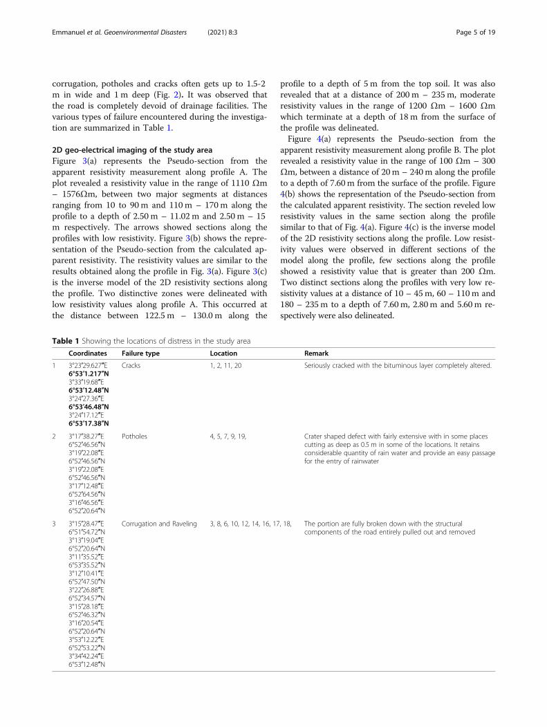
Table 1 Showing the locations of distress in the study area
Coordinates Failure type Location Remark
1 3°23′29.627″E6°53′1.217″N3°33′19.68″E6°53′12.48″N3°24′27.36″E6°53′46.48″N3°24′17.12″E6°53′17.38″N
Cracks 1, 2, 11, 20 Seriously cracked with the bituminous layer completely altered.
2 3°17′38.27″E6°52′46.56″N3°19′22.08″E6°52′46.56″N3°19′22.08″E6°52′46.56″N3°17′12.48″E6°52′64.56″N3°16′46.56″E6°52′20.64″N
Potholes 4, 5, 7, 9, 19, Crater shaped defect with fairly extensive with in some placescutting as deep as 0.5 m in some of the locations. It retainsconsiderable quantity of rain water and provide an easy passagefor the entry of rainwater
3 3°15′28.47″E6°51′54.72″N3°13′19.04″E6°52′20.64″N3°11′35.52″E6°53′35.52″N3°12′10.41″E6°52′47.50″N3°22′26.88″E6°52′34.57″N3°15′28.18″E6°52′46.32″N3°16′20.54″E6°52′20.64″N3°53′12.22″E6°52′53.22″N3°34′42.24″E6°53′12.48″N
Corrugation and Raveling 3, 8, 6, 10, 12, 14, 16, 17, 18, The portion are fully broken down with the structuralcomponents of the road entirely pulled out and removed
Emmanuel et al. Geoenvironmental Disasters (2021) 8:3 Page 5 of 19

Figure 5(a) represents the Pseudo-section from theapparent resistivity measurement along profile C. Lowresistivity value with the range of 50Ωm – 111Ωm, at adistance of 80 m − 120 m along the profile to a depth of15 m from the surface of the profile were observed.Figure 5(b) shows the representation of the Pseudo-section from the calculated apparent resistivity. The sec-tion revealed low resistivity values that is similar to whatwas obtained for the profile section in Fig. 5(a). Figure 5(c) shows the inverse model of the 2D resistivity sectionsalong the profile. Low resistivity values were observedalong the major sections. Very low resistivity values wereobserved at two distinctive zones from a distance of 40.0– 140 m, 190.0–210.0 m to a depth of 21 m and 25mrespectively.Figure 6(a) represents the Pseudo-section from the ap-
parent resistivity measurement along profile D. The plotrevealed a low resistivity value in the range of 100Ωm –350Ωm, at a distance of 10 m − 500m along the profileto a depth of 13 m from the surface of the profile. Figure6(b) shows the representation of the Pseudo-sectionfrom the calculated apparent resistivity. The section re-vealed a low resistivity values that is similar to what wasobtained for the profile section in Fig. 6(a). Figure 6(c)shows the inverse model of the 2D resistivity sections
along the profile. Low resistivity values were delineatedto depth of 15 m along the section. The implication ofthe low resistivity values as revealed from the sectionssignifies that the soils in the region are of poor founda-tion materials and not competent to withstand imposedload.The Cone Penetration Test (CPT) curves for the
studied soils are shown (Fig. 7) and the results ofthe CPT are shown in Table 2. The test was carriedout to determine the strength of near surface mate-rials and also access the in-situ strength of the soil.The results revealed a low cone resistance valuewhich indicates clayey sand material for samplingpoints 1, 2, 3 and 4. The linear natures of the curvesin sample point 3 and 4 as shown in (Fig. 7) re-vealed that the subsurface materials offer no resist-ance to the driven cone when compared to the curveplotted for sample point 1. The CPT depth valuesfor the locations are in the range of 2-16 m. Thedepth of penetration that offers no resistance asshown in (Fig. 7) shows that the area is unfit forerecting foundation. Erecting foundation on the sub-grade soil without applying the necessary treatmentwould result to the soil collapsing under an imposedload. The low value of the shear strength also
Fig. 3 Resistivity model for profile A
Emmanuel et al. Geoenvironmental Disasters (2021) 8:3 Page 6 of 19

revealed that the materials are undesirable as sub-grade materials for road pavement. The implicationof this is that the materials will expand and contractunder diverse weather conditions.The bearing capacity of the soil was derived using the
following equation:Undrained shear strength (Cu)
Cu ¼ qc=Nk ð1Þ
Where qc = cone end resistance valueNk = Point of refusal or termination pointAllowable Bearing Capacity
Ultimate bearing capacity is 5:14� Cu;where 5:14 is constant
ð2ÞAllowable bearing capacity ¼ 5:14� Cu=3 ð3Þ
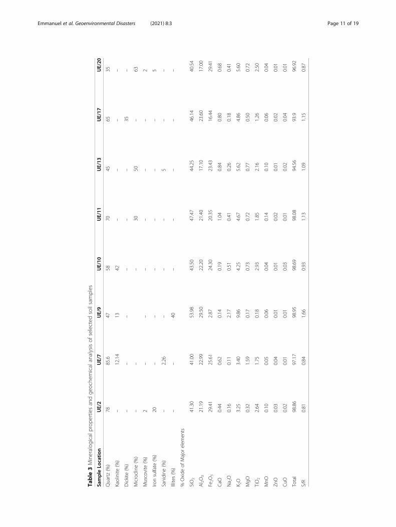
Geochemical and mineralogical properties of the selectedsoil samplesTable 3 shows the mineralogical properties of the se-lected eight samples. The prominent clay mineral typesobtained are quartz, illite, kaolinite and dickite. Therewas no presence of montmorillonite and smectite whichis accordance with was reported by (Okogbue 1988) that
Fig. 4 Resistivity model for profile B
Emmanuel et al. Geoenvironmental Disasters (2021) 8:3 Page 7 of 19

montmorillonite is not present in the south westernNigerian soils studied. The results of the mineralogy arealso in accordance with the results obtained in Table 4which revealed that the soils are of low to medium plas-ticity. This is also in affirmation to the presence of kao-linite which occurred as the major mineral in Table 3.Since kaolinites has the least affinity for water amongthe clay minerals, the studied soil will exhibit moderateexpansion in the presence of water. The results revealedthat the soils have low affinity for water and are welldrained. However, the occurrence of muscovite in somelocation may result to field compaction issue (Gidigasu1976; Ogunsanwo 1988; Onana et al. 2017).The result of geochemical analysis is presented on
Table 3. The main total chemical elements present inthe studied soils in decreasing order are SiO2, Al2O3,and Fe2O3 with averages of 44.77%, 21.9% and 21.60%respectively. The studied soil samples are characterized
by high amounts of silica from 40.54–53.98%, appre-ciable amount of sesquioxides (Al2O3 and Fe2O3) in therange of 17.10–29.5% for Al2O3, 2.87–29.41% for Fe2O3
and reasonable amount of bases (K2O and CaO). Theother chemical element concentrations were all lowerthan 5% (Table 6). The silica(S)/sesquioxides ratios(R)(Table 3) ranges from 0.81–1.67.BS 1377 (1990) andOnana et al. (2017) classified soils based on the silica/sesquioxides ratio as laterite if the is less than 1.33; later-itic if ratio ranges from 1.33 to 2 and non-lateritic if it isgreater than 2. According to this classification, 5% of thestudied soils are classified as non-lateritic soils while therest 95% are classified as lateritic. This result is in linewith the expected condition of leaching in a warm envir-onment like the study area (Loughnan 1969) where silicais leached away from decaying silicate rocks concentrat-ing secondary minerals like oxides of iron and aluminumas well as kaolinite in the soil.
Fig. 5 Resistivity model for profile C
Emmanuel et al. Geoenvironmental Disasters (2021) 8:3 Page 8 of 19

Geotechnical properties of the soilsThe results of the natural moisture content of the inves-tigated soil are shown in Table 4. The natural moisturecontent plays an important role in increasing or redu-cing density indices of soils and it varies based on thedepth of the soil, previous rainfall data and the existingdrainage conditions (Ramamurthy and Sitharam 2005).The moisture content is one of the components thataffect the dry density of soils (Garber and Hoel 1999).The periodic rainfall fluctuations in the moisture con-tents of soil will result to a large volume changes in theclayey soils. The natural moisture content of the ana-lyzed soil samples varied from 9.4 to 18.2% for subgrade,from 7.5% and 15.4% for base course between 6.8% and19.7% for sub-base course (Table 4). It was revealed thatsix sample locations values are higher than the specifiedvalue of (5–15%) recommended by the (FMWH 1997)
for road construction. This shows high water adsorptionpotential of the soil materials. The results revealed thatthe values obtained will lead to reduction in shearstrength (Ademilua 2018). Thus, they are unfit as sub-grade, subbase and base materials. High fluctuation inmoisture content often results to a large volume changesin the clayey soils (Daramola et al. 2018). The results ob-tained for the moisture content ranges from favorable,marginal favorable to unfavorable in accordance to(Underwood 1967).The results of the grain size distribution are summa-
rized in Table 4. The grain size analysis is important indetermining the strength of the soil and also determinethe particle size distribution of the studied soils (Nareshand Nowatzki 2006). The results show the percentageamount of clays, silts, fines, sand and gravel ranged from12.1–27.5%, 6.1–15.8%, 12–38.5%, 49.4–80.1% and 4.7–
Fig. 6 Resistivity model for profile D
Emmanuel et al. Geoenvironmental Disasters (2021) 8:3 Page 9 of 19

20.2% for subgrade, 18.5–39%, 7.4–37.2%, 30.2–62.8%,36–63.4% and 3.2–13.2 for subbase course and 26.2–48.9%,11.2–16.4,36.1–58.0%, 31.7–61.3% and 2.7–25.9%for base course. FMWH (1997) recommends subgradesoils to possess less than 35% amount of fines. The re-sults obtained in comparison with FMWH (1997) shows
that four soil samples did not meet up the specification.It can be inferred from the result that the soils are sus-ceptible to frequent shrinkage and swelling potentialsduring the variation in climatic seasons which are usu-ally the characteristics of the environmental condition ofthe study location. The high percentage of fines had
Fig. 7 CPT plots for the studied locations
Table 2 Results of CPT for the studied locations
Location CPT point 1 CPT point 2 CPT point 3 CPT point 4
Test Hole CPT 1 CPT 2 CPT3 CPT 4
Depth of Penetration (m) 2 6 16 12.5
Cone Resistance (kgf/cm2) 20 45 138 72
Undrained shear strength (Cu)KN/m2 10 7.50 8.63 5.76
Allowable bearing capacity KN/m2 17.13 12.85 14.77 9.86
Ultimate bearing capacity 50 37.5 43.125 28.5
Remarks Dark grey, stiff mediumgrained clayey sand
Dark grey, mediumgrained clayey sand
Dark grey, stiff, fine-mediumgrained Clayey sand
Dark grey, stiff, fine-mediumgrained Clayey sand
Emmanuel et al. Geoenvironmental Disasters (2021) 8:3 Page 10 of 19
Table
3Mineralog
icalprop
ertiesandge
oche
micalanalysisof
selected
soilsamples
Sample
Location
UE/2
UE/7
UE/9
UE/10
UE/11
UE/13
UE/17
UE/20
Quartz(%)
7885.6
4758
7045
6535
Kaolinite
(%)
–12.14
1342
––
––
Dickite
(%)
––
––
––
35–
Microcline(%)
––
–30
50–
63
Muscovite
(%)
2–
––
––
–2
Ironsulfate
(%)
20–
––
––
–5
Sanidine
(%)
–2.26
––
–5
––
Illites(%)
––
40–
––
––
%Oxide
ofMajor
elem
ents
SiO2
41.30
41.00
53.98
43.50
47.47
44.25
46.14
40.54
Al 2O3
21.19
22.99
29.50
22.20
21.40
17.10
23.60
17.00
Fe2O
329.41
25.61
2.87
24.30
20.35
23.43
16.44
29.41
CaO
0.44
0.62
0.14
0.19
1.04
0.84
0.80
0.68
Na 2O
0.16
0.11
2.17
0.51
0.41
0.26
0.18
0.41
K 2O
3.25
3.40
9.86
4.25
4.67
5.62
4.86
5.60
MgO
0.32
1.59
0.17
0.73
0.72
0.77
0.50
0.72
TiO2
2.64
1.75
0.18
2.93
1.85
2.16
1.26
2.50
MnO
0.10
0.05
0.06
0.04
0.14
0.10
0.06
0.04
ZnO
0.03
0.04
0.01
0.01
0.02
0.01
0.02
0.01
CuO
0.02
0.01
0.01
0.03
0.01
0.02
0.04
0.01
Total
98.86
97.17
98.95
98.69
98.08
94.56
93.9
96.92
S/R
0.81
0.84
1.66
0.93
1.13
1.09
1.15
0.87
Emmanuel et al. Geoenvironmental Disasters (2021) 8:3 Page 11 of 19

Table
4Results
ofthege
otechn
icaltest
SNSo
illaye
rsClays
%Silt%
Fine
s%
Sand
%Grave
l%SG
NMC
LLPL
PIFS
LSActivity
AASH
TOSo
ilgroup
UCS
OMC
%MDD
(g/cm
3)
CBR%
L1SBC
26.1
37.2
62.8
36.0
3.2
2.64
6.8
56.1
35.6
20.5
336
0.78
A-7
SSMH
241.52
5
L2SBC
18.5
12.78
30.2
63.4
7.7
2.52
12.6
30.4
22.4
8.0
228.16
0.43
A-24
CS
CL
151.65
4
L3SBC
399.6
47.2
49.4
4.3
2.53
20.6
49.7
26.2
23.5
21.2
110.60
A-7
CS
MI
211.67
8
L4SBC
31.3
7.4
39.5
48.3
13.2
2.53
1446.4
32.4
14.0
21.4
12.4
0.44
A-7
CS
MI
181.51
6
L5SBC
36.7
11.9
45.4
56.8
3.8
2.52
16.4
46.9
29.9
17.0
3211
0.46
A-7
CS
MI
211.61
6
L6SBC
2711.9
37.4
57.3
9.3
2.53
19.7
47.9
27.5
20.4
26.9
12.4
0.75
A-7
CS
CI
171.53
6
L7BC
26.5
16.4
41.9
49.3
10.8
2.54
14.9
52.2
29.2
23.0
43.9
10.2
0.86
A-7
CS
MI
121.65
5
L8BC
26.8
1539.8
61.3
2.7
2.56
7.5
25.1
19.9
5.20
2.0
60.19
A-4
CS
CL-MI
111.78
5
L9BC
26.2
11.7
36.1
3725.9
2.57
1541.7
29.7
1218.6
60.45
A-7
GS
MI
161.67
4
L10
BC48.9
12.1
58.0
31.7
9.3
2.62
15.4
42.4
30.5
11.9
228.29
0.24
A-6
SCMI
181.65
3
L11
SG24.2
11.2
34.4
56.2
8.4
2.56
15.8
34.3
21.7
34.3
319.57
0.29
A-26
CS
CL
31.70
3
L12
SG21.1
12.7
31.8
60.5
6.7
2.55
12.6
36.3
25.2
36.3
8.14
10.29
0.52
A-26
CS
CI
41.72
4
L13
SG26.9
6.1
3259.4
10.6
2.58
12.2
33.6
22.6
33.6
2611.29
0.40
A-26
CS
CL
121.71
12
L14
SG27
14.9
42.9
51.4
4.7
2.56
18.2
40.5
22.1
40.5
26.7
11.6
0.68
A-7
CS
CI
51.69
5
L15
SG13.4
15.8
27.2
649.8
2.57
11.5
26.8
18.2
26.8
118.86
0.64
A-24
CS
CL
41.74
4
L16
SG12.1
14.9
2870.1
4.9
2.55
13.2
36.6
18.7
36.6
5.35
3.86
1.47
A-2
SiC
CL
41.70
4
L17
SG22.6
8.7
28.3
50.5
20.2
2.54
2231.3
20.5
31.3
5.17
3.96
0.47
A-24
CS
CL
51.72
5
L18
SG8.5
7.5
1280.1
6.9
2.57
12.5
40.81
22.3
40.81
6.17
7.43
2.17
A-2
CS
CL
91.72
9
L19
SG21.8
14.8
35.6
55.7
11.7
2.50
11.6
45.4
23.8
45.4
3111.71
0.99
A-2-7
CS
CI
31.64
3
L20
SG27.5
1438.5
49.4
10.1
2.58
9.4
46.2
21.6
46.2
2612.71
0.89
A-7
CS
CI
41.64
4
Note:
MCMoisturecontent,SG
specificgravity,M
DDmaxim
umdrydensity,P
Iplasticity
index,LL
liquidlim
it,PL
plastic
limit,
CBRCa
liforniabearingratio
LSlinearshrin
kage,FSfree
swell,SS
sand
ysilt,
CSclayey
sand
,GS
gravellysand
,SCsand
yclay,S
iCsilty
clay,N
Pno
nplastic;SBC
sub-ba
sesoil;Ba
secourse
(BC)
materials;sub
-grade
soil(SGS)
Emmanuel et al. Geoenvironmental Disasters (2021) 8:3 Page 12 of 19

been linked to the predominance of clay which feasiblyexerts a dominant control on the mass behavior of soilwhich makes it mechanical unfit. The results from thestudy shows that that 60% did not meet the requirementfor subgrade soil while 40% meet the condition whencompared with (Underwood 1967) which states that sub-grade soils have less than 35% fines. The group index isthe parameter that gives an indication of the load bear-ing capacity within the AASHTO soil group. The result-ing increase in the group index will cause decrease inthe load carrying capacity. The results on the studiedsamples (Table 4, Fig. 8) revealed that the soils areclassified as A-26, A-24, A-2 and A-7 according toAASHTO (1993). The soils in these groups are con-sidered as clayey soils. The soils are grouped as fairto poor materials for road construction. The soilsclassified as A-2-7 soil on AASHTO soil classificationis regarded as poorly graded and poor graded (GP)on USCS soil classification with group index of 0(Gopal and Rao 2011). Therefore, they are unfit foruse as subgrade, subbase and base road constructionmaterials. The clayey soils are classified as fair topoor road materials, while the granular soils are clas-sified as excellent or good road materials.The consistency limits are used in determining the
settlement and strength characteristics of soils for roadconstruction (Sowers and Sowers 1970; Adeyemi 1995).The liquid, plastic limit and plasticity index results ofthe studied soils ranged from 25.1% - 52.2%, 19.9%–30.5% and 5.20–23.0% for base course, 30.4–56.1%,22.4%–35.6% and 8.0–23.5% for subbase course and26.8–46.2%, 18.2–25.2% and 7.1–24.6% for subgrade(Table 4). All the studied soils have the potentials of
causing a major deformation under load due to theirplastic natures. It is noteworthy that 95% of the studiedsoils are within (FMWH 1997) stipulated standard of50% for liquid limit making them suitable as use for sub-grade, sub-base and base materials for road construction.Moreover, only six of the studied samples fall within(FMWH 1997) stipulated for maximum plasticity indexof 20% for highway subgrade materials, whereas the restof the studied soil samples are above the stated recom-mended standard which makes it unsuitable for sub-grade construction materials. (Ola 1983) stated that soilswith plasticity index that is lower than 25% shows low tomedium swelling potential.The Casagrande’s plasticity chart (Fig. 9) is also used
soil classification (Cassagrande 1947). The studied soilsamples fall within the CI, CL and CH. These soils aregrouped on the basis of their liquid limit and plasticityindex. Two of the studied soil samples are within thelow plasticity (CL) whereas eighteen of the studied soilsamples falls within the medium to high plasticity (CI)categories on the Casagrande’s chart. The results re-vealed that 64% of the soils were plotted within the fieldof inorganic silts while 36% were plotted in the field ofinorganic clays. Additionally, when the plasticity indexlies between 20 and 35% then it satisfies the conditionfor high swelling potential and between 25 and 41% fora high degree of expansion (Gopal and Rao 2011). Theplasticity index is a predominant factor used in the se-lection of materials for subgrade and subbase. It givesmuch detailed facts on the properties and behavior ofclays in contrast to grain size data (Lambe 1951). Exces-sive plasticity often leads to fluctuations which arisesfrom plastic flow upon the application of axle load
Fig. 8 Stacked grain size distribution for samples UE1–20
Emmanuel et al. Geoenvironmental Disasters (2021) 8:3 Page 13 of 19

(Adeyemi 1995, 2002). Soils with extremely high liquidlimit are often prone to have low bearing capacity. Cas-sagrande (1947) stated that soil samples with low,medium and high plasticity will have low, medium andhigh compressibility respectively Table 5.The linear shrinkage of the soils varied from 6 to
12.4% for subbase course, 6–10.2% for base course and3.86–14.4% for subgrade (Table 4). Brink et al. (1982)and Ola (1983) reported that soils with linear shrinkagevalues exceeding 8% will be active, have a serious swell-ing potential and unsuitable as foundation materialsTable 6. Gidigasu (1973) reported that soils having linearshrinkage value greater than 10% will constitute a fieldcompaction problem. It was revealed that 70% of thestudied soil samples will constitute a field compactionproblem. It was revealed from the results that sevensamples from the subgrade samples have values greaterthan (Madedor 1983; Jegede 2004) as stipulated whichstates that 8% is the maximum value that is required forsubgrade soils as use for road construction. The implica-tion of the results is that during seasonal fluctuation inweather condition (the wet and dry seasons) the soilswill experience swelling and shrinkage. This is also evi-dent in the tropical climatic weather condition that isoften associated with the study location. From the re-sults of the linear shrinkage, it is noteworthy that only
three sample locations met the requirements for roadconstruction and the rest of the samples did not meetthe stated specification (FMWH 1997). The soils that arelinked to excessive shrinkage and swelling can bereworked to have the required needed characteristics forroad construction by stabilizing it (Olofinyo et al. 2019).The values of the specific gravity of the studied soil
range from 2.52–2.64 for subbase course, 2.54–2.62 forbase course and 2.54–2.58 for subgrade (Table 4). Thespecific gravity is known to link the strength of soil andare in turn used as criteria for selecting an appropriatematerial for highway pavement construction materialsespecially when used along with other pavement mate-rials. Low specific gravity is connected with clay mineral-ogy and weathering of feldspar that gave rise to the clay(Okogbue 1988; Owoyemi and Adeyemi 2012). The valueis low when compared with the residual soils within thebasement complex of Nigeria (Jegede 1998). It has beenrevealed by (Gidigasu 1983; Kabir and Taha 2004) thatspecific gravity has strong correlation between the chem-ical composition and the mineralogy of a soil. Gidigasu(1983) reported that the greater the specific gravity; thegreater the degree laterization. The more the percentageof clay fraction and alumina concentration the less thespecific gravity. The studied soils have been grouped as in-organic soils (Ramamurthy and Sitharam 2005).
Table 5 Expansive soil classification based on plasticity index and Liquid
Swell potential Plasticity index (%) Swell potential Liquid limit (%)
Holtz and Gibbs (1956) Chen (1988) IS:1498 (1970) Chen (1965) Snethan et al. (1977) IS: 1498 (1970)
Low < 18 0–15 < 12 Low < 30 < 50 35–50
Medium 15–28 10–35 12–23 Medium/marginal 30–40 50–60 50–70
High 25–41 20–55 23–32 High 40–60 > 60 70–90
Very high > 60 – 20–35
Fig. 9 Plasticity chart of the studied soil samples (Cassagrande 1947)
Emmanuel et al. Geoenvironmental Disasters (2021) 8:3 Page 14 of 19
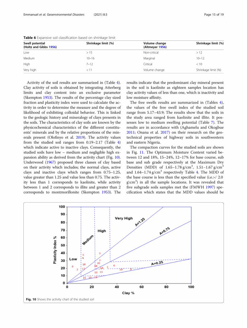
Activity of the soil results are summarized in (Table 4).Clay activity of soils is obtained by integrating Atterberglimits and clay content into an exclusive parameter(Skempton 1953). The results of the percentage clay sizedfraction and plasticity index were used to calculate the ac-tivity in order to determine the measure and the degree oflikelihood of exhibiting colloidal behavior. This is linkedto the geologic history and mineralogy of clays presents inthe soils. The characteristics of clay soils are known by thephysicochemical characteristics of the different constitu-ents’ minerals and by the relative proportions of the min-erals present (Olofinyo et al. 2019). The activity valuesfrom the studied soil ranges from 0.19–2.17 (Table 4)which indicate active to inactive clays. Consequently, thestudied soils have low – medium and negligible high ex-pansion ability as derived from the activity chart (Fig. 10).Underwood (1967) proposed three classes of clay basedon their activity which includes; the normal clays, activeclays and inactive clays which ranges from 0.75–1.25,value greater than 1.25 and value less than 0.75. The activ-ity less than 1 corresponds to kaolinite, while activitybetween 1 and 2 corresponds to illite and greater than 2corresponds to montmorillonite (Skempton 1953). The
results indicate that the predominant clay mineral presentin the soil is kaolinite as eighteen samples location hasclay activity values of less than one, which is inactivity andlow moisture affinity.The free swells results are summarized in (Tables 4),
the values of the free swell index of the studied soilrange from 5.17–43.9; The results show that the soils inthe study area ranged from kaolinite and illite. It pos-sesses low to medium swelling potential (Table 7). Theresults are in accordance with (Aghamelu and Okogbue2011; Onana et al. 2017) on their research on the geo-technical properties of highway soils in southwesternand eastern Nigeria.The compaction curves for the studied soils are shown
in Fig. 11. The Optimum Moisture Content varied be-tween 12 and 18%, 15–24%, 12–17% for base course, subbase and sub grade respectively at the Maximum DryDensities (MDD) of 1.65–1.78 g/cm3, 1.51–1.67 g/cm3
and 1.64–1.74 g/cm3 respectively Table 4. The MDD ofthe base course is less than the specified value (i.e.>/ 2.0g\cm3) in all the sample locations. It was revealed thatfive subgrade soils samples met the (FMWH 1997) spe-cification which states that the MDD values should be
Fig. 10 Shows the activity chart of the studied soil
Table 6 Expansive soil classification based on shrinkage limit
Swell potential(Holtz and Gibbs 1956)
Shrinkage limit (%) Volume change(Altmeyer 1956)
Shrinkage limit (%)
Low > 15 Non-critical > 12
Medium 10–16 Marginal 10–12
High 7–12 Critical < 10
Very high < 11 Volume change Shrinkage limit (%)
Emmanuel et al. Geoenvironmental Disasters (2021) 8:3 Page 15 of 19

above 1.70 g/cm3. FMWH (1997) recommends that soilsshould be in the range of 1.50–1.78 g/m3 for the MDDand optimum moisture content (OMC) of 8.56–12.02%.The implication is that the residual soils in the studiedarea have low bearing capacities due to its low OMCand MDD. The soils cannot be used as constructionmaterials except the materials are well compacted andstabilized appropriately in order for void spaces in thesoil to be removed; these will intermittently reducethe permeability and increase the strength of the soilmaterials. It is worthy to note that for any soils to besuitable as foundation materials such soil must becompacted above the MDD and the OMC values inorder for its to give rise to the required strength thatwill withstand the impact of load and impede theinflow of water (Olofinyo et al. 2019). The results incomparison to Underwood (1967) revealed that thestudied soil samples have fair to poor foundationattribute. This comparative low maximum dry densityvalue is potentially responsible factor to the persist-ence incidence of road failure in the study area.The CBR curves for the studied soils are shown in
Fig. 12. The California bearing ratio is usually used in
evaluating the soils strength of subgrade, subbase andbase course as road construction materials (Adeyemi2002; Adeyemi 2013; Olofinyo et al. 2019). The CBRvalues for the sample locations is in the range of 3–5%for base course, 4–8% for subbase course and 3–12% forsubgrade (Table 4). These results fell below the max-imum of 80% recommended by the (FMWH 1997). Therecommended CBR value of >/5% for subgrade was metin some location. The implication of these results is thatthe soils are of low strength and for the strength of thesoil to be increased, soil improvement methods wouldhave to be employed before it can be used as road con-struction. (FMWH 1997) proposed that California Bear-ing Ratio (CBR) should be greater than 10% for subgradematerials. The results revealed that the CBR values ofsome soils are lower than the recommended value. Thecorresponding low values of CBR are partly responsiblefor the failure of highway pavement in the study area.
ConclusionGeotechnical, mineralogical, geochemical and geophysicalinvestigations have been carried out along Sagamu-Papalanto highway southwestern Nigeria. The resultsrevealed that the soil samples are majorly granular andclayey soils, easily compacted with poor drainage. The soilsamples indicate a variable moisture content due to the cli-matic and hydrological conditions of the area. The result ofthe studied soil based on AASHTO classification revealedthat 20% of the soils are classified as A-2-4 whereas othersoutstanding 80% are classify as A-2-6, A-5 and A-7 whichare reflective of fair to poor foundation attribute. However,the low specific gravity values obtained from the
Fig. 11 Stacked compaction curves for samples UE 1–20
Table 7 Expansive soil classification based on shrinkage index(IS 1498 (1970))
Degree of expansivity/swell potential Shrinkage index (%)
Low < 15
Medium 15–30
High 30–60
Very high > 60
Emmanuel et al. Geoenvironmental Disasters (2021) 8:3 Page 16 of 19

investigation is partly responsible for the failure of road asan increase in specific gravity values reflects a reduction invoid ratio. The mineralogical investigation showed the ab-sence of swelling clay such as montmorillonite and smect-ite. The minerals identified are kaolinites and illites in amajor proportions and muscovite in a minor proportion.The chemical test also revealed that the soils are true later-ites showing high concentration of sesquioxides S/R (ironand aluminum oxides). The low CBR values obtainedmakes the soil materials to be unfit for use as road con-struction materials. Hence, their use as subgrade, subbaseconstruction materials for heavy road traffic will requirepre-treatment with non- plastic soils like bitumen, cementand lime. Low resistivity values below 200Ωm were ob-tained in some sections of profile 2,3 and 4. This revealedthe presence of an incompetent material beneath the sub-surface of the road. These materials are unfit as subgradematerials for road pavement, as it will regularly expand andcontract under varying weather condition. The frequent ex-pansion and contraction of these subgrade material oftenresults to cracks and the eventual collapse of the road. Inaddition, moderately high resistivity values greater 200 Ωmwere observed along the profile 1 shows the presence exist-ence of laterite material which is an acceptable subgradematerial for road pavement. The results of the geotechnicaland geophysical investigation showed that the materials areof low shear strength but the strength can be improvedwhen subjected to stabilization measures. This should beput into consideration during the reconstruction and re-habilitation of the exiting road. Other contributing factorssuch as inadequate drainage system, paucity of mainten-ance, poor pavement coating of the road, and substandard
construction materials are factors leading to a total failureof the road. Sections of the road with sandy and clayeymaterials should be scooped out from the subsurface to adepth of 3m – 5m from the top soil of the road and putback with competent fill materials.
AcknowledgementsMany thanks to the editor and reviewers for their assistance in re-shapingand improving the quality of this research article.
Authors’ contributionsUOE carried out the field and Laboratory work drafted the manuscript. IOand UBU Conceived the study participated in its design, coordination andgave academic guidance. All authors read and approved the finalmanuscript.
FundingFunding of the entire work was personal.
Availability of data and materialsThe data sets used and analyzed during the current study are available fromthe corresponding author on request.
Competing interestsThe authors declare that they have no competing interests.
Received: 11 July 2020 Accepted: 23 December 2020
ReferencesAASHTO (1993) Standard specification for transportation materials and methods
of sampling and testing, 14th edn. American Association of State Highwayand Transportation Officials, Washington, DC
Abam TKS, Osadebe CC, Omange GN (2005) Influence of geology onpavement performance: A case study of Shagamu–Benin road. Glob JGeol Sci 3(1):17–24
Adegoke OS, Ogbe FGA, Jan Du Chene RE (1976) Excursion to the Ewekoroquarry (Paleocene-Eocene). Geol. Guide Nigerian Cretaceous-Recent Loc,pp 1–17
Ademilua O (2018) Geotechnical characterization of subgrade soils inSouthwestern Part of Nigeria. In: Proceedings of first and second
Fig. 12 Stacked CBR curves for samples UE 1–20
Emmanuel et al. Geoenvironmental Disasters (2021) 8:3 Page 17 of 19

international conferences of the Nigerian Association of Engineering Geologyand the Environment, Lagos, Nigeria, n.d.. vol 1, pp. 42–48.
Adeyemi GO (1995) The influence of parent rock factor on some engineeringindex properties of three residual lateritic soils in southwestern Nigeria. BullInt Assoc Eng Geol 52:3–8
Adeyemi GO (2002) Geotechnical properties of lateritic soils developed overquartz schist in Ishara area southwestern Nigeria. J Mining Geol 38(1):65–69
Adeyemi GO (2013) Engineering geology: the Big Heart for structures and theirenvironment. In: An Inaugural Lecture 2012/2013 University of Ibadan 21February 2013. Ibadan University Press, Publishing House University ofIbadan, Ibadan, p 91
Aghamelu OP, Okogbue CO (2011) Geotechnical assessment of road failures inthe Abakaliki area, southwestern Nigeria. Int J Civil Environ Eng 11(2):12–24 s
Ako BD, Adegoke OS, Peters SW (1980) Stratigraphy of Oshosun formation inSouthwestern Nigeria. J Min Geo. 17:99–106
Akpan O (2005) Relationship between road pavement failures, engineeringindices and underlying geology in a tropical environment. Glo J Geos 3(2):99–108
Alexander WS, Maxwell J (1996) Controlling shrinkage cracking from expansiveclay sub-grade. In: Francken LB, Molenaar AA (eds) Reflective cracking inpavements, 2nd edn. E&FN Spon, London, pp 64–71
Altmeyer WT (1956) Discussion. Transit ASCE 121:666–669Amadi AN, Akande WG, Okunlola IA, Jimoh MO, Francis-Deborah G (2015)
Assessment of the geotechnical properties of lateritic soils in Minna, NorthCentral Nigeria for road design and construction. Amer j Min & Metal 3(1):15–20 https://doi.org/10.1269/ajmm-3-1-3
Amadi AN, Eze CJ, Igwe CO, Okunlola IA, Okoye NO (2012) Architect’s andGeologist’s view on the causes of building failures in Nigeria. Mod Appl Sci6(6):31–38
Arora KR (2009) Soil mechanics and foundation engineering. Standard PublishersDistributors, Delhi
ASTM D4318–10(2015) Standard Test Methods for Laboratory Consistency LimitsTest.
ASTM D6913–04 (2009) Standard Test Methods for Particle Size Distribution(Gradation). ASTM International, West Conshohocken
ASTM D698–12. (2015) Standard Test Methods for Laboratory Compaction Testfor Road Bases.
ASTM D854-10 (2015) Standard Test Methods for Laboratory Porosity andPermeability Test for Road Bases.
ASTM D854–14 (2015) Standard Test Methods for Specific Gravity of Soil. WestConshohocken, www.astm.org
Balogun O (2003) Senior secondary atlas. Longman, LagosBrink ABA, Parridge JC, Williams AAB (1982) Soil survey for engineering.
Clarederon, OxfordBritish Standard (BS) 1377 (1990) Methods of testing soils for civil engineering
purposes. British Standards Institution, LondonBritish Standard Institute (BSI) 5930 (1999) Code of practice for site investigation.
London. p 148Carrol D (1971) Clay minerals: a guide to their X-ray identification of soils. In:
Geological society of America special paper 126, USACassagrande A (1947) Classification and identification of soils. Am Soc Civil Eng.
113:783–811Chen FH (1965) The use of piers to prevent the uplifting of lightly loaded
structure founded on expansive soil. In: Concluding proceedings engineeringeffects of moisture change in soils, international research and engineeringconference on expansive clay soils. A&M, Texas, pp 152–171
Chen FH (1988) Foundations on expansive soils. Elsevier, AmsterdamDaramola SO, Malomo S, Asiwaju-Bello YA (2015) Engineering geology of
failed sections of Isua–Idoani road Southwestern Nigeria. J Enviro Ear Sci5(19):38–45
Daramola SO, Malomo S, Asiwaju-Bello YA (2018) Premature failure of a majorhighway in Southwestern Nigeria. The case of Ipele–Isua highway. Inter JGeo-Eng 9:1–12
FMWH (1997) Nigerian general specifications for roads and bridges. FederalHighway Department. 2:145–284
Garber JN, Hoel LA (1999) Traffic and highway engineering. Brooks/Colepublishing.
Gidigasu MD (1973) Review of identification of problem laterite soils in highwayengineering. Transport Res Board 497:96–11
Gidigasu MD (1976) Geotechnical evaluation of residual gravels in pavementconstruction. Eng Geo 15:173–794
Gidigasu MD (1983) Development of acceptance specifications for tropical gravelpaving materials. Eng Geo 19:213–240
Gopal R, Rao ASR (2011) Basic and Applied Soil Mechanics, 2nd edn. New AgeInt’l, New Delhi
Graham J, Shields DH (1984) Influence of geology and geological processes onthe geotechnical properties of plastic clay. J Eng Geo 22(2):109–126
Gupta BL, Gupta A (2003) Roads, railways, bridges, tunnel and harbor dockengineering, 5th edn. Standard Publishers Distributors, Nai Sarak, New Delhi
Holtz WG, Gibbs HJ (1956) Engineering properties of expansive clays. Trans ASCE121:641–663
Ighodalo CA (2009) Transport Infrastructure and Economic Growth in Nigeria.Revised Paper Submitted for Presentation at the First International Conferenceon Transport Infrastructure (ICTI 2008), Beijing, China. April 24-26, 2008
International Joint Committee Properties on Mineral Powder Diffraction Standard(1980) Mineral powder diffraction file data book. IJCPS, Pennsylvania
IS: 1498 (reaffirmed 1987) (1970) Indian standard classification and identificationof soils for general engineering purposes. BIS, New Delhi
Jegede G (1997) Highway pavement failure induced by soil properties along theF209 highway at Omuoke, southwestern Nigeria. Nig J Sci.
Jegede G (1998) Effects of some engineering and geological factors on highwayfailures in parts of Southwestern Nigeria. Unpublished Ph.D. thesis. FederalUniversity of Technology, Akure, p 251
Jegede OG (2004) Highway pavement failure induced by poor geotechnicalproperties at a section along the F209 Okitipupa-Igbokoda highway,Southwest Nigeria. Ife J Sci 6(1):41–44
Jegede OG, Olaleye BM (2013) Evaluation of engineering geologic andgeotechnical properties of subgrade soils along re-alligned Igbara-IkogosiHighway, South-west Nigeria. Inter J Eng &Sci 2(5):18–21
Kabir MH, Taha MR (2004) Assessment of physical properties of a granite residualsoil as an isolation barrier. Elec J Geot Eng 92:13
Lambe TW (1951) Soil testing for engineers. Wiley, New York, p 165Loughnan FC (1969) Chemical weathering of silicate minerals. Elsevier, New YorkMadedor AO (1983) Pavement design guidelines and practice for different
geological areas in Nigeria. In: Ola SA (ed) Tropical soils of Nigeria inengineering practices. Balkena. Publishers, Rotterdam, pp 291–298
Meshida EA (2006) Highway failure over talc–tremolite schist terrain: a case studyof the Ife to Ilesha Highway, Southwestern Nigeria. Bull Eng Geo & Environ65:457–461. https://doi.org/10.1007/s10064-005-0037-7
Naresh CS, Nowatzki PE (2006) Soils and foundations. Ref Man Fed Highway Adm2:8–75
Nwankwoala HO, Amadi AN (2013) Geotechnical investigation of sub-soil androck characteristics in parts of Shiroro–Muya–Chanchaga Area of Niger State,Nigeria. Inter J Ear Sci& Eng 6(1):8–17
Nwankwoala HO, Amadi AN, Ushie FA, Warmate T (2014) Determination ofsubsurface geotechnical properties for foundation design and constructionin Akenfa Community, Bayelsa, Nigeria. Amer J Civ Eng Arch 2(4):130–135
Ogunsanwo O (1988) Basic geotechnical properties, chemistry andmineralogy of some laterite soils from southwestern Nigeria. Bul InterAss Eng Geo 37:131–135
Oke SA, Amadi AN, Abalaka AE, Nwosu JE, Jibade SA (2009) Index andcompaction properties of laterite deposits for road construction in MinnaArea, Nigeria. Nig J Cons Tech Man 10(1–2):28–35
Okogbue CO (1988) The physical and mechanical properties of laterite gravelsfrom south eastern Nigeria relative to their engineering performance. J AfrEarth Sci 5(6):659–664
Okosun EA (1990) Review of the Cretaceous Stratigraphy of the DahomeyEmbayment, West Africa. Creta Res 11:17–27
Ola SA (1983) In: Ola SA, Balkama AA (eds) Tropical soils of Nigeria in engineeringpractice, Netherlands, pp 61–24
Olofinyo OO, Olabode OF, Fatoyinbo IO (2019) Engineering properties of residualsoils in part of Southwestern Nigeria: implication for road foundation. SNAppl Sci. 1:507. https://doi.org/10.1007/s42452-019-0515-3
Omatsola ME, Adegoke OS (1981) Tectonic Evolution of Cretaceous Stratigraphyof the Dahomey Basin. J Min & Geo. 18(1):130–137
Onana VL, Ngooze A, MedjoEko R, Ntouala RFD, NangaBineli MT, Owoudou BN,Ekodeck GE (2017) Geological identification, geotechnical and mechanicalcharacterization of charnokite-derived lateritic gravels from southernCameroon for road construction purposes. Trans Geotech 10:35–46
Owoyemi OO, Adeyemi GO (2012) Highway geotechnical properties of somelateritic soils from the sedimentary terrain of Lagos–Ibadan highway. Int J SciEng Res 3(1):1–14
Emmanuel et al. Geoenvironmental Disasters (2021) 8:3 Page 18 of 19

Ramamurthy TN, Sitharam TG (2005) Geotechnical engineering. S. Chand, NewDelhi, p 28
Salami BM, Falebita DE, Fatoba OJ, Ajala MO (2012) Integrated geophysical andgeotechnical investigation of a bridge site—a case study of swamp/creekenvironment in SE Lagos, Nigeria. Ife J Sci 14(1):75–82
Skempton AW (1953) The colloidal activity of clays, Proceeding of the 3rdinternational conference on soil mechanics, Zurich, pp 57–5s
Snethan DR, Johnson LD, Patrick DM (1977) An evaluation ofexpedient ofmethodology for identification of potentiallyexpansive soils. In: Soils andPavements Lab, US Army Eng.Water Way Exp. Station, Vicksburg, MS, ReportNo. FHWA-RE-77-94, NTIS PB-289-164.
Sowers GM, Sowers GE (1970) Introductory soil mechanics and foundations.Macmillan, New York, p 556
Underwood LB (1967) Classification and identification of Shales. J Soil MechFound 93(11):97–116
Publisher’s NoteSpringer Nature remains neutral with regard to jurisdictional claims inpublished maps and institutional affiliations.
Emmanuel et al. Geoenvironmental Disasters (2021) 8:3 Page 19 of 19