an overview of geochemical characteristics of olkaria ...theargeo.org/fullpapers/fullpaper/full...
TRANSCRIPT
Proceedings 5th African Rift geothermal Conference
Arusha, Tanzania, 29-31 October 2014
1
An Overview of Geochemical Characteristics of Olkaria Geothermal Field, Kenya Becky, W.
Geothermal Energy Training and Research Institute - Dedan Kimathi University of Technology
P. O Box 69475-00400 Nairobi
Keywords: Geothermal, Geochemistry, Olkaria
ABSTRACT
Geochemistry is extensively applied in all phases of geothermal exploration and development. Geochemical surveys are conducted
mainly to acquire information such as sub-surface temperatures, identify source(s) of the geothermal fluids, and assess chemical
characteristics of these fluids and their suitability for electric power production or other non-electrical uses. Geochemistry, as an
exploration and exploitation monitoring tool, has been used successfully in Olkaria geothermal field, Kenya. Results from the data
analysis indicate availability of geothermal fluids at temperatures of over 2500C. The reservoir is defined by high CO2 and Rn-222
measured in the soil gas, and high gas content in the fumarole discharges and the high volatile constituents in the fumarole steam
condensates. In this paper we review the geochemical signatures of the Olkaria geothermal field, including the methodologies
applied and their implications for geothermal energy.
1. INTRODUCTION
Olkaria geothermal area is found in the section of the east African rift valley that passes through Kenya, 120km from the capital,
Nairobi. It is located in a volcanic complex cut across by N-S, NW-SE and SW-NE normal faults. It has surface manifestations of
altered ground and fumarole activity with few hot springs Exploration of the Olkaria geothermal resource started in 1956 with
deep drilling commencing in 1973. To date slightly over 250MWe have been installed with an additional 280MWe projected to
be online by the end of 2014. The field has three independent players, KenGen, Orpower 4 inc and Oserian development company.
The field is divided into sectors which are developed and underdevelopment and include Olkaria East field (Olkaria I), Olkaria
North East field (Olkaria II), Olkaria west field (Olkaria III) Olkaria Domes (Olkaria IV), Olkaria Central and Olkaria
South.
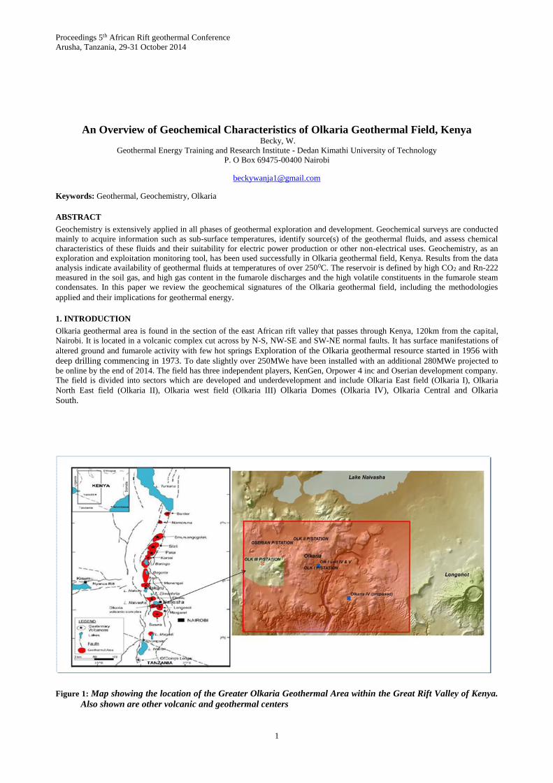
Figure 1: Map showing the location of the Greater Olkaria Geothermal Area within the Great Rift Valley of Kenya.
Also shown are other volcanic and geothermal centers
Mutua
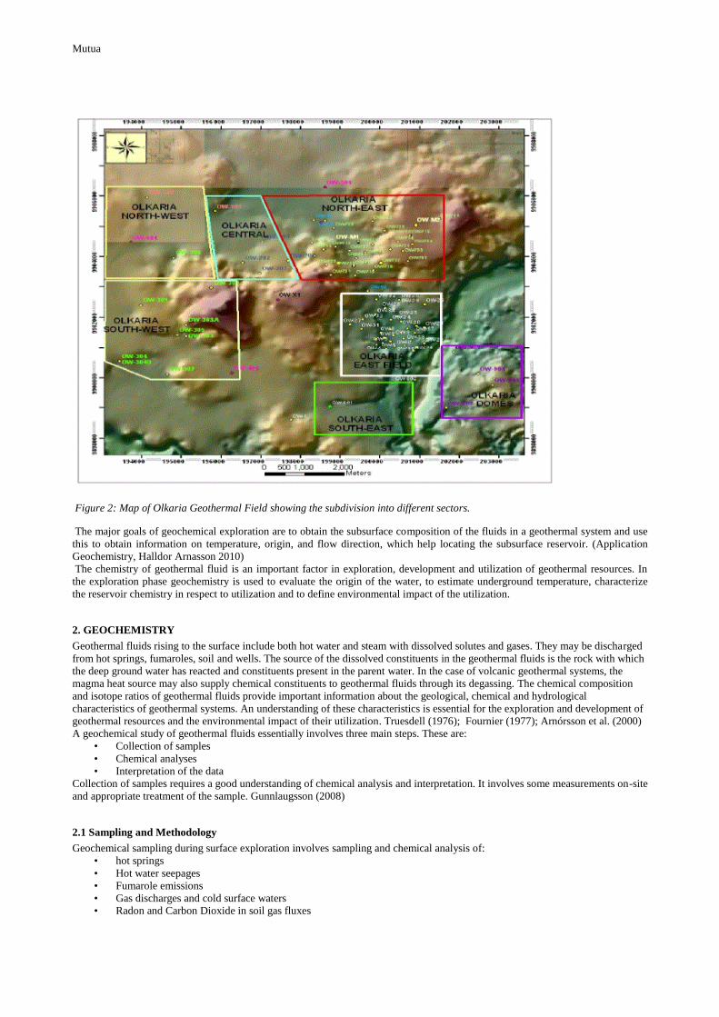
Figure 2: Map of Olkaria Geothermal Field showing the subdivision into different sectors.
The major goals of geochemical exploration are to obtain the subsurface composition of the fluids in a geothermal system and use
this to obtain information on temperature, origin, and flow direction, which help locating the subsurface reservoir. (Application
Geochemistry, Halldor Arnasson 2010)
The chemistry of geothermal fluid is an important factor in exploration, development and utilization of geothermal resources. In
the exploration phase geochemistry is used to evaluate the origin of the water, to estimate underground temperature, characterize
the reservoir chemistry in respect to utilization and to define environmental impact of the utilization.
2. GEOCHEMISTRY
Geothermal fluids rising to the surface include both hot water and steam with dissolved solutes and gases. They may be discharged
from hot springs, fumaroles, soil and wells. The source of the dissolved constituents in the geothermal fluids is the rock with which
the deep ground water has reacted and constituents present in the parent water. In the case of volcanic geothermal systems, the
magma heat source may also supply chemical constituents to geothermal fluids through its degassing. The chemical composition
and isotope ratios of geothermal fluids provide important information about the geological, chemical and hydrological
characteristics of geothermal systems. An understanding of these characteristics is essential for the exploration and development of
geothermal resources and the environmental impact of their utilization. Truesdell (1976); Fournier (1977); Arnórsson et al. (2000)
A geochemical study of geothermal fluids essentially involves three main steps. These are:
• Collection of samples
• Chemical analyses
• Interpretation of the data
Collection of samples requires a good understanding of chemical analysis and interpretation. It involves some measurements on-site
and appropriate treatment of the sample. Gunnlaugsson (2008)
2.1 Sampling and Methodology
Geochemical sampling during surface exploration involves sampling and chemical analysis of:
• hot springs
• Hot water seepages
• Fumarole emissions
• Gas discharges and cold surface waters
• Radon and Carbon Dioxide in soil gas fluxes
Mutua
These geothermal fluids are characterized for their suitability in electricity production and other non-electrical uses. Samples
collected are analyzed for chemical parameters associated with major geothermal activity. The data obtained is used to infer
reservoir temperatures and chemical characteristics hence assess the suitability of the area for further exploration by deep drilling.
The area under production is also monitored through geochemical sampling programs. Gas samples and water samples are collected
for analysis. Newly drilled wells in the various sectors of development or further development have been discharge tested and fluid
chemistry of the areas analyzed. The sample collection and analysis methods in the Olkaria field are based on those of arnasson et
al (2006 and 2007).
Steam samples are collected with a stainless steel webre separator connected between the wellhead and an atmospheric silencer on
the discharging wells. Another water sample is also obtained from the weirbox.
2.1.1 Water/condensate sampling and analysis
Sampling of water from the springs, hot water seepages and fumaroles has been carried out and the samples collected divided into
five portions after filtration. The first portion is used for immediate analysis for hydrogen sulphide (H2S), carbon dioxide (CO2),
pH, conductivity, and total dissolved solids (TDS) while others are preserved for later analysis in the laboratory. A measured
amount of 5% zinc acetate solution is added to one portion of the sample for the fixation of sulphates. 1 ml of concentrated nitric
acid is added to another portion for the preservation of metal ions. A portion of the sample for silica analysis is diluted ten times to
avoid polymerization of monomeric silica.
2.1.2 Gas sampling and analysis
The gases are sampled by directing the steam into an evacuated gas (giggenbach) flask containing 50 ml of 40% NaOH solution
with cold water continuously pouring on top of the flask to cool it (Figure 3.2). The acidic gases (CO2 and H2S) are absorbed into
the NaOH solution giving room in the evacuated flask for the minor none condensable gases (NCG’s) usually found in thermal
fluids to concentrate to measureable levels. The gas samples are analyzed for hydrogen (H2), methane (CH4), nitrogen (N2) and
oxygen (O2) by use of a gas chromatography while the condensate samples are used for the analysis of volatiles that on boiling
partition into the steam phase. CO2 and H2S are analyzed titrimetrically using 0.01M hydrochloric acid and 0.01M mercuric acetate
respectively.
CO2 and H2S are determined titrimetrically in a solution of a strong alkali (NaOH or KOH), by an alkalinity titration with HCl, and
by either iodometry or with mercuric acetate using dithizone as an indicator. Gases that are not absorbed by the strong alkali (N2,
H2, CH4 and O2,) are determined by gas chromatography.
2.1.3 Soil gas sampling to determine carbon dioxide and radon radioactivity.
Previous geochemical studies on diffuse soil degassing have been carried out in a number of geothermal areas. CO2 soil gas
investigations have been conducted in volcanic areas to examine unexpected rise in CO2 flux (e.g. Farrar et al. 1995; McGee and
Gerlach 1998), estimate total volcanic flux from volcanic vents and diffuse flank emissions (e.g. Allard et al. 1991; Chiodini et al.
1996), and to classify tectonic structures related to volcanic degassing (e.g. Giammanco et al. 1997; Bergfeld 1998). The deep-
seated faults in the crust tap magmatic CO2, which is transmitted to the surface where it is naturally lost through the soil. Carbon
dioxide (CO2) of magmatic origin is normally channelled through deep-seated tectonic structures close to the surface of the earth
and then seeps out of the ground through the soil.
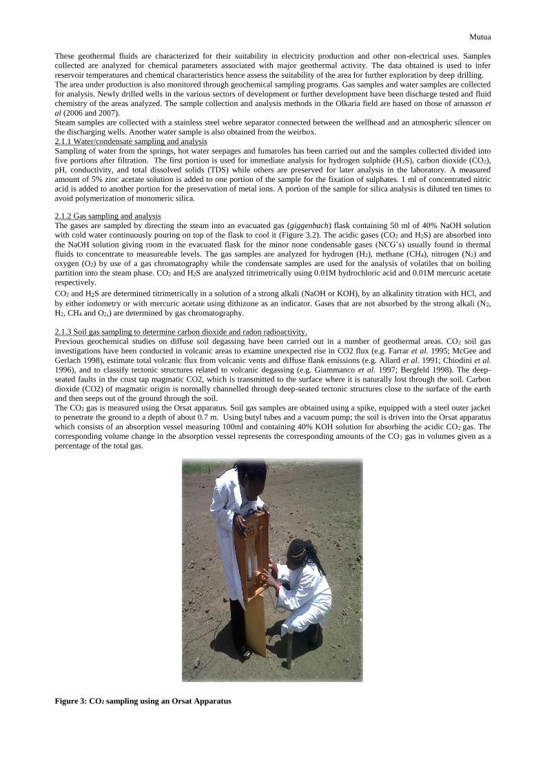
The CO2 gas is measured using the Orsat apparatus. Soil gas samples are obtained using a spike, equipped with a steel outer jacket
to penetrate the ground to a depth of about 0.7 m. Using butyl tubes and a vacuum pump; the soil is driven into the Orsat apparatus
which consists of an absorption vessel measuring 100ml and containing 40% KOH solution for absorbing the acidic CO2 gas. The
corresponding volume change in the absorption vessel represents the corresponding amounts of the CO2 gas in volumes given as a
percentage of the total gas.
Figure 3: CO2 sampling using an Orsat Apparatus
Mutua
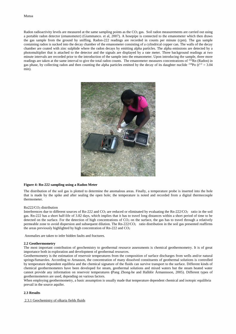
Radon radioactivity levels are measured at the same sampling points as the CO2 gas. Soil radon measurements are carried out using
a portable radon detector (emanometer) (Giammanco. et al, 2007). A hosepipe is connected to the emanometer which then draws
the gas sample from the ground by sniffing. Radon-222 readings are recorded in counts per minute (cpm). The gas sample
containing radon is sucked into the decay chamber of the emanometer consisting of a cylindrical copper can. The walls of the decay
chamber are coated with zinc sulphide where the radon decays by emitting alpha particles. The alpha emissions are detected by a
photomultiplier that is attached to the detector and the signals are displayed by a rate meter. Three background readings at two
minute intervals are recorded prior to the introduction of the sample into the emanometer. Upon introducing the sample, three more
readings are taken at the same interval to give the total radon counts. The emanometer measures concentrations of 222Rn (Radon) in
gas phase, by collecting radon and then counting the alpha particles emitted by the decay of its daughter nuclide 218Po (t1/2 = 3.04
min).
Figure 4: Rn-222 sampling using a Radon Meter
The distribution of the soil gas is plotted to determine the anomalous areas. Finally, a temperature probe is inserted into the hole
that is made by the spike and after sealing the open hole; the temperature is noted and recorded from a digital thermocouple
thermometer.
Rn222/CO2 distribution
Interferences due to different sources of Rn-222 and CO2 are reduced or eliminated by evaluating the Rn-222/CO2 ratio in the soil
gas. Rn-222 has a short half-life of 3.82 days, which implies that it has to travel long distances within a short period of time to be
detected on the surface. For the detection of high concentrations of CO2 on the surface, the gas has to travel through a relatively
permeable zone to avoid dispersion and subsequent dilution. The Rn-222/CO2 ratio distribution in the soil gas presented reaffirms
the areas previously highlighted by high concentration of Rn-222 and CO2
Anomalies are taken to infer hidden faults and fractures.
2.2 Geothermometry
The most important contribution of geochemistry to geothermal resource assessments is chemical geothermometry. It is of great
importance both in exploration and development of geothermal resources.
Geothermometry is the estimation of reservoir temperatures from the composition of surface discharges from wells and/or natural
springs/fumaroles. According to Arnasson, the concentration of many dissolved constituents of geothermal solutions is controlled
by temperature dependent equlibria and the chemical signature of the fluids can survive transport to the surface. Different kinds of
chemical geothermometers have been developed for steam, geothermal solutions and mixed waters but the steam heated water
cannot provide any information on reservoir temperatures (Pang Zhong-he and Halldór Ármannsson, 2005). Different types of
geothermometers are used, depending on various factors.
When employing geothermometry, a basic assumption is usually made that temperature dependent chemical and isotopic equilibria
prevail in the source aquifer.
2.3 Results
2.3.1 Geochemistry of olkaria fields fluids
Mutua
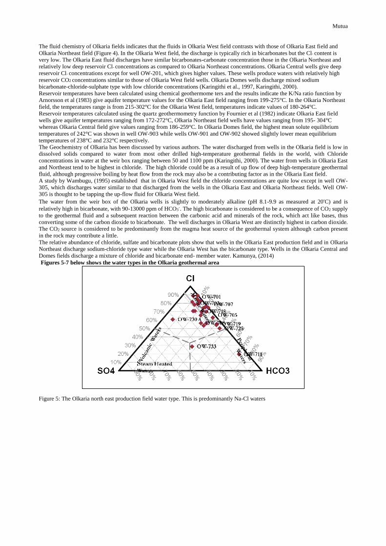
The fluid chemistry of Olkaria fields indicates that the fluids in Olkaria West field contrasts with those of Olkaria East field and
Olkaria Northeast field (Figure 4). In the Olkaria West field, the discharge is typically rich in bicarbonates but the Cl- content is
very low. The Olkaria East fluid discharges have similar bicarbonates-carbonate concentration those in the Olkaria Northeast and
relatively low deep reservoir Cl- concentrations as compared to Olkaria Northeast concentrations. Olkaria Central wells give deep
reservoir Cl- concentrations except for well OW-201, which gives higher values. These wells produce waters with relatively high
reservoir CO2 concentrations similar to those of Olkaria West field wells. Olkaria Domes wells discharge mixed sodium
bicarbonate-chloride-sulphate type with low chloride concentrations (Karingithi et al., 1997, Karingithi, 2000).
Reservoir temperatures have been calculated using chemical geothermome ters and the results indicate the K/Na ratio function by
Arnorsson et al (1983) give aquifer temperature values for the Olkaria East field ranging from 199-275°C. In the Olkaria Northeast
field, the temperatures range is from 215-302°C for the Olkaria West field, temperatures indicate values of 180-264°C.
Reservoir temperatures calculated using the quartz geothermometry function by Fournier et al (1982) indicate Olkaria East field
wells give aquifer temperatures ranging from 172-272°C, Olkaria Northeast field wells have values ranging from 195- 304°C
whereas Olkaria Central field give values ranging from 186-259°C. In Olkaria Domes field, the highest mean solute equilibrium
temperatures of 242°C was shown in well OW-903 while wells OW-901 and OW-902 showed slightly lower mean equilibrium
temperatures of 238°C and 232°C respectively.
The Geochemistry of Olkaria has been discussed by various authors. The water discharged from wells in the Olkaria field is low in
dissolved solids compared to water from most other drilled high-temperature geothermal fields in the world, with Chloride
concentrations in water at the weir box ranging between 50 and 1100 ppm (Karingithi, 2000). The water from wells in Olkaria East
and Northeast tend to be highest in chloride. The high chloride could be as a result of up flow of deep high-temperature geothermal
fluid, although progressive boiling by heat flow from the rock may also be a contributing factor as in the Olkaria East field.
A study by Wambugu, (1995) established that in Olkaria West field the chloride concentrations are quite low except in well OW-
305, which discharges water similar to that discharged from the wells in the Olkaria East and Olkaria Northeast fields. Well OW-
305 is thought to be tapping the up-flow fluid for Olkaria West field.
The water from the weir box of the Olkaria wells is slightly to moderately alkaline (pH 8.1-9.9 as measured at 20⁰C) and is
relatively high in bicarbonate, with 90-13000 ppm of HCO3-. The high bicarbonate is considered to be a consequence of CO2 supply
to the geothermal fluid and a subsequent reaction between the carbonic acid and minerals of the rock, which act like bases, thus
converting some of the carbon dioxide to bicarbonate. The well discharges in Olkaria West are distinctly highest in carbon dioxide.
The CO2 source is considered to be predominantly from the magma heat source of the geothermal system although carbon present
in the rock may contribute a little.
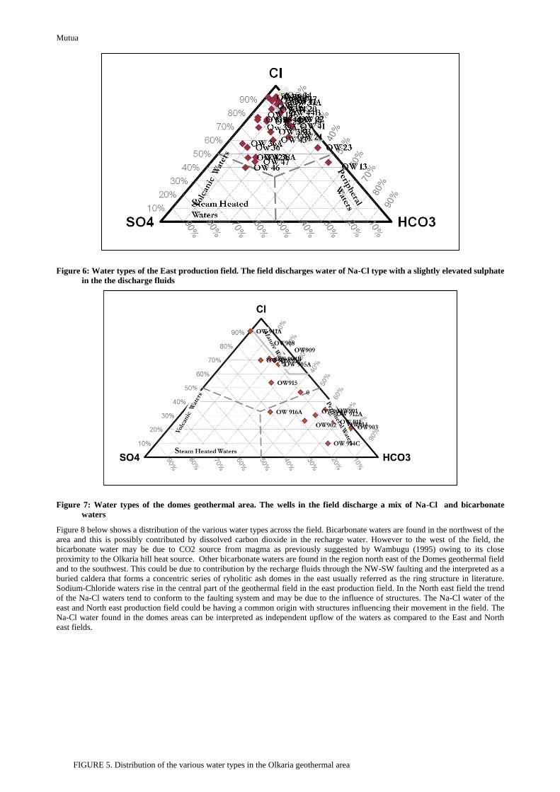
The relative abundance of chloride, sulfate and bicarbonate plots show that wells in the Olkaria East production field and in Olkaria
Northeast discharge sodium-chloride type water while the Olkaria West has the bicarbonate type. Wells in the Olkaria Central and
Domes fields discharge a mixture of chloride and bicarbonate end- member water. Kamunya, (2014)
Figures 5-7 below shows the water types in the Olkaria geothermal area
Figure 5: The Olkaria north east production field water type. This is predominantly Na-Cl waters
Mutua
Figure 6: Water types of the East production field. The field discharges water of Na-Cl type with a slightly elevated sulphate
in the the discharge fluids
Figure 7: Water types of the domes geothermal area. The wells in the field discharge a mix of Na-Cl and bicarbonate
waters
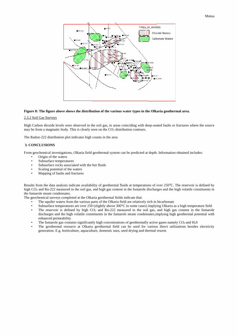
Figure 8 below shows a distribution of the various water types across the field. Bicarbonate waters are found in the northwest of the
area and this is possibly contributed by dissolved carbon dioxide in the recharge water. However to the west of the field, the
bicarbonate water may be due to CO2 source from magma as previously suggested by Wambugu (1995) owing to its close
proximity to the Olkaria hill heat source. Other bicarbonate waters are found in the region north east of the Domes geothermal field
and to the southwest. This could be due to contribution by the recharge fluids through the NW-SW faulting and the interpreted as a
buried caldera that forms a concentric series of ryholitic ash domes in the east usually referred as the ring structure in literature.
Sodium-Chloride waters rise in the central part of the geothermal field in the east production field. In the North east field the trend
of the Na-Cl waters tend to conform to the faulting system and may be due to the influence of structures. The Na-Cl water of the
east and North east production field could be having a common origin with structures influencing their movement in the field. The
Na-Cl water found in the domes areas can be interpreted as independent upflow of the waters as compared to the East and North
east fields.
FIGURE 5. Distribution of the various water types in the Olkaria geothermal area
Mutua
Figure 8: The figure above shows the distribution of the various water types in the Olkaria geothermal area.
2.3.2 Soil Gas Surveys
High Carbon dioxide levels were observed in the soil gas, in areas coinciding with deep-seated faults or fractures where the source
may be from a magmatic body. This is clearly seen on the CO2 distribution contours.
The Radon-222 distribution plot indicates high counts in the area
3. CONCLUSIONS
From geochemical investigations, Olkaria field geothermal system can be predicted at depth. Information obtained includes:
• Origin of the waters
• Subsurface temperatures
• Subsurface rocks associated with the hot fluids
• Scaling potential of the waters
• Mapping of faults and fractures
Results from the data analysis indicate availability of geothermal fluids at temperatures of over 2500C. The reservoir is defined by
high CO2 and Rn-222 measured in the soil gas, and high gas content in the fumarole discharges and the high volatile constituents in
the fumarole steam condensates.
The geochemical surveys completed at the Olkaria geothermal fields indicate that:
• The aquifer waters from the various parts of the Olkaria field are relatively rich in bicarbonate
• Subsurface temperatures are over 250 (slightly above 300°C in some cases) implying Olkaria as a high temperature field
• The reservoir is defined by high CO2 and Rn-222 measured in the soil gas, and high gas content in the fumarole
discharges and the high volatile constituents in the fumarole steam condensates,implying high geothermal potential with
enhanced permeability
• The fumarole gas contains significantly high concentrations of geothermally active gases namely CO2 and H2S
• The geothermal resource at Olkaria geothermal field can be used for various direct utilizations besides electricity
generation. E.g. horticulture, aquaculture, domestic uses, seed drying and thermal resorts
Mutua
REFERENCES
Einar G: Importance of Chemistry in Geothermal Exploration and Utilization, Proceedings Workshop for Decision Makers on
Direct Heating Use of Geothermal Resources in Asia, organized by UNU-GTP, TBLRREM and TBGMED, in Tianjin, China, 11-
18 May, 2008
Fridriksson, Th., Ármannsson, H., Feucht, C., Gudmundsson, G., and Gylfadóttir, S.S. : Chemical constraints on geothermal power
production in the greater olkaria geothermal area: scaling and corrosion potential and non-condensable gases, Report 5,
February/May, 2012
Lagat, J.,Stefan, A., Hjalti, F. Geology, Hydrothermal Alteration and Fluid Inclusion Studies of Olkaria Domes
Geothermal Field, Kenya. Proceedings World Geothermal Congress 2005 Antalya, Turkey, 24-29 April 2005
Karingithi, C.: Geochemical characteristics of the greater olkaria geothermal field, in Kenya, United Nations University-
Geothermal Training Programme Reports 2000 Orkustofnun, Grensásvegur 9, Number 9IS-108 Reykjavík, Iceland, 2000
Wambugu, J.M.: Geochemical update of Olkaria West geothermal field. Kenya Power Company, Ltd., internal report, 40 pp, 1995
Kamunya, M.K : Update of the Olkaria Geochemical conceptual Model, Internal Report, Internal Report, 2014
Arno´ rsson, S.,. bjarnason, j. o¨ , Giroud, N., Gunnarsson, I., . Stefa´ nsson, A. : Sampling and analysis of geothermal fluids
institute of earth sciences, university of iceland, reykjavı´k, Iceland, 2006
Truesdell, A.H.: Summary of Section III. Geochemical Techniques in Exploration. Second
United Nations Symposium on the Development and Use of Geothermal Resources, San Francisco,
pp. 53–79, 1976
Farrar, C.D., Sorey, M.L., Evans, W.C., Howle, J.F., Ken, B.D., Kennedy, B.M., King, C.Y. &
Southon, J.R.: Forest-killing diffuse C02 emission at Mammoth Mountain as a sign of magmatic unrest. Nature 376, 675-678, 1995
Fournier, R.O. : Chemical geothermometers and mixing models for geothermal systems.
Geothermics, 5, 41–50, 1977 Zhong-he, P. and A, Halldór. : Analytical Procedures and Quality Assurance for Geothermal Water Chemistry, United Nations
University Geothermal Training Programme Report, 2005 Halldor, A: Application of geochemical methods in geothermal exploration, Short Course V on Exploration for Geothermal
Resources, organized by UNU-GTP, GDC and KenGen, at Lake Bogoria and Lake Naivasha, Kenya, Oct. 29 – Nov. 19,
2010. Ouma, P.A : Reservoir engineering report for Olkaria Domes field. Kenya Electricity Generating Company Ltd., internal report,
54 p