an update on work related to biogeographic criteria for ... · biogeographic criteria for the...
TRANSCRIPT

An Update on Work Related to Biogeographic Criteria for the Classification of
Open and Deep Ocean Areas
– A joint expert effort under the co-sponsorship of UNESCO, IOC, IUCN, Australia, Canada, Mexico and the J.M. Kaplan Fund –
SIDE EVENT
United Nations Informal Consultative Process on Oceans and the Law of the Sea
Eight Meeting
United Nations, New York, 25 June 2007
Background Notes

Table of Contents 1. Introduction
1.1 Why biogeographic classification? 1.2 Background to the Mexico Workshop
2. Core concepts in a biogeographic classification system for the high seas
2.1 Relevant present approaches to classification of marine environments 2.2 Criteria for a classification framework for the high seas 2.3 Practical issues
3. Pelagic Subgroup: Considerations and Conclusions 4. Benthic Subgroup: Considerations and Conclusions 5. Envisaged next steps

1. Introduction 1.1 Why biogeographic classification? Biogeographic classification systems are widely viewed as essential tools for integrated oceans management. They assist in understanding how and where taxa are distributed and in marking the boundaries between oceanographic regimes. To the extent that they reflect biological units with a degree of common history and coherent response to perturbations and management actions, they provide a basis by which the spectrum of life on Earth can be studied, conserved, and sustainably and equitably managed. Unless we have knowledge of the distribution of the elements of marine biodiversity, and can agree upon a framework for classification of areas, efforts to assess the impacts of human activities on our world oceans will be hampered. Specifically, we shall not be able to assess which habitats, communities and taxa are subject to disproportionate impact, because of concentration of human activities, rarity, or limited extent of distribution. In addition the regions identified by the classification are a necessary precondition for identification of Representative Areas within each zone. In the high seas, biogeographic classification systems are far less developed than in terrestrial, coastal and continental shelf areas. Here our goal is to define a set of basic principles and a framework for the recognition and classification of coherent biogeographic regions of the high seas, where no such agreed system has been developed. The basic principles should allow us to spatially delineate separate areas that have recognizably different and predictable taxonomic compositions. Our confidence in the delineation of such areas will increase if it is possible to link them to oceanographic processes or geophysical structures that contribute to making them definably separate, and suggest mechanisms by which their relative homogeneity could have arisen and could be maintained. Our primary interest is in the open ocean (high seas) and deep seabed area outside national exclusive economic zones (EEZ or comparable zone) and oceanward of continental shelves. Where clearly identifiable high seas biogeographic zones continue inside EEZs, it makes sense for experts describing the zones to point out the biological contiguity within and outside the EEZ, even if the governance systems for the different parts of the biogeographic zones may be different. In our approach to a classification system for supporting the selection of Representative Areas, we are specifically excluding: distinctive (unique) areas, hotspots (of whatever kind including areas of high species diversity), and ecologically and biologically significant areas. We are also not considering current environmental conditions or ‘naturalness’, nor threats to marine environments, habitats, or their communities, or current or potential ‘end-uses’ of marine environments.

1.2 Background to the Mexico Workshop A workshop in Mexico City in January 2007, coordinated by the University of Mexico (UNAM), the National Commission for the Study and Utilization of Biodiversity (CONABIO) and the Institute of Marine Sciences and Limnology, Mexico, UNESCO, IOC and IUCN and funded by Australia, Canada, Mexico and the J.M. Kaplan Fund provided an essential step towards developing a comprehensive biogeographic classification of open ocean and deep seabed areas beyond national jurisdictions based on the latest information made available from science experts. The workshop built on existing relevant global and regional collaborative research programmes, as well as the experience of coastal states and regional management bodies in developing representative classification systems. This workshop convened an international group of 30 scientific experts and observers and support staff with the objectives of:
a) reporting and evaluating on progress to date in developing and applying biogeographic classification systems;
b) identifying basic principles for the choice, adoption and application of biogeographic classification systems where no such generally agreed system has been developed;
c) discussing methods to describe and delineate distinct areas of the deep seabed; d) developing preliminary maps depicting potential boundaries for biogeographic
realms, provinces and ‘ecological regions’ in the open ocean, and, to the extent possible, for the deep seabed, through the use of GIS and other mapping tools;
e) prioritizing relevant research and practical needs to further advance work on biogeographic classification systems for the deep seabed and open ocean; and
f) promoting information exchange and capacity development among scientists working on similar projects within national and regional waters.
2. Core concepts in a biogeographic classification system for the high seas 2.1 Relevant present approaches to classification of marine environments Relevant present approaches to classification of marine environments include:
• Taxonomic methods: the broad global patterns of taxonomic distributions are well known, though subject to revision as new genetic methods are applied and bio-exploration of the seas continues. Although detailed information on species’ occurrences is available for privileged areas of the globe, for the vast majority of the oceans such information is sparse. Whatever the level of information available, coverage is much better for some types of organisms (e.g. commercially exploited finfish, seabirds, marine mammals) than others (e.g. zooplankton, many macro-invertebrates). At regional scales it is impossible to directly conduct comprehensive biological surveys, and it is necessary to extrapolate relationships between biota and the physical environment. Thus taxonomic methods and
surveys alone are however not sufficient to fully classify the biodiversity of the oceans such that representative areas can be selected for protection.
• Physiognomic methods: In the pelagic realm, the broad scale distributions of
ocean gyres, transition zones and coastal currents are well known, and in the benthic environment the geomorphology of the oceans is being revealed by a variety of mapping technologies. Geophysical (physiographic and oceanographic) factors are relatively easy to quantify and map at regional scales, and can define habitat characteristics coarsely. Where community types have been biogeographically defined, geophysical factors can predict at least major community types fairly accurately. Thus in better studied areas physiognomic data can provide a second level of calibration for mapping representative areas, and this general approach is now in widespread use in coastal and shelf waters.
• Ecological geography: Definition of biomes or ecosystem types helps to define
epipelagic boundaries and productivity regimes. However, that is only one aspect of the patterns of marine biodiversity, and cannot alone form the general basis for delineating marine ecozones for selection of representative marine areas.
• Political or governance management regions: Although RFMOs and other
management units may be somewhat internally homogeneous in fish fauna, their boundaries cannot be counted on to coincide with any major discontinuities in species composition. Rather, boundaries also reflect the limits of legal agreements and historic patterns of fisheries. Hence the boundaries may be set rather arbitrarily compared to the structure of biogeographic community structure, particularly of the full range of biodiversity, and not just the major exploited fish stocks.
2.2 Criteria for a classification framework for the high seas Following are agreed criteria for a classification framework for the high seas:
1. There are sound reasons to consider the pelagic and benthic environments separately. The pelagic world is fully three dimensional, whereas to a first approximation, the benthic world can be analyzed in terms of two dimensional properties. Their scales of predictability of habitat features are also different in space and time, Although the two environments exchange energy and organisms, their complements of taxa, size-spectra of species, life-spans of species, and communities of organisms are almost entirely different.
2. The goal is to achieve a classification of regions for the selection of representative
areas. By definition therefore, we cannot base it upon unique characteristics of distinctive areas or upon individual focal species.
3. An ecological classification system that results only in the recognition of biomes fails to express taxonomic identity, which is essential to our desired system.
As a consequence of 1-3 above, it is necessary to use the taxa themselves to delineate areas, otherwise we default to a classification of biomes or ecosystem ‘types’ or just geopolitical constructs. In fact, the definition of areas by taxa inevitably becomes the first level of a classification.
4. It is necessary to recognize both ecosystem structures and processes in defining habitat characteristics and their arrays of species.
5. Useful classifications are almost always hierarchical – in which like entities are
progressively grouped and distinguished. However, the number of divisions required in a hierarchy is less clear.
Considering principles 1-5 as a basis to define and map biogeographic regions and select representative areas requires dealing with a ‘mixed’ system, that is – one that combines taxonomic, ecological and physiographic approaches and factors. 2.3 Practical Issues Biogeographic systems will be meaningful if the community structure changes in some marked and consistent way in response to natural or anthropogenic forcers. To the extent that a few species predominantly determine ecosystem structure and regulate ecosystem function, it is systematic changes in their abundance that helps delineate functional biogeographic units, whether the biomes (the types of ecosystem structure and function characteristic of the zone) or lists of species have changed greatly or not. Any factor used in a hierarchical biogeographic classification system should enter the hierarchy at the scale at which it affects species’ distributions. However, we have not defined at what spatial scale our approach will be applied. Similarly the number of levels in each hierarchy is not decided, although it is clear that there will certainly be more in the benthic environment – reflecting its greater heterogeneity. Also even when maps of representative areas are produced for the high seas, there will remain unaddressed requirements for finer scale data. Marine species compositions vary over time scales from days (seasonal phytoplankton blooms), through decades (meteorological regime shifts, changes in fisheries and vent communities), to long-term climate change and global warming. Marine boundaries and conditions are variable in both space and time, and any mapping of representative areas can only be one ‘snapshot’ of current and recent historical knowledge. Uses of the biogeographic classification system must acknowledge that most boundaries are “fuzzy” particularly in the pelagic environment. The concept of Representation is only one part (though arguably the most important part) of the conservation-management agenda for the high seas. The concepts of distinctive

areas, redundancy of conservation efforts, connectivity, migration patterns etc. are not considered here, but must be considered in an integrated approach to conservation and management. 3. Pelagic Subgroup: Considerations and Conclusions The conceptual discussion centered on the observation that existing biogeographic classification schemes (marine and terrestrial) can be grouped into two broad approaches:
a. taxonomic – A system based on similarities and differences in organisms or communities of organisms (aka phylogenetic). E.g. realms, provinces;
b. physiognomic – A system based on similarities and differences in habitats/functions/ecological processes. E.g. biomes, habitats, ecosystems (where “habitats” can include abiotic information such as depth and currents).
From a conservation perspective, the goal is to differentiate spatial units that capture species and ecological processes that could not be protected through implementation of conservation measures in other places. Conservation considerations provide justifications to protect composition, structure and function of ecosystems. Composition and community structure are reflected in a taxonomic approach, whereas marine habitats, and ecological functions and processes are more closely allied to physiognomic classifications. A taxonomic classification would be ideal for driving efforts towards conservation of representative slices of the oceans. However, it is likely that there are sufficient gaps and inconsistencies in data on taxon presences and geographic coverage to preclude a purely taxonomic system from being drawn up. Notwithstanding the inadequacies of data on species occurrences, the close linkages between the two approaches at finer spatial and temporal scales should enable construction of a classification system that uses available information from both taxonomic and functional datasets to create a coherent bio-geographical classification system. The group decided to aim to produce a classification that followed both taxonomic and functional classes, and would hope that such a classification would have good predictive strength for taxonomic patterns even where data on species occurrences are currently scarce. The expert discussion centered around making sure the classification system would capture:
- core areas of gyres - equatorial upwelling - upwelling zones at basin edges - important transitional areas – including convergence and divergence areas
These have distinct assemblages and usually some distinct species. Some transitions are clear boundaries between distinct zones, although the locations of the boundaries often move through time. Other transition zones are a gradient from one type of zone to another with mixing of features across the zone. Many of these boundary/transitional areas are

critical in pelagic/benthic coupling. Some areas only appear to be transitional, because of a lack of data to assign an area to any specific zone. These latter areas should be the focus of additional study. It was generally felt that there is good overlap of what is known of species’ distributions with oceanographic/physical processes that characterize the taxonomic units. There is also a clear link between some of these areas and features of ecosystem function and/or productivity, and good parallels in some of the taxonomic systems and the systems based on productivity. In the practical tasks of delineating the candidate zones, it was generally agreed that:
1. any classification should continue across EEZ boundaries into adjacent waters, thereby ensuring we capture important systems such as many boundary currents;
2. small slivers of high seas above 200m should not be treated as special for this
purpose;
3. the group would NOT continue any classification into the semi-enclosed ocean basins of the Caribbean, Gulf of Mexico, Mediterranean, Black Sea, etc, which were outside the mandate of the “High Seas”, even if they were still “deep seas”;
4. in dealing with migratory species in the taxonomic aspects of this classification
system, four types of “migratory” species were recognized as possibly needing different treatment:
- species that shift between multiple locations (e.g. humpbacks); - species that are attached to one site for one life history activity and then
move to another site for another activity (i.e. species with distinct feeding and breeding grounds);
- species undertaking more constant movements; - species of limited motility that are captives of oceanography These four types of migratory species are all tied to oceanographic processes and should be reflected in water-mass, gyral, boundary/transitional zones.
Each of these types of species should be captured in this system – the fixed points or end locations matching well with single biogeographic locations and the more constant movements of limited motility species being captured by the general spatial patterns of ocean currents and water masses represented in our system.

Applying the above principles and reasoning, in its first iteration the map for pelagic ecoregions included 29 provinces listed below: 1. Agulhas Current 2. Antarctic 3. Antarctic Polar Front 4. Arctic 5. Benguela Current 6. California Current 7. Canary Current 8. Eastern Tropical Pacific 9. Equatorial Atlantic 10. Equatorial Pacific 11. Gulf Stream 12. Humboldt Current 13. Indian Ocean Gyre 14. Indian Ocean Monsoon Gyre
15. Kuroshio 16. Leuwin Current 17. Malvinas Current 18. Non-gyral Southwest Pacific 19. North Atlantic Transitional 20. North Central Atlantic Gyre 21. North Central Pacific Gyre 22. North Pacific Transitional 23. Somali Current 24. South Central Atlantic Gyre 25. South Central Pacific Gyre 26. Subantarctic 27. Subarctic Atlantic 28. Subarctic Pacific 29. Subtropical Convergence
30.

4. Benthic Subgroup: Considerations and Conclusions The Benthic Subgroup began with a one-level classification system (provinces), based on a definition of ecological provinces developed at the workshop. The definition was intended to capture biota with shared evolutionary history and some levels of endemism with provinces. It was decided to move to a biogeographic classification system so by relying on habitat/functional classification systems to initially delineate provinces and then overlaying available taxonomy on habitat patterns to refine these patterns. . The following benthic factors and their subdivisions likely to be related to biogeography at the scale of provinces were identified as:
1) Depth zones: - Upper bathyal - Lower bathyal - Abyssal - Hadal
2) Hydrographic settings:
- Water mass - Transport pathways
3) Geomorphology:
- Trenches and troughs - Abyssal basins - Topographic highds (seamounts, ridges, plateaus, islands) - Slopes - Shelves
4) Chemosynthetic ecosystems:
- Vents - Seeps - Whale falls
The Subgroup decided to focus on cores of provinces because boundaries were likely to be poorly known and controversial. Mapping would begin with the following habitat units/realms:
- Abyssal basins - Hydrothermal vents - Topographic highs
Mapping would have two stages; delineating all areas of the high seas that were in each habitat unit/realm, and then deciding which areas of a given realm comprised a similar

biogeographic unit for the purposes outlined in the conceptual section of this process (section 2). Specific tasks were assigned to individual experts for map and data synthesis, gap identification and scientific justification after the workshop with regard to the above-mentioned habitat units/realms as well as Bathyal Zone, the Hadal Zone and Antarctic. Moreover, it was decided that hydrographic settings represented a major gap, which also required an additional specific workshop.
Box: The specific example of the hadal provinces Maps and syntheses of Vinogradova (1997) and Sokolova (1997) were used as a starting point. Factors guiding (or leading to) designation of centers of abyssal and hadal provinces are:
1) Bathymetry: Abyssal zone, based on seabed geomorphology and faunal distributions, extends from 3000-6000 m; the hadal occurs at depths greater than 6000 m (Vinogradova, 1997).
2) Distribution patterns and regional similarity of “true abyssal species” and “endemic hadal species” are used as indicators of abyssal and hadal provinces: species found at abyssal depths (3000-6000 m) but not shallower than 3000 m (Vinogradova, 1997) are considered true abyssal species, while those found exclusively deeper than 6000 m (56% of all species found in the hadal zone) are considered hadal endemics (Vinogradova, 1997).
3) Patterns of oceanic productivity: the “near continental and equatorial eutrophic” and “central gyre oligotrophic” abyssal areas of Sokolova (1997) are used to define additional centers of abyssal provinces. Community structure, trophic composition, and even higher taxonomic composition differ between eutrophic and oligotrophic abyssal areas (Sokolova, 1997; Smith and Demopoulos, 2003).
Key points:
• Zoogeography of the abyss depends on three major factors: depth, latitude (or climatically controlled zones of productivity and circulation) and distance from continental margins (which also influences productivity).
• Abyssal zoogeography based purely on topography and hydrologic characteristics of bottom waters (e.g., temperature) is not supported by faunal distribution patterns (Vinogradov, 1997).
• Midocean ridges (including the Hawaiian Ridge) are important zoogeographic barriers for the “true abyssal” fauna (i.e., species restricted to >2500 m).
• Vinogradov (1997) divides the abyssal (3000-4000 m) into eight provinces (organised in three regions and six subregions). For true abyssal species, similarity is less than 10% (usually much less) between provinces.
• Based on Sokolova’s (1997) trophic analyses, abyssal province should be further subdivided at least into eutrophic and oligotrophic areas because only 13% of species from her “continental eutrophic” abyssal areas penetrated into the “oligotrohic” areas, and trophic composition and biomass patterns varied dramatically between these zones.
• Taxa with numerous species with large vertical (bathymetric) ranges have broader horizontal ranges (with some species occurring widely across provinces and oceanic basins. Taxa characterized by narrow vertical ranges have high levels of endemism within provinces.
• Taxa with numerous true abyssal species, narrow bathymetric ranges, high levels of endemism in the abyss, and hence evidence of abyssal adaptive radiation include (Vinogradova, 1997):
o Isopoda (especially Asselota) o Echiura o Hexactinellida o Phanerozoa (Asteroidea) o Elasipada (Holothuroidea)
• For taxa in which <50% of species are true abyssal species, the abyssal fauna is mainly a gradually diminishing remnant of mainly bathyal species (Vinogradova, 1997; cf. Rex et al., 2004).
• Zoogeography of the hadal zone is based primarily on depth (i.e., areas trenches deeper than 6000 m) and geographic isolation forms other trench-depth habitats (Vinogradova, 1997).
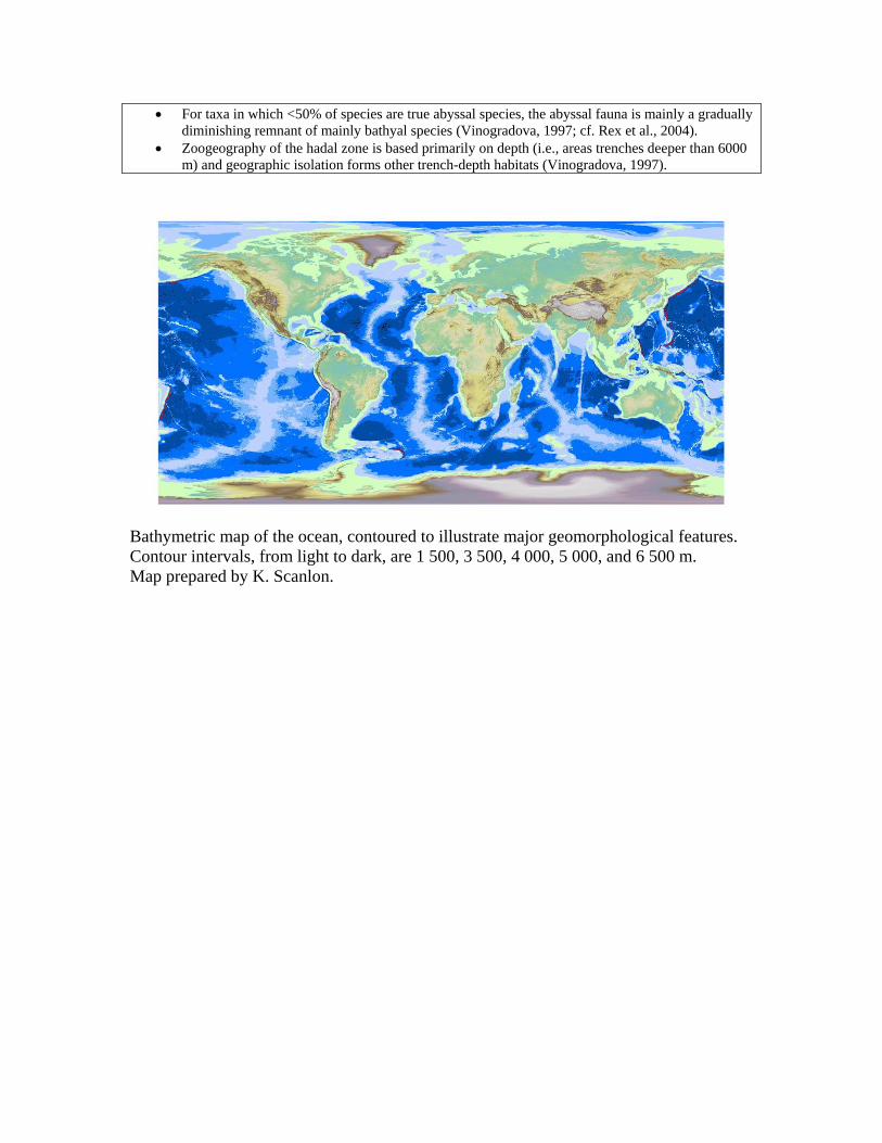
Bathymetric map of the ocean, contoured to illustrate major geomorphological features. Contour intervals, from light to dark, are 1 500, 3 500, 4 000, 5 000, and 6 500 m. Map prepared by K. Scanlon.

Known hydrothermal vent provinces (information from C.L. Van Dover) Base map with showing only 800-3 500 m bathymetry Map prepared by L Watling and K. Scanlon.
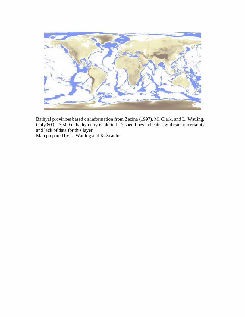
Bathyal provinces based on information from Zezina (1997), M. Clark, and L. Watling. Only 800 – 3 500 m bathymetry is plotted. Dashed lines indicate significant uncertainty and lack of data for this layer. Map prepared by L. Watling and K. Scanlon.

Abyssal Province centers (approx. 3 000 – 6 000 m) based on information from Vinogradova (1997) and Smith (unpublished). Base map showing 3 500- 6 500 m bathymetry (blue). Areas in the Pacific delimited by dashed lines indicate likely province changes due to changes in surface primary production. Map prepared by L. Watling and K. Scanlon.

Hadal provinces of the world based on information from Vinogradova (1997), using base map showing only depths > 6 500 m. Map prepared by L. Watling and K. Scanlon. 5. Envisaged next steps As states in the introduction, biogeographic classification is an important tool for management. Equally, findings based on biogeographic classification, combined with other relevant information, such as ecological criteria, can provide important information for policy-making. The group that met in Mexico will continue its work towards the production of maps of biogeographic units for the various benthic factors. These maps are intended to contribute to the planned meeting of the Convention on Biological Diversity on biogeographic and ecological criteria scheduled to take place in Portugal in October 2007. These maps will hopefully inform relevant decision-making processes on oceans and the law of the sea, in particular, the United Nations Informal Consultative Process on Oceans and the Law of the Sea, the Ad Hoc Working Group on issues related to biodiversity in areas beyond national jurisdiction under the United Nations General Assembly and the General Assembly itself. Further scientific work in this area along the Mexico Workshop and follow-up is much needed, and will depend on the availability of financial resources.
- - -