an yin and t. mark harrison - university of california...
TRANSCRIPT

Annu. Rev. Earth Planet. Sci. 2000. 28:211–80Copyright q 2000 by Annual Reviews. All rights reserved
0084–6597/00/0515–0211$14.00 211
GEOLOGIC EVOLUTION OF THE HIMALAYAN-TIBETAN OROGEN
An Yin and T. Mark HarrisonDepartment of Earth and Space Sciences and Institute of Geophysics and PlanetaryPhysics, University of California, Los Angeles, California 90095–1567; e-mail:[email protected], [email protected]
Key Words orogenic development, continental collision, Himalaya, Tibetanplateau
Abstract A review of the geologic history of the Himalayan-Tibetan orogensuggests that at least 1400 km of north-south shortening has been absorbed by theorogen since the onset of the Indo-Asian collision at about 70 Ma. Significant crustalshortening, which leads to eventual construction of the Cenozoic Tibetan plateau,began more or less synchronously in the Eocene (50–40 Ma) in the Tethyan Himalayain the south, and in the Kunlun Shan and the Qilian Shan some 1000–1400 km in thenorth. The Paleozoic and Mesozoic tectonic histories in the Himalayan-Tibetan orogenexerted a strong control over the Cenozoic strain history and strain distribution. Thepresence of widespread Triassic flysch complex in the Songpan-Ganzi-Hoh Xil andthe Qiangtang terranes can be spatially correlated with Cenozoic volcanism and thrust-ing in central Tibet. The marked difference in seismic properties of the crust and theupper mantle between southern and central Tibet is a manifestation of both Mesozoicand Cenozoic tectonics. The former, however, has played a decisive role in localizingTertiary contractional deformation, which in turn leads to the release of free waterinto the upper mantle and the lower crust of central Tibet, causing partial melting inthe mantle lithosphere and the crust.
INTRODUCTION
Mountain belts created by continent-continent collision are perhaps the most dom-inant geologic features of the surface of the Earth (Dewey & Burke 1973). TheAppalachian belt in North America, the Ural mountains in central Eurasia, andthe Qinling-Dabie-Shandong belt in east-central Asia are some of the best exam-ples, each extending for thousands of kilometers along strike. A great deal ofattention has been paid to the genesis of these orogenic systems since the devel-opment of plate tectonics some 35 years ago, largely owing to the fact that con-tinent-continent collision is the dominant and most efficient process in formingthe supercontinents, which profoundly affect the geologic and biologic evolution
Ann
u. R
ev. E
arth
Pla
net.
Sci.
2000
.28:
211-
280.
Dow
nloa
ded
from
arj
ourn
als.
annu
alre
view
s.or
gby
Ins
titut
e G
eolo
gy &
Geo
phys
ics
on 0
3/16
/09.
For
per
sona
l use
onl
y.

212 YIN n HARRISON
of the Earth. The youngest and arguably most spectacular of all the continent-continent collisional belts on Earth is the Himalayan-Tibetan orogen, occupyingthe east-west trending, high-altitude Himalaya and Karakorum ranges in the southand the vast Tibetan plateau to the north (Figure 1; Figure 2, color insert). Thisorogenic system was largely created by the Indo-Asian collision over the past70–50 Ma, and is part of the greater Himalayan-Alpine system that extends fromthe Mediterranean Sea in the west to the Sumatra arc of Indonesia in the eastover a distance of more than 7000 km. This extraordinarily long and complexlyamalgamated belt was developed by the closure of the Tethys oceans betweentwo great land masses since the Paleozoic: Laurasia in the north and Gondwanain the south (Hsu et al 1995, Sengor & Natal’in 1996).
The Himalayan-Tibetan orogen and its neighboring regions in east Asia areideal places for the study of continent-continent collision for several reasons.First, the orogen is active so that many geologic relationships can be demonstrateddirectly using the methods of neotectonic studies (Armijo et al 1989, Holt et al1995, Lacassin et al 1998, Van der Woerd et al 1998, Bilham et al 1997, Larsonet al 1999, Shen et al 1999). Second, the plate-boundary history is well known,so the cause of intracontinental deformation can be quantitatively defined as atime-dependent, boundary-value problem (Peltzer & Tapponnier 1988, Houseman& England 1996, Royden 1996, Royden et al 1997, Kong & Bird 1996, Peltzer& Saucier 1996, Kong et al 1997). Third, collision processes have produced avariety of geologic features such as large-scale thrust, strike-slip and normal faultsystems (Tapponnier et al 1986, Burg & Chen 1984, Burchfiel et al 1992, Yin etal 1994), leucogranite magmatism (Harrison et al 1998b), widespread volcanism(Deng 1989, Arnaud et al 1992, Turner et al 1993, Chung et al 1998, Deng 1998),regional metamorphism (Le Fort 1996, Searle 1996), and formation of intracon-tinental and continental-margin oceanic basins (Song & Wang 1993, Brias et al1993, Li et al 1996). All of the preceding geologic features and processes maybe useful as proxy indicators in establishing the deep earth conditions involvedin the dynamics of continent-continent collision.
Because of its immense size and high elevation, the geologic evolution of theHimalayan-Tibetan orogen is also thought to have played a critical role in con-trolling global climate change (Ruddiman & Kutzbach 1989, Molnar et al 1993,Quade et al 1995, Harrison et al 1998a, cf. Ramstein et al 1997). The climatechange, in turn, may have affected erosion rate, and thus altered the dynamics ofthe Himalayan-Tibetan orogenic system (Beaumont et al 1992) and its growthpattern (Avouac & Burov 1996). It is this large-scale interaction between litho-spheric deformation and atmospheric circulation that potentially makes studies ofthe Himalayan-Tibetan orogen of greater significance than simply matters of intra-continental deformation induced by continental collision.
In the last three decades, many geologic and geophysical investigations havebeen conducted in the Himalayan-Tibetan orogen, and have resulted in numeroussyntheses dealing with both active tectonics and the overall geologic evolutionof the system (Chang & Zheng 1973; Dewey & Burke 1973; Allegre et al 1984;
Ann
u. R
ev. E
arth
Pla
net.
Sci.
2000
.28:
211-
280.
Dow
nloa
ded
from
arj
ourn
als.
annu
alre
view
s.or
gby
Ins
titut
e G
eolo
gy &
Geo
phys
ics
on 0
3/16
/09.
For
per
sona
l use
onl
y.
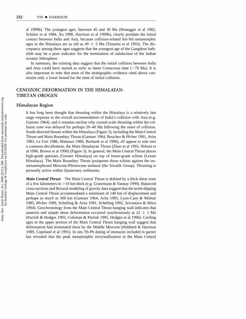
Major Cenozoic basins in Asia developed during Indo-Asian collision
v vv v
Major Cenozoic volcanic fields in Asia developed during Indo-Asian collision
Cenozoic dike swarmsemplaced during Indo-Asian collision
vv
v
vv
vvvv
v
vv
vv
vv
vv
vv
vv
v
vv
vv
vv
v
v vv v
v v
vv
Philippine SeaPlate
Oki
naw
a tro
ugh
Japan Sea
Taiwan
Haina
18-14 Ma
40-1 Ma
40-35 Ma
23 Ma
57 Ma
< 20 Ma
v
< 20 Mav v
v
30 Ma
35-30 Ma
16 Ma
< 8 Ma
v
vv
v v v
< 20 Ma
v
v v
< 5 Ma
v
< 25 Ma
Li Xian
Qaidam Basin Huabeibasin
Jiali fault
Bohai Bay
KJFZ
Tian Shan
India
Tibetan Plateau
OrdosBlock
Shan
xi
grab
en
Yinc
huan
Ri
ft
Tanl
u fa
ult s
yste
m
Baikal
Qilian Shan
Qinling fault
Tarim Basin
Red River fault
Kunlun fault
system
Karakarum
fault
Altyn Tagh fault
40o
30o
20o
40o
30o
20o
80o
90o 100o
110 o 120o 130o
Mongolia
Korea
Japa
n
Song
liao
Bas
in
Altai fault
South China
Talasso-Fergana fault
Bogdo fault
Taihang Shan fault
Lhasa
North China
JunggarBasin
Harbin
Yinchuan
Beijing
Yumen
Nan Shan
Hailaer Basin
Longmen Shan
Thrust Belt
Himalaya
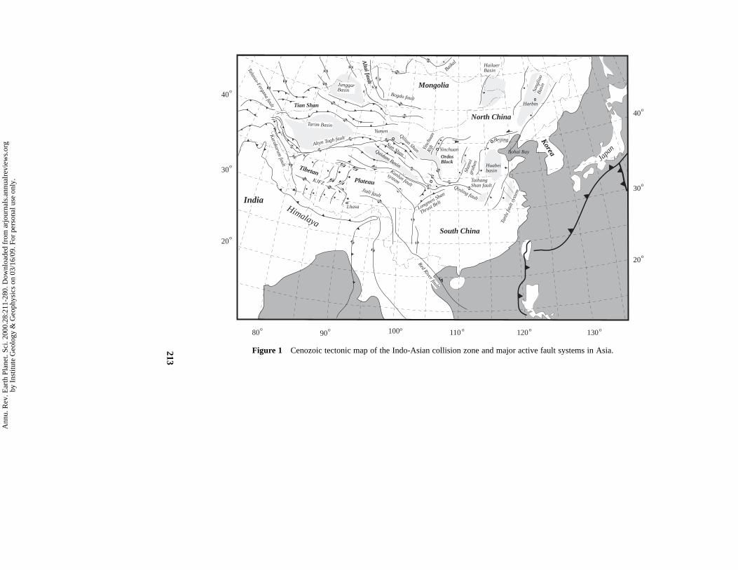
Figure 1 Cenozoic tectonic map of the Indo-Asian collision zone and major active fault systems in Asia.213
Ann
u. R
ev. E
arth
Pla
net.
Sci.
2000
.28:
211-
280.
Dow
nloa
ded
from
arj
ourn
als.
annu
alre
view
s.or
gby
Ins
titut
e G
eolo
gy &
Geo
phys
ics
on 0
3/16
/09.
For
per
sona
l use
onl
y.
214 YIN n HARRISON
Molnar 1984; Tapponnier et al 1986; Dewey et al 1988, 1989; Burchfiel & Royden1991; Harrison et al 1992, 1998a; Molnar et al 1993; Zhao et al 1993; Avouac &Tapponnier 1993; Hsu et al 1995; Nelson et al 1996; Owens & Zandt 1997;England & Molnar 1998; Larson et al 1999; Xu et al 1998). The goal of thisarticle is to provide a coherent picture of how the Cenozoic Himalayan-Tibetanorogen has evolved. To achieve this, we must have a general understanding ofthe configuration of the amalgamated Eurasian continent immediately prior to theIndo-Asian collision; this information can be used as both a strain marker and aninitial condition to determine where, when, and how the intracontinental defor-mation proceeded in Asia during the Cenozoic. Therefore, this review focusesfirst on the pre-Cenozoic geologic framework of the Himalayan-Tibetan orogen,and then provides a systematic synthesis of the history of major Cenozoic struc-tures and the occurrence of associated metamorphic, igneous, and sedimentaryrock units. The latter forms the observational basis for the interpreted spatial andtemporal evolution of the orogen.
PALEOZOIC AND MESOZOIC TECTONICS
The Himalayan-Tibetan orogen was built upon a complex tectonic collage thatwas created by sequential accretion, from north to south, of several microconti-nents, flysch complexes, and island arcs onto the southern margin of Eurasia sincethe early Paleozoic (Chang & Zheng 1973, Allegre et al 1984, Sengor & Natal’in1996, Yin & Nie 1996). Because of this complex early history, it is effectivelyimpossible to decipher the Cenozoic tectonic history of the Himalayan-Tibetanorogen without first knowing the crustal composition, pre-Cenozoic structuralconfiguration, and sequence of geologic events associated with the formation ofeach of these individual tectonic units. In the following section, we commentbriefly on the pre-Cenozoic geology of major terranes in the orogen (Figures 2and 3, color insert) and summarize the overall tectonic evolution of theHimalayan-Tibetan region prior to the Indo-Asian collision (Figure 4).
Himalaya
The Himalaya lie between the Indian shield to the south and the Indus-Yalu sutureto the north (Figure 2). They consist of three tectonic slices bounded by threenorth-dipping Late Cenozoic fault systems: the Main Boundary Thrust, the MainCentral Thrust, and the South Tibetan Detachment System (Figures 2 and 3).
The Lesser Himalaya is structurally the lowest slice. It is bounded at the baseby the Main Boundary Thrust and at the top by the Main Central Thrust, andconsists mainly of Precambrian clastic sediments and metasedimentary rocks(Brookfield 1993). The Greater (or High) Himalaya is bounded by the MainCentral Thrust below and the South Tibetan Detachment fault above (Burg &
Ann
u. R
ev. E
arth
Pla
net.
Sci.
2000
.28:
211-
280.
Dow
nloa
ded
from
arj
ourn
als.
annu
alre
view
s.or
gby
Ins
titut
e G
eolo
gy &
Geo
phys
ics
on 0
3/16
/09.
For
per
sona
l use
onl
y.

South China basement
South China basementwith Paleozoic cratonal sequence on below Triassic strata
Pamir pormotory
Pamir pormotory
Songpan-Ganzi
Remenant Ocean
Songpan-Ganzi
Remenant Ocean
(2) Early Ordovician-Carboniferous
(3) Triassic
(1) Cambrian-Early Ordovician
(a) Paelozoic-Meosozoic Evolution of the Lhasa and Qiangtagn Terranes
India Lhasa
Lhasa
Qiangta
ng
India
(4) Late Jurassic-Middle Cretaceous
India Lhasav v v
Huashixia forearc basin
Yushu forearc basin Eastern Qilian back-arc basin
Kunlun arc
Lhasa
v v v
Yushu forearc basin
India
Huashixia forearc basin
Eastern Qilian back-arc basin
Kunlun arc
North China
North China
Qiangtang
Central Qiangtangblueschist-bearing extensional core complexes
Northern Gondwana
Jurassic melange and flysch basin
Kohistan arc
Ladakh batholith
Gangdese batholith
Songpang-Ganzi Flysch Complex
Figure 4 Paleozoic-Mesozoic tectonic evolution of the Himalayan-Tibetan orogen.
215
Ann
u. R
ev. E
arth
Pla
net.
Sci.
2000
.28:
211-
280.
Dow
nloa
ded
from
arj
ourn
als.
annu
alre
view
s.or
gby
Ins
titut
e G
eolo
gy &
Geo
phys
ics
on 0
3/16
/09.
For
per
sona
l use
onl
y.

AKM suture
Jinsha suture
(b) Paelozoic-Meosozoic Evolution of the Kunlun and Qilian Terranes(1) Early Ordovician
(2) Early Devonian
Kunlun-Qaidam South Qilian Central Qilian
North China
(3) Carboniferous South Qilian suture Danghe Nan Shan suture Northern Qilian suture zone
Kunlun-Qaidam South Qilian Central Qilian
v v v v
v v v v
forarcbasin
accretionary wedge
North Qilian arc
North China
Kunlun-Qaidam South Qilian Central Qilian
North China
South Qilian suture Danghe Nan Shan suture Northern Qilian suture zone
Permian basaltsin Tarim
(4) Early Permian
South Qilian Central Qilian North China
South Qilian suture Danghe Nan Shan suture Northern Qilian suture zoneKudi back-arcbasin
Northern Kunlun
Southern Kunlun
Songpan-Ganzi oceanQiangtang
(5) Late Triassic
South Qilian Central Qilian North China
South Qilian suture Danghe Nan Shan suture Northern Qilian suture zoneKudi suture
Northern KunlunSouthern KunlunSongpan-Ganzi-Hoh Xil
Qiangtang Triassic foredeep deposits in Tarim
Figure 4 Paleozoic-Mesozoic tectonic evolution of the Himalayan-Tibetan orogen.
216
Ann
u. R
ev. E
arth
Pla
net.
Sci.
2000
.28:
211-
280.
Dow
nloa
ded
from
arj
ourn
als.
annu
alre
view
s.or
gby
Ins
titut
e G
eolo
gy &
Geo
phys
ics
on 0
3/16
/09.
For
per
sona
l use
onl
y.

HIMALAYAN-TIBETAN OROGEN 217
Chen 1984, Burchfiel et al 1992, Le Fort 1996) and comprises late Proterozoicto early Cambrian metasedimentary rocks (Parrish & Hodges 1996). The NorthHimalaya lies between the South Tibetan Detachment fault (Burchfiel et al 1992)and the Great Counter Thrust (Yin et al 1999a). It consists of late Precambrianto early Paleozoic sedimentary and metasedimentary rocks (Yin et al 1988, Burch-fiel et al 1992) and thick Permian to Cretaceous continental margin sequences(Brookfield 1993). All three tectonic slices are considered to be parts of the north-facing Himalayan passive continental margin, commonly known as the TethyanHimalaya, which developed from middle Proterozoic to Cretaceous times(Colchen et al 1982, Brookfield 1993). It appears that Late Cenozoic thrusting inthe Himalaya did not involve the Archean/Early Proterozoic gneissic basementthat is equivalent to the Indian Shield (Parrish & Hodges 1996).
The Himalayan passive continental margin was intruded by Cambrian to earlyOrdovician granites (Le Fort et al 1983), which may have been associated witheither supercontinent breakup (Murphy & Nance 1991, Hughes & Jell 1999) orfinal assemblage of Gondwana (Gaetani & Garzanti 1991, Meert & Van der Voo1997). Between the Ordovician and Permian, all three tectonic slices in the Him-alaya formed part of a stable continental platform (Brookfield 1993). In the Per-mian, rifting accompanied by the eruption of Panjal basalts began to develop inthe northern Himalaya. This phase lasted until the end of the Jurassic and wasassociated with separation of a microcontinent from the northern margin of India(Gaetani & Garzanti 1991). This rifted block has been interpreted as the futureLhasa terrane of southern Tibet (Dewey et al 1988, Le Fort 1996), an inferenceconsistent with widespread occurrence of Gondwanan fauna in the Carboniferousand Permian strata of the Lhasa terrane (Yu & Zheng 1979, Yin 1997). TheMesozoic passive continental margin sequence of the Himalaya was developedcontinuously until the latest Cretaceous when the collision between India andAsia began affecting its sedimentary facies patterns and its rate of subsidence(Shi et al 1996, Willems et al 1996).
Lhasa Terrane
The Lhasa terrane is bounded by the Indus-Yalu and the Bangong-Nujiang sutures(Chang & Zheng 1973, Allegre et al 1984, Dewey et al 1988, Pierce & Deng1988; Figure 2). It collided with Qiangtang to the north in the late Jurassic (Deweyet al 1988) near Amdo (Long. 918E); in the middle Cretaceous near Shiquanhe(Long. 808E) (Matte et al 1996); and in the northern Karakorum region along theKarakorum Highway (Long. 758E) (Gaetani et al 1993). Continuing north-southcontraction related to the collision lasted until the early Late Cretaceous withinthe Lhasa terrane, resulting in at least 180 km of internal north-south shortening(Murphy et al 1997).
In Tibet, the Lhasa terrane is about 300-km wide at the longitude of 918E nearLhasa, and narrows westward to less than 100 km at the longitude of 808E nearShiquanhe (Figure 2). The Lhasa terrane extends westward across the active right-
Ann
u. R
ev. E
arth
Pla
net.
Sci.
2000
.28:
211-
280.
Dow
nloa
ded
from
arj
ourn
als.
annu
alre
view
s.or
gby
Ins
titut
e G
eolo
gy &
Geo
phys
ics
on 0
3/16
/09.
For
per
sona
l use
onl
y.

218 YIN n HARRISON
slip Karakorum fault and becomes the Ladakh-Kohistan arc terrane in north-western India and northern Pakistan (Pan 1990, Searle 1996; Figure 2). TheKohistan arc, different from Ladakh and Gangdese batholiths, was built uponoceanic crust (Khan et al 1993, Sullivan et al 1993). Corresponding to the changeof name, the Bangong-Nujiang suture becomes the Shyok suture, or the MainKarakorum Thrust (MKT), in the Karakorum region (Figure 2). To the east, theLhasa terrane makes a 908 turn around the eastern Himalayan syntaxis andbecomes a north-south trending belt (Li et al 1982, Zhong 1998).
Ultramafic rocks are distributed widely in the western and eastern Lhasa ter-rane south of the Bangong-Nujiang suture zone (Liu 1988). They have beeninterpreted either as representing tectonic slices carried by low-angle thrusts some100 km or more from their root zone to the north (Girardeau et al 1984, Cowardet al 1988), or as indicating more suture zones within the traditionally definedLhasa terrane (Hsu et al 1995, Matte et al 1996).
Sedimentary strata in the Lhasa terrane consist of a sequence of Ordovicianand Carboniferous to Triassic shallow marine clastic sediments (Yu & Zheng1979, Wang et al 1983, Yin et al 1988). Basement is believed to be mid-Proterozoic to early Cambrian in age, as represented by the Amdo gneiss alongthe Golmud-Lhasa road in the northern Lhasa terrane (Figure 2; Xu et al 1985,Harris et al 1988, Dewey et al 1988).
The Upper Carboniferous to Lower Permian strata are characterized by vol-caniclastic sediments, which are interpreted to have resulted from back-arc exten-sion (Pierce & Mei 1988, Leeder et al 1988). The Upper Permian sequence ischaracterized by shallow marine strata of dominantly carbonate rocks (Wang etal 1983). These rocks are mostly restricted to the northern part of the Lhasa terraneand were deposited after rifting related to the inferred back-arc extension. UpperTriassic strata, which are mostly restricted in the southeastern Lhasa terrane, con-sist of volcaniclastic sediments with abundant basalts. This volcanic sequence isinterpreted as being a consequence of rifting (Pierce & Mei 1988), possibly relatedto its separation from India.
The Jurassic strata, which are mainly exposed in the northern part of the Lhasaterrane, consists mostly of turbidites interlayered with volcanic flows and tuffs(Yu & Zhang 1979). They are generally folded with locally well-developed slatycleavage. Early to Middle Cretaceous limestone and marine deposits are wide-spread in the Lhasa terrane (Yin et al 1988). But by the end of the Cretaceous,marine sediments are mostly localized immediately south of the Bangong-Nujiangsuture at the end of the Cretaceous (Liu 1988). This localization has been attrib-uted to the development of a foreland basin during continuing convergence alongthe suture between the Qiangtang and Lhasa terranes in the Late Cretaceous, afterthey had collided in the Late Jurassic and Early Cretaceous (Yin et al 1994;Murphy et al 1997, 1999). Along its southern margin, the Paleozoic and Mesozoicsequences of the Lhasa terrane are intruded by the dominantly Cretaceous toTertiary Gangdese batholith belt. In the northeastern Lhasa terrane, Late Jurassicplutons are also common (Xu et al 1985). The Cretaceous-Tertiary Gangdese
Ann
u. R
ev. E
arth
Pla
net.
Sci.
2000
.28:
211-
280.
Dow
nloa
ded
from
arj
ourn
als.
annu
alre
view
s.or
gby
Ins
titut
e G
eolo
gy &
Geo
phys
ics
on 0
3/16
/09.
For
per
sona
l use
onl
y.

HIMALAYAN-TIBETAN OROGEN 219
batholith has been related to north-dipping subduction of a plate carrying India(Chang & Zheng 1973, Allegre et al 1984), while the Jurassic granitoids in north-ern Lhasa may have been related to southward subduction of the oceanic materialbetween the Lhasa and Qiangtang terranes (Coulon et al 1986) (Figure 4). Southof the Gangdese batholith is the Cretaceous to early Tertiary Xigaze forearc basin,one of the best-exposed forearc sequences in the world (Durr 1996). This basinwas underthrust along the north-dipping Oligo-Miocene Gangdese thrust at thesouthwestern and southeastern margins of the Lhasa terrane (Yin et al 1994,1999a). The southern boundary of the Xigaze forearc basin is the Indus-Yalusuture, which is strongly modified by the development of a major south-dippinglate Tertiary thrust system, the Great Counter Thrust (Heim & Gansser 1939, Yinet al 1999a).
One of the most striking geologic relationships in the Lhasa terrane, particu-larly well-exposed in its southern part, is that the Late Paleocene-Early Eocene(;65–40 Ma) volcanic sequence (Allegre et al 1984, Coulon et al 1986, Leederet al 1988) is essentially flat-lying (Yu & Cheng 1979, Wang et al 1983, Liu1988), implying that the Lhasa terrane has experienced no significant Cenozoicnorth-south shortening in the upper crust. This relationship has been indepen-dently documented by Coulon et al (1986), Xizang BGMR (1992), Pan (1993),and Murphy et al (1997).
Based on lithologic characteristics and their distribution, the following inter-pretation is made for the evolution of the Lhasa terrane (Figure 4). During thelatest Proterozoic and the earliest Paleozoic, subduction dipping beneath bothIndia and Lhasa generated Cambrian–early Ordovician granites in the Himalayaand in the northern Lhasa terrane. The granites and their country rocks experi-enced intense north-south shortening expressed in isoclinal folding and devel-opment of widespread foliation in the Amdo gneiss complex (Coward et al 1988,Dewey et al 1988) (Figure 4). This deformational event could have been a resultof an amalgamation between India and Lhasa in the early Paleozoic. In the LateCarboniferous and Early Permian (Figure 4), rifting occurred along the northernmargin of the Lhasa terrane, which may have caused separation of a northernportion and the opening of an ocean basin (Figure 4). It is possible that the riftednorthern part of the early Paleozoic Lhasa terrane is the present Qiangtang terrane(Yin 1997). The southern margin of the Lhasa terrane experienced a rifting eventin the Late Triassic, which may mark the initial separation of Lhasa from Indiaand the opening of the Neotethys separating those two continental masses (Gae-tani & Garzanti 1991). Subduction of the Indian oceanic lithosphere began duringthe Middle Cretaceous, leading to creation of the Xigaze forearc basin (Durr 1996)and Gangdese batholith (Allegre et al 1984, Harrison et al 1992) (Figure 4).
Qiangtang Terrane
Qiangtang lies between the Jinsha suture to the north and the Bangong-Nujiangsuture to the south (Chang & Zheng 1973, Allegre et al 1984, Pierce & Deng1988, Dewey et al 1988). It is about 500–600 km wide in central Tibet, but
Ann
u. R
ev. E
arth
Pla
net.
Sci.
2000
.28:
211-
280.
Dow
nloa
ded
from
arj
ourn
als.
annu
alre
view
s.or
gby
Ins
titut
e G
eolo
gy &
Geo
phys
ics
on 0
3/16
/09.
For
per
sona
l use
onl
y.
220 YIN n HARRISON
narrows to ,150 km both to the west and the east in the western Kunlun andeastern Tibet (Figure 2). The Qiangtang terrane may extend to the Karakorumregion, where it correlates with the Karakorum terrane (Pan 1990, Searle 1991)and which is bounded by a latest Triassic–Early Jurassic melange to the north(Gaetani et al 1993) and the Shyok suture/Main Karakorum Thrust to the south.To the east, the Qiangtang terrane is characterized by the north-facing TriassicJiangda arc, which is the eastern extension of the Hoh Xil Shan arc along thenorthern margin of the Qiangtang terrane in central Tibet (Burchfiel et al 1995).The western continuation of this arc may be the Karakorum batholith belt alongthe northern edge of the Karakorum terrane (Searle 1991). Instead of being Tri-assic and early Jurassic in age, the age of the Karakorum batholith ranges fromthe Middle Jurassic to Middle Cretaceous (Searle 1991), which implies that theclosure of the Jinsha suture along the northern edge of the Qiangtang-Karakorumterrane may have been diachronous, younging westward.
Investigations conducted during Sino-French and Sino-British expeditions inthe 1980s focused mostly on the geology along the Golmud-Lhasa road. Resultsof these studies did not provide a comprehensive understanding of overall Qiang-tang geology because the segment of the Qiangtang terrane along the Golmud-Lhasa road exposes almost exclusively Jurassic strata. It was not clear what theage and nature of basement rocks beneath the Qiangtang are, and how this tectonicunit evolved during the Paleozoic and early Mesozoic. This gap of knowledgehas been greatly reduced in the past decade, largely due to a systematic fieldmapping project conducted by Chinese geologists (Xizang BGMR 1992) andseveral geologic expeditions in recent years (Kapp et al 1997, 1998; Yin et al1998a, 1999b; Manning et al 1998; Blisniuk et al 1998).
The first-order geologic framework of Qiangtang is characterized by domi-nantly metamorphic rocks and Late Paleozoic (Carboniferous and Permian) shal-low marine strata in the west, and Triassic-Jurassic shallow marine carbonaterocks interbedded with terrestrial clastic and volcaniclastic strata in the east (Fig-ure 2; Liu 1988). This map pattern results from the presence of the east-plungingQiangtang anticlinorium, which is at least 600-km long and about 300-km wide(Yin et al 1998a). The anticlinorium is defined by metamorphic rocks and UpperPaleozoic strata in its core and Jurassic to Upper Cretaceous strata on its northernand southern limbs (Kapp et al 1997, 1999a; Yin et al 1998a; Manning et al1998). The Carboniferous strata consist of shallow marine sequences of quartziteand carbonate rocks, which are interlayered with basalts and mafic sills. ThePermian strata are dominated by carbonate deposits, while Triassic and Jurassicstrata consist of fluvial sedimentary sequences, volcanic flows, and shallowmarine carbonate rocks (Cheng & Xu 1986, Li & Zheng 1993, Li et al 1995,Kapp et al 1999a).
Qiangtang Metamorphic Rocks After the initial discovery of blueschist-bearing metamorphic rocks in the central Qiangtang reported by Hennig (1915),subsequent geologic mapping and petrologic studies by Chinese geologists con-
Ann
u. R
ev. E
arth
Pla
net.
Sci.
2000
.28:
211-
280.
Dow
nloa
ded
from
arj
ourn
als.
annu
alre
view
s.or
gby
Ins
titut
e G
eolo
gy &
Geo
phys
ics
on 0
3/16
/09.
For
per
sona
l use
onl
y.

HIMALAYAN-TIBETAN OROGEN 221
firmed their existence and extended the occurrence of high-pressure metamorphicrocks for more than 100 km both to the east and west from Hennig’s original site(Cheng & Xu 1986, Li et al 1995). Cheng & Xu (1986) interpreted the Qiangtangmetamorphic rocks to represent the basement below the Carboniferous strata. Li(1987), Li & Zheng (1993), and Li et al (1995) suggested that the Qiangtangmetamorphic rocks represented a suture zone, because the metamorphic rocksconsist of highly deformed flysch deposits, mafic and ultramafic igneous bodies,and blueschist-bearing metamorphic rocks. Li et al (1995) further suggested thatthe suturing of the north and the south Qiangtang occurred during the Triassic,which marks the boundary between Gondwanaland to the south and Laurasia tothe north. Hsu et al (1995) interpret the Qiangtang metamorphic rocks as part ofan accretionary complex that developed along the southern edge of the PaleozoicKunlun magmatic arc and was later rifted away to become the independent Qiang-tang terrane.
In contrast to the preceding suggestions, abundant mafic volcanic rocks withinthe metamorphic belt have also been regarded as products of rifting, as indicatedby their geochemical characteristics (Zhang et al 1985, Wang et al 1987, Deng etal 1996a). Yin (1997) and Deng (1998) suggested that the inferred rift may havebeen linked with a paleo-Tethyan ocean to the east, which separated the Kunlunto the north from the Qiangtang to the south either in the Permian or between theTriassic and the Early Jurassic.
Questions regarding the tectonic significance of the Qiangtang metamorphicbelt and its potential for exposing the deeper crust of northern Tibet have moti-vated several detailed geologic investigations in recent years (Kapp et al 1997,1999a,b; Yin et al 1998a; Manning et al 1998). The most important conclusionsof these studies are (a) The Qiangtang metamorphic rocks are low- to high-grademetamorphosed melange complexes. This inference is consistent with earlierobservations made by Li et al (1995). (b) The contacts between the melangecomplexes below, and the Upper Paleozoic to Upper Triassic sedimentary andvolcanic strata above, are not depositional (cf. Cheng & Xu 1986, Li et al 1995),but are low-angle normal faults (i.e. detachment faults), the hanging walls ofwhich moved to the east. (c) The melange complexes must have occupied mostof the Qiangtang lower crust, because they experienced peak metamorphic con-ditions at temperatures of 350–5508C and pressures of 8–17 kbars before theywere brought up by the low-angle detachment faults. The last conclusion (i.e. thatthe lower crust of the Qiangtang consists of extensively distributed melange com-plexes) is consistent with the recent discovery of dominantly lower crustal meta-sedimentary rocks in the xenoliths of Cenozoic volcanic rocks from the Qiangtang(Deng et al 1996b, Deng 1998).
The contacts between the Qiangtang metamorphic rocks and the overlyingPaleozoic-Mesozoic rocks are best documented in the Shuang Hu and GangmaCo areas (Figure 2), where the faults are east-directed and the age of their move-ment is constrained as being between the Late Triassic and earliest Jurassic (Yinet al 1998a, Kapp et al 1999b). Late Triassic-Early Jurassic cooling ages in the
Ann
u. R
ev. E
arth
Pla
net.
Sci.
2000
.28:
211-
280.
Dow
nloa
ded
from
arj
ourn
als.
annu
alre
view
s.or
gby
Ins
titut
e G
eolo
gy &
Geo
phys
ics
on 0
3/16
/09.
For
per
sona
l use
onl
y.

222 YIN n HARRISON
footwalls of the Falong and Gangma Co detachment faults in the central Qiang-tang are related to east-west extension during or immediately after the subductionfrom the north of the Songpan-Ganzi flysch complex along the Jinsha suture zone(Figure 4; Kapp et al 1999a). This inferred tectonic process for the emplacementof the metamorphic melange complexes in the central Qiangtang is similar to thatinferred for the Orocopia-Rand schists in California during the late Cretaceous toearly Tertiary eastward subduction of the Farallon plate beneath western NorthAmerica (Jacobson et al 1996).
The Qiangtang melange is constrained to be at least as young as Late Triassic,because it contains blocks of Carboniferous-Permian strata and Upper Triassicradiolarian fossils (Deng 1996). The absence of Jurassic rocks in the melangestrongly suggests that the Late Triassic marks the end of development of theQiangtang melange. This age coincides with southward subduction of theSongpan-Ganzi flysch complex beneath the Qiangtang along the Jinsha suturezone (Dewey et al 1988, Yin & Nie 1996).
Panafrican age zircons from footwall gneisses of the Gangma Co detachmentfault (Kapp et al 1999b) are similar to those in footwall granitoids of theNyainqentanghlha detachment (D’Andrea et al 1999) and Amdo gneiss (Xu et al1985) in the Lhasa terrane. Thus the Qiangtang terrane may have been part ofeastern Gondwana, which was once connected with the Lhasa terrane and India(Kapp et al 1999b). It could have rifted away from the Lhasa terrane between theLate Carboniferous and the Permian, during which time rift-related basalts andshallow marine strata were deposited in the Qiangtang (Yin et al 1988, Pierce &Mei 1988; Figure 4). The widespread Late Triassic to Early Jurassic volcanicdeposits of the Qiangtang may have resulted from southward subduction of theSongpan-Ganzi ocean basin (Kapp et al 1999b; Figure 4).
Relationship Between Thrusting And Early Mesozoic DetachmentFaulting The Falong detachment fault in the Shuang Hu region truncates animbricate thrust system in its hanging wall that repeats a Late Triassic dolostoneunit (Figure 4). As detachment faulting occurred in the Early Jurassic (Kapp etal 1999b), there must have been a significant crustal thickening event betweenthe Late Triassic and the Early Jurassic in the central Qiangtang, coeval with thesouthward subduction of a huge flysch complex in the Songpan-Ganzi-Hoh Xilterrane. Because no Cenozoic thrusts cut the Early Jurassic detachment fault inthe Shuang Hu area, it appears that Late Triassic contraction is the only crustalthickening event in the central and eastern Qiangtang regions.
Geologic mapping in the Gangma Co area shows a different cross-cuttingrelationship. There, the detachment fault is cut by thrusts that involve lower Ter-tiary strata (Figure 4; Yin et al 1999b). It is the difference in the cross-cuttingrelationships between thrusting and detachment faulting that has resulted in thecurrent regional map pattern for the exposure of the Qiangtang melange. In theShuang Hu region of Qiangtang, the metamorphic melange is exposed in a semi-circular outcrop beneath the detachment fault. The Shuang Hu core complex and
Ann
u. R
ev. E
arth
Pla
net.
Sci.
2000
.28:
211-
280.
Dow
nloa
ded
from
arj
ourn
als.
annu
alre
view
s.or
gby
Ins
titut
e G
eolo
gy &
Geo
phys
ics
on 0
3/16
/09.
For
per
sona
l use
onl
y.

HIMALAYAN-TIBETAN OROGEN 223
other adjacent exposures of metamorphic melanges do not define the regionalanticlinorium (Figure 2). In contrast, the metamorphic melange in the GangmaCo area to the west is exposed in relatively long strips, a map pattern controlledby the presence of several Cenozoic thrusts. In the Gangma Co area and itsadjacent regions to the north and south, the distribution of the Qiangtang melangealso defines the structurally deepest part of the Qiangtang anticlinorium. Theinvolvement of Cenozoic thrusts suggests that the Qiangtang anticlinorium devel-oped during the Cenozoic. The involvement of Cretaceous and Tertiary strata ata regional scale defining the anticlinorium supports this interpretation (Liu 1988).Therefore, it is possible that the current distribution of blueschist-bearing meta-morphic melange in Qiangtang resulted from the superposition of the followingtwo structural developments: (a) Scattered exposures of core complexes weredeveloped in the Late Triassic-Early Jurassic, during or immediately after theunderplating of the Songpan-Ganzi flysch complex beneath the Qiangtang terrane(Figure 4), and (b) the isolated exposures of the Mesozoic metamorphic corecomplexes were modified by the development of Cenozoic thrusting and regionalfolding in the western Qiangtang, which resulted in the formation of the westernQiangtang anticlinorium (Figures 2 and 3). As discussed later, the Qiangtanganticlinorium may be a hanging wall anticline above a large north-dipping Ter-tiary thrust system along the reactivated Bangong-Nujiang suture zone (Yin et al1998b).
Songpan-Ganzi-Hoh Xil Terrane
Tectonic Setting The Songpan-Ganzi-Hoh Xil terrane is a triangular tectonicelement between the East Kunlun-Qaidam terrane in the north and the Qiangtangterrane in the south. It occupies a large part of the central Tibetan plateau (Figure2), and its western extension is a long but narrow belt, offset by the left-slip AltynTagh fault (Pan 1990, 1996). In Tibet, east of the Altyn Tagh fault, the terrane isbounded by the Jinsha suture to the south and the Anyimaqen-Kunlun-Muztaghsuture to the north (Li et al 1982, Molnar et al 1987, Burchfiel et al 1989a, Deweyet al 1988, Deng 1996). In the western Kunlun, it is bounded by the Marza sutureto the north and the Karakorum fault to the south (Pan 1996, Deng 1996, cf. Matteet al 1996). In the Pamir, southwest of the northwest-striking Karakorum fault,the northern part of the Southern Pamir terrane between the melange complex inthe northern Karakorum in the south (Gaetani et al 1993) and the Rushan-Pshartsuture in the north (Burtman & Molnar 1993) may be equivalent to the Tian-shuihai terrane of the western Kunlun and the Songpan-Ganzi-Hoh Xil terrane ofTibet (Figure 2).
The closure age of the Rushan-Pshar suture in the Pamir and the westernKunlun Shan and its eastern extension, the Anyimaqen-Kunlun-Muztagh suture,in Tibet, appears too young from east to west. In the Pamir, the closure time ofthe Rushan-Pshar suture is probably in the mid-Cretaceous (Burtman & Molnar1993), whereas in the western Kunlun, the closure of the Marza suture occurredin the latest Jurassic (Pan 1990). Farther to the east, in the eastern Kunlun, the
Ann
u. R
ev. E
arth
Pla
net.
Sci.
2000
.28:
211-
280.
Dow
nloa
ded
from
arj
ourn
als.
annu
alre
view
s.or
gby
Ins
titut
e G
eolo
gy &
Geo
phys
ics
on 0
3/16
/09.
For
per
sona
l use
onl
y.

224 YIN n HARRISON
closure of the Anyimaqen-Kunlun-Muztagh suture was completed in the earlyJurassic (Dewey et al 1988).
The eastern boundary of the Songpan-Ganzi-Hoh Xil terrane lies along theeastern edge of a southeast-directed, latest Triassic-Early Jurassic thrust belt alongthe western edge of South China (Figure 2; Burchfiel et al 1995). Triassic strataconformably overlie Paleozoic shallow marine sequences of South China (Burch-fiel et al 1995) in that area, suggesting that basement is continental, at least in thevery eastern part of the terrane.
The Triassic Yidu arc is bounded by the Litang suture to the north and theJinsha suture to the south. The Litang suture merges with the Jinsha suture to thewest, but appears to terminate within the South China block (Figure 2). This arcforms the southeastern boundary of the Songpan-Ganzi-Hoh Xil terrane and couldhave been built either on the continental basement of South China (Burchfiel etal 1995) or on an oceanic crust above a west-dipping subduction zone, whichlater collided with South China (Sengor 1984).
Songpan-Ganzi-Flysch Complex The Songpan-Ganzi-Hoh Xil terrane and itswestern extension in the western Kunlun Shan are characterized by a thicksequence of Triassic strata of deep marine deposits (Rao et al 1987, QinghaiBGMR 1991, Hou et al 1991, Gu 1994, Nie et al 1994). These Triassic strata,which are mostly of late Triassic age and at least several kilometers thick, arecommonly referred to as the Songpan-Ganzi flysch complex. Internally, theSongpan-Ganzi flysch complex was intensely deformed by folding and thrustingduring the Late Triassic and Early Jurassic (Chen et al 1994, Burchfiel et al 1995,Worley & Wilson 1996, Worley et al 1997). This deformational event was con-temporaneous with collision and subsequent continuing convergence betweenNorth and South China (Burchfiel et al 1995, Yin & Nie 1996). The Triassicflysch complex is in fact distributed in a much wider area than the narrowlydefined Songpan-Ganzi-Hoh Xil terrane. The former extends north of theAnyimaqen-Kunlun-Muztagh suture on both sides of the Kunlun arc (e.g. Sengor& Natal’in 1996), where the Triassic flysch rests depositionally on top of Paleo-zoic shallow marine sequences belonging to the passive continental margin ofNorth China (Zhou & Graham 1996). South of the melange zone along the Jinshasuture, the Triassic marine strata are interbedded with volcaniclastic rocks asdeposits of a forearc basin. The map relationships between the Triassic flyschdeposits and elements in the Triassic convergent boundaries (i.e. Anyimaqen-Kunlun-Muztagh and Jinsha sutures and the Kunlun arc) in central Tibet indicatethat the Songpan-Ganzi flysch sediments may have been deposited in severalseparate tectonic basins (Figure 4). From north to south, they are (a) a back arcbasin north of the Kunlun arc, which has the North China block as the basement,upon which Triassic flysch was deposited; (b) a forearc basin between the Kunlunarc in the north and the Anyimaqen-Kunlun-Muztagh suture (represented by theHuashixia melange zone; see Figures 2 and 4) in the south; (c) a remnant basinbetween the Jinsha and Anyimaqen-Kunlun-Muztagh sutures that consists of the
Ann
u. R
ev. E
arth
Pla
net.
Sci.
2000
.28:
211-
280.
Dow
nloa
ded
from
arj
ourn
als.
annu
alre
view
s.or
gby
Ins
titut
e G
eolo
gy &
Geo
phys
ics
on 0
3/16
/09.
For
per
sona
l use
onl
y.

HIMALAYAN-TIBETAN OROGEN 225
majority of the Triassic flysch deposits and has depositional contact with thebasement of South China; and (d) a forearc basin south of the Anyimaqen-Kunlun-Muztagh suture. The preceding tectonic division explains why the Tri-assic Songpan-Ganzi flysch complex was deposited on top of the basement ofboth North China (Zhou & Graham 1996) and South China (Burchfiel et al 1995).
The source of the apparently thick Songpan-Ganzi flysch complex in the east-ern part of the Songpan-Ganzi-Hoh Xil terrane has been attributed either to theformation of a large accretionary complex as a result of offscraping of deep marinesediments (Sengor 1990) or to a large flux of sediments from the Qinling-Dabieorogenic belt, which was created by the Triassic collision of North China withSouth China (Yin & Nie 1993, Zhou & Graham 1993). The latter experiencedsignificant denudation in the Late Triassic, which led to the widespread exposureof ultra–high pressure metamorphic rocks (Liou et al 1996, Hacker et al 1996).
Several lines of evidence support the connection between the deposition of theSongpan-Ganzi flysch complex and erosion of the Qinling-Dabie orogenic belt.First, consideration of mass balance shows that the amount of rock eroded fromthe Qinling-Dabie orogenic system is compatible with the total volume of theSongpan-Ganzi flysch sediments (Nie et al 1994). Second, analyses of sedimen-tary facies and composition of sandstones in the northeastern part of the complex,in the western Qinling, indicate that Triassic deep-marine sediments were derivedfrom North China (Zhou & Graham 1996). Finally, correlation of provenanceusing U-Pb dating of single detrital zircon grains in the easternmost part of theflysch complex suggests that the source of its clastic materials is mainly from thesouthern margin of North China (Bruguier et al 1997).
In contrast to the remnant ocean model for the origin of the Songpan-Ganzioceanic basin (Yin & Nie 1993, Zhou & Graham 1993), Gu (1994), Hsu et al(1995), and Burchfiel et al (1995) proposed that the Songpan-Ganzi flysch wasdeposited in a back arc basin behind a north-dipping subduction zone along theJinsha suture zone. However, the presence of widespread Triassic igneous rockssouth of the Jinsha suture zone (Liu 1988) and the lack of Triassic volcanicdeposits in the Triassic flysch north of the suture (Qinghai BGMR 1991) havebeen cited as evidence against this hypothesis (Zhou & Graham 1996). The spo-radic plutons intruded into the Triassic flysch complex (Figure 2; Liu 1988) post-date the deposition of the flysch complex.
Eastern Kunlun-Qaidam Terrane
The Eastern Kunlun-Qaidam Terrane is bounded by the Anyimaqen-Kunlun-Muztagh suture to the south (Molnar et al 1987, Pan 1996, Deng 1996) and thesouthern Qilian suture (Li et al 1978, 1982) to the north (Figure 2). In the south,its geology is dominated by a broad Early Paleozoic arc, on which a younger andnarrower Late Permian to Triassic arc was superposed. Together, they are referredto as the Kunlun batholith (Harris et al 1988, Jiang et al 1992).
Ann
u. R
ev. E
arth
Pla
net.
Sci.
2000
.28:
211-
280.
Dow
nloa
ded
from
arj
ourn
als.
annu
alre
view
s.or
gby
Ins
titut
e G
eolo
gy &
Geo
phys
ics
on 0
3/16
/09.
For
per
sona
l use
onl
y.

226 YIN n HARRISON
The western part of the composite Kunlun batholith consists of Middle to LateProterozoic gneiss, schist, and marble, which were unconformably overlain bystromatolite-bearing Sinian (latest Proterozoic) strata and Cambrian (?) to MiddleOrdovician shallow marine carbonate sequences (Qinghai BGMR 1991, Jiang etal 1992, Huang et al 1996). To the east, near the Golmud-Lhasa highway, thegneissic basement rocks north of the active left-slip Kunlun fault were dated bythe Rb-Sr method to have formed at 1846 5 109 Ma (Zhang & Zheng 1994),and south of the Kunlun fault, in the southeastern part of the East Kunlun-Qaidamterrane, a Sm-Nd age of 1927 5 34 Ma was obtained for a deformed diorite(Zhang & Zheng 1994). The Proterozoic gneisses were overlain by Ordoviciancarbonate sequences (Yin et al 1988). Between the Late Ordovician and EarlyCarboniferous, volcanic deposits interbedded with marine deposits became wide-spread in the eastern Kunlun region (Huang et al 1996, Yin et al 1988). Associatedwith the Paleozoic volcanic rocks are extensive granitic intrusions with ages rang-ing from dominantly 470–360 Ma in the western Kunlun batholith near QimenTagh (Xu et al 1996) to 260–190 Ma in the eastern Kunlun batholith (Harris etal 1988) along the Golmud-Lhasa road.
The Early Paleozoic volcanic activity and associated magmatism were inter-rupted in the central and northern parts of the East Kunlun-Qaidam block bywidespread deposition of Middle-Upper Carboniferous shallow marine carbonaterocks, which have no volcanic clasts (Qinghai BGMR 1991). However, along thesouthernmost margin of the Kunlun-Qaidam block, the Late Carboniferous-EarlyPermian marine sediments are interbedded with large amounts of basalts, ande-sites, and rhylites. Together, their total thickness exceeds 3,500 m (QinghaiBGMR 1991, Pierce & Mei 1988). This localized development of volcanism andthe great thickness of submarine sedimentary and volcanic strata suggest to usthat the southern Kunlun-Qaidam terrane may have experienced a rifting eventthat removed part of the southern Kunlun-Qaidam block in the Early Permian(Figure 4). This interpretation is consistent with the geochemistry of the EarlyPermian volcanics (Pierce & Mei 1988). Subsequent to the rifting event, thenorthward subduction of the Songpan-Ganzi-Hoh Xil ocean floor beneath theKunlun batholith began in the latest Permian and lasted until the latest Triassic,which led to both volcanic eruptions and intrusion of granites in the southernKunlun-Qaidam terrane (Zhang & Zheng 1994). This younger arc is superposedon the older Early Paleozoic arc (Figure 4; Jiang et al 1992). The latest Permian-Triassic arc in the Eastern Kunlun-Qaidam terrane could also be related to south-dipping subduction of the South Qilian terrane (Figures 2 and 4), since Triassicvolcanic rocks are widespread in the northeastern margin of the East Kunlun-Qaidam terrane. Intense folding of the Triassic flysch complex (e.g. Burchfiel etal 1995) led to the elimination of the Songpan-Ganzi-Hoh Xil ocean in the MiddleJurassic (Nie et al 1994, Zhou & Graham 1996).
The northern part of the Eastern Kunlun-Qaidam terrane is mostly occupiedby the Qaidam basin. Bedrock exposures are scattered along its northernmostedge, immediately south of the South Qilian suture. In this region, Ordovician
Ann
u. R
ev. E
arth
Pla
net.
Sci.
2000
.28:
211-
280.
Dow
nloa
ded
from
arj
ourn
als.
annu
alre
view
s.or
gby
Ins
titut
e G
eolo
gy &
Geo
phys
ics
on 0
3/16
/09.
For
per
sona
l use
onl
y.

HIMALAYAN-TIBETAN OROGEN 227
shallow marine strata are interbedded with andesites and volcanic tuffs, possiblyrepresenting a back arc setting behind the south-facing Ordovician Kunlun arc,along the southern edge of the Eastern Kunlun-Qaidam terrane (Hsu et al 1995)(Figure 4). The closure of the south Qilian suture between the Qilian terranes andthe Eastern Kunlun-Qaidam terrane was inferred by Li et al (1978) to be in thelatest Triassic, because of the presence of Late Triassic plutons and marine stratain the easternmost part of the southern Qilian. However, the Triassic plutons inthe southern Qilian terrane could be part of the Late Permian-Triassic Kunlunbatholith, which extends across the eastern end of the Qaidam basin and strikesinto the southwestern part of the Qilian Shan (Liu 1988; Figure 2). An alternativeinterpretation to that of Li et al (1978) is that the collision between the EasternKunlun-Qaidam terrane and the southern Qilian belt occurred in the Late Devo-nian, as indicated by widespread deposition of terrestrial clastic sediments thatrest unconformably on top of the folded and metamorphosed Ordovician strata(Figure 4; Cheng 1994, Hsu et al 1995).
Qilian Shan Terranes
Although generally excluded from discussions of Tibet (e.g. Allegre et al 1984,Dewey et al 1989), the Qilian terranes and the Nan Shan are integral parts of theTibetan plateau. This area consists of complexly deformed early Paleozoic arcs,which were developed at the southern margin of the North China craton beforeit was offset by the Altyn Tagh fault in the Cenozoic. The Qilian Shan terranehas been traditionally divided into three east-west trending structural units (Li etal 1978, Xiao et al 1978): the northern, central, and southern Qilian belts. Thecentral Qilian belt is thought to have rifted away from the southern margin ofNorth China in the late Proterozoic to the Cambrian, as a result of back-arcspreading behind a north-dipping subduction zone (Figure 4; Xia et al 1996). Thenorthern Qilian belt is an island arc system that was constructed along the southernmargin of North China in the Ordovician, as the back arc basin was closing alonga north-dipping subduction zone. This tectonic event led to the collision of thenorthern Qilian arc with the central Qilian belt, which consists mainly of Precam-brian gneisses (Xia et al 1996, J Zhang et al 1998). The continuing convergencebetween the northern and central Qilian belts lasted until the Early Devonian,although the ocean between the two could have been eliminated much earlier, inthe Early Silurian or the latest Ordovician (Xia et al 1996).
Collision between the central and the southern Qilian terranes was expressedby the development of a melange zone, involving highly deformed Ordovicianand possibly Silurian sequences of marine sediments and volcanics (Cheng 1994,Hsu et al 1995). Cheng (1994) inferred that the closure of the ocean between thecentral and southern Qilian belts was completed in the Late Devonian, whenterrestrial clastic sediments were widely deposited in the region. Late Devonianis also considered to have been the time when the united Qilian terrane waswelded with the Eastern Kunlun-Qaidam terrane (Cheng 1994). The developmentof a series of Early Paleozoic arcs and their synchronous closures in the Devonian
Ann
u. R
ev. E
arth
Pla
net.
Sci.
2000
.28:
211-
280.
Dow
nloa
ded
from
arj
ourn
als.
annu
alre
view
s.or
gby
Ins
titut
e G
eolo
gy &
Geo
phys
ics
on 0
3/16
/09.
For
per
sona
l use
onl
y.
228 YIN n HARRISON
suggest that these arcs all could have been developed as parts of a complex back-arc system behind the south-facing Kunlun arc (Figure 4). This interpretation issimilar to that of Hsu et al (1995), but differs significantly from that of Sengor& Natal’in (1996), who regard the Qilian and Eastern Kunlun-Qaidam terranesas parts of a long-evolved accretionary complex in the Paleozoic, and thoughtthat the arcs in the Qilian terrane were originally one single belt that was repeatedin map view by a series of strike-slip faults. The strike-slip faults required by themodel of Sengor & Natal’in (1996) have not been described in any report ofQilian geology (e.g. Qinghai BGMR 1991, Cheng 1994).
Western Kunlun Shan and the Karakorum Range
The Himalayan-Tibetan orogen becomes a narrow belt at its western end in thewestern Kunlun Shan and the Karakorum range (Figure 2). Its width measuredbetween India and Tarim is only about 400–500 km, which is a third of the widthof the central part of the Himalayan-Tibetan orogen. Tectonically, the region maybe divided into five terranes (Pan 1990, 1996; Yin & Bian 1992; Deng 1996;Matte et al 1996; Ding et al 1996; Searle 1996; Zhang & Li 1998). From northto south, they are North Kunlun and South Kunlun terranes (4 Eastern Kunlun-Qaidam terrane in Tibet), the Tianshuihai terrane (4 Songpan-Ganzi-Hoh Xilterrane to the east), the Karakorum terrane (4 Qiangtang terrane), and theKohistan-Ladakh terrane (4 Lhasa terrane). The recognizable suture zones thatdivide some of these terranes are the Kudi suture, which separates the North andSouth Kunlun terranes, the Shyok suture, which divides the Karakorum terranefrom the Kohistan-Ladakh arc terrane, and the Indus suture, which separates theKohistan-Ladakh terrane from India. The boundary between the Tianshuihai andSouth Kunlun terrane is complicated by the active left-slip Karakash (4 Karakax)fault (Figure 2), although it has been inferred to be a suture (the Marza suture)separating the two in the latest Paleozoic, and was closed in the Triassic basedon the presence of melange complexes and fragments of serpentinites (Deng 1996;Pan 1990, 1996; Hsu et al 1995). The boundary between the Karakorum terraneand the Tianshuihai terrane follows the active right-slip Karakorum fault and isdefined by the northern Karakorum melange complex of Gaetani & Garzanti(1991).
There are two contrasting views about the development of the western Kunlunorogenic belt in the Paleozoic and Mesozoic. The first was proposed by Sengor& Okurogullari (1991), who viewed the western Kunlun as a collage of contin-uously accreted flysch complexes with an arc system that sequentially emplacedplutons southward as the accretionary complex grew larger to the south. In thiscontext, there are no distinctive rigid building blocks for the formation of theorogen. In contrast, the tectonic division of Li et al (1982), Pan (1990), and Deng(1996) implies that the orogen was formed by the development and collision ofmagmatic arcs with the Tarim block in the north. This view is best summarizedin the synthesis by Pan (1990, 1996), which was largely followed by Matte et al(1996).
Ann
u. R
ev. E
arth
Pla
net.
Sci.
2000
.28:
211-
280.
Dow
nloa
ded
from
arj
ourn
als.
annu
alre
view
s.or
gby
Ins
titut
e G
eolo
gy &
Geo
phys
ics
on 0
3/16
/09.
For
per
sona
l use
onl
y.

HIMALAYAN-TIBETAN OROGEN 229
An important sedimentary sequence in the North Kunlun is a thick pile ofmarine sedimentary strata of Late Devonian to early Permian in age. In the Sengor& Okurogullari (1991) model, this pile was interpreted to be the capping sequenceof an accretionary complex, whereas in the arc-collision model of Pan (1990) andMatte et al (1996), it was viewed as a foredeep deposit developed at the time ofocean closure. Neither model explains the fact that the Carboniferous and EarlyPermian strata contain no volcanic clasts (Wang 1996). This leads to a thirdpossible explanation for the Late Paleozoic development of the western Kunlun:That is, the Late Devonian to Early Permian sequence could have been producedby rifting along the southern margin of the Tarim block after the development ofsouth-facing arc in the Ordovician (Figure 4; Xu et al 1996, Jia 1997). This mayexplain the absence of magmatism in the western Kunlun between the Late Ordo-vician and Early Permian. It also explains the presence of Triassic fossils in theKudi suture zone, which separates the North and South Kunlun in the westernKunlun Shan (Fang et al 1998). It is possible that the Kudi suture represents theclosure of a back arc basin in the Triassic. This basin terminates eastward beforeit reaches the present eastern Kunlun arc region.
The two-stage development of magmatic arcs, first in the early Paleozoic andthen in the Late Permian and the Triassic, in the western Kunlun Shan is similarto the history of the Kunlun batholith along the southern margin of the EasternKunlun-Qaidam terrane. The only difference is that the Kudi back arc basin didnot extend to the eastern Kunlun. The correlation between composite arcs in thewestern Kunlun and a composite batholith in the eastern Kunlun supports theearly inference that the Kunlun arc may have been offset by the Cenozoic left-slip Altyn Tagh fault for about 550 km in the Cenozoic (Peltzer & Tapponnier1988).
TIMING OF THE INDO-ASIAN COLLISION
The Cenozoic history of the Himalayan-Tibetan orogeny must be viewed in thebroad context of the Indo-Asian collision, which in turn requires an understandingof the convergent history between India and Asia. Remarkable progress has beenmade in the last two decades in refining the plate kinematics of the two continentsduring the past ;85 Ma (Patriat & Achache 1984, Dewey et al 1989, Molnar etal 1993). Such quantitative knowledge of plate motion has in turn been used for(a) calculating mass balance, (b) estimating the total amount of finite strain (i.e.the magnitude of indentation of India into Asia) created by Indo-Asian collision,and (c) determining possible modes of strain accommodation mechanisms in theoverall collisional system (England & Houseman 1986, Richter et al 1991, LePichon et al 1992). However, these deductive approaches are based on two criticalassumptions: (a) that the elevation distribution of Asia prior to the Indo-Asiancollision is known, and (b) that the timing for the onset of the Indo-Asian collisionis well constrained. As shown previously, significant elevation (;3 km) may have
Ann
u. R
ev. E
arth
Pla
net.
Sci.
2000
.28:
211-
280.
Dow
nloa
ded
from
arj
ourn
als.
annu
alre
view
s.or
gby
Ins
titut
e G
eolo
gy &
Geo
phys
ics
on 0
3/16
/09.
For
per
sona
l use
onl
y.

230 YIN n HARRISON
been already created in Tibet by the early Late Cretaceous, at least in the southernportion of the Tibetan plateau (Murphy et al 1997), and maintained until the onsetof the Indo-Asian collision. We here review various lines of evidence that havebeen used to constrain the timing of the initial collision between India and Asia.
Plate Kinematics and Paleomagnetism
Analysis of Cenozoic magnetic anomalies in the Indian ocean shows that therelative velocity between the Indian and Eurasian plates decreased rapidly from;15–25 cm/yr to ;13–18 cm/yr at ;50 Ma. This sudden decrease in plate con-vergent rate has been interpreted as indicating the time for the onset of the Indo-Asian collision (Patriat & Achache 1984). Paleomagnetic results fromsedimentary rocks of the Nintyeast Ridge in the Indian ocean similarly show thatthe northward movement of the Indian plate exhibits a distinct reduction in speedfrom 18–19 cm/yr to 4.5 cm/yr; this occurred at about 55 Ma (Klootwijk et al1992), but this change in the rate of motion was interpreted by Klootwijk et al(1992) to indicate the completion of suturing between India and Asia; thus, theinitial contact between India and Asia could have been earlier than 55 Ma (Kloo-twijk et al 1992, 1994). It is difficult to determine whether the slowdown ofconvergence between India and Asia resulted from an increase in tectonic resis-tance due to contact of the buoyant Indian continental margin with Asia, orwhether it simply reflects a sudden decrease in the spreading rate along the Indianmid-oceanic ridge at ca. 50–55 Ma.
Besse et al (1984) suggested that the collision between India and Asia occurredat about 50 Ma, based on a joint analysis of primary and secondary componentsof magnetization in late Paleocene sediments from the northernmost margin ofIndia. As pointed out by Jaeger et al (1989), the strata used in that analysis arein fact older, between 60 and 56 Ma, so that the time of collision between Indiaand Asia should be older than 60 Ma.
Stratigraphic and Paleontologic Evidence
Alternatively, the age of the initial Indo-Asian collision has been constrained bythe stratigraphic and sedimentologic evolution of the Himalayan passive conti-nental margin. Gaetani & Garzanti (1991) show that an abrupt change frommarine to terrestrial deposition occurred at the end of the early Eocene in theZanskar region of northeastern India (;52 Ma). Although this age has beenwidely quoted as representing the initial age of the Indo-Asian collision (e.g. LeFort 1996, Rowley 1996), in fact it only constrains a lower limit (i.e. the youngestage) on the onset of the collision. This is because a large portion (as much as500–1000 km) of the Indian passive continental margin could have been sub-ducted beneath Asia (Patriat & Achache 1984, Matte et al 1997), potentiallyeliminating the early record of collision.
Beck et al (1995) showed that accretionary-prism and trench strata along thesouthern edge of Asia in northwestern Pakistan were thrust over the passive con-tinental margin of India after 66 Ma but before 55 Ma. This relationship suggests
Ann
u. R
ev. E
arth
Pla
net.
Sci.
2000
.28:
211-
280.
Dow
nloa
ded
from
arj
ourn
als.
annu
alre
view
s.or
gby
Ins
titut
e G
eolo
gy &
Geo
phys
ics
on 0
3/16
/09.
For
per
sona
l use
onl
y.

HIMALAYAN-TIBETAN OROGEN 231
that the elimination of the oceanic lithosphere between India and Asia must haveoccurred before 55 Ma, because a significant portion of the Indian passive con-tinental margin, which records earlier thrusting events related to initial collision,could have been underthrust beneath Asia before 55 Ma. This implies that 55 Mais a minimum age for the initial Indo-Asian collision in northwestern Pakistan.
Near Tingri in south-central Tibet (Figure 2), continuous Upper Cretaceous toLower Tertiary Indian passive continental margin marine strata exposed in Zhe-pure Mountain were investigated by Willems et al (1996). They found that adrastic change in sedimentary facies and depositional patterns occurred in theMiddle Maastrichtian (;70 Ma). Above an unconformity, the Middle Maastrich-tian strata are characterized by a sudden transition from marly sandstone to sili-ciclastic turbidite sediments. In the Lower Paleocene strata, directly above theMaastrichtian strata (66–64 Ma), redeposition of shallow-water clastic rocks arefound. This change in depositional patterns along the Indian continental passivemargin between 70 and 64 Ma was interpreted by Willems et al (1996) as indi-cating the initial contact between India and Asia. Similar conclusions werereached by Shi et al (1996), who also noted the widespread breakup of carbonateplatforms between the latest Cretaceous (;80 Ma) and the earliest Tertiary (;59Ma) and interpreted the breakup to represent the time of initial collision betweenIndia and Asia. The age, lithologic, and water-depth data of Willems et al (1996)were used by Rowley (1998) for constructing a backstripped subsidence historybetween 100 and 46 Ma in the Zhepure Mountains area. The subsidence curveof Rowley (1998) shows that a sharp increase in the rate of tectonic subsidenceoccurred at ;70 Ma, which could reflect the loading of the accretionary marginof Asia over the Indian passive continental margin. However, Rowley (1998)rejected this possible interpretation and suggested instead that the increase in thetectonic subsidence rate owing to initial Indo-Asian collision cannot be detectedfrom the stratigraphic record; this implies that the Indo-Asian collision along thecentral segment of the Indus-Yalu suture zone must have occurred after ;46 Ma,indicating the youngest age of marine strata in the Zhepure Mountain sequence.A latest Cretaceous time for initial collision between India and Asia was alsoproposed by Jaeger et al (1989) on the basis of terrestrial faunal exchange betweenthe two continents in the Maastrichtian.
Emplacement of the Spontang ophiolite over the Indian continental shelfsequence in the Zanskar region occurred in the latest Cretaceous (Searle et al1988; cf. Le Fort 1989). This event was related to the initial collision betweenIndia and Asia; it may have provided substantial loading that affected forelanddeposition along the northern edge of the Indian craton between the Late Creta-ceous and the Early Paleocene (Najman et al 1993, 1994).
Youngest Age of the Gangdese Batholith
Although it has been cited as a way of dating the time of initial collision betweenIndia and Asia (Dewey et al 1988, Le Fort 1996), the age of emplacement of theGangdese batholith varies from ;120 Ma (Xu et al 1985) to 30 Ma (Harrison et
Ann
u. R
ev. E
arth
Pla
net.
Sci.
2000
.28:
211-
280.
Dow
nloa
ded
from
arj
ourn
als.
annu
alre
view
s.or
gby
Ins
titut
e G
eolo
gy &
Geo
phys
ics
on 0
3/16
/09.
For
per
sona
l use
onl
y.
232 YIN n HARRISON
al 1999b). The youngest ages, between 45 and 30 Ma (Honegger et al 1982,Scharer et al 1984, Xu 1990, Harrison et al 1999b), clearly postdate the initialcontact between India and Asia, because collision-related Sm-Nd metamorphicages in the Himalaya are as old as 49 5 5 Ma (Tonarini et al 1993). The dis-crepancy among these ages suggests that the youngest age of the Gangdese bath-olith may be a poor indicator for the termination of subduction of the Indianoceanic lithosphere.
In summary, the existing data suggest that the initial collision between Indiaand Asia could have started as early as latest Cretaceous time (;70 Ma). It isalso important to note that most of the stratigraphic evidence cited above con-strains only a lower bound for the time of initial collision.
CENOZOIC DEFORMATION IN THE HIMALAYAN-TIBETAN OROGEN
Himalayan Region
It has long been thought that thrusting within the Himalaya is a relatively latestage response in the overall accommodation of India’s collision with Asia (e.g.Gansser 1964), and it remains unclear why crustal-scale thrusting within the col-lision zone was delayed for perhaps 20–40 Ma following the onset of collision.South-directed thrusts within the Himalaya (Figure 3), including the Main CentralThrust and Main Boundary Thrust (Gansser 1964, Bouchez & Pecher 1981, Arita1983, Le Fort 1986, Mattauer 1986, Burbank et al 1996), all appear to sole intoa common decollement, the Main Himalayan Thrust (Zhao et al 1993, Nelson etal 1996, Brown et al 1996) (Figure 3). In general, the Main Central Thrust placeshigh-grade gneisses (Greater Himalaya) on top of lower-grade schists (LesserHimalaya). The Main Boundary Thrust juxtaposes those schists against the un-metamorphosed Miocene-Pleistocene molasse (the Siwalik Group). Thrusting ispresently active within Quaternary sediments.
Main Central Thrust The Main Central Thrust is defined by a thick shear zoneof a few kilometers to .10 km thick (e.g. Grasemann & Vannay 1999). Balancedcross-sections and flexural modeling of gravity data suggest that the north-dippingMain Central Thrust accommodated a minimum of 140 km of displacement andperhaps as much as 500 km (Gansser 1964, Arita 1983, Lyon-Caen & Molnar1985, Pecher 1989, Schelling & Arita 1991, Schelling 1992, Srivastava & Mitra1994). Geochronology from the Main Central Thrust hanging wall indicates thatanatexis and simple shear deformation occurred synchronously at 22 5 1 Ma(Parrish & Hodges 1993, Coleman & Parrish 1995, Hodges et al 1996). Coolingages in the upper portion of the Main Central Thrust hanging wall suggest thatdeformation had terminated there by the Middle Miocene (Hubbard & Harrison1989, Copeland et al 1991). In situ Th-Pb dating of monazite included in garnethas revealed that the peak metamorphic recrystallization in the Main Central
Ann
u. R
ev. E
arth
Pla
net.
Sci.
2000
.28:
211-
280.
Dow
nloa
ded
from
arj
ourn
als.
annu
alre
view
s.or
gby
Ins
titut
e G
eolo
gy &
Geo
phys
ics
on 0
3/16
/09.
For
per
sona
l use
onl
y.

HIMALAYAN-TIBETAN OROGEN 233
Thrust zone of the central Himalaya occurred at 8–4 Ma (e.g. Harrison et al1997a). The apparent inverted metamorphism appears to have resulted from acti-vation of a broad shear zone beneath the Main Central Thrust, which juxtaposedtwo right-way-up metamorphic sequences (e.g. Hubbard 1996). Thermokinematicmodeling suggests that the Main Central Thrust was reactivated at ca. 8 Ma(following ;10 m.y. of inactivity?) with a slip rate of ;20 mm/yr. At ;6 Ma,activity shifted progressively from north to south across a broad shear zone, andslip is thought to have terminated at ;3–4 Ma. Recognition of this remarkablyyouthful phase of metamorphism resolves a number of outstanding problems inHimalayan tectonics. First, this very young phase of metamorphism explains whythe Main Central Thrust (and not the thrusts farther to the south) marks the breakin slope of the present-day mountain range. Second, the young age of fault activityno longer requires exceptional physical conditions (e.g. very high flow stress,mantle delamination, rapid decompression) to explain the generation of the Him-alayan leucogranites. However, it remains unclear when the Main HimalayanThrust—the decollement to all the major thrusts in the Himalaya—was initiated,because no metamorphic or igneous products specifically ascribable to the MainCentral Thrust older than ;25 Ma have yet been documented.
Main Boundary Thrust The surface expression of the Main Boundary Thrustis a generally steep, north-dipping fault that marks the contact between the LesserHimalayan Formations and the underlying Miocene-Pleistocene Siwalik Forma-tions (Johnson et al 1982, 1985). Significant changes in sedimentation patternsrecorded in the magnetostratigraphy of the Himalayan foreland led Burbank et al(1996) to conclude that slip on the MBT began at ;11 Ma and was active duringthe Pleistocene. Whether or not the Main Boundary Thrust was active during theLate Miocene/Pliocene reactivation of the Main Central Thrust is not presentlyclear. The geomorphology of the Himalayan front suggests that the Main Bound-ary Thrust could have been active until recently (Nakata 1989).
South Tibetan Detachment System The South Tibetan Detachment System isa down-to-the-north, low-angle normal fault system that is traceable along thelength of the Himalaya (Burg et al 1984, Burchfiel et al 1992) (Figures 2 and 3).This feature places generally low-grade Tethyan metasediments against theGreater Himalayan gneisses (Burg et al 1984, Herren 1987, Burchfiel et al 1992,Edwards et al 1996, Hodges et al 1996). Variably deformed leucogranites, belong-ing to the High Himalayan granite series, are commonly exposed in both thefootwall and hanging wall of the detachment system. By determining crystalli-zation ages of these leucogranites, usually through U-Th-Pb dating of monazite,it has been possible to constrain the timing of this feature at several locations. Atvarious sites where the South Tibetan Detachment System has been mapped, noleucogranite bodies have been observed to cut the trace of the detachment (Burch-fiel et al 1992, Edwards et al 1996, Searle et al 1997, Wu et al 1998). Leuco-
Ann
u. R
ev. E
arth
Pla
net.
Sci.
2000
.28:
211-
280.
Dow
nloa
ded
from
arj
ourn
als.
annu
alre
view
s.or
gby
Ins
titut
e G
eolo
gy &
Geo
phys
ics
on 0
3/16
/09.
For
per
sona
l use
onl
y.

YIN ■ HARRISON C-1
Figu
re l
egen
d fo
llow
s on
pag
e 2.
Ann
u. R
ev. E
arth
Pla
net.
Sci.
2000
.28:
211-
280.
Dow
nloa
ded
from
arj
ourn
als.
annu
alre
view
s.or
gby
Ins
titut
e G
eolo
gy &
Geo
phys
ics
on 0
3/16
/09.
For
per
sona
l use
onl
y.

C-2 YIN ■ HARRISONF
igur
e 2
Sim
plif
ied
tect
onic
map
of
the
Him
alay
an-T
ibet
an o
roge
n. M
ajor
lit
holo
gic
and
tect
onic
uni
ts:
N-Q
, N
eoge
ne-Q
uate
rnar
y se
di-
men
ts; T
s, T
erti
ary
sedi
men
tary
roc
ks; T
v(lz
), e
arly
Ter
tiar
y (6
0--4
0 M
a) L
inzi
zong
vol
cani
c ro
cks
in th
e L
hasa
terr
ane;
gnA
m, A
mdo
gne
iss;
TH
S, T
ethy
an H
imal
ayan
seq
uenc
es (
Pro
tero
zoic
to la
te C
reta
ceou
s pa
ssiv
e co
ntin
enta
l mar
gin
stra
ta);
HH
M, H
igh
Him
alay
an m
etam
orph
icro
cks;
LH
S,
Les
ser
Him
alay
an m
etas
edim
enta
ry s
erie
s. M
ajor
plu
toni
c ro
cks:
Czg
r, C
enoz
oic
gran
ites
in
east
ern
Tib
et a
nd n
orth
ern
Kar
akor
um M
ount
ains
; gr
(NH
), N
orth
Him
alay
an g
rani
tes;
gr(
HH
), H
igh
Him
alay
an l
euco
gran
ites
; K
-Tgr
, plu
toni
c ro
cks
belo
ngin
g to
the
Gan
gdes
e ba
thol
ith,
Lad
akh
bath
olit
h, a
nd K
ohis
tan
arc;
gr(
Q),
Mes
ozoi
c pl
uton
ic r
ocks
in th
e Q
iang
tang
terr
ane;
gr(
SG
H),
Mes
ozoi
c pl
u-to
nic
rock
s in
the
Son
gpan
-Gan
zi-H
oh X
il te
rran
e; g
r(K
Q)
Pale
ozoi
c an
d M
esoz
oic
plut
onic
roc
ks in
the
Kun
lun
and
Qil
ian
terr
anes
. Maj
orsu
ture
s: I
YS
, Ind
us-Y
alu
sutu
re;
BN
S, B
ango
ng-N
ujia
ng s
utur
e; J
S, J
insh
a su
ture
; AK
MS
, Ayi
maq
in-K
unlu
n-M
utzt
agh
sutu
re;
SQ
S, s
outh
Qil
ian
sutu
re; D
HS
, Dan
ghe
Nan
Sha
n su
ture
; NQ
S, n
orth
Qil
ian
sutu
re; K
S, K
udi s
utur
e. M
ajor
Cen
ozoi
c st
ruct
ures
: PG
ES
, Pur
ang-
Gur
laM
andh
ata
exte
nsio
nal
syst
em;
ST
DS
, S
outh
Tib
et D
etac
hmen
t S
yste
m;
MC
T, M
ain
Cen
tral
Thr
ust;
MB
T, M
ain
Bou
ndar
y T
hrus
t, S
GA
thru
st s
yste
m, S
hiqu
anhe
-Gai
ze-A
mdo
thr
ust
syst
em.
Ann
u. R
ev. E
arth
Pla
net.
Sci.
2000
.28:
211-
280.
Dow
nloa
ded
from
arj
ourn
als.
annu
alre
view
s.or
gby
Ins
titut
e G
eolo
gy &
Geo
phys
ics
on 0
3/16
/09.
For
per
sona
l use
onl
y.

Figure 3 Schematic geologic cross-section across the Himalayan-Tibetan orogen. See Figure 2 for the locationof the cross-section.
YIN
■H
AR
RIS
ON
C-3
Annu. Rev. Earth Planet. Sci. 2000.28:211-280. Downloaded from arjournals.annualreviews.orgby Institute Geology & Geophysics on 03/16/09. For personal use only.

234 YIN n HARRISON
granites within the footwall at these localities generally contain shear fabrics thatappear to be related to slip on the fault. U-Th-Pb dating of accessory mineralsyield crystallization ages of 21–19.5 Ma (Zanskar) (Noble & Searle 1995), 17.35 0.2 Ma (Shisha Pangma) (Searle et al 1997), 17–16 Ma (Rongbuk) (Hodgeset al 1998, Murphy & Harrison 1999), 16.8 5 0.6 Ma (Nyalam) (Scharer et al1986, Xu 1990), ;15 Ma (Dinggye) (Xu 1990), ;11.9 Ma (Wagye La) (Wu etal 1998), and 12.5 5 0.3 Ma (Gonta La) (Edwards & Harrison 1997). Althoughthe timing of initiation of the South Tibetan Detachment System is not well con-strained, these ages and the geologic relationships, including Rongbuk, imply thatthis fault system was active at 17 Ma or shortly thereafter; for Wagye La andGonta La, however, it is demonstrated that the fault system was active after 12Ma. A lower age limit for slip on the detachment system is constrained by theinitiation at 8–9 Ma of north-south trending normal faults in southern Tibet (Har-rison et al 1995a) that locally cut the South Tibetan Detachment System (Burchfielet al 1992, Xizang BGMR 1992).
Tethyan Himalayan Thrust Belt This thrust belt is located between the SouthTibetan Detachment System and the Indus-Yalu suture (Figure 2). It consists offolds and imbricate thrusts involving the entire passive continental marginsequence of the Tethyan Himalaya, with an estimated amount of shortening of;130–140 km (Ratschbacher et al 1994). K-Ar dating of syn-kinematic whitemicas in the thrust belt indicates that shortening started at least by 50 Ma andlasted to about 17 Ma (Ratschbacher et al 1994). One of the K-Ar mica ages ofRatschbacher et al (1994) is 82.8 5 4.1 Ma, which may imply that the age ofthrusting in the Tethyan Himalaya was as old as the late Cretaceous. This isconsistent with the initial contact between India and Asia having happened in thelatest Cretaceous. The estimated shortening given here should be regarded as aminimum value, because part of northern India carrying Cenozoic folded shelfstrata may have been subducted beneath Asia along the Indus-Yalu suture zone.
Gneiss domes of the Tethyan Himalaya (Figure 2) have been interpreted asrepresenting the footwall ramp of the Main Central Thrust (Wu et al 1998). Haucket al (1998) estimated ;326 km shortening across the Himalaya since the initi-ation of the Main Central Thrust.
Southern Tibet
Great Counter Thrust and Gangdese Thrust Systems The Indus-Yalu suturezone, where preserved, is bounded by two Cenozoic thrusts (Figure 2). Theyounger south-dipping thrust marks the southern boundary, juxtaposing the pas-sive continental margin sediments of northern India over the melange complexalong the Indus-Yalu suture zone. This fault was first termed the Great CounterThrust in the Kailas area of western Tibet (Heim & Gansser 1939), but it hasbeen variably named along its long extent (.1200 km) as the Yalu Tsangpo Faultsouth of Lhasa (Yu & Zheng 1979), the Great Yalu Tsangpo Deep Fault Zone
Ann
u. R
ev. E
arth
Pla
net.
Sci.
2000
.28:
211-
280.
Dow
nloa
ded
from
arj
ourn
als.
annu
alre
view
s.or
gby
Ins
titut
e G
eolo
gy &
Geo
phys
ics
on 0
3/16
/09.
For
per
sona
l use
onl
y.

HIMALAYAN-TIBETAN OROGEN 235
(Wang et al 1983) or the Backthrust System (Ratschbacher et al 1994) south ofXigaze, the South Kailas Thrust near Mount Kailas (Cheng & Xu 1987a), andthe Renbu-Zedong thrust system in the Zedong area (Yin et al 1994). The CounterThrust System was active at least between 19 and 10 Ma in southeastern Tibet(Quidelleur et al 1997) and during 13–10 Ma in the Mount Kailas region insouthwestern Tibet (Yin et al 1999a), but its initiation age is not well constrained.
The older northern boundary of the Indus-Yalu suture is the north-dippingGangdese thrust (Harrison et al 1992, Yin et al 1994). This fault is underthrustbeneath the younger Counter thrust system in southeastern and southwestern Tibet(Yin et al 1999a), eliminating the exposure of the melange complex along theIndus-Yalu suture zone (Figure 2). The age of movement along the north-dippingGangdese thrust is constrained to have occurred between ;30 Ma and 24 Ma(Yin et al 1994, 1999a, Harrison et al 1999b). The development of this thrustcaused extensive denudation of the Gangdese batholith in its hanging wall andunderthrusting of the Xigaze forearc strata in its footwall (Figure 2, Yin et al1994).
Karakorum Fault The western part of Tibet is dominated by the active right-slip Karakorum fault system. Recent studies by Yin et al (1999a) and Murphy etal (1999) suggest that the Karakorum fault system in southwestern Tibet near theKailas area offsets a unique piercing point for about 66 5 10 km. This piercingpoint is defined by the south-dipping South Kailas Thrust (Cheng & Xu 1987a)and an unconformity in its footwall that is cut by the thrust. The Kailas thrustwas active between 13 and 10 Ma (Yin et al 1999a); therefore, the Karakorumfault in the Kailas region must be younger than 10 Ma.
Slip along the Karakorum fault may be transferred to the Karakorum-Jiali faultzone, which extends across Tibet along the Bangong-Nujiang suture zone (Armijoet al 1986, 1989). Field mapping by Kapp et al (1999b) documents south-directedthrusting along the folded Shiquanhe fault, which generally follows the southernedge of the suture zone. Alternatively, the Karakorum fault may be a transferfault linking the Kongur Shan extensional system to the north, in the Pamir region,with the Gurla Mandhata-Burang extensional system to the south, in western Tibet(Ratschbacher et al 1994).
The age of the Karakorum fault in the Kailas area is significantly younger thanthat determined in the Bangong Co area, about 200 km northwest of MountKailas, along the strike of the Karakorum fault. Searle et al (1998) documentedtwo periods of rapid cooling along the central portions of the Karakorum faultsystem at 18 Ma to 11.3 Ma, and 11.3 Ma to a recent time. These earlier andlater rapid cooling events are attributed to transpressional and transtensional faultmotion, respectively. The timing and style of faulting near the Mount Kailas areain southwest Tibet can only be attributed to the second transtensional phase (Mur-phy et al 1999). An explanation for the lack of 18–11 Ma transpressional defor-mation along the Karakorum fault in southwestern Tibet is that the southeasterntip of the fault had not then reached its present position. Its slip at this time was
Ann
u. R
ev. E
arth
Pla
net.
Sci.
2000
.28:
211-
280.
Dow
nloa
ded
from
arj
ourn
als.
annu
alre
view
s.or
gby
Ins
titut
e G
eolo
gy &
Geo
phys
ics
on 0
3/16
/09.
For
per
sona
l use
onl
y.

236 YIN n HARRISON
transferred to several thrusts in the Bangong Co and Shiquanhe areas northwestof its present termination near the Gurla Mandhata Mountains. Geologic maps byCheng & Xu (1987), Matte et al (1996), and Kapp et al (1999b) show severalsouth-directed thrust faults extending eastward, away from the Karakorum faultsystem. The largest of these are the south-directed Wujiang-Domar thrust (Matteet al 1996) and the Mandong-Cuobei thrust (Cheng & Xu 1987a), which placegneisses belonging to the Karakorum metamorphic complex over mid-Jurassiclimestones. Along the eastern arm of Bangong Co, near Wujiang, the Wuijiang-Domar thrust carries gently folded Tertiary red beds in its hanging wall, indicatingthat deformation along the thrust is Cenozoic in age (Matte et al 1996).
Timing and slip constraints for the Karakorum fault and its relationship withthe adjacent Tertiary thrust systems led to the suggestion that it may have initiatedas a transfer fault (Murphy et al 1999). Between about 18 and 11 Ma, it waslinked with thrust systems at its northwestern end in the central Pamir, along theRushan-Pshart suture zone (Burtman & Molnar 1993, Strecker et al 1995), andwith the Wujiang-Domar and Mandong-Cuobei thrust systems at its southeasternend, in western Tibet (De Terra et al 1932, Cheng & Xu 1987a, Kapp et al 1999b,Matte et al 1996). As the Pamir promontory continued to indent northward, thelength of the Karakorum fault increased and propagated southeastward from 11Ma until the present. During this period, the Karakorum fault system has been atranstensional structure that lengthens southward into southwestern Tibet androtates clockwise as the Pamir orocline develops (Rumelhart et al 1999) (Figure5).
The southern end of the Karakorum fault most likely terminates at the evolvingGurla Mandhata detachment fault system, which includes the currently activePurang rift system. The Gurla Mandhata fault separates the east-dipping (10–158)Neogene-Quaternary Purang Conglomerate in its hanging wall from a thick zone(.500 m) of mylonitic marbles, gneisses, and leucogranites in its footwall (Yinet al 1996, 1999a; Murphy et al 1999). The marble unit forms the uppermost partof the footwall and is isoclinally folded into large west-verging nappes. Abundantkinematic indicators including ductile normal faults, asymmetric folds, and S-Cmylonitic fabrics indicate that the west-dipping mylonitic shear zone slipped nor-mally. Farther into the interior of Mt. Gurla Mandhata, young (ca. 8 Ma) non-mylonitic leucogranitic sills and dikes intrude into ductile mylonite with a ca. 19Ma Th-Pb monazite age (Figure 2).
Central Tibet
Central Tibet is bounded in the south by the Bangong-Nujiang suture zone andto the north by the southern edge of the Qaidam basin. There are three majorCenozoic contractional systems in this region, from south to north: (a) the south-directed Shiquanhe-Gaize-Amdo thrust system, (b) the Fenghuo Shan-Nangqianfold and thrust belt, and (c) the north-directed Qimen Tagh-North Kunlun thrustsystem. All three thrust belts are spatially associated with Tertiary foreland basin
Ann
u. R
ev. E
arth
Pla
net.
Sci.
2000
.28:
211-
280.
Dow
nloa
ded
from
arj
ourn
als.
annu
alre
view
s.or
gby
Ins
titut
e G
eolo
gy &
Geo
phys
ics
on 0
3/16
/09.
For
per
sona
l use
onl
y.

India
Tarim-North China
Kunlun
Arc
Qiangtang
Lhasa
Altyn Tagh fault (1)
Early Tertiary foreland basin
Tethyan Himalayanthrust belt
300 km
W. Kunlun-Qiman Tagh thrust belt
Cheman fault
future Karakax fault
Nan Shan thrust belt
Late Eocene (40 Ma)
India
Tarim-North China
Kunlun
Qiangtang
Kunlun
Fenghuo Shan-NangqianThrust Belt
Gaize-AmdoThrust System
Gangde thrust system
Main Central Thrust
Counter thrust system
Qimen Tagh-North Kunlun thrust system
Altyn Tagh fault (2)
Cheman fault
300 km
Middle Oligocene-Early Miocene (30-20 Ma)
Lhasa
India
Tarim-North China
Kunlun
Qiangtang Fenghuo Shan-NangqianThrust Belt
Gaize-AmdoThrust System
Gangde thrust system
Main Central Thrust
Counter thrust system
Qimen Tagh-North Kunlun thrust system
Altyn Tagh fault (2)
Altyn Tagh fault (1)
Cheman fault
300 km
Lhasa
Middle-Late Miocene (20-10 Ma)
Karakorum fault
South Tibet Detachment System
India
Tarim-North China
Kunlun
QiangtangFenghuo Shan-NangqianThrust Belt
Gaize-AmdoThrust System
Main Central Thrust
Counter thrust system
Qimen Tagh-North Kunlun thrust system
Main Boundary Thrust
Altyn Tagh fault (2)
Altyn Tagh fault (1)
Cheman fault
300 km
Lhasa
Middle-Late Miocene (20-10 Ma)
Karakorum faultKongur Shandetachment
Purang-Gurla Mandhataextensional system
South Tibet Detachment System
Figure 5 Schematic diagrams showing the evolution of major Cenozoic structures in the central and northwestern Himalaya and the Tibetanplateau regions. Karakax fault 4 Karakash fault.
237
Ann
u. R
ev. E
arth
Pla
net.
Sci.
2000
.28:
211-
280.
Dow
nloa
ded
from
arj
ourn
als.
annu
alre
view
s.or
gby
Ins
titut
e G
eolo
gy &
Geo
phys
ics
on 0
3/16
/09.
For
per
sona
l use
onl
y.

238 YIN n HARRISON
development (Figure 2). In addition, a major left-slip fault, the Kunlun fault, liesin the central Kunlun Shan (Kidd & Molnar 1988, Van der Woerd et al 1998).
Shiquanhe-Gaize-Amdo Thrust System In general, this thrust system followsthe trace of the Bangong-Nujiang suture zone (SGA thrust system in Figure 2).Although it is a Mesozoic suture separating the Lhasa and Qiangtang terranes,many have recognized that it was reactivated by a series of north-dipping thruststhat characteristically cut Tertiary strata (Figure 2; Cheng & Xu 1987a, 1987b;Wang et al 1983; Yu & Zheng 1979; Cheng & Xu 1986; Coward et al 1988;Dewey et al 1988). The thrust relationship along the suture zone can be clearlyobserved in at least four places: (a) near Amdo, where Triassic-Jurassic strata arethrust over Tertiary red beds (Coward et al 1988, Dewey et al 1988); (b) southof Shuang Hu, along Zajia Tsangpo, where Jurassic rocks were thrust over Tertiaryred beds (Yin et al 1998b, Kapp et al 1999b); (c) near Gaize, where Jurassic rockswere thrust over a thick (1–2 km) sequence of Tertiary conglomerate (Yin et al1998b, Kapp et al 1999b); and (d) near Shiquanhe, where Permian and Cretaceousstrata are thrust over Tertiary conglomerates (Cheng & Xu 1986, Kapp et al1999b).
The Shiquanhe-Gaize-Amdo thrust system was active in the mid-Tertiary, butits initiation and termination ages are not well constrained. Near Nading Co (Fig-ure 2), the Tertiary strata are divided into the Paleogene Nading Co and the Oligo-Miocene Kangtuo formations (Cheng & Xu 1986). The older unit consists mainlyof volcanic flows, and was dated at 31 Ma by the K-Ar method in one location(Cheng & Xu 1986). The younger unit consists of conglomerate, sandstone, andlocally basaltic flows of unknown age. The older unit is cut by Cenozoic thrustsnear Nading Co (Cheng & Xu 1986), and the lithologically correlative KangtuoFormation is cut by thrusts near Gangma Co (Yin et al 1999c).
Near Amdo, a coarsening upward sequence, grading from mudstone to con-glomerate, is overthrust by the Amdo gneiss (Figure 2). Ostracods (Cypois, sp.,Eucypris, sp.), gastropods (Amnicola sp., Gyraulus sp., Pseudamnicola sp., Physasp.), and arthropods (Erotylidae incertae Sedis) indicate that the sequence is Oli-gocene in age (Yu & Zheng 1979).
Near Gaize, 1–2 km of interbedded conglomerates, sandstones, and locallyandesitic flows are present in the footwall of a north-dipping thrust system (Cheng& Xu 1986, Kapp et al 1999b; Figure 3). Cobbles in the section are dominantlylimestone, sandstone, and volcanic breccias. These terrestrial deposits rest on topof the late Cretaceous marine limestone, and have been designated as Tertiary inage (Cheng & Xu 1986), although Liu (1988) assigned a late Cretaceous age forthese rocks. The lower age bound for the Shiquanhe-Gaize-Amdo thrust in theGaize area is taken to be post-latest Cretaceous (Kapp et al 1999b).
The age of the folded conglomerate sequence cut by the Shiquanhe thrust, anelement of the overall Shiquanhe-Gaize-Amdo thrust system, can generally beconstrained as postdating the late Cretaceous but predating the mid-Miocene.Cheng & Xu (1987a) assigned a Tertiary age to the Shiquanhe conglomerate based
Ann
u. R
ev. E
arth
Pla
net.
Sci.
2000
.28:
211-
280.
Dow
nloa
ded
from
arj
ourn
als.
annu
alre
view
s.or
gby
Ins
titut
e G
eolo
gy &
Geo
phys
ics
on 0
3/16
/09.
For
per
sona
l use
onl
y.

HIMALAYAN-TIBETAN OROGEN 239
on the unconformable relationship between the conglomerate unit and underlyinglate Cretaceous marine strata. A flat-lying volcanic flow, dated as 20–18 Ma, restson top of the tilted conglomerate unit (Arnaud & Vidal 1990). This relationshipmay constrain the upper age limit for Tertiary folding and thrusting in the region.
The exact magnitude of thrusting along the Shiquanhe-Gaize-Amdo thrust sys-tem is not well constrained, because the rocks in the hanging wall and footwallof these major thrusts cannot be matched. However, regional structural relation-ships and lithostratigraphic distribution indicate that the thrust system may haveaccommodated some 200-km or a greater amount of crustal thrusting. As spec-ulated by Yin et al (1998b) and Kapp et al (1999b), the thrust system may consistof a crustal-scale ramp at mid-crustal level beneath the central Qiangtang. Move-ment of the Qiangtang terrane along the ramp could have created the 600-km-long Qiangtang anticlinorium (Figure 3). The crustal-scale ramp model is similarto that for the relationship between the Purcell anticlinorium and the Lewis thrustin the Southern Canadian Rockies (Price 1981). The model implies that the northlimb of the anticlinorium lies above the footwall thrust ramp. In that case, theLhasa terrane has been underthrust beneath Qiangtang for at least ;200 km (Fig-ure 3).
Fenghuo Shan–Nangqian Fold and Thrust Belt This belt lies along the north-ern edge of the Qiangtang terrane and continues across the Jinsha suture zoneinto the Songpan-Ganzi-Hoh Xil terrane (Figure 2). In the Fenghuo Shan region,this belt is characterized by thrusts that dip both to the north and to the south,juxtaposing variously Permian to Jurassic aged strata over Tertiary strata (Figure2). The most noticeable stratigraphic unit in the region is the Fenghuo ShanGroup, which is at least 4 km thick (Qinghai BGMR 1991). The age of theFenghuo Shan Group is controversial. According to Qinghai BGMR (1991), itbelongs to the Upper Cretaceous, although the fossils collected from the strataare not unique to the Late Cretaceous. Other researchers have argued that theFenghuo Shan Group belongs to the Lower Tertiary and is most likely Eocene inage, based on the presence of charophytes, fresh water gastropods, ostracods, andplant fragments (Smith & Xu 1988). Leeder et al (1988) related the depositionof the Fenghuo Shan Group to the development of Early Tertiary thrusting.
The Fenghuo Shan strata are tightly folded and are intruded by 42–5 MaTertiary intrusions (Zhang & Zheng 1994). They are also overlain by gently foldedMiocene and younger strata (Zhang & Zheng 1994). Both Tertiary sequences arecut by thrusts that juxtapose variously Permian-Triassic strata with the Tertiaryunits. Because the Permian and Triassic strata are both a few kilometers thick,the vertical throw along each thrust fault in the fold and thrust belt is from a fewkilometers up to ;10 km. The style of deformation and the distribution of thrustsin the region (Zhang & Zheng 1994) suggest that the total shortening across thethrust belt is at least 60–80 km.
Qimen Tagh–North Kunlun Thrust System This thrust system consists of twomajor thrusts: the Qimen Tagh thrust to the northwest and the North Kunlun thrust
Ann
u. R
ev. E
arth
Pla
net.
Sci.
2000
.28:
211-
280.
Dow
nloa
ded
from
arj
ourn
als.
annu
alre
view
s.or
gby
Ins
titut
e G
eolo
gy &
Geo
phys
ics
on 0
3/16
/09.
For
per
sona
l use
onl
y.

240 YIN n HARRISON
to the southeast (Figure 2). Both faults juxtapose the Proterozoic metamorphicrocks and Paleozoic sedimentary and igneous rocks over Tertiary strata of theQaidam basin (Figure 2; Bally et al 1986, Song & Wang 1993). This fault systemis currently active, as is evident from numerous fault scarps along its trace. Atthe western end, the fault system turns sharply from a northwestern trend to asouthwestern trend and is subparallel to the Altyn Tagh fault directly to its north.To the east, the Qimen Tagh thrust dies out into the Qaidam basin. Its slip istransferred to the North Kunlun thrust (Figure 2; Bally et al 1986). The QimenTagh fault appears to have been active in two separate episodes, as indicated bythe stratigraphic records in its footwall: (a) during the Paleocene when a sequenceof conglomerates accumulated along the southwestern part of the Qaidam basin,and (b) during the past 5–6 Ma since the Early Pliocene, when a thick sequenceof coarse clastic sediments accumulated along the southern margin of the Qaidambasin (Song & Wang 1993).
The magnitude of thrusting along the Qimen Tagh–North Kunlun fault is notconstrained, but slip variation along the left-slip Altyn Tagh fault indicates thatthis thrust system could have accommodated a total of ;270 km north-southshortening.
Kunlun Fault The Kunlun fault is east-west trending and is ;1000 km long incentral Tibet. It generally follows the trace of the Anyimaqen-Kunlun-Muztaghsuture (Figure 1). The total slip along the Kunlun fault is about 75 km, based onthe offset of a meta-sedimentary unit interpreted from Landsat images (Kidd &Molnar 1988) (Figure 1). The late Quaternary slip rate on this feature is 12 5 3mm/yr, derived from cosmogenic dating of offset stream risers (van der Woerdet al 1998). If the fault has moved at a uniform rate of 12 mm/yr since its initiation,the magnitude of slip along the Kunlun fault implies that the Kunlun fault hasbeen active over the past 7 Ma.
The Kunlun fault splits into several branches at its western end, which appearto be linked with several north-south trending rifts. In the east, the Kunlun faultbounds several north-south trending basins to its north (e.g. the Lingxia basin).The Kunlun fault may serve as a transfer fault linking east-west extensional struc-tures to its north and south. Farther to the east, the Kunlun fault has been con-sidered to be linked with the active north-south trending Longmen Shan thrustsystem (Chen et al 1994) and the left-slip Qinling fault (Y Zhang et al 1998;Figures 1 and 2).
Northern Tibet
Cenozoic structures in northern Tibet, north of the Kunlun Shan, are dominatedby the Altyn Tagh fault system (Figure 2). This system consists of the Nan Shanthrust belt, the Western Kunlun thrust belt, the left-slip portion of the main AltynTagh fault, the left-slip Karakash Valley fault, and minor compressional and
Ann
u. R
ev. E
arth
Pla
net.
Sci.
2000
.28:
211-
280.
Dow
nloa
ded
from
arj
ourn
als.
annu
alre
view
s.or
gby
Ins
titut
e G
eolo
gy &
Geo
phys
ics
on 0
3/16
/09.
For
per
sona
l use
onl
y.

HIMALAYAN-TIBETAN OROGEN 241
strike-slip structures along the southern margin of the Tarim basin and in thewestern part of the Qaidam basin (Figure 2).
The Altyn Tagh fault system is in many respects comparable to the SanAndreas system. It extends for more than 1,200 km and bounds the rather rigidTarim basin to the northwest (comparable to the Pacific plate) and the moredeformable Tibetan plateau to the southeast (comparable to the North Americancontinent) (Figure 1). The Altyn Tagh system consists of many strands of sub-parallel faults, though they are not all presently active (Cowgill et al 1997). Pastgeologic investigations of the main Altyn Tagh strand were largely conducted byLandsat-image interpretation (e.g. Molnar & Tapponnier 1975, Tapponnier &Molnar 1979, Peltzer et al 1989, Avouac & Peltzer 1993) or by reconnaissancefield studies (Molnar et al 1987). The only systematic geologic survey along theentire length of the fault system has been made by geologists from the ChinaState Bureau of Seismology between 1985 and 1988 (CSBS 1992). However, thatwork only emphasized the neotectonic aspects of the fault system.
Characteristics of the Altyn Tagh Fault Between the Tarim and Qaidam basins(Figure 2), the fault is confined to a relatively narrow zone (,30 km). South ofthis fault segment, in the Qaidam basin, are numerous folds involving strata asyoung as Quaternary with their axes trending perpendicular to the Altyn Taghfault. No obvious bending of the fold axes are apparent from the map relations(Liu 1988; Figure 2), implying that the Qaidam basement is rigid and that theAltyn Tagh fault is relatively weak. South of Qaidam, several apparently oroclinalfolds are present on the south side of the Altyn Tagh fault. The change in the mappattern of the fold axes occurs across the Qimen Tagh thrust, south of which thereis a drastic increase in average elevation, from ;3 km in Qaidam to ;5 km southof the fault. Two questions may be raised in relation to these observations: (a) Isthe oroclinal pattern controlled by the presence of a thrust ramp or induced byrotation about the vertical axes (Figure 6)? (b) Is the change in fold axis orien-tation between Qaidam and the central Tibetan plateau a result of the contrast incrustal thickness and relative mechanical strength? The upper mantle in centralTibet between the Kunlun Shan and the Bangong-Nujiang suture zone is inter-preted as abnormally hot (McNamara et al 1995), and it is thought that Neogeneto Quaternary volcanism is widespread (Deng 1989; Xie et al 1992; Arnaud et al1992; Turner et al 1993, 1996). For that reason, the difference in fold-axis patternscould reflect the contrast in mechanical strength between the two regions.
Portions of the Altyn Tagh fault are seismically active. The two largest his-torical earthquakes (both with a magnitude of M 4 7.2) occurred near Qiemo ofthe central Altyn Tagh fault in 1924 (CSBS 1992) (Figure 2), and contemporaryinstrumental recordings reveal minor to medium levels of seismicity along theentire fault system (CSBS 1992). The CSBS seismicity map for the period 1970–1989 shows intense activity within a ;150–200 km diameter area centered onthe western segment of the Altyn Tagh fault west of Qiemo—although many ofthese events are probably not on the main fault. Focal mechanisms of several
Ann
u. R
ev. E
arth
Pla
net.
Sci.
2000
.28:
211-
280.
Dow
nloa
ded
from
arj
ourn
als.
annu
alre
view
s.or
gby
Ins
titut
e G
eolo
gy &
Geo
phys
ics
on 0
3/16
/09.
For
per
sona
l use
onl
y.

242 YIN n HARRISON
B.
original position of thrust and fold
rotated thrust and fold
apparent orocline
thrust flatoblique ramp
A. Model 1. Orocline produced by oblique thrust ramp
Model 2. Orocline produced by transrotational tectonics
left-slip simple shear accommodated by rotation in a broad zone
shear zone
Figure 6 Contrasting models for the curvilinear belts of structures along the Altyn Taghfault system. (a) The curved belt reflects its original geometry controlled by the presenceof an oblique thrust ramp. (b) Thrusts and folds were originally straight on map view andwere bent later by simple shear deformation along the broad zone of the Altyn Tagh faultsystem.
Ann
u. R
ev. E
arth
Pla
net.
Sci.
2000
.28:
211-
280.
Dow
nloa
ded
from
arj
ourn
als.
annu
alre
view
s.or
gby
Ins
titut
e G
eolo
gy &
Geo
phys
ics
on 0
3/16
/09.
For
per
sona
l use
onl
y.

HIMALAYAN-TIBETAN OROGEN 243
events in this cluster show dominantly extensional faulting with E-W to ESE-WNW tension axes (Molnar & Lyon-Caen 1989).
GPS surveys suggest that the eastern segment of the Altyn Tagh fault east ofQiemo has moved at a rate no greater than 20 mm/yr within a time span of a fewyears, and probably closer to ;10 mm/yr. GPS measurements were performed in1998 along the entire length of the fault system, during which the sites observedin 1997 were reoccupied (Yin et al 1999b). Preliminary analysis indicates that theeastern end of the Altyn Tagh fault against the Nan Shan has a slip rate of 8 54 mm/yr. At its western end, in the western Kunlun, the north-south convergentrate is 2 5 4 mm/yr. The GPS stations along the southwestern rim of the Tarimbasin show a systematic decrease from west to east in convergent rate relative tothe stable interior of the Eurasia, suggesting that the Tarim block is currentlyrotating clockwise. An independent GPS survey was conducted by Bendick et al(1998) across the central segment of the Altyn Tagh fault system between Rou-qiang and Huatugou. They had installed a 500-km-long GPS array across the faultzone in 1994; these GPS stations were remeasured in 1998, and yielded a sliprate of 18 5 5 mm/yr across the Altyn Tagh fault.
Within a time span of a few thousand to a few tens of thousands of years, theminimum Quaternary slip rate along the fault is ;5 mm/yr based on mappingand 14C dating of offset geomorphic features (CSBS 1992). Assuming that dep-osition of large alluvial fans in the Altyn Tagh region was related to the end ofthe last Ice Age, Peltzer et al (1989) suggested that the Holocene slip rate on thefault was ;20–30 mm/yr. A branch of the easternmost segment of the Altyn Taghfault system was investigated by Meyer et al (1996, 1998), who suggest a mini-mum slip rate of ;4 mm/year in the Holocene. A branch of the western AltynTagh fault system makes a sharp turn from its east-northeast strike to a west-northwest strike along the Karakash valley in the western Kunlun Shan. Thissegment of the Altyn Tagh fault, commonly referred to as the Karakash fault(Matte et al 1996), offsets a sequence of Quaternary alluvial fans. Age determi-nation of these offset fans using the cosmogenic dating method yields a slip ratealong the Karakash fault of ;30 mm/yr (Ryerson et al 1999). This rate is signifi-cantly greater than those estimated across the central and eastern portions of theAltyn Tagh fault from the GPS studies.
Translation and Rotation along the Altyn Tagh System The Altyn Tagh faultsystem is an association of kinematically related faults and folds that are distrib-uted in a broad zone and have together accommodated overall left-slip simpleshear deformation (Figure 2). This broad definition allows us to address the ques-tion of how translation (fault slip) and rotation (non-coaxial deformation) mayhave contributed to the overall left-slip deformation across this fault zone duringthe Indo-Asian collision.
(1) Fault Slip. Estimating the magnitude of fault slip along a major strike-slipfault requires determination of piercing points (Crowell 1962; Sylvester 1988)
Ann
u. R
ev. E
arth
Pla
net.
Sci.
2000
.28:
211-
280.
Dow
nloa
ded
from
arj
ourn
als.
annu
alre
view
s.or
gby
Ins
titut
e G
eolo
gy &
Geo
phys
ics
on 0
3/16
/09.
For
per
sona
l use
onl
y.

244 YIN n HARRISON
and establishment of paleogeographic reconstruction domains (Powell 1993)across the fault. Speculations on the total left slip along the Altyn Tagh fault varysignificantly from (a) ;1200 km on the basis of matching Paleozoic suture zonesin the Qilian Shan with that in the western Kunlun Shan (Figure 2) (CSBS 1992);(b) ;550 km by matching late Paleozoic magmatic belts in the western andeastern Kunlun Shan across the fault (Peltzer & Tapponnier 1988); and (c) ;200km based on inferences from the measured Pliocene-Quaternary slip rate andduration of fault movement along the Altyn Tagh fault (Burchfiel & Royden1991). It is important to note that the offset markers used in some of these infer-ences are broad tectonic features (plutonic belts, suture zones) that have poorspatial definition for their margins, rendering high uncertainties. In addition,because the offset markers formed in the Paleozoic, it is difficult to determinewhether the offset of the geologic features occurred in the Paleozoic and Meso-zoic, or in the Cenozoic during the Indo-Asian collision. In contrast to the cor-relation of broad geologic features, detailed geologic mapping along the easternsegment of the Altyn Tagh fault conducted recently revealed a piercing point thatconstrains a fraction of the total slip along the eastern Altyn Tagh fault (east ofRouqiang). This piercing point is defined by a pair of oppositely dipping Cenozoicthrusts that have moved toward one another (Yin et al 1999b). They are presentin the Jinyang-Suekuli Shan north of the fault and the Donghe/Yema Nan Shansouth of the fault ;280 km to the east (Figure 2). In both areas, overturned ductilenappes involving late Proterozoic strata in their hanging walls are juxtaposed byTertiary thrusts with a Tertiary foreland basin in their common footwall. TheTertiary strata consist of gypsum-bearing red beds, and are of Late Eocene-Oligocene in age based on the presence of freshwater ostracods (Xinjiang BGMR1989). We infer that the Cenozoic thrusting in both areas occurred in the lateEocene-Oligocene (;40–32 Ma), synchronous with deposition of the footwallforeland basin. This correlation yields an estimated left slip of ;280 5 30 kmalong the eastern segment of the Altyn Tagh fault since the early Oligocene, andan average slip rate of ;7–9 mm/yr assuming that the offset of the Tertiary basinand the two thrusts occurred immediately after the development of the basin.
The fact that Cenozoic thrusts are offset by the Altyn Tagh fault indicates thatan older Altyn Tagh fault must have existed before the development of the cur-rently active fault strand. This older fault must lie north of the currently activefault, and bound the inactive thrust system in the Jinyan-Suekuli Shan to the southand the undeformed Tarim basin to the north. As suggested by Cowgill et al(1997, 1999), this inferred older Altyn Tagh fault may be the Checheng fault thatis imaged by subsurface seismic data (Jia et al 1991, Jia 1997). The amount ofshortening in the Jinyan-Suekuli Shan, ;60–100 km (A Yin & G Gehrels, unpub-lished mapping) requires that the older and inactive Altyn Tagh fault has anaccumulative left slip of equivalent amount.
The estimated ;280 5 30 km left slip along the eastern Altyn Tagh faultyields a value for the the minimum amount of north-south shortening absorbedby the Nan Shan thrust belt in the Cenozoic of ;280 km. When adding the
Ann
u. R
ev. E
arth
Pla
net.
Sci.
2000
.28:
211-
280.
Dow
nloa
ded
from
arj
ourn
als.
annu
alre
view
s.or
gby
Ins
titut
e G
eolo
gy &
Geo
phys
ics
on 0
3/16
/09.
For
per
sona
l use
onl
y.

HIMALAYAN-TIBETAN OROGEN 245
80 5 20 km shortening recorded in the Jinyan-Suekuli Shan before the devel-opment of the currently active Altyn Tagh fault, the total minimum estimate ofnorth-south shortening accommodated by the Nan Shan thrust belt in the Cenozoicis on the order of 360 5 50 km.
Geology in the western and eastern Kunlun Shan are remarkably similar. Bothareas experienced two episodes of arc magmatism in the Ordovician and LatePermian-Triassic, with an interruption between the Late Carboniferous and theEarly Permian, possibly caused by a rifting event along their southern margins(Figure 2). This similarity in geologic history supports the speculation that thewestern segment of the Altyn Tagh fault has a total slip of ;550 km (Peltzer &Tapponnier 1988). This estimate is significantly different from that of ;280 kmalong the eastern segment of the Altyn Tagh fault north of the Qimen Tagh thrust,and implies that about 270 km of north-south shortening has been accommodatedby structures between the Danghe Nan Shan (the southernmost range of the NanShan) and the Qimen Tagh. The obvious structural candidate to have absorbedthis amount of shortening is the Qimen Tagh thrust (Figure 2).
(2) Rotation. Rotational tectonics along a strike-slip fault system is a familiarexpression of simple-shear deformation in a zone of continental deformation. Inthe San Andreas fault system, this process has been accommodated by rotationof crustal blocks about vertical axes (Luyendyk et al 1985, Luyendyk 1989).Consideration of transrotational tectonics by Dickinson (1996), in conjunctionwith transtensional tectonics in the Basin and Range (Dickinson & Wernicke1997), helped reconcile the long-noted disparate estimates of San Andreas trans-form motion made by summing fault offsets on land and the global analysis ofsea-floor magnetic anomalies.
The possible role of transrotation in the left-slip Altyn Tagh fault zone isindicated on the existing Chinese geologic maps along the fault (e.g. Liu 1988)(Figure 2). Several possible oroclinal folds, which bend for nearly 908, appear toexist south of the Altyn Tagh fault. Because rock units as young as Eocene areinvolved in this oroclinal bending, it is likely that the folds were developed duringmovement along the Altyn Tagh fault in the Cenozoic. Straightening these oro-clines along their regional NW-strike would require an additional ;110–130 kmleft-slip simple shear across a ;100-km-wide zone (Figure 2). An alternative tothe oroclinal interpretation is that the apparent pattern of oroclinal bending wasproduced by an oblique thrust-ramp geometry, which requires no rotation aboutvertical axes (Figure 6).
(3) Rotation of the Altyn Tagh fault. Despite repeated suggestions about therotation of major tectonic blocks and their bounding faults in Asia (e.g. Davy &Cobbold 1988), it has remained unclear whether the Altyn Tagh fault itself hadbeen rotated during the Indian-Asian collision. Paleomagnetic analysis of samplesfrom Eocene–Early Oligocene strata along the Altyn Tagh fault (Rumelhart 1998,Rumelhart et al 1999) shows that the fault has not been rotated more than 88 since
Ann
u. R
ev. E
arth
Pla
net.
Sci.
2000
.28:
211-
280.
Dow
nloa
ded
from
arj
ourn
als.
annu
alre
view
s.or
gby
Ins
titut
e G
eolo
gy &
Geo
phys
ics
on 0
3/16
/09.
For
per
sona
l use
onl
y.

246 YIN n HARRISON
the Early Oligocene (;35 Ma, see Rumelhart 1998). Given the range of uncer-tainty of this study (578), it is most likely that the fault has not rotated at all, aninference consistent with the results from Chen et al (1993) who showed thatTarim, which is the northern bounding block of the Altyn Tagh fault, has rotatedno more than 78 since the late Cretaceous.
Lithospheric Structure of the Altyn Tagh Fault The Altyn Tagh fault may beeither a crustal-scale transfer fault (Burchfiel et al 1989b) or a lithospheric-scalethrust (Deng 1989, Arnaud et al 1992). The mode of deformation has also beenproposed to be decoupled vertically with strike-slip faulting in the upper crustallevel (Burchfiel et al 1989b) and shortening in the mantle lithosphere (Willett &Beaumont 1994). Teleseismic experiments across the central Altyn Tagh faultbetween Ruoqiang and Mangya reveal a low P-wave velocity anomaly directlybelow the Altyn Tagh fault down to ;140 km (Wittlinger et al 1998). Quaternarybasaltic eruption along the trace of the western Altyn Tagh fault in the Ashikobasin, a small pull-apart structure (CSBS 1992), and near Pulu (Liu 1988, Deng1998) (Figure 2) shows that the western Altyn Tagh fault cuts the lithosphere andhas served as a conduit to tap basaltic magma from the upper mantle to the surface.The lack of Quaternary basaltic eruption along the eastern segment of the AltynTagh fault east of Qiemo may indicate that in that region the fault is a crustalscale structure, as suggested by Burchfiel et al (1989b).
Western Kunlun Thrust Belt The Tarim block is thought to have been sub-ducted southward beneath the western Kunlun for at least 80 km in the Cenozoic(Lyon-Caen & Molnar 1984), creating the north-directed western Kunlun thrustbelt (Figure 2). Together with the active left-slip Karakash fault, the westernKunlun thrust belt defines the western termination of the Altyn Tagh fault system(Burchfiel et al 1989b; Figure 2). Geologic mapping in the eastern part of thewestern Kunlun thrust belt (Cowgill et al 1998) and subsurface data from thesouthwest Tarim basin (Jia 1997) indicate north-south shortening across the east-ern part of the thrust belt of between 50 and 100 km. This magnitude appears toincrease westward based on paleomagnetic studies. The western Kunlun Shan hasexperienced more than 208 of clockwise rotation about a vertical axis since theearly Oligocene (Rumelhart et al 1999). The pivotal point for the western KunlunShan rotation may have been located at its eastern end near Pulu (Figure 2). Ifthis is the case, a simple geometric relationship may be used to estimate theminimum amount of crustal shortening predicted in the western Kunlun thrustbelt, assuming that Tarim has not rotated (Chen et al 1992); this yields a minimumnorth-south shortening since the early Oligocene—about 85 5 43 km in theeastern part and about 187 5 84 in the central part of the western Kunlun thrustbelt (Rumelhart et al 1999).
The clockwise vertical-axis rotation of the western Kunlun Shan may havebeen caused by northward indentation of the Pamir (Figure 5). This rotation is inmirror image to the counterclockwise vertical-axis rotation in the western Pamir
Ann
u. R
ev. E
arth
Pla
net.
Sci.
2000
.28:
211-
280.
Dow
nloa
ded
from
arj
ourn
als.
annu
alre
view
s.or
gby
Ins
titut
e G
eolo
gy &
Geo
phys
ics
on 0
3/16
/09.
For
per
sona
l use
onl
y.

HIMALAYAN-TIBETAN OROGEN 247
(Bazhenov et al 1994). The detected rotation in the western Kunlun Shan mayalso explain the occurrence of left-slip motion along the Karakorum fault, whichis south of and subparallel to the western Kunlun thrust belt (Figures 1 and 5).The Karakorum fault, bounding the western Kunlun Shan to the north and thecombined Tianshuihai-Karakorum block to the south, may have been an accom-modation zone for the clockwise rotation of the two blocks.
The age of initiation of the western Kunlun thrust belt is best constrained bya recent study on the biostratigraphy, magnetostratigraphy, and sedimentology ofits Tertiary foreland basin (Rumelhart 1998). This study shows that the thrust beltbegan developing before the early Oligocene, a time that is marked by a drasticincrease in sedimentation rate and input of coarse clastic sediments into the basin.
If the 550-km offset of the eastern and western Kunlun arcs by the Altyn Taghfault occurred in the Cenozoic (Peltzer & Tapponnier 1988), then the westernKunlun thrust belt at the western termination of the Altyn Tagh fault systemcannot be the structure that absorbed this offset, because the two arcs are both onthe same side of the Altyn Tagh fault (Figure 2). A termination structure must liesouth of the offset arc in the western Kunlun Shan. There are three possible waysto explain the offset. First, the arc is offset by the left-slip Karakash fault, whichis the southwestern extension of the Altyn Tagh fault. If this is the case, then astructure that terminates the Karakash fault farther to the west is required. Judgingfrom the existing geologic map of the region (Liu 1988), the Karakash fault linksin the west with a thrust that bounds a Tertiary basin. The magnitude of shorteningalong that thrust appears to be small, because the extent of the Tertiary basinalong the strike of the fault is rather short, less than 70 km long (Figure 2). Sucha short length of thrust would not have been able to have accommodated thehundreds of kilometers of shortening required by the offset of the Kunlun arcs.A comparison may be made with the Lewis thrust, in the southern CanadianRockies and northwestern Montana of the United States, which has a length of;500 km and a maximum displacement of about 200 km (Price 1981).
Alternatively, the offset of the Kunlun arcs by the Altyn Tagh fault wasabsorbed by a major north-dipping thrust system in the southern part of the west-ern Kunlun Shan, south of the western Kunlun arc (Figure 5). Recent deep seismicreflection studies across the foreland of the western Kunlun thrust belt (Figure 2)suggest that a major sequence of north-dipping reflectors are present immediatelynorth of the northern edge of the western Kunlun Shan (Gao et al 1999a). Thesereflectors can extend to a depth of ;100 km, and appear to truncate south-dippingreflectors representing the south-dipping subduction of the Tarim block. Becausethe south-dipping reflectors should reflect the Cenozoic movement of Tarimbeneath the western Kunlun, the cross-cutting relationship suggests that the north-dipping reflectors, younger than the south-dipping reflectors, should also be Ceno-zoic in age. When the north-dipping reflectors are extended upward, the top ofthe sequence is projected to lie approximately along the active trace of the Karak-ash fault. This geometrical relationship may be interpreted in two ways: (a) theKarakash fault changes its attitude from nearly vertical at the surface to a shallow
Ann
u. R
ev. E
arth
Pla
net.
Sci.
2000
.28:
211-
280.
Dow
nloa
ded
from
arj
ourn
als.
annu
alre
view
s.or
gby
Ins
titut
e G
eolo
gy &
Geo
phys
ics
on 0
3/16
/09.
For
per
sona
l use
onl
y.

248 YIN n HARRISON
angle dipping to the north, or (b) the north-dipping reflectors represent theexpected north-dipping Tertiary thrust system that has absorbed some 500 km ofoffset along the Altyn Tagh fault (Figure 5). A surface expression of the inferrednorth-dipping thrust system in the southern part of the western Kunlun Shan isthe thrust near Tianshuihai, in which Silurian metamorphic rocks are thrust overlate Cretaceous strata (Figures 2 and 3).
The last possibility is that the Kunlun arc is not offset significantly by theAltyn Tagh fault and has a slip of 200–300 km rather than ;550 km. Instead, ithas been oroclinally bent into its current configuration (Figure 6). This large scalebending of the Kunlun arc is consistent with the presence of several apparentlylarge oroclines south of the Qaidam basin (Figure 2).
Nan Shan Thrust Belt The Cenozoic Nan Shan thrust belt marks the easterntermination of the Altyn Tagh fault system (Figure 2). Although some 340 km ofnorth-south shortening can be inferred to have occurred in the Cenozoic acrossthe thrust belt, based on the amount of left slip along the eastern Altyn Tagh fault(Figure 2), an independent estimate of the total amount of crustal shortening hasnot been obtained. This is partially because the thrust belt is superposed on severalearly suture systems, which had resulted in complex structural and lithostrati-graphic relationships prior to the Cenozoic deformation (Figure 4).
The age of initiation of the Nan Shan thrust belt dates the onset of Altyn Taghfault movement in the region, because the two are kinematically linked. Mag-netostratigraphic analysis, apatite fission-track cooling ages of clasts, and thebiostratigraphy of Tertiary foreland sediments in the Subei area suggest that theseTertiary sediments are at least as old as the Middle Oligocene (Wang 1997,Rumelhart 1998). Sedimentologic studies of the Subei Tertiary strata indicate thatthey were deposited in a foreland basin, with clasts coming from the emergingtopographic high of a thrust hanging wall to the south (Rumelhart 1998). Thisresult suggests not only that the Nan Shan thrust belt has been in existence sincethe Oligocene, but that the Altyn Tagh fault also reached the Nan Shan region atthat time. This is consistent with the Late Eocene-Early Oligocene piercing pointbeing offset by the presently active strand of the Altyn Tagh fault (Figures 2 and5). The Nan Shan thrust belt could have started to deform in the early Paleocene,because Paleocene-Eocene red beds are widely distributed in the northeasternQilian Shan north and south of Xining (Qinghai BGMR 1991). This would implythat the Altyn Tagh fault, the transfer fault system for the thrust belt, had devel-oped in the northernmost part of the Tibetan plateau at the very beginning of theIndo-Asian collision. Thus, the Nan Shan thrust belt cannot be the result of north-ward propagation of the plateau development in the past few million years, assome researchers have speculated (e.g. Meyer et al 1998).
Eastern Tibet
Eastern Tibet is traditionally interpreted as being part of the broad accommodationzone (;700 km wide), which has absorbed deformation induced by the inden-tation of India into Asia (Dewey et al 1989). It lies between the main part of the
Ann
u. R
ev. E
arth
Pla
net.
Sci.
2000
.28:
211-
280.
Dow
nloa
ded
from
arj
ourn
als.
annu
alre
view
s.or
gby
Ins
titut
e G
eolo
gy &
Geo
phys
ics
on 0
3/16
/09.
For
per
sona
l use
onl
y.

HIMALAYAN-TIBETAN OROGEN 249
Tibetan plateau, east of longitude 958E, north of the Himalaya, and west of SouthChina, and is dominated by complex systems of Cenozoic strike-slip and dip-slipfaults (Figure 2). From east to west and from north to south, these faults are theLongmen Shan thrust belt, the Xiangshuihe-Xiaojiang fault system, the Jiali-Gaoligong fault system, and the Ailao Shan–Red River fault system (Wang et al1998). The deformation in the region has been accommodated by three mecha-nisms: (a) southeastward extrusion of the Indochina block (Peltzer & Tapponnier1988, Leloup et al 1995), (b) block rotation (Davy & Cobbold 1988, Royden etal 1997), and (c) internal deformation (Wang & Burchfiel 1997, Wang et al 1998).How the three components of deformation are quantitatively partitioned remainsuncertain, however.
Extrusion Extrusion of the Indochina block during the Indo-Asian collision haslong been speculated about on the basis of analogue modeling (Tapponnier et al1982). The model requires a conjugate set of strike-slip faults that are operatingsimultaneously to assist the movement of large continental blocks. It is clear nowthat the currently active right-slip Red River fault was a left-slip fault earlier inthe history of the Indo-Asian collision. The Red River fault can be traced fromsoutheastern Tibet through Yunnan to the South China Sea (Tapponnier & Molnar1977, Allen et al 1984, Leloup et al 1995, Wang & Burchfiel 1997, Wang et al1998). The active fault follows the northeastern edges of narrow gneissic beltsthat extend from the Dan Nuy Con Voi range in Vietnam through the Ailao Shanand Diancang Shan massifs in Yunnan, and can be traced to the Xuelong Shannear the border of Tibet (Tapponnier et al 1990). Although the Red River faultwas interpreted as a pure right-slip fault that occurred throughout the Cenozoic(e.g. Dewey et al 1989), field investigations show that the semi-continuous meta-morphic belt directly south of the active Red River fault represents the ductileportion of a major mid-Tertiary left-slip fault zone, known as the Ailao Shanshear zone (Leloup et al 1995).
In the gneissic cores along the Ailao Shan shear zone, most rock types aremylonitic; the foliation is generally steep and parallel to the strike of the shearzone, and stretching lineations are subhorizontal (Leloup et al 1995). There isabundant evidence of non-coaxial deformation and kinematic indicators demon-strating a left-lateral sense of shear (Leloup et al 1995, Wang et al 1998). U-Pbages of accessory minerals from late syntectonic leucogranites parallel to thefoliation and affected by left-lateral shears—inferred to date the late incrementsof left-lateral shear—cluster between 23 and 24 Ma (Leloup et al 1995).
Apparent left-lateral offset of geologic features on each side of the Red Rivershear zone varies between 300 and 740 km (Leloup et al 1995). The openingkinematics of the South China Sea, deduced from magnetic anomalies (Briais etal 1993), are compatible with a left-slip movement (with a slightly oblique com-ponent) of 540 km between 32 and 17 Ma (i.e. a slip rate of ;4 cm/yr); thissuggests that the South China sea is a pull-apart basin at the southeast terminationof the fault zone. 40Ar/39Ar thermochronometry within the Ailao Shan yields apattern of cooling ages consistent with the diachronous initiation of transtensional
Ann
u. R
ev. E
arth
Pla
net.
Sci.
2000
.28:
211-
280.
Dow
nloa
ded
from
arj
ourn
als.
annu
alre
view
s.or
gby
Ins
titut
e G
eolo
gy &
Geo
phys
ics
on 0
3/16
/09.
For
per
sona
l use
onl
y.

250 YIN n HARRISON
faulting, which propagated along the Ailao Shan shear zone at a rate of ;4 cm/yr between 25 and 17 Ma (Harrison et al 1996). These results are consistent withpredictions of fault kinematics based on the South China Sea magnetic anomalies(Briais et al 1993). The sense of motion on the Red River fault reversed at about5 Ma (Leloup et al 1993, Harrison et al 1996), and became right-slip with normalthrow in places.
The conjugate shear system to the left-slip Ailao shear zone consists of theright-slip Gaoligong shear zone in the east and the right-slip Sagaing fault to thewest (Figure 2). The Gaoligong shear zone is marked by a 2–5 km thick zone ofmylonitic gneisses. K-Ar and 40Ar/39Ar dates of muscovite and biotites from themylonitic shear zone yield cooling ages between 11 and 24 Ma, which are inter-preted as representing the duration of fault movement along the Gaoligong shearzone. The age range overlaps the duration of motion along the Ailao Shanshear zone (Leloup et al 1995). However, the magnitude of right slip along theshear zone is unknown.
Internal Deformation The observations just described are consistent with thehypothesis that extrusion of Indochina from southern Asia during the middleCenozoic accommodated a significant portion of the Indo-Asian convergence dur-ing the mid-Tertiary (Tapponnier et al 1982). However, debate has been centeredon whether (a) the extrusion tectonics have been largely accomplished by rigidblock motion (Leloup et al 1995), so that simple rigid block kinematic models(Avouac & Tapponnier 1993) can be applied to describe the fault motions, or (b)extrusion has been associated with distributed deformation (Burchfiel et al 1995,Arne et al 1997, Wang & Burchfiel 1997), in which case strike-slip faults aretransfer structures with variable slip along their strikes. It is clear that Tertiarydeformation has occurred within the Indochina block south of the Ailao Shanshear zone. For example, the Wuling thrust belt in the middle Cenozoic Simofold belt, directly south of the Ailao Shan shear zone, has accommodated some50–60 km of shortening perpendicular to that zone (Wang & Burchfiel 1997)(Figure 2). However, the total magnitude of deformation within Indochina ishighly uncertain, which makes the comparison of rigid block motion versus inter-nal deformation difficult.
Rotation Field studies (Ratschbacher et al 1996, Wang & Burchfiel 1997, Wanget al 1998), paleomagnetic analysis (Huang & Opdyke 1993, Huang et al 1992,Chen et al 1995), and GPS surveys (King et al 1997) all show that eastern Tibetrotated clockwise around the eastern Himalayan syntaxis during the Cenozoic.The cumulative rotation in the Cenozoic is greater than 608 (Huang & Opdyke1993, Huang et al 1992). If these results are regionally significant, they implythat the Ailao Shan shear zone has been rotated more than 148 required by boththe extrusion model and the opening of the South China sea (Leloup et al 1995),as pointed out by Wang & Burchfiel (1997). Royden (1996) and Royden et al(1997) interpreted the rotation around the eastern Himalayan syntaxis as a result
Ann
u. R
ev. E
arth
Pla
net.
Sci.
2000
.28:
211-
280.
Dow
nloa
ded
from
arj
ourn
als.
annu
alre
view
s.or
gby
Ins
titut
e G
eolo
gy &
Geo
phys
ics
on 0
3/16
/09.
For
per
sona
l use
onl
y.

HIMALAYAN-TIBETAN OROGEN 251
of continental convergence where the lower crust is weak, allowing decouplingof upper crustal motions from those of the lower crust and the mantle.
Late Cenozoic North-South Trending Rifts in theHimalayan-Tibetan Orogen
Geologic Setting Since the initial recognition of active north-south trending riftsin Tibet (Tapponnier & Molnar 1977, Molnar & Tapponnier 1978, Ni & York1978), our knowledge of these structures has greatly improved because of (a)several detailed field investigations (Tapponnier et al 1981; Armijo et al 1986,1989; Mercier et al 1987; Burchfiel et al 1991; Yin et al 1999c), and (b) improvedquality of Landsat imagery (Rothery & Drury 1984), as well as availability ofseismic reflection and refraction data across some parts of the north-south trendingrift valleys in southern Tibet (Cogan et al 1998). Because the age of initiation ofeast-west extension in Tibet has been argued to represent the time when theplateau reached its present elevation (Molnar & Tapponnier 1978, England &Houseman 1989), which in turn may have been related to the intensification ofthe Asian monsoon (e.g. Harrison et al 1992, Molnar et al 1993), several effortshave been made to constrain the timing of extension in Tibet and the Himalaya.In the Nyainquentanghla region of southeast Tibet, the onset of east-west exten-sion is constrained to be 8 5 1 Ma (Harrison et al 1995b). An upper bound onthe initiation of the Yadong-Gulu rift—the largest of the north-south trendinggraben—is constrained by the fact that the rift cuts the South Tibetan DetachmentSystem, which was active until at least 12 Ma (Edwards & Harrison 1997, Wuet al 1998).
The age of minor extension in southernmost Tibet near Xigaze (Figures 1 and2) was estimated by dating a north-south trending dike swarm, which wasemplaced at 18 5 1 Ma (Yin et al 1994). These dikes predate a major thrustsystem, the south-dipping Renbu-Zedong thrust that was active between 18 and10 Ma (Quidelleur et al 1997). This cross-cutting relationship suggests that thestress condition for dike emplacement may be significantly different from thatrequired for the formation of north-south trending Tibetan rifts, because the riftspostdate the Renbu-Zedong thrust and have not been cut by any contractionalstructures since their initiation. It is argued that farther to the south in the Him-alaya, east-west extension started at or before ;14 Ma (Coleman & Hodges1995). Again, such an event would predate crustal thickening produced by theGreat Counter Thrust in southernmost Tibet and northern Himalaya (Yin et al1994, 1999c). Therefore, dike emplacement in the Himalaya and Tibet should bedistinguished from the initiation of the regionally extensive north-south Tibetanrifts.
In contrast to our knowledge about east-west extension in southern Tibet, stud-ies of north Tibetan rifts have been mostly based on fault-plane solutions ofearthquakes and interpretations of Landsat images (Molnar & Lyon-Caen 1989,Rothery & Drury 1984, Armijo et al 1986). Because of the lack of surface geo-
Ann
u. R
ev. E
arth
Pla
net.
Sci.
2000
.28:
211-
280.
Dow
nloa
ded
from
arj
ourn
als.
annu
alre
view
s.or
gby
Ins
titut
e G
eolo
gy &
Geo
phys
ics
on 0
3/16
/09.
For
per
sona
l use
onl
y.

252 YIN n HARRISON
logical investigations, the geometry, timing, and magnitude of Cenozoic riftingin northern Tibet are poorly constrained. One exception comes from recent geo-logic mapping conducted in north-central Tibet, in the Gangma Co and ShuangHu regions (Figure 7); this mapping documented the presence of major north-south striking active normal fault systems with 4–8 km displacements (Yin et al1999c). In addition, kinematic analysis conducted by Blisniuk et al (1998) onactive faults south of Shuang Hu suggest that northeast-striking faults in theregion are left-slip faults, and are linked to north-south trending normal faults(Figure 7).
Modeling degradation of a normal fault scarp (e.g. Avouac 1993) in the ShuangHu region yields a minimum estimate of slip rate of ;2 mm/yr (Yin et al 1999c).With the assumption of a constant slip rate, the total displacement across theShuang Hu fault of ;6–8 km implies that the onset of the normal fault systembegan at about 3–4 Ma. This age estimate is significantly younger than the ini-tiation age of 8 5 1 Ma for the Nyainqentanghla fault. It is also much youngerthan the beginning of Cenozoic igneous activity in central Tibet at ;35 Ma(Chung et al 1998, Deng 1998). An asynchronous relationship between the ini-tiation of rifts and igneous activity is also observed in southern Tibet, where theemplacement of the 18 Ma dikes (Yin et al 1994) occurred about 10 m.y. earlierthan rift initiation (Harrison et al 1995b). In both southern and central Tibet,igneous activity and rifting do not overlap spatially (Figure 1). The precedingrelationships indicate that igneous activity in Tibet is unrelated to the initiationof rifting, and bears no implications for the timing of the Tibetan plateau reachingits present elevation.
Mechanisms for the Formation of Tibetan Rifts An analysis of high-resolution,digital topography across north-south trending rifts in Tibet yielded an averageeffective elastic thickness for the Tibetan upper crust of ;6–7 km (Masek et al1994), which implies that Tibetan east-west extension is an upper crustal process.This idea was recently advocated by Nelson et al (1996) and Cogan et al (1998),based on seismic reflection studies across southern Tibet.
The mantle lithosphere is clearly involved with east-west extension beneathTibet and the Himalaya (Chen & Kao 1996), however, implying that deformationbetween the upper crust and the upper mantle may have been coupled. This modeof deformation is similar to that of the formation and development of the Baikalrift and Shanxi graben in central Asia: Both have involved the mantle lithosphereand exhibit localized extension (Deverchere et al 1991, Rupple et al 1993, Gaoet al 1994, van der Beek 1997, Delvaux et al 1997, Wang et al 1996). Rifts inTibet and in north-central Asia not only share the same mode of extension, theywere also initiated broadly at about the same time during the Late Miocene andearliest Pliocene (i.e. 8–5 Ma; Delvaux et al 1997, Wang et al 1996). The simi-larities in the mode of extension, the direction of extension, and timing of initialextension strongly suggest that rifts in Tibet and those in North China and south-east Siberia have shared the same origin. In particular, the overall Late Miocene–
Ann
u. R
ev. E
arth
Pla
net.
Sci.
2000
.28:
211-
280.
Dow
nloa
ded
from
arj
ourn
als.
annu
alre
view
s.or
gby
Ins
titut
e G
eolo
gy &
Geo
phys
ics
on 0
3/16
/09.
For
per
sona
l use
onl
y.

North Tibet
Central TibetSouth
Tibet Banggong-Nujiang Suture
Jinsha Suture
Indus-Zangbu Suture
Kathmandu
Lhasa
Yadong
Shuang Hu
Gangma Co
Altyn Tagh faultTarim Basin
Kunlun fault system
Karakorum
fault
Jiali fault
Purang
Hotan
Xigaze
85 o 90 o 95 o
30 o
35 o
95 o
90 o85 o80 o
35 o
30 o
80 o200 km
Himalaya
Dajia Co
Jiesha Co
Zari Nam Co
90 km9-14-76
8-1-73
85 km
75 km
4-4-9285 km
1-10-86 75 km
12-21-91
75 km
3-7-92
lake
late Neogenebasin
normal fault
calc-aklinevolcanics
strike-slipfault
thrust fault
Cenozoic high-K volcanic fields
Cenozoic calc-akline volcanics
Figure 7 Major late Cenozoic rifts in the Himalayan-Tibetan orogen and distribution of Cenozoic volcanic rocks excluding the earlyTertiary Linzizong volcanic rocks (shown in Figure 2). Modified after Armijo et al (1986), Yin et al (1999c), and Yin (1999).
253
Ann
u. R
ev. E
arth
Pla
net.
Sci.
2000
.28:
211-
280.
Dow
nloa
ded
from
arj
ourn
als.
annu
alre
view
s.or
gby
Ins
titut
e G
eolo
gy &
Geo
phys
ics
on 0
3/16
/09.
For
per
sona
l use
onl
y.

254 YIN n HARRISON
Early Pliocene east-west extension in eastern Asia may have been triggered andpossibly sustained by a protracted back arc extensional process related to large-scale mantle flow beneath Asia (Yin & Kong 1997, Yin 1999).
Relationship to Strike-Slip Faults The Karakorum-Jiali fault zone (Figure 7) isvariably inferred as being the result of eastward extrusion of northern Tibet(Armijo et al 1986, 1989) or oblique convergence between India and Tibet(McCaffrey & Nabelek 1998). Alternatively, the Karakorum-Jiali fault zone maybe explained as an accommodation zone that transfers east-west extension frommore widely spaced rifts in the south to the more closely spaced rifts in the north(Yin 1999). This mechanism may also apply to the relationship between the left-slip Kunlun fault and north-south trending rifts in central Tibet. The latter inter-pretation implies that the major east-west trending strike-slip faults in centralTibet are transfer zones, linking north-south trending extensional systems. Thepresence of these transfer structures does not require eastward extrusion of dis-crete individual blocks such as north Tibet between the Kunlun and the Kara-korum faults (Armijo et al 1986). Instead, the strike-slip faults may havefacilitated more distributed eastward expansion of the Tibetan plateau (Yin et al1999c).
SYN-COLLISIONAL IGNEOUS ACTIVITIES
Himalayan Leucogranites and Their Significance inCollisional Tectonics
An apparently unique feature of the Himalayan range is the presence of tworoughly parallel granite belts—the High Himalayan leucogranites (HHL) and theNorth Himalayan granites (NHG) (Figure 2). The High Himalayan leucogranitesform a discontinuous chain of sills and granite pods exposed on either side of theSouth Tibetan Detachment System (Figure 2). Magmatic temperatures have beenestimated at ca. 700–7508C (Montel 1993). The North Himalayan granite beltruns parallel to, and ;80 km to the north of, the High Himalaya, and is composedof about one and a half dozen generally elliptical plutons (Figure 2). Exposedplutons of the northern belt appear mainly to have been intruded at relativelyshallow depths into the Tethyan cover rocks and well above the South TibetanDetachment System (Le Fort 1986).
Plutons from the High Himalayan leucogranite belt vary in crystallization agefrom 24.0 to 17.2 Ma, but most of the large granite bodies composing the majorityof the leucogranite were emplaced during two pulses at 23 5 1 Ma and 19 5 1Ma (Harrison et al 1998b). Crystallization ages for granites assigned to the NorthHimalayan belt range from 17.6 to 9.5 Ma (Harrison et al 1998b). Note, however,that classifying Himalayan granites into two discrete belts may be misleading inthat temporally contiguous, northward-propagating melting (Harrison et al 1997b)could produce spatially discontinuous patterns as a result of variable exposure.
Ann
u. R
ev. E
arth
Pla
net.
Sci.
2000
.28:
211-
280.
Dow
nloa
ded
from
arj
ourn
als.
annu
alre
view
s.or
gby
Ins
titut
e G
eolo
gy &
Geo
phys
ics
on 0
3/16
/09.
For
per
sona
l use
onl
y.

HIMALAYAN-TIBETAN OROGEN 255
The juxtaposition of the Greater Himalaya and Lesser Himalaya across theMain Central Thrust is associated, at most locations in the Himalaya, with anincrease in metamorphic grade at higher structural levels (i.e. shallower depths).Thermobarometric studies of the Greater Himalaya indicate a general decrease inpressure and temperature with increasing distance above the Main Central Thrust.Typically, pressures of 7–8 kbar were achieved adjacent to the thrust (kyanitegrade), whereas peak pressures at the structurally highest levels were only about3–4 kbar (sillimanite grade) (Harrison et al 1999b). Metamorphism within theLesser Himalaya typically increases from chlorite to kyanite grade over a north-south distance of ;20 km. The region approximately bounded by the garnetisograd in the Lesser Himalaya and the hanging wall gneisses of the GreaterHimalaya is typically characterized by a highly sheared, typically 4–8 km thickzone of distributed deformation with a top-to-the-south shear sense, referred toas the MCT (Main Central Thrust) zone.
The juxtaposition of inverted metamorphic sequences and anatexis with large-scale faults within the Himalaya has led to the development of numerous modelsthat assume partial melting and inverted metamorphism are spatially and tem-porally related. Models have included melting induced by thermal relaxation fol-lowing nappe emplacement accompanied by fluid influx from the subductingfootwall (e.g. Le Fort 1975); frictional heating during thrusting (e.g. Arita 1983,England et al 1992, England & Molnar 1993); radioactive heating alone or com-bined with other sources under prolonged deep crustal residence (e.g. Molnar etal 1983); and accretion of highly radioactive crust to the Main Central Thrusthanging wall coupled with high denudation rates (e.g. Royden 1993, Huerta et al1996). The origin of the North Himalayan granites has not been as closely tiedto the development of Himalayan faulting, but their relative youth has beenascribed to a low rate of fluid infiltration across the Main Central Thrust (Le Fort1986) and to heat focusing by thermal refraction off Tethyan metasediments withlow thermal conductivity (Pinet & Jaupart 1987). Other models (e.g. Bird 1978,Nelson et al 1996) have proposed (a) that thrusting within the Himalaya is causedby melting, rather than vice versa (i.e. regions of the crust thermally weakenedby melting are the loci of deformation that leads to large-scale faulting), or (b)that anatexis is due to decompression resulting from slip on the STDS rather thanto thrusting (e.g. Harris & Massey 1994).
The anatexis of the Greater Himalaya need not be restricted to regions imme-diately below the Main Central Thrust ramp, as proposed by England et al (1992),because recrystallization of the Main Central Thrust footwall is in fact a LateMiocene-Pliocene phenomenon and thus was not temporally related to productionof the Early and Middle Miocene Himalayan leucogranites (Harrison et al 1998b).An alternative explanation (Harrison et al 1998b) is that the spatial and temporalvariations of granite emplacement were the result of continuous slip on a shallowdipping decollement that cuts through crust that had been previously metamor-phosed crust during the Eocene-Oligocene Eohimalayan phase (Le Fort 1996) ofthe Indo-Asian collision. During this stage, the protolith of the Greater Himalaya
Ann
u. R
ev. E
arth
Pla
net.
Sci.
2000
.28:
211-
280.
Dow
nloa
ded
from
arj
ourn
als.
annu
alre
view
s.or
gby
Ins
titut
e G
eolo
gy &
Geo
phys
ics
on 0
3/16
/09.
For
per
sona
l use
onl
y.

256 YIN n HARRISON
underwent high-grade metamorphism and anatexis (see Pecher 1989; Hodges etal 1994, 1996; Parrish & Hodges 1996; Edwards & Harrison 1997; Coleman1998; Vance & Harris 1999). As a consequence, a stratified paragenetic sequencewas produced, in which dehydration and partial melting reactions caused themetamorphic grade to increase regularly with depth.
The question of whether Himalayan anatexis could largely reflect decompres-sion melting resulting from slip on the South Tibetan Detachment System (e.g.Harris & Massey 1994) was addressed quantitatively by Harrison et al (1999a).They found that tectonic decompression was problematic for the following rea-sons: (a) the extremely rapid and large-magnitude denudation required to producerelatively minor melting in likely source rock compositions, (b) the implausibilityof decompression producing multiple anatectic pulses separated by several mil-lion years from a common source region, and (c) the lack of definitive timingconstraints linking slip on the normal faults with anatexis.
Syn-Collision Igneous Activities in Tibet North of theIndus-Yalu Suture
If collision between India and Asia was initiated in the latest Cretaceous andearliest Tertiary around 70–65 Ma, then igneous activity in the Himalaya andTibet after this time should be regarded as post-collisional. This means that thedistribution of post-collisional igneous rocks covers nearly the entire Himalayan-Tibetan orogen (Figure 1).
In southern Tibet, between the Indus-Yalu and the Bangong-Nujiang suturezone, the Paleogene Linzizong volcanic sequence and its associated youngestphases of the Gangdese plutons form an east-west linear belt along the southernmargin of the Lhasa terrane (Liu 1988, Yin et al 1988, Pierce & Mei 1988, Coulonet al 1986) (Figure 1). The Linzizong rocks are dominantly andesites and ignim-brites that have been dated between 60 and 40 Ma (Coulon et al 1986, Pan 1993).Their geochemistry is calc-alkaline, characteristic of an Andean continental mar-gin (Coulon et al 1986, Pierce & Mei 1988). However, distinctively young agesof potassic calc-alkaline lavas between 15 and 10 Ma have also been reported inthe southern part of the Lhasa terrane, about 100 km west of Lhasa (Coulon etal 1986). Their occurrence suggests that Andean-type arc magmatism was pro-duced well after the initial collision and the cessation of the subduction of theoceanic lithosphere. This observation highlights again the idea that the age of arcmagmatism is not a reliable indicator for when the onset of collision betweenIndia and Asia occurred.
The occurrence of the Linzizong volcanic eruptions may have been related tothe breakoff of the oceanic lithosphere from the Indian continental lithosphere.Alternatively, the voluminous eruption of the volcanics and associated plutonicemplacement were triggered by the initial subduction of the Indian continentalshelf, which brought a large quantity of sediments in the mantle. The youngerepisodes of calc-alkaline volcanism (Coulon et al 1986) and plutonism (Harrison
Ann
u. R
ev. E
arth
Pla
net.
Sci.
2000
.28:
211-
280.
Dow
nloa
ded
from
arj
ourn
als.
annu
alre
view
s.or
gby
Ins
titut
e G
eolo
gy &
Geo
phys
ics
on 0
3/16
/09.
For
per
sona
l use
onl
y.

HIMALAYAN-TIBETAN OROGEN 257
et al 1999b) could have been related to thrusting along the Gangdese thrust andthe younger Main Himalayan Thrust, which carried the sedimentary strata of theIndian continental shelf farther down into the mantle.
In central Tibet, between the southern margin of the Qaidam basin and theBangong-Nujiang suture zone, post-collisional igneous rocks, dominantly vol-canics and small intrusions, are widely scattered (Deng 1989, 1998; Xie et al1992; Arnaud et al 1992; Turner et al 1993; Chung et al 1998; Zhang & Zheng1994) (Figure 7). The igneous rocks can be divided into a highly potassic groupand a calc-alkaline group (Deng 1998). The former generally occupies the north-ern part of central Tibet, whereas the latter is distributed farther to the south (Deng1998). The age of the high-potassic volcanic rocks ranges from ;60 Ma to ,1Ma (Turner et al 1993, Chung et al 1998, Deng 1998). The age of the calc-alkalinevolcanics, determined by the K-Ar method, ranges from 29 to 20 Ma (Deng 1989).
Highly potassic volcanism in central Tibet started between 40 Ma and 60 Ma,and lasted until the late Quaternary (Chung et al 1998, Deng 1998). For such awide range of ages, it is difficult to relate the genesis of volcanism to a suddentectonic process such as convective removal of the mantle lithosphere (Turner etal 1993). Instead, it is possible that the northern Tibetan lower crust, which islargely made up of Triassic melange, was subducted to mantle depths duringthrusting along the Fenghuo Shan-Nangqian fold and thrust belt, and along theQimen Tagh-North Kunlun thrust system (Figure 3). The 20–40 Ma calc-alkalineigneous rocks in the central Qiangtang may be related to subduction of the Lhasaterrane beneath Qiangtang (Figures 3 and 7).
The young highly potassic volcanic rocks erupted in the past 20 Ma are dis-tributed along the Altyn Tagh and Kunlun faults (Figure 1). The emplacement ofthese rocks could have been related to local pull-apart basins (Yin & Nie 1996),although the inferred small fractional melting of mantle lithosphere (Arnaud etal 1992) could also have been related to the addition of water-rich minerals intothe upper mantle by Tertiary underthrusting of the Songpan-Ganzi-Hoh Xil flyschcomplex and the melange basement of Qiangtang (Figure 3). The model shownin Figure 3 is different from that of Arnaud et al (1992), Willett & Beaumont(1994), and Jin et al (1996), who suggest that Tarim—not the tectonic blockswithin the Tibetan plateau—was subducted beneath Tibet in the Cenozoic. Thereare several arguments against that suggestion. First, no substantial foreland basindeposits were developed along the entire length of the Altyn Tagh fault at thesouthern edge of Tarim, which is in contact with Tibet (Li et al 1996). Second,if the highly potassic volcanism in northern Tibet was induced by the subductionof Tarim, then the Pulu basalts (Figure 2) lie directly along the trace of subduction.This geometry is incompatible with the subduction of Tarim as a cause for thevolcanism. The mixed old (;35 Ma) and young (20–0 Ma) ages of volcanism innorthern areas of central Tibet preclude a proposed northward younging of vol-canism related to a northward propagation of the Tibetan plateau uplift (Matte etal 1996, Meyer et al 1998). However, the wide age distribution of syn-collisionalvolcanism in Tibet does not preclude the possibility of viscous heating in the
Ann
u. R
ev. E
arth
Pla
net.
Sci.
2000
.28:
211-
280.
Dow
nloa
ded
from
arj
ourn
als.
annu
alre
view
s.or
gby
Ins
titut
e G
eolo
gy &
Geo
phys
ics
on 0
3/16
/09.
For
per
sona
l use
onl
y.

258 YIN n HARRISON
upper mantle during the development of the Cenozoic Himalayan-Tibetan orogen(Kincaid & Silver 1996).
DEFORMATION OF THE DEEP CRUST AND THEUPPER MANTLE IN THE HIMALAYAN-TIBETANOROGEN
Establishing the three-dimensional geometry of crustal and lithospheric structuresis a key to understanding the evolution of the Himalayan-Tibetan orogen.Although the broad characteristics of crustal and upper mantle seismic velocitydistribution for the Himalaya and Tibet have been constrained by many regionalstudies, using seismic stations mostly outside the Tibetan plateau (Liu et al 1990,Bourjot & Romanowics 1992, Curtis & Woodhouse 1997, Curtis et al 1998, Griotet al 1998), the poor spatial resolution of these studies prevents them from beinglinked to specific structures within the region. Since the early 1990s, severalexperiments have been conducted using seismological arrays across central andsouthern Tibet; these experiments provided new constraints on regional phasepropagation in the crust and the mantle (McNamara et al 1994), shear waveanisotropy of the upper mantle (McNamara et al 1994, 1995; Herquell et al 1995;Hirn et al 1995; Guilbert et al 1996; Lave et al 1996; Sandvol et al 1997), anddeep crustal and lithospheric structures across the Himalaya and southern Tibet(Nelson et al 1996, Owens and Zandt 1997, Yuan et al 1997, Makovsky et al1996, Alsdorf et al 1998, Hauck et al 1998). In addition to the tomographic studyacross the central Altyn Tagh fault (Wittlinger et al 1998), seismic refraction andreflection investigations have also been carried out in northern Tibet and thewestern Kunlun Shan (Gao et al 1999a,b). In the following section, we addresssome of the major issues raised by these recent seismologic studies.
Subduction of the Indian Continental LithosphereBeneath Tibet
It has long been speculated that the Indian shield may have been underthrustbeneath Asia (Argand 1924, Powell & Conaghan 1973, Ni & Barazangi 1984,Beghoul et al 1993, Jin et al 1996). This hypothesis contrasts with the models ofwholesale lithospheric thickening (Dewey & Burke 1973, Dewey et al 1988,Kincaid & Silver 1996) and crustal thickening via lower crustal flows (Zhao &Morgan 1987, Royden 1996, Royden et al 1997). Using surface wave phasevelocity inversion, Curtis & Woodhouse (1997) suggest that the Indian lithospherecould have been subducted beneath the entire plateau if its average velocity wasreduced by alteration or if its thickness was only ;85 km. Studies of shear waveanisotropy in central and southern Tibet (McNamara et al 1994, 1995; Herquell
Ann
u. R
ev. E
arth
Pla
net.
Sci.
2000
.28:
211-
280.
Dow
nloa
ded
from
arj
ourn
als.
annu
alre
view
s.or
gby
Ins
titut
e G
eolo
gy &
Geo
phys
ics
on 0
3/16
/09.
For
per
sona
l use
onl
y.

HIMALAYAN-TIBETAN OROGEN 259
et al 1995; Hirn et al 1995; Guilbert et al 1996; Sandvol et al 1997) consistentlyshow a broad boundary (,100 km wide) within the Qiangtang terrane that sepa-rates a southern region (with undetectable to weak anisotropy) from a northernregion (with strong anisotropy) as measured by shear wave birefringence. Chen& Ozalaybey (1998) found that this boundary correlates with a local high Bouguergravity anomaly, indicating mass excess at depth. They interpreted the boundaryto mark the northern edge of the subducted Indian mantle lithosphere beneathTibet in the central Qiangtang (338N).
Owens & Zandt (1997) suggest that the Indian continental lithosphere wassubducted beneath the Tibetan crust at a low angle, implying that the southernTibetan mantle lithosphere was pushed northward below central and northernTibet. Their suggestion is based on observation of a high P-wave velocity (7.2–7.5 km/s) in the lower crust at depths of 60–75 km beneath the Lhasa terrane andthe northernmost part of the Himalaya south of the Indus-Yalu suture. They inter-pret that velocity as reflecting tectonic underplating of the Indian lower crust ontothe Tibetan crust. However, this high-velocity layer, most likely of mafic or inter-mediate composition, is located directly below the Gangdese batholith in southernTibet, and could have been generated alternatively by magmatic underplatingduring the emplacement of the late Cretaceous to early Tertiary plutons by aprocess similar to that observed in the Basin and Range province of the westernUnited States during the Late Cenozoic (Gans et al 1989).
In contrast to the flat subduction model of Owens & Zandt (1997), Kosarevet al (1998) suggested that the Indian mantle lithosphere plunged into the Tibetanmantle with a northward dip. This proposal is based on P-to-S converted tele-seismic waves recorded by temporary broadband networks, and also shows thatthe mantle lithosphere of the Qaidam basin may have been subducted southwardbeneath central Tibet. The postulated southward subducted mantle lithospherebeneath the lithosphere in central Tibet exhibits a different form—it is highlyimbricated, in contrast to the more coherent conversion boundary in the souththat is suggested to represent subduction of the Indian mantle lithosphere.
Reflection seismological studies across the Himalaya and southern Tibet haveindicated that major structures in the Himalaya—such as the Main BoundaryThrust and the Main Central Thrust—all sole into a common decollement, theMain Himalayan Thrust, which dips at about 78 to the north between 20 km depthat the crest of the High Himalaya and 40 km depth approximately 70 km southof the Indus-Yalu suture (Zhao et al 1993). Linear projection of the Main Him-alayan Thrust northward implies that the Indian crust underthrusts the surfaceexpression of the Indus-Yalu suture within the Tibetan crust. However, the exactgeometry of the subducted Indian continental crust north of the Indus-Yalu sutureis not well constrained (Nelson et al 1996, Makovsky et al 1996). The minimumamount of crustal shortening of 330 km across the Himalaya implies that theIndian mantle lithosphere underthrusts beneath Tibet to at least 328N (Hauck etal 1998).
Ann
u. R
ev. E
arth
Pla
net.
Sci.
2000
.28:
211-
280.
Dow
nloa
ded
from
arj
ourn
als.
annu
alre
view
s.or
gby
Ins
titut
e G
eolo
gy &
Geo
phys
ics
on 0
3/16
/09.
For
per
sona
l use
onl
y.

260 YIN n HARRISON
Shear-Wave Anisotropy
Studies of the shear wave anisotropy using different station spacing between 30and 100 km show remarkably consistent results (McNamara et al 1994, 1995;Herquell et al 1995; Hirn et al 1995; Guilbert et al 1996; Lave et al 1996; Sandvolet al 1997). In general, the direction of fast polarization is approximately east-west to east-northeast–west-southwest between Lhasa and Golmud (Figure 2).Lave et al (1996) suggest that the anisotropy was induced by shearing within theasthenosphere as a result of eastward extrusion of the Tibetan lithospheric block,because the direction of the fast polarization beneath Tibet is similar to the pres-ent-day direction of motion of the Tibetan crust relative to stable Eurasia. Incontrast, McNamara et al (1994) and Silver (1996) attributed the seismic aniso-tropy to deformation of the Tibetan mantle lithosphere related to Cenozoic north-south shortening. This implies that the fabric recorded by seismic anisotropy is aresult of finite strain accumulated over a long geologic interval (Davis et al 1997).Because the strain path for deformation of the Tibetan lithosphere is unconstrained(for example, we do not know the initial state of finite strain in the Tibetan mantlelithosphere prior to the Indo-Asian collision), relating various contributing factorsat different geologic times to the observed total strain always renders non-uniquesolutions.
Bright Spots
Seismic bright spots have been widely observed in the southern Tibetan crust ata depth of about 15 km during the reflection seismological surveys conducted byProject INDEPTH; these bright spots have been interpreted to indicate the pres-ence of a partially molten lower crust beneath Tibet (Nelson et al 1996, Brownet al 1996, Kind et al 1996). This interpretation is disputed by Makovsky &Klemperer (1999), who performed a systematic modeling of reflection-amplitudevariation with offset. The results of their study indicate that the bright spots inthe Tibetan crust may instead represent the presence of relatively large quantitiesof free aqueous fluids. The presence of seismicity at upper mantle depths of 80–110 km in southern Tibet, near the seismic reflection profiles of ProjectINDEPTH, indicates that the upper mantle is cold enough to experience brittledeformation. An extremely high thermal gradient in the Tibetan crust would berequired to create extensive melts in the Tibetan crust—a situation consideredunlikely by Makovsky & Klemperer (1999).
Low Velocity Zone in Northern Tibet
The crust of northern Tibet in the Songpan-Ganzi-Hoh Xil terrane and the north-ern part of the Qiangtang terrane appears to have a low S-wave velocity and ahigh Poisson’s ratio (McNamara et al 1994, Owens & Zandt 1997). These obser-vations have been interpreted as indicating that the lower crust of the centralTibetan region is undergoing partial melting. This interpretation is consistent with
Ann
u. R
ev. E
arth
Pla
net.
Sci.
2000
.28:
211-
280.
Dow
nloa
ded
from
arj
ourn
als.
annu
alre
view
s.or
gby
Ins
titut
e G
eolo
gy &
Geo
phys
ics
on 0
3/16
/09.
For
per
sona
l use
onl
y.

HIMALAYAN-TIBETAN OROGEN 261
the observation that Pn velocity is low and Sn waves are absent or inefficientlytransmitted in the upper mantle of central Tibet (McNamara et al 1994). TheSongpan-Ganzi-Hoh Xil terrane consists of thick sections of flysch complexes,which are mostly pelites deposited in a deep marine setting (Figure 2). Theserocks would significantly lower the seismic velocities and exhibit high Poisson’sratio, because they are easily deformable. The high Poisson’s ratio in the northernQiangtang terrane could be related to the subduction of the Songpan-Ganzi-HohXil terrane (Yin et al 1998a, Kapp et al 1999a). Dehydration reactions in theflysch complex—which may have been underthrust to depths of 60–80 km byMesozoic thrusting (Yin et al 1998a, Kapp et al 1999a) and by thrusting alongCenozoic thrust faults such as the Fenghuo Shan–Nangqian and the Qimen Tagh–North Kunlun thrust systems (Figures 2 and 3)—may have produced large quan-tities of free water in the central Tibetan crust. These fluids may have assistedpartial melting in northern Tibet, as expressed by the widespread volcanism (Fig-ure 7).
SUMMARY
1. Our synthesis shows that at least 1400 km of north-south shortening has beenabsorbed by the Himalayan-Tibetan orogen since the onset of the Indo-Asiancollision at about 70 Ma. This amount of shortening is distributed as follows:.360 km across the Himalaya, .60 km across the Gangdese thrust system,;250 km along the Shiquanhe-Gaize-Amdo thrust system, .60–80 km acrossthe Fenghuo Shan-Nangqian fold and thrust belt, ;270 km across the QimenTagh–North Kunlun thrust system, and ;360 km across the Nan Shan thrustbelt. The shortening is expressed in two modes at the surface: (a) discretethrust belts with relatively narrow zones of contraction or regional decollement(e.g. the Main Central Thrust, the Qimen Tagh–North Kunlun thrust system,and the Shiquanhe-Gaize-Amdo thrust system), and (b) distributed shorteningover a wide region involving basement rocks (the Nan Shan thrust belt andthe western Kunlun thrust system).
2. The crustal shortening, which has led to eventual construction of the Tibetanplateau, began at the same time in the early Paleocene (.50 Ma) in the TethyanHimalaya to the south and in the Nan Shan and Qilian Shan some 1400 kmto the north. This indicates that the plateau has been constructed between thenorthern Qilian suture zone and the northern margin of the Indian continentwithout sequential propagation from south to north.
3. The Paleozoic and Mesozoic tectonic histories in the Himalayan-Tibetan oro-gen have exerted a strong control over the Cenozoic strain history and straindistribution in the region. First, the Cenozoic thrust belts are commonly devel-oped along or near major suture zones. Second, the presence of extensiveTriassic flysch complex as in the Songpan-Ganzi-Hoh Xil and the Qiangtang
Ann
u. R
ev. E
arth
Pla
net.
Sci.
2000
.28:
211-
280.
Dow
nloa
ded
from
arj
ourn
als.
annu
alre
view
s.or
gby
Ins
titut
e G
eolo
gy &
Geo
phys
ics
on 0
3/16
/09.
For
per
sona
l use
onl
y.

262 YIN n HARRISON
can be spatially correlated with Cenozoic volcanism and thrusting in centralTibet. Third, the distribution of basement-involved thrust faults in the NanShan and western Kunlun Shan closely follows earlier tectonic belts producedby Paleozoic to early Mesozoic arc-continent collisional tectonics. Finally, theextensive Middle Cretaceous crustal shortening in the Lhasa terrane mayexplain why this terrane has behaved more or less as a rigid block during theCenozoic Indo-Asian collision.
4. The Early Cenozoic tectonic history of the Himalayan-Tibetan orogen hasguided the Late Cenozoic strain distribution and petrogenesis in the Himalayanregion. The onset of thrusting along the Main Himalayan Thrust may havebeen delayed until the Late Cenozoic by the accommodation of convergenceelsewhere in the orogen. Thickening of the Greater Himalaya during theEocene-Oligocene appears to have produced a stratified metamorphicsequence with depth. Late Cenozoic slip on the shallow dipping Main Hima-layan Thrust has produced the unique spatial and temporal variations of Him-alayan granite emplacement.
5. The main strike-slip faults in the western part of the Himalaya orogen aretransfer faults linking either major thrust belts (the Altyn Tagh system) orextensional systems (the Karakorum fault). The Altyn Tagh fault consists ofat least two main strands. The northern strand was mainly developed prior tothe early Oligocene, although segments of the fault remain active. It has atleast 60–80 km of left slip, and offset could have as much as 120 km. Thesouthern strand is currently active. It has about 550 km left-slip offset in itswestern segment and about 280 km offset in its eastern segment. The differ-ential slip has been absorbed by the Qimen Tagh-North Kunlun thrust system,along the southern edge of the Qaidam basin. Considering both strandstogether, the total slip along the Altyn Tagh fault system in the Cenozoicexceeds 600 km.
The Karakorum fault in western Tibet and the Pamir developed as a resultof northward indentation of Pamir into Asia. That indentation created thePamir arc, which induced clockwise rotation of the western Kunlun Shan onits eastern limb and counterclockwise rotation on its western limb in westernPamir. As the Pamir arc lengthens and expands, the right-slip Karakorum faultextends farther both to the north and to the south. Its currently active strandterminates at the Kongur Shan detachment fault system in the north and thePurang-Gurla Mandhata extensional system in the south. Karakorum fault slipis no more than 200 km, and only a few tens of kilometers at its southern end.The Kunlun fault in central Tibet also serves as a transfer structure, transferringeastward spreading of the Tibetan plateau into both east-west contraction alongthe Longmen Shan fold and thrust belt and east-west extension in North Chinato the east.
In the eastern part of the Himalayan-Tibetan orogen, strike-slip faultingalong the Ailao Shan and Gaoligong shear zones accommodated several hun-dreds of southeastward extrusions of the Indochina block during the mid-Tertiary. The relative importance of this extrusion compared to that of block
Ann
u. R
ev. E
arth
Pla
net.
Sci.
2000
.28:
211-
280.
Dow
nloa
ded
from
arj
ourn
als.
annu
alre
view
s.or
gby
Ins
titut
e G
eolo
gy &
Geo
phys
ics
on 0
3/16
/09.
For
per
sona
l use
onl
y.

HIMALAYAN-TIBETAN OROGEN 263
rotation at both regional and local scales, and compared to the magnitude ofinternal deformation within the extruding block, remains uncertain.
6. The initiation of the Indo-Asian collision, defined by the elimination of theoceanic lithosphere, may have started as early as the late Cretaceous. Thisimplies that the magnitude of convergence between India and Asia may bemuch greater than was previously thought.
7. Although some geophysical studies have inferred, based simply on geometricarguments, that the Indian continental crust did not subduct beneath the Tibetanlithosphere, the occurrence of syn-collisional calc-alkline type volcanism insouthern and central Tibet appears to require that some portion of the conti-nental crusts from both north and south must have been subducted into themantle beneath Tibet.
8. At least five different mechanisms may have been responsible for the gener-ation of syn-collisional igneous activity: (a) early crustal thickening followedby slip along a shallow dipping decollement (Himalayan leucogranites), (b)slab break-off during the early stage of the Indo-Asian collision (Linzizongvolcanic sequence in southern Tibet), (c) continental subduction in southernand central Tibet, which generated calc-alkline magmatism, (d) formation ofreleasing bends and pull-apart structures that serve both as a possible mech-anism to generate decompressional melting and as conduits to tap melts (Pulubasalts and other late Neogene-Quaternary volcanic flows along the AltynTagh and the Kunlun faults), and (e) viscous dissipation in the upper mantleand subduction of Tethyan flysch complexes to mantle depths may be thefundamental cause for widespread and protracted partial melting in the Him-alayan-Tibetan orogen in the Cenozoic.
9. The marked difference in seismic properties of the crust and the upper mantlebetween southern and central Tibet is a result of both Mesozoic and Cenozoictectonics. The former, however, has played the decisive role. The presence ofextensive exposed melanges and flysch complexes in central Tibet localizedTertiary contractional deformation, which in turn has led to the release of alarge quantity of free water into the upper mantle and the lower crust of centralTibet, causing extensive partial melting.
ACKNOWLEDGMENTS
We thank our students Liz Catlos, Eric Cowgill, Jessica D’Andrea, Mike Murphy,Paul Kapp, Peter Rumelhart, Matt Spurlin, and Mike Taylor, who participated inmany field expeditions in the Himalayan and Tibetan regions; these studies pro-vided the fundamental basis for this paper. We also thank our Chinese colleaguesChen Xunhua, Chen Zhengle, Din Ling, Wang Xiaofeng, and Zhang Qing formany years of collaborative research in China. Discussions with Deng Wanming,Pan Yusheng, and numerous other colleagues from both the United States andChina honed the ideas presented here. Critical review by Kevin Burke greatlyimproved the original draft. This work was supported by grants from the NationalScience Foundation.
Ann
u. R
ev. E
arth
Pla
net.
Sci.
2000
.28:
211-
280.
Dow
nloa
ded
from
arj
ourn
als.
annu
alre
view
s.or
gby
Ins
titut
e G
eolo
gy &
Geo
phys
ics
on 0
3/16
/09.
For
per
sona
l use
onl
y.
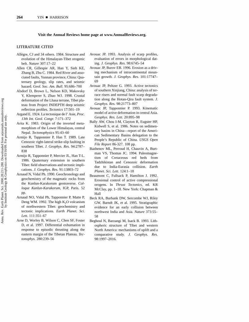
264 YIN n HARRISON
Visit the Annual Reviews home page at www.AnnualReviews.org.
LITERATURE CITED
Allegre, CJ and 34 others. 1984. Structure andevolution of the Himalayan-Tibet orogenicbelt. Nature 307:17–22
Allen CR, Gillespie AR, Han Y, Sieh KE,Zhang B, Zhu C. 1984. Red River and asso-ciated faults, Yunnan province, China: Qua-ternary geology, slip rates, and seismichazard. Geol. Soc. Am. Bull. 95:686–700
Alsdorf D, Brown L, Nelson KD, MakovskyY, Klemperer S, Zhao WJ. 1998. Crustaldeformation of the Lhasa terrane, Tibet pla-teau from Project INDEPTH deep seismicreflection profiles. Tectonics 17:501–19
Argand E. 1924. La tectonique de l’ Asie, Proc.13th Int. Geol. Congr. 7:171–372
Arita K. 1983. Origin of the inverted meta-morphism of the Lower Himalayas, centralNepal. Tectonophysics 95:43–60
Armijo R, Tapponnier P, Han T. 1989. LateCenozoic right-lateral strike-slip faulting insouthern Tibet. J. Geophys. Res. 94:2787–838
Armijo R, Tapponnier P, Mercier JL, Han T-L.1986. Quaternary extension in southernTibet: field observations and tectonic impli-cations. J. Geophys. Res. 91:13803–72
Arnaud N, Vidal Ph. 1990. Geochronology andgeochemistry of the magmatic rocks fromthe Kunlun-Karakorum geotraverse. Col-loque Kunlun-Karakorum, IGP, Paris. 52pp.
Arnaud NO, Vidal Ph, Tapponnier P, Matte P,Deng WM. 1992. The high K2O volcanismof northwestern Tibet: geochemistry andtectonic implications. Earth Planet. Sci.Lett. 111:351–67
Arne D, Worley B, Wilson C, Chen SF, FosterD, et al. 1997. Differential exhumation inresponse to episodic thrusting along theeastern margin of the Tibetan Plateau. Tec-tonophys. 280:239–56
Avouac JP. 1993. Analysis of scarp profiles,evaluation of errors in morphological dat-ing. J. Geophys. Res. 98:6745–54
Avouac JP, Burov EB. 1996. Erosion as a driv-ing mechanism of intracontinental moun-tain growth. J. Geophys. Res. 101:17747–69
Avouac JP, Peltzer G. 1993. Active tectonicsof southern Xinjiang, China: analysis of ter-race risers and normal fault scarp degrada-tion along the Hotan-Qira fault system. J.Geophys. Res. 98:21773–807
Avouac JP, Tapponnier P. 1993. Kinematicmodel of active deformation in central Asia.Geophys. Res. Lett. 20:895–98
Bally AW, Chou I-M, Clayton R, Eugster HP,Kidwell S, et al. 1986. Notes on sedimen-tary basins in China—report of the Ameri-can Sedimentary Basins delegation to thePeople’s Republic of China. USGS OpenFile Report 86-327. 108 pp.
Bazhenov ML, Perroud H, Chauvin A, Burt-man VS, Thomas JC. 1994. Paleomagne-tism of Cretaceous red beds fromTadzhikistan and Cenozoic deformationdue to India-Eurasia collision. EarthPlanet. Sci. Lett. 124:1–18
Beaumont C, Fullsack P, Hamilton J. 1992.Erosional control of active compressionalorogens. In Thrust Tectonics, ed. KRMcClay, pp. 1–18. New York: Chapman &Hall
Beck RA, Burbank DW, Sercombe WJ, RileyGW, Barndt JK, et al. 1995. Stratigraphicevidence for an early collision betweennorthwest India and Asia. Nature 373:55–58
Beghoul N, Barzangi M, Isack B. 1993. Lith-ospheric structure of Tibet and westernNorth America: mechanisms of uplift and acomparative study. J. Geophys. Res.98:1997–2016.
Ann
u. R
ev. E
arth
Pla
net.
Sci.
2000
.28:
211-
280.
Dow
nloa
ded
from
arj
ourn
als.
annu
alre
view
s.or
gby
Ins
titut
e G
eolo
gy &
Geo
phys
ics
on 0
3/16
/09.
For
per
sona
l use
onl
y.

HIMALAYAN-TIBETAN OROGEN 265
Bendick R, Bilham R, Yin G, Larson K, PeltzerG, Freymueller J. 1998. Slip rate of theAltyn Tagh Fault at 90 degrees east. Eos79:F207
Besse J, Courtillou V, Possi JP, Westphal M,Zhou YX. 1984. Paleomagnetic estimatesof crustal shortening in the Himalayanthrusts and Zangbo suture. Nature311:621–26
Bilham R, Larson K, Freymueller J, ProjectIdylhim members. 1997. GPS measure-ments of present-day convergence acrossthe Nepal Himalaya. Nature 386:61–64
Bird P. 1978. Initiation of intracontinental sub-duction in the Himalaya. J. Geophys. Res.83:4975–87
Blisniuk PM, Siwen S, Kuchel O, Ratsch-bacher L. 1998. Late Neogene extension inthe Shuang Hu graben, central Tibet. Eos79:794
Bouchez JL, Pecher A. 1981. The HimalayanMain Central Thrust pile and its quartz-richtectonites in central Nepal. Tectonophysics78:23–50
Bourjot L, Romanowiczs B. 1992. Crust andupper mantle tomography in Tibet usingsurface waves. Geophys. Res. Lett. 19:881–84
Briais A, Patriat P, Tapponnier P. 1993.Updated interpretation of magnetic anom-alies and seafloor spreading stages in theSouth China Sea: implications for the Ter-tiary tectonics of SE Asia. J. Geophys. Res.98:6299–328
Brookfield ME. 1993. The Himalayan passivemargin from Precambrian to Cretaceous.Sedimentary Geol. 84:1–35
Brown LD, Zhao W, Nelson KD, Hauck M,Alsdorf D, et al. 1996. Bright spots, struc-ture, and magmatism in Southern Tibetfrom INDEPTH seismic reflection profil-ing. Science 274:1688–91
Bruguier O, Lancelot JR, Malavieille J. 1997.U-Pb dating on single detrital zircon gran-ites from the Triassic Songpan-Ganzi flysch(Central China); provenance and tectoniccorrelations. Earth Planet. Sci. Lett.152:217–31
Burbank DW, Beck RA, Mulder T. 1996. TheHimalayan foreland basin. In The Tectonicsof Asia, ed. A Yin, TM Harrison, pp. 149–88. New York: Cambridge University Press
Burchfiel BC, Chen Z, Hodges KV, Liu Y,Royden LH, et al. 1992. The South TibetanDetachment System, Himalayan orogen:extension contemporaneous with and par-allel to shortening in a collisional mountainbelt. Geol. Soc. Am. Spec. Pap. 269:1–41
Burchfiel BC, Chen Z, Liu Y, Royden LH.1995. Tectonics of the Longmen Shan andadjacent regions, central China. Int. Geol.Rev. 37:661–735
Burchfiel BC, Chen Z, Royden LH, Liu Y,Deng C. 1991. Extensional development ofGabo valley, southern Tibet. Tectonophys-ics 194:187–93
Burchfiel BC, Deng Q, Molnar P, Royden LH,Wang Y, et al. 1989b. Intracrustal detach-ment with zones of continental deforma-tion. Geology 17:748–52
Burchfiel BC, Molnar P, Zhao Z, Linag K,Wang S, et al. 1989a. Geology of the UlughMuztagh area, northern Tibet. Earth Planet.Sci. Lett. 94:57–70
Burchfiel BC, Royden LH. 1991. Tectonics ofAsia 50 years after the death of EmileArgand. Ecologae Geol. Helv. 84:599–629
Burg JP, Brunel M, Gapais D, Chen GM, LiuGH. 1984. Deformation of leucogranites ofthe crystalline Main Central Sheet in south-ern Tibet (China). J. Struct. Geol. 6:535–42
Burg JP, Chen GM. 1984. Tectonics and struc-tural formation of southern Tibet, China.Nature 311:219–23
Burtman VS, Molnar P. 1993. Geological andgeophysical evidence for deep subductionof continental crust beneath the Pamir.Geol. Soc. Am. Special Paper 281:1–76
Chang C-F, Zheng S-L. 1973. Tectonic featuresof the Mount Jolmo Lungma region insouthern Tibet, China. Scientia GeologicaSinica. 1:1–12
Chen H, Dobson J, Heller F, Hao J. 1995.Paleomagnetic evidence for clockwise rota-tion of the Simao region since the Creta-ceous: a consequence of India-Asia
Ann
u. R
ev. E
arth
Pla
net.
Sci.
2000
.28:
211-
280.
Dow
nloa
ded
from
arj
ourn
als.
annu
alre
view
s.or
gby
Ins
titut
e G
eolo
gy &
Geo
phys
ics
on 0
3/16
/09.
For
per
sona
l use
onl
y.

266 YIN n HARRISON
collision. Earth Planet. Sci. Lett. 134:203–17
Chen SF, Wilson CJL, Deng QD, Zhao XL,Luo ZL. 1994. Active faulting and blockmovement associated with large earth-quakes in the Min Shan and LongmenMountains, northeastern Tibetan plateau. J.Geophys. Res. 99:24025–38
Chen W-P, Kao H. 1996. Seismotectonics ofAsia: some recent progress. In The TectonicEvolution of Asia, ed. A Yin, TM Harrison,pp. 37–52. Cambridge, UK: CambridgeUniv. Press
Chen W-P, Ozalaybey S. 1998. Correlationbetween seismic anisotropy and Bouguergravity anomalies in Tibet and its implica-tions for lithospheric structures. Geophys.J. Int. 135:93–101
Chen Y, Cogne J-P, Courtillot V. 1992. NewCretaceous paleomagnetic results from theTarim basin, northwestern China. EarthPlanet. Sci. Lett. 114:17–38
Chen Y, Cogne J-P, Courtillot V, Tapponnier P,Zhou XY. 1993. Cretaceous paleomagneticresults from western Tibet and tectonicimplications. J. Geophys. Res. 98:17981–18000
Cheng J, Xu G. 1986. Unpublished geologicmap of the Gaize region at a scale of1:1000,000 and the geologic report, XizangBureau of Geology and Mineral Resources,p. 369 (in Chinese)
Cheng J, Xu G. 1987a. Unpublished geologicmap of the Gedake region at a scale of1:1000,000 and the geologic report, XizangBureau of Geology and Mineral Resources,p. 363 (in Chinese)
Cheng J, Xu G. 1987b. Unpublished geologicmap of the Ritu region at a scale of1:1000,000 and the geologic report, XizangBureau of Geology and Mineral Resources,p. 598 (in Chinese)
Cheng YQ. 1994. Outline of Chinese RegionalGeology. Beijing: Geologic PublishingHouse. 517 pp. (in Chinese)
Chung, S-L, Lo C-C, Lee T-Y, Zhang Y, XieY, et al. 1998. Diachronous uplift of theTibetan plateau starting 40 Myr ago. Nature394:769–73
Cogan MJ, Nelson KD, Kidd WSF, Wu CD.1998. Shallow structure of the Yadong-Gulu rift, southern Tibet, from refractionanalysis of Project INDEPTH commonmidpoint data. Tectonics 17:46–61
Colchen M, Bassoullet JP, Mascle G. 1982. Lapaleogeographie des orogenes, l’examplede l’Himalaya. Mem. Geol. l’Univ. Dijon.7:453–71
Coleman ME. 1998. U-Pb constraints on Oli-gocene-Miocene deformation and anatexiswithin the central Himalaya, Marsyandivalley, Nepal. Am. J. Sci. 298:553–71
Coleman ME, Hodges KV. 1995. Evidence forTibetan Plateau uplift before 14 Myr agofrom a new minimum estimate for east-westextension. Nature 374:49–52
Coleman ME, Parrish RR. 1995. Constraintson Miocene high-temperature deformationand anatexis within the Greater Himalayafrom U-Pb geochronology. EOS 76:F708
Copeland P, Harrison TM, Hodges KV, Mareu-jol P, Le Fort P, Pecher A. 1991. An EarlyPliocene thermal perturbation of the MainCentral Thrust, Central Nepal: implicationsfor Himalayan tectonic. J. Geophys. Res.96:8475–500
Coulon C, Maluski H, Bollinger C, Wang S.1986. Mesozoic and Cenozoic volcanicrocks from central and southern Tibet: 39Ar/40Ar dating, petrological characteristics andgeodynamical significance. Earth Planet.Sci. Lett. 79:281–302
Coward MP and 9 others. 1988. Folding andimbrication of the Indian crust during Him-alayan collision. Phil. Trans. R. Soc. Lond.A326:89–116
Cowgill E, Yin A, Rumelhart P, Foster D, ChenZ, Wang XF. 1998. Magnitude and timingof Cenozoic Shortening in the W KunlunShan. EOS 79:F816
Cowgill E, Yin A, Rumelhart P, Wang XF,Zhang Q. 1997. Kinematics of the CentralAltyn Tagh Fault System, NW China. EOS78:173
Cowgill E, Yin A, Wang XF, Zhang Q. 1999.Late Cenozoic left-reverse slip movementalong the Northern Altyn Tagh Fault and itspossible development as the northern
Ann
u. R
ev. E
arth
Pla
net.
Sci.
2000
.28:
211-
280.
Dow
nloa
ded
from
arj
ourn
als.
annu
alre
view
s.or
gby
Ins
titut
e G
eolo
gy &
Geo
phys
ics
on 0
3/16
/09.
For
per
sona
l use
onl
y.

HIMALAYAN-TIBETAN OROGEN 267
boundary of a transpressional strike-slipduplex. Geology. In review
Crowell JC. 1962. Displacement along the SanAndreas fault, California. Geol. Soc. Am.Spec. Pap. 71:1–61
CSBS (Chinese State Bureau of Seismology).1992. The Altyn Tagh Active Fault System.Beijing: Seismology Publishing House. 319pp.
Curtis A, Trampert J, Snieder R, Dost B. 1998.Eurasian fundamental mode surface wavephase velocities and their relationship withtectonic structures. J. Geophys. Res.103:26919–47
Curtis A, Woodhouse JH. 1997. Crust andupper mantle shear velocity structurebeneath the Tibetan plateau and surround-ing regions from interevent surface wavephase velocity inversion. J. Geophys. Res.102:11789–813
D’Andrea J, Harrison TM, Grove M. 1999. Thethermal and physical state of the SouthTibetan middle crust between 20–8 Ma: U-Th-Pb and Nd isotopic evidence from theNyainqentanglha Massif. In 14th Hima-laya-Karakorum-Tibet Workshop, Abstractvolume, pp. 29–30. Germany: Kloster Ettal
Davis P, England P, Houseman G. 1997. Com-parison of shear wave splitting and finitestrain from the India-Asia collision zone. J.Geophys. Res. 102:27511–22
Davy Ph, Cobbold P. 1988. Indentation tecton-ics in nature and experiment, 1. Experi-ments scaled for gravity. Bull. Geol. Inst.,Univ. Uppsala 14:129–41
Delvaux D, Moeys R, Stapel G, Petit C, LeviK, et al. 1997. Paleostress reconstructionsand geodynamics of the Baikal region, Cen-tral Asia, Part 2. Cenozoic rifting. Tecton-ophysics 282:1–38
Deng W. 1989. Cenozoic volcanic rocks in thenorthern Ngari district of the Tibet—Dis-cussion on the concurrent subduction. ActaPetrol. Sin. 3:1–11 (in Chinese)
Deng W. 1996. The ophiolites of the geotrav-ersers from Yecheng to Shiquanhe. In Geo-logical Evolution of the Karakorum andKunlun Mountains, ed. P Yusheng, pp. 51–93. Beijing: Seismological Press
Deng W. 1998. Cenozoic Intraplate VolcanicRocks in the Northern Qinghai-XizangPlateau. Beijing: Geologic PublishingHouse. 180 pp. (in Chinese with Englishabstract)
Deng W, Yin J, Guo Z. 1996a. Basic-ultramaficand volcanic rocks in Chagbu-Shuanghuarea of northern Xizang (Tibet), China. Sci.China (Series D) 39:359–68
Deng W, Zheng X, Matsumoto Y. 1996b. Pet-rological characteristics and ages of Ceno-zoic volcanic rocks from the Hoh XilMountains, Qinghai. Acta Petrol. Miner.15:289–98 (in Chinese with Englishabstract)
Deverchere J, Houdry F, Diament M. 1991.Evidence for seismogenic upper mantle andlower crust in the Baikal rift. Geophys. Res.Lett. 18:1099–102
Dewey JF, Burke K. 1973. Tibetan, Variscanand Precambrian basement reactivation:products of continental collision. J. Geol.81:683–92
Dewey JF, Cande S, Pitman WC. 1989. Tec-tonic evolution of the India-Eurasia colli-sion zone. Ecol. Geol. Helv. 82:717–34
Dewey JF, Shackelton RM, Chang C, Sun Y.1988. The tectonic evolution of the TibetanPlateau. Phil. Trans. R. Soc. Lond.A327:379–413
Dickinson WR. 1996. Kinematics of transro-tational tectonism in the California Trans-verse Ranges and its contribution tocumulative slip along the San Andreastransform fault system. Geol. Soc. Am.Spec. Pap. 305:1–46
Dickinson WR, Wernicke BP. 1997. Reconcil-iation of San Andreas slip discrepancy by acombination of interior Basin-Range exten-sion and transrotation near the coast. Geol-ogy 25:663–65
Ding D, Wang D, Liu W, Sun S. 1996. TheWestern Kunlun Orogenic Belt and Basin.Beijing: Geologic Publishing House. 230pp.
Durr SB. 1996. Provenance of Xigaze fore-arcbasin clastic rocks (Cretaceous, southTibet). Geol. Soc. Am. Bull. 108:669–84
Ann
u. R
ev. E
arth
Pla
net.
Sci.
2000
.28:
211-
280.
Dow
nloa
ded
from
arj
ourn
als.
annu
alre
view
s.or
gby
Ins
titut
e G
eolo
gy &
Geo
phys
ics
on 0
3/16
/09.
For
per
sona
l use
onl
y.

268 YIN n HARRISON
Edwards MA, Harrison TM. 1997. When didthe roof collapse? Late Miocene N-S exten-sion in the High Himalaya revealed by Th-Pb monazite dating of the Khula Kangrigranite. Geology 25:543–46
Edwards MA, Kidd WSF, Li J, Yue Y, ClarkM. 1996. Multi stage development of thesouthern Tibet detachment system nearKhula Kangri. New data from Gonto La.Tectonophys. 260:1–20
England P, Houseman G. 1986. Finite straincalculations of continental deformation 2.Comparison with the India-Asia collisionzone. J. Geophys. Res. 91:3664–76
England P, Houseman G. 1989. Extension dur-ing continental convergence, with applica-tion to the Tibetan Plateau. J. Geophys. Res.94:17561–69
England P, Le Fort P, Molnar P, Pecher A.1992. Heat sources for Tertiary metamor-phism and anatexis in the Annapurna-Manaslu region, Central Nepal. J. Geophys.Res. 97:2107–28
England P, Molnar P. 1993. The interpretationof inverted metamorphic isograds usingsimple physical calculations. Tectonics12:145–57
England P, Molnar P. 1998. The field of crustalvelocity in Asia calculated from Quaternaryrates of slip on faults. Geophys. J. Int.130:551–82
Fang A, Li J, Hou Q, Zhou H, Wan S, Li H.1998. The first discovery of radiolarian fos-sils in Yixikegou flysch section of Kuda,west Kunlun, China. Sci. Geol. Sin. 33:300
Fletcher RC, Hallet B. 1983. Unstable exten-sion of the continental lithosphere: amechanical model for Basin-and-Rangestructure. J. Geophys. Res. 88:7457–66
Gaetani M, Garzanti E. 1991. Multicyclic his-tory of the northern India continental mar-gin (northwestern Himalaya). Am. Assoc.Pet. Geol. Bull. 75:1427–46
Gaetani M, Jadoul F, Erba E, Garzanti E. 1993.Jurassic and Cretaceous orogenic events inthe North Karakorum: age constraints fromsedimentary rocks. In Himalayan Tectonics,
ed. PJ Treloar, MP Searle, 74:39–52. Geol.Soc. Spec. Publ.
Gans P, Mahood GA, Schermer E. 1989.Synextensional magmatism in the Basinand Range Province; a case study from theeastern Great Basin. Geol. Soc. Am. Spec.Pap. 233:1–53
Gansser A. 1964. The Geology of the Hima-layas. New York: Wiley Interscience. 289pp.
Gao R, Cheng X, Wu G. 1999b. Lithosphericstructure and geodynamic model of theGolmud-Ejin transect in northern Tibet. InHimalaya and Tibet: Mountain Roots toMountain Tops, ed. A Macfarlane, RBSorkhabi, J Quade. Geol. Soc. Am. Spec.Pap. 328:9–17
Gao R, Li D, Lu D, Li Y, Huang D, et al. 1999a.Deep seismic reflection profiles across con-tact zone of Western Kunlun and Tarimalong the Xinjiang geotransect in NWChina. In 14th Himalaya-Karakorum-TibetWorkshop, Abstract volume, pp. 49–50.Germany: Kloster Ettal
Gao S, Davis PM, Liu H, Slack PD, Zorin YA,et al. 1994. Asymmetric upwarp of theasthenosphere beneath the Baikal rift zone,Siberia. J. Geophys. Res. 99:15319–30
Girardeau J, Marcous J, Allegre CJ, BassoulletJP, Tang Y, et al. 1984. Tectonic environ-ment and geodynamic significance of theNeo-Cimmerian Donqiao ophiolite, Ban-gong-Nujiang suture zone, Tibet. Nature307:27–31
Grasemann B, Vannay J-C. 1999. Flow con-trolled inverted metamorphism in shearzones. J. Struct. Geol. 21:743–50
Griot D-A, Mantagner J-P, Tapponnier P. 1998.Phase velocity structure from Rayleigh andLove waves in Tibet and its neighboringregions. J. Geophys. Res. 103:21215–32
Gu XX 1994. Geochemical characteristics ofthe Triassic Tethys-turbidites in northwest-ern Sichuan, China: implications for prov-enance and interpretation of the tectonicsetting. Geochim. Cosmochim. Acta58:4615–31
Guilbert J, Poupinet G, Jiang M. 1996. A study
Ann
u. R
ev. E
arth
Pla
net.
Sci.
2000
.28:
211-
280.
Dow
nloa
ded
from
arj
ourn
als.
annu
alre
view
s.or
gby
Ins
titut
e G
eolo
gy &
Geo
phys
ics
on 0
3/16
/09.
For
per
sona
l use
onl
y.

HIMALAYAN-TIBETAN OROGEN 269
of azimuthal P wave residuals and shearwave splitting across the Kunlun range(Northern Tibetan Plateau). Phys. EarthPlanet. Inter. 95:167–74
Hacker BR, Wang X, Eide EA, RatschbacherL. 1996. The Qinling-Dabie ultra-high pres-sure collisional orogen. In The TectonicEvolution of Asia, ed. A Yin, TM Harrison,pp. 345–70. Cambridge, UK: CambridgeUniv. Press
Harris N, Massey J. 1994. Decompression andanatexis of Himalayan metapelites. Tecton-ics 13:1537–46
Harris NBW, Xu R, Lewis CL, HawkeworthCJ, Zhang Y. 1988. Isotope geochemistryof the 1985 Tibet Geotraverse, Lhasa toGolmud. Phil Trans. R. Soc. Lond.A327:263–85
Harrison TM, Copeland P, Kidd WSF, LoveraOM. 1995b. Activation of the Nyainqen-tanghla shear zone: implications for upliftof the southern Tibetan Plateau. Tectonics14:658–76
Harrison TM, Copeland P, Kidd WSF, Yin A.1992. Raising Tibet. Science 255:1663–70
Harrison TM, Grove M, Lovera OM, CatlosEJ. 1998b. A model for the origin of Him-alayan anatexis and inverted metamor-phism. J. Geophys. Res. 103:27017–32
Harrison TM, Grove M, McKeegan KD, CoathCD, Lovera OM, Le Fort P. 1999a. Originand episodic emplacement of the Manasluinstrusive complex, Central Himalaya. J.Petrol. 40:3–19
Harrison TM, Leloup PH, Ryerson FJ, Tappon-nier P, Lacassin R, Chen W. 1996. Dia-chronous initiation of transtension alongthe Ailao Shan-Red River shear zone, Yun-nan and Vietnam. In The Tectonic Evolutionof Asia, ed. A Yin, TM Harrison, pp. 208–26. New York: Cambridge University Press
Harrison TM, Lovera OM, Grove M. 1997b.New insights into the origin of two con-trasting Himalayan granite belts. Geology25:899–902
Harrison TM, McKeegan KD, Le Fort P.1995a. Detection of inherited monazite inthe Manaslu leucogranite by 208Pb/232Th
ion microprobe dating: crystallization ageand tectonic significance. Earth Planet. Sci.Lett. 133:271–82
Harrison TM, Ryerson FJ, Le Fort P, Yin A,Lovera OM, Catlos EJ. 1997a. A LateMiocene-Pliocene origin for the CentralHimalayan inverted metamorphism. EarthPlanet. Sci. Lett. 146:E1–8
Harrison TM, Yin A, Grove M, Lovera OM,Ryerson FJ. 1999b. Displacement history ofthe Gangdese Thrust, Southeastern Tibet. J.Geophys. Res. In review
Harrison TM, Yin A, Ryerson FJ. 1998a. Oro-graphic evolution of the Himalaya andTibet. In Tectonic Boundary Conditions forClimate Reconstructions, ed. TJ Crowley,K Burke, pp. 39–72. New York: OxfordUniv. Press
Hauck ML, Nelson KD, Brown LD, Zhao WJ,Ross AR. 1998. Crustal structure of theHimalayan orogen at 90 degrees east lon-gitude from Project INDEPTH deep reflec-tion profiles. Tectonics 17:481–500
Heim A, Gansser A. 1939. Central HimalayaGeological Observations of Swiss Expedi-tion, pp. 1–246. Zurich: Gebruder Fretz
Hennig A. 1915. Zur petrographie und geolo-gie von sudwest Tibet. In Southern Tibet,Volume 5, ed. S Hedin. Stockholm: Nor-stedt. 220 pp.
Herquell G, Wittlinger G, Guilbert J. 1995.Anisotropy and crustal thickness of North-ern-Tibet. New constraints for tectonicmodeling. Geophys. Res. Lett. 22:1925–28
Herren E. 1987. Zanskar shear zone: North-east-southwest extension within the HigherHimalaya. Geology 15:409–13
Hirn A, and 10 others. 1995. Seismic aniso-tropy as an indicator of mantle flow beneaththe Himalayas and Tibet. Nature 375:571–74
Hodges KV, Bowring S, Davidek K, HawkinsD, Krol M. 1998. Evidence for rapid dis-placement on Himalayan normal faults andthe importance of tectonic denudation in theevolution of mountain ranges. Geology26:483–86
Hodges KV, Hames WE, Olszewski WJ,
Ann
u. R
ev. E
arth
Pla
net.
Sci.
2000
.28:
211-
280.
Dow
nloa
ded
from
arj
ourn
als.
annu
alre
view
s.or
gby
Ins
titut
e G
eolo
gy &
Geo
phys
ics
on 0
3/16
/09.
For
per
sona
l use
onl
y.

270 YIN n HARRISON
Burchfiel BC, Royden LH, Chen Z. 1994.Thermobarometric and 40Ar/39Ar geochron-ologic constraints on Eohimalayan meta-morphism in the Dinggy area, southernTibet. Contrib. Miner. Petrol. 117:151–63
Hodges KV, Parrish RR. Searle MP. 1996. Tec-tonic evolution of the central AnnapurnaRange, Nepalese Himalayas. Tectonics15:1264–91
Holt WE, Li M, Haines A. 1995. Earthquakestrain rates and instantaneous relativemotion within central and east Asia. Geo-phys. J. Int. 122:569–93
Honegger K, Dietrich V, Frank W, Gansser A,Thoeni M, Trommsdorff V. 1982. Magma-tism and metamorphism in the LadakhHimalaya (the Indus-Tsangpo suture zone).Earth Planet. Sci. Lett. 60:253–92
Hou L, Luo D, Fu D, Hu S, Li K. 1991. TriassicSedimentary-Tectonic Evolution in WesternSichuan and Eastern Xizang Region. Bei-jing: Geologic Publishing House. 220 pp.(in Chinese with English summary)
Houseman G, England P. 1996. A lithosphericthickening model for the Indo-Asian colli-sion. In The Tectonic Evolution of Asia, ed.A Yin, TM Harrison, pp. 3–17. New York:Cambridge Univ. Press
Hsu K and 15 others. 1995. Tectonic evolutionof the Tibetan Plateau: a working hypoth-esis based on the archipelago model of oro-genesis. Int. Geol. Rev. 37:473–508
Huang H, Huang Q, Ma Y. 1996. Geology ofQaidam Basin and its Petroleum Predic-tion. Beijing: Geological Publishing House.257 pp.
Huang K, Opdyke ND. 1993. Paleomagneticresults from Cretaceous and Jurassic rocksof south and southwest Yunnan: evidencefor large clockwise rotations in the Indo-china and Shan-Thai-Malay terranes. EarthPlanet. Sci. Lett. 117:507–24
Huang K, Opdyke ND, Li J, Peng X. 1992.Paleomagnetism of Cretaceous rocks fromeastern Qiangtang terrane. J. Geophys. Res.97:1789–99
Hubbard MS. 1996. Ductile shear as a cause ofinverted metamorphism: example from theNepal Himalaya. J. Geol. 104:493–99
Hubbard MS, Harrison TM. 1989. 40Ar/39Arage constraints on deformation and meta-morphism in the MCT Zone and TibetanSlab, eastern Nepal Himalaya. Tectonics8:865–80
Huerta AD, Royden LH, Hodges KV. 1996.The interdependence of deformational andthermal processes in mountain belts. Sci-ence 273:637–39
Hughes NC, Jell PA. 1999. Biostratigraphy andbiogeography of Himalayan Cambrian tri-lobites. In Himalaya and Tibet: MountainRoots to Mountain Tops, ed. A Macfarlane,RB Sorkhabi. Geol. Soc. Am. Spec. Pap.328:109–16
Jacobson CE, Oyarzabal FR, Haxel GB. 1996.Subduction and exhumation of the Pelona-Orocopia-Rand schists, southern Califor-nia. Geology 24:547–50
Jaeger J-J, Courtillot V, Tapponnier P. 1989.Paleontological view of the ages of the Dec-can traps, the Cretaceous/Tertiary boundaryand the India-Asia collision. Geology17:316–19
Jia C. 1997. Tectonic characteristics and petro-leum: Tarim Basin, China. Beijing: Petro-leum Industry Press. 295 pp.
Jia C, Yao H, Wi G, Li L. 1991. Plate tectonicevolution and characteristics of major tec-tonic units of the Tarim basin. In The TarimBasin, ed. X Tong, D Liang, pp. 207–25.Urumuqi: Xinjiang Scientific PublishingHouse (in Chinese)
Jiang C, Yang J, Feng B, Zhu Z, Zhao M, etal. 1992. Opening-Closing Tectonics ofKunlun Mountains. Beijing: Geologic Pub-lishing House. 224 pp. (in Chinese withEnglish abstract)
Jin Y, McNutt MK, Zhu YS. 1996. Mappingthe descent of Indian and Eurasian platesbeneath the Tibetan Plateau from gravityanomalies. J. Geophys. Res. 101:11275–90
Johnson NM, Opdyke ND, Johnson GD, Lind-say EH, Tahirkheli RAK. 1982. Magneticpolarity stratigraphy and ages of Siwalik
Ann
u. R
ev. E
arth
Pla
net.
Sci.
2000
.28:
211-
280.
Dow
nloa
ded
from
arj
ourn
als.
annu
alre
view
s.or
gby
Ins
titut
e G
eolo
gy &
Geo
phys
ics
on 0
3/16
/09.
For
per
sona
l use
onl
y.

HIMALAYAN-TIBETAN OROGEN 271
Group rocks of the Potwar Plateau, Paki-stan. Paleogeog. Paleoclimat. Paleoecol.37:17–42
Johnson NM, Stix J, Tauxe L, Cerveny PF,Tahirkheli RAK. 1985. Paleomagneticchronology, fluvial processes, and tectonicimplications of the Siwalik deposits nearChinji Village, Pakistan J. Geol. 93:27–40
Kapp P, Murphy MA, Yin A, Ding L. 1999b.Cenozoic shortening along the Banggong-Nujiang suture zone, central Tibet. In 14thHimalaya-Karakorum-Tibet Workshop,Abstract volume, pp. 81–83. Germany:Kloster Ettal
Kapp P, Yin A, Manning CE, Murphy M, Har-rison TM, et al. 1998. Post-mid-Cretaceousshortening along the Banggong-Nujiangsuture and in west-central Qiangtang, Tibet.EOS 79:794
Kapp P, Yin A, Manning CE, Murphy M, Har-rison TM, et al. 1999a. Blueschist-bearingmetamorphic core complexes in the Qiang-tang block reveal deep crustal structure ofnorthern Tibet. Geology. In press
Kapp P, Yin A, Murphy M, Harrison TH, Ryer-son FJ. 1997. Discovery of a major blueschist bearing detachment fault system inthe Shuang Hu region of the Qiangtangblock, northern Tibet. Geol. Soc. Am. Abstr.Prog. 29:144
Khan MA, Jan Q, Weaver BL. 1993. Evolutionof the lower crust in Kohistan, N. Pakistan:temporal arc magmatism through early,mature and intra-arc rift stages. In Hima-layan Tectonics, ed. PJ Treloar, MP Searle,74:123–38. Geol. Soc. Spec. Publ.
Kidd WSF, Molnar P. 1988. Quaternary andactive faulting observed on the 1985 Aca-demia Sinica-Royal Society Geotraverse ofTibet. Phil. Trans. R. Soc. Lond. A327:337–63
Kincaid C, Silver P. 1996. The role of viscousdissipation in the orogenic process. EarthPlanet. Sci. Lett. 142:271–88
Kind R, Ni J, Zhao W, Wu J, Yuan X, et al.1996. Evidence from earthquake data for apartially molten crustal layer in southernTibet. Nature 274:1692–1694
King RW, Shen F, Burchfiel BC, Chen Z, Li Y,et al. 1997. Geodetic measurement ofcrustal motion in southwest China. Geology25:1279–82
Klootwijk CT, Conaghan PJ, Nazirullah R, deJong KA. 1994. Further palaeomagneticdata from Chitral (Eastern Hindukush): evi-dence for an early India-Asia contact. Tec-tonophys. 237:1–25
Klootwijk CT, Gee FS, Peirce JW, Smith GM,McFadden PL. 1992. An early India con-tact: paleomagnetic constraints fromNinetyeast Ridge, ODP Leg 121. Geology20:395–98
Kong X, Bird P. 1996. Neotectonics of Asia:thin-shell, finite-element models withfaults. In The Tectonics of Asia, ed. A Yin,TM Harrison, pp. 18–35. New York: Cam-bridge Univ. Press
Kong X, Yin A, Harrison TM. 1997. Evaluat-ing the role of pre-existing weakness andtopographic distributions in the Indo-Asiancollision by use of a thin-shell numericalmodel. Geology 25:527–30
Kosarev G, Kind R, Sobolev SV, Yuan X,Hanka W, Oreshin S. 1998. Seismic evi-dence for a detached Indian lithosphericmantle beneath Tibet. Science 283:1306–9
Lacassin R, Replumaz A, Leloup PH. 1998.Hairpin river loops and slip-sense inversionon southeast Asian strike-slip faults. Geol-ogy 26:703–6
Larson K, Burgmann R, Bilham R, Frey-mueller JT. 1999. Kinematics of the India-Eurasia collision zone from GPSmeasurements. J. Geophys. Res. 104:1077–93
Lave J, Avouac JP, Laccassin R, Tapponnier P,Montagner JP. 1996. Seismic anisotropybeneath Tibet: evidence for eastward extru-sion of the Tibetan lithosphere? EarthPlanet. Sci. Lett. 140:83–96
Leeder MR, Smith AB, Yin J. 1988. Sedimen-tology, palaeoecology and palaeoenviron-mental evolution of the 1985 Lhasa toGolmud Geotraverse. Phil. Trans. R. Soc.Lond. A327:107–43
Ann
u. R
ev. E
arth
Pla
net.
Sci.
2000
.28:
211-
280.
Dow
nloa
ded
from
arj
ourn
als.
annu
alre
view
s.or
gby
Ins
titut
e G
eolo
gy &
Geo
phys
ics
on 0
3/16
/09.
For
per
sona
l use
onl
y.

272 YIN n HARRISON
Le Fort P. 1975. Himalayas, the collided range.Present knowledge of the continental arc.Am. J. Sci. 275A:1–44
Le Fort P. 1986. Metamorphism and magma-tism during the Himalayan collision. InCollision Tectonics, ed. MP Coward, ACRies. Geol. Soc. Spec. Publ. 19:159–72
Le Fort P. 1989. The Himalayan orogenic seg-ment. In Tectonic Evolution of the TethyanRegion, ed. AMC Sengor, pp. 289–386.Berlin: Kluwer Acad.
Le Fort P. 1996. Evolution of the Himalaya. InThe Tectonics of Asia, ed. A Yin, TM Har-rison, pp. 95–106. New York: CambridgeUniv. Press
Le Fort P, Debon F, Sonet J. 1983. The lowerPalaeozoic ‘‘Lesser Himalaya’’ graniticbelt: emphasis on the Simchar pluton ofCentral Nepal. In Granites of Himalayas,Karakorum and Hindu Kush, ed. FAShams, pp. 235–53. Lahore: Punjab Univ.
Leloup PH, Harrison TM, Ryerson FJ, ChenW, Li Q, et al. 1993. Structural, petrologicaland thermal evolution of a Tertiary ductilestrike-slip shear zone, Diancang Shan (Yun-nan, PRC). J. Geophys. Res. 98:6715–43
Leloup PH, Lacassin R, Tapponnier R, ZhongD, Lui X, et al. 1995. Kinematics of Terti-ary left-lateral shearing at the lithospheric-scale in the Ailao Shan-Red River shearzone (Yunnan, China). Tectonophysics251:3–84
Le Pichon X, Fournier M, Jolivet L. 1992. Kin-ematics, topography, shortening, and extru-sion in the India-Eurasia collision.Tectonics 11:1085–98
Li C. 1987. The Longmu Co-Shuanghu-Lancangjiang Suture as the northern bound-ary of the Gandwanaland in theCarboniferous and Permian. Bull. Chang-cun Coll. Geol. Sci. 17:155–66 (in Chinese)
Li C, Liren C, Ke H, Zengrong Y, Yurong H.1995. Study on the Paleo-Tethys SutureZone of Lungmu Co-Shuanghu, Tibet. Bei-jing: Geological Publishing House. 131 pp.(in Chinese with English abstract)
Li C, Zheng A. 1993. Paleozoic stratigraphy inthe Qiangtang region of Tibet: relations of
the Gandwana and Yangtze continents andocean closure near the end of the Carbon-iferous. Int. Geol. Rev. 35:797–804
Li CY, Liu Y, Zhu BC, Feng YM, Wu HC.1978. Structural evolution of Qinling andQilian Shan. In Scientific Papers in Geologyand International Exchange, pp. 174–97.Beijing: Geologic Publishing House (inChinese)
Li CY, Wang Q, Liu X, Tang Y. 1982. Explan-atory Notes to the Tectonic Map of Asia.Beijing: Cartographic Publishing House
Li D, Liang D, Jia C, Wang G, Wu Q, He D.1996. Hydrocarbon accumulations in theTarim basin, China. Am. Assoc. Pet. Geol.Bull. 80:1587–603
Liou JG, Zhang RY, Wang X, Eide EA, ErnstWG, Maruyama S. 1996. Metamorphismand tectonics of high-pressure and ultra-high pressure belts in the Dabie-Suluregion, China. In The Tectonic Evolution ofAsia, ed. A Yin, TM Harrison, pp. 300–44.New York: Cambridge Univ. Press
Liu FT, Wa H, Liu J-H, Hu G, Li Q, Qu K.1990. 3-D velocity images beneath the Chi-nese continent and adjacent regions. Geo-phys. J. Int. 101:379–94
Liu ZQ. 1988. Geologic Map of the Qinghai-Xizang Plateau and its NeighboringRegions (scale at 1:1,500,000). ChengduInstitute of Geology and MineralResources. Beijing: Geologic PublishingHouse
Luyendyk BP. 1989. Crustal rotation and faultslip in the continental transform zone insouthern California. In PaleomagneticRotations and Continental Deformation,ed. C Kissel, C Laj, pp. 229–46. Dordrecht,Holland: Kluwer Acad.
Luyendyk BP, Kamerling MJ, Terres RR, Hor-nafius JS. 1985. Simple shear of southernCalifornia during Neogene time suggestedby paleomagnetic declinations. J. Geophys.Res. 90:12454–66
Lyon-Caen H, Molnar P. 1984. Gravity anom-alies and the structure of western Tibet andthe southern Tarim Basin. Geophys. Res.Lett. 11:1251–54
Ann
u. R
ev. E
arth
Pla
net.
Sci.
2000
.28:
211-
280.
Dow
nloa
ded
from
arj
ourn
als.
annu
alre
view
s.or
gby
Ins
titut
e G
eolo
gy &
Geo
phys
ics
on 0
3/16
/09.
For
per
sona
l use
onl
y.

HIMALAYAN-TIBETAN OROGEN 273
Lyon-Caen H, Molnar P. 1985. Gravity anom-alies, flexure of the Indian plate, and thestructure, support and evolution of the Him-alaya and the Ganga Basin. Tectonics4:513–38
Makovsky Y, Klemperer SL. 1999. Measuringthe seismic properties of Tibetan brightspots. Evidence for free aqueous fluids inthe Tibetan middle crust. J. Geophys. Res.104:10795–825
Makovsky Y, Klemperer SL, Huang L, Lu D,Project INDEPTH Team. 1996. Structuralelements of the southern Tethyan Himalayacrust from wide-angle seismic data. Tecton-ics 15:997–1005
Manning CE, Kapp P, Yin A, Murphy M, Har-rison TM, et al. 1998. Metamorphism andexhumation of Mesozoic melange in north-central Tibet. EOS 79:815
Masek JG, Isacks BL, Gubbels TL, FieldingEJ. 1994. Erosion and tectonics at the mar-gins of continental plateaus. J. Geophys.Res. 99:13941–56
Mattauer M. 1986. Intracontinental subduc-tion, crustal stacking wedge and crust-mantle decollement. In Collision Tectonics,ed. MP Coward, AC Ries. Geol. Soc. Lond.Spec. Publ. 19:37–50
Matte P, Mattauer M, Olivet JM, Griot DA.1997. Continental subduction beneath Tibetand the Himalayan orogen: a review. TerraNova 9:264–70
Matte P, Tapponnier P, Arnaud N, Bourjot L,Avouac JP, et al. 1996. Tectonics of WesternTibet, between the Tarim and the Indus.Earth Planet. Sci. Lett. 142:311–30
McCaffrey R, Nabelek J. 1998. Role of obliqueconvergence in the active deformation ofthe Himalayas and southern Tibet plateau.Geology 26:691–94
McNamara DE, Owens TJ, Silver PG, Wu FT.1994. Shear wave anisotropy beneath theTibetan Plateau. J. Geophys. Res. 99:13655–65
McNamara DE, Owens TJ, Walter WR. 1995.Observations of the regional phase propa-gation in the Tibetan plateau. J. Geophys.Res. 100:22215–29
Meert JG, Van der Voo R. 1997. The assemblyof Gondwana 800–550 Ma. J. Geodyn.23:223–35
Mercier J-L, Armijo R, Tapponnier P, Carey-Gailhardis E, Han TL. 1987. Change fromTertiary compression to Quaternary exten-sion in southern Tibet during the India-Asiacollision. Tectonics 6:275–304
Meyer B, Tapponnier P, Bourjot L, Metivier F,Gaudemer Y, et al. 1998. Crustal thickeningin Gansu-Qinghai, lithospheric mantle sub-duction, and oblique, strike-slip controlledgrowth of the Tibet plateau. Geophys. J. Int.135:1–47
Meyer B, Tapponnier P, Gaudemer Y, PeltzerG, Guo S, Chen Z. 1996. Rates of left-lateral movement along the easternmostsegment of the Altyn Tagh fault, east of96oE (China). Geophys. J. Int. 124:29–44
Molnar P. 1984. Structure and tectonics of theHimalaya: constraints and implications ofgeophysical data. Annu. Rev. Earth Planet.Sci. 12:489–518
Molnar P, Burchfiel BC, Zhao Z, Lian K, WangS, Huang M. 1987. Geologic evolution ofnorthern Tibet: results of an expedition toUlugh Muztagh. Science 23:299–305
Molnar P, Chen W-P, Padovani E. 1983. Cal-culated temperatures in overthrust terrainsand possible combinations of heat sourcesresponsible for the Tertiary granites in theGreater Himalaya. J. Geophys. Res.88:6415–29
Molnar P, England P, Martinod J. 1993. Mantledynamics, the uplift of the Tibetan Plateau,and the Indian monsoon. Rev. Geophys.31:357–96
Molnar P, Lyon-Caen H. 1989. Fault planesolutions of earthquakes and active tecton-ics of the northern and eastern parts of theTibetan Plateau. Geophys. J. Int. 99:123–53
Molnar P, Tapponnier P. 1975. Cenozoic tec-tonics of Asia; effects of a continental col-lision. Science 189:419–26
Molnar P, Tapponnier P. 1978. Active tectonicsof Tibet. J. Geophys. Res. 85:5361–75
Montel J-M. 1993. A model for monazite/melt
Ann
u. R
ev. E
arth
Pla
net.
Sci.
2000
.28:
211-
280.
Dow
nloa
ded
from
arj
ourn
als.
annu
alre
view
s.or
gby
Ins
titut
e G
eolo
gy &
Geo
phys
ics
on 0
3/16
/09.
For
per
sona
l use
onl
y.
274 YIN n HARRISON
equilibrium and application to the genera-tion of granitic magmas. Chem. Geol.119:127–46
Murphy JB, Nance RD. 1991. Supercontinentmodel for the contrasting character of LateProterozoic orogenic belts. Geology19:469–72
Murphy MA, Harrison TM. 1999. The rela-tionship between leucogranites and theSouth Tibetan detachment system, Rong-buk Valley, southern Tibet. Geology27:831–34
Murphy MA, Yin A, Harrison TM, Durr SB,Chen Z, et al. 1997. Significant crustalshortening in south-central Tibet prior tothe Indo-Asian collision. Geology 25:719–22
Murphy MA, Yin A, Kapp P, Harrison TM, DinL, Guo J. 1999. Southward propagation ofthe Karakoram fault system into southwestTibet: timing and magnitude of slip. Geol-ogy (in review)
Najman Y, Clift P, Johnson MRW, RobersonAHF. 1993. Early stages of foreland basinevolution in the Lesser Himalaya, N. India.In Himalayan Tectonics, ed. PJ Treloar, MPSearle. Geol. Soc. Spec. Publ. 74:541–58
Najman YMR, Enkin RJ, Johnson MRW, Rob-ertson AHF, Baker J. 1994. Paleomagneticdating of the earliest continental Himalayanforedeep sediments: implications for Him-alayan evolution. Earth Planet. Sci. Lett.128:713–18
Nakata T. 1989. Active faults of the Himalayain India and Nepal. In Tectonics of the West-ern Himalaya, ed. LL Malinconico, RJ Lil-lie. Geol. Soc. Am. Spec. Pap. 232:243–64
Nelson KD and 27 others. 1996. Partially mol-ten middle crust beneath Southern Tibet:synthesis of Project INDEPTH results. Sci-ence 274:1684–96
Ni J, Barazangi M. 1984. Seismotectonics ofthe Himalayan collision zone: geometry ofthe underthrusting Indian plate beneath theHimalaya. J. Geophys. Res. 89:1147–63
Ni J, York J. 1978. Late Cenozoic tectonics ofthe Tibetan plateau. J. Geophys. Res.83:5377–84
Nie S, Yin A, Rowley D, Jin Y. 1994. Exhu-mation of the Dabie shan ultra-high pres-sure rocks and accumulation of theSongpan-Ganzi flysch sequence, centralChina. Geology 22:999–1002
Noble SR, Searle MP. 1995. Age of crustalmelting and leucogranite formation from U-Pb zircon and monazite dating in the west-ern Himalaya, Zanskar, India. Geology23:1135–38
Owens TJ, Zandt G. 1997. Implications ofcrustal property variations for models ofTibetan plateau evolution. Nature 387:37–43
Pan Y. 1990. Tectonic features and evolutionof the western Kunlun Mountain region.Sci. Geol. Sin. 3:224–32 (in Chinese withEnglish abstract)
Pan Y. 1993. Unroofing history and structuralevolution of the southern Lhasa terrane,Tibetan Plateau: implications for the con-tinental collision between India and Asia.Ph.D. dissertation. State Univ. New York,Albany
Pan Y. 1996. Regional geologic evolution andconclusion. In Geologic Evolution of theKarakorum and Kunlun Mountains, ed. PYunsheng, pp. 263–88. Beijing: Seismolog-ical Press
Parrish RR, Hodges KV. 1993. Miocene (22 51 Ma) metamorphism and two stage thrust-ing in the Greater Himalayan sequence,Annapurna Sanctuary, Nepal. Geol. Soc.Am. Abstr. Progr. 25:A174
Parrish RR, Hodges KV. 1996. Isotopic con-straints on the age and provenance of theLesser and Greater Himalayan sequences,Nepalese Himalaya. Bull. Geol. Soc. Am.108:904–11
Patriat P, Achache J. 1984. India-Eurasia col-lision chronology has implications forcrustal shortening and driving mechanismof plates. Nature 311:615–21
Pecher A. 1989. Metamorphism in the centralHimalaya. J. Metamorph. Petrol. 7:31–41
Peltzer G, Saucier F. 1996. Present day kine-matics of Asia derived from geologic faultrates. J. Geophys. Res. 101:27943–56
Ann
u. R
ev. E
arth
Pla
net.
Sci.
2000
.28:
211-
280.
Dow
nloa
ded
from
arj
ourn
als.
annu
alre
view
s.or
gby
Ins
titut
e G
eolo
gy &
Geo
phys
ics
on 0
3/16
/09.
For
per
sona
l use
onl
y.

HIMALAYAN-TIBETAN OROGEN 275
Peltzer G, Tapponnier P. 1988. Formation andevolution of strike-slip faults, rifts, andbasins during the India-Asia collision: anexperimental approach. J. Geophys. Res.93:15085–117
Peltzer G, Tapponnier P, Amijio R. 1989. Mag-nitude of late Quaternary left-lateral dis-placement along the north edge of Tibet.Science 246:1285–89
Pierce JA, Deng W. 1988. The ophiolites of theTibetan geotraverse, Lhasa-Golmud (1985)and Lhasa to Kathmandu (1986). Phil.Trans. R. Soc. Lond. A327:215–38
Pierce JA, Mei H. 1988. Volcanic rocks of the1985 Tibet Geotraverse Lhasa to Golmud.Phil. Trans. R. Soc. Lond. A327:203–13
Pinet C, Jaupart C. 1987. A thermal model forthe distribution in space and time of theHimalayan granites. Earth Planet. Sci. Lett.84:87–99
Powell CM, Conaghan PG. 1973. Plate tecton-ics and the Himalayas. Earth Planet. Sci.Lett. 20:1–12
Powell RE. 1993. Balanced palinspastic recon-struction of pre-Late Cenozoic paleogeol-ogy, southern Californa: geologic andkinematic constraints on evolution of theSan Andreas fault system. In The SanAndreas Fault System: Displacement, Pal-inspastic Reconstruction, and GeologicEvolution, ed. RE Powell, RJ Weldon II, JCMatti. Geol. Soc. Am. Mem. 178:1–106
Price RA. 1981. The Cordilleran forelandthrust and fold belt in the southern Cana-dian Rocky Mountains. In Thrust andNappe Tectonics, ed. MP Coward, KRMcClay. Geol. Soc. Lond. Spec. Publ.9:427–48
Qinghai BGMR (Qinghai Bureau of Geologyand Mineral Resources). 1991. RegionalGeology of Qinghai Province. Beijing:Geological Publishing House. 662 pp.
Quade J, Cater JLM, Ojha TP, Adam J, Harri-son TM. 1995. Late Miocene environmen-tal change in Nepal and the northern Indiansubcontinent: stable isotope evidence frompaleosols. Geol. Soc. Am. Bull. 107:1381–97
Quidelleur X, Grove M, Lovera OM, Harrison
TM, Yin A, Ryerson FJ. 1997. The thermalevolution and slip history of the RenbuZedong Thrust, southeastern Tibet. J. Geo-phys. Res. 102:2659–79
Ramstein G, Fluteau FF, Besse J, JoussaumeS. 1997. Effect of orogeny, plate motion,and land-sea distribution on Eurasian cli-mate change over the past 30 million years.Nature 286:788–95
Rao R, Xu J, Chen Y, Zou D. 1987. The Tri-assic System of the Qianghai-Xizang Pla-teau. Beijing: Geological PublishingHouse. 239 pp.
Ratschbacher L, Frisch W, Chen C, Pan G.1996. Cenozoic deformation, rotation, andstress patterns in eastern Tibet and westernSichuan, China. In The Tectonic Evolutionof Asia, ed. A Yin, TM Harrison, pp. 227–49. New York: Cambridge Univ. Press
Ratschbacher L, Frisch W, Lui G, Chen C.1994. Distributed deformation in southernand western Tibet during and after theIndia-Asia collision. J. Geophys. Res.99:19817–945
Rowley DB. 1996. Age of collision betweenIndia and Asia: a review of the stratigraphicdata. Earth Planet. Sci. Lett. 145:1–13
Rowley DB. 1998. Minimum age of initiationof collision between India and Asia northof Everest based on the subsidence historyof the Zhepure Mountain section. J. Geol.106:229–35
Richter FM, Lovera OM, Harrison TM, Cope-land P. 1991. Tibetan tectonics from a sin-gle feldspar sample: an application of the40Ar/39Ar method. Earth Planet. Sci. Lett.105:266–76
Rothery DA, Drury SA. 1984. The neotecton-ics of the Tibetan Plateau. Tectonics 3:19–26
Royden L. 1996. Coupling and decoupling ofcrust and mantle in convergent orogens:implications for strain partitioning in thecrust. J. Geophys. Res. 101:17679–705
Royden LH. 1993. The steady state thermalstructure of eroding orogenic belts andaccretionary prisms. J. Geophys. Res.98:4487–507
Ann
u. R
ev. E
arth
Pla
net.
Sci.
2000
.28:
211-
280.
Dow
nloa
ded
from
arj
ourn
als.
annu
alre
view
s.or
gby
Ins
titut
e G
eolo
gy &
Geo
phys
ics
on 0
3/16
/09.
For
per
sona
l use
onl
y.

276 YIN n HARRISON
Royden LH, Burchfiel BC, King RW, Wang E,Chen Z, et al. 1997. Surface deformationand lower crustal flow in eastern Tibet. Sci-ence 276:788–90
Ruddiman WF, Kutzbach JE. 1989. Forcing ofLate Cenozoic northern hemisphere climateby plateau uplift in southern Asia andthe American west. J. Geophys. Res. 94:18409–27
Rumelhart P, Yin A, Butler R, Cowgill E,Zhang Q, Wang X. 1999. Cenozoic vertical-axis rotation of southern Tarim: constraintson the tectonic evolution of the Altyn Taghfault system. Geology 27:819–22
Rumelhart PA. 1998. Cenozoic basin evolutionof southern Tarim, northwestern China:implications for the uplift history of theTibetan Plateau. Ph.D thesis. Univ. Calif.,Los Angeles
Rupple C, Kogan MG, McNutt MK. 1993.Implications of new gravity data for Baikalrift zone structure. Geophys. Res. Lett.20:1635–38
Ryerson FJ, Peltzer G, Tapponnier P, FinkelRC, Meriaux A, Caffee MW. 1999. Slip-rates on the Karakax valley segment of theAltyn Tagh fault: constraints from surfacedating. In 14th Himalaya-Karakorum-TibetWorkshop, Abstract volume, pp. 185–86.Germany: Kloster Ettal
Sandvol E, Ni J, Kind R, Zhao W. 1997. Seis-mic anistropy beneath the southern Hima-layas-Tibet collision zone. J. Geophys. Res.102:17813–23
Scharer U, Xu RH, Allegre CJ. 1984. U-Pbgeochronology of the Gangdese (Transhi-malaya) plutonism in the Lhasa-Xigazeregion, Tibet. Earth Planet. Sci. Lett.69:311–20
Scharer U, Xu RH, Allegre CJ. 1986. U-(Th)-Pb systematics and ages of Himalayan leu-cogranites, South Tibet. Earth Planet. Sci.Lett. 77:35–48
Schelling D. 1992. The tectonostratigraphy andstructure of the eastern Nepal Himalaya.Tectonics 11925–43
Schelling D, Arita K. 1991. Thrust tectonics,crustal shortening, and the structure of the
far-eastern Nepal, Himalaya. Tectonics10:851–62
Searle MP. 1991. Geology and Tectonics of theKarakoram Mountains. New York: Wiley.358 pp.
Searle MP. 1996. Cooling history, erosion,exhumation, and kinematics of the Hima-laya-Karakoram-Tibet orogenic belt. In TheTectonic Evolution of Asia, ed. A Yin, TMHarrison, pp. 110–37. New York: Cam-bridge Univ. Press
Searle MP, Cooper DJW, Rex AJ. 1988. Col-lision tectonics of the Ladakh-ZanskarHimalaya. Phil. Trans. R. Soc. Lond.A326:117–50
Searle MP, Parrish RR, Hodges KV, HurfordA, Ayres MW, Whitehouse MJ. 1997.Shisha Pangma leucogranite, south TibetanHimalaya: field relations, geochemistry,age, origin, and emplacement. J. Geol.105:295–317
Searle MP, Weinberg RF, Dunlap WJ. 1998.Transpressional tectonics along the Kara-koram fault zone, northern Ladakh: con-straints on Tibetan extrusion. InContinental Transpressional and Transten-sional Tectonics, ed. RE Holdsworth, RAStrachan, JF Dewey. Geol. Soc. Lond. Spec.Publ. 135:307–26
Sengor AMC. 1984. The Cimmeride orogenicsystem and the tectonics of Eurasia. Geol.Soc. Am. Spec. Pap. 195:1–82
Sengor AMC. 1990. Plate tectonics and oro-genic research after 25 years: a Tethyan per-spective. Earth Sci. Rev. 27:1–201
Sengor AMC, Natal’in BA. 1996. Paleotecton-ics of Asia: fragments of a synthesis. In TheTectonics of Asia, ed. A Yin, TM Harrison,pp. 486–640. New York: Cambridge Univ.Press
Sengor AMC, Okurogullari AH. 1991. Therole of accretionary wedge in the growth ofcontinents: Asiatic examples from Argandto plate tectonics. Ecol. Geol. Helv. 84:535–97
Shen Z, Zhao C, Yin A, Li C, Jackson DD, etal. 1999. Contemporary crustal deformationin east Asia constrained by Global Posi-
Ann
u. R
ev. E
arth
Pla
net.
Sci.
2000
.28:
211-
280.
Dow
nloa
ded
from
arj
ourn
als.
annu
alre
view
s.or
gby
Ins
titut
e G
eolo
gy &
Geo
phys
ics
on 0
3/16
/09.
For
per
sona
l use
onl
y.

HIMALAYAN-TIBETAN OROGEN 277
tioning Measurements. J. Geophys. Res. Inpress
Shi X, Yin J, Jia C. 1996. Mesozoic to Ceno-zoic sequence stratigraphy and sea-levelchanges in the Northern Himalayas, south-ern Tibet, China. Newsl. Stratigr. 33:15–61
Silver PG. 1996. Seismic anisotropy beneaththe continents: probing the depths of geol-ogy. Annu. Rev. Earth Planet. Sci. 24:385–432
Smith AB, Xu J. 1988. Palaeontology of the1985 Tibet Geotraverse, Lhasa to Golmud.Phil Trans. R. Soc. Lond. A327:53–105
Song T, Wang X. 1993. Structural styles andstratigraphic patterns of syndepositionalfaults in a contractional setting: examplefrom Quaidam basin, northwestern China.Am. Assoc. Pet. Geol. Bull. 77:102–17
Srivastava P, Mitra G. 1994. Thrust geometriesand deep structure of the outer and lesserHimalaya, Kumaon and Garwal (India):implications for evolution of the Himalayanfold-and-thrust belt. Tectonics 13:89–109
Strecker MR, Frisch W, Hamburger MW,Ratschbacher L, Semiletkin S, et al. 1995.Quaternary deformation in the easternPamirs, Tadzhikistan and Kyrgyzstan, Tec-tonics 14:1061–79
Sullivan MA, Windley BF, Saunders AD,Haynes JR, Rex DC. 1993. A palaeogeo-graphic reconstruction of the Dir Group:evidence for magmatic arc migration withinKohistan, N. Pakistan. In Himalayan Tec-tonics, ed. PJ Treloar, MP Searle. Geol. Soc.Spec. Publ. 74:139–60
Sylvester AG. 1988. Strike-slip fault. Geol.Soc. Am. Bull. 100:1666–703
Tapponnier P, Lacassin R, Leloup PH, ScharerU, Zhong D, et al. 1990. The Ailao Shan/Red River metamorphic belt: Tertiary left-lateral shear between Indochina and SouthChina. Nature 343:431–37
Tapponnier P, Mercier JL, Armijo R, Han T,Zhao TJ. 1981. Field evidence for activenormal faulting in Tibet. Nature 294:410–14
Tapponnier P, Molnar PJ. 1976. Slip-line fieldtheory and large-scale continental tectonics.Nature 264:319–24
Tapponnier P, Molnar PJ. 1977. Active faultingand tectonics of China. J. Geophys. Res.82:2905–30
Tapponnier P, Molnar P. 1979. Active faultingand Cenozoic tectonics of Tien Shan, Mon-golia, and Baikal regions. J. Geophys. Res.84:3425–59
Tapponnier P, Peltzer G, Armijo R. 1986. Onthe mechanics of the collision betweenIndia and Asia. In Collision Tectonics, ed.MP Coward, AC Ries. Geol. Soc. Lond.Spec. Publ. 19:115–57
Tapponnier P, Peltzer G, Le Dain AY, ArmijoR, Cobbold P. 1982. Propagating extrusiontectonics in Asia: new insights from simpleexperiments with plasticine. Geology10:611–16
Tonarini S, Villa I, Oberli F, Meier M, SpencerDA, et al. 1993. Eocene age of eclogitemetamorphism in Pakistan Himalaya:implications for India-Eurasia collision.Terra Nova 5:13–20
Turner S, Arnaud N, Liu J, Rogers N, Haw-kesworth CJ, et al. 1996. Post-collision,shoeshonitic volcanism on the Tibetan pla-teau: implications for convective thinningof the lithosphere and the source of oceanisland basalts. J. Petrol. 37:45–71
Turner S, Hawkesworth CJ, Liu J, Rogers N,Kelley S, van Calsteren P. 1993. Timing ofTibetan uplift constrained by analysis ofvolcanic rocks. Nature 364:50–53
Vance D, Harris N. 1999. The timing of pro-grade metamorphism in the Zanskar Him-alaya. Geology 27:395–98
van der Beek P. 1997. Flank uplift and topog-raphy at the central Baikal Rift (SE Sibe-ria): a test of kinematic models forcontinental extension. Tectonics 16:122–36
Van der Woerd J, Ryerson FJ, Tapponnier P,Gaudemer Y, Finkel R, et al. 1998. Holo-cene left-slip rate determined by cosmo-genic surface dating on the Xidatansegment of the Kunlun fault (Qinghai,China). Geology 26:695–98
Wang C, Hu C, Wu R. 1987. Discovery andgeologic significance of the Casang-Caburift in northern Xizang. Bull. Chengdu Coll.Geol. Sci. 14:33–46
Ann
u. R
ev. E
arth
Pla
net.
Sci.
2000
.28:
211-
280.
Dow
nloa
ded
from
arj
ourn
als.
annu
alre
view
s.or
gby
Ins
titut
e G
eolo
gy &
Geo
phys
ics
on 0
3/16
/09.
For
per
sona
l use
onl
y.

278 YIN n HARRISON
Wang E. 1997. Displacement and timing alongthe northern strand of the Altyn Tagh faultzone, northern Tibet. Earth Planet. Sci.Lett. 150:55–64
Wang E, Burchfiel BC. 1997. Interpretation ofCenozoic tectonics in the right-lateralaccommodation zone between the AilaoShan shear zone and the eastern Himalayansyntaxis. Int. Geol. Rev. 39:191–219
Wang E, Burchfiel BC, Royden LH, Chen Z,Chen J, et al. 1998. Late Cenozoic Xiang-shuihe-Xiaojiang, Red River, and Dali faultsystems of southwestern Sichuan and cen-tral Yunnan, China. Geol. Soc. Am. Spec.Pap. 327:1–108
Wang N, Yang J, Xia Z, Me D, Li Y, Pan M.1996. Cenozoic Sedimentation and TectonicGeomorphology of the Shanxi Graben. Bei-jing: Chinese Science Publishing House.400 pp.
Wang S, Li Z, Qiangba X. 1983. Unpublishedgeologic map (1:1,000,000) and geologicreport of the Xigaze area, Xizang Bureau ofGeology and Mineral Resources, 568 pp.
Wang T. 1996. Characteristics of sedimentaryrocks and their environmental evolution. InGeological Evolution of the Karakorumand Kunlun Mountains, ed. P Yusheng, pp.22–50. Beijing: Seismological Press
Willems H, Zhou Z, Zhang B, Grafe K-U.1996. Stratigraphy of the Upper Cretaceousand Lower Tertiary strata in the TethyanHimalayas of Tibet (Tingri area, China).Geol. Rundsch. 85:723–54
Willett SD, Beaumont C. 1994. Subduction ofAsian lithospheric mantle beneath Tibetinferred from models of continental colli-sion. Nature 369:642–45
Wittlinger G, Tapponnier P, Poupinet G, JiangM, Shi D, et al. 1998. Tomographic evi-dence for localized lithospheric shear alongthe Altyn Tagh fault. Science 282:74–76
Worley B, Powell R, Wilson CJL. 1997. Cren-ulation cleavage formation: evolving dif-fusion, deformation and equilibrationmechanisms with increasing metamorphicgrade. J. Struct. Geol. 19:1121–35
Worley BA, Wilson CJL. 1996. Deformationpartitioning and foliation reactivation dur-ing transpressional orogenesis, an examplefrom the Central Longmen Shan, China. J.Struct. Geol. 18:395–411
Wu C, Nelson KD, Wortman G, Samson S, YueY, et al. 1998. Yadong cross structure andSouth Tibetan detachment in the east cen-tral Himalaya (898–908E). Tectonics 17:28–45
Xia L, Xia Z, Xu X. 1996. Origin of the Oce-anic Island Arc System in the Northern Qil-ian Shan. Beijing: Geological PublishingHouse. 153 pp.
Xiao X, Chen G, Zhu Z. 1978. Geological andtectonic significance of paleo-ophiolitezone of the Qilian Mountains. Acta Geol.Sin. 52:281–95
Xie G, Liu C, Zheng T. 1992. Geochemicalcharacteristics of Cenozoic volcanic rocksalong the rim of the Tibetan plateau—evi-dence for ancient enriched mantle. In Meso-zoic and Cenozoic Volcanic Rocks andTheir Geochemical Characteristics, ed. LiuRouxing, pp. 100–27. Beijing: Seismolog-ical Press
Xinjiang BGMR (Xinjiang Bureau of Geologyand Mineral Resources). 1989. RegionalGeology of the Xinjiang Uygur AutonomousRegion. Beijing: Geological PublishingHouse
Xizang BGMR (Xizang Bureau of Geologyand Mineral Resources). 1992. RegionalGeology of the Xizang Autonomous Region.Beijing: Geological Publishing House
Xu R, Zhang Y, Xie Y, Vidal Ph, Arnaud N, etal. 1996. Isotopic geochemistry of plutonicrocks. In Geological Evolution of the Kara-korum and Kunlun Mountains, ed. PYusheng, pp. 137–86. Beijing: Seismolog-ical Press
Xu RH. 1990. Age and geochemistry of gran-ites and metamorphic rocks in south-centralXizang (Tibet). In Igneous and Metamor-phic Rocks of the Tibetan Plateau, ed. Chi-nese Academy of Geological Sciences, pp.287–302. Beijing: Science Press
Xu RH, Scharer U, Allegre CJ. 1985. Mag-matism and metamorphism in the Lhasa
Ann
u. R
ev. E
arth
Pla
net.
Sci.
2000
.28:
211-
280.
Dow
nloa
ded
from
arj
ourn
als.
annu
alre
view
s.or
gby
Ins
titut
e G
eolo
gy &
Geo
phys
ics
on 0
3/16
/09.
For
per
sona
l use
onl
y.

HIMALAYAN-TIBETAN OROGEN 279
block (Tibet): a geochronological study. J.Geol. 93:41–57
Xu Z, Mei J, Yang J, Zhao G, Cui J, et al. 1998.Mantle diapir and inward intracontinentalsubduction: a discussion on the mechanismof uplift of the Qinghai-Tibet Plateau. InHimalaya and Tibet: Mountain Roots toMountain Tops, ed. A Macfarlane, RBSorkhabi, J Quade. Geol. Soc. Am. Spec.Pap. 328:19–31
Yin A. 1999. Mode of Cenozoic east-westextension in Tibet suggests a common ori-gin of rifts in Asia during the Indo-Asiancollision. J. Geophys. Res. In review
Yin A, Harrison TM, Murphy MA, Grove M,Nie S, et al. 1999a. Tertiary deformationhistory of southeastern and southwesternTibet during the Indo-Asian collision. Geol.Soc. Am. Bull. 111:1644–64
Yin A, Harrison TM, Ryerson FJ, Chen W,Kidd WSF, Copeland P. 1994. Tertiarystructural evolution of the Gangdese thrustsystem, southeastern Tibet. J. Geophys.Res. 99:18175–201
Yin A, Kapp P, Manning CE, Harrison TM,Din L, Deng X. 1998a. Extensive exposureof Mesozoic melange in Qiangtang and itsrole in the Cenozoic development of theTibetan plateau. Eos 79:816
Yin A, Kapp PA, Murphy MA, Manning CE,Harrison TM, et al. 1999c. Evidence forsignificant Late Cenozoic E-W extension inNorth Tibet. Geology 17:787–90
Yin A, Kapp PA, Murphy M, Manning C, Har-rison TM. 1998b. Evidence for large scaleunderthrusting (.250 km) of Lhasabeneath Qiangtang during the Indo-Asiancollision: implications for the deep-crustalstructures in Tibet and uplift mechanisms.Geol. Soc. Am. Abstr. Progr. 30:A353
Yin A, Kong X. 1997. Spacing of N-S rifts inTibet implies lithospheric extension. Eos78:F173
Yin A, Murphy MA, Harrison TM, Ryerson FJ,Chen Z, et al. 1996. Miocene evolution ofthe Kailas thrust and Gurla Mandhatadetachment fault, western Tibet: implica-tions for the displacement history of the
Karakorum fault. In 11th Himalaya-Karakorum-Tibet Workshop, Abstract vol-ume, Flagstaff, Arizona, pp. 173–74
Yin A, Nie S. 1993. An indentation model forNorth and South China collision and thedevelopment of the Tanlu and Honam faultsystems, eastern Asia. Tectonics 12:801–13
Yin A, Nie S. 1996. A Phanerozoic palinspasticreconstruction of China and its neighboringregions. In The Tectonics of Asia, ed. A Yin,TM Harrison, pp. 442–85. New York: Cam-bridge Univ. Press
Yin A, Wang X, Harrison TM, Cowgill E,Rumelhart P, et al. 1999b. Preliminaryresults from a collaborative geologic inves-tigation of the Altyn Tagh Fault, NorthTibet. In 14th Himalaya-Karakorum-TibetWorkshop, Abstract volume, pp. 185–86.Germany: Kloster Ettal
Yin J. 1997. Stratigraphic Geology of Gand-wanan Facies of Qinghai-Xiang (Tibet)Plateau and Adjacent Areas. Beijing: Geo-logic Publishing House. 206 pp.
Yin J, Bian Q. 1992. Geologic Map of theKarakorum-Western Kunlun and AdjacentRegions (1:2M). Beijing: Science Press
Yin J, Xu J, Liu C, Li H. 1988. The Tibetanplateau: regional stratigraphic context andprevious work. Phil. Trans. R. Soc. Lond.A327:5–52
Yu Z, Zheng A-Z. 1979. Unpublished geologicmap of the Lhasa region at a scale of1:1,000,000 and geologic report, XizangBureau of Geology and Mineral Resources,p. 284 (in Chinese)
Yuan X, Ni J, Kind R, Mechie, J, Sandvol E.1997. Lithospheric and upper mantle struc-ture of southern Tibet from a seismologicalpassive source experiment. J. Geophys.Res. 102:27491–500
Zhang G, Li J. 1998. Triassic flysch trace fos-sils and their geological significance fromeast Karakorum mountains, China. Sci.Geol. Sin. 33:257–66
Zhang J, Xu Z, Xu H, Li H. 1998. Frameworkof North Qilian Caledonian subduction-
Ann
u. R
ev. E
arth
Pla
net.
Sci.
2000
.28:
211-
280.
Dow
nloa
ded
from
arj
ourn
als.
annu
alre
view
s.or
gby
Ins
titut
e G
eolo
gy &
Geo
phys
ics
on 0
3/16
/09.
For
per
sona
l use
onl
y.

280 YIN n HARRISON
accretionary wedge and its deformationdynamics. Sci. Geol. Sin. 33:290–99
Zhang M, Hu C, Wu R. 1985. Geochemicalcharacteristics and tectonic setting of theXiangqiong-Casang mafic volcanic belt. InGeologic Research on the Qinghai-XizangPlateau Publication no. 9, pp. 57–68. Bei-jing: Geological Publishing House
Zhang Y, Zheng J. 1994. Geologic Overview inKokshili, Qinghai and Adjacent Areas. Bei-jing: Seismological Publishing House. 177pp.
Zhang YQ, Mercier JL, Vergely P. 1998.Extension in the graben system around theOrdos (China), and its contribution to theextrusion tectonics of south China withrespect to Gobi-Mongolia. Tectonophys.285:41–75
Zhao W, Morgan WJ. 1987. Injection of Indiancrust into Tibetan lower crust: a two-dimen-
sional finite element model study. Tectonics6:489–504
Zhao W, Nelson KD, Project INDEPTH. 1993.Deep seismic reflection evidence for con-tinental underthrusting beneath southernTibet. Nature 366:557–59
Zhong D. 1998. Paleotethyan Orogenic Beltsin Yunan and Western Sichuan. Beijing:Science Publishing House. 230 pp.
Zhou D, Graham SA. 1993. Songpan-GanziTriassic flysch complex as a remnant-ocean-basin along diachronous collisionorogen, central China. Geol. Soc. Am. Abstr.with Programs 25:A118
Zhou D, Graham SA. 1996. The Songpan-Ganzi complex of the western Qinling Shanas a Triassic remnant ocean basin. In TheTectonic Evolution of Asia, ed. A Yin, TMHarrison. pp. 281–99. Cambridge, UK:Cambridge Univ. Press
Ann
u. R
ev. E
arth
Pla
net.
Sci.
2000
.28:
211-
280.
Dow
nloa
ded
from
arj
ourn
als.
annu
alre
view
s.or
gby
Ins
titut
e G
eolo
gy &
Geo
phys
ics
on 0
3/16
/09.
For
per
sona
l use
onl
y.

Annual Review of Earth and Planetary Science Volume 28, 2000
CONTENTSPalynology after Y2K--Understanding the Source Area of Pollen in Sediments, M. B. Davis 1
Dinosaur Reproduction and Parenting, John R. Horner19
Evolution and Structure of the Lachlan Fold Belt (Orogen) of Eastern Australia, David A. Foster, David R. Gray 47
Remote Sensing of Active Volcanoes, Peter Francis, David Rothery 81Dynamics of Volcanic Systems in Iceland: Example of Tectonism and Volcanism at Juxtaposed Hot Spot and Mid-Ocean Ridge Systems, Agust Gudmundsson 107
Understanding Oblique Impacts from Experiments, Observations, and Modeling, E. Pierazzo, H. J. Melosh 141
Synthetic Aperture Radar Interferometry to Measure Earth''s Surface Topography and Its Deformation, Roland Bürgmann, Paul A. Rosen, Eric J. Fielding 169Geologic Evolution of the Himalayan-Tibetan Orogen, An Yin, T. Mark Harrison 211
MARS 2000, Arden L. Albee 281
Vredefort, Sudbury, Chicxulub: Three of a Kind, Richard Grieve, Ann Therriault 305Climate Reconstruction from Subsurface Temperatures, Henry N. Pollack, Shaopeng Huang 339
Asteroid Fragmentation and Evolution of Asteroids, Eileen V. Ryan 367Seismic Imaging of Mantle Plumes, Henri-Claude Nataf 391
New Perspectives on Orbitally Forced Stratigraphy, Linda A. Hinnov 419
Clathrate Hydrates, Bruce A. Buffett 477Heterogeneity of the Lowermost Mantle, Edward J. Garnero 509Spreading Volcanoes, Andrea Borgia, Paul T. Delaney, Roger P. Denlinger 539Scaling, Universality, and Geomorphology, Peter Sheridan Dodds, Daniel H. Rothman 571Chemical Weathering, Atmospheric CO2, and Climate, Lee R. Kump, Susan L. Brantley, Michael A. Arthur 611Self-Ordering and Complexity in Epizonal Mineral Deposits, Richard W. Henley, Byron R. Berger 669
Ann
u. R
ev. E
arth
Pla
net.
Sci.
2000
.28:
211-
280.
Dow
nloa
ded
from
arj
ourn
als.
annu
alre
view
s.or
gby
Ins
titut
e G
eolo
gy &
Geo
phys
ics
on 0
3/16
/09.
For
per
sona
l use
onl
y.