anaconda edition - the clark fork watershed education program · anaconda remediation and voices...
TRANSCRIPT

Volume 7, Issue 1 July, 2019A Publication of the Clark Fork Watershed Education Programcfwep.org
A view of Mount Haggin and Anaconda from Stucky Ridge. Photo by Kayla Lappin.
Page 5 Page 12
Anaconda Edition
Anaconda Remediation and Restoration Update
Anaconda Edition
Mount Haggin Waste Management Area
Anaconda Remediation and Restoration Update
Voices from the Watershed: Anaconda Students
Page 10Page 5 Page 10
Mount Haggin Waste Management Area
Voices from the Watershed: Anaconda Students
Page 12
Located in southwest Montana in Deer Lodge Valley at the foot of the Anaconda Range (locally known as the Pintler’s), Anaconda is a small town, spanning just 737 square miles. Presently, she is home to about 9,100 residents, a large town by Montana standards. Anaconda is rich in history, culture and personality, and is surrounded by beautiful natural areas like Mount Haggin Wildlife Management Area and the Anaconda-Pintler Wilderness area.
The town of Anaconda was founded by Marcus Daly in 1883, making her 136 years old this year. Marcus Daly, infamously known as one of
the “copper kings,” founded the town for his employees to work at the Washoe Smelter, refining the copper ore extracted from Daly’s Anaconda Mine in Butte. In the mid-1890’s, Daly unsuccessfully campaigned to have Anaconda designated as Montana’s state capital, losing out to William A. Clark, another copper king, who pushed to keep Helena as the state capital.
The origin of the name of Anaconda is credited to Michael Hickey who is thought to have influenced Daly to name the town, Anaconda. Hickey, a young veteran Union
soldier of the Civil War, was inspired by Horace Greeley, who said, “go west, young man.” And westward Hickey headed, bringing with him another Greeley quote concerning the Civil War. Greely stated that Union armies would “encircle Lee’s forces and crush them like a giant anaconda.” The image of this awesome snake stayed with Hickey as he traveled west to Butte. When he was buying mine claims in 1875, Hickey named one of his mines, the Anaconda Mine.
Continued on Back (Pg. 16)
Ask Dr. A: What is the Origin of the Town of AnacondaDr. Arlene Alvarado
This is part two in our watershed series. For the Headwaters Edition see cfwep.org/montana-stewardThis is part two in our watershed series. For the Headwaters Edition see cfwep.org/montana-steward

Page 3Page 2 The Montana Steward: Anaconda Edition The Montana Steward: Anaconda Edition
CFWEP Program UpdatesChris Doyle
The programs and outreach events that CFWEP delivers are geared towards learning more about science, our local environments, and the restoration that is taking place, all to ensure a better future for generations to come. It is our responsibility to teach and provide opportunities for everyone to learn about watershed science and the importance of stewardship in our own backyards. In 2018-2019, our programs reached students in the Clark Fork Watershed communities and throughout the state.
In the 2018-2019 school year, we reached 8,000 students ranging from kindergarten to high school, and had over 16,000 contact hours with them. Over 40 teachers throughout the state either had CFWEP in their classroom or attended a training or tour. Some of the programs that were offered in were the Restoration Education Program, Bringing Research into the Classroom, Trout in the Classroom, Stormwater, Beaver Mimicry, Treat Street, Teacher Workshops, and Tours.
This year, we finished the last round of classroom visits for the Bringing Research into the Classroom (BRIC) program. This project was a four-year teacher professional development and student outreach program funded by a National Institute of Health (NIH-NIGMS) Science Education Partnership Award (SEPA). CFWEP partnered with Dr. Marisa Pedulla from the Montana Tech Biology Department to lead students though a bacteriophage research project in their classroom.
Throughout the four years of this program, the CFWEP staff and Dr. Pedulla reached over 8,000 students with over 20,000 hours of contact. The project staff traveled well over 45,000 miles within the state boarders to cover all the teachers
and students in this program. Hopefully, this work can continue in the future to help teachers and students with more in-depth research opportunities.
CFWEP recently completed the spring semester Trout in the Classroom (TIC) program and the Restoration Education Program (REP). Through the TIC program, students learn about westlope cutthroat trout and their riaparian habitat. This program mostly serves local elementary and Blackfoot River area schools. This year we reached over 400 students wtih TIC. The spring REP program visited over 700 students in Butte Central Elementary School, Phillipsburg, Deer Lodge, Anaconda, and Ramsay. REP engages students in the History of Mining, mining damages, and the restoration of Silver Bow Creek and the Upper Clark Fork River.
In March, CFWEP hosted the Montana Environmental Education Association (MEEA) conference at Fairmont Hot Springs, bringing together approximately 75 environmental educators from around Montana. At the
This publication’s content is the result of collaborative efforts between many passionate and dedicated individuals. Each member of the CFWEP staff team contributed time and effort to bring this publication to life. We’d like to extend special thanks to Charlie Coleman, Greg Mullan, and Pedro Marques.
CFWEP Staff
Rayleynn Brandl Director
Dr. Arlene Alvarado Education Coordinator
Tammy Gordon Budget Analyst
Chris Doyle Program Coordinator
Dalit Guscio Missoula Program Manager
Kayla Lappin Communication & Events Coordinator
conference, participants learned about topics around the theme, Community Engagement through Citizen Science and Creating Stewards.
CFWEP recently finished up the largest Cleanup Blacktail Stream Day (CUBS) in its history. We had 391 students out with us from a number of local schools in Butte, as well as many volunteers from the community. In the three hours of the cleanup, the students collected over 300 bags of trash from the streams and floodplain areas. We hope this annual event keeps growing into the future.
Volunteers are needed in the upcoming months for various programs including the annual kids Fly Fishing and Conservation Camp in August, and the Restoration Education Program in September. If you would like to join us as a volunteer or learn more about how you can support CFWEP and the work that is being done, please contact CFWEP at (406) 496-4790 or email [email protected]. Know where you live, make it better, and enjoy the areas these communities have to offer.
The rivalry between Butte and Anaconda runs deep. Perhaps our rivalry has been rooted in family and is good-natured overall. Everyone knows that the rule of thumb is, ‘I can pick on my cousin, but once someone else tries, we are all in this together.’ This rule is pretty much how things have been through our storied history together. Butte and Anaconda are rivals until another city or town
wants to take one of us on, then we are one.
Throughout our history, Butte shipped its ore to be refined and smelted in Anaconda beginning in the late 1880’s until 1980 when Atlantic Richfield Company closed the Washoe Reduction Works. Many old-time miners reflect on the fact that much of the Berkeley Pit now resides as slag in Anaconda. Butte is left with a hole in the ground and Anaconda is left with a pile of waste. Sister cities indeed, both in history and in our present-day challenges.
Within the Clark Fork Superfund Complex, the Anaconda sites are some of the most challenging to address. The sheer volume of wastes that have been left in place within the city boundaries, the proximity of the wastes to homes and water supplies, and the extensive acreages that were damaged in the uplands by nearly a century of smelter smoke ensure long nights for the engineers who are designing solutions. As agencies and local scientists work to develop the best plan for Anaconda, so too have her citizens rallied to find effective solutions for clean-up and economic development.
In this issue, we highlight the hopes that the citizens of Anaconda have for their community. We illuminate some of the beautiful history of the city that Marcus Daly wanted to name Copperopolis. We attempt to educate and inform all of us about the complex issues that Anaconda faces, the solutions proposed, and current projects underway for economic development. Butte and Anaconda have much to learn from one another and can certainly help each other create a positive future.
The Director’s LetterSister City of Anaconda
Rayelynn Brandl
Publication Editors
Arlene Alvarado
Rayelynn Brandl
Kayla Lappin
Design & Layout
Kayla Lappin
Published July, 2019
Anaconda, Montana, USA
These folks are working tirelessly on our Superfund sites across the Upper Clark Fork River Basin. Bringing diverse skills and talents, they are all contributing their time and effort to a healthier environment. We want to give them recognition and say THANK YOU for all of your hard work in helping to make our communities better.
Businesses Working on Anaconda Superfund
AECOM
Agency for Toxic Substances and Disease Registry (ATSDR)
Anaconda – Deer Lodge County
Arcadis
Arrowhead Foundation
Ashe Analytics
Atlantic Richfield Company (ARCO)
Big Sky Reclamation
Booth Consulting
Butte-Silver Bow Residential Metals Abatement Program (RMAP)
Canyon Creek Nursery
CDM Smith
Citizens Environmental Committee of Butte (CTEC)
Colbert Electric
Copper Environmental
Davis Graham & Stubs (DG & S)
Energy Lab
Environmental Protection Agency (EPA)
Fairweather IT
Formation Environmental
GoBird Montana
Granite Mountain Electric
Hunter Brothers Construction
Industrial Automation Consulting, Inc.
Intermountain Construction Services (ICS)
Jordan Contracting
Kel’s Sprinklers
Over
45,000
Miles Traveled for the BRIC Project
Land Design, Inc. (LDI)
Land Restoration Specialists (LRS)
Marcom Lab
Montana Bureau of Mines and Geology (MBMG)
Montana Department of Environmental Quality (DEQ)
Montana Department of Public Health and Human Services (MDPHHS)
Montana Fish, Wildlife, & Parks (FWP)
Montana Technological University (Montana Tech)
Natural Resource Damage Program (NRDP)
O’Keefe Drilling Company
Pace Analytical
Pathfinder Utility Locating
Pioneer Technical Services, Inc.
Poore, Roth & Robinson, P.C.
RWH Engineering
Schroeder Contracting Inc.
TeleTech
TREC, Inc.
UTRS
Wasley Excavating
Water and Environmental Technologies (WET)
Weltner Communications
Anaconda’s Local Development and Superfund is a Winning CombinationKayla Lappin & Rayelynn Brandl
The people of the Clark Fork Watershed have long endured the fallout from one of the most significant copper mining operations in the United States, and Anaconda, Montana is no exception to this economic downturn. Yet, despite losing much of its population (at its peak was 12,500, and is now roughly 9,100), Anaconda remains an economic stronghold in southwest Montana. CFWEP met with former Anaconda Local Development Corporation (ALDC) Director, Jim Davison and current Director, Adam Vauthier, to discuss some of the reasons why Anaconda continues to perform well in economic development, despite its Superfund status and ongoing population recovery.
One thing that stood out to us in terms of economic success is the fact that ALDC and Anaconda’s Arrowhead Foundation work so closely together. The Arrowhead Foundation is the bridge between Superfund and the Anaconda community. They receive a Technical Assistance Grant (TAG) from the Environmental Protection Agency (EPA) to interpret information for the public, but one of their other focuses is on economic redevelopment and site reuse. Most notably the Arrowhead Foundation played a major role in establishing the Old Works Golf Course and the Anaconda Trail system.
According to Davison, it was the synergy between ALDC and the Arrowhead Foundation that brought these endeavors to light. “Superfund in Anaconda is so closely
related to economic development that we never really saw Superfund as separate from local development. When Arrowhead was formed, we worked closely with ALDC,” Jim recalled to us. This gave Anaconda a unique advantage. They have been able to effectively communicate and leverage Superfund using a business-minded focus. Davison was instrumental in developing the partnership between ALDC and the Arrowhead Foundation.
One of the major successes of economic development in Deer Lodge county was NorthWestern Energy’s Dave Gates Generating Station, which has increased tax revenue for Deer Lodge County significantly. Another victory for Deer Lodge County is the development of new facilities by AWARE and CCCS. These endeavors are unique in the realm of Superfund because they go beyond protecting human health and the environment, and dive into the economic territory of the losses surrounding Superfund.
ALDC’s current director, Adam Vauthier, will continue the legacy of synergy between Superfund and economic development. “Anaconda is on the cusp of great things, and I am hoping to steward the relationship between Superfund and the economy to see Anaconda closer to its peak in population and vibrancy as part of Montana’s economy.”
A view of the Old Works Golf Course and Anaconda from Stucky Ridge. Photo by Kayla Lappin.
Page 5Page 4 The Montana Steward: Anaconda Edition The Montana Steward: Anaconda Edition
Superfund acronyms are confusing. Often the persons involved in Superfund sound as if they are speaking their own language. We provide this lexicon as a brief orientation to the language of Superfund. We hope readers will find this list useful.
ACMAnaconda Copper Mining Company
ARWWS OUAnaconda Regional Water, Waste & Soils Operable Unit
The largest of the operable units in Anaconda at nearly 20,000 acres, it has been broken into 15 sub-areas or RDUs:
• Stucky Ridge• Lost Creek• Smelter Hill Uplands• Anaconda Ponds, Active• Railroads/Blue Lagoon• South Opportunity • North Opportunity• Opportunity Ponds• Fluvial Tailings• Warm Springs Creek• Cashman Concentrate• Slag• Old Works Groundwater• Smelter Hill Facility• Mt. Haggin Uplands
CERCLAComprehensive Environmental Response, Compensation and Liability Act of 1980, also known as Superfund or Superfund Law
COCContaminants of Concern
Broadly defined, contaminants of concern are chemical elements or compounds that are known to cause a threat to human health, or animal and plant life. In the Clark Fork Watershed, the contaminants of concern are arsenic, cadmium, copper, lead, mercury and zinc. Arsenic, cadmium, and lead are particularly concerning for human health, while copper and zinc can affect aquatic and terrestrial life.
CDConsent Decree is the legal term for a settlement agreed to by court order. In a Consent Decree, the dispute between the parties is agreed to without admission of guilt. In the case of Superfund, the companies or owners are referred to a “potentially” responsible parties rather than responsible parties as there is no admission of wrong-doing.
In Superfund, the Consent Decree negotiations are the final step for settlement. The CD defines the methods, extent of clean-up and future monitoring. The CD is informed by the remedial investigation, feasibility studies, the Record of Decision, and any ROD modifications completed prior to the CD negotiations.
DEQ or MTDEQMontana State Department of Environmental Quality
EPA (USA)United States Environmental Protection Agency
ERAExpedited Response Action
ERAs are meant to address initial cleanup measures without waiting to complete the Remedial Investigation and Feasibility Study.
ESDExplanation of Significant Differences
This legal term applies to the process that the EPA and PRP’s utilize if there are significant changes to the Record of Decision. The ESD gives rationale for the changes that were made. The ESD is sent to the Federal Department of Justice for review. The information and data included in the ESD are reviewed by the federal judge. The public is allowed to send written comment letters to the judge regarding the changes proposed in the ESD, however, the ESD is not subject to the usual public comment period.
FSFeasibility Study
Once the remedial investigation is complete, and the nature and extent of contamination are understood, the EPA evaluates various remedy options for technical, environmental, and cost effectiveness concerns. The feasibility study guides the conceptual design and construction process. Typically, both the EPA and the responsible party will conduct feasibility studies. These studies are completed prior to the Record of Decision negotiations.
NPLNational Priorities List
The National Priorities List is often interchanged with the term “Superfund Sites.” The list refers to identified sites that have known releases of hazardous substances, pollutants, and/or contaminants throughout the United States. As of June 3, 2019, there were 1,344 active sites on the NPL, 45 proposed new sites and 396 deleted sites.
NRDP or NRD Natural Resource Damage Program (NRDP)
This program was established in 1990 to prepare for the state’s lawsuit against Atlantic Richfield Company (ARCO). NRDP is operated by the Montana Department of Justice and includes a team of litigation specialists, scientists, and engineers who manage all superfund lawsuits that take place in the State of Montana. In the Clark Fork Watershed, NRDP currently manages the settlement dollars and restoration activities through its two local councils, the Upper Clark Fork River Basin Advisory Council and the Butte Natural Resource Damage Council.
OU
Operable Unit
Large acreage superfund sites, such as our site, are often broken into smaller management sections, or operable units. The operable units typically are divided by geographic constraints and/or the nature of the remedial action needed. Anaconda has nine OUs.
OW/EADAOld Works/East Anaconda Development Area
This OU is broken into seven sub-areas or RDUs:
• The Old Works Golf Course• The Industrial Area• Red Sands• East Anaconda Yards• The Drag Strip• The Mill Creek Addition• Aspen Hills
PRPPotentially Responsible Party
This term is defined in CERCLA or Superfund Law as the company and/or individual owners who are potentially responsible for contamination at a superfund site.
RARisk Assessment of Risk/Health Assessment
The EPA assesses each site for risk from contaminants. Human health is the first priority for protection. An example of human health risk as a priority is the case of the Milltown Dam. Arsenic contamination of personal drinking water wells in the town of Milltown from the sediments behind the dam was considered priority for clean-up. The removal of the dam prior to sediments being removed upstream was considered imperative due to the human health risks from arsenic contamination. In addition to human health concerns, most sites also require an ecological risk assessment to understand the impacts on the animal and plant life in the area.
RDURemedial Design Unit
These are sub-areas of an Operable Unit. In Anaconda, the Anaconda Regional Water, Waste and Soils (ARWWS) Operable Unit is so large and complex that it was divided into 15 RDUs.
Understanding Superfund AcronymsAbby Peltomaa
RIRemedial Investigation
These investigations are intended to determine the nature and extent of contamination. The RI includes sampling soils, groundwater and streams. Often, both the responsible party and the EPA will conduct remedial investigations. The Record of Decision is based on the RI results and the follow-up feasibility study.
RIFSRemedial Investigation/Feasibility Study
In some literature and discussions, the remedial investigation and feasibility studies are lumped together and referred to as one study. Often, the remedial investigation and feasibility studies are conducted concurrently.
RODRecord of Decision
This is the legal term for the public document created by the involved agencies and the PRPs. The public document explains the clean-up plan and outlines the remedies to be utilized. The ROD is a legally binding document that is negotiated between the agencies and the PRPs involved. The ROD is subject to public comment, meaning that citizens are allowed to comment on the proposals outlined in the ROD prior to finalization. The ROD can be changed based on public feedback.
RODMODRecord of Decision Modification or ROD Amendment
The Record of Decision can be modified if there are fundamental changes that the parties would like to implement. For example, new data and/or new technology may become available to the parties after a remedial action has been agreed to. If the new data and/or technology fundamentally changes the way that the remedy is handled, the parties can request a modification. The public is allowed a comment period for the ROD modifications. The EPA is required to accept comment on the proposed changes and respond to public comment prior to modification approval.
TCRATime Critical Removal Action
At sites where human health is in imminent risk, the EPA and the DEQ may order time critical removal actions, meaning that hazardous substances must be removed in order to be protective of human health. Often, TCRA’s are ordered ahead of the remedial investigation, feasibility study, and record of decision. Time critical removal actions are not typically intended to be the final remedy for a site.
TITechnical Impracticability
This term refers waiving standards when it is impracticable from an engineering perspective to meet a standard. A TI can be invoked where the cost of cleanup is exceptionally high. The remedy must still protect human health and the environment. The vast majority of TIs address groundwater contamination. In Anaconda, a TI waiver was granted for the groundwater beneath the Opportunity tailings ponds.
TMDLTotal Maximum Daily Load
This term refers to the regulated standard for any given pollutant within a state water body. The TMDL standards were defined in the Clean Water Act. The TMDL is intended to be protective of water quality and meet both aquatic life and human health standards.
UCFRBUpper Clark Fork River Basin
UCFRB Advisory Council The Upper Clark Fork River Basin advisory council is appointed by the Governor of Montana to facilitate public dialogue, promote public understanding, and advise the Governor on remediation and restoration efforts. This volunteer citizen council is comprised of members from each of the affected communities within the Clark Fork Watershed including Missoula, Philipsburg, Butte, Anaconda, Ovando and a representative of the Confederated Salish and Kootenai Tribes. Government representatives from the DEQ, FWP, Natural Resources and Conservation, and the US Department of the Interior are advisory/non-voting members of the council.
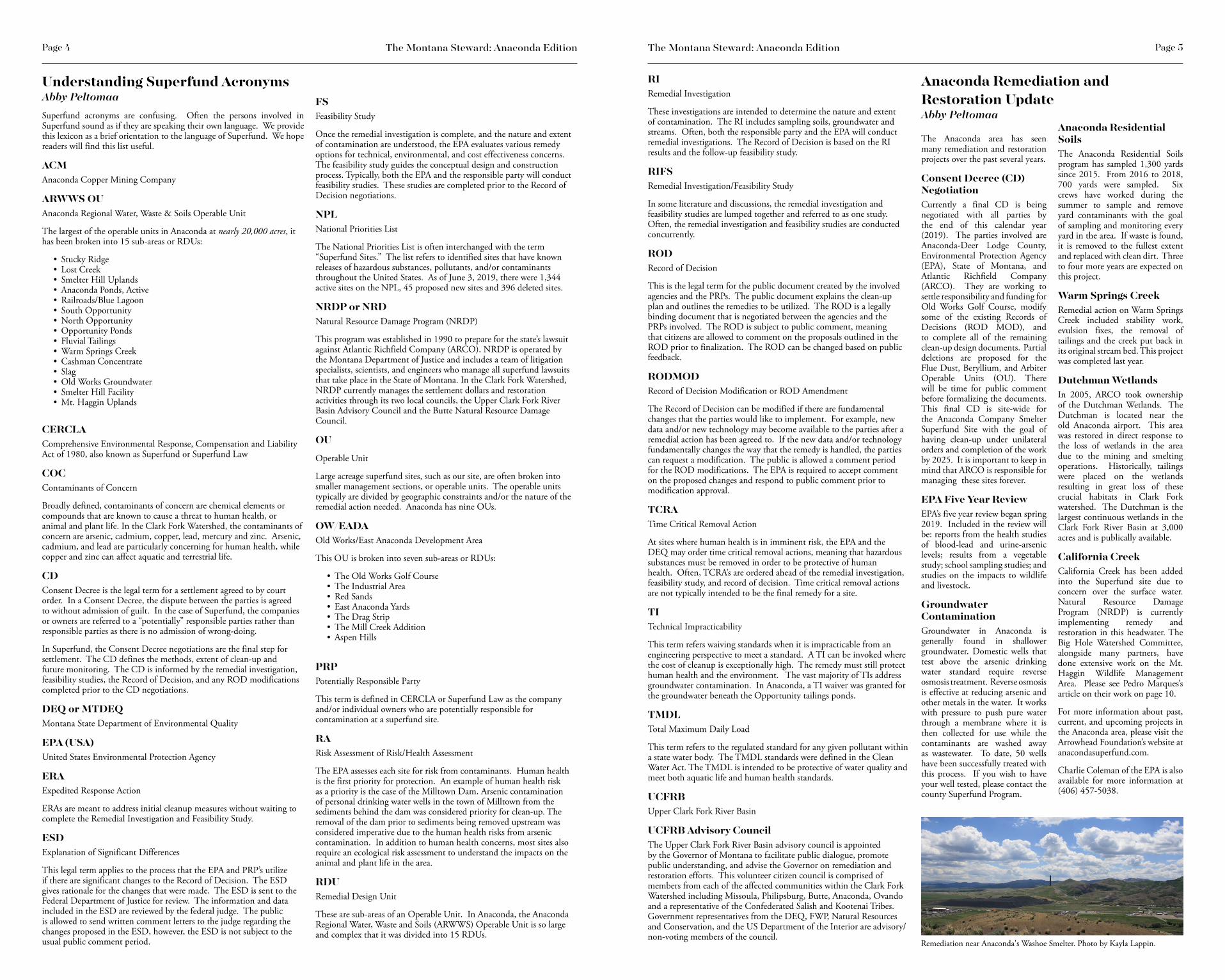
Anaconda Remediation and Restoration UpdateAbby Peltomaa
The Anaconda area has seen many remediation and restoration projects over the past several years.
Consent Decree (CD) NegotiationCurrently a final CD is being negotiated with all parties by the end of this calendar year (2019). The parties involved are Anaconda-Deer Lodge County, Environmental Protection Agency (EPA), State of Montana, and Atlantic Richfield Company (ARCO). They are working to settle responsibility and funding for Old Works Golf Course, modify some of the existing Records of Decisions (ROD MOD), and to complete all of the remaining clean-up design documents. Partial deletions are proposed for the Flue Dust, Beryllium, and Arbiter Operable Units (OU). There will be time for public comment before formalizing the documents. This final CD is site-wide for the Anaconda Company Smelter Superfund Site with the goal of having clean-up under unilateral orders and completion of the work by 2025. It is important to keep in mind that ARCO is responsible for managing these sites forever.
EPA Five Year ReviewEPA’s five year review began spring 2019. Included in the review will be: reports from the health studies of blood-lead and urine-arsenic levels; results from a vegetable study; school sampling studies; and studies on the impacts to wildlife and livestock.
Groundwater ContaminationGroundwater in Anaconda is generally found in shallower groundwater. Domestic wells that test above the arsenic drinking water standard require reverse osmosis treatment. Reverse osmosis is effective at reducing arsenic and other metals in the water. It works with pressure to push pure water through a membrane where it is then collected for use while the contaminants are washed away as wastewater. To date, 50 wells have been successfully treated with this process. If you wish to have your well tested, please contact the county Superfund Program.
Anaconda Residential SoilsThe Anaconda Residential Soils program has sampled 1,300 yards since 2015. From 2016 to 2018, 700 yards were sampled. Six crews have worked during the summer to sample and remove yard contaminants with the goal of sampling and monitoring every yard in the area. If waste is found, it is removed to the fullest extent and replaced with clean dirt. Three to four more years are expected on this project.
Warm Springs Creek Remedial action on Warm Springs Creek included stability work, evulsion fixes, the removal of tailings and the creek put back in its original stream bed. This project was completed last year.
Dutchman WetlandsIn 2005, ARCO took ownership of the Dutchman Wetlands. The Dutchman is located near the old Anaconda airport. This area was restored in direct response to the loss of wetlands in the area due to the mining and smelting operations. Historically, tailings were placed on the wetlands resulting in great loss of these crucial habitats in Clark Fork watershed. The Dutchman is the largest continuous wetlands in the Clark Fork River Basin at 3,000 acres and is publically available.
California CreekCalifornia Creek has been added into the Superfund site due to concern over the surface water. Natural Resource Damage Program (NRDP) is currently implementing remedy and restoration in this headwater. The Big Hole Watershed Committee, alongside many partners, have done extensive work on the Mt. Haggin Wildlife Management Area. Please see Pedro Marques’s article on their work on page 10.
For more information about past, current, and upcoming projects in the Anaconda area, please visit the Arrowhead Foundation’s website at anacondasuperfund.com.
Charlie Coleman of the EPA is also available for more information at (406) 457-5038.
Remediation near Anaconda's Washoe Smelter. Photo by Kayla Lappin.

Page 7Page 6 The Montana Steward: Anaconda Edition The Montana Steward: Anaconda Edition
Anaconda Company Smelter NPL Operable UnitsAbby Peltomaa
The Anaconda Company Smelter Site is 300 square-miles with Records of Decision (RODs) at five active operable units (OUs). Some of the OUs have been broken down into smaller remedial design units (RDUs).
This site was listed on the NPL in 1983 and there have been over 30 years of clean-up. Eighty percent of the work is complete. Half of the upland reclamation and open spaces has been completed with 12,000 acres reclaimed and 10,000 more to go. Over 1,300 residential and commercial properties have been cleaned up to date with three or four years left to go. The final Consent Decree for this site is slated by the end of this calendar year and deletion of the site by 2025. The following are the operable units of this site. Some have been completed and are currently being maintained while others are still ongoing. One or more RODs are anticipated to be amended this year.
Active OUsOU 15 - Mill Creek Operable Unit The remedy was selected in 1987 and included permanently relocating all Mill Creek residents. Demolition debris was removed and disposed, and contaminated soils were stablized. Construction of the remedy was finished in late 1988. Contaminated soils were subsequently removed under other OUs. Monitoring and maintenance of the vegetation is on-going. Portions of this area are currently being redeveloped. The site will be managed for reuse.
OU 11 - Flue Dust Operable UnitThe remedy was selected in 1991 and included stabilization of about 600,000 cubic yards of flue dust. A by-product of the smelting process, flue dust is the finely divided metal or metallic compounds that escape with the flue gases of a smelter or metallurgical furnace. Flue dust contains high levels of metals such as copper, arsenic, cadmium, and lead. Treated materials were placed in an engineered repository, which was required to include a liner, a leak detection and collection system, groundwater monitoring wells, and a cap. Long-term maintenance and monitoring have been on-going. Construction of the remedy finished in 1996. The site will be maintained in perpetuity.
OU 07 - Old Works/East Anaconda Development Area Operable UnitRemedy was selected in 1994 and included placement of engineered covers over waste, treatment of soils, surface water controls, upgrades or repairs to streambank levees,
replacement or repairs to bridges, institutional controls, long-term monitoring and preservation of historic features. OU7 consists of six sub-areas. They are: the Old Works Golf Course, the Industrial Area, Red Sands, East Anaconda Yards, the Drag Strip, the Mill Creek Addition, and Aspen Hills. Construction is complete at five of the six areas. Construction at the sixth area, the Industrial Area, is nearly complete. The site will be maintained in perpetuity and managed for reuse.
OU 16 - Community Soils Operable UnitThe remedy for residential soils was selected in 1996 and was modified in 2013. The work has included removal of arsenic-contaminated soils and replacement with clean soil. This remedy also called for the cleanup of future residential soils. The remedy for commercial/industrial areas and the active railroad area included placement of engineered covers. Construction of the remedy was finished in 2010. Operation and maintenance activities are ongoing. The 2013 modification to the Community Soils remedy included cleanup of lead-contaminated residential soil, expanding the controls program, and development of an interior dust abatement program. Implementation of this remedy began in 2015 and is ongoing. In 2017, the EPA addressed primary sources of interior dust contamination through sampling and cleanup. It called for removal of arsenic-contaminated soils and yards. This OU is currently in construction.
OU 04 - Anaconda Regional Water, Waste and Soils Operable UnitRemedy was selected in 1998 and was modified in 2011. The work included consolidation of miscellaneous waste materials, placement of engineered covers over waste management areas, treatment of contaminated soils, storm water controls and institutional controls, including the monitoring and regulation of domestic wells in groundwater areas. A Technical Impracticality Waiver for arsenic in groundwater has been applied to large areas of the site. The OU consists of 15 RDUs (see more about these RDU's on Page 7 and the corresponding map of these RDU's on pages 8-9). Remedial action is ongoing at most of these subareas. Over 10,000 acres have been remediated to date. Construction is expected to be completed over the next 10 years. This OU is currently in development.
OU 09 – Beryllium RemovalBeryllium was brought to the Anaconda Smelter. Metal combinations with beryllium were experimented with as alloys. When the experimenting was done, the plant was demolished and buried in the Opportunity Ponds. The beryllium was later removed in 1992. The beryllium was packed in containers and moved to a repository on Smelter Hill. There is a liner and leachate collection system in place and the groundwater is monitored. Construction was completed in 1996. This OU is considered under OU4.
OU 12 – Arbiter Removal The Arbiter saw experimentation on a new process in the 1970s. Instead of using heat, acid, temperature and pressure were used. The by-product of this process had a pH of 11 to 12. Removal started in 1992 and was completed in 1996. This OU is considered final under OU4.
The Anaconda Regional Waste, Water and Soils OUAbby Peltomaa
The Anaconda Regional Waste, Water and Soils Operable Unit (OU) has been divided into 15 Remedial Design Units (RDU)due to their complexity. The following is a brief summary of each RDU. A map of these RDU's can be found on pages 8-9. More information can be found on the Arrowhead Foundation’s website at anacondasuperfund.com.
RDU 1 – Stucky Ridge UplandsThis RDU includes approximately 4,000 acres of arsenic contaminated soils. Remedial work is required on approximately 2,500 acres and will include soil treatment, steep slope reclamation and construction of stormwater controls. Work has been completed on about a third of this RDU.
RDU 2 – Lost Creek UplandsThis RDU includes approximately 2,000 acres of arsenic contaminated soils adjacent to Lost Creek. Remedial work is required on approximately 1000 acres and will include soil treatment, steep slope reclamation and construction of storm water controls. Work has not started on this RDU.
RDU 3 – Smelter Hill UplandsThis RDU is over 5,000 acres and includes a high aresenic area adjacent to the smelter facility. Remedial work is required on approximately 2,500 acres and will include soil treatment, steep slope reclamation, and storm water controls. The high arsenic areas will also require access controls. Limited work has been performed on this RDU.
RDU 4 – Anaconda PondsThis RDU includes the 710-acre Anaconda Ponds tailings impoundment. Remedial work included capping the tailings with an 18-inch soil cover, and construction of storm water controls. Work has been completed on this RDU.
RDU 5 – Active RailroadThis RDU includes the active Rarus Rail line from Durant Canyon to the West Rail Yard in Anaconda. Remedial work requires the removal of waste materials that could impact ground and surface water or private property. It also requires the placement of rock material on the line to provide a barrier to waste materials to reduce human contact and further erosion. Wastes have been removed from the Blue Lagoon area as well as several other concentrate spill areas. The East and West Rail Yards, main line through Anaconda and portions of the main line to Durant Canyon, have been covered with rock. Remaining work at this RDU includes the replacement of two railroad trestles at Mill and Willow Creeks and removal of adjacent waste material.
RDU 6 – South OpportunityThis RDU is approximately 1,000 acres of arsenic contaminated soils and primarily requires soil treatment. Work on this RDU will be completed next year.
RDU 7 – North OpportunityThis RDU includes approximately 1,000 acres of Old Works fluvial deposits adjacent to Warm Springs Creek. Remedial work required the stripping and removal of the fluvial deposits, and treatment of remaining soils. Work has been completed on this RDU.
RDU 8 – Opportunity Ponds/BP-ARCO RepositoryThis RDU includes approximately 7,500 acres of the Opportunity Ponds tailings impoundment and adjacent soils. Remedial work required the capping of the 3,500 acre tailing impoundment with various cover designs and then revegetated. The tailings impoundment was divided into 20-acre units with the cover pitted to reduce the ponding
and infiltration of water into the tailings. Several million cubic yards of waste from Milltown, the Colorado Smelter in Butte, Silver Bow Creek, and the Clark Fork River have been consolidated into the Opportunity Ponds. Soils adjacent to the ponds were used in the cover design. These soil borrow areas were subsequently reclaimed to create nearly 1,000 acres of new wetlands which are popular with wildlife. The adjacent areas are also utilized to store stormwater from the smelter facility. With an interception trench at the toe of the ponds, these form a ground and surface water passive treatment system to effectively treat water that feeds a portion of the wetland system. This system will be monitored with a provision for additional treatment if it becomes necessary. Work has been completed at this RDU.
RDU 9 – Fluvial TailingsThis RDU is approximately 5,000 acres impacted by historic flooding from Silver Bow Creek. Remedial work is required on approximately 2000 acres that includes primarily soil treatment and some removal of the most contaminated materials. Work also included the removal of waste materials along a stretch of lower Willow Creek and stabilization of the stream banks. Work will be completed in this RDU next year.
RDU 10 - Warm Springs Creek This RDU includes approximately 4.5 miles of Warm Springs Creek impacted by fluvial deposits from the Old Works. Remedial work requires the removal of floodplain waste from two areas and the stabilization of stream banks. Work in this RDU is complete.
RDU 11 – Cashman ConcentrateThis RDU addresses approximately 25,000 tons of copper concentrate materials that were purchased for reprocessing. Remedial work required the disposal of these materials at Montana Resources where they could be incorporated into their leaching process. Work on this RDU is complete (not included on the map on pages 8-9).
RDU 12 – SlagThis RDU consists of the Main Granulated Slag pile, the Anaconda Landfill Slag site, and the West Stack Slag Site. The ROD allows for the slag to be reused for industrial purposes such as abrasives, roofing shingles and cement. Remedial work requires that these slag materials be managed to reduce any offsite migration of contaminants while slag is being processed, and to close the slag sites when slag is no
longer used. EPA and DEQ are currently re-evaluating the long-term management of the slag, and may require that portions be capped or closed depending on the current use.
RDU 13 – Old Works GroundwaterThis RDU addresses groundwater underneath the Old Works area. Remedial work requires monitoring of the groundwater cadmium plume with a provision for additional work if the plume migrates beyond the established point of compliance. Monitoring is being performed under the Ground Water Management Plan.
RDU 14 – Smelter Hill FacilityThis RDU includes approximately 1,500 acres of the former Anaconda Reduction Works Complex. Remedial work requires that approximately 1,000 acres of the waste management areas be capped with a soil cover, adjacent soils treated, and the construction of storm water controls. Work at this RDU will be completed this year.
RDU 15 – Mt. Haggin UplandsThis RDU includes approximately 5,000 acres of arsenic contaminated soil within the State’s Mt. Haggin Wildlife Management Area. This RDU is located at the headwaters of Willow and California Creeks, and is adjacent to Mill Creek. Remedial work requires primarily steep slope reclamation and construction of storm water controls. Work is being performed by the Montana Natural Resource Damage Program and is over half completed.
West Galen Expansion AreaThis area includes approximately 6,500 acres of low-level contaminated soils. Remedial work requires soil treatment on approximately 4,500 acres. Work in this area is completed.
Dutchman Expansion AreaThis area includes approximately 5,000 acres of well-vegetated high arsenic soils. This area is also the largest contiguous wetland in the upper Clark Fork River Basin. Remedial requirements include use and access controls to reduce human exposures, and minimizing the degradation of vegetation to reduce soil erosion and runoff. Work is complete in this area (not included on the map on pages 8-9).
Lime piles on the back side of Stucky Ridge. Photo by Kayla Lappin.
A view of remaining slag near Smelter Hill. The green hills surrounding the black piles have been remediated with cap and cover system.
We'd like to thank the Arrowhead Foundation, EPA websites, as well as Charlie Coleman, for help with this article.
Contacts:Arrowhead Foundation118 East 7th Street Anaconda, MT 59711 406-563-5538
EPACharles Coleman Remedial Project Manager (RPM) 406-457-5038 [email protected]
MT DEQJoel Chavez Project Officer 406-841-5031 [email protected]
NRDPGreg Mullen Environmental Science Specialist 406-444-0228 [email protected]
A view of Mount Haggin from Stucky Ridge. Photo by Kayla Lappin.
Grass grows along Stucky Ridge and Smelter Hill on remediated caps. Photo by Kayla Lappin.

Page 9Page 8 The Montana Steward: Anaconda Edition The Montana Steward: Anaconda Edition
Active Railroad
Stucky Ridge Uplands
Lost Creek Uplands
West Galen Expansion Area
Old Works Groundwater
North Opportunity
Warm Springs Creek
Opportunity Ponds/BP-ARCO Repository
Slag
Anaconda Ponds
Smelter Hill Facility
Smelter Hill Uplands
Mt. Haggin Uplands
South Opportunity Ponds
Fluvial Tailings
Anaconda and Opportunity Remedial Design Units (RDU's) within the Anaconda Regional Water, Waste and Soils Operable Unit
Anaconda
Opportunity
Fairmont Hot Springs
Warm Springs Ponds
Warm Springs
1-90
1-90
1-90

Page 11Page 10 The Montana Steward: Anaconda Edition The Montana Steward: Anaconda Edition
Mounta Haggin Waste Management AreaPedro Marques
Somewhere between an opportunity and wisdom, there is a place for innovation to spark and for transformative projects to take root. In one quiet corner of Southwest Montana, along the highway between Opportunity and Wisdom, 120 years separates two such transformative projects. This is the story of the degradation and restoration of the headwaters tributaries of the Mount Haggin Wildlife Management Area.
In 1864 the first gold in the Big Hole watershed was hit in French Gulch, a cold, wet, headwater tributary of French Creek/Deep Creek, due north of the apex of the Big Hole River’s long U-turn between the southern Pintler (Anaconda) and northern Pioneer ranges. Gold panning and sluicing for the easiest available gold, which yielded as much as $5/pan (in 1860s dollars!), was completely exhausted by 1877, at which point more intensive hydraulic mining operations began. Large dredgers were later brought to the French Gulch mining claims in 1895. Typical of mining towns of the era, the town of French Gulch was built, boomed and busted in less than 40 years. Streams and floodplains targeted by mining operations were completely uplifted, materials sifted through, channels relocated, and massive piles of cobble left behind. Streams were often left in strengthened, incised channels.
Around 1904, with placer mining waning, W. R. Allen, who was born in French Gulch in 1871 and later became Lieutenant Governor of Montana, had purchased many of the local claims and his namesake company established large-scale logging activities for the booming towns of Anaconda and Butte. Timber became the new resource of interest on Mount Haggin. From 1906 to 1909, a massive sale removed 79 million board feet of timber. The productivity of the landscape and the totality of its extraction cannot be understated.
This sale included construction of the famous log flume which conveyed logs from Mount Haggin over the Continental Divide and into the Clark Fork Valley. While the mining, logging and extraction of natural resources from the area was devastating to ecological systems, equally impressive and admirable was the ingenuity and tenacity of the teams of people who came together to build and maintain the infrastructure that achieved such large-scale land transformation.
And then came the smoke. The Washoe Smelter, the “lungs” of the massive Butte-Anaconda enterprise that produced enough copper to drive the electrification of the United States, also produced a staggering amount of airborne pollution, which concentrated on the higher elevations of the Continental Divide between Mount Haggin and Sugarloaf Mountain. Records from the day estimate up to 60 pounds of airborne arsenic, copper, lead, cadmium and zinc, as well as toxic sulphur dioxide, landed on the hills
every day. Vegetation that survived the massive logging enterprise had no chance of surviving the toxic plume. With nothing holding soils in place, particularly where soils were formed from white, volcanic welded tuff, the snow, rain and wind easily carried topsoil and sediment downhill.
Fast-forward to 2012. Many acres of the uppermost slopes of Sugarloaf Mountain on both sides of the Continental Divide have lost 18 to 24 inches of soil. This is easily observed by noticing the exposed lateral and tap roots of perched tree stumps across the landscape which have not decomposed because of the harsh summers, freezing winters and constant wind.
The mountains of sediment that gushed downhill over 100 years, exacerbated by leaky log flumes that regularly spilled over, created countless gullies. These gullies are up to 40 feet deep and can transport water and sediment straight downhill at maximum velocity. During high-flow events, nearly every tributary in the area spikes for one or more of the five
contaminants of concern. The landscape is effectively a network of sediment superhighways. Ranchers on the Big Hole River downstream of French Creek report that the streams run white after storms.
Beyond the reach of the toxic stack and sediment plumes in the French Creek/Deep Creek drainage, most streams are listed by the Department of Environmental Quality (DEQ) for sediment and habitat impairments. Placer mining left streams and floodplains upside down, with minimal fine sediments or spawning gravels, instead covered by the large, cobble alluvium that used to lie underground. Sagebrush and lodgepole pine floodplains indicate substantially drier systems than what was there before gold mining.
Restoring the DamageBy 2014, three state agencies, driven by their own mandates and resource concerns had begun to focus substantial resources in the Mount Haggin Wildlife Management Area (WMA). The Natural Resource Damage Program was developing restoration plans for the Mt. Haggin Uplands Injured Area, a 5,000-acre area around Sugarloaf Mountain on both sides of the Continental Divide. Montana Fish Wildlife and Parks was scoping a plan to install a fish barrier in lower French Creek to create a native fish stronghold across over 40 miles of headwater tributaries, and the Department of Transportation had begun moving the roadway, MT 569, out of the willow bottoms of French Creek and onto the drier bench.
Seizing the opportunity, the Big Hole Watershed Committee began to stitch together these different restoration pieces into a coherent vision, and became the glue for what has become a fast-moving restoration train supported by a dozen funders. We hired staff with restoration expertise in 2016 and 2018, and currently manage a
portfolio of projects in the WMA valued at nearly $1.2 million. These projects include the drainages of Joyner Gulch, Muddy Gulch and upper Willow Creek to the north, and California Creek, French Creek, Oregon Creek and French Gulch in the Big Hole watershed.
Across these projects, we have fostered a cooperative spirit with our agency partners by understanding their resource objectives and fitting our on-the-ground solutions to advance those goals. Coupled with highly-talented design engineers, we’ve been able to design projects that remove the primary impairments to the system and give natural systems the kick-start they need to heal on their own.
We have consistently found that controlling the movement of sediment by water is key. Reference sites across the WMA are dominated by beaver ponds and stream systems that regularly overtop their banks and saturate floodplains. When we increase the landscape’s ability to capture and hold sediment by getting perennial channels up and out of their banks, multiple resource objectives come together:
-Floodplain soils get charged up with water. Water moving through soil underground moves slower and stays cooler, so there is more cold water available later in the season.
-Fine sediments move out of surface waters and stay out of spawning gravels, improving future fish habitat.
-More water on the floodplain encourages more riparian plants like willows and aspen. Once local beaver have enough of their favorite foods in a given location, they’ll set up shop and ramp up their ponding and wetland creation. As a keystone species, the benefits of beavers to all other species is well documented.
Across the WMA, we’ve sought to mimic natural recovery processes to achieve what are predominantly sediment-related impairments.
Beaver MimicryAcross our projects, the dried up floodplains of former beaver pond meadows are great for growing lodgepole pine. And lodgepole pine make great material for installing leaky dams known as beaver mimicry structures or beaver dam analogues (BDAs). We have installed over 600 BDAs across the Injured Area of the Superfund site along California Creek and Muddy Gulch, small tributaries that emerge from groundwater seeps along the Continental Divide. Each structure builds up sediments and raises the height of the stream bed. Now, during high water events, instead of rushing downstream, these streams spill out onto the floodplain and saturate previously bone-dry soils. With the long-Log Extraction near Anaconda.
Log flume which conveyed logs from Mount Haggin over the Continental Divide and into the Clark Fork Valley
Exposed lateral and tap roots of perched tree stumps.
Heavy sedimentation.
term focus of the beaver dam analogue project, we’ve been able to install three generations of these structures in some locations. We are using drone surveys to estimate the amount of sediment we are catching with each structure. In 2016, we measured that about half a ton (500 pounds) of sediments were captured by each structure. After the third generation, we estimate that between 3 to 10 tons of sediment are captured behind each structure. More important, we’re seeing upland grasses converting to sedges and rushes, and willow and aspen groves thriving nearby.
Floodplain connectionIn French Gulch and Moose Creek, where placer piles covered most functional floodplains and the stream was relegated to a straight, narrow chute, we removed 30,000 cubic yards of material. We also designed a new stream channel to regularly spill out of its banks, creating 17 acres of new wetlands
along 3 miles of channel in the process. We estimated that after one year, we are reducing 448 tons of sediment/year from that system. More important, we’ve set the conditions for natural processes to develop the wet willow bottoms that are found in our reference
areas (unimpacted areas).
Slope and gully erosion controlIn the highly-eroded uplands of the Mt. Haggin Injured Area, we learned through investigations and small-scale demonstration projects that the bare soils are not toxic to plants, unlike the slickens (tailings) in the riparian corridors of the Clark Fork River. On those bare slopes, the addition of slow-release organic fertilizer has jump-started vegetation growth. With each new clump of grass or forb, we make it harder for sediment to find its way downhill.
In large gullies, we use locally available lodgepole to create gully plugs to capture sediment and create locations for the local
seed bank to germinate, further slowing erosion. Over six years we have installed hundreds of check structures of all shapes and sizes. In 2018, we punched a temporary road into the Continental Divide, and using heavy equipment installed over 2,500 dozer basins on the slopes and installed gully dams and check structures – enough to capture nearly 3,000 tons of sediment.
Together these projects are having a transformative impact in the Mt. Haggin WMA and all our partners are seeing resource benefits. More important, by setting the stage for nature to heal itself, our projects are decreasing the long-term ecological maintenance needs of the area, setting the stage for the successful reintroduction of the second largest native fish project in Montana, and greatly improving the quality of the landscape for the recreationists that enjoy this spectacular public land of ours.
Vegetation growth with slow release organic fertilizer.
A new stream channel designed to regularly spill out of its banks.

Page 13Page 12 The Montana Steward: Anaconda Edition The Montana Steward: Anaconda Edition
Voices of the Watershed: What Do You Want for the Future of Anaconda?
I would like to see recycling bins on the streets because many people don't have them, and don't feel like driving to the place where they break the garbage down. Also if plastic gets in streams that go to the ocean, animals could die.
As a kid living in Anaconda, I like to take my dogs for walks, but whenever I do, I can't ever find any doggie bag dispensers. I would also like to see a dog park put into the town. My dogs would be glad to have a big place to run around without being in danger of being hit by a car.
I would like to have a water park in Anaconda. An actual water park close to us for play is wonderful to think about. I live in between Butte and Anaconda but, it would be wonderful to have an excuse to stay in Anaconda.
Fred Moodry 6th Grade Students
I want my community to start picking up more garbage. I also think the community should start recycling because there are tons of paper and water bottles that go to waste.
Maybe during Art in the Park you can have recycling bins around the park because a lot of trash is left behind.
Anaconda is a great place to live, however there are a few problems. For example there are been many times my friends and I have needed something to do. I know there has been talk of a rec center and I think that would be a great idea. Another idea is an arcade with classic games and snacks and music. An idea one of my peers had was a roller rink, I cannot even tell you how many times I wished we had somewhere to rollerblade/skate. I think this would make a tremendous change in our community.
In the future, I would like to have more recycling happen in Anaconda.
I think that if we picked up a lot more and quit littering as much as we do, our community would be a lot nicer.
I want Anaconda to make it so that there is no slag pile and so there are more trees near the pile.
What I want to see in Anaconda is no trash around town and more places/houses for homeless people.
What I would like to see in Anaconda is a larger variety of books in the public library. I also would like to see an indoor water park. I would like a new museum. I also think we should get an organic food center so it will encourage people to eat healthy. Plus, a new animal shelter.
I want Anaconda to get rid of the slag.
I would like to see people not litter and clean up parks, playgrounds, our school. I would also like to see recycling.
I would want to see the streets and sidewalks plowed. I would also want to see people helping the older people with cleaning their driveways and sidewalks for free.
I want Anaconda's great smoke stack to be preserved. I would also like to see some things passed in Anaconda for kids to have the best education possible.
I would like to have bike trails all around town and I would like more cross walks in certain places.
I would like my future Anaconda to have an Anaconda Fair for 4-H.
I would like my future community to be recyclable. Also, we could have a homeless shelter.
Anaconda High School Students
In the future, I would like to see more color in our grass. The majority of grass in Anaconda tends to be very yellow if it's there at all. So, it'd be nice to see some green in our ground rather than the weed-like fields that seem to be there. Apart from that, the changes I would want to see in Anaconda would mainly revolve around the environment being healthier. Better air quality, soil, etc.
In the future, I would like to see Anaconda become known as a community that is willing to participate in the cleanup of our town. I don't think that we have many clean up projects in Anaconda which is really a downer. If we held more cleanups each year and made them a yearly cause, I believe that Anaconda would become a better environment for everyone that lives here. It would cause more people to visit and have a greater impact on our local businesses.
I envision Anaconda to have a better landscape surrounding the community as a result of a cleanup of our soil.
I would like to see the slag pile cleaned up.
i want a community that helps out with pollution, recycling, and making this town a better place to live.
Our community has actually done a lot to make our town look so much healthier than it used to. I would still like to see more trees on the mountains surrounding us and I would also like to see more work done in our Washoe Park area.
I want our community to be safe and peaceful. I want the streets to be clean. I want to see children running around and playing. I just want us to have a nice community.
My community should remove the slag pile that sits near the smelter, not only is it toxic but its also very dangerous to the wild life and nature around it.
In the future, I would like to see our community be renovated and for most of the contaminants that are around this environment to be gone. I think that it would take a lot of time and effort, but it would be a step in the right direction to make this town beautiful again.
I would like to see the town and surrounding areas become more filled with plants to help stop the weathering away of top soil. There are some areas I notice that seem sandy and do not have proper nutrients or care to be able to sustain vegetation and keep the dir t from washing away with snow, rains, and wind.
I want a clean, non-toxic community with people moving back in to this town for more jobs and cleaner safe environment for their children.
A prosperous community that embraces their history and appreciate the natural resources that have been gifted to us.
Anaconda is a beautiful little community town located in the state of Montana. Anacondas beauty lies deep within, from the beautiful wildlife to the fishing and hunting accessibility.
I would like to see Anaconda get a waterpark.
I would like my community to have more trash cans and would like them to be cleaned regularly.

Page 15Page 14 The Montana Steward: Anaconda Edition The Montana Steward: Anaconda Edition
Teacher Feature: Bob OrrinoAbby PeltomaaEditor’s Note: Bob began with CFWEP about 15 years ago and has since expanded on CFWEP programming in his own classroom in every way possible. From talking about Anaconda’s past to Montana’s several trout species in our watershed, Bob not only extended his curriculum on these topics, but improved the knowledge of his students as well. He is always working to connect students’ learning to their surroundings. The students of Anaconda are fortunate to have Bob working in their class. All of our host teachers are invaluable partners to CFWEP in creating a legacy of stewardship for our state’s natural resources.
How many years have you been teaching?
This will be my 26th year of teaching.
Are you born and raised Anacondan?Yes, as a matter of fact, I live in the house that I grew up in.
Describe your style of teaching.I encourage students to engage in their learning process and to take ownership in their knowledge. Most of all, I try really hard to give students real-life connections. We live in such a unique place with so many opportunities for outdoor recreation that if I can have students grow up to be stewards and take ownership of this great area, I think I have done my job as a middle school science teacher.
When did you first get started working with CFWEP and what hooked you?I started with CFWEP in 2004 one year after it was formed. I got hooked immediately because I am very interested in the mining and smelting history of Butte and Anaconda. I feel strongly that the youth and adults that live in this area need to know the history of mining, whether good or bad. This history will give us the opportunity to learn from past mistakes. As a result, it helps all of us become more compassionate as people and more impartial as decision-makers, and to take ownership of the place we live.
Washoe Park Trout HatcheryAngela Smith, Hatchery ManagerWashoe Park Trout HatcheryMontana Fish, Wildlife & Parks
What has kept you interested and working with the CFWEP program?First of all, it is the people especially, Abby and Dr. A. They bring so much passion to the students as well as myself.
CFWEP brings so many opportunities to the students. The fish dissection gets the students aware and involved in our watersheds.
The Restoration Education Program teaches students about the past and ongoing restoration and remediation of our watershed.
It is very refreshing when CFWEP spends several days in my classroom. The students get a different teaching perspective which reinforces my passion for our watershed.
What do you want for the future of Anaconda?I want Anaconda to keep celebrating its history. Last year we had the 100 year celebration for the smoke stack. This was the first time that local residents from near and far were able to take a bus ride to the smoke stack and talk about the history of smelting.
We need to record our history for future generations growing up in Anaconda so they know why this city exists.
What do you think is the most important thing for Anaconda going forward?First and foremost we need to hold the EPA (Environmental Protection Agency) accountable for the restoration and remediation of our watershed. The Butte, Anaconda and Clark Fork River Superfund cleanup is the largest Superfund complex in the nation. People don’t realize what that really means to the watershed, as well as the land that was affected by the smelting process.
Residents of the Clark Fork Watershed must be educated about the risks of living in a superfund site and teach future generations how to care for our cities as well as our lands.
What do you want your community to be like in the future?I am all about jobs. I fully support mining and logging, but going forward we need to learn from our mistakes. I fear too many kids who grow up here will have to leave this place that they love to make a living wage.
Editor’s Note: The Washoe Park Trout Hatchery has been a partner of CFWEP since our inception. Without their commitment to our program, we would not be able to deliver this engaging curriculum across the Clark Fork Watershed. They provide trout for our Trout in the Classroom dissections, and provide tours for school groups and our annual fly fishing-campers. We are currently working with hatchery scientists to brainstorm additional opportunities for partnering in trout research projects.
The Washoe Park Trout Hatchery was established in 1908 and was the first state-run hatchery in Montana. The Butte, Anaconda and Pacific Railroad donated the four acres of land for the hatchery facility, and the water rights were granted by the Anaconda Copper Company. The Washoe Park Trout Hatchery (WPTH) was built adjacent to historic Washoe Park in Anaconda, Montana, at the height of copper mining activity in the area. The project was initiated with help from local industries and the support of a strong, local sportsman’s club. The manager of
CFWEP Fly Fishing Campers Tour the Washoe Park Trout Hatchery
the Anaconda smelter was also a member of the Montana Fish and Game Commission and obtained support from the legislature to fund the hatchery’s construction.
The current mission of the Washoe Park Trout Hatchery is to maintain Montana’s westslope cutthroat trout conservation brood stock, known as the M012. Brood stock are adult fish that are raised and maintained at the hatchery for the purpose of breeding. The hatchery maintains the health and genetic integrity of the M012 brood stock and supplies eyed-eggs (eggs with developing embryo fish) to other hatcheries in the state. The progeny (offspring) of the M012 are used for multiple management objectives, including population management, urban fisheries, native species restoration and research. A second facet of the hatchery’s mission is to provide public outreach and education. This mission is accomplished by various means including the maintenance of an exceptional interpretive center, classroom education, and hatchery tours.
Stucky Ridge UpdateGreg MullanIn a 2008 settlement, The Atlan-tic Richfield Company (ARCO) agreed to do remedy and resto-ration on the state lands of Stucky Ridge and Mount Haggin. These upland areas were heavily impact-ed by historic smelting and looked very different from today. Both areas were virtually absent of veg-etation, other than noxious weeds. Erosion on the site was rampant. Many gullies had opened up over
the sites, carrying low pH (acidic) materials to the areas below. The pH of soils was as low as 3.5 in some places. Following the settlement, planning and sampling began in 2009 and 2010. In 2011, work began in ear-nest to address the grade and slope of the area, repair the major gullies, add a lime amendment, and cover with a native plants seed mix and
Bob and Theresa Orrino
CFWEP Fly Fishing Campers Tour the Washoe Park Trout Hatchery
Lime piles on Stucky Ridge. Photo NRPD.Stucky Ridge after grading. Photo NRPD.
WASHOE PARK
HOSPITAL
WEST ANACONDARR YARD
MITCHELLSTADIUM
COURTHOUSE
COMMONS
BENNYGOODMAN
WITHIN ANACONDA CITY LIMITS
. 0 500 1,000 1,500 2,000250Feet
DRAWN BY: DDDDATE: OCTOBER 2017 DOC: CSOU_Status_Owner.mxd
307 East ParkSuite 301AAnaconda, MT 59711
PROJECT: 3037-2017-102
CSOU STATUS 2017
Figur
e Exp
orted
: 10/1
6/201
7 By
: ddo
brine
n Us
ing: D
:\ARC
O\Pr
ojects
mxd
\2017
\CSO
U_St
atus_
Owne
r.mxd
SCALE: 1 " = 500 '
Woodard & Curran shall assume no liability for any of the following; 1. Any errors, omissions, or inaccuracies in theinformation provided regardless of how caused or; 2.Any decision or action taken or not taken by the reader in relianceupon any information or data furnished hereunder.
Note: the CSOU RAWP addresses residential yardsoutside the city limits not shown on this map
LegendRailroad
Ownership Boundaries
Scheduled/Sampled/Completed
No Response/Denied
Commercial/ADLC/School
Other RDU
Anaconda Community Soils Operable Unit : Have You Had Your Yard Tested?The communities of Anaconda, Opportunity, Crackerville, Fairmont, Galen, and Warm Springs all exist within the Community Soils Operable Unit. They are eligible for free yard testing for elevated levels of contaminants (such as arsenic and lead) from historic smelting operations.
fertilizer. The lime amendment (using sugar beet lime) was used at about 22 tons per acre over the 310 acres that were restored. The pH of soils today ranges from 7.2 to 7.3 (neutral levels) and main-tains a healthy population of native plants. Noxious weeds have been reduced by 95% on the site.
These state lands have been re-stored through the efforts of the
Natural Resource Damage Pro-gram (NRDP) and ARCO work-ing together to problem-solve and create healthy uplands. Uplands are connected to the riparian areas of the Clark Fork Watershed. If left unaddressed, unhealthy soils and historic wastes could have contin-ued into streams below these sites. The Stucky Ridge site is completed and now is moving into the moni-toring stage.
EPA and Atlantic Richfield are making some changes to the testing process to ensure that yards are remediated effectively. Previously, residential soils exceeding an averaged arsenic concentration of 250 parts per million (ppm) were remediated. The new update removes the averaging of test results. Any part of a residential area
that exceeds the 250 ppm limit, will be remediated. Properties that had the previous testing and the average did not initiate action will receive information in the mail if action will be taken.
The map below shows all of the yards (in green) that have been
scheduled for testing, sampled for testing or remediated.
Residents that want to request yard testing can contact Water Environmental Technologies (WET) at (406) 563-7476.
This map shows soil testing, soil sampling, and completed work within the city of Anaconda, which is located within the Community Soils Operable Unit.

Page 16 The Montana Steward: Anaconda Edition
Ask Dr. A: What is the Origin of Anaconda Continued from page 1.
Later in 1881 when Daly bought the Anaconda Mine from Hickey, Daly kept the name. It was here in the Anaconda Mine that Daly first came to realize how rich Butte’s ores were in copper. The copper that came out of the Butte hill eventually resulted in the United States becoming the
world’s leading copper producer, bringing a very bright spotlight to southwest Montana’s Upper Clark Fork watershed. For Daly, it was this discovery, and the need to process tons of ore and to house the workers, that eventually led him to found the town of Anaconda. By 1919, the Washoe Reduction Works with its 585 foot
smokestack, the Anaconda Smelter Stack, was the world’s largest non-ferrous processing plant and the stack was the world’s tallest masonry structure.
After 100 years of the smelter serving as Anaconda’s largest employer, the smelter closed in
1980 leaving about a quarter of the town’s workforce out of a job. Such huge job losses have killed many towns, turning them into ghost towns for tourists to visit. But not Anaconda – she persists. In the 1930’s, considered Anaconda’s heyday, the population was estimated at about 12,500, which is about 3,000 less than the 9,100 people who still call Anaconda home. The hard-working, loyal townsfolk that remain are the best of the best. To me, Anaconda is like a
jewel covered in the dust of her notable history. Every wipe of cloth to clean her reveals more of her bright treasures. Whether you are interested in home-cooking or fine dining, interested in shopping unique boutiques or hunting for treasures in thrift stores, interested in visiting Montana’s only cutthroat trout hatchery or playing a few rounds on the Old
Works Golf Course (designed by Jack Nicklaus), there is something for everyone in Anaconda.
There are not that many books written about Anaconda, yet most who take the time to get to know her agree there should be plenty more.
If you are interested in learning more, check out these fine books:
• Smoke Wars: Anaconda Copper, Montana Air Pollution, and the Courts, 1890-1924 by Donald MacMillan;
• Anaconda, Montana: Goosetown and West of Main by J. Ray Haffey;
• Anaconda Montana: Copper Smelting Boomtown on the Western Frontier by Patrick F. Morris;
• Anaconda: Labor, Community, and Culture in Montana’s Smelter City by Laurie Mercier.
Anaconda-Deer-Lodge County Courthouse.
Club Moderne. Anaconda, Montana.
The Clark Fork Watershed Education Program (CFWEP) has served Anaconda Montana students and teachers since 2005.