analysis in 9.2: overlay. analysis usually starts with selection… why? because –many steps in...
TRANSCRIPT

Analysis in 9.2:
Overlay

Analysis
• Usually starts with selection…• Why?• Because
– Many steps in analysis are simply selection by• Attribute OR• Location
– Most of the OVERLAY functions’ operations work with selected features
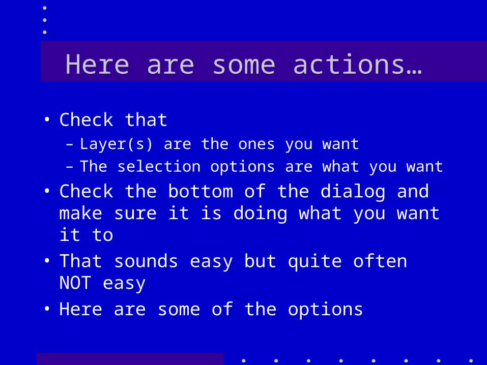
Here are some actions…
• Check that– Layer(s) are the ones you want– The selection options are what you want
• Check the bottom of the dialog and make sure it is doing what you want it to
• That sounds easy but quite often NOT easy
• Here are some of the options

Options: Intersect

Options:Touch Bndy of…
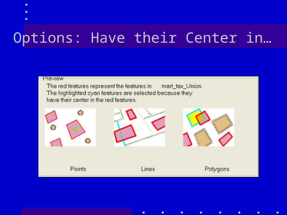
Options: Have their Center in…
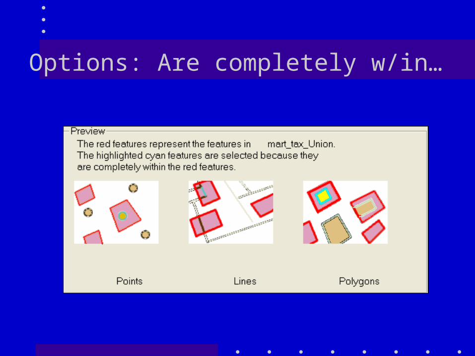
Options: Are completely w/in…
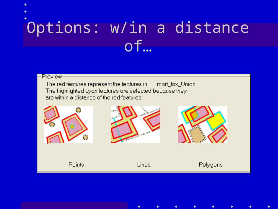
Options: w/in a distance of…
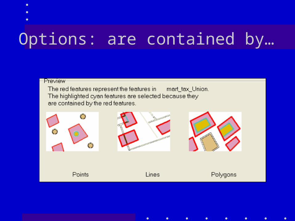
Options: are contained by…
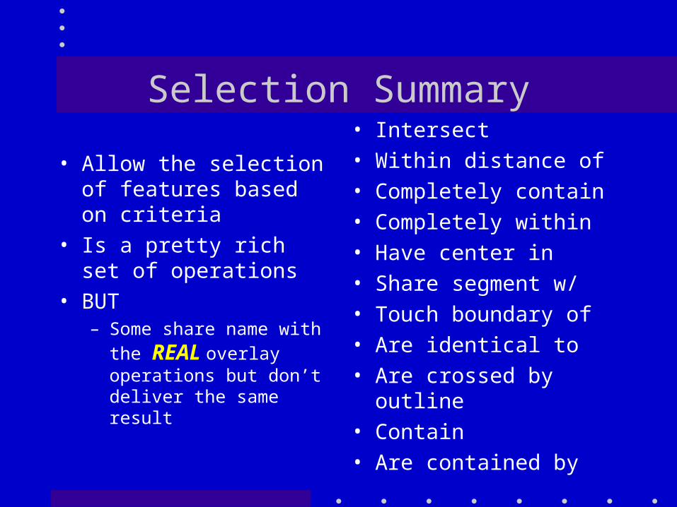
Selection Summary
• Allow the selection of features based on criteria
• Is a pretty rich set of operations
• BUT– Some share name
with the REAL overlay operations but don’t deliver the same result
• Intersect• Within distance of• Completely contain• Completely within• Have center in• Share segment w/• Touch boundary of• Are identical to• Are crossed by
outline• Contain• Are contained by

Overlay Operations
• Overlay operations are like the “select by location” functions but not exactly the same.
• Both use two layers– Select by location just selects
features in one of the layers– Overlay operations create new
feature classes

Toolbox

Overlay: Erase• From Help: Erase feature removes a chunk of
the input feature• It is important to keep Input and Erase feature
correct or GIGO

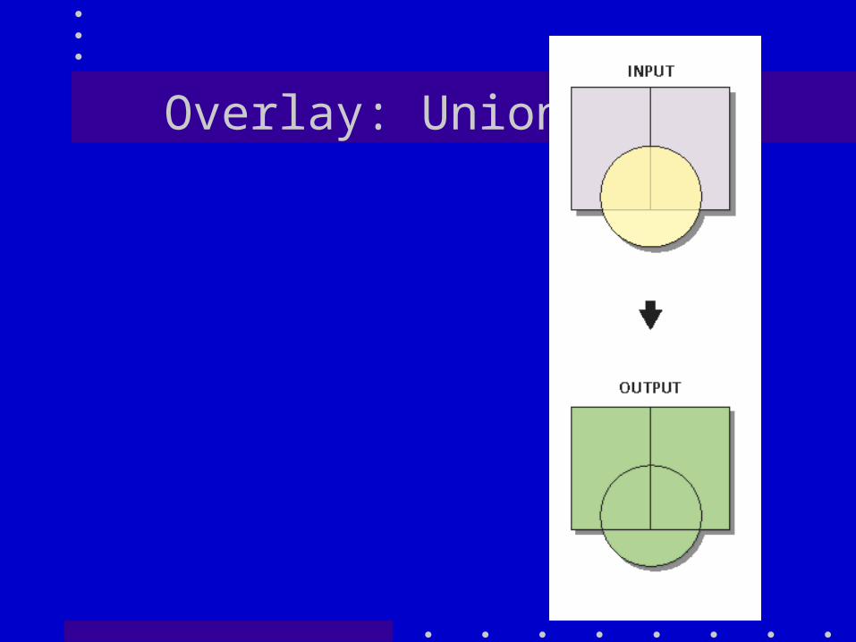
Overlay: Union
• This computes a geometric intersection of the input and output feature classes . ALL features will be written to the output feature class with the attributes from both.
• Or: This tool builds a new feature class by combining the features and attributes of each feature class.
Overlay: Union
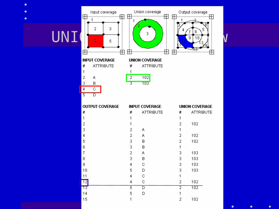
UNION: another view
Overlay: Identity• Computes a geometric intersection
(logic) of the input and identity features• Input features (or portions thereof) that
overlap the identity features will get their attribute features from the identity features
• To put it another way: combines the portions of features that overlap the identity features to create a new feature class.

Overlay: Identity• Computes a geometric intersection
(logic) of the input and identity features• Input features (or portions thereof) that
overlap the identity features will get attribute features from the identity features
• To put it another way: combines the portions of features that overlap the identity features to create a new feature class.
Clips by the Input feature and then UNIONS what is
left.

Overlay: Intersect• Computes the geometric
intersection of the input features or portions of features COMMON to all layers.
• This tool builds a new feature class from the intersecting features common in both feature classes. Available with any ArcGIS license.

Overlay: Intersect• Computes the geometric
intersection of the input features or portions of features COMMON to all layers.
• This tool builds a new feature class from the intersecting features common in both feature classes. Available with any ArcGIS license.
Intersect is NOTthe same as
Identity

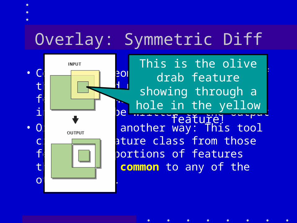
Overlay: Symmetric Diff
• Computes a geometric intersection of the input and update features. Any features COMMON to ONLY one of the inputs will be written to the output
• Or to put it another way: This tool creates a feature class from those features or portions of features that are not common to any of the other inputs.
This is the olive drab feature showing
through a hole in the yellow feature!

Overlay: Update
• Computes the geometric intersection of the input and update features. The attributes and geometry of the input features are replaced by the update features.
• This tool updates the attributes and geometry of an input feature class or layer by the Update feature class or layer that they overlap

Overlay: Summary
IDENTITY INTERSECT SYM-DIF UNION UPDATE

Buffer
• Buffering is an additional tool used in Analysis. Not
Dissolved
Dissolved =All

Summary
• The analysis tool in ArcGIS are very powerful
• And fairly easy to understand … one at a time!
• It is use by combining the overlay and selection tools to solve a problem that is the problem!

A Problem
• Find location for a laboratory– Within 300 meters of a sewer line– NOT within 200 meters of a stream– Parcel in a specific landuse (900 is forest)– Not on steep slopes (<=20%)– >=100 acres but less than 200 acres
• THIS IS A CLASSIC LOCATION THIS IS A CLASSIC LOCATION PROBLEMPROBLEM

Sewbuf300
BufferSewersw/in 300m
Streamsnot w/in
20m
SewerOKERASE
Landuse:Lucode =?
Slope<=20%
Strmbuf20
Buffer
OK sitesIDENTITY
Land OKIDENTITY
Of selectedpolys
Query
Query

Booby Trap
• Select by location using Intersect does not give the same results as Overlay Intersect

Sel by Location: Intersection• Intersected
Parcels w/ Cover with Ag Selected
• The red outlines are the selected parcels
Lets Zoom In ----
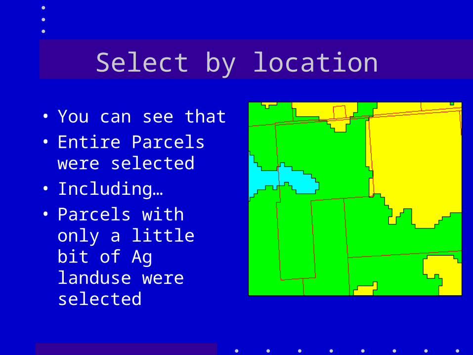
Select by location
• You can see that• Entire Parcels
were selected• Including…• Parcels with only
a little bit of Ag landuse were selected

Overlay Intersection• BUT THE RESULT IS VERY DIFFERENT!
Red outlines are the parcels selected by Select by theme
Green are the result of the Overlay

Comparison

So you have to be careful!
• Exercises 7a and 7 b have you experiment with some simple layers
• And I will be throwing some relatively simple problems your way to provide more practice
• And I will be changing the schedule at bit too (what else is new?).