analysis of aridity indicators in the deliblato · pdf file99 analysis of aridity ndicators h...
TRANSCRIPT

97
Ratko KadovićPetar SpasovYousef Mansour Ali BohajarSnežana Belanović Simić Olivera Košanin
ANALYSIS OF ARIDITY INDICATORS IN THE DELIBLATO SANDS
Abstract: Deliblato Sands are located in the southern part of Banat region in Vojvo-dina province. According to the estimated changes of basic climate parameters in this part of the Republic of Serbia during past decades very strong rise in annual air temperatures (T) was registered, an average of 0.52°C per decade. This rise in tem-perature increased the potential evapotranspiration (PET), which together with pre-cipitation can increase the degree of aridity of climate in the study area. However, in the same period an increase in annual precipitation sum (P) was observed, an aver-age of about 35 mm per decade, which may somewhat slow the aridisation of desert sands. Considering the nature, origin and significance of Deliblato Sands ecosys-tem, the main goal of this paper is to analyse the drought and aridity index (AI = P / PET), analyse the trend of aridisation process and its possible impact on ecosystems of this special nature reserve. Aridity index analyses were performed in meteoro-logical stations Banatski Karlovac, Vrsac and Bela Crkva for the period 1981 – 2010 at the annual values and for the growing season. Results showed that Deliblato des-ert sands (Banatski Karlovac) stand at a higher frequency of arid years (AI < 0.65) compared to locations of Vrsac and Bela Crkva. On the other hand, the level of arid-ity has considerably increased during the vegetation period in desert sands as well in its surroundings. This intensified aridity is the result of considerable increase of potential evapotranspiration (PET) connected to season precipitation.Key words: Deliblato Sands, aridity indicators, soil degradation, forest ecosystems
ГЛАСНИК ШУМАРСКОГ ФАКУЛТЕТА, БЕОГРАД, 2014, бр. 109, стр. 97-112
BIBLID: 0353-4537, (2014), 109, p 97-112
dr Ratko Kadović, red.prof. University of Belgrade - Faculty of Forestry dr Petar Spasov, Hydrometeorological Institute of SerbiaYousef Mansour Ali Bohajar PhD studentdr Snežana Belanović Simić, vanr.prof. University of Belgrade - Faculty of Forestrydr Olivera Košanin, docent, University of Belgrade - Faculty of Forestry
Kadović R., Spasov P., Ali Bohajar Y. M., Belanović Simić S., Košanin O. 2014. Analysis of ardity indicators in the Deliblato sands. Bulletin of the Faculty of Forestry 109: 97-112.
UDK: 631.423.2+631.459:551.5(497.113 Deliblatska peščara)=111
Оригинални научни радDOI: 10.2298/GSF1409097K

Kadović R., Spasov P., Ali Bohajar Y. M., Belanović Simić S., Košanin O.
98
АНАЛИЗА ИНДИКАТОРА АРИДНОСТИ НА ПОДРУЧЈУ ДЕЛИБЛА-ТСКЕ ПЕШЧАРЕ
Извод: Делиблатска пешчара се налази у јужном делу Баната у Војводини. Према процењеним променaма основних климатских параметара у овом де-лу Републике Србије током протеклих деценија регистрован je веома изра-жен раст годишњих температура ваздуха (Т), у просеку, 0,52° C по децени-ји. Овај пораст температуре повећао je потенцијалну евапотранспирацију (PET), која заједно са падавинама може повећати степен аридности климе у истраживаном подручју. Међутим, у истом периоду забележен је пораст го-дишњих сума падавина (Р), од у просеку око 35 mm по деценији, што може донекле успорити аридизацију песка у пешчари. С обзиром на природу, по-рекло и значај екосистема Делиблатске пешчаре, основни циљ овог рада је да анализира сушу и индекс аридности (AI = P/PET), тренд процеса аридизације и њен могући утицај на екосистеме овог посебног резервата природе. Анали-зе индекса аридности су извршене у метеоролошким станицама у Банатском Карловцу, Вршцу и Белој Цркви за период 1981 – 2010, узимајући годишње вредности за период вегетације. Резултати су показали да Делиблатска пе-шчара (Банатски Карловац) има већу фреквенцију аридних година (АI < 0,65) у односу на локалитете Вршац и Бела Црква. Са друге стране, ниво аридно-сти се значајно повећао током вегетационог периода у пешчари, као и у њеној околини. Ова интензивирана аридност је резултат значајног повећања потен-цијалне евапотранспирације (PET) која је повезана са сезонским падавинама.Кључне речи: Делиблатска пешчара, индикатори аридности, деградација
земљишта, шумски екосистеми
1. INTRODUCTION
The United Nations Convention to Combat Desertification (UNCCD, 1995) de-fines desertification as “land degradation in the arid, semi-arid and dry sub-humid areas resulting from various factors, including climatic variations and human activities”. The main processes in soil desertification are water and wind erosion, as well as chemical, physical and biological degradation. Each form of soil degradation has its own specificity.
The problem of desertification is more prominent not only in arid regions in the world but also in humid regions. The increase in frequency and intensity of numerous hydro-meteorological extremes (drought, heat waves, forest fires, floods, storms…) was the consequence of global climatic changes in the regions of the Balkan Peninsula, and wider region of the Mediterranean, and South-East Europe. These extreme natural oc-currences directly influence the process of desertification and together with inadequate human activities (which are the main causes of desertification) cause great damages to economy and society as a whole.
Climate factors play an important role in soil degradation by wind erosion. The climate factors mainly include wind regime, precipitation, temperature, and humidity, among which wind speed is the primary factor because it is the most direct power source

99
ANALYSIS OF ARIDITY INDICATORS IN THE DELIBLATO SANDS
of soil wind erosion. Temperature and precipitation are also important factors affecting soil degradation. These two factors determine the drought degree of a region, and a drier soil is more feasible for wind erosion.
The analysis of annual temperatures in the second half of the 20th century showed that the increase in temperature occurred in most parts of Serbia, whereas the most prom-inent increase occurred in the last two decades of that century (Spasov et al, 2002). On the other hand, general reduction in annual precipitation for the given period of 50 years was recorded in the territory of the Republic (with the exception of mountainous areas in West Serbia). Those climate changes, the consequence of which is temperature increase and precipitation reduction, create more favourable conditions for soil degradation in these areas.
The research on other degradation and desertification factors which are not of cli-matic origin showed that the land use in Vojvodina, which has only 7.1% of forest cover, creates favourable conditions for strong wind erosion processes (Kostadinov S, Spasov P, 2006). Deliblato Sands are particularly jeopardized by this process in a certain part of the year, when strong east and south-east winds occur.
Extreme habitat conditions (edaphic and climate) and the origin of forest cultures are the reason for instability of these ecosystems. As a consequence, vitality and stability of forest ecosystems weaken, and harmful factors appear in succession and have impact on irreversible devastation and degradation processes.
2. MATERIALS AND METHODS
2.1. Field of Study
The field of study of this paper is the special nature reserve (SNR) Delib-lato Sands located in the southern part of Banat covering the area of approxi-mately 348 km2 (Fig. 1) Deliblato Sands with its mighty eolian sand deposits and distinct dune relief, sand, steppe, and forest ecosystems, as well as dis-tinct mosaic of animal communities and typical representatives of flora and fauna, is a natural phenomenon unique in Europe.
The climate of Deliblato Sands is generally semi-arid. However, on dune slopes which are south oriented, during summer and particularly in the
Figure 1. Study area - Deliblato SandsСлика 1. Истраживана област - Делиблатска
пешчара

Kadović R., Spasov P., Ali Bohajar Y. M., Belanović Simić S., Košanin O.
100
hottest month (August), climate conditions show the tendency toward aridity since soil temperatures can go almost above 60°C during the day, and water loss in the soil of about 25% of the total precipitation can occur (Vu le t a et al, 2009).
A nt ić and associates (1969) gave the genetic classification of soil in Deliblato Sands, where the initial phase is syrozem and the final phase is sand pararendzina. There are great numbers of transitions between the initial and final phases with the quantitative character which acquire qualitative properties only at a certain level of evolution.
Sand evolution into soil, which occurs by the influence of vegetation, starts by bio-tization in Deliblato Sands. Vegetation, especially forest vegetation, plays a positive role in the process of pedogenesis in the area of Deliblato Sands. Forest trees with their root systems reinforce the sand and with their crown mitigate the habitat extremes, creating unique microclimate. Grass communities also have positive influence on soil, but their influence on microclimate is considerably reduced (Ko š a n i n , 2001).
2.2. Methods
Vulnerability of Deliblato Sands to hydro-meteorological disasters (floods, storms, snowdrifts, droughts...), which have an unfavourable influence to soil degradation pro-cesses and potential desertification, was analysed on the basis of the climate factors most commonly used in soil degradation studies. Those are primarily precipitation (Р), tem-perature (Т), wind (V) and their extremes, potential evapotranspiration (РЕТ), and aridity index (AI). Immediate parameters and derived quantities were acquired from three me-teorological stations, out of which Banatski Karlovac is located on the northern border of Deliblato Sands, and Vrsac and Bela Crkva somewhat more east from the Sands.
The assessment of aridity degree in Deliblato Sands was performed on the basis of annual precipitation regime (P) and potential evapotranspiration (РЕТ) bearing in mind their ratio P/PET. This ratio is named Aridity Index and marked as AI. The Thornth-waite’s method (1948), used by UNEP (1992) for the classification of aridity/humidity at the global level on the basis of P/PET ratio, was chosen out of many methods for calcu-lating the potential evapotranspiration. Aridity zones which were defined on the basis of this ratio were shown in Table 1.
Table 1. Aridity zones defined by Р/РЕТ ratio (UNEP 1992)Табела 1. Зоне аридности дефинисане односом Р/РЕТ(UNEP 1992)
No. / Број Climate zone / Климатска зона Р / РЕТ
1. Arid / Аридна 0.05 – 0.20
2. Semiarid / Семиаридна 0.21 – 0.50
3. Sub-Arid / Суб. аридна 0.51 – 0.65
4. Humid / Хумидна > 0.65

101
ANALYSIS OF ARIDITY INDICATORS IN THE DELIBLATO SANDS
3. RESULTS
3.1. Climatic Factors in Soil Degradation
The data on monthly and annual precipitation for Banatski Karlovac and other sta-tions were analysed for the period 1981 – 2010 (Diagram 1). Average annual precipitation (Table 2) varies from 31.6 mm in February to 87.4 mm in June, with the annual average of 618.6 mm. This month is characterized by the highest monthly maximum precipitation of 356.1 mm registered in 1999. Very high precipitation was recorded in other months: May 1987 (219 mm), June 1995 (195.3 mm), September 2001 (159.8 mm), etc. The absolute mini-mums of monthly precipitation which in 9 out of 12 months does not exceed the sum of 10 mm. When it comes to extremes in annual precipitation sum, two years stand out: 1999 with the maximum precipitation of 1038.7 mm and 2000 with only 295.2 mm of precipitation.
Table 2. Average annual rainfall and temperature of meteorological stations B. Karlovac, Bela Crkva and Vrsac
Табела 2. Прошечне годишње падавине и температуре у метереолошким станицама Б. Карловац, Бела црква и Вршац
B. Karlovac Vrsac Bela CrkvaPannual ±Sd 618,6±147,5 649,7±157,1 643,7±133,7
Rang 295,2-1038,7 327,2-1009,0 315,7-964,4Tannual ±Sd 11,5±0,74 11,9±0,78 11,6±0,86
Rang 10,1-13,2 10,4-13,4 10,1-14,2
Diagram 1. Annual precipitation trend in Banatski Karlovac, Vršac and Bela Crkva for the period 1981–2010
Графикон 1. Годишњи тренд падавина у Банатском Карловцу, Вршцу и Белој Цркви за период 1981–2010
B. Karl.B. Cr.VrsacLinear (B. Cr.)Linear (Vrsac)Linear (B. Karl.)

Kadović R., Spasov P., Ali Bohajar Y. M., Belanović Simić S., Košanin O.
102
The month with most rain on average is June (84.6 mm), and the month with the least rain is February (35.5 mm). Absolute maximum in monthly precipitation occurred in July 1999 (214 mm). Driest year was 2000, but the highest precipitation in Vrsac was measured in 2005 (1009 mm) not in 1999 (Figure 2).
Absolute daily precipitation maximum in Bantski Karlovac for the period 1981 – 2010 was 92 mm (July 1999) and was lower than the maximum of 126.7 registered in July 1974. Considerably higher maximum was registered in Vrsac which in July 1995 reached 189.7 mm.
Figure 2. The probability of the number of days with precipitation > 20 mm
Слика 2. Вероватноћа броја дана са падави-нама > 20 mm
Figure 3. The probability of storm wind occur-rence > 17.2 m/s
Слика 3. Вероватноћа појаве олујног ветра > 17.2 m/s
Diagram 2. Annual air temperature trend in Banatski Karlovac, Vršac and Bela Crkva for the pe-riod 1981–2010
Графикон 2. Годишњи тренд температуре ваздуха у Банатском Карловцу, Вршцу и Белој Цркви за период 1981–2010
1975 1980 1985 1990 1995 2000 2005 2010 2015
B. Karl.B. Cr.VrsacLinear (B. Cr.)Linear (Vrsac)Linear (B. Karl.)
103
ANALYSIS OF ARIDITY INDICATORS IN THE DELIBLATO SANDS
The data on the average number of days with wind storms, i.e. days when wind speed exceeds 17.2 m/s, which indicates that Deliblato Sands and south Banat as a whole are the parts of Serbia most likely to deal with storm winds. The map (Figure 3) shows that the probability, which is most prominent in Vrsac (0.183) slowly decreases towards Belgrade. The probability of storm wind occurrence in Banatski Karlovac is 0.091 (9.1%), i.e. half the probability for Vrsac (18.3%).
During the studied 30-year period (1981 – 2010) significant increase in annual air temperature was recorded in the area of Deliblato Sands (Diagram 2). The average tem-perature increase in the decade was 0.52оС, ranging from 0.48оС in Banatski Karlovac to 0.57о С in Bela Crkva. The annual temperature increase for the 30-year period was more than 1.5о С.
At the same time, (unexpectedly) the increase in annual precipitation (P) was reg-istered; an average of 35 mm per decade (Figure 2), i.e. 100 mm for the whole period.
3.2. Aridity Index
Calculation results showed that the average annual sum of PET in Banatski Kar-lovac is 770.6 mm, varying from 639 mm (in 2006) to 1083 mm (in 2000). The highest monthly values of PET are mainly during summer months, from 132 mm in June to 150 mm in July. The absolute maximum value was registered in August 2000. Vrsac and Bela Crkva have somewhat lower values of PET compared to the above mentioned locality, i.e. 725 mm and 719 mm annually. Moreover, these two stations show less variability in an-nual sums of PET.
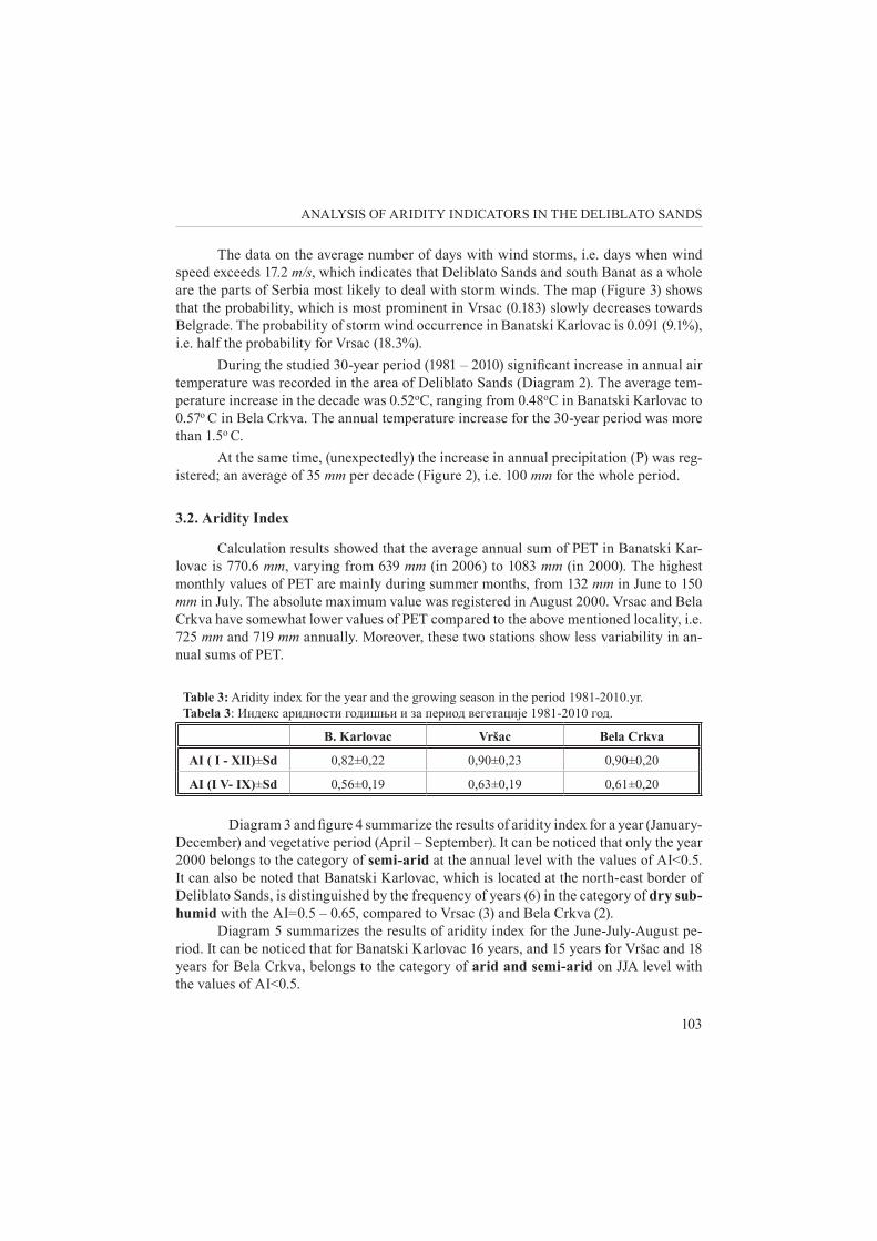
Table 3: Aridity index for the year and the growing season in the period 1981-2010.yr.Tabela 3: Индекс аридности годишњи и за период вегетације 1981-2010 год.
B. Karlovac Vršac Bela Crkva
AI ( I - XII)±Sd 0,82±0,22 0,90±0,23 0,90±0,20
AI (I V- IX)±Sd 0,56±0,19 0,63±0,19 0,61±0,20
Diagram 3 and figure 4 summarize the results of aridity index for a year (January- December) and vegetative period (April – September). It can be noticed that only the year 2000 belongs to the category of semi-arid at the annual level with the values of AI<0.5. It can also be noted that Banatski Karlovac, which is located at the north-east border of Deliblato Sands, is distinguished by the frequency of years (6) in the category of dry sub-humid with the AI=0.5 – 0.65, compared to Vrsac (3) and Bela Crkva (2).
Diagram 5 summarizes the results of aridity index for the June-July-August pe-riod. It can be noticed that for Banatski Karlovac 16 years, and 15 years for Vršac and 18 years for Bela Crkva, belongs to the category of arid and semi-arid on JJA level with the values of AI<0.5.

Kadović R., Spasov P., Ali Bohajar Y. M., Belanović Simić S., Košanin O.
104
Diagram 3. Aridity index series for the reference periods January-December in Banatski Karlovac, Vršac and Bela Crkva for the period 1981 – 2010
Графикон 3. Серије индекса аридности за референтни период од јануара до децембра у Банатском Карловцу, Вршцу и Белој Цркви за период 1981–2010
B. Karl.B. Cr.VrsacLinear (B. Cr.)Linear (Vrsac)Linear (B. Karl.)
Diagram 4. Aridity index series for the reference periods April- September in Banatski Karlovac, Vršac and Bela Crkva for the period 1981–2010
Графикон 4. Серије индекса аридности за референтни период од априла до септембра у Банатском Карловцу, Вршцу и Белој Цркви за период 1981–2010
B. Karl.B. Cr.VrsacLinear (B. Cr.)Linear (Vrsac)Linear (B. Karl.)

105
ANALYSIS OF ARIDITY INDICATORS IN THE DELIBLATO SANDS
Aridity index values for the summer months (JJA) at meteorological stations Banatski Karlovac, Vršac and Bela Crkva are shown in Table 4.
Table 4. Aridity index values for the summer monts June, July and August in Banatski Karlovac, Vršac and Bela Crkva for the period 1981 – 2010
Табела 4. Вредности индекса аридности у летњим месецима јуну, јулу и августу у Банатском Карловцу, Вршцу и Белој Цркви за период 1981 – 2010
B. Karlovac Vršac Bela Crkva
AI (VI)± Sd 0,7±0,34 0,73±0,42 0,70±0,39
AI (VII)± Sd 0,4±0,43 0,52±0,40 0,50±0,38
AI (VIII)± Sd 0,4±0,32 0,5±0,40 0,47±0,38
In relation to the number of years in which the aridity index lower than 0.5 (arid and semiarid) appeared, the situation is as follows: in June this value appeared for 13 years (Banatski Karlovac), 11 years (Vršac) and 9 years (Bela Crkva) in July - 21 years in (Banatski Karlovac), 20 years (Vršac) and 19 years (Bela Crkva), in the month of August - 19 years (Banatski Karlovac), 19 years (Vršac) and 21 years (Bela Crkva) .
Diagram 5. Aridity index series for the reference period JJA in Banatski Karlovac, Vršac and Bela Crkva for the period 1981–2010
Графикон 5. Серије индекса аридности за референтни период JJA у Банатском Карловцу, Вршцу и Белој Цркви за период 1981–2010
B. Karl.B. Cr.VrsacLinear (B. Cr.)Linear (Vrsac)Linear (B. Karl.)

Kadović R., Spasov P., Ali Bohajar Y. M., Belanović Simić S., Košanin O.
106
4. DISCUSSION
Precipitation is the most important climate factor in determining the areas which run the risk of soil degradation and potential desertification. Precipitation has the main role in the growth and spread of plant cover, but changeable and extreme precipitation can cause soil erosion and other adverse effects. It is observed in the area of Deliblato Sands that precipitation varies, both in monthly and annual intervals. The monthly and annual extremes could have significant negative influence on soil degradation in Deliblato Sands. The properties of precipitation disposition in Bela Crkva are almost completely consistent to the ones in Vršac.
The analysis of the number of days with extensive precipitation (more than 20 mm) showed that the area of south Banat, which includes Deliblato Sands, has somewhat more probability compared to central and north areas of Banat (Figure 2). However, the frequency of precipitation above 20 mm is considerably increased going from these low-lands towards west and south-west of Serbia. On the basis of the data on maximal pre-cipitation, the largest number of days with abundant precipitation is in the months of the vegetative period.
Apart from damages that could be caused by short term rainfalls of strong inten-sity (K a dov ić et al, 2013), wind impact is also an important factor of soil degradation in the sands. The effects of wind erosion and associated deposition include damage to soils through the loss of chemical fertility, the loss of soil depth, damage to crops and pastures through sandblasting and burial, damage to infrastructure by drift sand and dis-persion of weeds and diseases Fag h i h i n i a and A f z a l i (2013). According to the results of storm wind, it is a certain extent sufficient for Deliblato Sands because the less fre-quent storm wind in this part of Košava area the less unfavourable consequences caused by wind erosion.
The temperature of air and soil, apart from precipitation, is the main factor deter-mining the climate in all world regions as well as the distribution of plant cover on vari-ous soil types (WMO, 2005). Seasonal and daily changes in temperature and precipitation can influence soil humidity, biological activity, the speed of chemical reactions, the type of vegetation, and other. Soil degradation is increased in longer periods with insufficient precipitation, high temperatures, and strong winds because they contribute to drying of the surface soil layer and the loss of its structure (Z he ng hu et al., 2004, J i a et al., 2011). With all of the above, reviewing direct influence of temperature and precipitation to the process of degradation should be completed with the frequency of droughts of various durations (Li et al. 2009).
The increase in annual temperatures and precipitation in Deliblato Sands and wid-er, caused many stressful climate changes which had a negative influence on the process of soil degradation. Those increases primarily manifest in longer drought periods which lead to vegetative destruction and loss of biological and economic productivity in the re-gion, and wind and water erosions (extreme drought periods are usually followed by ex-cessive and strong precipitation which cause strong soil erosion).

107
ANALYSIS OF ARIDITY INDICATORS IN THE DELIBLATO SANDS
In order to determine the degree of aridity of Deliblato Sands climate, the balance between precipitation (as input) and evapotranspiration (as output) is particularly impor-tant. It is clear that the actual (AET) and not potential evapotranspiration (PЕТ) is the real output, but the adoption of AET could complicate the assessment of drought enor-mously (Ts a k i r i s G. and Va ngel i s H., 2005). Therefore PET can be selected as the key parameter representing the intensity of the atmosphere to absorb water from various ground surfaces, and PET is the basis of most actual evaporation estimations (M i l ly, 1992; Wa ng and D ick i n son , 2012). Consequently, the changes in PET due to climate change are likely to produce an effect on actual evaporation and more generally on the primary production of plants (Ba r e l l a - O r t i z et al, 2013).
As it was mentioned in the methodology, aridity index (AI) was defined as the ratio between annual precipitation (P) and potential evapotranspiration (РЕТ). It repre-sents the basis for defining the areas prone to the risk of soil degradation and potential desertification. There are different methods for assessing PET. The most complex ones are based on the energy balance equation and require a large amount of climate data such as Penman-Monteith equation (A l le n et al, 1998). Simpler methods usually require one or two meteorological elements (T hor n t hwa i t e , 1948; P r ie s t ly and Taylo r, 1972.; Ha rg r e ave s and A l le n , 2003).
The advantage of applying the Thornthwaite (1948) method is reflected in the fact that the potential evapotranspiration is determined only on the basis of average monthly air temperatures.
When monthly and annual sums of potential evapotranspiration are determined, the conditions are created for determining the aridity index (AI) which is the end prod-uct of this analysis. On the basis of the annual ratio between precipitation and potential evapotranspiration (Р/РЕТ), humid climate (AI>0.65) prevails in Deliblato Sands. How-ever, when aridity index for the warm half of the year is taken into consideration, the as-sessment of aridity is completely changed. The results of these assessments for the April – September period were given on the right hand side of figure 7. It is obvious that the number of seasons with semi-arid and dry sub-humid characteristics is considerably increased compared to the previous case scenario. Twelve out of 30 seasons in Banatski Karlovac were in the category of semi-arid, 12 were dry sub-humid, and 8 were humid; in Vrsac 11, 7, and 12; and in Bela Crkva 8, 12, and 10, respectively.
Summer months (Jun, July August) at studied meteorological stations appeared to be the predominant season with arid and semiarid characteristics.
5. CONCLUSION
The vulnerability of the special nature reserve Deliblato Sands to hydro-meteoro-logical disasters (excessive precipitation, floods, wind storms, droughts …) was analysed on the basis of climate factors which have the unfavourable influence to soil degradation
Kadović R., Spasov P., Ali Bohajar Y. M., Belanović Simić S., Košanin O.
108
processes and potential desertification. Aridity level of the climate in Sands was deter-mined by applying the available aridity index (AI) which is the ratio between annual (sea-son) precipitation (P) and potential evapotranspiration (РЕТ).
The results of researches performed for the last 30-year period (1981 – 2010), show an increase in annual air temperatures (Т) and annual precipitation sum (Р). The increas-es in annual temperatures and precipitation in Deliblato Sands and wider, caused numer-ous stressful climate changes which had negative influence on soil degradation processes.
Aridity index (АI), which is the end product of this analysis, showed that humid climate (АI>0.65) prevails in the area of Deliblato Sands. However, aridity changes com-pletely when the warm part of the year (April – September) is separately analysed. In a case like that, about 2/3 of seasons showed the following aridity categories: semi-arid and dry sub-humid, whereas 1/3 were humid. In summer months (Jun, July August) at the studied meteorological stations predominantly appeared the season with arid and semiarid properties.
It is necessary to emphasise that the Thornthwaite method compared to the Pen-man-Monteith, Hargreaves, Priestly-Taylor and other methods, usually shows lower val-ues of potential evapotranspiration. The application of the above mentioned methods will considerably reduce the ratio of annual precipitation and potential evapotranspiration (Р/РЕТ), i.e. aridity index (АI), which will show the increased aridity of Deliblato Sands climate for a larger number of years. On the other hand, as part of recently adopted En-ergy and Water Balance Monitoring System in Europe (Rose m a , A, de Wei rd t , M, Fop p e s , S.), on the basis of meteorological data obtained from the Metweosat satellite, PET is in accordance with the Penman-Monteith equation which was calculated as the product of net radiation (Rn) and number 0.8, i.e. РЕТ≈0.8Rn. Applying the equation in question to available Rn data for the Banatski Karlovac and Vrsac stations, the data on po-tential evapotranspiration were obtained and they were quite close to the results obtained by the Thornthwaite method.
REFERENCES
A l le n , R .G. , Pe r e i r a , L . S . , R a e s , D. A nd Sm i t h , M., 1998.. ”Crop evapotranspiration. Guidelines for computing crop water requirements”. Food and Agricultural Orga-nization of the United Nations (FAO) Irrigation and Drain, Paper No. 56. Rome, Italy. 24-47.
A nt i ć , M. , Avd a lov ić , V. , Jov ić , N. 1969. Evolution, Genetic Association and Ecological Value of Certain Deliblato Sands Types, Deliblato sand, book of papers I, Yugoslav agricultural and forest centre and SIK Pancevo, p. 47-66.
Ba r e l l a - O r t i z , A . , Polche r, J . , Tu z e t , A . , a nd K . L ava l , K., 2013. Potential evapora-tion estimation through an unstressed surface-energy balance and its sensitivity to climate change, Hydrol. Earth Syst. Sci., 17, 4625–4639, www.hydrol-earth-syst-sci.net/17/4625/2013/doi:10.5194/hess-17-4625-2013

109
ANALYSIS OF ARIDITY INDICATORS IN THE DELIBLATO SANDS
Fa g h i h i n i a , M. a nd A f z a l i , S. F., 2013. Effects of wind erosion on soil organic carbon dy-namics and other soil properties: Dejgah catchment, Farashband County, Shiraz Province, Iran. African Journal of Agricultural Research, Vol. 8 (34), pp 4452-4459, September, 2013, DOI:10.5897/AJAR12.2100
H a r g r e ave s , G. and A l le n , R. 2003. History and Evaluation of Hargreaves Evapotranspiration Equation. Journal of Irrigation and Drainage Engineering, Jsnuary-February /53.
J i a , Q. , K nu t s s on , S . , A l -A n s a r i , N. , Hu a ng , Y. (2011): Particle characterization and determination of erodible fraction of surface soil nearby the open pit in Malm-berget mine, Sweden, International Multidisciplinary Scientific GeoConference & EXPO: Modern Management of Mine Producing, Geology and Environmental Pro-tection, Varna, Bulgaria, 1 - 12.
Ko s t a d i nov, S . , Sp a s ov, P.: (2006): Indicators of Desertification in Serbia. BALWOIS, Con-ference of Water Observation and Information System for Decision Support, 23-26 May 2006, Ohrid, Republic of Macedonia, p.p.10, Full paper on CD
Ko š a n i n , O. 2001. The Role of Organic Matter in Morphological Evolution of Soil as Part of A-C Study in Deliblato Sands. Master Paper, Faculty of Forestry, Belgrade.
L i , F-R . , Z h a o , W-Z . , L iu , J -L . , Hu a ng , Z-G. (2009): Degraded vegetation and wind erosion influence soil carbon, nitrogen and phosphorus accumulation in sandy grasslands, Plant Soil (2009) 317:79–92, DOI 10.1007/s11104-008-9789-8
McKe e , T. , D o e ske n , N. , K le i s t , J. 1993. The Relationship of Drought Frequecy and Du-ration to Tie Scales. Eighth Conference on Applied Climatology.
P r ie s t ly, C .H . B. and Taylo r , R.J., 1972. On Assessment of Surface Heat and Evaporation us-ing large-scale Parameters. Monthly Weather Rev., 100(2), 81-92.
Ro s e m a , A . , We i r d t , M. , Fo p p e s , S. Meteosat based Agrometeorological Monitoring and Crop Yield Forecasting using the Energy and Water Balance Monitoring System. Netherlands.
T ho r n t hwa i t e , C. 1948. An approach towards a rational classification of climate. Geographi-cal Review: 38, 55-94.
Ts a k i r i s , G . a nd Va nge l i s , H., 2005. Establishing a Drought Index Incorporating Evapo-transpiration. European Water 9/10, 3-11.
UNCCD. 1995. United Nations Convention to Combat Desertification in those countries Experi-enced serious Drought or Desertification particularly in Africa.
UNEP. 1992. World Atlas of Desertification, Edvard Arnold, London. Vu le t a , A . , S . M. Jova nov ić , D. Še š l i j a and B. Tu c ić . 2009. Seasonal dynamics of foliar
antioxidative enzymes and total anthocyanins in natural populations of Iris pumila L. Journal of Plant Ecology. 3, 59-69.
WMO. 2005. Climate and Land Degradation, WMO-No. 989, World Meteorological Organization, Geneva, Switzerland, ISBN 92-63-10989-3, 34 pg.
Wa ng , K . a nd D ick i n s on , R. E.: A review of global terrestrial evapotranspiration: observa-tion, modeling, climatology, and climatic variability, Rev. Geophys., 50, RG2005, doi:10.1029/2011RG000373, 2012.
Z he ng hu D. , Hong l a ng , X . , X i n r ong , L . , Z h i b a o , D. , G a ng , W. (2004): Evolution of soil properties on stabilized sand in the Tengger Desert, China, Geomorfology 59, 237-146

Kadović R., Spasov P., Ali Bohajar Y. M., Belanović Simić S., Košanin O.
110
Ратко КадовићПетар СпасовYousef Mansour Ali BohajarСнежана Белановић СимићОливера Кошанин
АНАЛИЗА ИНДИКАТОРА АРИДНОСТИ НА ПОДРУЧЈУ ДЕЛИБЛАТСКЕ ПЕШЧАРЕ
РезимеАнализа годишњих температура у другој половини 20. века показала је, да је у већем
делу Србије регистрован пораст тепературе, који је био нарочито изражен у последње две деценије прошлог века (Sp a s ov et al., 2002). С друге стране, током поменутог 50-годишњег периода, евидентирано је опште смањење годишњих сума падавина широм територије Ре-публике (изузев у високим планинским областима западне Србије). Поменуте климатске промене, које се огледају у повећању температуре и смањењу падавина, доприносе стварању повољнијих услова за деградацију земљишта у нашим крајевима.
Резултати истраживања других фактора деградације земљишта и дезертификације, поред климатских параметара, показали су да коришћење земљишта у Војводини, која има само 6% шумског покривача, ствара повољне услове за развој јаких процеса ерозије ветром (Ko s t a d i nov S., Sp a s ov P., 2006.). Делиблатска пешчара је посебно угрожена овом поја-вом у једном делу године, када дувају јаки источни и југоисточни ветрови.
Екстремни услови станишта (едафски и климатски) и порекло шумских култура, ус-ловљавају нестабилност ових система. Као последица тога, слабе виталност и стабилност шумских екосистема, а штетни фактори се јављају у сукцесији и утичу на иреверзибилне токове њихове девастације и деградације.
Угроженост Специјалног резервата природе Делиблатска пешчара од хидромете-оролошких непогода (обилне падавине, поплаве, олујни ветрови, суше,...), анализирана је на бази климатских фактора који неповољно делују на процесе деградације земљишта и потенцијалне дезертификације. Степен аридности климе Пешчаре је оцењен применом по-знатог индекса аридности (АI), који приказује однос годишњих (сезонских) падавина (Р) и потенцијалне евапотранспиравије (РЕТ).
Резултати истраживања су извршена за последњи 30 годишњи период (1981-2010. година), у коме је регистрован значајан пораст годишње температуре ваздуха (Т) и го-дишњих сума падавина (Р). Поменуто повећање годишњих температура и падавина у Де-либлатској пешчари и шире, изазвале су бројне климатске стресне ситуације, које су непо-вољно утицале на процесе деградације земљишта.
Индекс аридности (АI), који представља финални резултат ове анализе, је показао да на подручју Делиблатске пешчаре преовлађује у глобалу влажан климат (АI>0.65). Међутим, услови аридности се у потпуности мењају када се посебно разматра топли део године (април – септембар). У том случају, око 2/3 сезона су попримиле категорије аридно-сти: полу-сушно и мало влажно, а једна трећина влажно. У летњим месецима (јун, јул август), индекс аридности показује да подручје Делиблатске пешчаре припада, претежно, аридној и семиаридној зони.
Потребно је нагласити да метод Thornthwaite, у односу на методе Penman-Monteith, Hargreaves, Priestly-Taylor и др., углавном даје мање вредности потенцијалне

111
ANALYSIS OF ARIDITY INDICATORS IN THE DELIBLATO SANDS
евапотранспирације. Примена резултата поменутих метода у приличној мери ће смањити однос годишњих падавина и потенцијалне евапотранспирације (Р/РЕТ), односно индекс аридности (АI), што ће у већем броју година указивати на повећану аридност климе Делиблатске пешчаре. С дуге стране, у оквиру недавно успостављеног Система мониторинга енергетског и водног биланса у Европи (Ro s e m a , A., d e We i r d t , M., Fo p p e s , S.,), на бази метеоролошких података добијених помоћу сателита Meteosat, РЕТ је у сагласности са једначином Penman-Monteith рачуната као производ нето зрачења (Rn) и броја 0.8, тј. РЕТ≈0.8Rn. Применом поменуте једначине на расположивим подацима Rn за станице Банатски Карловац и Вршац добијени су подаци о потенцијалној евапотранспирацији који се у великој мери подударају са резултатима добијених методом Thornthwaite.
Kadović R., Spasov P., Ali Bohajar Y. M., Belanović Simić S., Košanin O.
112