analysis of landforms in geoarchaeology: campo lameiro… · project on the future rock art park of...
TRANSCRIPT

ABSTRACT – The present work is part of an interdisciplinaryproject on the future Rock Art Park of Campo Lameiro(Galicia, NW Spain), in which Earth Science disciplinesplayed a fundamental role in the development of the ar-chaeological project. Our investigation focused on the evo-lution of landforms as a key factor in geoarchaeologicalanalysis. The aim was to determine the influence and controlof relief structure on the formation, distribution and gene-sis of soils and sediments in Campo Lameiro –which maybe considered as the environmental archives. This approachis particularly important in this area, due to the scarcity of ar-chaeological remains other than the rock art itself. Soils andsediments are unique archives that have recorded landscapetransformations linked to cultural evolution. In the studiedarea the oldest sedimentary facies date back to the late Pleis-tocene – early Holocene. From the mid Holocene onwardsthe dominant processes are erosion and colluviation, in highand low potential energy areas respectively; which impliedan intense redistribution of the soil resource through time.During the Bronze Age, when most rock art panels appearto have been made, these processes intensified and the rocksurfaces were largely exposed. The environmental dynamicsin the area follows a pattern already described for other sec-tors of NW Spain, and is therefore consistent with the re-gional evolution. Our results demonstrate the usefulness ofpaleoenvironmental analyses in building a framework for thecomprehension of Galician rock art.
KEY WORDS: Geoarchaeology, Landforms, Environmentalarchives, Late Pleistocene, Holocene.
RIASSUNTO – Il presente lavoro è parte di un progetto inter-disciplinare sul futuro Parco dell’arte rupestre di Campo La-meiro (Galizia, nord-ovest della Spagna), dove le disciplinedelle Scienze della Terra giocano un ruolo fondamentalenello sviluppo del progetto archeologico. Le ricerche svilup-
pate si sono concentrate sull’evoluzione delle forme del ri-lievo come fattore chiave nelle analisi geoarcheologiche. Loscopo è stato quello di determinare l’influenza e il controllodei fattori strutturali del rilievo nella formazione, distribu-zione e genesi dei suoli e dei sedimenti in Campo Lameiro,che può essere considerato un archivio ambientale. Questoapproccio di lavoro è particolarmente efficace ed importantein quest’area, a causa della scarsità di ritrovamenti archeolo-gici diversi da quelli legati all’arte rupestre. Suoli e sedimentisono archivi unici in cui sono registrate le trasformazioni delpaesaggio collegate all’evoluzione culturale. Nell’area di stu-dio la più antica facies sedimentaria risale al tardo Pleisto-cene – inizio Eocene. Dal medio Olocene in avanti i processidominanti sono l’erosione e la produzione di colluvio, ri-spettivamente in aree ad alta e bassa energia potenziale. Que-sto implica un’intensa ridistribuzione della risorsa suolo neltempo. Durante l’Età del Bronzo, quando la maggior partedelle pitture rupestri sembra siano state fatte, questi processisi intensificarono e le superfici rocciose furono ampiamenteesposte. Le dinamiche ambientali nell’area seguono unoschema già descritto per altri settori della Spagna nord-occi-dentale e quindi conforme con l’evoluzione regionale. I ri-sultati qui illustrati dimostrano l’utilità delle analisipaleoambientali per la comprensione dell’arte rupestre dellaGalizia.
PAROLE CHIAVE: Geoarcheologia, Forme del rilievo, Archiviambientali, Tardo Pleistocene, Olocene.
1. - INTRODUCTION
Geoarchaeology is both an interdisciplinary andspecialized discipline. This dichotomy does notweaken the discipline, although it does lead to de-
Analysis of landforms in geoarchaeology: Campo Lameiro, NW Iberian PeninsulaAnalisi delle forme del rilievo in geoarcheologia: Campo Lameiro, Penisola Iberica nord-occidentale
(*) The Heritage Laboratory. IEGPS-CSIC, Santiago de Compostela, Spain – Email: [email protected](**) Heritage, Paleoenvironment and Landscape Laboratory. USC-CSIC, Santiago de Compostela, Spain
COSTA CASAIS M. (*), MARTÍNEZ-CORTIZAS A. (**), PONTEVEDRA-POMBAL X. (**),
CRIADO-BOADO F. (*)
Mem. Descr. Carta Geol. d’It.LXXXVII (2009), pp. 39-52
figg. 12 - tabb. 2

bates over its boundaries and definitions (HUCK-LEBERRY, 2000). BUTZER (1971, 1981, 1982) wasamong the first to stress the application of a geo-scientific perspective in the study of human pre-history, a field that he defined at the time asprehistoric geography. In his view, humans are bestunderstood with respect to their ecology, andGeoarchaeology could play an important role indefining the environmental context of past soci-eties. He also alluded to the significance of suchresearch to modern environmental issues. HUCK-LEBERRY (2000) defined Geoarchaeology, slightlymodifying the perspective offered by GIFFORD &RAPP (1985), as “the application of Earth Sciencemethod and theory to understanding the humanpast.” This definition is broad enough to includeexperts from a range of scientific backgrounds tocontribute towards the understanding of humanprehistory. The archaeological record is a complexsystem affected by a variety of chemical, physicaland biological processes, that have to be definedprior to deciphering behaviour through induction.All of these theoretical considerations, and a grow-ing recognition of the value of interdisciplinarystudy, have made it possible for Geoarchaeologyto become an essential component in archaeolog-ical projects (MARTÍNEZ CORTIZAS, 2000).
Regardless of the nature and rate of humandisturbance on the landscape, considerable debatehas surrounded the identification of climatechanges and human impacts (whether direct or in-direct) as driving forces of landscape change. As-sessments of the geomorphic impacts of humanmodification to landscapes must be framed withinthe context of the natural range of variation, re-quiring solid baseline information on the long-term character and behaviour of the system inquestion (BRIERLEY & STANKOVIANSKY, 2002). Re-lief structure and its evolution govern the forma-tion, erosion and distribution of soil andsediments. Due to the difficulties in direct datingof the panels, in rock art sites it is necessary to un-veil the chronology of the processes of weather-ing, erosion and sedimentation to know when theexhumation of the rock outcrops occurred, andthus rock art could have been produced.
On the other hand, the distribution of archae-ological sites is a function of several factors: cul-tural activities, taphonomic processes, geomorphicchanges, and the nature and extent of the archae-ological surveys themselves (SCHIFFER, 1987; Stein,2001). The distribution of archaeological sites de-tected using GIS reflects patterns of discovery anddocumentation, which in turn are influenced bysurvey strategies such as the distribution of rockart, and geomorphic processes -erosion and dep-
osition of sediments (BAUER et alii, 2004; GUC-CIONE et alii, 1998). Also, the concept of landscapesensitivity is fundamental to the relationship be-tween climate and erosion in shaping the land-scape. According to KNOX (2001) “Agriculturallandscapes are more sensitive to climatic variabil-ity than natural ones because tillage and grazingtypically reduce water infiltration and increase ratesand magnitudes of surface runoff.” The effect oferosive rainfall can be amplified because bare soilaccelerates surface runoff and soil erosion. Stud-ies developed in NW Spain support the interpre-tation that human activities in the past led to arapid decrease of forest cover and accelerated soilerosion, challenging the ability of cultures to adaptto new circumstances (GONZÁLEZ DÍEZ et alii,1996; MARTÍNEZ CORTIZAS et alii, 2005).
The work presented here is part of an interdis-ciplinary study on the area where the future RockArt Park of Campo Lameiro (Galicia, NW Spain)will be located. In this project Earth Sciences dis-ciplines played a major role in complementing thearchaeological research. Our paper focuses on theevolution of landforms -rocky substrate, sedi-ments and soils - as a key factor for geoarchaeo-logical analysis, with the objective of defining therelief units –location and timing of formation- andto relate them to the spatial distribution of therock carvings. We aim to determine the influenceand control of relief structure on the formation,distribution and evolution of soils and sediments.
This approach is particularly important in thestudied area since there are few archaeological re-mains other than the rock art itself. Granite land-forms, soils and sediments are unique archives thathave recorded transformations in the landscapelinked to cultural evolution.
2. – STUDY AREA AND METHODOLOGY
The future Campo Lameiro Rock Art Park isbeing built in southwestern Galicia (NW Spain) atan elevation of 330 m a.s.l. and 25 km from thecoast (fig. 1). The area is an almost isolated hill,isolated by a series of fractures with preferentialdirections (N-S, E-W), which the fluvial networkuses to flow through the territory. The generalrolling topography, with a series of tops andtroughs, is the result of a combination of graniticmacro and microforms. It is an area of transitionbetween the coast and mountain range withhumid, temperate climate. Present mean annualtemperature is 14.5 °C, and mean annual precipi-tation is 1500 mm (MARTÍNEZ CORTIZAS & PÉREZALBERTI, 1999).
40 COSTA CASAIS M. - MARTÌNEZ CORTIZAS A. - PONTEVEDRA POMBAL X. - CRIADO BOARO F.

The methodology used to relate the geoar-chaeological analyses and the geomorphologiccontext started with the interpretation of aerialphotographs, in order to define the relief units andhow they link to the regional geomorphologic con-text. In a second stage, fieldwork was carried outin order to differentiate landforms. All this infor-mation was used as a basis in order to designingand subsequent opening of 43 ditches in ten sec-tors, with a total length of 2.5 km (fig. 2). We fol-lowed two main criteria for its design: the varietyof morphological units, their location in sectorsprone for accumulation, in erosive/accumulativeor erosive areas; and their proximity to the rockcarvings. The aim was to obtain as extensive andvaried a representation as possible of the superfi-cial formations that fossilize the substrate, their fa-cies and morpho-sedimentary features, and toobtain as full a stratigraphic sequence as possible.
The groups of ditches correspond to different mi-crotopographies, each associated to rock carvings. Sys-tematic descriptions of the sedimentary facies weremade in order to define the vertical and lateral strati-graphic changes. More detailed descriptions weremade for a small number of profiles in each ditch,which generally coincided with the deepest ones andshowing the greatest variation of sedimentary facies.
Eleven deep soil profiles (with depths between1,5 and 3 m) were also selected for more completegeochemical soil analyses -such as the concentra-tion of trace elements- and pollen analyses: five
representative of different sectors of the area, fivein a transept perpendicular to one of the most im-portant rock art panels, and one outside of thePark area. The locations of the trenches, the soilprofiles and the rock art panels were incorporatedinto a digital terrain model, then combined withthe information obtained from the other disci-plines involved –Geomorphology, Archaeologyand Pedology– to conform a GIS database (fig. 2).
3. – RESULTS
3.1. – GEOLOGICAL STRUCTURE AND BEDROCKLITHOLOGY
The sector of Campo Lameiro was subjectedto the lithostructural evolution of the northwest-ern Iberian Peninsula. The tectonic movementsthat occurred throughout the geological history ofGalicia acted differentially on its lithology, and de-fined the main lines of the relief at regional andlocal scales (PARGA PONDAL, 1969; PÉREZ AL-BERTI, 1986; 1990; 1993). The result was the for-
41ANALYSIS OF LANDFORMS IN GEOARCHAEOLOGY: CAMPO LAMEIRO, NW IBERIAN PENINSULA
Fig. 1 – The future Campo Lameiro Rock Art Park will be located in South-Western Galicia (NW Spain) at an elevation of 330 m a.s.l. and 25 km from
the Atlantic coast.– Il futuro Parco dell’arte rupestre di Campo Lameriro sarà ubicato nel settore sud-oc-cidentale della Galizia (Spagna NW) a 330 m s.l.m di quota e a 25 km dalla costa
atlantica.
Fig. 2 – The georeferenced trenches, soil profiles and rock art panels geo-referenced, were incorporated into a digital terrain model, then combinedwith the information obtained from the other disciplines involved – geo-
morphology, archaeology and pedology– to conform a GIS database.– Le trincee georeferenziate, i profili pedologici e le pitture rupestri georeferenziate sonostate aggiunti in un modello digitale del terreno e successivamente implementati con le in-formazioni geomorfologiche, archeologiche e pedologiche per costruire un database
cartografico.
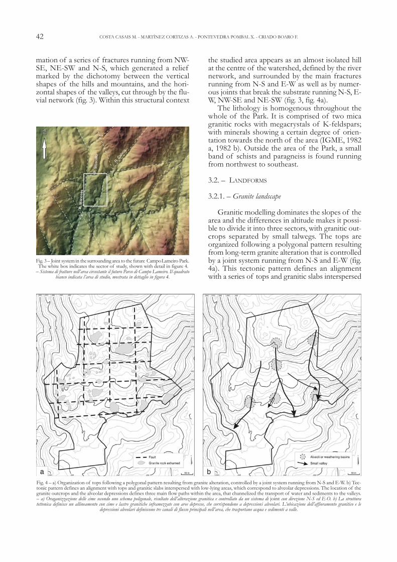
mation of a series of fractures running from NW-SE, NE-SW and N-S, which generated a reliefmarked by the dichotomy between the verticalshapes of the hills and mountains, and the hori-zontal shapes of the valleys, cut through by the flu-vial network (fig. 3). Within this structural context
the studied area appears as an almost isolated hillat the centre of the watershed, defined by the rivernetwork, and surrounded by the main fracturesrunning from N-S and E-W as well as by numer-ous joints that break the substrate running N-S, E-W, NW-SE and NE-SW (fig. 3, fig. 4a).
The lithology is homogenous throughout thewhole of the Park. It is comprised of two micagranitic rocks with megacrystals of K-feldspars;with minerals showing a certain degree of orien-tation towards the north of the area (IGME, 1982a, 1982 b). Outside the area of the Park, a smallband of schists and paragneiss is found runningfrom northwest to southeast.
3.2. – LANDFORMS
3.2.1. – Granite landscape
Granitic modelling dominates the slopes of thearea and the differences in altitude makes it possi-ble to divide it into three sectors, with granitic out-crops separated by small talwegs. The tops areorganized following a polygonal pattern resultingfrom long-term granite alteration that is controlledby a joint system running from N-S and E-W (fig.4a). This tectonic pattern defines an alignmentwith a series of tops and granitic slabs interspersed
42 COSTA CASAIS M. - MARTÌNEZ CORTIZAS A. - PONTEVEDRA POMBAL X. - CRIADO BOARO F.
Fig. 4 – a) Organization of tops following a polygonal pattern resulting from granite alteration, controlled by a joint system running from N-S and E-W. b) Tec-tonic pattern defines an alignment with tops and granitic slabs interspersed with low-lying areas, which correspond to alveolar depressions. The location of thegranite outcrops and the alveolar depressions defines three main flow paths within the area, that channelized the transport of water and sediments to the valleys.– a) Oraganizzazione delle cime secondo uno schema poligonale, risultato dell’alterazione granitica e controllato da un sistema di joint con direzione N-S ed E-O. b) La struttura tettonica definisce un allineamento con cime e lastre granitiche inframezzate con aree depresse, che corrispondono a depressioni alveolari. L’ubicazione dell’affioramento granitico e le
depressioni alveolari definiscono tre canali di flusso principali nell’area, che trasportano acqua e sedimenti a valle.
Fig. 3 – Joint system in the surrounding area to the future CampoLameiro Park.The white box indicates the sector of study, shown with detail in figure 4.
– Sistema di fratture nell’area circostante il futuro Parco di Campo Lameiro. Il quadrato bianco indicata l’area di studio, mostrata in dettaglio in figura 4.

with small low-lying areas, which correspond toalveolar depressions (fig. 4b).
The central sector of the area has a maximumelevation of 330 m a.s.l. and minimum one of 259m a.s.l. Altitude decreases from north to south ina series of steps, with Devesa do Cura and Corvotops to the north, at a elevations over 300 m a.s.l.,to a central peak, Ferreiriña, at 289 m a.s.l., and tothe south, Outeiro Grande, at 250 m a.s.l. (fig. 2).
The upper and lower sectors are connectedthrough steep, deeply eroded slopes, where therock substratum is visible at the surface -as it hap-pens in the slopes facing towards the east of thePark. This sector is contrasting with the centraland western ones, where the main shape is artic-ulated into three levels with different altitudes andgentler slopes, dominated by alveolar depressionssurrounded by crests and granitic slabs.
The lithological, structural and geomorphologicalvariety found corresponds to that of granitic land-forms (tab. 1). The latter are classified into two groups,depending on their size: megaforms or large scaleforms, and microforms or smaller forms (GODARD,1977; TWIDALE, 1986; 1989). The most importantwithin the first group are convex megaforms, mostlygranitic crests, represented by castle kopjes (fig. 5) inwhich vertical joints predominate over horizontaljoints, such as those were the petroglyphs of As Ven-taniñas and As Forneiriñas are located; or tors, in which themain joints run horizontally, such as Pena Furada (fig. 6).
Recent stone quarrying works on the crests hasconsiderably modified their initial structure, mak-ing it difficult to find them with their natural shape.As a whole they are combined with concavemegaforms – depressions or alteration alveoli – whichoccupy a lower topographic position, and are sur-rounded by granitic tops (fig. 7).
At an intermediate topographic position are thegranitic slabs, minor forms that are related to thestructure of the rock - joints direction mainly -,flat in shape and slightly tilt down. They are asso-ciated with other smaller linear forms not relatedto the rock structure and usually located on verti-cal surfaces as grooves and channels, with small de-pressions as gnamas –found both on horizontal andvertical walls. But also to other small linear micro-forms related to rock structure, as narrow chan-
43ANALYSIS OF LANDFORMS IN GEOARCHAEOLOGY: CAMPO LAMEIRO, NW IBERIAN PENINSULA
Fig. 5 – Dismantled castle kopje in the upper part of Campo Lameiro. Insome cases fallen blocks contain rock carving.
– Kopje smantellata nella parte superiore di Campo Lameiro. In alcuni casi i blocchi caduti contengono delle incisioni rupestri.
Fig. 6 – Tor of Pena Furada. The main joints run horizontally. There arerock carvings on the horizontal surfaces both on the basal rock and higher
surfaces. – Tor della Pena Furada. I joints principali si sviluppano orizzontalmente. Vi sono incisioni rupestri sulle superfici orizzonatli sia nella parte basale che in quella superiore.
Tab. 1 – The lithological, structural and geomorphologicalvariely of granite landscape. Types of megaforms and microforms in Campo Lameiro, modified from
TWIDALE (1992).- La varietà litologica, strutturale e geomorfolo-
gica del paesaggio granitico. Tipi di megaforme emicroforme in Campo Lameiro, modificato da
TWIDALE (1992).GRANITE LANDSCAPE IN CAMPO LAMEIRO
MEGAFORMS
CONVEX FORMS CONCAVE FORMS
Mountain ridges
Castle-kopje
Tor
Block
Alveoli or weathering basins
MICROFORMS
MICROFORMS without any evident relationship to the rock structure
Linear forms
Gutters
Pointed forms
Gnammas
Tafone
MICROFORMS without any evident relationship to the rock structure
Linear forms
Polygonal craking
Nerviate forms
Flat forms
Brocken blocks

nels and cracks, which follow the direction of jointsor the areas between the planes of a joint. Therock art panels of Os Carballos and Os Cogoludos aregood examples, carved on slabs, in which thejoints, narrow channels and other linear featuresare the result differential erosion (fig. 8).
Within the smaller forms are specific shapesthat are not related to rock structure: as gnamas and
taffonis. They are associated with megaforms andmainly found on tops and slabs. The first are con-cave in shape, and appear both on horizontal andvertical surfaces, whereas the second appear in theinner part of a wall producing a hollow structure-as in the tor of Pena Furada (fig. 9). In other casesgnamas at both sides of a rock connect to create ahole, as seen at the top of Ventaniñas (fig. 10).
3.2.2. – Sedimentary deposits
The thickest sedimentary deposits with thegreatest variety of stratigraphic layers are preferen-tially found in the alveolar depressions, where sed-imentation was favoured, and their paleoform hasconditioned the evolution of these surface forma-tions over time. Nevertheless, depending on wherethey are located surperficial formations can be clas-sified into four main groups: those situated in highpotential energy areas prone both to erosion andsedimentation, such as the one represented by thesequence of PRD-I (fig. 2, fig. 11a); those in lowenergy areas where accumulation dominated, suchas the channelled depressions where PRD-III (fig.11a) and PRD-V (fig. 11b) are found; formationsthat fossilize alveoli found at intermediate posi-
44 COSTA CASAIS M. - MARTÌNEZ CORTIZAS A. - PONTEVEDRA POMBAL X. - CRIADO BOARO F.
Fig. 9 – Tafoni of Pena Furada. It appears in the inner part of a wall producing a hollow structure.
– Tafoni a Pena Furada, presenti nella parte superiore di un muro, producono una struttura con caratteristiche conche.
Fig. 10 – Gnamma located in Ventaniñas. Gnammas are concave in shape,and appear both in horizontal and vertical surfaces.
– Depressioni a conca (gnammas) ubicate in Ventaniñas. I gnammas hanno forma concava e compaiono sia nelle superfici verticali che orizzontali.
Fig. 8 – Slab with joints, splits and linear branches. The rock surface is covered by rock carvings - cup marks and rings.
– Lastra con fratture, fessure e ramificazioni lineari. La superifcie della roccia è ricopertada incisioni, coppelle ed anelli.
Fig. 7 – Dismantled castle kopjes between alveoli or weathering depression.In the front there are rock carvings represented by cup marks and rings. – Kopje smantellata tra alveoli o depressioni legate all’alterazione meteorica. Di fronte
vi sono incisioni rappresentate da coppelle ed anelli.

45ANALYSIS OF LANDFORMS IN GEOARCHAEOLOGY: CAMPO LAMEIRO, NW IBERIAN PENINSULA
Fig. 11 – Sedimentological and stratigraphic columns: a) profiles PRD-I, II, III; b) profiles PRD-IV, IVa, V and a legend. – Colonne sedimentologiche e stratigrafiche: a) profili PRD-I, II, III; b) profili PRD-IV, IVa, V e la legenda.
b
a

tions, located next to the base of a granite slab andwith their external border eroded, as is the case ofPRD-II; and those that fossilize alveoli floors, as isthe case of PRD-IV, PRD-IVa (fig. 11b).
We do not make here a detailed description ofeach deposit, but provide a general summary ofthe most important morphosedimentary features(fig. 11a,b). Two types of stratigraphic units havebeen found: a basal inorganic sedimentary layerthat covers the granitic substrate with varyingthickness (50 to 100 cm); and a younger, thickerlayer (up to 250 cm) represented by colluvial, poly-cyclic soils, rich in organic matter.
The basal unit appears over the rock or a deeplyweathered saprolite, and is compossed of gravel andfaceted stones with rounded edges, mostly quartzwith some granite, embeded in a matrix of mediumto coarse sands with abundant muscovite and usuallywithout a clear sedimentary structure. This unit iswell represented in the PRD-IVa deposit (fig. 11b),which has one of the most complete stratigraphicsequences due to its topographic position. It con-tains layers of gravels and faceted stones interspersedwith a sandy matrix without any structure, accumu-lations of faceted gravels in cross beds and layers ofsubrounded quartz sands alternating with silt layers,in a lenticular shape. Iron coatings and discrete ironlayers are also frequent.
The second unit is represented by colluvial soilsthat show an apparent homogeneous morphologyresembling deep, black to dark brown A horizons(mineral soil rich in organic matter). They have aloamy sand to sandy loam texture, with abundantquartz and muscovite, are acidic and have highC/N ratios. Despite the apparent homogeneity inthe morphology, they contain gravel and stonelines at different depths, charcoal layers and layersof burnt soil of typical red to orange colour, as itcan be observed in figure 11 a, b.
4. – DISCUSSION
4.1. – GRANITE LANDSCAPE
Granite modelling is the result of the interac-tion of a number of factors: rock type, tectonic,climatic changes, human activities and the associ-ated morphogenetic systems, which either directlyor indirectly have acted over time, and led to thepresent shapes seen in Campo Lameiro (fig. 12).
The dense joint system helped to weaken thegranite and allowed alteration and weathering toproceed deeply into the rock. These processeswere enhanced during periods of favourable cli-matic conditions, such as the tropical climate thatprevailed in NW Spain during the Tertiary (PÉREZ
ALBERTI, 1986). Under these wet and warm cli-mate conditions the weathering of the granite pro-gressed faster generating a deep mantle ofsaprolite. At the same time the granitic macro andmicroforms were predefined and later exhumatedby the removal of the saprolite mantle througherosion and transport.
Alveolar depressions are the most representa-tive major forms found in Campo Lameiro. Theirformation was also controlled by the joint systemthat channelled both the upwards and downwardsalteration processes (hydrothermal/thermal) andthe downwards weathering processes (illuviationand other pedogenetic processes) (VIDAL ROMANÍ,1989). Their final shape is also linked to fluvial andalluvial processes that gradually uncovered themegaform.
The genesis of the more localized, small scalegranite forms occurred in many different waysthrough time. But most of them are the resultof the presence discontinuity planes thatfavoured uneven advances of the chemical andphysical alteration/weathering processes (disso-lution, exfoliation, humectation-dessication andhaloclastism) as well as formative features causedby concentrated loads in particular sectors of thegranite body that would predetermine the exis-tence of weak areas well before exhumantion(TWIDALE, 1989).
4.2. – SEDIMENTARY DEPOSITS
Present landscape in Campo Lameiro integrates and reflects the interactions of environmental fac-tors and human activity over time. This dynamic
46 COSTA CASAIS M. - MARTÌNEZ CORTIZAS A. - PONTEVEDRA POMBAL X. - CRIADO BOARO F.
Fig. 12 – The present landforms of relief are the result of different parameters: rock, tectonic, climatic conditions, time and anthropic action. – Le forme del rilievo attualmente presenti sono funzione di differenti parametri:
litologia, tettonica, condizioni climatiche, tempo e attività antropica.

evolution has been constant from the Late Pleis-tocene until today, as has been revealed by thepalaeoenvironmental records analyzed and the chro-nology supported by radiocarbon datings (tab. 2).Microtopography controlled erosion and sedi-mentation, the first being most acute in the steep-est slopes and at the foot of the tops, while theredistributed soils and sediments accumulated inthe talwegs and the alveolar depressions. Theshape of the studied area, a small isolated moun-tain with heights decreasing north to south, en-sures that all sediments have an internal source andthere was not significant contributions from theoutside. The location of the granite outcrops andthe alveolar depressions defines the existence ofthree main flow paths (fig. 4b) within the area,which served to channel the transport of waterand sediments to Praderrei and Paredes valleys.Part of it was not carried away, but was instead cap-tured and accumulated in the alveolar depressions.
The influence and control of the relief struc-ture is a determining factor in the formation, dis-tribution and evolution of the soils and sediments.Due to the lack of significant archaeological re-mains apart from the rock carvings, colluvial soilsare the only environmental archives that preservedthe record of the past changes. Colluvial soils arestratigraphically complex, differ in maximum ageand phases represented, and have signficant timehiatuses (as for example PRD-I, see table 2).
Radiocarbon dating and stratigraphic correla-tion helped to put into context the natural andhuman induced changes that took place in CampoLameiro since the late Pleistocene/beginning ofHolocene. These are comparable to those occur-red in other areas of the northwest of the Iberian
Peninsula and the Atlantic coast of Europe duringthe same period, although some specific morpho-sedimentary features are related to local evolution. One of the most outstanding features provided bythe morphology of the sediments is the sequenceof colluvial levels, with charcoal, stone and gravellayers as well evidence of soil burning. This burntsoils would be a consequence of both natural andhuman provoked fires. All these features point tointense soil erosion, either as a result of environ-mental factors, human activity or a combinationof both, as has been described for other parts ofEurope (SARMAJA-KORJONEN, 1992). Geomor-phology, stratigraphy and chronology provided thebasis to reconstruct landscape evolution in thearea, which can be described in four main phases.
-- Phase 1:11.000-8000 BPThe inorganic facies that evenly cover part of therock substrate and that preserved the sedimentarystructure in some places (such as PRD-IVa, figure11b), is the result of the erosion and transport ofthe strongly weathered saprolite mantle, whichgenerated a large amount of material. The miner-alogical composition, shape of the clasts, degreeof weathering and the type of fine matrix refersto a morphogenetic system controlled by water.This colluvio-alluvial formation is probably the re-sult of the erosion of more ancient deposits. Itssedimentary facies are quite varied. There are het-erogeneous and chaotic layers, resulting form soilflow processes; cross-bed, linear structures andlenticular sand layers, related with alluvial trans-port, which are only preserved in alveoli bottoms.They were formed under an alluvial morpho-genetic system, probably as small alluvial fans, withthree main channels following the natural talwegs.
47ANALYSIS OF LANDFORMS IN GEOARCHAEOLOGY: CAMPO LAMEIRO, NW IBERIAN PENINSULA
Tab. 2 – Bulk radiocarbon (14 C yr BP) and calibrated ages (1σ and 2σ) for different depths in two colluvial soils (PRD-I and PRD-II).
- Datazioni al radiocarbonio (14 C yr BP) ed età calibrate (1σ e 2σ) per differenti profondità in due de-positi colluviali (PRD-I e PRD-II).
Samplecode
Depth(cm)
Convetionalage
BP
Calibrate age
1σBP
Calibrate age
2σBP
Laboratory
PRD-I-11PRD-I-15PRD-I-19PRD-I-25
PRD-II-18PRD-II-25PRD-II-35PRD-II-39
50-5570-7590-95
120-125
85-90120-125170-175190-195
2300±403055±405300±507610±55
1835±403055±403770±405350±40
2350-2310 BP3340-3280 BP6065-5995 BP8430-8355 BP
1720-1820 BP3240-3340 BP4090-4160 BP6020-6080 BP
2360-2300 BP3360-3160 BP6200-5935 BP8485-8330 BP
1695-1870 BP3160-3360BP4060-4255 BP5995-6155 BP
Ua-21845Ua-21846Ua-21847Ua-21848
Ua-22555Ua-22556Ua-22557Ua-22558

The deepest deposit is associated with the ancienttrough that runs through the eastern sector of thearea from north to south. Fans are dynamic systems that can temporarilystorage sediments (GÓMEZ VILLAR, 1996) as a re-sult of a sporadic yet continuous supply, in geo-logical terms, in a highly energetic environment.Slope angle, the ability to concentrate runnoff, theheterometry of the sediments and a low vegeta-tion cover are all factors that help to explain thepresence of this kind of formations. A decreasingslope angle and the widening of the valley de-creases the energy of the runoff waters andfavours the dispersion of sediments in an orderlymanner. Alluvial fans depend equally on rainfalltorrentiality and the ability to produce largeamounts of sediments. At PRD-I (fig. 11a) thisbasal unit is fossilized by a paleosol that provideda radiocarbon age dating of 8,480-8,320 cal. BP,indicating that the fans are at least late Pleistoceneor early Holocene in origin. Their formation in thestudied area may be associated to the YoungerDryas (11.000-10.000 BP) which was characterizedby a severe cooling and rainy environment, as isrepresented at sedimentary level by important al-luvial-colluvial accumulations that are well definedin the northwestern Iberian Peninsula (MARTÍNEZCORTIZAS & MOARES DOMÍNGUEZ, 1995; VAL-CÁRCEL DÍAZ, 1998). This is consistent with recentresearch on fluvial activity in Spain that suggestsincrease activity by 11.170-10.230 and 9.630-8.785BP (THORNDYCRAFT & BENITO, 2006).
-- Phase 2: 8000-6000 BPFrom 8,480-8,320 cal. BP to 6,200-5,930 cal. BP(age obtained at the top of second paleosol ofPRD-I), sedimentation must have slowed and pe-dogenesis progressed due to landscape stabilityand large vegetation cover. Although not detectedin Campo Lameiro, the earliest evidence of signi-ficant transformations by humans in NW Iberiadate back to this period, around 7500-7000 BP(during the Epipaleolithic), and seem to have beenthe result of small scale impacts in the forest bymeans of fires (MARTÍNEZ CORTIZAS, 2000;MARTÍNEZ CORTIZAS et alii, 1999 a,b, 2000).
-- Phase 3: 6000-3500 BPThe second paleosol of PRD-I shows an abruptdiscontinuity with the overlying layer –a stone line-suggesting the onset of intense soil erosion. Con-sidering the available radiocarbon dating this mayhave happen after 6200-5930 cal BP, an age corre-lated to the initiation of sedimentation in PRD-IIwith a basal radiocarbon dating of 6155-5990 calBP. As a result of increased erosion the transportof soil and sediments caused a progressive accre-tion and infilling of the alveolar depressions and
the valleys of Praderrei and Paredes. It was possi-bly at this time, around 6000 BP (the Mid Ne-olithic), when the granite outcrops started to beexhumed together with the upper part of the slabs.Studies on landscape evolution in northwesternSpain indicate that soil erosion began to be a wide-spread phenomenon at least from 6,000-5,500 BP(COSTA et alii, 1996; MARTÍNEZ CORTIZAS, 2000;MARTÍNEZ CORTIZAS et alii, 2000). A decline in fo-rest cover and the first appearance of cereal polenindicated by palynological studies (RAMIL, 1993;MARTÍNEZ CORTIZAS et alii, 2005), the erosive dis-continuities, stone and charcoal lines in colluvialsoils, as well as the start of a progressive soil aci-dification point to human activities as the maintrigger. But this is also coincident with a climaticabrupt change in Spain and other parts of Europe(MARTÍNEZ CORTIZAS et alii, 1999 b,c; MAGNY etalii, 2006) to wetter and cooler conditions, whichprobabily resulted in a higher landscape sensitivityto human activities.
-- Phase 4. 3500- 500 BPA relative stability of the slopes seems to have oc-curred at the beginning of this period, shown bythe development of a new paleosol cycle which isrepresented in PRD-I and PRD-II (fig. 11a), and inboth cases with the same age (3360-3160 cal. BP).Soil data obtained shows an increase in organicmatter, which may also support a certain degreeof stability in this paleosurface. After 2000 BP a new erosive phase occurred, rep-resented in the soils by gravel and stone lines, char-coal layers and burnt soil layers, which again seemsto be the consequence of forest fires. In a studyon the evolution of climate and landforms duringthe Upper Holocene in the Iberian Range and theEbro and Pre-Pyrenean basins, GUTIÉRREZELORZA & PEÑA MONNÉ (1992), focused on therole played by human activities, distinguished twoperiods of sediment accumulation linked to ero-sive processes: a generalized one that correspondsto the cold phase of the Iron Age (2900-2300 BP)and another, less significant during the Post-Me-dieval period corresponding to the Little Ice Age(500 BP). The dating of 2360-2300 cal BP at adepth of 50 cm in PRD-I, just above the charcoal,may be assimilated to the moment indicated forthe Upper Holocene in the Iberian Range andwhich is also indicated by MARTÍNEZ CORTIZAS etalii (2000) for the Atlantic ranker of Coto da Fen-teira in NW Spain. Whereas the age of 1690-1870cal. BP at 90 cm in PRD-II, over a burnt soil lay-ers, marks an erosive episode that may be local,and perhaps related to activity that took place atthe foot of the rock carving of Os Carballos. By 3000 BP a critical threshold must have been
48 COSTA CASAIS M. - MARTÌNEZ CORTIZAS A. - PONTEVEDRA POMBAL X. - CRIADO BOARO F.

crossed in NW Spain because many indicatorsshow an acceleration of environmental degrada-tion. A significant forest decline coincides with anincrease in soil acidification and the first detectionof atmospheric and soil metal pollution (MARTÍ-NEZ CORTIZAS et alii, 1997, 2002; KYLANDER et alii,2005). In fact, forest evolution and atmosphericmetal pollution (a proxy of mining and smeltingactivities) have been coupled since 3000 BP untilthe beginning of the industrial revolution (MARTÍ-NEZ CORTIZAS et alii, 2005).
4.3. – ARCHAEOLOGICAL IMPLICATIONS
In order to relate present landforms and rockart in the studied area, it is necessary to understandthe processes of alteration/weathering of thegranite and the structural control exerted by gran-ite landforms on landscape evolution (i.e. erosionand sedimentation). The timing of exhumation ofthe rock surfaces is key in providing a useful sur-face for rock art expressions. The erosiveprocesses involved in rock surfaces exhumationwere driven both by natural factors –as climatechanges– and human activities –mainly throughimpacts on the vegetation cover (WILKINSON,2005). Apart from the direct changes on vegeta-tion communities, human activities intensified soilerosion and led to a dramatic redistribution of thesoil resource as well as to the exposure of the rawmaterial that was used to make the carvings: thegranite rock. The outcrops and the upper part ofthe slabs probably began to be exposed by 6000BP (Mid Neolithic), as this was the time when soilerosion started to be widespread. At the end ofthe Neolithic/beginning of the Bronze age ero-sion accelerated, with most outcrops and the lowerpart of the slabs being exhumed. This may havebeen the time when the first carvings were made.
An iconographic study of the rock carving pan-els of the area represented by cup and rings and itscomparison with other found in Atlantic areas as-cribed them to the Late Neolithic (4800 – 4500 BP)or Early Bronze Age (4500 – 3000 BP) -such as thepanel of Os Cogoludos, located at the foot of thehighest and steepest granite outcrop in the area(SANTOS ESTÉVEZ, 2005). According to this author,most of the carvings in the studied area -such asscenes of deer hunting or equestrian- may havebeen made between 3000 and 2400 BP and weretherefore in use from the Late Bronze Age until theIron Age. This provides a minimum age of some3,000 years and a long period of time for rock ex-posure. Obviously, the steepest areas and those athigher elevations would have been the first to be af-fected by erosion, whereas those in the middle sec-
tion -such as the slab of Os Carballos- would havebeen exposed later depending on the balance be-tween erosion and accumulation in the local basin.
A dating of 960-790 cal. BP just at the base ofthe colluvium that covered much of the carvingof Os Carballos prior to archaeological excavation,indicates that at that time the panel was buried.The burial of the rock slabs at the middle andlower sectors of the area may well have occurredquite quickly. For example, the top 60 cm of thePRD-II colluvium are comprised of interspersedcoarse sands and gravels with indications of fastlaminar transport. This structure may be indicativeof the basin having been partially filled, with thematerial flowing over its lower edge towards oneof the main basins of the area (where PRD-V islocated). At the same time the slabs at higher ele-vation and on gentler slopes started to be buried bya shallow soil layer, depending on the evolution ofthe surrounding outcrops. The other sectors wouldhave been subjected to preferential accumulationas it is the case of PRD-IV, PRD-III and PRD-V.
Although the upper layers of the last two de-posits possibly show a more local evolution. Bothsectors, situated in troughs, are currently enclosedby stonewalls. This was possibly done in order toprotect them from erosion, and to use these wetareas for pasture. Both the slopes in the easternand western sector are predominately erosive, withthe only exception of few locations with smallalveolar depressions.
Although human activities seem to have beeninvolved in the landscape evolution of the areasince at least 6000 years ago, enviromental chan-ges (natural and human induced) have also cha-llenged human societies which responded toperceived changes adapting to the new conditionsin a feedback loop so that landscape and humangroups coevolved interacting in a complex way.
The result of this interaction expressed as modi-fications in the vegetation cover, the elimination ofthe soil resources in many areas and its concentrationin more localized, control-demanding sectors, and aprogressive acidification and contamination. Thesetransformations may have affected ecological diver-sity in ways we still have to uncover, that subtetly mo-dified the services offered by biodiversity to humansocieties. To a great extent, present landscape is theproduct of these interactions.
5. – CONCLUSIONS
This study demonstrates the usefulness of in-terdisciplinary palaeoenvironmental analysis inbuilding up an integrated framework for the un-
49ANALYSIS OF LANDFORMS IN GEOARCHAEOLOGY: CAMPO LAMEIRO, NW IBERIAN PENINSULA

derstanding of rock art in NW Spain. The distri-bution of archaeological sites in the studied areais a function of various factors including culturalactivities, geomorphic changes, taphonomicprocesses, and the nature and extent of the ar-chaeological surveys themselves. The chronologyof environmental changes is consistent with stud-ies developed in other areas of NW Spain but alsoin other parts of Spain and Europe. Both climatechanges and human activities were the drivingforces of an evolution that is strongly conditionedby the local lithology.
The onset of widespread erosion occurred atthe Mid Holocene under increasing human pres-sure and climate deterioration. As a result manyareas were denudated and the soil resource redis-tributed into more localized sectors. Theseprocesses accelerated during the Bronze Age,when most of the rock art panels seem to havebeen made, as the rock was exposed due to the ex-humation of granite landforms. The combined ef-fect of climatic changes and disturbances fromhuman activity had a major impact on local vege-tation communities and soil cover, thereby in-creasing soil erosion and contributing to a moredegraded environment. The sensitivity of land-scape to human pressures seems to have changedcoupled to climate deterioration.
A proper understanding of landscape evolu-tion, and particularly of present cultural landscape,needs the integration of cultural and environmen-tal records in order to obtain a more in depth viewof human eco-dynamics than by simply analyzingenvironmental variables alone.
Acknowledgements
This research was partially funded by the projects “Plan Nacional:Contexto Arqueológico e Histórico del Arte Rupestre de Galicia(2002-2005)”; “Research Training Network -RTN- EMER-GENCE: Acción del V Programa Marco Europeo. The emergence ofEuropean Communities (EMERGENCE) (2002-2006)” and “Pa-leopaisaje y prehistoria del Futuro ̈ Parque de Arte Rupestre de CampoLameiro, Pontevedra¨ PGIDT02CCP60601 (2002-2005)”.
REFERENCES
BAUER A., NICOLL K., PARK L. & MATNEY T. (2004) – Ar-chaeological site distribution by geomorphic setting in SouthernLower Cuyahoga River Valley, Northeastern Ohio: Initial obser-vations from a GIS database. Geoarchaeology: An Interna-tional Journal. 19 (8), 711-729.
BRIERLEY G. & STANKOVIANSKY M (2002) – Geomorphic re-sponses to land use change: lessons from different landscape settings.Earth Surface Processes and Landforms, 27, 339-341.
BUTZER K. (1971) – Environment and archaeology: An ecologicalapproach to prehistory (2nd ed.). New Jork, Aldine-Atherton.
BUTZER K. (1981) – Rise and fall of Axum, Ethiopia: A geoarchae-ological interpretation. American Antiquity, 46 (3), 471- 495.
BUTZER K. (1982) – Archaeology as human ecology. Cambridge,Cambridge University Press, pp. 384.
COSTA CASAIS M., MOARES DOMÍNGUEZ C. & MARTÍNEZCORTIZAS A. (1996) – Caracterización físico-química do de-pósito litoral de Mougás (Pontevedra): implicaciones morfoxenéti-cas. In: PÉREZ ALBERTI A., MARTINI P., CHESWORTH W. &MARTÍNEZ CORTIZAS A. (Eds.): Dinámica y evolución de medioscuternarios. Xunta de Galicia. Santiago de Compostela, 431-440.
GIFFORD J.A. & RAPP G. (1985) – History, philosophy and per-spectives. In: RAPP G.J. & GIFFORD J.A. (Eds.): Archaeologi-cal geology. New Haven, Yale University Press.
GODARD A. (1977) – Pays et paysages du granite. Presses Uni-versitaires de France. Vêndome, pp. 232.
GÓMEZ VILLAR A. (1996) – Conos aluviales en pequeñas cuencastorrenciales de montaña. Monografías científicas, no 6. Geo-forma Ediciones. Logroño, pp. 192.
GONZÁLEZ DÍEZ A., SALAS L., DÍAZ DE TERÁN J.R. & CEN-DRERO, A. (1996) – Late Quaternary climate changes and massmovement frequency and magnitude in the Cantabrian region,Spain. Geomorphology, 15, 3-4, 291-309.
GUCCIONE M. J., SHIERZCHULA M. C., LAFFERTY R.H. &KELLY D. (1998) – Site preservation along an active meander-ing and avulsing river: The Red River, Arkansas. Geoarchaeology.An International Journal, 13, 475-500.
GUTIÉRREZ ELORZA M. & PEÑA MONNÉ J.L. (1992) – Evolu-ción climática y geomorfológica del Holoceno Superior (CordilleraIbérica, Depresión del Ebro y Pre-Pirineo). In: CEARRETA &F.M. UGARTE (Eds.): The late Quaternary in Western PyrineanRegion. Servicio editorial de la Universidad del País Vasco,Bilbao, 109-124.
HUCKLEBERRY G. (2000) – Interdisciplinary and specialized geoar-chaeology: A pos-Cold War perspective. Geoarchaeology. AnInternational Journal, 15 (6), 523-536.
IGME (1982 a) – Mapa geológico de España: Cerdedo 153 05-09.Escala 1:50.000. Servicio de Publicaciones. Ministerio deIndustria y Energía, Madrid.
IGME (1982 b) – Mapa geológico de España: Vilagarcía de Arousa152 04-09. Escala 1:50.000. Servicio de Publicaciones.Ministerio de Industria y Energía. Madrid.
KNOX J.C. (1993) – Agricultural influence on landscape sensitivityin the Upper Mississippi River Valley. Catena, 42, 193-224.
KYLANDER M., WEISS D., MARTIINEZ CORTIZAS A., SPIRO B.,GARCIA-SNACHEZ R. & COLES B.J. (2005) – Refining thepre-industrial atmospheric Pb isotope evolution curve in Europeusing an 8,000 year old peat core from NW Spain. Earth andPlanetary Sciences Letters, 240, 467-485.
MAGNY M., LEUZINGER U., BORTENSCHLAGER S. & HAASJ.N. (2006) – Tripartite climate reversal in Central Europe 5600-5300 years ago. Quaternary Research, 65, 3-19.
MARTÍNEZ CORTIZAS A. & MOARES DOMÍNGUEZ C. (1995) –Edafología y arqueología. Estudio de yacimientos arqueológicos alaire libre en Galicia. Xunta de Galicia. Santiago de Com-postela, pp. 199.
MARTÍNEZ CORTIZAS A., PONTEVEDRA-POMBAL X., NÓVOA-MUÑOZ J.C. & GARCÍA-RODEJA E. (1997) – Four thousandyears of atmospheric Pb, Cd and Zn deposition recorded by theombrotrophic peat bog of Penido Vello (Northwestern Spain).Water Air and Soil Pollution 100, 387-403.
MARTÍNEZ CORTIZAS A. & PÉREZ ALBERTI A. (1999) – AtlasClimático de Galicia. Santiago de Compostela: Conselleríade Medio Ambiente, Xunta de Galicia, pp. 207.
MARTÍNEZ CORTIZAS A., LOOIJAARD A., FRANCO MASIDE S.& GARCÍA-RODEJA E. (1999 a) – Complex soil evolution andtrace metals: the case of Hg in the Atlantic ranker. In: WENZELW.W., ADRIANO D.C., ALLOWAY B., DONER H.E., KELLERC., LEPP N.W., MENCH M., NARDAU R. & PIERZYNSKIG.M (Eds.): Proceedings of the 5th International conference on
50 COSTA CASAIS M. - MARTÌNEZ CORTIZAS A. - PONTEVEDRA POMBAL X. - CRIADO BOARO F.

the biogeochemistry of trace elements. Vienna 1, 106-107.MARTÍNEZ CORTIZAS A., PÉREZ ALBERTI A., FRANCO MA-
SIDE S. & GARCÍA-RODEJA E. (1999 b) – Landscape evolu-tion during the Holocene in Galicia (NW Spain) .In: DÍAZ DELOLMO F., FAUST D. & PORRAS A.I. (Eds.): Environmentalchanges during the Holocene. Sevilla: Comission on theHolocene. Universidad de Sevilla, 61-64.
MARTÍNEZ CORTIZAS A., PONTEVEDRA POMBAL X., NÓVOAMUÑOZ J.C., GARCÍA-RODEJA E. & SHOTYK W. (1999 c)– Mercury in a Spanish peat bog: archive of climate change andatmospheric metal deposition. Science, 284, 939-942.
MARTÍNEZ CORTIZAS A. (2000) – La reconstrucción de paleoam-bientes cuaternarios: ideas, ejemplos y una síntesis de la evolucióndel Holoceno en el NW de la Península Ibérica. Estudos doQuaternário, 3, 31- 41.
MARTÍNEZ CORTIZAS A., FÁBREGAS VALCARCE R. & FRANCOMASIDE S. (2000) – Evolución del Paisaje y actividad humana enel área de Monte Penide (Redondela, Pontevedra): Una aproxima-ción metodológica. Trabajos de Prehistoria, 57, 173-184.
MARTÍNEZ CORTIZAS A., GARCÍA-RODEJA E., PONTEVEDRAPOMBAL X., NÓVOA MUÑOZ J.C., WEISS D. &CHEBURKIN A. (2002) – Atmospheric Pb deposition in Spainduring the last 4600 years recorded by two ombrotrophic peat bogsand implications for the use of peat as archive. Science of theTotal Environment, 292, 33- 44.
MARTÍNEZ CORTIZAS A., MIGHALL T., PONTEVEDRA POM-BAL X., NÓVOA MUÑOZ J.C., PEITEADO VARELA E. &PIÑEIRO REBOLO R. (2005) – Linking changes in atmosphericdust deposition, vegetation change and human activities in northwestSpain during the last 5300 years. The Holocene, 15 (5), 698-706.
PARGA PONDAL J.R. (1969) – El sistema de fracturas tardihercíni-cas del Macizo Hespérico. Trabajo del Laboratorio Xeolóx-ico de Laxe, 37.
PÉREZ ALBERTI A.(1986) – A Xeografía. Vigo, Galaxia, pp. 274. PÉREZ ALBERTI A. (1990) – La geomorfología de la Galicia Su-
doriental (Problemas geomorfológicos de un macizo antiguo de la fa-chada atlántica Ibérica: centro-sudeste de Galicia). Tesis doctoralinédita. Universidad de Santiago, pp. 185.
PÉREZ ALBERTI A. (1993) – Xeomorfoloxía. In: Xeografía de Ga-
licia. Tomo 3. Gran Enciclopedia de Galicia. EdiciónsS.A. Santiago de Compostela, pp. 260.
RAMIL REGO P (1993) – Evolución climática e historia de la vegea-tación durante el Pleistoceno Superior y el Holoceno en las regionesmontañosas del Noroeste Ibérico. In: PÉREZ ALBERTI A., GUI-TIÁN RIVERA L. & RAMIL REGO P. (Eds.): La evolución delpaisaje en las montañas del entorno de los Caminos Jacobeos.Xunta de Galicia. Santiago de Compostela, 25-60.
SANTOS ESTÉVEZ M. (2005) – Sobre la cronología del Arte RupestreAtlántico en Galicia. Arqeoweb, 7 (2)(http://www.ucm.es/info/ar-queoweb/numero7_2/conjunto7_2.htm).
SARMAJA-KORJONEN K. (1992) – Fine-interval and charcoalanalyses as tracers of early clearance periods in S Finland. ActaBotánica Fennica, 146, 1-75.
SCHIFFER N.B. (1987) - Formation processes of the archaeologicalrecord. Albuquerque, NM, Univerrsity of New MexicoPress, pp. 384.
STEIN J.K. (2001) – A review of site formation processes and theirrelevance to geoarchaeology. In: GOLDBERG P., HOLLYDAY V.T& FERRING R. (Eds.): Earth sciences and archaeology. NewYork, Kluwer Academic/Plenum Publishers, 37-51.
THORNDYCRAFT V.R. & BENITO G. (2006) – The Holocenechronology of Spain: evidence from a newly compiled radiocarbondatabase. Quaternary Science Reviews, 25, 223-234.
TWIDALE C.R. (1986) – Granite landforms evolution: features andimplications. Geol. Runds, 75 (3), 769-779.
TWIDALE C.R. (1989) – La iniciación subsuperficial de las formasgraníticas y sus implicaciones en las teorías generales de evolucióndel paisaje. Cuad. Lab. Xeol. de Laxe, 13, 49-69.
VALCÁRCEL DÍAZ M. (1998) – Evolución geomorfológica y diná-mica de las vertientes en el noroeste de Galicia: Importancia de losprocesos de origen frío en un sector de las montañas lucenses. Tesisdoctoral. Departamento de Xeografía. Universidad deSantiago de Compostela. Inédita, pp. 496.
VIDAL ROMANÍ J.R. (1989) – Geomorfología granítica en Galicia(NW España). Cuad. Lab. Xeol. de Laxe, 13, 89-163.
WILKINSON T.J. (2005) – Soil erosion and Valley Fills in the YemenHighlands and Southern Turkey: Integrating Settlement, Geoar-chaeology, and Climate Change. Geoarchaeology. An Inter-national Journal, 20 (2), 169-192.
51ANALYSIS OF LANDFORMS IN GEOARCHAEOLOGY: CAMPO LAMEIRO, NW IBERIAN PENINSULA