analysis of preparatory factors of landslides, …
TRANSCRIPT
Acta Research Reports, No. 17, 47–53, 2008
ANALYSIS OF PREPARATORY FACTORS OF LANDSLIDES, VSETÍNSKÉ VRCHY HIGHLAND, CZECH REPUBLIC
Ph.D. thesis defended at the department of Physical Geography and Geoecology, Faculty of Science, Charles University in Prague
Jan KLIMEŠ
Institute of Rock Structure and Mechanics, Academy of Sciences of the Czech Republic, v.v.i., V Holešovičkách 41, 182 09 Praha 8, [email protected] ABSTRACT The Ph.D. thesis focuses on the spatial prediction of landslide occurrence on the regional scale using field mapping of the current and previous landslide activity and applying variety of landslide susceptibility models in the GIS environment (e.g. bi-variant statistical models and deterministic model SINMAP). Results of the models assessing the landslide susceptibility of the Vsetínské vrchy Highlands are evaluated and compared through different validation techniques. The best suited model iscombined with detailed knowledge of the local geomorphologic conditions to define methodology for new, applicable susceptibility map of the study area. Following landslide preparatory factors are compared with distribution of landslides occurred during the 1997 landslide eventas well as previously registered slope deformations: older landslides, geological and pedological units, slope dip and aspect,specific infiltration areas, land-use classes, bed rock structure and distance to faults. These analysis show that the presence ofolder landslide bodies is the most important preparatory factor for the landslide occurrence in the Vsetínské vrchy Highlands. Other preparatory factors does not demonstrate such a strong relation with landslide occurrence, which is also caused by theirhigh variability that is not captured on the used factor maps (e.g. geological maps at scale 1:50 000). KEYWORDS: landslide susceptibility, flysh, Carpathians
performance and applicability for land-use planning purposes.
The presented thesis was supported by the author´s grant project of the Grant Agency of Charles University no. 224/2001/B-GEO/PřF entiteled “Geomorphologic research of causative factors leading to the slope movements occurrence in the Vsetínská Bečva river basin” as well as projects of the Institute of Rock Structure and Mechanics Czech Academy of Sciences and Czech Geological Survey conducted under research project ISPROFIN no. 215120 „Support and mitigation in regions threatened by unfavourable climatic events“.
STRUCTURE OF THESIS
The thesis contained 8 chapters. Introduction (1)informs about location of the study site, goals and main working hypothesis. Following three chapters (2, 3, 4) provide detailed explanations of main used terms, landslide susceptibility models and necessary input data. All these information is essential for correct understanding of the susceptibility model’s results. Chapter Selected characteristics of the study area (5) focuses on description of main geologic conditions and climatic triggers of the studied landslides. Chapter Results (6) is subdivided into 5
INTRODUCTION The study area lays in the Outer Western
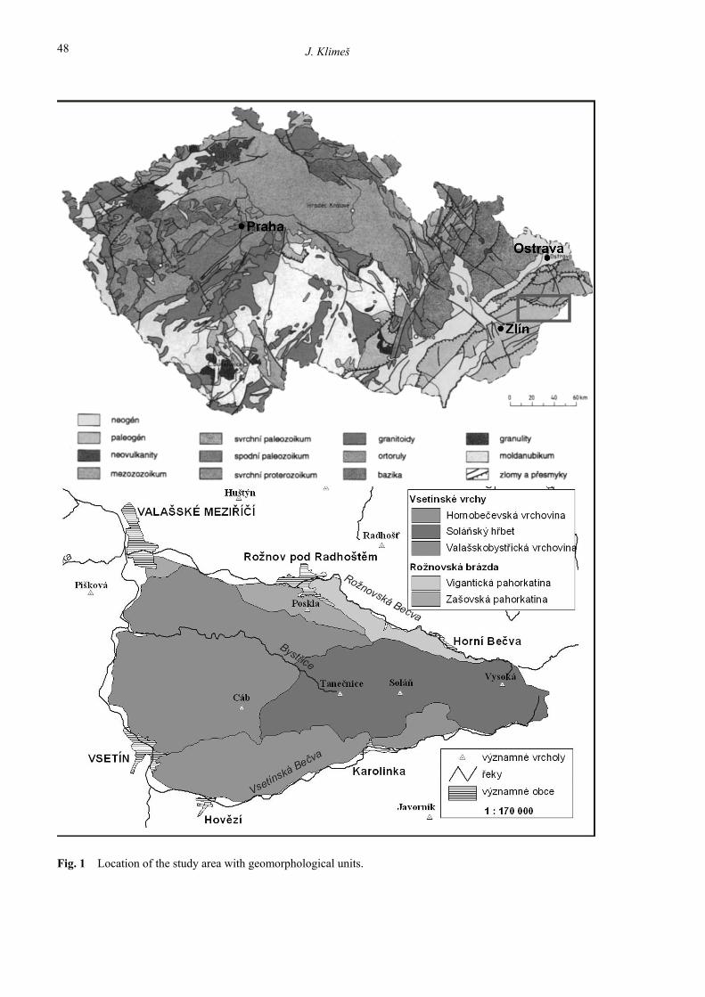
Carpathians covering the geomorphic districts of the Vsetínské vrchy Highland and part of the Rožnovská trough (Fig. 1; Demek et al., 1987), which are spreading east and north east of the city of Vsetín situated close to the border with Slovak Republic. This area is formed by flysh rocks with highly variable composition of the competent, permeable sandstone layers and plastic, rather impermeable claystones and siltstones. The region has been since long time ago recognised (Záruba, 1922-23) as highly susceptible to landsliding. The strong impuls for detailed landslide research came during hevy rainfall event in July 1997 (Hladký, 1998) when more than 1500 landslides occured causing considerable economic loss (Krejčí et al., 2002). Magnitude of this event was also evaluated and compared with other landslide events worldwide.
Large effort focused on preparation of applicablelandslide susceptibility maps, which could be used by local administrations to minimize possible future losses. The thesis are contributing to the sptial prediction of future landslide occurrence by appllying variety of landslide susceptibility models to the single study area providing valuable evaluation of their
J. Klimeš
48
Fig. 1 Location of the study area with geomorphological units.
ANALYSIS OF PREPARATORY FACTORS OF LANDSLIDES, VSETÍNSKÉ VRCHY …
49
input data are landslide inventory represented by points and DEM (digital elevation model) forthe SINMAP model and historical inventory map with geologic, soil, slope, aspect and distance to the tectonic lines preparatory factors maps for the bi-variant statistical model.
The final susceptibility of the studied area was represented by classified values of factor of safety (FS) for the SINMAP model and total weight (TW)calculated by the the statistical model using the following formula:
TW = Wpf1*FRcl1 + Wpf2*FRcl1 + Wpf3*FRcl1 + Wpf4*FRcl1 + .......
Wpf1 is the weight of the first preparatory factor map (e.g. slope map) and the FRcl1 is the failure rate (Wieczorek, 1994) of the first class of the first preparatory factor map (e.g. 0°- 5° for the slope map).
Apart from the susceptibility mapping, separate evaluation of each preparatory factors was made calculating the respective failure rates. This evaluation was used to compare susceptibility of each preparatory factor for the landslides included in the historical and July 1997 inventory maps. For the later one, separate evaluation of the susceptibility conditions among landslide scar and accumulation areas was performed.
Each resulting landslide susceptibility map wasevaluated calculating landslide densities and predictive power (Chung and Fabbri, 2003) for thesusceptibility classes. The time partitioning of the known landslides and evaluation of the successful prediction by comparing the portion of the study area defined as “unstable” necessary to capture majority of the predicted landslides, were also used. The latest approach allows to defined “mistake” of the susceptibility models represented by the portion of the total landslide area or number falling to the stable class.
Definition of the susceptibility classes should not only classify the predictive values (e.g. FS or TW) calculated by the models, but also needs to explain meaning of each susceptibility class for the users. The classification of the FS values calculated by the SINMAP model, are shown in Table 1. The resulted values of TW index were classified individually for each model.
main parts summarizing all gained results. The subchapters include results of field works, analysis of landslide preparatory factors, landslide susceptibility models and importance of the slope deformations for erosion processes. Chapter Discussions (7) evaluates and compares the performance of used landslide susceptibility models. Chapter Conclusions (8) sum up main outcomes of the thesis and new knowledge.
METHODS
Several data acquisition techniques were employed to acquire necessary data about landslides originated during the July 1997 rainfall event as well as evidences of previous landslide occurrences. The techniques included aerial photo interpretation and field mapping using mobile GIS technology (ArcPad 5.0.1 software by ESRI and palm top computer iPAQ Compaq; Klimeš and Rothová, 2001) and conventional geomorphologic mapping. The aim of the field work was to gain detailed knowledge about existing landslides within the selected part of the study area and to map important preparatory factors influencing their occurrence. The original data were integrated with available landslide inventory maps to produce several new inventory maps used for the landslide susceptibility models.
The historical inventory map includes all available information about landslide occurrence prior the rainfall event in 1997. The map was compiled from the results of the field work, data from national landslide inventory database maintained by Geofond and results of detailed landslide inventory mapping managed by Czech Geologic Survey. In separate data base was stored information about landslides which occurred during the 1997 rainfall event. These data were later adjusted for deterministic landslide susceptibility model.
The susceptibility of the study area was evaluated using different models ranging from the basic to the more sophisticated deterministic and statistical ones. The historical inventory map and slope map were used as basic susceptibility models. Later, the bi-variant statistical model proposed by Carrara et al. (1995) and deterministic SINMAPmodel (A Stability Index Approach to Terrain Stability Hazard Mapping; Pack et al., 1998) were applied. All the models were pixel-based with the 10 m x 10 m pixel size. The most important model
Table 1 Susceptibility class’s definition for the SINMAP model is using calculated value of the factor of safety(FS).
value of factor of safety (FS) susceptibility class
FS > 1.25 stable 1.25 > FS > 1 conditionally stable
1 > FS > 0 unstable
J. Klimeš
50
Table 2 Landslide densities for the susceptibility classes of the prepared models (l. – landslides, * evaluated for the „unknown“landslides, which were not used for the model preparation).
Landslide densities calculated for the areas of landslides and susceptibility classes
Model/susceptibility class
stable conditionally stable unstable
slope map 0.3 0.8 1.3
historical l. inventory map 0.8 not available 4.7
historical l. inventory map with buffer of 75 m 0.4 not available 5
statistical model 0.6* 0.5* 1.7*
SINMAP model - region 1 0.5 1 1.8
SINMAP model - region 2 0.4 0.8 3
SINMAP model - region 3 0.5 1 2.2
based on their number is 3.2. The magnitudes of landslide events presented in Malamud et al. (2004) ranged between 3.6 and 4 for both ways of landslide event magnitude calculation.
The most successful landslide susceptibility map is the historical inventory map (Table 2) capturing70% of the total landslide area within 14% of the studied region defined as unstable.
The results of the SINMAP model were mostly affected by the morfometric characteristics of three calibration regions into which the entire study area was divided. The best results were gained in the calibration region with the lowest average slope and occurrence of the structural ridges with steep slopes highly contrasting with otherwise gently rolled relief of that region. Considerably worst results were gained in the regions with higher average slope, but without high contrast in the relief topography. Interesting is also conclusion that the SINMAP model was considerably better than the results of susceptibility map based on the slope map. This contraast with theresults in the Aquasparta region (Umbria, Italy), where the slope map and SINMAP model achieved similar results (Klimeš, 2003).
The worst results were obtained by the bi-variant statistical model which tested the use of historical inventory map for prediction of the landslides originated in July 1997. The low performance could be partly explained by the presence of the complex
Explanation of the used susceptibility class displayed with the traffic light colors follows: • Stable – occurrence of landslides is almost
excluded, in some cases, only the accumulation parts of the landslides may reach this zone.
• Conditionally stable – it is not possible to exclude occurrence of the landslides in this zone.
• Unstable – parts of the study area with the most suitable conditions for occurrence of the landslides, the landslide occurrence is only the matter of time range of the prediction. The landslide susceptibility map based on the
historical inventory was devide into two susceptibility classes – stable for areas with no evidence of previous landsliding and unstable defined by the bodies of mapped landslides and 75 m wide buffer zones around them.
RESULTS AND CONCLUSIONS
The extend (in terms of number as well as area) and claimed looses of the landslide event from the July 1997 can not be compared with another known event recorded in the study area. Calculation of landslide event magnitude (Malamud et al., 2004) was used to compare its extreme nature with other landslide events. The resulted magnitude based on area of identified landslides is 2.9 and the magnitude

ANALYSIS OF PREPARATORY FACTORS OF LANDSLIDES, VSETÍNSKÉ VRCHY …
Fig. 2 Landslide susceptibility map of the Vsetínské vrchy Highland prepared according the new definition of the susceptibility classes.
J. Klimeš
52
Hladký, J. ed:. 1998, Evaluation of the july 1997 flood event – comprehensive report of the project. Ministry of Environment, Czech Republic, Prague, http://www.chmi.cz/hydro/souhrn/obsah.html (last visited May 2007).
Hrádek, M.: 2000, Geomorphological effects of the July 1997 flood in North Moravia nad Silezia. Geografický časopis, 54, 2000, 4, 303–317.
Klimeš, J. and Rothová, H.: 2001, Slope deformations in Vsetín region – attempt of introduction of GIS for field mapping of the topographic sheet number 25–23–24. In: Létal, A. (ed.): Proceedings of anniversary conference of the Czech geographical society: „Czech geography in the era of expanse of information technologies“, Olomouc, 25. - 27. 9. 2001, Faculty of Natural Science, Palacky University in Olomouc, Olomouc, 175–180.
Klimeš, J.: 2003, Evaluation of geological conditions on origin and spatial distribution of landslides with the use of engineering-geological maps and the GIS technology. MS, ČGS, Brno, pp. 32.
Krejčí, O., Baroň, I., Bíl, M. and Jurová, Z.: 2002, Some examples of deep-seated landslides in the Flysch Belt of the Western Carpathians. In: Rybář, J., Stemberk, J., Wagner, P. (eds.): Proceedings of the first European conference on landslides, Prague, Czech Republic, June 24. - 26. 2002, A. A. Balkema, 373–379.
Malamud, B.D., Turcotte, D.L., Guzzetti, F. andReichenbach, P.: 2004, Landslide inventories and their statistical properties. Earth Surface Processes and Landforms 29, 687–711.
Pack, R.T., Tarboton, D.G. and Goodwin, C.N.: 1998, Terrain Stability Mapping with SINMAP, Technical Description and Users Guide for version 1.00. Report No. 4114–0, Terratech Consulting Ltd., Salmon Arm, Canada, 76.
Rybář, J. and Stemberk, J.: 2000, Avalanche-like occurrences of slope deformations in the Czech Republic and coping with their consequences. Landslide News, Vol. 13, Kyoto, 28–33.
Saaty, T.: 1990, The Analytic Hierarchy Processes, RWS Publ, Pittsburgh, pp 190.
Záruba, Q.: 1922-23 Study of sliding terrains in Vsatsko and Wallachia. Brno, Čas. Morav. mus. zem., 20–21, 170–180.
landslides in the historical inventory, which did not occur during the July 1997 event. Another errors were introduced through insufficient spatial resolution of the majority of the preparatory factor maps.
The detailed analyses of the susceptibility of each preparatory factor map separately for the scarp and accumulation areas proved differences especially for the geologic conditions and slope dips. Ignoring these differences may also contributed to the low performance of the bi-variant statistical model.
New methodology for preparation of landslide susceptibility maps (Fig. 2) of the Vsetínské vrchy Highland was suggests to use four stability classes defined bellow. • Stable – occurrence of landslides is almost
excluded, in some cases, only the accumulation parts of the landslides may reach this zone.
• Conditionally stable – areas where the stabilized landslides were identified and where it is not possible to excluded occurrence of the new landslides based on results of statistical or deterministic landslide susceptibility models.
• Conditionally unstable – areas with the highest susceptibility defined by statistical or deterministic landslide susceptibility models.
• Unstable – areas with identified active or potentially active landslides in the initial or developed states of their evolution.
REFERENCES Carrara, A., Cardinali, M., Guzzetti, F. and Reichenbach, P.:
1995, GIS technology in mapping landside hazard. In: Carrara, A., Guzzetti, F. eds., Geographical information systems in assessing natural hazards, Kluwer Acad. Publ., Dordrecht, 135–176.
Catani, F., Lombardi, L., Menci, S. and Moretti, S.: 2005, Erosion rates assessment in landslides prone areas,Geophysical Research Abstracts, Vol. 7, Abstracts of the contributions of the EGU General Assemby Vienna, Austria, 24.–29. 4. 2005, EGU 2005, CD.
Demek, J. et al.: 1987, Geographical lexicon CSR. Mountains and lowlands. Praha, Academia, pp. 584.
Chung, Ch-J.F. and Fabbri, A.G.: 2003, Validation of spatial prediction models for landslide hazard mapping. Natural Hazards, 30, Kluwer Academic Publishers, Netherlands, 451–472.
ANALYSIS OF PREPARATORY FACTORS OF LANDSLIDES, VSETÍNSKÉ VRCHY …
53
ANALÝZA PODMÍNEK VZNIKU SVAHOVÝCH DEFORMACÍ VE VSETÍNSKÝCH VRŠÍCH
Jan KLIMEŠ ABSTRAKT: Doktorská práce je zaměřena na prostorovou predikci výskytu svahových deformací v regionálním měřítku s využitímterénního mapování současných i starších svahových deformací a s využitím modelů náchylnosti území k sesouvánívytvořených pomocí technologie GIS. Jedná se o dvourozměrné statistické modely a deterministický model SINMAP.Výsledky modelů náchylnosti Vsetínských vrchů k sesouvání jsou zhodnoceny a porovnány pomocí několika kritérií. Nejlépehodnocený model je spolu s podrobnými znalostmi místních geomorfologických podmínek využit k definici nové, v praxi aplikovatelné mapy náchylnosti území k sesouvání. Detailně byly zhodnoceny vybrané podmínky vzniku svahových deformací porovnáním map těchto podmínek se sesuvyvzniklými v roce 1997 a před touto sesuvnou událostí. Jedná se o následující podmínky: výskyt starších svahových deformací,geologické a půdní poměry, sklon a aspekt svahů, specifická infiltrační oblast, využití půdy, strukturní poměry podloží avzdálenost k tektonickým liniím. Ukázalo se, že výskyt předchozích svahových deformací vykazuje nejužší vazbu s nověvzniklými sesuvy. Ostatní faktory takto silnou vazbu nevykazují také důsledkem své výrazné prostorové variability, kteránení dostatečně podrobně zachycena na použitých vstupních mapách podmínek vzniku svahových deformací. Zároveň tato variabilita vede v některých případech ke vzniku svahových deformací v rámci širokého rozmezí hodnot určité podmínky(např. sklonu svahů) což výrazně znesnadňuje přesnou predikci jejich budoucího rozšíření.