analytical assessment for the process of collecting
TRANSCRIPT

Analytical assessment for the process of collecting additional
data on a suspected hazardous area in humanitarian demining
Cedo Matic, Davor Laura, Roman Tursic, Andrija Krtalic
Zagreb, 2014

Analytical assessment for the process of collecting additional data on a suspected hazardous area in humanitarian deminingCedo Matic, Davor Laura, Roman Tursic, Andrija Krtalic
Publisher: CROMAC-Centre for testing, development and training Ltd. (CROMAC-CTDT Ltd.) Zagreb, Sortina 1d, 10020 Zagreb, Croatia, E-mail: [email protected]
For publisher: M.Sc. Nikola Pavkovic
Editor: Assist. Prof. PhD Andrija Krtalic
Editorial board: M. Bajic, C. Matic, Davor Laura, A. Krtalic, N. Pavkovic
Reviewer: PhD Milan Bajic, CROMAC-CTDT Ltd.
Press: Tiskara Velika Gorica d.o.o.
Cataloguing: A CIP catalogue record for this book is available from the National and University Library in Zagreb under 875533 ISBN 978-953-58057-0-0
Support: This edition was published with financial aid of project TIRAMISU. This project has received funding from the European Union’s Seventh Framework Programme for research, technological development and demonstration under grant agreement no 284747.
Note: The authors of the texts are liable for the content and all information in the text, as well as for lingual structure.
Edition: 1000 copies

Analytical assessment for the process of collecting additional data on a suspected hazardous area in humanitarian demining
Cedo Matic, Davor Laura, Roman Tursic, Andrija Krtalic
Zagreb, 2014


5
PreambleThis publication is a summary of the military doctrine regarding the landmine – minefields use for protection of the forces, objects and the terrain and is interpreted from the point of view of mine action methodology (humanitarian demining). The text is enriched with very valuable original examples, which show and describe the possible situation of the former zone where the warring units were deployed. The user can find there the generic answers about the deployment of the landmines and the mine fields, all in correlation with the former units’ deployment. Besides the mentioned examples, there are given realistic models for analysis of the former situation based on the information that is available in the mine information system (MIS), military maps and memoirs (incomplete and imperfect although the only available) of mine action centres (MAC). The numerous images show the objects of the former separation or the battle zone, being seen from the ground, this enables user to imagine how these objects were looking before. The analytic assessment of the mine suspected area based on described background is considered in the book. It contains all findings that are possible without entering into mine suspected area. In any considered case, the analytic assessment is finalized with the general and specific requirements for the airborne and space borne collecting and producing new, additional data, information and evidences about the former situation.
The remote sensing techniques and technology can support decision making about the mine suspected areas, if included in the processes of a Non-Technical survey and Technical survey. The first operational remote sensing system for the airborne Non-Technical survey is Advanced Intelligence Decision Support System (AIDSS)1. It also uses space assets and was developed, implemented into operational use and validated by mine action operations2. In EU project TIRAMISU3 is foreseen advancement of former AIDSS into T-AIDSS. The objective of this original technology is to enable reliable assessment of the mine suspected area, to propose areas that could be excluded from the suspected area, to define areas that are suspected but never have been considered as suspected, all this without deminers’ entering into the mine suspected area. The entering into the mine suspected area is hazardous and very costly and this is reason to introduce advanced intelligence technology mainly based on the usage of the aerial and space borne images, being sources of new evidences, data, new information and knowledge. The research and development of many tools in the EU project TIRAMISU, which are based on the remote sensing methods, are aimed to match the needs of the mine action in Non-Tchnical Survey and Technical Survey. The exellence in the scientific domain requires high level of exellence in definition of needs and requirements of Mine Action community regarding the remote sensing tools of TIRAMISU. This book provides methodological background for researchers and developers about the mine action theatre where their tools should be applied and should make significant impact.
This book reflects mutual interaction between the researchers, scientists and operations experts from mine action centres and evolution of methods in both domains in practice and in science since 1998.
Milan Bajić
1 Bajić, M., 2010. The Advanced Intelligence Decision Support System for the Assessment of Mine-suspected Areas, 2010 The Journal of ERW and Mine Action, Center for International Stabilization and Recovery, ISSN 2154-1485, Issue 14.3, Fall 2010.
2 Bajić M., Laura D., 2011. Application of Advanced Intelligence Decision Support System in Croatia and Bosnia and Herzegovina gave new experience, International Symposium “Humanitarian Demining 2011” 26th to 268th April 2011, Šibenik, Croatia, book of papers, pp 81 – 84.
3 TIRAMISU - Toolbox Implementation for Removal of Anti-personnel Mines, Submunitions and UXO , 2012-2015. FP7 project 284747.
AnAlyticAl Assessment for the process of collecting AdditionAl dAtA on A suspected hAzArdous AreA in humAnitAriAn demining
cedo mAtic, dAvor lAurA, romAn tursic, AndrijA KrtAlic


cedo mAtic, dAvor lAurA, romAn tursic, AndrijA KrtAlic
7
AbstractThe crucial document for the success of T-AI DSS application is the analytical assessment of the suspected hazardous area (SHA) based on data and information that are available in MIS of MACs. The outcomes of this analysis are the general and specific requirements for the airborne and space borne collecting and producing new, additional data, information and evidences about the former situation in SHA. The requirement for improvement of this module implies the determination of general guidelines for the implementation of this analysis in any MAC’s of mine-affected countries. According to this requirement, within this T-AI DSS’s module, general guidelines for conducting of the analytical assessment for better definition of the SHA and the definition of general and specific requirements for the collection of additional data (with T-AI DSS) for better re-definition of the SHA have been developed.
T-AI DSS is a tool to support decision about the status of SHA. The input includes data from mine information system (MIS), expert knowledge, airborne and satellite data, contextual data, etc. The outcomes are detected and proved positions of indicators of mine presence (IMP) in space, reconstruction of battlefield (in time and space), better (re)definition of SHA, proposals for exclusion from or inclusion in the SHA (thematic maps). The requirement for improvement analytical assessment of (MIS) data module of T-AI DSS refers to the need to determine the general guidelines for the implementation of this analysis in any MAC’s of mine-affected countries. Due to this requirement, general guidelines for conducting of the analytical assessment for better definition of the SHA and the definition of general and specific requirements for the collection of additional data (with T-AI DSS) for better re-definition of the SHA should be developed within this T-Al DSS’s module. Another requirement for the research within the scope of this module is the need to develop simplified version of the T-AI DSS (without the airborne multisensor acquisition and satellite images) that can be used in MAC’s for the support of the SHA assessment, reduction, re-categorisation and inclusion, only with indicators of mine presence and mine absence derived from MIS data and MAC’s standard operational procedures.
AnAlyticAl Assessment for the process of collecting AdditionAl dAtA on A suspected hAzArdous AreA in humAnitAriAn demining

AnAlyticAl Assessment for the process of collecting AdditionAl dAtA on A suspected hAzArdous AreA in humAnitAriAn demining
8
Table of Contents1 Introduction ..................................................................................................................... 9
2 Analytical assessment for collection of additional data .................................................... 10
2.1 Minefield records ....................................................................................................... 11
2.1.1 Minefield records analysis ................................................................................... 14
2.2 Data about marking activities of mine contaminated areas conducted by the military .. 15
2.2.1 Analysis of data about military marking of mine contaminated areas .................. 16
2.3 Military demining records .......................................................................................... 16
2.3.1 Analysis of military demining records .................................................................. 19
2.4 Data about the detected mines ..............................,................................................... 19
2.4.1 Analysis of data about detected mines ................................................................ 20
2.5 Data about mine incidents ......................................................................................... 21
2.5.1 Analysis of mine incidents data ........................................................................... 22
2.6 Projects of demining and technical survey ................................................................. 22
2.6.1 Analysis of humanitarian demining projects ....................................................... 24
2.7 Data about fortifying the units positions .................................................................... 24
2.7.1 Analysis of data about fortifying unit positions ................................................... 26
2.8 Data from military maps ............................................................................................ 26
2.8.1 Data about defensive and offensive activities of units ......................................... 28
2.8.2 Data about engineer support of combat operations ........................................... 30
2.8.3 Data about the use of forces for antitank combat ................................................ 32
2.8.4 Artillery deployment data ................................................................................... 33
2.8.5 Data about liaison ............................................................................................... 34
2.8.6 Analysis of data from military maps ..................................................................... 35
2.9 Terrain and data about the terrain .............................................................................. 35
2.9.1 Terrain analysis .................................................................................................... 37
2.10 Publications about military activities ........................................................................ 37
2.10.1 Data analysis from publications about military activities ................................... 38
3 Integration of data into the system of defence organization of units ............................... 38
3.1 Example of data integration procedure ...................................................................... 40
4 Analytical assessment of suspected hazardous area ........................................................ 42
5 Requirements for data collection ..................................................................................... 43
6 Discussion of applicability, restriction and further research ............................................. 47
6.1 Applicability: ............................................................................................................. 48
6.2 Restrictions: ............................................................................................................... 48
6.3 Further research: ........................................................................................................ 49
7 Conclusion ...................................................................................................................... 50
8 Bibliography .................................................................................................................... 51

Cedo MatiC, davor Laura, roMan tursiC, andrija KrtaLiC
9
1 Introduction
Analytical assessment for the process of collecting additional data on a suspected hazardous area (SHA) consists of an in-depth comprehensive analysis and interpretation of all previously collected data stored in the mine information system (MIS). Furthermore, analytical assessment is a basic stage in the processes of technical and non-technical surveys of SHA. Primary goal of analytical assessment is spatial positioning and contextual interpretation of all the data stored in the MIS. This makes a strong analytical basis for identifying general and special requirements for collecting data on SHA which are missing in the MIS. Analytical assessment and its results (general and special requirements) are desirable preconditions for high quality usage of AI DSS in humanitarian demining.
The results of analytical assessment should provide: • AssessmentoftheconditionoftheSHAbasedonexistingdata, • AssessmentofroughboundariesoftheSHAwithinwhichdatawillbecollectedand • Requirementsfordatacollectioninthefield.
Mine action experience in the Republic of Croatia has shown that minefield records and other fundamental documents about minefield laying do not provide complete and precise data which would enable to determine realistic condition of the SHA. In specific war-time conditions, mine laying documents were not always made, existing documents are incomplete or imprecise, some have been lost or destroyed during the war, and some of them are probably still unavailable. This is why, through analytical assessment, all available data related to mine laying should be researched in a systematic way, in order to make up for the lack of original mine laying documents.
Due to the fact that original mine laying documents are missing or they have not been made at all for certain areas, SHA assessment must be focused on the research of the way in which the war was fought, on history of military activates during the war and on reconstruction of the battlefield. In such conditions, research of consistency of military activities, terrain characteristics and engineer support of combat operations, is of utmost importance in achieving an optimal assessment of the SHA condition.
Analytical assessment comprises the following procedures: investigation of existing data and phenomena, examination of their content, comparison, systematization and gradual integration according to military activities and order of battle on a certain area. In doing so, it is important to explore the chronology of military activities during the war, with a special emphasis on relocations of units and other indicators of organization and implementation of defensive and offensive activities that influenced the construction of barrier minefields.
The experience from the Homeland War in the Republic of Croatia (1991-1995) has shown frequent cases of shifting of defensive lines and positions (temporal component in analyzing the condition of the SHA), introduction of new units into the existent order of battle, certain overlap of areas of responsibility of the units in new situations on the battlefield, or of taking over the positions of the opposing side. Such cases can make the mine contamination situation more complicated. They require serious analytical work through the process of preparing for collection of data in the field.
In order to understand the working process better and to implement the process in a more

AnAlyticAl Assessment for the process of collecting AdditionAl dAtA on A suspected hAzArdous AreA in humAnitAriAn demining
10
efficient way, the tasks of the analytical assessment for collection of additional data may be conditionally divided into three groups:
1. Individual analysis of existing data, entering the data into the MIS, reliability assessment of the positions shown on GIS maps (a part of MIS containing geographical and geodetic bases used for entering end positioning data in the MIS) and defining of a requirement for data collection in the field. 2. Integration of existing data into the system of organization of defensive and offensive activities of the units, improvement of the results shown on GIS maps and definition of a requirement for data collection in the field. 3. Analytical assessment of the initial SHA state, with a list of requirements for collection of additional data about the terrain.
2 Analytical assessment for collection of additional data
First phase of the process of analytical assessment for collection of additional data about a SHA is the analysis of existing MIS data. The tasks of analytical assessment of the existing data comprise the following: • detailedindividualanalysis, • comparisonandlinkingofdata, • spatialpositioning(onGISmaps), • entering(storing)intoMISand • gradual interpretingaccordingtodynamicsoffightinganddispositionofunitsonthe battlefield.
In order to fulfil the tasks of analytical assessment, suitable GIS maps are needed, which will allow marking of geospatial data as accurately as possible. Different symbols, colours, cross-hatches and other signs should be used in data presentation, in order to ensure that the data, functional ownerships and mutual relationships of the elements inside a system of organization of the defence of the units are clearly shown.
Through analytical assessment, additional data for MIS are crated. In order to enter (store) the data obtained by analytical assessment, it is necessary to create adequate overviews in form of vectors and tables. Through final integration of all available data, these overviews will enable detection of new indicators of constructing barrier minefields in certain areas. That is to say that it is necessary to determine positions of all material or contextual data about barrier minefields (obtained by analytical assessment), as precisely and as accurately as possible, on GIS maps, and store them in MIS, in form of a symbol, a line or a polygon. The following overview of analytical assessment tasks (2.1.1 – 2.10.1) comprises data which in practice can appear as existing data or mine contamination indicators in the system of organization of disposition of units in defensive and offensive activities.
The analysis of the following factors has significant impact on fighting characteristics: • Areawherethefightingtakesplace, • Timewhenthefightingtakesplace, • Combatcapabilityoftheopposingtroops, • Leveloftechnicalequippingoftheopposingsides, • Forceandequipmentusageskills.

Cedo MatiC, davor Laura, roMan tursiC, andrija KrtaLiC
11
2.1 Minefield records
Minefield records are original documents about constructed (or laid) minefields. In humanitarian demining activities minefield records are primary documents used to define positions of minefields, determine mine contaminated areas and buildings, and estimate the condition of the SHA.
Through analytical assessment, detailed analysis and examination of data from minefield records is made, with the aim to determine whether they can be used to identify their positions and find barrier minefields in the field. Positions of minefields reconstructed in the office (on the basis of data from minefield records) are shown on GIS maps (Figure 1a). A minefield is shown in MIS in the form of a polygon in the map scale (Figure 1a).
Figure 1. Example of a minefield position (red cross-hatched polygon) according to a minefield record: a) on a 1:25000 scale map, b) minefield sketch in a minefield record.
Reliability of the minefield position shown on a map will depend on the level of precision of orientation data according to a minefield record and on other known data which are in some way linked to the laid minefield.
Minefield records (Figure 1b) very often do not contain all data needed to enable precise identification of a minefield position on a terrain. This is why in a phase of analytical assessment the level of reliability or precision of the minefield position shown on the map is assessed, in relation to orientation points on the terrain and combat positions of the units (Table 1).
a b

AnAlyticAl Assessment for the process of collecting AdditionAl dAtA on A suspected hAzArdous AreA in humAnitAriAn demining
12
Table 1. Criteria for assessment of the reliability level of the shown minefield position.
Assessment of reliability of the
minefield positionCRITERIA DESCRIPTION
5Minefield position is precise according to orientation points from the mine-field record and cartographic data, and is consistent with the defence organi-zation system of the unit.
4 Minefield position is approximate, consistent with the known land objects and auxiliary orientation points.
3Minefield is located within the zone of the main interdiction fire, i.e. within the range of efficiency of infantry weapons in front of fire positions (up to 400 meters).
2 Minefield is located in the area of military activities; it is not possible to deter-mine its more precise location according to known orientation data.
1Minefield is located within the area of disposition of both opposing parties, the role of the minefield in the defence organization system has not been determined.
0 There are no elements which would enable to determine the position of a minefield (the minefield is not shown in the form of a polygon)
Assessment of reliability level of a shown minefield position is important for further exploration of construction of barrier minefields, with the aim of improving the precision of their spatial positioning. I.e., when reconstructing the way of constructing barrier minefields and assessing SHA it is necessary to establish reliability of the positions of minefields determined in the course of office work. Reliability level of an identified minefield position is determined by a team of analysts or by the analyst who has drawn the minefield position on a map (Figure 2). Subjectivity in reconstructing the positions is reduced by using a greater number of assessments done by different analysts in a team.
Figure 2. Examples of positions and barrier minefields (side A-red, side B-blue) according to minefield records created by opposing parties in a conflict, shown on a 1:25000 scale map.

Cedo MatiC, davor Laura, roMan tursiC, andrija KrtaLiC
13
Overlaps of minefields laid by conflicting parties (blue and red side) may indicate imprecision of defined positions of some minefields, shifting of confrontation lines during the war or other specific phenomena during war-time military activities. If there are any dilemmas concerning the accuracy of the currently obtained situation, they are eliminated through certain check-outs and revision of analytical data, or gradually, through other analytical assessment tasks and final integration of all data.
On the basis of assessment of the precision of positions of minefields, a need for collecting additional data is expressed, which should enable more precise identification of minefield positions in the terrain.
In the analysis of minefield records, certain data (Table 2) may appear as mine contamination indicators. Through the procedures of integration and comparison with other data, they will assist in examination of construction of minefields in a neighbouring area, where defence of a certain unit is organized.
Table 2. Data on indicators of mine contamination in the area, which may be found during the analysis of minefield records.
No.Data –
mine laying indicators
Description of indicator
characteristicsResearch task
1. Firing facilities (shelters, bunkers, trenches)
Consistency of erection of firing facilities with construction of minefields
Identify the type and position of firing facilities within a defensive position.Reconstruct a defence system on the basis of firing facilities.Identify - assess presence of mines and their distance from the firing facilities.
2. Fortifications (classes and types)
Consistency of erection of fortifications with construction of minefields
Identify - assess positions and line of fortifications.Identify - assess construction of minefield s as part of fortifications, in their vicinity and in gaps.
3. Characteristics of the location of the known minefields
Analogy of construction of barrier minefields in other locations with the same characteristics
Identify - assess other locations with the same characteristics as the known locations of minefields.
4. Types and quantity and/or layout of mines within a minefield
Establishment of a spatial framework in which the minefield was laid according to features of mines laid
Identify – assess minefield boundaries,Identify - assess distance of their own minefields from the position of units, on the basis of lethal or wounding range of mines laid
5. Presence of passages through minefields
Indicator of military activities in front of a minefield
Identify – assess presence of firing positions and minefields in front of existing minefields.
6.etc.
Strength of the unit for which a minefield was laid
Indicator of the way in which defence was orga-nized with construction of minefields
Identify- assess defence lines of a unit witch consist of barrier minefields, according to the strength and organizational structure of the unit and terrain conditions.

AnAlyticAl Assessment for the process of collecting AdditionAl dAtA on A suspected hAzArdous AreA in humAnitAriAn demining
14
Figure 3. Example of assessment of a minefield belt on the basis of characteristics of a known minefield: a) A sketch of a position of a minefield, from the minefield record, on an airborne colour image. b) Assessment of a barrier minefield belt (irregular polygon in the middle of the Figure) on the basis of data from the minefield record, on a 1:25000 scale map.
Data according to minefield records and defined positions of minefields are entered into a table, which will enhance visibility of data, attribute linking of data and perceiving of relevant indicators about construction of barrier minefields in a certain broader area.
The following tasks of analytical assessment should provide additional data about minefields. Newly collected data should be added into the table and their influence on the existing data should be found, and precision of previously established positions of minefields should be enhanced. Presentation of analytical data about minefields in a table will prove very helpful for research activities, especially when greater number of records are available and when we research the way in which barrier minefields were constructed in a certain area.
2.1.1 Minefield records analysis
The tasks of analyzing data from minefield records stored in MIS are: • Determine,asaccuratelyaspossible,thepositionofeachminefieldonaGISmapand enter the positions into MIS in the form of polygons. • Assessreliabilityofpositionsofeachminefieldshown,inrelationtoknownorientation points and battle positions of the units. • Definetheneedsforcollectingadditionaldatainthefield,whichwillenablemoreprecise determination of the positions of minefields. • Analyzingtheminefieldrecords,registerindicatorswhichcanassistinreconstructionof the way in which construction of minefields was organized as part of defensive order of battle. • Relevantdatafromminefieldrecordsshouldbeclassifiedinatableforacomprehensive research of minefields laying.
a b

Cedo MatiC, davor Laura, roMan tursiC, andrija KrtaLiC
15
2.2 Data about marking activities of mine contaminated areas conducted by the military
During a confrontation, military units conduct activities of marking and fencing off minefields (Figure 4) in order to find them easier, to be able to move through minefields or to prevent their own troops from entering a mine contaminated area.
Figure 4. Example of a sketch of a minefield marking and fencing off. Translation of the Croatian text: ”Minefield fenced off by a wire fence (barbed wire) from our side, at a distance of at least 6 steps from the mine. Marked with a sign „Mines“
Marking data can be found in documents about engineering support of combat activities and construction of minefields, or they are found in the field as formational and make-shift markings. They are very important for identifying mine contaminated areas for which there are no minefield records. Once they are found, they can help to establish, with greater accuracy: • directioninwhichminefieldsstretch, • startingpointofminefieldlayingasaborderlinebetweenaminecontaminatedareaand safe area.
When investigating the organization of construction of minefields, primary data about marking are related to precise identification of the position of the found mark, appearance of the mark, visible descriptive data about the mark, direction marked as a mine contaminated area and the date or rough estimate of the time when the marking and fencing off was made.
Figure 5. Examples of war-time marking of a mine contaminated area: a) sign, b) barbed wire, c) colour.
Marking pins or signs, sticks, posts (of wood, metal, stone or concrete), ribbons, barbed and standard wire, rope, signs and marks on trees, etc. can be found in the field. (5a, b, c). Entire minefields may be fenced off or only a part of the minefield may be fenced off, preventing one’s
a b c

AnAlyticAl Assessment for the process of collecting AdditionAl dAtA on A suspected hAzArdous AreA in humAnitAriAn demining
16
own troops from entering a mine contaminated area. One’s own minefields, enemy minefields and passages inside minefields are fenced off. In the course of general survey, markings with „code meaning“ are found, understandable only to the units that have been in the area. Data are collected from the members of these troops in order to understand the meaning of the markings.
Figure 6. Examples of positions of military markings of mine contaminated areas shown on a 1:25000 scale map.
Positions of military markings of a mine contaminated area are identified on GIS maps and entered into MIS in the form of symbols (Figure 6). This will make them clearly seen and will show which opposing party made them, and will also facilitate their integration with other data in the system of defensive organization of the units.
2.2.1 Analysis of data about military marking of mine contaminated areas
Analysis of available data about military marking of mine contaminated areas stored in MIS should enable to: • Determine,asaccuratelyaspossible,positionsofmilitarymarkingsofminecontaminated areas on GIS maps and store them in MIS in the form of symbols. • Defineaneedforcollectingadditionaldatainthefield,whichwillenablemoreprecise identification of mine contaminated areas or identification of the positions of individual minefields. • Dataaboutmilitarymarkingshouldbeclassifiedinatableforacomprehensiveresearch of minefield laying.
2.3 Military demining records
Military demining records are original documents about military demining (or clearance) of minefields. Military demining records are made by military units which were clearing minefields.
In addition to data about demining conducted by military units of the conflicting parties, this part of analytical assessment comprises the analysis of data about demining conducted by specialized civilian demining forces as well.
In military activities, units conduct demining of entire minefields or partial demining due to a change in tactical situation, when they become an obstacle to conducting military activities or when they are no longer needed. Military units clear their own minefields and detected minefields laid by their enemy.

Cedo MatiC, davor Laura, roMan tursiC, andrija KrtaLiC
17
Most often, military units conduct partial or complete clearance of minefields when they make passages through the minefields along directions of attacks, when they overtake enemy positions and mine contaminated areas which pose an obstacle to further fighting or in other specific war-time situations.
Military units conduct complete demining of certain infrastructure facilities and areas important for revitalization of a community immediately after the war. In addition to military units, complete demining on liberated areas is done by specialized civilian demining units.
Through analytical assessment, detailed analysis and examination of all data about military demining is conducted, in order to use these data (because of their content) for the research of organization of minefield laying through integration with other existing data. Analysis of these data should also define the status of minefields demined by the military and of the areas where military demining was conducted, i.e., it should be determined whether the area is completely free of explosive hazards.
Positions of demined minefields are shown on GIS maps. The positions are stored in MIS in the form of a polygon, on the basis of data about demining (Figure 7a, b).
Figure 7. Example of a position of a minefield demined by the military, shown as: a) a polygon on a 1:25000 scale map, b) a line in a minefield record.
Reliability of the shown position of a demined minefield depends on the content and precision of the minefield spatial orientation data from the military minefield records and on other currently available data which are in some way connected with the demined minefield.
It has been shown in humanitarian demining practice that existing military demining records, as well as minefield laying records, in most cases do not provide precise and complete data about military demining. Often, records of military demining conducted during a conflict do not exist, or the records do not contain precise data which would enable to draw a reliable conclusion about demining results and the status of the demined minefield. Sometimes demining records are found for minefields for which there are no minefield laying records. If a
a b

AnAlyticAl Assessment for the process of collecting AdditionAl dAtA on A suspected hAzArdous AreA in humAnitAriAn demining
18
known minefield was demined, which has been analytically processed and shown in the form of a polygon, positions of demining and mine laying most often match. If partial demining of a known minefield was conducted, only parts of the minefield which have been demined are shown by a demining polygon.
In the analytical assessment phase, the status of minefields that have been demined is assessed (Figure 8) in the following options: • Theentireminefieldwasdeminedbythemilitary. • Apartoftheminefieldwasdemined,therestremainedactive. • Notallmineshavebeenfoundand/ordestroyedinthecourseofmilitarydemining. • Inthecourseofdemining,moremineswerefoundthanshownintheminefieldrecord. • Inthecourseofmilitarydemining,differentclassesandtypesofmineswerefoundthan those shown in the minefield record. • Minefieldstatusinunclear.
Figure 8. Example of analytical data about military demining and minefield laying during war-time military activities shown in a 1:25000 scale map.
On the basis of status assessment, a need for collection of additional data is expressed, which will enable final identification of the status of a military demined minefield. Final decision about the minefield status will be reached after additional examination or confirmation of the status in interviews with persons who participated in demining and/or are familiar with the mine situation in the military demined area. Analytical data obtained from military demining records are compared to analytical data obtained from minefield laying data through a single table (according to paragraph 2.1). A single table should enable attribute linking of mine laying and demining data, with the aim of identifying the minefield status (Figure 8).
In examination of construction of barrier minefields, very important data are those about detection of other classes and types of mines (other than those listed in the minefield record), as well as positions of demined minefields for which there had been no minefield records. Data from demining records for which there are no minefield laying records are classified and registered in a single table intended for a wider analytical purpose in the process of examining mine contaminated areas and making assessments about the SHA.

Cedo MatiC, davor Laura, roMan tursiC, andrija KrtaLiC
19
2.3.1 Analysis of military demining records
The tasks of analyzing data from available demining records stored in MIS are: • Identifythepositionofeachminefieldthathasbeendeminedbythemilitary,asaccurately as possible, on GIS maps, and store these positions in MIS in the form of polygons. • Estimatereliabilityofshownpositions(Table1)ofminefieldsdeminedbythemilitaryfor which there are no minefield laying records or the position of which, according to minefield laying records, does not match the shown position. • Assessiftheminefieldsdeminedbythemilitaryarecompletelyfreeofmines. • Defineneedsforadditionaldatacollectioninthefield,whichwillenabletodetermine the final status of minefields demined by the military. • Bycomparativeanalysisofminefieldlayingrecordsanddeminingrecordsdetermineif clearance and/or moving of minefields to another location has taken place, and if the same mines or other mines were used. • Onthebasisoftheanalysisofmilitarydeminingrecords,registernewindicatorswhich may assist in reconstructing the minefield laying organization within the defensive order of battle. • Relevant data from military demining records should be registered in the minefield records table (according to paragraph 2.1) in order to determine the status of the SHA on the basis of unified records. Data about military demining for which there are no minefield records are registered in this table separately as new information about the mine situation in the area.
2.4 Data about the detected mines
Detected mines are devices which have been detected in the course of technical survey or have been detected in the field by accident. These are: mines, parts of mines, locations of mine burial or locations of mine explosions and mine packaging (Figure 9). This part of analytical assessment does not contain data about mines found during demining activities and mines activated in mine incidents.
Mines and other devices detected in the area of war-time military activities most often are important factual indicators about minefield laying and about the probability of existence of other mines in the area. In mine action practice, data about detected mines are most often gathered through technical survey, general survey, through reports made by local population and from disclosed historical sources.
Figure 9. Examples of detected: a) antipersonnel mines (red circles, PMA-3), b) antitank mines (yellow polygon, TMA-5).
a b

AnAlyticAl Assessment for the process of collecting AdditionAl dAtA on A suspected hAzArdous AreA in humAnitAriAn demining
20
In order to use data about detected mines in the research of minefield laying, it is important to determine the position of the detected mine, its class and type and detection time (date). Data about detected parts of mines, locations where mines were buried and/or positions of mine explosions may have the same importance for the research.
Figure 10. Examples of positions of detected mines in relation to known data about minefields shown on the 1:25000 scale map.
Detected mines are strong indicators which may confirm positions of certain minefields according to minefield records, or detect unknown minefields for which there are no minefield laying documents (Figure 10).
Data about detected mines from unknown minefields are especially important in assessing and researching laying of minefields through integration with other indicators of defensive and offensive activities of military units in a given area. Through analytical assessment of data, the following positions are identified on GIS maps and stored in MIS in the form of symbols: positions of mines, of parts of mines, of detected locations in which mines were laid and of explosions. Imprecisely identified positions of detected devices must not be ignored. They, as well, should be kept and stored in MIS, and a special requirement for collection of additional data should be defined.
Data about detected mines may indicate that some mines have been left in the ground after demining. Also, it may be that some devices have been moved from their original positions in a minefield, or that someone has left them there. In such cases it is very important to determine validity of data for reconstruction of the way in which mine laying was organized.
2.4.1 Analysis of data about detected mines
The tasks of analyzing data about mines stored in the MIS are: • Identify the position, category, type and number of detectedmines on GISmaps, as accurately as possible, and store them in MIS in the form of polygons. • Determine(assess)theknownminefieldstowhichdetectedminesbelongorconclude that they belong to unknown minefields for which there are no minefield records. • Definemissingdataaboutdetectedmines.Additionalcollectionofdatashouldenable more precise pinpointing of positions of detected devices and provide other data important for research of minefield laying. • Analyzing data about detected mines, register indicators which may assist in reconstructing the way in which minefield laying was organized within a defensive order of battle.

Cedo MatiC, davor Laura, roMan tursiC, andrija KrtaLiC
21
2.5 Data about mine incidents
Mine incidents are undesired events that result in harm of people or animals, caused by explosion and fragmentation of mine body parts, that occur after activation of a mine. Mine incidents inside the area of military activities, as well as detected mines, may be important as factual indicators about minefields or probability of existence of other mines in the area.
On the basis of determined positions of mine incidents (Figure 11) and the type of activated mines, existing minefields may be confirmed according to minefield records, and at the same time unknown minefields for which there are no minefield records may be detected. In mine action practice, data about mine incidents are mostly gathered on the basis of existing records of mine incidents, gathering data from local population about unregistered incidents and studying historical data about mine accidents during military activities. Data about incidents which help to detect unknown minefields are especially important in research of minefields laying, through integration with other indicators of defensive and offensive activities of the units, with the aim of detecting the way in which minefields were laid in areas for which insufficient data about mine laying exist.
Figure 11. Example of the positions of mine incidents in relation to known data on construction of barrier minefields, shown on a 1:25000 scale map.
Due to the fact that positions of mine incidents may be strong indicators of mine contamination, data about every incident that occurred during the war is equally important as those about mine incidents that occurred after the war. Selection of symbols for presenting incidents on GIS maps according to categories of victims, and especially according to conflicting sides, make them visually stand out when they are connected with other data about mine laying or with mine contamination indicators.
Mine incidents that occured during the war in deffensive and offensive activities may indicate a complex mine situation in the area. For example, incidents that occured within the defense zone of a military unit may indicate: • thattheunithasnotkeptrecordsaboutminelaying,orthattheirrecordsareimprecise, • thatthesameareahadpreviouslybeenkeptbytheopposingparty,whichalsohadlaid mines, • that opposing sidewas entering the area and laidmines and/ormoved the existing mines furtively, etc.

AnAlyticAl Assessment for the process of collecting AdditionAl dAtA on A suspected hAzArdous AreA in humAnitAriAn demining
22
In order to use data about mine incidents in the research of minefield laying, it is important to determine the position of the mine incident, i.e. the position of mine activation, class and type of the mine and time (date) of the incident.
Positions of mine incidents are determined on GIS maps and stored in a special data base within MIS in the form of a symbol. Imprecisely identified positions of mine incidents must not be ignored. They, as well, should be kept and stored in MIS, and a special request for collection of additional data for more precise positioning of mine incidents should be defined.
Data records about mine incidents should be kept in MIS. They should show all relevant indicators about incidents which may help to reconstruct, in the office, the way in which minefield laying was organized within the defensive order of battle. We should investigate data about mine incidents that show that the incidents have occurred outside the area of war-time military activities, i.e. outside the area of actual mine laying, and we should check the validity of data for reconstruction of the way in which minefield laying was organized.
2.5.1 Analysis of mine incidents data
The tasks of analyzing data about mine incidents stored within MIS are: • Identifythepositionsofmineincidents,asaccuratelyaspossible,accordingtoGISmaps and store them in MIS in the form of symbols. • Determinetheclassandtypeofactivatedmine. • Assess towhichknownminefields themine incidents relateorwhether the incidents occurred in unknown minefields for which there are no minefield records. • Definemissingdataaboutthemineincidentforadditionalcollectionofdatainthefield, which will enable more precise pinpointing of the positions of mine incidents and provide other data important for research of minefield laying. • Analyzingdataaboutmineincidents,detectindicatorswhichmayassistinreconstructing the way in which minefield laying was organized within the defensive order of battle. • Dataaboutmineincidentsshouldbeclassifiedinatableforacomprehensiveresearchof minefield laying and for other mine action purposes.
2.6 Projects of demining and technical survey
Humanitarian demining projects (demining and search projects) contain data about earlier assessments of the SHA status in the area where demining activities have been conducted. In the course of demining, mines from the project area are detected and removed from known minefields and/or unknown minefields.
The analysis of humanitarian demining projects is very important in order to determine if known minefields have been completely demined in a given project, to determine the scope of demining, whether any unknown mines have been detected, and what directions and ways of mine laying may be expected in the vicinity of the demined area. When analysing demining results, data about found mines are compared with data about demined minefields, and their status is defined in terms of absence of mines.
If results obtained through demining are not consistent with the data about the mine situation assessment from the project documents, the inconsistencies should be researched in more detail, as well as the possible impact on the assessment of the SHA status in surrounding areas.

Cedo MatiC, davor Laura, roMan tursiC, andrija KrtaLiC
23
Figure 12. Example of defining positions of minefields according to results of projects of humanitarian demining of a road belt, shown on a 1:25000 scale map.
If unknown minefields were found in the course of demining, data about their locations should be used in research of the organization of minefield laying in the given area. For the purpose of researching minefield laying in the surrounding areas, the position of the shown minefield before demining of the surrounding area should be corrected in line with the locations of the found mines (Figure 12).
Records about the mines found in the course of demining should be kept in a separate data base within MIS. They should show relevant indicators which will help in the research of minefield laying (Figure 13).
When developing humanitarian demining projects, in terms of SHA research, it is useful to modify the projects so that the minefields are demined in their entirety, and so that, at the same time, missing data about the layout of the minefield outside the project area are gathered (Figure 13). Also, during demining, it is important to record other mine contamination indicators found, which may help to reconstruct the organization of minefield laying on a broader area outside the project area (firing positions, etc)
Figure 13. Example of assessment of a new area for demining in line with data about detected mines and fortifications, shown on a 1:25000 scale map (upper right corner of the Figure) and on an orthophoto map, scale 1:2000.
Usability of results of a demining project in research of minefield laying is based on category, type, quantity, layout and position of detected mines or mine parts. With regard to this, one should bear in mind which demining method was used, i.e. how reliable are the obtained indicators about detected mines. In mechanical demining, mines are activated and relevant

AnAlyticAl Assessment for the process of collecting AdditionAl dAtA on A suspected hAzArdous AreA in humAnitAriAn demining
24
indicators about types and positions of destroyed mines cannot be accurately determined. In addition, in mechanical demining, mines and their parts are scattered around.
2.6.1 Analysis of humanitarian demining projects
The tasks of analyzing humanitarian demining projects stored within MIS are: • Identifytheposition,category,typeandnumberofdetectedmineswithintheproject area and store them in MIS in the form of symbols. • Comparethemwithexistinganalyticaldatatodeterminewhethertheminefieldsplanned for demining have been demined and whether any new minefields have been found. • Determinethe impactofdeminingresultsonminefield layingdataalreadyexisting in MIS, enhance precision of positions of minefields previously determined and stored, and update data in line with analytical tables.
2.7 Data about fortifying the units positions
Fortification of positions of units is conducted by engineering forces, with the aim of creating as favourable conditions as possible for operation of ones own forces. At the same time, this should make enemy operations harder. Fortifications are erected according to a plan, in line with disposition of units, organization of firing activities and terrain conditions in which defensive and offensive activities will be conducted.
In most cases, minefield laying is consistent with erection of fortifications. When a minefield is laid, the distance from the minefield to the fortified positions (bunkers, trenches, firing shelters) is adjusted, so that fire from infantry weapons is effective in the minefield belt. This functional link between fortified positions and minefields, makes firing fortifications a very strong mine contamination indicator. Thus, when existing data about mine laying do not show realistic condition of minefields laid, data about fortifications are extremely important in identifying mine contaminated areas and SHA.
Through analytical assessment we investigate data about engineering works and fortifications that have already been detected in the field, or data about fortifications that have been obtained from existing documents. Data about fortifications are recorded in military situation maps, plans of engineering activities and in records of fortifications. Data about fortifications
may be found in some minefield records, demining records and other combat documents, on airborne (Figure 14) and satellite images of the terrain.
Figure 14. Example of locations of fortified
positions detected in the field, shown on an
orthophoto map, scale 1:2000.

Cedo MatiC, davor Laura, roMan tursiC, andrija KrtaLiC
25
Through analytical assessment, detailed analysis and examination of data on fortifications is conducted, in order to establish how reliable detected fortifications are in the reconstruction of the way in which minefields were laid according to firing positions of the units. For research of mine contaminated areas and SHA, primary data about fortifications are related to precise identification of positions of fortified facilities, recognition of the firing facility and direction of firing, as well as to the time period when the found fortifications were used.
Through analytical assessment, positions of detected facilities are shown with appropriate symbols on GIS maps and prepared for further research through integration with other data or mine contamination indicators (Figure 15). Imprecisely determined positions (due to incomplete or raw information) of fortifications must not be ignored. It is necessary to position them, as precisely as possible, on the basis of data and GIS maps, and to store them in a separate data base within MIS. This data base is a source of special requirements for collection of additional data with the use of AI DSS.
In the area of combat disposition of units, it is very important to detect the forward defence line, second defence line, gaps between the units and defence flanks, directions trafficable for mechanized armoured unites, positions of combat security, forward protection positions, rocket artillery positions and other elements in the disposition, which are protected with minefields, according to tactical and technical principles of defence organization or according to the way in which the war is fought.
Figure 15. Example of data from a military map (black symbols) and those detected in the field (red symbols) about engineer protection of positions from Grabar hill (trigonometrical point (tp) 1067) to Kruševo hill (trigonometrical poiint (tp) 975) on a 1:25000 scale map. The information from a military map on fortification erected around the defence position on Grabar hill was confirmed through data collecting in the field. In order to define SHA in this area, precise data about positions of units towards South-East (tp 1067 - tp 964 – tp 975 – Crnjak settlement) should be collected in the field. The analysis of this position results in specific requirements for additional data collection using AI DSS.

AnAlyticAl Assessment for the process of collecting AdditionAl dAtA on A suspected hAzArdous AreA in humAnitAriAn demining
26
2.7.1 Analysis of data about fortifying unit positions
The tasks of analyzing data about fortifying unit positions stored in the MIS are: • Determine,asaccuratelyaspossible, locationsof fortificationsonGISmapsandstore them into the MIS in the form of symbols. • Assessatypeoffortificationanditsroleindefencesystemoftheunit. • Definemissingdataonfortificationsinordertogatheradditionaldatainthefield,which will help to determine, more precisely, order of battle and mine contaminated areas. • Analysingdataonfortifications,otherindicatorsshouldbedetected,whichmayhelpin reconstructing the way in which minefield laying was organized within the defensive order of battle.
2.8 Data from military maps
A military map is a topographic map, a theme map or any other analogous overview of the terrain, on which data about assessment and implementation of combat activities are hand-drawn.
A military situation map (Figure 16) is a combat document, which, with the use of tactical symbols, abbreviations and textual clarifications, provides a visual overview of the disposition of units, or a state of a combat situation. In this document, military maps and symbols of the armies involved in the war on the territory of former Yugoslavia are used.
Military situation maps (Figure 16) are generally made from the level of battalion command, brigade command and higher (corps, area command, military district). Company commanders and lower levels of command use situation maps for completion of certain tasks and they mainly destroy them afterwards. This is why the maps of these levels of command can rarely be found.
Figure 16. Example of a part of a military situation map (data shown on a 1:25000 scale map).

Cedo MatiC, davor Laura, roMan tursiC, andrija KrtaLiC
27
Military situation maps can contain data about a location and way of disposition of units, about a composition of the unit’s defence, about boundaries of a unit’s jurisdiction, directions and targets of defensive and offensive activities, information about minefields laying, fortifications, names of the units, date and time-frame of the situation shown on the map, and other data.
Complete data on the combat situation in a certain area are shown on command maps and headquarter maps. At the same time, these maps are a basis for more detailed elaboration of the situation according to lower levels of command, special tasks and elaboration of other combat documents. For example, on the brigade level, in addition to command maps, the following maps are also made: situation maps of engineering activities, of artillery, rocket artillery units and anti-aircraft defence, armoured units, for intelligence activities, for liaison, logistic maps and other maps
When original minefield laying documents do not exist, and SHA assessment is based on investigation of history of war-time military activities and reconstruction of the battlefield, data and information from military maps are very important. In analytical assessment of data from existing military maps, military maps and data that are important for the research of minefield laying are registered.
Table 2. Part of the table showing assessment of data from military maps.
Map name Contents of the map (description of data)
Map of engineer support of combat operations
Fortifications, barriers in the infantry brigade zone
Situation map of an area command Shifting of lines of conflicting parties
Decision by an infantry brigade commanding officer about defensive battle
Disposition of infantry brigades within battalions and compa-nies; antitank combat positions
Tactical operation map Bilateral disposition, directions of attack, dynamic advance-ment plan
Intelligence situation Elements of the order of battle of the opposing side with bar-riers
Noname Contents in line with map 17
Through analytical assessment of data from military maps, existing maps should be classified according to areas they relate to, conflicting sides, military units, and within each unit, according to special features, data contents and chronology of war-time military activities. Military maps and data contained on them are stored into MIS by scanning and transformation into national cartographic systems.
It may be found out through analytical assessment that certain data on the maps made of lower levels of command and special features maps may deviate from the basic map, or they are not consistent with other data. In these cases one should be careful when making conclusions about real situation shown on the map. Deviations may occur due to precision in drawing in data, due to different scales of the maps, different level of data details, way of scanning, latest situation, due to a planning map and even a practice map. At the beginning of research of data from military maps, it is necessary to take into account several existing solutions until real situation is determined. This is achieved by comparing data from military maps with other existing data.

AnAlyticAl Assessment for the process of collecting AdditionAl dAtA on A suspected hAzArdous AreA in humAnitAriAn demining
28
2.8.1 Data about defensive and offensive activities of units
Existing military situation maps may contain data about areas of military activities, directions of defensive and offensive activities and order of battle. These data provide a time frame for research of the way of minefield laying according to organisation of defensive and offensive activities.
Analyzing the data about disposition of units on a map, it is necessary to establish (or assess) elements in the disposition which influence organization of construction of minefields: • defenceregions(in-depthandfront-widedefence)oftheunits, • numberofdefencelines, • forwarddefencelineandin-depthdefencelines, • positionofbattlesecurityinfrontoftheforwarddefence • dispositionofforcesorequipmentforantitankcombat, • existenceofseparatepositions(rocketartillerypositions), • shiftingofdefencelineswithneworganizationofdispositionofunits.
Data about order of battle from military maps (Figure 17), which have an impact on organization of minefield laying, should be positioned, as precisely as possible (by scanning and transformations on the basis of referential GIS maps), and stored in MIS for comparative analysis and integration with other data in the defence organization system of the units. Data about disposition of units should match some already known data about minefield laying. Comparative analysis of data is used to establish which defence lines and individual positions were protected with minefields. If relevant minefield indicators have not been found on the basis of data about disposition of units, lines and belts of minefield laying should be established according to the way in which defence was organized and according to deployment of firing weapons in specific terrain conditions. If existing data are less reliable, a wider area should be established as suspected hazardous area, for safety reasons.
Figure 17. Example of the overview of data about positions of the opposing units (blue and red symbols), which change through time, from military maps in MIS: a) Military map, scale 1:25000 showing data about order of battle. b) Data about order of battle entered and stored in the form of MIS levels.
a b
Cedo MatiC, davor Laura, roMan tursiC, andrija KrtaLiC
29
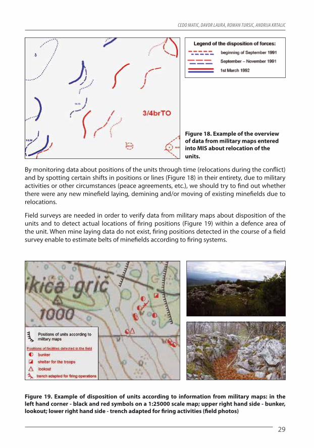
Figure 18. Example of the overview of data from military maps entered into MIS about relocation of the units.
By monitoring data about positions of the units through time (relocations during the conflict) and by spotting certain shifts in positions or lines (Figure 18) in their entirety, due to military activities or other circumstances (peace agreements, etc.), we should try to find out whether there were any new minefield laying, demining and/or moving of existing minefields due to relocations.
Field surveys are needed in order to verify data from military maps about disposition of the units and to detect actual locations of firing positions (Figure 19) within a defence area of the unit. When mine laying data do not exist, firing positions detected in the course of a field survey enable to estimate belts of minefields according to firing systems.
Figure 19. Example of disposition of units according to information from military maps: in the left hand corner - black and red symbols on a 1:25000 scale map; upper right hand side - bunker, lookout; lower right hand side - trench adapted for firing activities (field photos)

AnAlyticAl Assessment for the process of collecting AdditionAl dAtA on A suspected hAzArdous AreA in humAnitAriAn demining
30
2.8.2 Data about engineer support of combat operations
Military situation maps of engineer support show data about laying minefields, erecting fortifications, about condition of roads and use of engineering units in defensive and offensive activities. The maps also show data about disposition of enemy units, minefields laid and demolitions made. This is why data about engineer support of combat operations on military maps deserve special attention in the research of minefield laying.
2.8.2.1 Data about minefield laying are shown on military maps with appropriate tactical signs as planned data or records of the status of a minefield. A map of planned minefield laying contains planning data, e.g.: minefield laying lines and/or planned positions of minefields, units tasked with laying minefields and number of mines planned to be laid in a minefield. A map of the status of a minefield generally contains important data from minefield laying records, e.g.: number of the record, category of the minefield (AT, AP or mixed minefield), number of mines laid (AT, AP), way of activation of mines (pressure, tripwire), minefield width (in meters or steps) and other data which bear operational importance (passages left inside a minefield, etc.).
Figure 20. Examples: a) military map of minefield laying (hand-drawn data about minefield laying on a 1:25000 scale map), b) military map of the defensive disposition of units (hand-drawn data on a 1:25000 scale map).
Military maps also show data about laying of minefields (Figures 20a and b) by the enemy side, collected from various sources: viewing of minefield laying activities, reconnaissance of the enemy forward defence, by breaching enemy minefields, overtaking documents and other intelligence means.
Through analytical assessment, data about minefield laying collected from military situation maps are analysed and investigated in detail, in order to establish their usability for minefield laying research. By analyzing existing data, it is important to establish reliability of positions of planned minefields in relation to actual positions of minefields. It can occur that a minefield was not laid according to the plan, so that these data must be checked out and verified through other analytical assessment tasks and/or by collecting data in the field.
a b

Cedo MatiC, davor Laura, roMan tursiC, andrija KrtaLiC
31
Figure 21. Example of vectorized data (MIS levels) about minefield laying, taken from military maps.
Data about minefields from military maps are stored in MIS (Figure 21), in order to enable their precise comparison with existing minefield records and/or integration with other indicators in the defence organization system. Data about fortifications are also taken from military maps due to the fact that fortifications are most often secured with mines and/or minefields are laid in their vicinity.
By analyzing data from military maps about minefield laying, one should establish if there are any known data about a certain minefield which is shown on the map, or it is a new data. I.e., one should establish if there is an appropriate minefield record or any other data about the minefield position, which confirms that the location is mine contaminated.
Data about completed or planned demolition of bridges (Figure 22), barriers on roads made by causing landslides in cuttings, on serpentines and other “critical points of traffic” should be consistent with organization of defence in narrow routes of attacks passable by armoured mechanized forces and with disposition of equipment for antitank defence. Furthermore, data about demolition should be consistent with positions of minefields around the location of demolition and/or show possible existence of minefields in the location that have not been detected yet.
Figure 22. Example of vectorized data (MIS levels) taken from military maps about demolition in the minefield system.

AnAlyticAl Assessment for the process of collecting AdditionAl dAtA on A suspected hAzArdous AreA in humAnitAriAn demining
32
Through analytical assessment, we should store into MIS all the data from military maps about demolition, as accurately as possible, for the purpose of comparative analysis with other data. On the basis of data about demolition, without other relevant minefield indicators, it is necessary to establish narrow passable routes and critical locations in them which cannot be bypassed, and as such may pose potential locations of demolition or minefield laying. In such cases, when estimating mine contaminated areas, we must determine larger safety zone of possible mine contamination and contamination with explosive devices left after demolition.
2.8.2.2 Fortification data are shown on a military map with appropriate tactical symbols. The maps contain planned fortifications and/or records of erected fortifications (Figure 23a). In the analysis of construction of minefields according to data about erecting fortifications, one should check out if they are consistent with other indicators of the condition of the defence organization system which are a result of previously conducted analytical assessment tasks.
Figure 23. Examples: a) Fortification map with hand-drawn (on a 1:25000 scale map) positions of fortifications, b) elevated fortified position, located according to a datum from a fortification map (RGB image from the ground).
In the phase of analytical assessment, it is necessary to store into MIS all the data from military maps about fortification erecting, for the purpose of comparative analysis and integration with other data. On the basis of fortification erecting data alone, without other relevant indicators of minefield laying in the area, it is necessary to detect fortifications in the field (Figure 23b). On the basis of disposition of firing facilities, directions and belts of barrier minefields are assessed according to terrain conditions suitable for offensive and defensive activities of the confronting sides. In such cases, when assessing mine contaminated areas, a safety zone of possible mine contamination must be determined. Data about fortifications should be positioned on GIS maps as precisely as possible.
2.8.3 Data about the use of forces for antitank combat
Data about antitank combat forces are shown on military maps with appropriate tactical symbols according to their disposition and/or firing positions prepared for overtaking and/or relocation during combat activities (Figure 24a, b). Through analysis of data about antitank
a b

Cedo MatiC, davor Laura, roMan tursiC, andrija KrtaLiC
33
combat forces, one should establish their positions, which at the same time reveal tank routs and antitank minefields. These are locations or positions of disposition of anti-tank battalion groups, anti-tank company groups, individual antitank combat devices and tank positions. Remote and more important positions of antitank combat forces, e.g. tank positions, in most cases are directly secured with minefields.
Figure 24. Examples shown in 1:25000 scale maps: a) organization of antitank combat defence, with data about minefield laying, b) disposition of antitank combat forces on a terrain passable by tanks.
In analytical assessment we should store in MIS all the data from military maps about demolition, as precisely as possible, for the purpose of comparative analysis with other data.
Data from military maps about deployment of antitank combat forces should also be stored in MIS, as precisely as possible, in order to facilitate comparative analyses and linking with other data in analytical assessment of additional data collection about SHA. Data about disposition of antitank combat forces should be consistent with some already known data about minefield laying. In the course of comparative analyses, it is important to establish routes passable by armoured units, and if there are any antitank or mixed minefields on them. If relevant indicators of mine contamination according to known data have not been established, on the basis of data about disposition of antitank combat forces and their firing capabilities and terrain conditions, it is necessary to assess whether any minefields were laid, according to the way of organization of antitank combat forces in defence.
2.8.4 Artillery deployment data
Artillery deployment data (Figure 25a) are presented on military maps (Figure 25b) by showing locations of firing positions, zones of firing activities and targets or narrow locations of firing activities against enemy forces.
Artillery units positioned in isolated locations outside infantry combat disposition, organize direct protection by laying minefields.
A plan of artillery operations defines important firing targets inside the battle disposition of enemy forces. The targets may be forward defence firing positions of the opposing party,
a b

AnAlyticAl Assessment for the process of collecting AdditionAl dAtA on A suspected hAzArdous AreA in humAnitAriAn demining
34
artillery, antitank combat forces and other elements of order of battle which, in general, are protected with minefields. Data about the use of artillery may be strong mine contamination indicators.
Figure 25. Example of a plan of operation of a mortar battery a) encoded list of firing targets (enemy resistant points, mortar positions, command post, lookouts; b) targets shown on a map with their code marks (KP25, KP30, KP28...). The blue arrow shows the link between the data table from Figure “a” and situation in Figure “b” (example: “launch mortar fire to incapacitate the enemy position, which, according to the map, is located on position KP25”)
Data from military maps about artillery deployment should be stored in MIS, as accurately as possible, according to GIS maps, for the purpose of integration with other mine contamination indicators. Data about targets according to plans of artillery operations should be consistent with some of already known data about disposition of the opposing side’s units, as possible mine contaminated regions. If mine contamination indicators had not been established through previous analyses on locations of artillery deployment or of artillery targets, minefield laying in these locations should be researched and assessed.
2.8.5 Data about liaison
Data about a system of liaisons are presented on military maps with appropriate tactical symbols representing liaison types and locations, and unit commands with which liaison is organized.
Among locations to which a certain type of commanding liaison is organized (telephone line, radio connection, etc.) there are regions of resistant points of units, isolated positions of battle security, lookouts, etc. and they should be consistent with some of already known data about minefield laying.
If MIS does not contain any data about minefields or other minefield indicators, detected locations to which liaison is organized should be stored in MIS for the purpose of integration with other data about the system of defence organization of the units. Because of their importance, liaison centres located in depth of the battlefield outside the battle area zone, are normally secured with minefields, and these data should also be entered into MIS.
a b

Cedo MatiC, davor Laura, roMan tursiC, andrija KrtaLiC
35
2.8.6 Analysis of data from military maps
The tasks of analyzing data from military maps stored in MIS are: • Comparing data from military maps with existing analytical data according to tasks (2.1.1 - 2.9.1) we should find out what data are missing according to military maps or what data are needed, in order to check certain existing data, which, at the same time, are important in reconstructing the way in which minefields were laid in the framework of defensive disposition of units. • DatafrommilitarymapswhichdonotexistinMIS,orareimprecise,shouldbepositioned according to GIS maps, as precisely as possible, and stored in MIS according to types of data, and should be attributely described. • Requestsforadditionaldatacollectioninthefield(usingAIDSS)shouldbedefined,and this will enable more precise positioning of data which are shown on military maps: > directions of defensive and offensive activities, > elements of order of battle in the defence region of the units (positions of minefields and fortifications; firing positions of the forward defence, on the flanks and in-depth of defence; positions of antitank combat forces; positions of rocket artillery systems; subsequent and/or reserve positions; look-outs; roads and other data which may be linked with tactical and technical principles and conditions for laying minefields).
2.9 Terrain and data about the terrain
Terrain with all its elevations, hidrography, vegetation, urban and rural areas, roads, economic facilities and other natural and artificial objects has significant impact on organization of defence, and at the same time on minefield laying (Table 3). Combat characteristics of the terrain are inspected and assessed through all the tasks of analytical assessment for the purpose of supporting organization of defensive and offensive activities as a whole, which also involves minefield laying.
Topographic and tactical characteristics of the terrain are studied together with order of battle and tasks of the units, having in mind that they are interlinked and they influence each other. The terrain is assessed both for defenders and for attackers, in order to determine directions of attack with accuracy, and, according to directions of attack, organize defence with minefields. Inspection and assessment of terrain in analytical assessment is conducted on the basis of topographic maps, orthophoto maps and other available data from existing documents (Figure 26).
If original data about minefield laying are missing, data obtained by analyzing the terrain and its characteristics can pose primary data for assessing laying of minefield. The tasks of analysing the terrain inside a battle zone, is to determine the following: • terraincategory:mixed,hills,mountains,plains,forests,karst,swamps,sand,etc. • trafficabilityof the terrainon thebasisof relief characteristics, roadsandexistenceof different natural obstacles (rivers, canals, swamps, steep slopes, gullies, precipices, etc.) which make movement and use of battle equipment harder and even impossible.

AnAlyticAl Assessment for the process of collecting AdditionAl dAtA on A suspected hAzArdous AreA in humAnitAriAn demining
36
Table 3. General indicators for assessment of trafficability of the terrain (Source: Croatian Military Academy „Petar Zrinski“ Military Topography).
Relief
Basic topographic characteristics of the relief
Basic tactical characteristics of the reliefAbsolute heights
Altitude difference
Prevailing slope
Plains with small hills
up to 200 m
up to 50 m
up to 5° Easily trafficable in all directions, possibility to use the most heavy combat equipment, difficult covering
Plains with hills
up to 500 m
up to 200 m
5° – 10° Good trafficability except in some directions, easy covering and protection, very good conditions to establish a firing system
Low alpine
500 –1000 m
up to 500 m
10°– 15°
Difficult usage of heavy combat equipment and vehicles, very easy covering and protection, fa-vourable conditions for establishment of a firing system.
Middle alpine
1000 –2000 m
up to 1000 m
15° – 20° Usage of heavy combat equipment and vehicles possible in certain directions only, very favourable conditions for coverage and protection
High alpine
over2000 m
over 1000 m
over 20°
Limited trafficability, usage of heavy combat equipment practically impossible, very favourable conditions for coverage and protection, heavy landslides and avalanches possible.
Table 4. Trafficability of slopes (Source: Croatian Military Academy „Petar Zrinski“ Military Topography).
Slope Trafficability in dry and hard soil
up to 10° For trucks on wheels with trailers
10° - 20° For 4x4 vehicles and trucks on wheels without trailers
20° - 30° For vehicles on tracks and towing animals
30°- 40° For tanks and self-propelled weapons up to 35°, and up to 40° on short routes.
40° - 60° For manpower with holding on the ground and vegetation
over 60° For trained manpower with special equipment
Figure 26. Example of terrain
conditions on forward defence
shown on a digital orthophoto map, scale 1:2000 and
on a 1:25000 scale map.

Cedo MatiC, davor Laura, roMan tursiC, andrija KrtaLiC
37
Analyzing the terrain, we should investigate natural obstacles (Figures 27a, b) as support in organizing defence that do not call for minefield laying, and thus are indicators of mine absence. These are primarily extremely steep slopes, rivers, lakes, swamps, precipices and other intrafficable land objects for which it is assessed, according to the way the war was fought in that area, that they were not secured with minefields.
Figure 27. Examples of natural obstacles: a) Mountain range, b) Lakes and swamps.
Once indicators of mine absence have been defined (Figures 27a, b) other areas trafficable for combat equipment and/or infantry are more easily spotted, and investigation of minefield laying will be focused on these areas.
2.9.1 Terrain analysis
The tasks of analyzing the terrain and data about the terrain stored in MIS are : • Using the available GIS maps (in conducting other analytical assessment tasks (2.1.1 - 2.8.1)) investigate topographic and tactical characteristics of the terrain within the battle area boundaries which will help in reconstruction of the way in which minefields were laid. • Alongdirectionsofdefensiveandoffensiveactivities,weshouldassess: > terrain categories (mixed, hills, mountains, plains, forests, karst, swamps, sand, etc.) > terrain trafficability according to relief characteristics, roads and existence of different natural obstacles (rivers, canals, swamps, steep slopes, gullies, precipices, etc.) which make movement and usage of military equipment more difficult. • OnGISmaps, assessboundariesof areaswithin thebattle areawhich themselvesare a strong intrafficable natural obstacle, and as such are not secured with minefields and/ or are not used for defensive and offensive activities; they should be stored in MIS as polygons (terrain with high slope, depressions, bodies of water, etc.).
2.10 Publications about military activities
Data from publications (Figure 28) and other historical sources about the conflict may be very useful in investigating minefield laying. Through analytical assessment and continuous reading of published texts, useful information and data may be found, which may be linked with existing data about MIS or may even be a starting point for detection of still unknown areas of mine contamination.
a b

AnAlyticAl Assessment for the process of collecting AdditionAl dAtA on A suspected hAzArdous AreA in humAnitAriAn demining
38
If original data about minefield laying is missing, the following types of analytically useful data may be found in publications: • chronologyofmilitaryactivitieswithshiftingofdefencelines, • dispositionofunitsandlocationsofbattlepositions, • engineeringactivitiesofunitsconductedforthepurposeofsecuringcombatactivities, • locationsofminesonthebasisofmineincidentsoccurredduringthewar, • contactpersonsfromtheunits,forthepurposeofcollectingdataaboutminesituationand • othermilitaryandpoliticalindicatorsthatinfluencedlayingofminefields.
Figure 28. Example of a military map for the operation “Storm 3” (source: general Janko Bobetko „All My Battles“)
2.10.1 Data analysis from publications about military activities
The tasks of analysing data from publications about military activities are: • Investigatepublicationsaboutmilitaryactivitiesanddetectnewdata thatwillhelp in reconstructing the way in which minefields were laid. • NewlydetecteddatashouldbepositionedonGISmapsandstoredinMISintheform of lines, polygons and symbols (directions of defensive and offensive activities, defensive positions of units, locations of minefields, mine accidents, etc.).
3 Integration of data into the system of defence organization of units
Through analytical assessment of existing data (Figure 29), we investigate and analyze their content and assess their reliability for integration into the system of defence organization of units and for assessment of SHA. Through integration of data, their functionality and mutual synergy inside a system of defence organization of units is determined, with the aim of detecting additional indicators about the way in which minefields were laid. (Figure 30a, b).
The task of data integration is to reach indicators which, in a way, confirm consistency of minefield laying with disposition of firing weapons for antitank and anti-infantry combat and terrain conditions in which defensive and offensive activities of the units were conducted.

Cedo MatiC, davor Laura, roMan tursiC, andrija KrtaLiC
39
Figure 29. Example of presentation of existing data in MIS and on a military map in 1:25000 scale according to results of analytical assessment (red symbols - side A, blue symbols - side B).
For ease of identifying connections between data, homogenous areas in terms of military activities should be determined for the area of analytical investigation. These are primarily areas with developed disposition of units of both opposing sides: brigades, battalions and companies. If this is not possible, for spatial framework of the investigation, land objects which determine a specific way of conducting defensive and offensive activities are considered (e.g. defence of settlements, defence at rivers, defence of routes trafficable for tanks, defence of a mountain pass, etc.). It is also important to note that integration of data should be conducted in the order of military activities, that is, in chronological order, in order to avoid vagueness and erroneous interpretation of data due to movements of positions and combat lines or taking of defence positions from the enemy side on the same terrain.
Data linking should be conducted gradually and with care. It is necessary to spot facts which confirm certain state or suggest other possibilities of minefield laying according to disposition of units, changing positions, existing terrain conditions and/or military significance of the area.
Data confirmed to be precise are benchmark indicators. These data should be starting points and support in data integration. Benchmark indicators may be: • precisepositionsofminefields, • positionsofdetectedmines, • mineincidents, • markingsofminecontaminatedareas, • firingfacilities, • specificterrainconditionsinwhichdefensiveandoffensiveactivitieswereconducted.
Less reliable indicators are mostly unchecked and unconfirmed data from military maps or other imprecise and unchecked data.
Procedures and order of activities in data integration is adapted to types and quantity of existing data, way of conducting military activities and other characteristics of fighting on a specific area. All procedures are conducted with the aim of obtaining as clear as possible indicators about the way of minefield laying in the defence system on a specific area.

AnAlyticAl Assessment for the process of collecting AdditionAl dAtA on A suspected hAzArdous AreA in humAnitAriAn demining
40
3.1 Example of data integration procedure
Here is an example of data integration in the system of defence organization for which there are very scarce information and data, such as: • dataaboutmilitaryhistoryinthedefencearea,frompublishedmilitarysources, • dataaboutdefencepositionsintheearlystageoftheconflict, • dataaboutdefencelinesoftheconflictingpartieswhichdonotexistinthefinalstageof the war, • positionsofminefieldsintheconflictzoneshownonamilitarymap(incompletedata), • positionsandtypesofminesdetectedinthefieldafterthewar,and • appearance of the terrain according to military maps in scale 1:25000 and digital orthophoto images (DOF2 and DOF5)
In order to assess initial minefield indicators on a certain area, we need to link data about positions of units according to military maps and zones of efficient firing activities from these positions (Figure 30).
Figure 30. Examples of schemes shown on a 1:25000 scale map a) integration of existing data, b) detail of the efficient firing zone where minefields are expected
A main interdiction fire from the majority of infantry arms is achieved in a 400 meters belt with expected systematic minefield laying. A belt of 400 + 200 meters is a safety zone which comprises additional 200 meters for laying obstacles because of possible deviation from positions of units shown on the map in relation to actual firing positions on the ground. Antitank battle is fought at “close range” on a straight line of up to 1000 meters, with laying obstacles.
In order to determine more precise positions of units then those obtained from military
a b
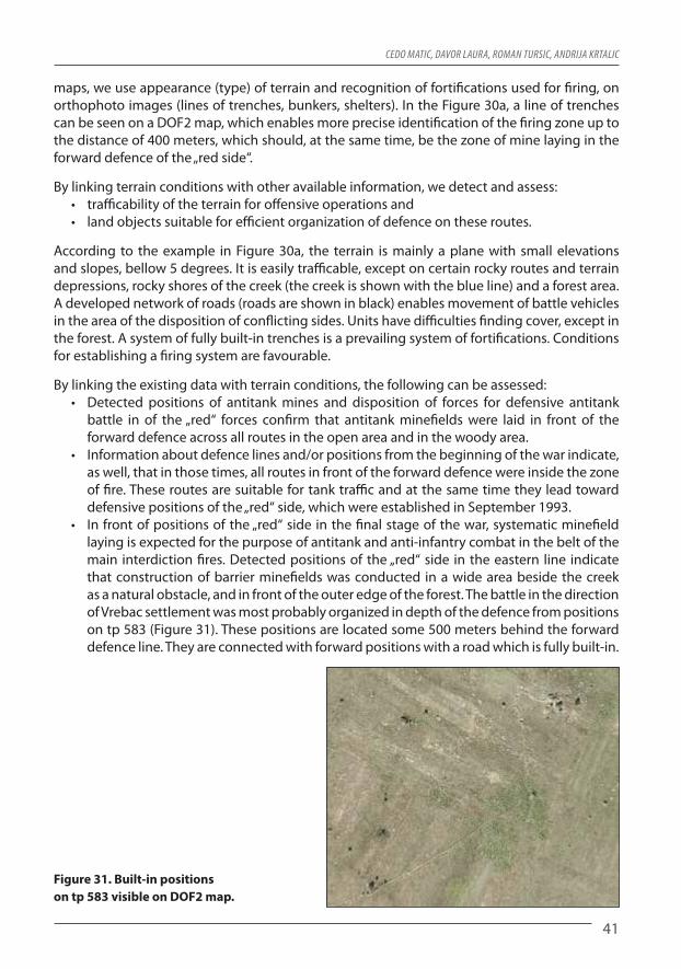
Cedo MatiC, davor Laura, roMan tursiC, andrija KrtaLiC
41
maps, we use appearance (type) of terrain and recognition of fortifications used for firing, on orthophoto images (lines of trenches, bunkers, shelters). In the Figure 30a, a line of trenches can be seen on a DOF2 map, which enables more precise identification of the firing zone up to the distance of 400 meters, which should, at the same time, be the zone of mine laying in the forward defence of the „red side“.
By linking terrain conditions with other available information, we detect and assess: • trafficabilityoftheterrainforoffensiveoperationsand • landobjectssuitableforefficientorganizationofdefenceontheseroutes.
According to the example in Figure 30a, the terrain is mainly a plane with small elevations and slopes, bellow 5 degrees. It is easily trafficable, except on certain rocky routes and terrain depressions, rocky shores of the creek (the creek is shown with the blue line) and a forest area. A developed network of roads (roads are shown in black) enables movement of battle vehicles in the area of the disposition of conflicting sides. Units have difficulties finding cover, except in the forest. A system of fully built-in trenches is a prevailing system of fortifications. Conditions for establishing a firing system are favourable.
By linking the existing data with terrain conditions, the following can be assessed: • Detected positions of antitankmines and disposition of forces for defensive antitank battle in of the „red“ forces confirm that antitank minefields were laid in front of the forward defence across all routes in the open area and in the woody area. • Informationaboutdefencelinesand/orpositionsfromthebeginningofthewarindicate, as well, that in those times, all routes in front of the forward defence were inside the zone of fire. These routes are suitable for tank traffic and at the same time they lead toward defensive positions of the „red“ side, which were established in September 1993. • Infrontofpositionsofthe„red“sideinthefinalstageofthewar,systematicminefield laying is expected for the purpose of antitank and anti-infantry combat in the belt of the main interdiction fires. Detected positions of the „red“ side in the eastern line indicate that construction of barrier minefields was conducted in a wide area beside the creek as a natural obstacle, and in front of the outer edge of the forest. The battle in the direction of Vrebac settlement was most probably organized in depth of the defence from positions on tp 583 (Figure 31). These positions are located some 500 meters behind the forward defence line. They are connected with forward positions with a road which is fully built-in.
Figure 31. Built-in positions on tp 583 visible on DOF2 map.

AnAlyticAl Assessment for the process of collecting AdditionAl dAtA on A suspected hAzArdous AreA in humAnitAriAn demining
42
Objectivity of the state of mine contaminated areas defined through analytical assessment is questionable due to very small quantity of existing data about minefield laying and due to unknown facts about shifting of positions of units and the time period spent on certain positions, and due to disposition of units within certain defence positions.
Because of the fact that the analysis determined that positions of units on military maps are imprecise, in analytical assessment mine contaminated areas are roughly determined according to terrain conditions, with a wider safe area around minefields in relation to the positions on a military map and other unknown facts. This is why the doubts regarding the size of the analytically assessed SHA will result in requirements for collection of additional data.If there are any doubts or vagueness in data integration procedures with possible unclear situations, previously conducted analyses and estimates should be reviewed, that is, a need should be defined for checkout and additional data collection in the field.
4 Analytical assessment of suspected hazardous area
Analytical assessment for collection of additional data about suspected hazardous area results in better estimate (definition) of the existing SHA. SHA is an estimated rough area comprising terrain and buildings for which it was determined, through analytical activities, that it is mine contaminated and/or it is suspected to be mine contaminated on the basis of military activities and reconstruction of the battlefield.
With regard to danger from mines, suspected hazardous areas and buildings pose the same danger as mine contaminated areas and buildings until it is concluded that they do not contain any mines.
Figure 32. Example of a diagram of suspected hazardous area
assessment shown on a 1:25000 map.
Better SHA assessment gives an overview of all factual indicators which influenced the existing SHA condition and requirements for additional data collection which will enable higher quality SHA assessment.

Cedo MatiC, davor Laura, roMan tursiC, andrija KrtaLiC
43
Assessment scheme is a working document (Figure 32) which shows existing data and mine contaminated areas and SHA assessed according to these data.
Assessment data on appropriate GIS maps should enable: • betterperceptionandunderstandingofindicatorsoftheSHAcondition, • moreefficientregistrationandsystematizationofneedsorrequirementsforadditional data collection in the field.
When the SHA area is large, collection of data for better assessment of the SHA condition will take longer time. In this case, existing assessment of the SHA may be used as a basis for conducting certain mine action priority tasks. These may be tasks of SHA marking in the field, mine risk education of local population, priority demining tasks, etc.
Analytical assessments of the SHA conducted after the war as initial assessments, are important in strategic assessment of mine threat for a community and for a way of solving the mine problem.
5 Requirements for data collection
Due to unknown facts about minefield laying which have been established in the course of the overall analytical work, the SHA assessment cannot be regarded as definite SHA condition.
Through the process of analytical assessment, certain requirements or needs for collection of data are registered, which should contribute to optimal identification of positions of minefields, belts of minefields and mine contaminated areas and buildings.
The tasks may be the following: • detection of land objects or orientation points for more precise identification of positions of known minefields • detection of objects and/or engineer activities on the territory of the armed conflict: trenches and roads, firing positions (covers, bunkers), artillery positions, shelters, newly built roads intended for manoeuvres of units in the zone of combat positions, demolitions and existence of other fortifications on roads and narrow passages, • detection of specific land objects used in military activities: roads, bridges, serpentines, gullies, mountain passes, stone walls, bodies of water, fords, embankments, culverts in embankments and on roads, edges of forests, glades, springs, improvised dwellings, • detection of remains of military equipment: vehicles, weapons, packaging,
Furthermore, in analytical assessment we define needs for collection of data on areas and buildings which are expected to be free of mines, due to the way in which military activities were conducted, i.e. they are expected to meet the conditions to be excluded from the assessed SHA.
These are the following areas and buildings: • areas behind firing positions of units, when it is established that these areas belonged to the rear defence line, that defence lines and/or former positions of the opposing side have not shifted • areas where firing positions were, when it is determined that firing belonged to a defence system and that mine laying in the area would pose a direct threat to the unit and would make its manoeuvres in defensive and offensive activities more difficult.

AnAlyticAl Assessment for the process of collecting AdditionAl dAtA on A suspected hAzArdous AreA in humAnitAriAn demining
44
• areas in the belt immediately in front of firing positions, when the distance between the positions of the minefields and firing positions is established, as well as the types of mines used. By placing a certain types of mines on a certain distance from the firing positions, a safety area is made to avoid possibility of wounding or killing the troops from explosion of their own mines. • areas demined by military units, when it is determined that all mines were found and removed. • areas in the separation zone, when it is determined that positions of the opposing sided are situated outside the fire contact in an anti-infantry and/or antitank combat, that no booby traps were laid in the area, or the area itself is an obstacle and is not suitable for conducting offensive activities. • used areas, when it is determined that they have not been mine contaminated, that they have been demined by the military, that mines were removed in other ways, that during the use of the area no mines or mine parts were found, i.e. that there are no reasons to suspect that the areas pose a mine threat.
Figure 33. Example of areas and buildings within a defence organization system, which
are expected to be free of mines, shown on a DOF2 map. The red line shows a line of
forward defence trenches. The line stretches towards North in a function of a hidden road which allows movement of the army to their
positions. The yellow area marks the space in front of firing positions which is expected
to be free of mines because the positions had to be safe from explosions of their own mines. The area which is not marked north
of the yellow polygon belongs to firing positions and it is expected that it is free
of mines (this assumption is confirmed by visible cultivated land.
In general, requirements for collection of additional data are specified as: • generalrequirementsand • specialrequirements.
GENERAL REQUIREMENTS define general needs for detecting and identifying positions of different indicators for which only general indicators of existence in a wider area have been obtained through analytical assessment. These are requirements for detection of fortifications and/or other engineer activities in the area, land objects which are normally used as a support in military activities, natural obstacles and areas which are expected to be free of mines. Larger number of general requirements may be defined when existing data are very scarce, and analytical assessment has not resulted in a more clear Figure about military activities during the war. In such cases most of the requirements may relate to their detection in the entire area covered by analytical assessment.

Cedo MatiC, davor Laura, roMan tursiC, andrija KrtaLiC
45
SPECIAL REQUIREMENTS define a need to detect and precisely define positions of strong indicators of mine contamination and mine absence which have been detected through analytical assessment. Special requirements define narrow areas which contain indicators, objects and/or areas and buildings for which data should be collected. These data should enable: • optimalidentificationofpositionsofminefields,minefieldbeltsandminecontaminated areas and buildings, • exclusionofareasandbuildingswhicharenolongersuspectedtobeminecontaminated from analytical assessment of SHA.
Requirements are specified through a systematic table (Table 5), which should show the following indicators: • areasinwhichdetectionofrequireddataisexpected, • precisedatawhichshouldbecollected, • indicatorsrelatedtorequirementsobtainedbyanalyticalassessment.
Table 5: Example of a list of special requirements for collection of additional data brought about as a result of analytical assessment.
Area information
Data to be collected (land objects according to map TK 1:25000, marks: 419,420,469, 470)
Analytical assessment situation
Varošina (tp538),Vujatovo hill, Gluntuša (tp683)
Detect locations of firing positions inside the disposition of units of the „red“ side on the following line: northern slopes of Varošina hill (tp 538) – Fence – bunker beside the main road (south) – constructions north-east of the auxiliary road for Vujatovo hill – northern and eastern slopes of Vuja-tovo hill.- Detect locations of firing positions of the „red“ and „blue“ side in the area of Gluntuše (tp 683) (shifting of the confronting sides)- Detect tank passageways on the route: Gluntuša (tp 683) (east) – terrain depression (west) – Vujatovo hill
Shelters and bunkers are inside the system of trenches, above the ground and half-built-in with construction made of wood and stone.
Bilaj - Barlete, Rodaice
Identifying shifting of positions of the “red” and the “blue” side during the war (locations of positions, time pe-riod spent on positions, future positions, units on positions)
According to the map of SHA assessment in the separation zone between the red and the blue side
Forest area of Rodaice
Detect firing positions of the „red“ side- in the western edge of the forest (?= Grofija – Gorice - Počadžbina k580 - Tromeđa tp586 and Stilinovka; - in the forest (? = Bucačište tp587 – Jagodnjak k584 – Mudrovčića hill k584 – Dukovčevo hill), on elevations and glades - in the eastern part of the forest (? = to the west and/or east of the forest path on the route Plantaža – Jagodnjak tp588)
According to the situ-ation on the map of analytical assessment. Information about de-fence lines were taken from military maps as imprecise
Terrain conditions in the forest area:- trafficability of the forest for armoured and infantry units: forest paths and clearings which were not registered through analytical assessment, wood cutting on paths and clearings, forest fires, bodies of water and/or depressions of terrain, bridges, rocky areas, glades and areas without vegetation. - constructed and demolished forest objects cottages or shelters constructed before the war and/or during the war
Thin pine forest with openings, crossed with forest paths and clear-ings

AnAlyticAl Assessment for the process of collecting AdditionAl dAtA on A suspected hAzArdous AreA in humAnitAriAn demining
46
Defence region- area of analytical assessment of SHA
Construction of barrier minefields: - in the forward part of defence according to shifting of lines (outmost border of mine laying from the position, first mines from the positions, linear connection – continuity of barrier minefields in front of positions, types of mines laid) - in depth of defence according to shifting of lines (outmost border of mine laying from the position, first mines from the positions, linear continuity of minefields)- mine contaminated roads and clearings in front of the forward part of defence and in depth of defence (positions of mine laying, width of minefields – to the left and to the right from the road, types of mines laid)- specific characteristics of mine laying (passages lefts in minefields and closure of passages, booby traps)- spots and directions of movement of UN peacekeeping forces (demining and procedure with mines, additional mine laying around the spots)- mine incidents (event, location, type of mine, consequenc-es)- demining during the war (location, type of mine, have all the mines been found – removed, reason for demining)- maintenance of existing minefields (replacement of defec-tive mines and mine parts, laying of additional mines)
Unknown
Areas and buildings used during the war:- roads or areas for units manoeuvres (arrival to the posi-tions, planned evacuation directions, usage of the area along the river, areas intended for movement of battle vehicles and other vehicles = mine free areas)- areas and facilities (houses and yards, cultivation of land, cattle on pasture, grass mowing, exploitation of wood)
Unknown
Bilaj - Barlete road
Investigate trafficability of the north road belt 200 m wide on a tank passageway - Babulj settlement (east) - bridge over Jadova river
Unknown
Suvaja creek (east)
Detect positions of tank and artillery positions of the red side, as well as the tracks of vehicles between Suvaja creek and local road on the following route: Rodaice woody area - bridge over Jadova river
As shown on the ana-lytic assessment map, in-depth defence
Defence re-gion- area of the analytical assessment of the SHA
Areas and buildings in SHA which are used after the war:- type and purpose of the area and/or building which is being used, borders of the area,-time frame of usage (since when, constantly, from time to time)- have there any mines been found, mine types and what hap-pened with the mines,- have any mines been found in the surrounding area (posi-tion or micro location, mine types)- have there been any mine incidents (information about inci-dents)-have any fortifications or other indicators of mine contamina-tion been found (position or micro location, type of facility)- Data about new contact points in future data collection.
Unknown

Cedo MatiC, davor Laura, roMan tursiC, andrija KrtaLiC
47
Data collected through field work are stored in existing data bases (MIS), and analytical assessment conducted for collection of additional data, in general, enhances the existing assessment of the condition of SHA in the following ways:
• Ifitisdeterminedthatminelayingactivitiestookplaceonassessedminecontaminated and suspected hazardous areas and buildings, they should be redefined or classified as areas intended for demining.
• ifitisdeterminedthatnominelayingactivitiestookplaceonassessedminecontaminated and suspected hazardous areas and buildings and that they are free of mines, they should be excluded from the SHA.
After completion of analytical assessment and defining of general and special requirements for collection of additional data, we should assess the possibility to use AI DSS for collection and processing of all available data (MIS data and additionally collected data).
6 Discussion of applicability, restriction and further research
Collecting data on mine suspected areas is of great importance for the whole process of mine action. Significant experience in the applicability of AI DSS technology as one of the tools for collecting data in the Land release phase (in fact AI DSS technology of collecting and processing the data was part of the NTS method of collecting data on mine suspected areas) was gathered within the two pilot projects in Croatia (2008-2010) and Bosnia and Herzegovina (2009-2011).
Both pilot projects have pointed to a number of necessary preconditions that must be fulfilled, in order to realize the AI DSS project. It is of great importance that the management of the National Mine Action Authority (N MAA) understands the project, as well as the necessary financial resources and professional team. They should provide full support for the project, because a certain number of employees of N MAA worked on its implementation in all its phases. The support is needed in the analytical data assessment phase, when a joint team for the project implementation is formed and in the course of the project after data collecting. However, N MAA has a key role in the process of validating the results of the AI DSS. The results of applying AI DSS in pilot projects in the Republic of Croatia (RC) and Bosnia and Herzegovina (BH) were very good. The results of AI DSS in both projects (and countries) are presented conservatively (to reduce the risk of errors), only the results with the highest confidence are presented. In the RC, the total treated and processed area was 92.96 km², and 19.5 km² is proposed for exclusion from the SHA with the highest degree of confidence. CROMAC excluded a total area of 43.1 km² after additional nontechnical survey and validation of results. This amount represents even 46.2% of the treated SHA. Very similar results were achieved in BH, where about 47% of the treated SHA was proposed for exclusion. Based on the results of the AI DSS (after data collection and analysis), the inclusion of the areas that were not in the SHA has also been proposed in both countries (6 km² in RC and 3.85 km² in BH). This fact further justifies the use of AI DSS. Through the aforementioned pilot project, AI DSS technology demonstrated its operational readiness for use in the operations of the Land release - as one of the possible and very promising methods for NTS operations.

AnAlyticAl Assessment for the process of collecting AdditionAl dAtA on A suspected hAzArdous AreA in humAnitAriAn demining
48
6.1 Applicability:
The applicability of AI DSS technology is a possible in mine-affected countries which have a larger SHA (for e.g. 200 km²) and where there are less accessible regions (such as mountain areas, plateaus, deserts, savannas and wetlands). AI DSS technology can acquire data and images of the regions that cannot be accessed by surveyors or it is very difficult and associated with high risks.
Further application of AI DSS is possible in RC and BH with limiting factors such as forest areas, finance and politics. The levels of competency of people in N MAA and the interest in new technologies in the area of NTS contribute to a better definition of the SHA. Azerbaijan has demonstrated a great deal of interest and the potential for application of AI DSS technology. However, the political situation is so far the biggest obstacle in the actual application of these technologies, as well as in Afghanistan (which is also a serious candidate for the use of AI DSS technology). Both countries (apart from large mine contamination) are very well structured N MAA, and this is a key fact for quality assessment of project and operational validation of the results.
The AI DSS project might next be applied in Iraq, Iran and possibly, to some extent, in Lebanon, since the first two countries have enormous surface of SHA and relatively well-structured national mine action authorities. However, support for such projects is highly questionable, because the low standard and low salaries would cause resistance of the mine action community, which would impede introduction of technology that would speed up land release and NTS processes that engage less experts than required to conduct a similar amount of work using conventional methods with involvement of a larger number of surveyors.
According to the geographic characteristics and assumptions, AI DSS technology could be applied in northern and central Africa, in areas where there is little vegetation (from Western Sahara - Morocco, through Libya to Egypt) to Eritrea, Ethiopia, Sudan and South Sudan. The limiting factor in these countries is the level of qualification of the staff in national mine action authorities (in some of these countries national mine action authorities do not even exist). Under-qualified staff can hardly keep track of all phases of the application of AI DSS technology. This especially applies to the assessment of the project (analytical assessment) and validation of results with conclusions about the exclusion / inclusion of SHA (for some of the above mentioned countries there is no valid estimate of SHA).
6.2 Restrictions:
In addition to basic assumptions which must be provided (financial resources and management support of national mine action authorities), one of the limiting factors are strictly determined periods of time for performing a particular phase (data acquisition) of the project, since acquisition of images can be optimally performed in the period when the influence of vegetation on the images is minimum (spring or fall). This is true for the countries in which the project has already been implemented as a pilot project (Croatia and Bosnia and Herzegovina), and possibly for Azerbaijan. Application of AI DSS technology would be easier in countries where it is required to acquire images of areas of high visibility, such as savannas and deserts (without dense vegetation - North Africa, Sub-Saharan Africa and Afghanistan). According to previous experience, at the present stage of development of the AI DSS project, it would be difficult to implement the project in tropical zones (from Colombia in South America over the

Cedo MatiC, davor Laura, roMan tursiC, andrija KrtaLiC
49
whole of Indochina in Asia, because of dense vegetation that would prevent acquisition of images from the air).
6.3 Further research:
After the two pilot projects performed in Croatia and Bosnia and Herzegovina, at least one of these two countries should adopt AI DSS technology as part of the Land release process through development of an SOP for the aforementioned technology. It took five years for international mine action community to adopt the Land Release concept through IMAS, after initial consideration. Even nowadays some national mine action authorities are skeptical about the whole concept and do not fully implement it. Therefore, it is necessary to persistently continue to use AI DSS technology in practice, and constantly upgrade it through its application. In this way, it should become an integral part of the Land release concept. There should be a continuous promotion of AI DSS technology and its good results both in Croatia and in Bosnia and Herzegovina.

AnAlyticAl Assessment for the process of collecting AdditionAl dAtA on A suspected hAzArdous AreA in humAnitAriAn demining
50
7 Conclusion
Analytical assessment for collection of additional data about SHA is a process in which we should analyze all existing data individually, present the data, as precisely as possible, on GIS maps and store the data in MIS; identify their connections through integration according to chronological order of military activities and create an analytical assessment of the condition of the SHA.
At the same time, through the process of analysis, we identify missing data which should be collected for better assessment/definition of the existing SHA assessment. In this way, analytical assessment represents a basis for collection of additional data about mine contamination situation in specific areas.
The given concept of analytical assessment presumes that, when making an assessment, it is necessary to detect cause and effect connections between mine laying and the course of military activities.
Analyzing and integrating available data, it is necessary to reconstruct laying of minefields resulting from war-time military activities, and disposition of units on the battlefield.
Investigation and analysis of available data, spatial representation of data on GIS maps and storing in MIS, are basic activities in the analytical process of assessing/defining the SHA. In general, these activities are conducted through continuous work, i.e. continuous redefining of SHA is conducted on the basis of newly collected data.
Specific information tools are created for storing the data, in order to enhance efficiency of data comparison, their integration and establishment of links between construction of minefields and disposition of units in a specific phase of military activities.
The area of analytical work is a rough area which requires to make analytical assessment of the SHA and to define requirements for collection of additional data.
A rough area may be: • theoverallareacoveredbywar-timemilitaryactivities forthepurposeofcreatingthe initial assessment of the condition of SHA for mine action purposes, • areasthatwerenotfullyresearchedthroughpreviousdatacollectionactivities,i.e.areas with imprecise and insufficient indicators of the SHA condition, • areasexpectedtomeetconditionsforexclusionofcertainareasandbuildingsfromthe SHA, • areasplannedforhumanitariandemining,sothatdevelopmentofdeminingprojectscan be as precise and as high quality as possible.
The borders of the area which is to be analyzed are harmonized with order of battle of both conflicting sides and organizational military units which were active in the area.
The above presented procedures define important indicators of the condition of SHA, so that the mine action system in any given moment may have relevant data for efficient planning and organization of humanitarian demining activities.
Results of the overall analytical work will greatly depend on expert military knowledge, skills and affinities of the members of analytic teams of researchers.

Cedo MatiC, davor Laura, roMan tursiC, andrija KrtaLiC
51
8 Bibliography
Bobetko, J. (1996): All my battles (in croatian), Own editions, Zagreb, Croatia
Pahernik, M. (2012): Military topography (in croatian), Croatian Military Academy Petar Zrinski, Zagreb, Croatia
Sekulic, M. (2000): Knin fell in Belgrade (in serbian), Nidda Verlag, Hamburger, Germany
The Republic of Croatia and the Croatian War of Independence 1990.-1995. - Documents, Book 7 (2009) (in croatian), Croatian Memorial and Documentation Centre Homes, Zagreb, Croatia

www.ctro.hr ISBN 978-953-58057-0-0