ancient manipulation of wetlands in the northern maya lowlands · the wetlands are also charged by...
TRANSCRIPT
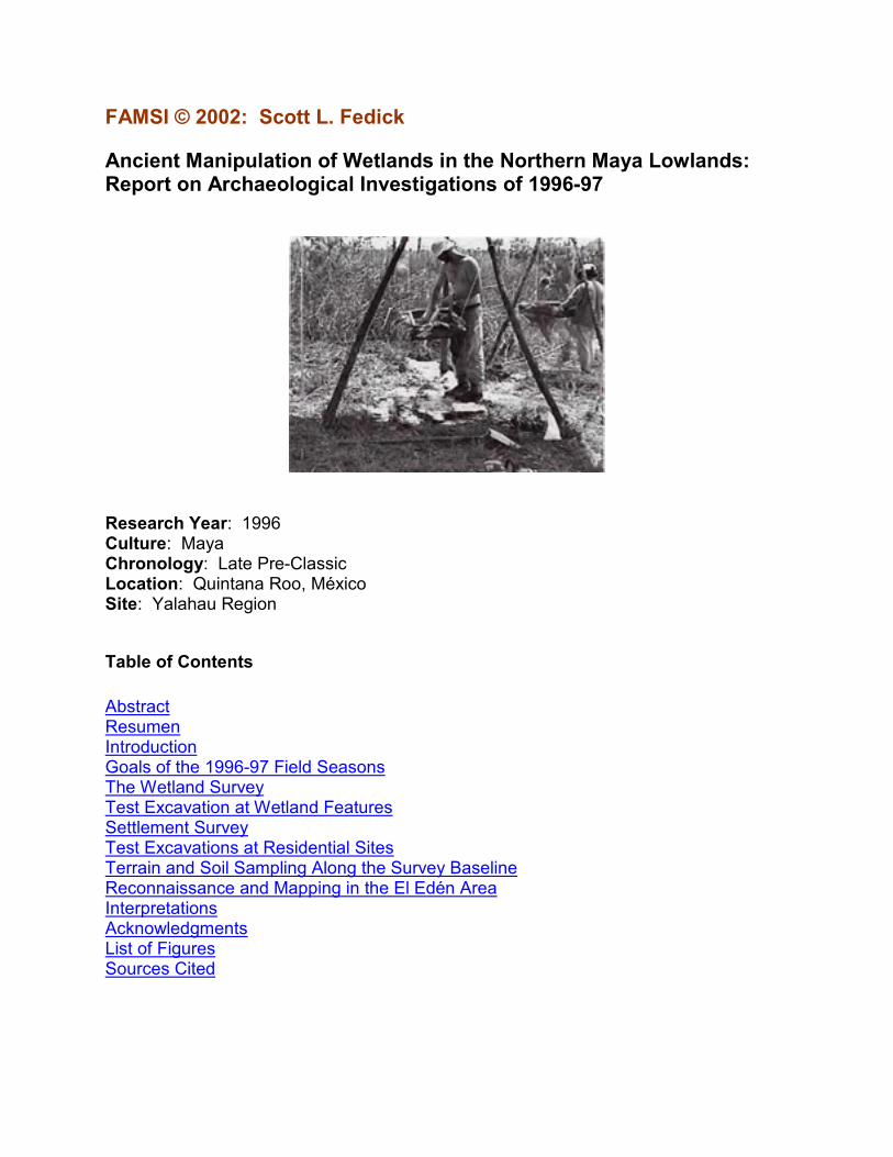
FAMSI © 2002: Scott L. Fedick
Ancient Manipulation of Wetlands in the Northern Maya Lowlands: Report on Archaeological Investigations of 1996-97
Research Year: 1996 Culture: Maya Chronology: Late Pre-Classic Location: Quintana Roo, México Site: Yalahau Region
Table of Contents
Abstract Resumen Introduction Goals of the 1996-97 Field Seasons The Wetland Survey Test Excavation at Wetland Features Settlement Survey Test Excavations at Residential Sites Terrain and Soil Sampling Along the Survey Baseline Reconnaissance and Mapping in the El Edén Area Interpretations Acknowledgments List of Figures Sources Cited
2
Abstract
Field investigations in the Yalahau region of northern Quintana Roo, México, provide the first confirmed evidence for ancient management of wetlands in the northern Maya Lowlands. Constructed features within a seasonally inundated wetland at the El Edén Ecological Reserve consist of alignments of limestone boulders and slabs apparently intended to function as dikes and check-dams to control water and sediments. Associated settlements have been assigned to the Late Preclassic period (ca. 100 B.C. - A.D. 400). Potential uses of the wetlands include intensive cultivation of domesticates, management and harvesting of periphyton for use as fertilizer, and management of edible wetland resources such as cattail (Typha latifolia) and apple snails (Pomacea flagellata).
Resumen
Las investigaciones de campo en la región de Yalahau al norte de Quintana Roo, México, proporcionan la primera evidencia confirmada del manejo, en la antigüedad, de tierras pantanosas en las tierras bajas mayas del norte. Los elementos construídos dentro de un pantano que se inunda estacionalmente en la Reserva Ecológica El Edén, consisten en alineamientos de rocas de piedra caliza y losas hechos con la aparente intención de que funcionaran como diques y represas para controlar el agua y los sedimentos. Se han asignado asentamientos asociados con el período Preclásico Tardío (ca. 100 a.C. - 400 d.C.). Entre los usos potenciales de los terrenos pantanosos está el cultivo intensivo de plantas domesticadas, el control y cosecha del perifitón para su uso como fertilizante, y el control de los recursos comestible de las tierras pantanosas tales como la enea (Typha latifolia) y los caracoles de agua dulce (Pomacea flagellata).
Submitted 12/01/1997 by: Scott L. Fedick [email protected]
Introduction
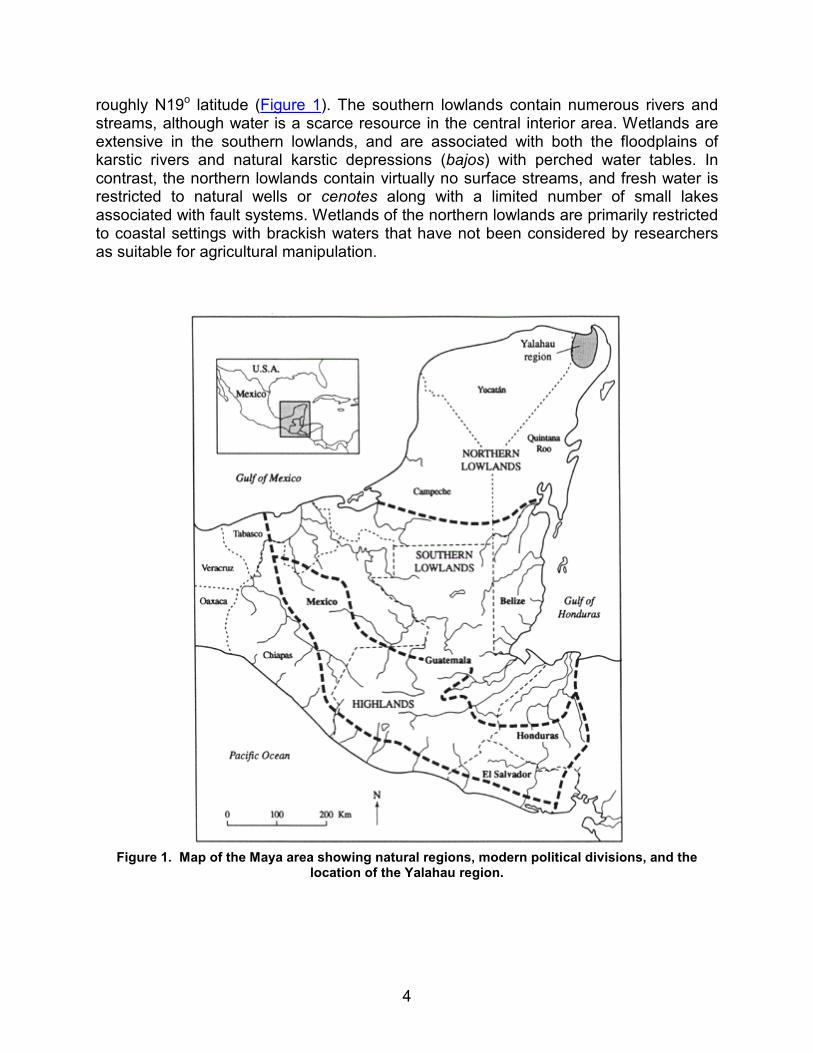
The manipulation of wetlands for agricultural production by the ancient Maya of southern México and Central America (Figure 1) has been the topic of much research
3
and debate in recent years (Culbert et al., 1990; Fedick, 1996a; 1996b; Fedick and Ford, 1990; Pohl et al., 1996; Pope and Dahlin, 1989; Turner and Harrison, 1983; Turner, 1993). Central issues concerning the ancient Maya use of wetlands are (1) the types of wetlands that were exploited, (2) the forms of wetland manipulation practiced, (3) the dates during which wetland manipulation was practiced, and (4) the relative contribution of wetland cultivation to ancient subsistence. Recent investigations in the Yalahau region of northern Quintana Roo, México (Figure 1), provide the first confirmed evidence for ancient management of wetlands in the northern Maya Lowlands. The evidence indicates a previously unreported form of management in a wetland environment that differs significantly from reported sites of ancient wetland use in the southern Maya Lowlands.
Prior to the 1970s, the prevailing perception of ancient Maya settlement pattern and subsistence practice was one of low regional population densities, a lack of true urban centers, and agriculture based on extensive slash-and-burn cultivation of maize as a primary crop within a hostile tropical environment that precluded intensive or fixed-plot agricultural systems. In more recent years, studies have documented the urban nature of many ancient Maya cities, have recorded high regional settlement densities that may have averaged 250 people per square kilometer in the central-southern lowlands, and called into question the ability of slash-and-burn agriculture to support the new perception of ancient Maya population and settlement pattern. In response, a number of researchers proposed a variety of crops as alternatives or supplements to maize (such as tree and root crops), and offered initial evidence for intensive cultivation systems such as hillslope terracing and manipulation of wetlands for agriculture through construction of drainage canals and raised planting platforms (Harrison and Turner, 1978; see also Fedick, 1996b).
In recent years, the majority of attention and debate in Maya subsistence studies has focused on issues pertaining to wetland cultivation (see Fedick, 1996). By the 1980s, some researchers envisioned wetland cultivation as the main agricultural system of the southern Maya Lowlands, where as much as 40 percent of the land area consists of wetlands. Other researchers questioned much of the evidence for wetland manipulation and demonstrated that there is a significant range of wetland ecosystems in the lowlands, with highly variable suitability for agricultural manipulation. The timing of wetland manipulation has also been the subject of varying opinions, with some researchers linking labor intensive wetland manipulation to peak regional population levels of the Late Classic period (ca. A.D. 600-900). Others have associated wetland use with certain environmental conditions (climate and water-table level) that were only amenable to wetland cultivation during restricted periods of time, primarily during the Preclassic period (ca. 2000 B.C. to A.D. 250). To date, all cases of ancient Maya wetland manipulation, both suggested and investigated, have been restricted to the southern lowlands (Figure 1).
The tropical lowlands of the Yucatán Peninsula consist of a karstic limestone platform that tilts downward from south to north. An environmental gradient also exists in which elevation, topographic relief, rainfall, and forest-canopy height all decrease from south to north. The peninsula is generally divided into the northern and southern lowlands at
4
roughly N19o latitude (Figure 1). The southern lowlands contain numerous rivers and streams, although water is a scarce resource in the central interior area. Wetlands are extensive in the southern lowlands, and are associated with both the floodplains of karstic rivers and natural karstic depressions (bajos) with perched water tables. In contrast, the northern lowlands contain virtually no surface streams, and fresh water is restricted to natural wells or cenotes along with a limited number of small lakes associated with fault systems. Wetlands of the northern lowlands are primarily restricted to coastal settings with brackish waters that have not been considered by researchers as suitable for agricultural manipulation.
Figure 1. Map of the Maya area showing natural regions, modern political divisions, and the
location of the Yalahau region.
5
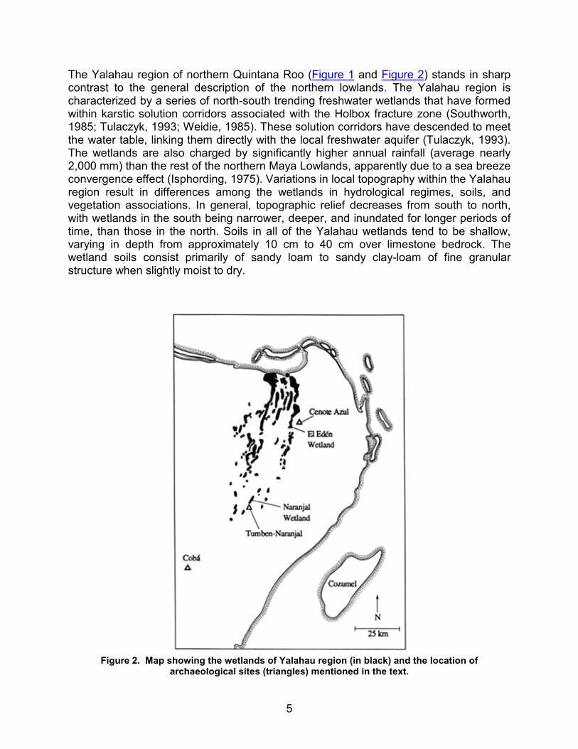
The Yalahau region of northern Quintana Roo (Figure 1 and Figure 2) stands in sharp contrast to the general description of the northern lowlands. The Yalahau region is characterized by a series of north-south trending freshwater wetlands that have formed within karstic solution corridors associated with the Holbox fracture zone (Southworth, 1985; Tulaczyk, 1993; Weidie, 1985). These solution corridors have descended to meet the water table, linking them directly with the local freshwater aquifer (Tulaczyk, 1993). The wetlands are also charged by significantly higher annual rainfall (average nearly 2,000 mm) than the rest of the northern Maya Lowlands, apparently due to a sea breeze convergence effect (Isphording, 1975). Variations in local topography within the Yalahau region result in differences among the wetlands in hydrological regimes, soils, and vegetation associations. In general, topographic relief decreases from south to north, with wetlands in the south being narrower, deeper, and inundated for longer periods of time, than those in the north. Soils in all of the Yalahau wetlands tend to be shallow, varying in depth from approximately 10 cm to 40 cm over limestone bedrock. The wetland soils consist primarily of sandy loam to sandy clay-loam of fine granular structure when slightly moist to dry.
Figure 2. Map showing the wetlands of Yalahau region (in black) and the location of
archaeological sites (triangles) mentioned in the text.
6
The Yalahau region has been subject to relatively little archaeological research prior to the initiation of the Yalahau Regional Human Ecology Project in 1993 (Andrews, 1985; Fedick and Taube, 1995). Our recent investigations indicate that the Yalahau region was densely populated in ancient times, as evidenced by the existence of numerous civic-ceremonial centers and the remains of extensive residential communities. Occupation and architectural construction in the area appear to have peaked during the latter part of the Late Preclassic period through most of the Early Classic period (ca. A.D. 100-450), with a rather ephemeral resettlement occurring in some parts of the Yalahau region during the Late Postclassic period (ca. A.D. 1250-1520).
Constructed features within the wetlands of the Yalahau region were first recorded in 1993 during systematic survey at the site of Tumben-Naranjal, adjacent to a wetland in the southern area of the Yalahau region (Fedick and Hovey, 1995). These features consist of three spatially associated rock alignments within the narrow floodplain margin of the Naranjal wetland. While the alignments might constitute evidence for wetland manipulation, the features do not differ greatly from alignments encountered on the nearby slopes above the wetland, and may have functioned originally as terrace retaining walls for rain-fed cultivation at a time when the water table may have been slightly lower than today.
In the spring of 1994, botanist Dr. Arturo Gómez-Pompa discovered a rock alignment within the main body of the wetland at the El Edén Ecological Reserve (Figure 2). Reconnaissance inspections of the El Edén reserve were conducted by the current authors in 1994 and 1995, and a number of rock alignment features were noted throughout the wetland, as well as numerous ancient settlements in the vicinity of the wetland. In 1996 Scott Fedick initiated a systematic survey of the El Edén wetland, and graduate student Bethany Morrison began a study of ancient settlements associated with the wetland.
Goals of the 1996-97 Field Seasons
The goals of the 1996-97 field season were to supply data that would aid in determining (1) the nature and extent of wetland modification at El Edén, (2) the degree of clustering of settlement around the wetlands as opposed to the surrounding uplands, (3) the chronological placement of wetland manipulation and associated occupation, and (4) the testing of alternate hypotheses concerning the kinds of resources managed or cultivated within the wetlands.
In order to attain the project goals, six components of field research were conducted: (1) complete survey of the El Edén wetland with recording of all cultural features; (2) test excavation at a sample of the wetland features and collection of soil samples for extraction of pollen, phytoliths, and other plant and animal remains; (3) reconnaissance around the margin of the El Edén wetland and formal survey of a transect between the
7
wetland and the closest known ancient community; (4) test excavation at a sample of residential structures recorded within the survey transect; (5) recording of elevations and collection of soil samples along the survey transect for extraction of plant and animal remains that would provide information about the natural distribution of wetland organisms through annual flooding cycles and on human use of wetland resources within the ancient community; and (6) mapping of the major architectural components at other ancient communities identified during reconnaissance in the vicinity of the El Edén wetland.
In addition to the archaeological research, the project initiated a number of ecological studies related to wetland resources that may have been exploited or managed by the ancient Maya. These projects include the establishment of control and experimental plots for the study of productivity and management potential of the palmetto palm (Paurotis wrightii), and a study of the feeding habits and habitat preferences of the fresh-water apple snail (Pomacea flagellata), a species known to have been eaten by the ancient Maya.
The Wetland Survey
Physical Setting
The El Edén wetland consists of a large, shallow depression measuring approximately 5.5 km north-south by .8 km east-west (4.4 km2). The majority of this wetland is subject to seasonal inundation during the rainy season (approximately June through November), with only small areas containing water throughout the rest of the year. The terrain surrounding the wetland is of very low relief, rising to only a few meters above sea level within several kilometers of the wetland margin. The regularly inundated areas of the El Edén wetland are characterized by vegetation associations dominated by various mixes of cattail (Typha latifolia), sawgrass (Cladium jamaisense), and water lily (Nymphaea sp.). Slightly higher areas of the wetland are grasslands dominated by the Poaceae and Cyperaceae families, with a scattering of tree species characterized by calabash (Crescentia cujete), nanche (Byrsonima crassifolia) and the tasiste or palmetto palm (Paurotis wrightii). Less regularly inundated areas consist of swamp forest dominated by the logwood or tinto tree (Haematoxylon campechianum), with other notable trees including black chechem (Metopium brownei), ya’axnik (Vitex gaumeri) and a wild relative of the coca tree (Erythroxylon campechianum). Of particular interest as a component of the wetland ecosystem is the presence of rich periphyton growth. Periphyton refers to a complex community of microbiota (algae, bacteria, fungi, various small animals, along with organic and inorganic detritus) that is attached to a substrata of either organic or inorganic materials.
8
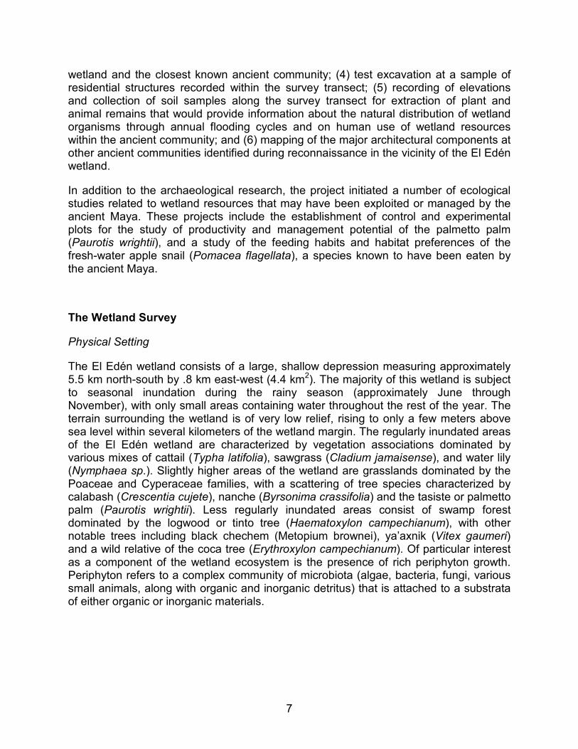
Figure 3. Archaeological survey within the El Edén wetland.
Figure 4. Mapping a rock alignment in the El Edén wetland.
9
Methods
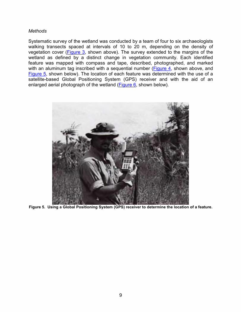
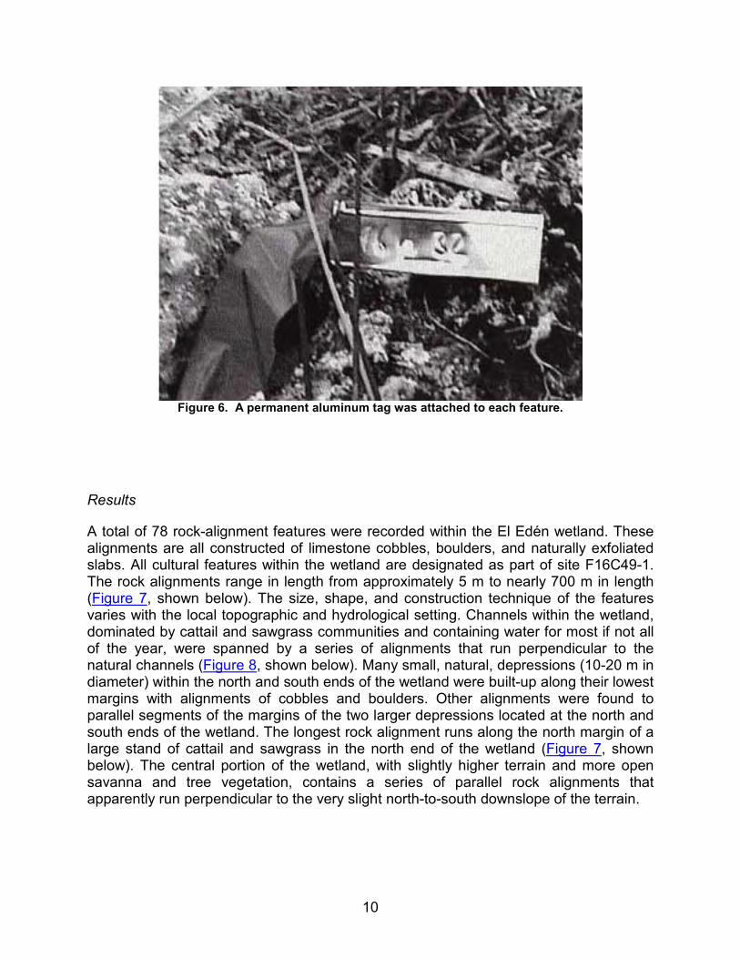
Systematic survey of the wetland was conducted by a team of four to six archaeologists walking transects spaced at intervals of 10 to 20 m, depending on the density of vegetation cover (Figure 3, shown above). The survey extended to the margins of the wetland as defined by a distinct change in vegetation community. Each identified feature was mapped with compass and tape, described, photographed, and marked with an aluminum tag inscribed with a sequential number (Figure 4, shown above, and Figure 5, shown below). The location of each feature was determined with the use of a satellite-based Global Positioning System (GPS) receiver and with the aid of an enlarged aerial photograph of the wetland (Figure 6, shown below).
Figure 5. Using a Global Positioning System (GPS) receiver to determine the location of a feature.
10
Figure 6. A permanent aluminum tag was attached to each feature.
Results
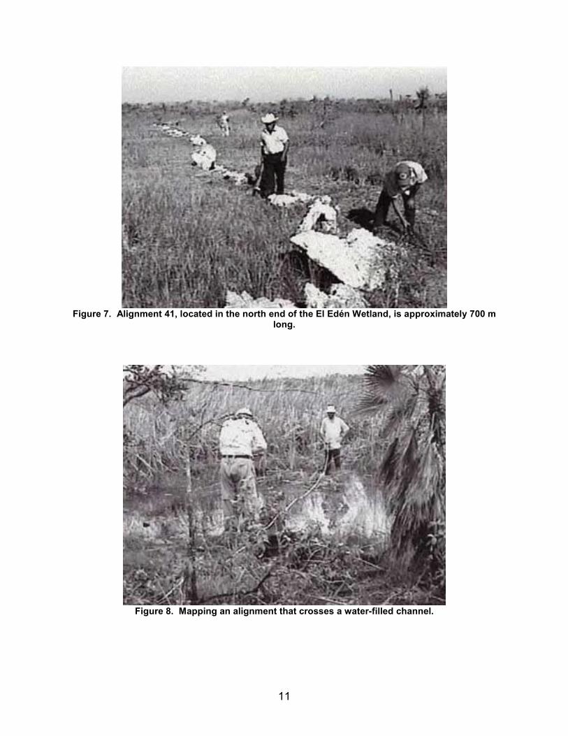
A total of 78 rock-alignment features were recorded within the El Edén wetland. These alignments are all constructed of limestone cobbles, boulders, and naturally exfoliated slabs. All cultural features within the wetland are designated as part of site F16C49-1. The rock alignments range in length from approximately 5 m to nearly 700 m in length (Figure 7, shown below). The size, shape, and construction technique of the features varies with the local topographic and hydrological setting. Channels within the wetland, dominated by cattail and sawgrass communities and containing water for most if not all of the year, were spanned by a series of alignments that run perpendicular to the natural channels (Figure 8, shown below). Many small, natural, depressions (10-20 m in diameter) within the north and south ends of the wetland were built-up along their lowest margins with alignments of cobbles and boulders. Other alignments were found to parallel segments of the margins of the two larger depressions located at the north and south ends of the wetland. The longest rock alignment runs along the north margin of a large stand of cattail and sawgrass in the north end of the wetland (Figure 7, shown below). The central portion of the wetland, with slightly higher terrain and more open savanna and tree vegetation, contains a series of parallel rock alignments that apparently run perpendicular to the very slight north-to-south downslope of the terrain.
11
Figure 7. Alignment 41, located in the north end of the El Edén Wetland, is approximately 700 m
long.
Figure 8. Mapping an alignment that crosses a water-filled channel.
12
In addition to the rock-alignment features, two possible animal traps constructed of limestone boulders were recorded within the higher terrain in the central portion of the wetland, and two possible structures were recorded at the southwest margin of the wetland.
Test Excavation at Wetland Features
Methods
Test excavation of a sample of rock alignments was intended to provide information on construction techniques and to recover artifacts and samples that would provide data on dating and function of the features. Four alignments were selected for excavation, representing four of the five recognized types of features.
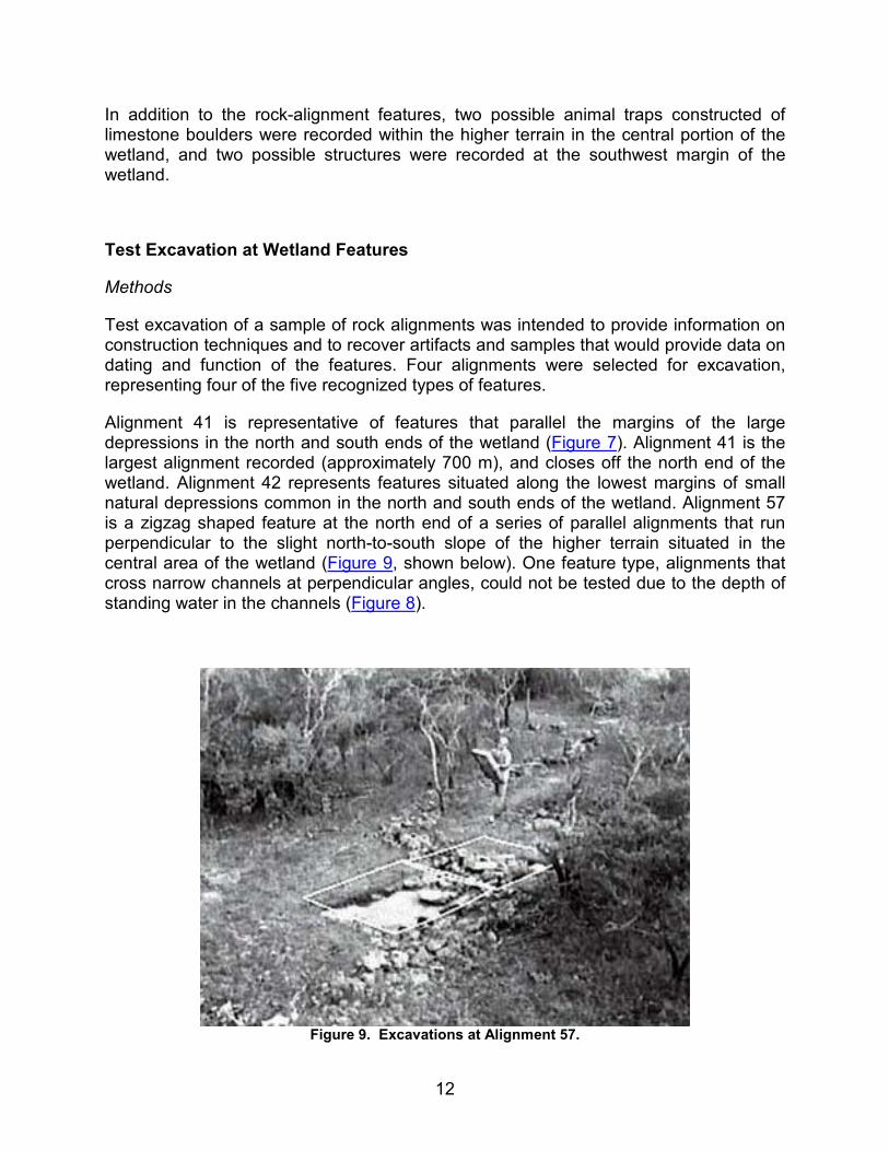
Alignment 41 is representative of features that parallel the margins of the large depressions in the north and south ends of the wetland (Figure 7). Alignment 41 is the largest alignment recorded (approximately 700 m), and closes off the north end of the wetland. Alignment 42 represents features situated along the lowest margins of small natural depressions common in the north and south ends of the wetland. Alignment 57 is a zigzag shaped feature at the north end of a series of parallel alignments that run perpendicular to the slight north-to-south slope of the higher terrain situated in the central area of the wetland (Figure 9, shown below). One feature type, alignments that cross narrow channels at perpendicular angles, could not be tested due to the depth of standing water in the channels (Figure 8).
Figure 9. Excavations at Alignment 57.
13
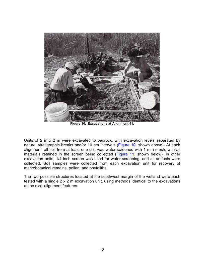
Figure 10. Excavations at Alignment 41.
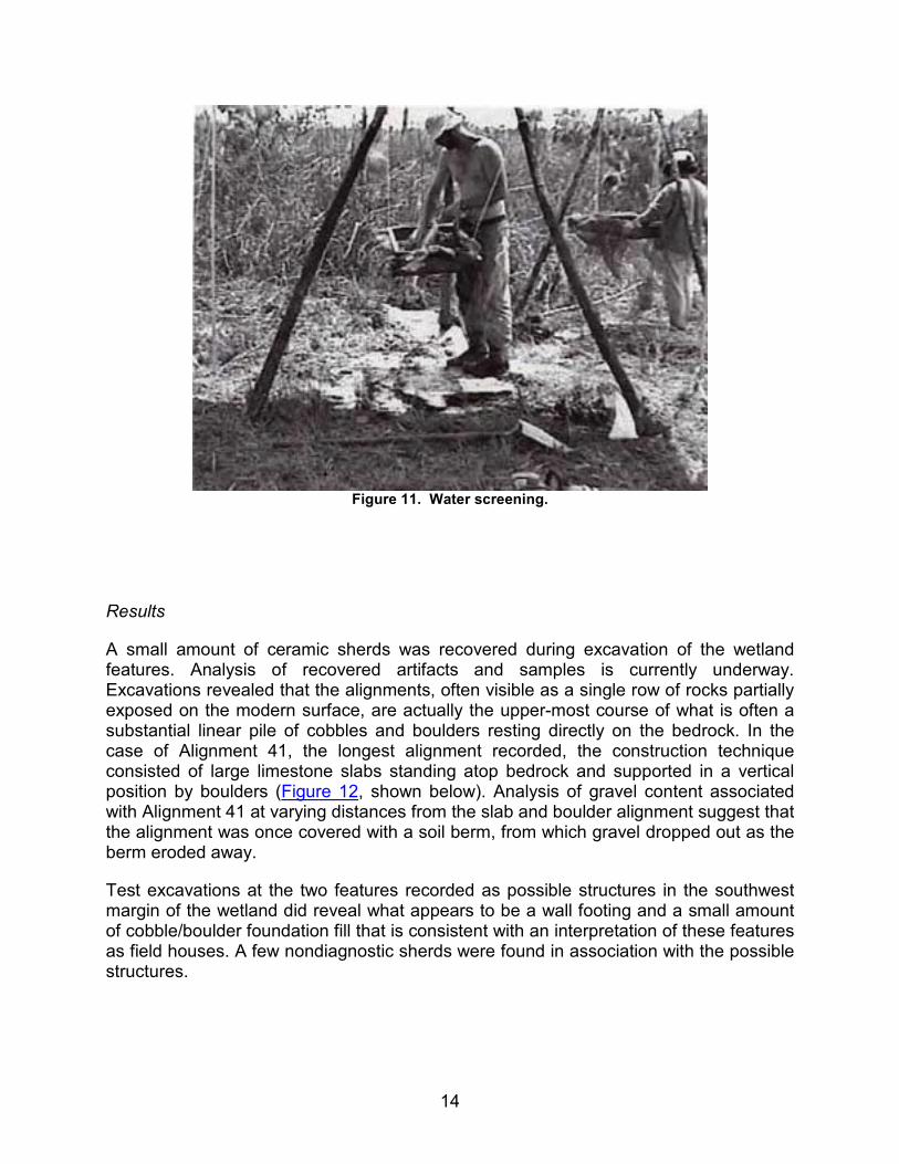
Units of 2 m x 2 m were excavated to bedrock, with excavation levels separated by natural stratigraphic breaks and/or 10 cm intervals (Figure 10, shown above). At each alignment, all soil from at least one unit was water-screened with 1 mm mesh, with all materials retained in the screen being collected (Figure 11, shown below). In other excavation units, 1/4 inch screen was used for water-screening, and all artifacts were collected. Soil samples were collected from each excavation unit for recovery of macrobotanical remains, pollen, and phytoliths.
The two possible structures located at the southwest margin of the wetland were each tested with a single 2 x 2 m excavation unit, using methods identical to the excavations at the rock-alignment features.
14
Figure 11. Water screening.
Results
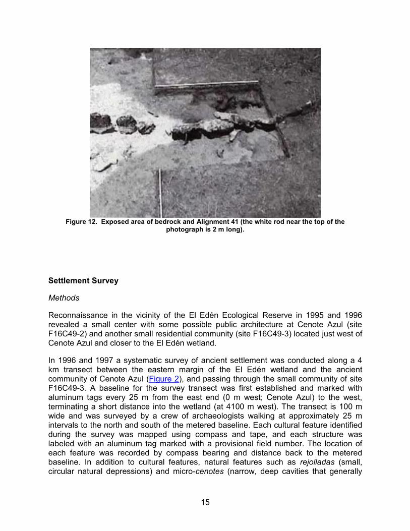
A small amount of ceramic sherds was recovered during excavation of the wetland features. Analysis of recovered artifacts and samples is currently underway. Excavations revealed that the alignments, often visible as a single row of rocks partially exposed on the modern surface, are actually the upper-most course of what is often a substantial linear pile of cobbles and boulders resting directly on the bedrock. In the case of Alignment 41, the longest alignment recorded, the construction technique consisted of large limestone slabs standing atop bedrock and supported in a vertical position by boulders (Figure 12, shown below). Analysis of gravel content associated with Alignment 41 at varying distances from the slab and boulder alignment suggest that the alignment was once covered with a soil berm, from which gravel dropped out as the berm eroded away.
Test excavations at the two features recorded as possible structures in the southwest margin of the wetland did reveal what appears to be a wall footing and a small amount of cobble/boulder foundation fill that is consistent with an interpretation of these features as field houses. A few nondiagnostic sherds were found in association with the possible structures.
15
Figure 12. Exposed area of bedrock and Alignment 41 (the white rod near the top of the
photograph is 2 m long).
Settlement Survey
Methods
Reconnaissance in the vicinity of the El Edén Ecological Reserve in 1995 and 1996 revealed a small center with some possible public architecture at Cenote Azul (site F16C49-2) and another small residential community (site F16C49-3) located just west of Cenote Azul and closer to the El Edén wetland.
In 1996 and 1997 a systematic survey of ancient settlement was conducted along a 4 km transect between the eastern margin of the El Edén wetland and the ancient community of Cenote Azul (Figure 2), and passing through the small community of site F16C49-3. A baseline for the survey transect was first established and marked with aluminum tags every 25 m from the east end (0 m west; Cenote Azul) to the west, terminating a short distance into the wetland (at 4100 m west). The transect is 100 m wide and was surveyed by a crew of archaeologists walking at approximately 25 m intervals to the north and south of the metered baseline. Each cultural feature identified during the survey was mapped using compass and tape, and each structure was labeled with an aluminum tag marked with a provisional field number. The location of each feature was recorded by compass bearing and distance back to the metered baseline. In addition to cultural features, natural features such as rejolladas (small, circular natural depressions) and micro-cenotes (narrow, deep cavities that generally

16
extend down to the water table) were also mapped. In order to record the full extent of community F16C49-3, an additional 100 meter-wide strip was surveyed on the south side of the original transect between 700 and 1500 m west of the Cenote Azul end of the baseline, as well as a 100 meter-wide strip north of the original transect between 0 m and 1500 m west.
Results
The systematic survey recorded the remains of 62 structures and numerous walls and wells clustered primarily within community F16C49-3. Walls appear to divide F16C49-3 into 5 compounds. In addition to the wells and micro-cenotes that could have supplied water for the community, a deep cenote recorded in the southeast portion of the community would have assured a constant water supply.
Test Excavations at Residential Sites
Methods
Of the 62 structures recorded during the systematic survey, 15 were selected for test excavation. In selecting the sample, the first step was to calculate the volume for each structure based on length, width, and height measurements. The 62 structures were then ranked by estimated volume into five classes: rank 1 (over 300 m2), rank 2 (151-300 m2), rank 3 (81-150 m2), rank 4 (51-80 m2), and rank 5 (1-50 m2). In addition, the geographic space of the F16C49-3 settlement was divided into five compounds, delineated by prehistoric walls. A sample was then selected to represent at least 20 percent of each size ranking, as well as 20 percent of each compound, making sure to select a range of sizes from within each compound whenever possible.
A total of 16 units was excavated in association with the structures (one structure received two excavation units), each measuring 1 x 2 m. Units were located just off the edge of structure mounds in areas where ceramics were visible on the ground surface. In addition, preference was given to locations apparently at the back of structures; for example, between a mound and a compound wall. Each unit was excavated to bedrock, which averaged only 20 cm below the modern surface. All soil was screened with 1/4 inch mesh, and all artifacts retained in the screen were collected. A two-liter soil sample was collected from each excavation unit-level for flotation analysis. Soil samples were also collected from each excavation context for recovery of pollen and phytoliths. In addition to the excavation units associated with structures, three rejolladas were tested using the same methods as applied to the structures. One of these tested rejolladas was directly associated with a group of structures within the F16C49-3 community, and the other two were located away from the immediate vicinity of the community.
17
Results
The test excavations produced a relatively small amount of ceramics (less than 20 ltr). Potentially diagnostic sherds from the 1996 excavations were examined by Sylviane Bucher of the Ceramiteca associated with the Mérida office of the Institute Nacional de Antropología e Historia. The identifiable ceramics were all assigned to the Late Preclassic period, with dates for ceramic types ranging from approximately 100 B.C. to A.D. 400. Ceramics from the 1997 excavations are yet to be analyzed, but on initial inspection appear to represent the same range of types as those from the 1996 excavations. Surprisingly, no lithic artifacts were recovered in either the 1996 or 1997 excavations. Small lithic debitage may be contained in the soil samples or water-screened material that is yet to be sorted.
Terrain and Soil Sampling Along the Survey Baseline
Methods
In addition to mapping cultural features along the survey transect, elevation measurements and soil samples were taken in order to determine the probable flood zone of the wetland and maximum dispersion of wetland fauna (e.g. snails) by flooding. Elevations also provide information on proximity to the watertable, a potential factor in the selection of areas for the excavation of wells. Elevations were measured relative to the recorded 1995 high-water mark, representing the deepest flooding of the El Edén wetland since the research station was established there in 1993. Elevation readings were taken every 25 m along the survey transect baseline using a transit and stadia rod. Soil samples were collected along the transect at intervals of approximately 100 m, with samples being collected from shallow depressions whenever present. Three samples were also collected from potential ancient garden areas as defined by walls within the F16C49-3 community. The uppermost few centimeters of organic matter and topsoil were first removed from a sample location. Soil was then collected and screened over a bucket with 1/2 inch mesh. Any shell, bone, or cultural material retained in the 1/2 inch mesh was added back into the collected sample. From the screened material, a 10 ltr bulk-sample was collected, as well as five 100 ml samples to be used for analysis of pollen, phytoliths, diatoms, and other micro-remains. After transport to the research station, the bulk samples were water-screened with 1 mm mesh, and all material retained in the screen was dried and prepared for analysis.
Results
While analysis of the elevation and soil sample data is underway, initial observations indicate that a rise in elevation between approximately 2700 and 3000 m west of Cenote Azul restricts the flood zone of the wetland and defines the farthest natural dispersion of aquatic snails. The F16C49-3 community is situated within a large, shallow, natural depression east of the rise.
18
Reconnaissance and Mapping in the El Edén Area
Methods
Within the El Edén reserve, general reconnaissance by a variety of researchers has taken place since the research station was founded in 1993. While the systematic archaeological survey of 1996-97 covered the wetland in its entirety, many areas beyond the wetland margin were also informally inspected. All trails throughout the reserve have been walked by archaeologists. In addition, the land around each cenote and large wetland depression located outside of the wetland proper but within the boundary of the reserve was examined by cutting 8 regularly spaced trails radiating out from the cenote or depression for a distance of 100 meters.
The vicinity around the El Edén reserve has had reconnaissance conducted along existing roads and trails. Archaeologists have also made use of interviews with local residents in an attempt to locate any sites noted by hunters or farmers during ventures into the forest.
Results
Reconnaissance has not identified any structural remains within the boundaries of the El Edén reserve (although 2 possible structures were recorded on the margin of the wetland during the systematic survey). Within an 8 km radius of the reserve, reconnaissance resulted in the recording of five ancient communities that include apparent public architecture or elite residential structures in addition to the remains of numerous smaller residential structures. These sites are Rancho Carmelita, Cenote Azul, the Wasp Site, Rancho Santa Maria, and Yax Mesh. A preliminary map of each site was produced using compass and tape or pace, and site locations were determined with use of a GPS receiver. All sites recorded during the project will be registered with the central office of the Institute de Antropología e Historia (INAH) in México City and with the Quintana Roo state office of INAH in Chetumal.
Interpretations
Our archaeological investigations of 1996-97 clearly indicate that the wetland within the El Edén Ecological Reserve was managed by the ancient Maya. This management, indicated by the 78 recorded rock-alignment features, most probably took place during the time that the nearby settlements were occupied; from approximately 100 B.C. to A.D. 400. Our observations indicate that wetland management strategies at El Edén differed from those that have been documented or suggested for other areas of the Maya Lowlands. Investigations of wetlands in the southern lowlands suggest that the most common form of wetland manipulation was by channeling the seasonally

19
inundated margins of wetlands, with perhaps some construction of raised planting beds or use of natural hummocks within the more regularly flooded zones. So far, neither of these strategies is evident at El Edén. In the study area, channelization of the wetland margins in order to facilitate drainage would not have been practical, as the margins were for the most part either exposed bedrock or very thin soil over bedrock. No raised platforms have been identified at El Edén, although their existence cannot be ruled out for other wetlands of the Yalahau region.
The features constructed within the El Edén wetland most likely were intended to control water movement and soil deposition during annual flooding cycles. The rock alignments visible today are probably the structural cores of earthen berms that have eroded away over the last 1,500 years. We have developed a number of working hypotheses regarding the resources that may have been cultivated or managed within the wetland, and it is anticipated that our ongoing analyses will result in the conclusive testing of some of these ideas. Given that several varieties of rock-alignment features were recorded in varying physical settings, it is likely that the different features functioned in different ways.
One hypothetical function for many, if not all, of the features would be as soil and water control devices incorporated into an intensive form of water-recessional cultivation of domesticated crops. Various forms of water-recessional cultivation are known ethnographically for the Maya Lowlands (Carter, 1969; Culbert, 1978; Gliessman, 1991; Wilk, 1985). Under these cultivation systems, the farmer plants in the moist soils that are exposed as waters recede during the dry season along the margins of rivers or wetlands. None of the ethnographic examples mention intensification through the construction of rock alignments. As an intensified variation of water-recessional cultivation, the construction of rock alignments could have functioned to help retain soils and moisture, thereby increasing the productivity of the naturally thin soils and lengthening the growing season. At the El Edén wetland, crops could have been planted in sequence behind the alignments as the waters receded at the end of the rainy season. According to this hypothesis, the use of wetlands at El Edén would represent an intensified form of an ethnographically known cultivation system. Analysis of pollen and phytolith samples collected during the project should identify the presence of domestic species such as maize or cotton if they had been cultivated in the wetland. Control samples taken from upland areas adjacent to the wetland will help to investigate the possibility that pollen and phytoliths found in the wetland samples could have been washed into the depression from fields situated on higher ground.
The second hypothetical function of the rock alignments is associated with what can be termed the "fertilizer factory" hypothesis. Dr. Ana Luisa Anaya of the National Autonomous University of México has collected and analyzed samples of periphyton from the El Edén wetland. This periphyton, composed primarily of various species of algae, represents a vital component of freshwater wetland ecosystems. Periphyton provides the main source of food for many grazing herbivores and contributes significantly to the cycling of nutrients, particularly nitrogen and phosphorus. Dr. Anaya’s analyses indicate very high levels of phosphorus, nitrogen, and organic matter, as well as a high cation exchange capacity – all indicators of high fertility from the perspective
20
of plant growth. Moreover, phosphorus is the primary limiting nutrient for agriculture in the Yucatán Peninsula. Thus, the periphyton may represent a formerly unrecognized (by modern researchers) source of natural agricultural fertilizer that may have been exploited by the ancient Maya. The extensive, thick, and fast-growing periphyton could have been harvested and transported to intensively cultivated gardens. Some of the rock alignments at El Edén could have functioned to retain water longer into the dry season, thereby increasing periphyton growth and facilitating its collection from behind the features. Ongoing studies by several Mexican colleagues are defining the hydrological settings and ecosystems preferred by periphyton communities, which may in turn suggest management strategies that could have been used by the ancient Maya to increase periphyton growth. The soil samples collected from lands in and around the ancient Maya community situated east of the wetland should help determine if periphyton was used as a fertilizer in community gardens, as would be indicated by the presence of diatoms and minute shells from wetland species of gastropods that form part of the periphyton community.
In addition to the potential use of the wetlands for the cultivation of domestic crops or for cultivation of periphyton as a fertilizer, the recorded features may be related to the management of a number of edible wetland resources. The most abundant of these resources are cattails, blue-green algae, and apple snails. The cattails (Typha latifolia) that grow abundantly within the deeper areas of the wetland represent a potentially significant food source. Referred to as "probably the most famous of all the edible plants of the Northern Hemisphere" (Harrington, 1967:220), virtually all parts of the common cattail are edible and are used as food in many parts of the world (Morton, 1975). The cattail rootstock or rhizome in particular is highly nutritious, containing as much protein as maize and more carbohydrates than the potato (Morton, 1975:23). Blue-green algae, a major component of the periphyton of the Yalahau wetlands, is another potential food source worth considering. A number of blue-green algae species are known to have been used as a food by the Aztec and Inca peoples of the Americas (Coe, 1994:100-101, 186). The apple snail (Pomacea flagellata), a large edible fresh-water snail is abundant in the Yalahau wetlands, and is known to have been a significant food source to the ancient Maya (e.g. Andrews, 1969; Moholy-Nagy, 1978). All of these resources –cattail, blue-green algae, and apple snails– are responsive to varying hydrologic regimes. Manipulation of hydro-period (length of time flooded during the year) and water depth may have been accomplished through construction of the features recorded in the El Edén wetland.
The settlement history of the El Edén area presents an interesting anomaly. The ceramics that have been analyzed so far indicate occupation of the area only during the Late Preclassic period, between approximately 100 B.C. and 400 A.D. The sparse evidence for Classic period occupation within the Yalahau region in general has been noted (Fedick and Taube, 1995), but it is unusual to also have a lack of evidence for a Late Postclassic presence, which is rather common in the rest of the region. Whether this settlement history is associated with environmental changes that may have rendered the wetlands unsuitable for manipulation after the Preclassic period, or may be due to some social or economic upheaval that resulted in the abandonment of the area, is currently unknown. In either case, the El Edén wetland does provide the first
21
documented evidence for wetland management in the northern Maya Lowlands, and supports the argument for Preclassic use of wetlands by the ancient Maya.
Acknowledgments
The 1996-97 research of the Yalahau Regional Human Ecology Project was conducted under permit of the Institute Nacional de Antropología e Historia (INAH), and with the approval of the Consejo Supremo Maya Norte de Quintana Roo. We are grateful for the assistance of Ing. Joaquín García-Bárcena, current President of the Consejo de Arqueología, and Arqlgo. Noberto González Crespo, past President of the Consejo, for their assistance in the permit process, and to INAH archaeologists Sylviane Boucher, Maria José Con Uribe, Luis Leira, Sara Novela, Fernando Robles Castellanos, Enrique Terrones, and Adriana Velázquez Morlet for their assistance and interest in our project. Initial analysis of ceramics for the project was kindly provided by Sylviane Boucher with the assistance of Sara Dzul G. C. Fidel Baas Chuc, President of the Consejo Supremo Maya Norte de Quintana Roo, facilitated our research in the region by serving as liaison with local communities. Our work at the El Edén Ecological Reserve was greatly facilitated by Marco Lazcano, Arturo Gómez-Pompa, and the staff of the reserve.
Assistance in the field was provided by enthusiastic, hard working and efficient crew members Bente Juhl Anderson, Daniel Baum, Ross Curtis, Aaron Gardner, Natasha Johnson, Carrie Lambert, Aline Mangoni, Rani McLean, Ivan Miranda, Shanti Morell-Hart, Matthew Moriarty, Brenda Smith, Cameron Walker, and Darcy Wiewall, as well as University Research Expeditions project participants Emily Chargin, Paula Chidichimo, Dawn Digrius, Richard Hall, Jana Kattenhorn, Preety Ranchod, Enid and Martin Rosenfeldt, Sara McCann, and Jennifer Weinstein.
The 1996-97 seasons of field research at El Edén were supported by grants from the UC MEXUS program of the University of California, the Foundation for the Advancement of Mesoamerican Studies, Inc., and the University Research Expeditions Program of the University of California.
List of Figures
Figure 1. Map of the Maya area showing natural regions, modern political divisions, and the location of the Yalahau region.
Figure 2. Map showing the wetlands of Yalahau region (in black) and the location of archaeological sites (triangles) mentioned in the text.
Figure 3. Archaeological survey within the El Edén wetland.
Figure 4. Mapping a rock alignment in the El Edén wetland.
22
Figure 5. Using a Global Positioning System (GPS) receiver to determine the location of a feature.
Figure 6. A permanent aluminum tag was attached to each feature.
Figure 7. Alignment 41, located in the north end of the El Edén Wetland, is approximately 700 m long.
Figure 8. Mapping an alignment that crosses a water-filled channel.
Figure 9. Excavations at Alignment 57.
Figure 10. Excavations at Alignment 41.
Figure 11. Water screening.
Figure 12. Exposed area of bedrock and Alignment 41 (the white rod near the top of the photograph is 2 m long).
Sources Cited
Andrews, Anthony P.
1985 The Archaeology and History of Northern Quintana Roo. In Geology and Hydrogeology of the Yucatán and Quaternary Geology of the Northeastern Yucatán Peninsula, edited by W.C. Ward, A.E. Weidie, and W. Black, pp. 127-143. New Orleans Geological Society, New Orleans.
Andrews, E. Wyllys IV
1969 The Archaeological Use and Distributions of Mollusca in the Maya Lowlands. Middle American Research Institute, Publication 34. Tulane University, New Orleans.
Carter, William E.
1969 New Lands and Old Traditions: Kekchi Cultivators in the Guatemalan Lowlands. University of Florida Press, Gainsville.
Coe, Sophie D.
1994 America’s First Cuisines. University of Texas Press, Austin
23
Culbert, T. Patrick, Pamela C. Magers, and Mara L. Spencer
1978 Regional Variability in Maya Lowland Agriculture. In Pre-Hispanic Maya Agriculture, edited by Peter D. Harrison and B.L. Turner II, pp. 157-161. University of New Mexico Press, Albuquerque.
Culbert, T. Patrick, Laura J. Levi, and Luis Cruz
1990 Lowland Maya Wetland Agriculture: The Río Azul Agronomy Program. In Vision and Revision in Maya Studies, edited by Flora S. Clancy and Peter D. Harrison, pp. 115-124. University of New Mexico Press, Albuquerque.
Fedick, Scott L.
1995 Observations on Archaeological Features Within a Wetland of the El Edén Ecological Reserve, Northern Quintana Roo, México. Report on file with the Institute Nacional de Antropología e Historia, Cancún and México D.F. offices
1996a New Perspectives on Ancient Maya Agriculture and Resource Use. In The Managed Mosaic: Ancient Maya Agriculture and Resource Management, edited by Scott L. Fedick, pp. 1-14. University of Utah Press, Salt Lake City.
Fedick, Scott L. (editor)
1996b The Managed Mosaic: Ancient Maya Agriculture and Resource Management. University of Utah Press, Salt Lake City.
Fedick, Scott L., and Anabel Ford
1990 The Prehistoric Agricultural Landscape of the Central Maya Lowlands: An Examination of Local Variability in a Regional Context. World Archaeology 22:18-33.
Fedick, Scott L., and Kevin Hovey
1995 Ancient Maya Settlement and Use of Wetlands at Naranjal and the Surrounding Yalahau Region. In The View from Yalahau: 1993 Archaeological Investigations in Northern Quintana Roo, México, edited by Scott L. Fedick and Karl A. Taube, pp. 89-100. Latin American Studies Program, Field Report Series No. 2., University of California, Riverside.
Fedick, Scott L., and Karl A. Taube (editors)
1995 The View from Yalahau: 1993 Archaeological Investigations in Northern Quintana Roo, México. Latin American Studies Program, Field Report Series No. 2., University of California, Riverside.
24
Gliessman, Stephen R.
1991 Ecological Basis of Traditional Management of Wetlands in Tropical México: Learning from Agroecosystems. In Biodiversity: Culture, Conservation, and Ecodevelopment, edited by Margery L. Oldfield and Janis B. Alcorn, pp. 211-229. Westview Press, Boulder.
Harrington, H.D.
1967 Edible Native Plants of the Rocky Mountains. University of New Mexico Press, Albuquerque.
Harrison, Peter D., and B.L. Turner II (editors)
1978 Pre-Hispanic Maya Agriculture. University of New Mexico Press, Albuquerque.
Isphording, W.C.
1975 The Physical Geology of Yucatán. Transactions, Gulf Coast Association of Geological Societies 25:231-262.
Moholy-Nagy, Hattula
1978 The Utilization Of Pomacea Snails at Tikal, Guatemala. American Antiquity 43:65-73.
Morton, Julia F.
1975 Cattails (Typha spp.) - Weed Problems or Potential Crop? Economic Botany 29:7-30.
Pohl, Mary D., Kevin 0. Pope, John G. Jones, Dolores R. Piperno, Susan D. deFrance, David L. Lentz, John A. Gifford, Marie E. Danforth, and Kathryn Josserand
1996 Early Agriculture in the Maya Lowlands. Latin American Antiquity 7:355-372.
Pope, Kevin 0., and Bruce Dahlin
1989 Ancient Maya Wetland Agriculture: New Insights from Ecological and Remote Sensing Research. Journal of Field Archaeology 16:87-106.
Southworth, C. Scott
1985 Applications of Remote-Sensing Data, Eastern Yucatán. In Geology and Hydrogeology of the Yucatán and Quaternary Geology of Northeastern Yucatán Peninsula, by W.C. Ward, A.E. Weidie, and W. Back, pp. 12-18. New Orleans Geological Society Publications, New Orleans.
Tulaczyk, Slawomir M.
1993 Karst Geomorphology and Hydrogeology of the Northeastern Yucatán Peninsula, México. Unpublished Master’s Thesis, Department of Geology, Northern Illinois University.
25
Turner, B.L. II
1993 Rethinking the "New Orthodoxy": Interpreting Ancient Maya Agriculture and Environment. In Culture, Form, and Place: Essays in Cultural and Historical Geography, edited by Kent Mathewson, pp. 57-88. Geoscience and Man, vol.32. Geoscience Publications, Department of Geography and Anthropology, Louisiana State University, Baton Rouge.
Turner, B.L. II, and Peter D. Harrison (editors)
1983 Pulltrouser Swamp: Ancient Maya Habitat, Agriculture, and Settlement in Northern Belize. University of Texas Press, Austin.
Weidie, A.E.
1985 Geology of Yucatán Platform. In Geology and Hydrogeology of the Yucatán and Quaternary Geology of Northeastern Yucatán Peninsula, by W.C. Ward, A.E. Weidie, and W. Back, pp. 1-19. New Orleans Geological Society Publications, New Orleans.
Wilk, Richard R.
1985 Dry Season Agriculture Among the Kekchi Maya and its Implications for Prehistory. In Prehistoric Lowland Maya Environment and Subsistence, edited by Mary Pohl, pp. 47-57. Papers of the Peabody Museum of Archaeology and Ethnology, vol. 77. Harvard University Press, Cambridge.