annex 3 to the convention on international civil … 3...meteorological service for international...
TRANSCRIPT

Meteorological Servicefor InternationalAir Navigation
Meteorological Servicefor InternationalAir Navigation
Annex 3to the Convention onInternational Civil Aviation
Annex 3to the Convention onInternational Civil Aviation
This edition incorporates all amendmentsadopted by the Council prior to 2 February 20 0and supersedes, on November 20 0, all previouseditions of Annex 3.
For information regarding the applicabilityof Standards and Recommended Practices,
Foreword.see
3 118 1
International Civil Aviation OrganizationInternational Civil Aviation Organization
International Standards
and Recommended Practices
International Standards
and Recommended Practices
Seventeenth EditionJuly 2010
Part ICore SARPs
Part IIAppendices and Attachments
Part ICore SARPs
Part IIAppendices and Attachments

�������

International Standards and Recommended Practices
This edition incorporates all amendments adopted by the Council prior to 23 February 2010 and supersedes, on 18 November 2010, all previous editions of Annex 3. For information regarding the applicability of the Standards and Recommended Practices, see Foreword.
Seventeenth Edition July 2010
International Civil Aviation Organization
Meteorological Service for International Air Navigation
________________________________
Annex 3 to the Convention on International Civil Aviation
Part I Core SARPs Part II Appendices and Attachments

Published in separate English, Arabic, Chinese, French, Russian and Spanish editions by the INTERNATIONAL CIVIL AVIATION ORGANIZATION 999 University Street, Montréal, Quebec, Canada H3C 5H7 For ordering information and for a complete listing of sales agents and booksellers, please go to the ICAO website at www.icao.int First edition 1948 Sixteenth edition 2007 Seventeenth edition 2010 Annex 3, Meteorological Service for International Air Navigation Order Number: AN 3 ISBN 978-92-9231-507-8 © ICAO 2010 All rights reserved. No part of this publication may be reproduced, stored in a retrieval system or transmitted in any form or by any means, without prior permission in writing from the International Civil Aviation Organization.
(iii)
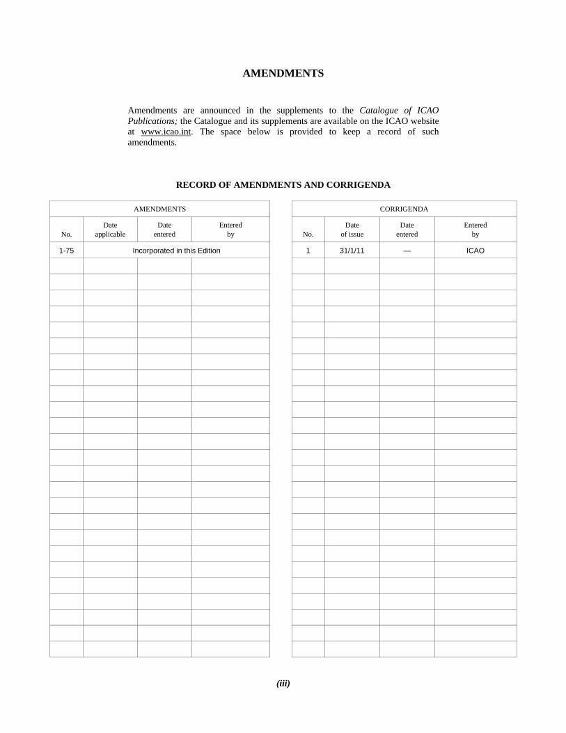
AMENDMENTS
Amendments are announced in the supplements to the Catalogue of ICAO Publications; the Catalogue and its supplements are available on the ICAO website at www.icao.int. The space below is provided to keep a record of such amendments.
RECORD OF AMENDMENTS AND CORRIGENDA
AMENDMENTS CORRIGENDA
No. Date
applicable Date
entered Entered
by No. Date
of issue Date
entered Entered
by
1-75 Incorporated in this Edition 1 31/1/11 — ICAO


ANNEX 3 (v) 18/11/10
TABLE OF CONTENTS
Page FOREWORD ......................................................................................................................................................... (ix)
PART I. CORE SARPs CHAPTER 1. Definitions ................................................................................................................................. 1-1 1.1 Definitions .......................................................................................................................................... 1-1 1.2 Terms used with a limited meaning .................................................................................................... 1-7 CHAPTER 2. General provisions .................................................................................................................... 2-1 2.1 Objective, determination and provision of meteorological service ..................................................... 2-1 2.2 Supply, use and quality management of meteorological information ................................................. 2-2 2.3 Notifications required from operators ................................................................................................. 2-3 CHAPTER 3. World area forecast system and meteorological offices ........................................................ 3-1 3.1 Objective of the world area forecast system ....................................................................................... 3-1 3.2 World area forecast centres................................................................................................................. 3-1 3.3 Meteorological offices ........................................................................................................................ 3-2 3.4 Meteorological watch offices .............................................................................................................. 3-3 3.5 Volcanic ash advisory centres ............................................................................................................. 3-4 3.6 State volcano observatories ................................................................................................................ 3-4 3.7 Tropical cyclone advisory centres ...................................................................................................... 3-5 CHAPTER 4. Meteorological observations and reports ............................................................................... 4-1 4.1 Aeronautical meteorological stations and observations ...................................................................... 4-1 4.2 Agreement between air traffic services authorities and meteorological authorities ............................ 4-2 4.3 Routine observations and reports ........................................................................................................ 4-2 4.4 Special observations and reports ......................................................................................................... 4-3 4.5 Contents of reports .............................................................................................................................. 4-3 4.6 Observing and reporting meteorological elements ............................................................................. 4-4 4.7 Reporting meteorological information from automatic observing systems ........................................ 4-6 4.8 Observations and reports of volcanic activity ..................................................................................... 4-6 CHAPTER 5. Aircraft observations and reports ........................................................................................... 5-1 5.1 Obligations of States ........................................................................................................................... 5-1 5.2 Types of aircraft observations ............................................................................................................. 5-1 5.3 Routine aircraft observations — designation ...................................................................................... 5-1

Annex 3 — Meteorological Service for International Air Navigation Table of Contents
Page
18/11/10 (vi)
5.4 Routine aircraft observations — exemptions ...................................................................................... 5-1 5.5 Special aircraft observations ............................................................................................................... 5-2 5.6 Other non-routine aircraft observations .............................................................................................. 5-2 5.7 Reporting of aircraft observations during flight ................................................................................. 5-2 5.8 Relay of air-reports by ATS units ....................................................................................................... 5-2 5.9 Recording and post-flight reporting of aircraft observations of volcanic activity .............................. 5-3 CHAPTER 6. Forecasts .................................................................................................................................... 6-1 6.1 Interpretation and use of forecasts ...................................................................................................... 6-1 6.2 Aerodrome forecasts ........................................................................................................................... 6-1 6.3 Landing forecasts ................................................................................................................................ 6-2 6.4 Forecasts for take-off .......................................................................................................................... 6-2 6.5 Area forecasts for low-level flights..................................................................................................... 6-3 CHAPTER 7. SIGMET and AIRMET information, aerodrome warnings and wind shear warnings and alerts ................................................................................................................... 7-1 7.1 SIGMET information .......................................................................................................................... 7-1 7.2 AIRMET information ......................................................................................................................... 7-1 7.3 Aerodrome warnings .......................................................................................................................... 7-2 7.4 Wind shear warnings and alerts .......................................................................................................... 7-2 CHAPTER 8. Aeronautical climatological information ................................................................................ 8-1 8.1 General provisions .............................................................................................................................. 8-1 8.2 Aerodrome climatological tables ........................................................................................................ 8-1 8.3 Aerodrome climatological summaries ................................................................................................ 8-1 8.4 Copies of meteorological observational data ...................................................................................... 8-2 CHAPTER 9. Service for operators and flight crew members ..................................................................... 9-1 9.1 General provisions .............................................................................................................................. 9-1 9.2 Briefing, consultation and display ...................................................................................................... 9-2 9.3 Flight documentation .......................................................................................................................... 9-3 9.4 Automated pre-flight information systems for briefing, consultation, flight planning and flight documentation .................................................................................................................... 9-4 9.5 Information for aircraft in flight ......................................................................................................... 9-4 CHAPTER 10. Information for air traffic services, search and rescue services and aeronautical information services ............................................................................................................................................. 10-1 10.1 Information for air traffic services units ............................................................................................. 10-1 10.2 Information for search and rescue services units ................................................................................ 10-1 10.3 Information for aeronautical information services units ..................................................................... 10-1 CHAPTER 11. Requirements for and use of communications ..................................................................... 11-1 11.1 Requirements for communications ..................................................................................................... 11-1 11.2 Use of aeronautical fixed service communications and the public Internet — meteorological bulletins ...................................................................................................................... 11-2

Table of Contents Annex 3 — Meteorological Service for International Air Navigation
Page
(vii) 18/11/10
11.3 Use of aeronautical fixed service communications — world area forecast system products .............. 11-2 11.4 Use of aeronautical mobile service communications .......................................................................... 11-2 11.5 Use of aeronautical data link service — contents of D-VOLMET ..................................................... 11-2 11.6 Use of aeronautical broadcasting service — contents of VOLMET broadcasts ................................. 11-3
PART II. APPENDICES AND ATTACHMENTS
APPENDICES APPENDIX 1. Flight documentation — model charts and forms ................................................................ APP 1-1 APPENDIX 2. Technical specifications related to world area forecast system and meteorological offices .......................................................................................................................................... APP 2-1 1. World area forecast system ................................................................................................................. APP 2-1 2. Meteorological offices ........................................................................................................................ APP 2-4 3. Volcanic ash advisory centres (VAAC) .............................................................................................. APP 2-4 4. State volcano observatories ................................................................................................................ APP 2-5 5. Tropical cyclone advisory centres (TCAC) ........................................................................................ APP 2-5 APPENDIX 3. Technical specifications related to meteorological observations and reports .................... APP 3-1 1. General provisions related to meteorological observations ................................................................ APP 3-1 2. General criteria related to meteorological reports ............................................................................... APP 3-1 3. Dissemination of meteorological reports ............................................................................................ APP 3-4 4. Observing and reporting of meteorological elements ......................................................................... APP 3-5 APPENDIX 4. Technical specifications related to aircraft observations and reports ................................ APP 4-1 1. Contents of air-reports ........................................................................................................................ APP 4-1 2. Criteria for reporting ........................................................................................................................... APP 4-3 3. Exchange of air-reports ....................................................................................................................... APP 4-4 4. Specific provisions related to reporting wind shear and volcanic ash ................................................ APP 4-5 APPENDIX 5. Technical specifications related to forecasts ......................................................................... APP 5-1 1. Criteria related to TAF ........................................................................................................................ APP 5-1 2. Criteria related to trend forecasts ........................................................................................................ APP 5-5 3. Criteria related to forecasts for take-off .............................................................................................. APP 5-8 4. Criteria related to area forecasts for low-level flights ......................................................................... APP 5-8 APPENDIX 6. Technical specifications related to SIGMET and AIRMET information, aerodrome warnings and wind shear warnings and alerts .................................................................................................. APP 6-1 1. Specifications related to SIGMET information .................................................................................. APP 6-1 2. Specifications related to AIRMET information .................................................................................. APP 6-2 3. Specifications related to special air-reports ........................................................................................ APP 6-4 4. Detailed criteria related to SIGMET and AIRMET messages and special air-reports (uplink) .............................................................................................................................. APP 6-4

Annex 3 — Meteorological Service for International Air Navigation Table of Contents
Page
18/11/10 (viii)
5. Specifications related to aerodrome warnings .................................................................................... APP 6-5 6. Specifications related to wind shear warnings .................................................................................... APP 6-6 APPENDIX 7. Technical specifications related to aeronautical climatological information ..................... APP 7-1 1. Processing of aeronautical climatological information ....................................................................... APP 7-1 2. Exchange of aeronautical climatological information ........................................................................ APP 7-1 3. Content of aeronautical climatological information ........................................................................... APP 7-1 APPENDIX 8. Technical specifications related to service for operators and flight crew members .......... APP 8-1 1. Means of supply and format of meteorological information .............................................................. APP 8-1 2. Specifications related to information for pre-flight planning and in-flight re-planning ..................... APP 8-1 3. Specifications related to briefing and consultation ............................................................................. APP 8-2 4. Specifications related to flight documentation .................................................................................... APP 8-2 5. Specifications related to automated pre-flight information systems for briefing, consultation, flight planning and flight documentation ........................................................ APP 8-5 6. Specifications related to information for aircraft in flight .................................................................. APP 8-5 APPENDIX 9. Technical specifications related to information for air traffic services, search and rescue services and aeronautical information services .............................................................................. APP 9-1 1. Information to be provided for air traffic services units ..................................................................... APP 9-1 2. Information to be provided for search and rescue services units ........................................................ APP 9-3 3. Information to be provided for aeronautical information services units ............................................. APP 9-3 APPENDIX 10. Technical specifications related to requirements for and use of communications ........... APP 10-1 1. Specific requirements for communications ........................................................................................ APP 10-1 2. Use of aeronautical fixed service communications and the public Internet ........................................ APP 10-2 3. Use of aeronautical mobile service communications .......................................................................... APP 10-3 4. Use of aeronautical data link service — D-VOLMET........................................................................ APP 10-3 5. Use of aeronautical broadcasting service — VOLMET broadcasts ................................................... APP 10-4
ATTACHMENTS ATTACHMENT A. Operationally desirable accuracy of measurement or observation ........................... ATT A-1 ATTACHMENT B. Operationally desirable accuracy of forecasts ............................................................. ATT B-1 ATTACHMENT C. Selected criteria applicable to aerodrome reports ...................................................... ATT C-1 ATTACHMENT D. Conversion of instrumented readings into runway visual range and visibility ........ ATT D-1
___________________

ANNEX 3 (ix) 18/11/10
FOREWORD
Historical background Standards and Recommended Practices relating to meteorology were first adopted by the Council on 16 April 1948, pursuant to the provisions of Article 37 of the Convention on International Civil Aviation (Chicago, 1944), and designated as Annex 3 to the Convention with the title Standards and Recommended Practices — Meteorological Codes. The Standards and Recommended Practices were based on recommendations of the Special Session of the Meteorology Division, held in September 1947. Table A shows the origin of subsequent amendments, together with a list of the principal subjects involved and the dates on which the Annex and the amendments were adopted or approved by the Council, when they became effective and when they became applicable.
Action by Contracting States Notification of differences. The attention of Contracting States is drawn to the obligation imposed by Article 38 of the Convention by which Contracting States are required to notify the Organization of any differences between their national regulations and practices and the International Standards contained in this Annex and any amendments thereto. Contracting States are invited to extend such notification to any differences from the Recommended Practices contained in this Annex, and any amendments thereto, when the notification of such differences is important for the safety of air navigation. Further, Contracting States are invited to keep the Organization currently informed of any differences which may subsequently occur, or of the withdrawal of any differences previously notified. A specific request for notification of differences will be sent to Contracting States immediately after the adoption of each amendment to this Annex. Attention of States is also drawn to the provisions of Annex 15 related to the publication of differences between their national regulations and practices and the related ICAO Standards and Recommended Practices through the Aeronautical Information Service, in addition to the obligation of States under Article 38 of the Convention. Promulgation of information. The establishment and withdrawal of and changes to facilities, services and procedures affecting aircraft operations provided in accordance with the Standards and Recommended Practices specified in this Annex should be notified and take effect in accordance with the provisions of Annex 15. Use of the text of the Annex in national regulations. The Council, on 13 April 1948, adopted a resolution inviting the attention of Contracting States to the desirability of using in their own national regulations, as far as is practicable, the precise language of those ICAO Standards that are of a regulatory character and also of indicating departures from the Standards, including any additional national regulations that are important for the safety or regularity of air navigation. Wherever possible, the provisions of this Annex have been written in such a way as would facilitate incorporation, without major textual changes, into national legislation.
Status of Annex components An Annex is made up of the following component parts, not all of which, however, are necessarily found in every Annex; they have the status indicated:

Annex 3 — Meteorological Service for International Air Navigation Foreword
18/11/10 (x)
1.— Material comprising the Annex proper: a) Standards and Recommended Practices adopted by the Council under the provisions of the Convention. They
are defined as follows: Standard: Any specification for physical characteristics, configuration, matériel, performance, personnel or
procedure, the uniform application of which is recognized as necessary for the safety or regularity of international air navigation and to which Contracting States will conform in accordance with the Convention; in the event of impossibility of compliance, notification to the Council is compulsory under Article 38.
Recommended Practice: Any specification for physical characteristics, configuration, matériel, performance,
personnel or procedure, the uniform application of which is recognized as desirable in the interest of safety, regularity or efficiency of international air navigation, and to which Contracting States will endeavour to conform in accordance with the Convention.
b) Appendices comprising material grouped separately for convenience but forming part of the Standards and
Recommended Practices adopted by the Council. c) Definitions of terms used in the Standards and Recommended Practices which are not self-explanatory in that
they do not have accepted dictionary meanings. A definition does not have independent status but is an essential part of each Standard and Recommended Practice in which the term is used, since a change in the meaning of the term would affect the specification.
d) Tables and Figures which add to or illustrate a Standard or Recommended Practice and which are referred to
therein, form part of the associated Standard or Recommended Practice and have the same status. 2.— Material approved by the Council for publication in association with the Standards and Recommended Practices: a) Forewords comprising historical and explanatory material based on the action of the Council and including an
explanation of the obligations of States with regard to the application of the Standards and Recommended Practices ensuing from the Convention and the Resolution of Adoption;
b) Introductions comprising explanatory material introduced at the beginning of parts, chapters or sections of the
Annex to assist in the understanding of the application of the text; c) Notes included in the text, where appropriate, to give factual information or references bearing on the Standards
or Recommended Practices in question, but not constituting part of the Standards or Recommended Practices; d) Attachments comprising material supplementary to the Standards and Recommended Practices, or included as a
guide to their application.
Selection of language This Annex has been adopted in six languages — English, Arabic, Chinese, French, Russian and Spanish. Each Contracting State is requested to select one of those texts for the purpose of national implementation and for other effects provided for in the Convention, either through direct use or through translation into its own national language, and to notify the Organization accordingly.

Foreword Annex 3 — Meteorological Service for International Air Navigation
(xi) 18/11/10
Editorial practices The following practice has been adhered to in order to indicate at a glance the status of each statement: Standards have been printed in light face roman; Recommended Practices have been printed in light face italics, the status being indicated by the prefix Recommendation; Notes have been printed in light face italics, the status being indicated by the prefix Note. The following editorial practice has been followed in the writing of specifications: for Standards the operative verb “shall” is used, and for Recommended Practices the operative verb “should” is used. Any reference to a portion of this document, which is identified by a number, includes all subdivisions of the portion.
Applicability The Standards and Recommended Practices in this document govern the application of the Regional Supplementary Procedures (Doc 7030), in which document will be found statements of regional choices, where such options are permitted by this Annex.
Responsibility In accordance with a similar provision in the Foreword to Annex 6, Part II, the responsibility which devolves upon an operator, in accordance with the provisions of Annex 3, falls upon the pilot-in-command in the case of international general aviation.
Relation to corresponding WMO publications The regulatory material contained in Annex 3 is, except for a few minor editorial differences, identical with that appearing in the Technical Regulations (Chapter C.3.1) of the World Meteorological Organization (WMO). The aeronautical meteorological code forms referred to in Annex 3 are developed by the World Meteorological Organization on the basis of aeronautical requirements contained in this Annex, or stated from time to time by the Council. The aeronautical meteorological code forms are promulgated by WMO in its Publication No. 306 — Manual on Codes, Volume I.
Table A. Amendments to Annex 3
Amendment(s) Source(s) Subject(s)
Adopted/approved Effective
Applicable
1st Edition Second Session of the Meteorology Division
Meteorological codes for the transmission of meteorological information for aeronautical purposes.
16 April 1948 15 September 1948 11 January 1949
1 to 21 (2nd Edition)
Special Session of the Meteorology Division
Updating and improvement of meteorological codes. 17 September 1948 23 December 1948 11 January 1949
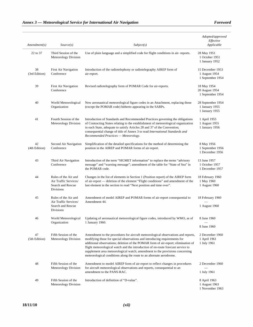
Annex 3 — Meteorological Service for International Air Navigation Foreword
18/11/10 (xii)
Amendment(s) Source(s) Subject(s)
Adopted/approved Effective
Applicable
22 to 37 Third Session of the Meteorology Division
Use of plain language and a simplified code for flight conditions in air- reports. 28 May 1951 11 October 1951 11 January 1952
38 (3rd Edition)
First Air Navigation Conference
Introduction of the radiotelephony or radiotelegraphy AIREP form of air-report.
15 December 1953 11 August 1954 11 September 1954
39 First Air Navigation Conference
Revised radiotelegraphy form of POMAR Code for air-reports. 18 May 1954 20 August 1954 11 September 1954
40 World Meteorological Organization
New aeronautical meteorological figure codes in an Attachment, replacing those (except the POMAR code) hitherto appearing in the SARPs.
28 September 1954 11 January 1955 11 January 1955
41 Fourth Session of the Meteorology Division
Introduction of Standards and Recommended Practices governing the obligations of Contracting States relating to the establishment of meteorological organization in each State, adequate to satisfy Articles 28 and 37 of the Convention; consequential change of title of Annex 3 to read International Standards and Recommended Practices — Meteorology.
11 April 1955 11 August 1955 11 January 1956
42 (4th Edition)
Second Air Navigation Conference
Simplification of the detailed specifications for the method of determining the position in the AIREP and POMAR forms of air-report.
18 May 1956 11 September 1956 11 December 1956
43 Third Air Navigation Conference
Introduction of the term “SIGMET information” to replace the terms “advisory message” and “warning message”; amendment of the table for “State of Sea” in the POMAR code.
13 June 1957 11 October 1957 11 December 1957
44 Rules of the Air and Air Traffic Services/ Search and Rescue Divisions
Changes in the list of elements in Section 1 (Position report) of the AIREP form of air-report — deletion of the element “Flight conditions” and amendment of the last element in the section to read “Next position and time over”.
18 February 1960 11 May 1960 11 August 1960
45 Rules of the Air and Air Traffic Services/ Search and Rescue Divisions
Amendment of model AIREP and POMAR forms of air-report consequential to Amendment 44.
18 February 1960 — 11 August 1960
46 World Meteorological Organization
Updating of aeronautical meteorological figure codes, introduced by WMO, as of 1 January 1960.
18 June 1960 — 18 June 1960
47 (5th Edition)
Fifth Session of the Meteorology Division
Amendment to the procedures for aircraft meteorological observations and reports, modifying those for special observations and introducing requirements for additional observations; deletion of the POMAR form of air-report; elimination of flight meteorological watch and the introduction of en-route forecast service to supplement area meteorological watch; amendment to the provisions concerning meteorological conditions along the route to an alternate aerodrome.
12 December 1960 11 April 1961 11 July 1961
48 Fifth Session of the Meteorology Division
Amendment to model AIREP form of air-report to reflect changes in procedures for aircraft meteorological observations and reports, consequential to an amendment to the PANS-RAC.
12 December 1960 — 11 July 1961
49 Fifth Session of the Meteorology Division
Introduction of definition of “D-value”. 18 April 1963 11 August 1963 11 November 1963
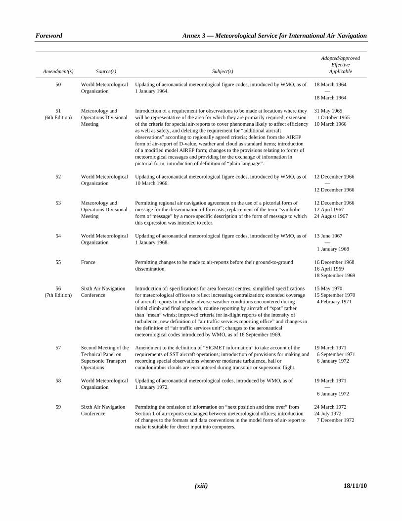
Foreword Annex 3 — Meteorological Service for International Air Navigation
(xiii) 18/11/10
Amendment(s) Source(s) Subject(s)
Adopted/approved Effective
Applicable
50 World Meteorological Organization
Updating of aeronautical meteorological figure codes, introduced by WMO, as of 1 January 1964.
18 March 1964 — 18 March 1964
51 (6th Edition)
Meteorology and Operations Divisional Meeting
Introduction of a requirement for observations to be made at locations where they will be representative of the area for which they are primarily required; extension of the criteria for special air-reports to cover phenomena likely to affect efficiency as well as safety, and deleting the requirement for “additional aircraft observations” according to regionally agreed criteria; deletion from the AIREP form of air-report of D-value, weather and cloud as standard items; introduction of a modified model AIREP form; changes to the provisions relating to forms of meteorological messages and providing for the exchange of information in pictorial form; introduction of definition of “plain language”.
31 May 1965 11 October 1965 10 March 1966
52 World Meteorological Organization
Updating of aeronautical meteorological figure codes, introduced by WMO, as of 10 March 1966.
12 December 1966 — 12 December 1966
53 Meteorology and Operations Divisional Meeting
Permitting regional air navigation agreement on the use of a pictorial form of message for the dissemination of forecasts; replacement of the term “symbolic form of message” by a more specific description of the form of message to which this expression was intended to refer.
12 December 1966 12 April 1967 24 August 1967
54 World Meteorological Organization
Updating of aeronautical meteorological figure codes, introduced by WMO, as of 1 January 1968.
13 June 1967 — 11 January 1968
55 France Permitting changes to be made to air-reports before their ground-to-ground dissemination.
16 December 1968 16 April 1969 18 September 1969
56 (7th Edition)
Sixth Air Navigation Conference
Introduction of: specifications for area forecast centres; simplified specifications for meteorological offices to reflect increasing centralization; extended coverage of aircraft reports to include adverse weather conditions encountered during initial climb and final approach; routine reporting by aircraft of “spot” rather than “mean” winds; improved criteria for in-flight reports of the intensity of turbulence; new definition of “air traffic services reporting office” and changes in the definition of “air traffic services unit”; changes to the aeronautical meteorological codes introduced by WMO, as of 18 September 1969.
15 May 1970 15 September 1970 14 February 1971
57 Second Meeting of the Technical Panel on Supersonic Transport Operations
Amendment to the definition of “SIGMET information” to take account of the requirements of SST aircraft operations; introduction of provisions for making and recording special observations whenever moderate turbulence, hail or cumulonimbus clouds are encountered during transonic or supersonic flight.
19 March 1971 16 September 1971 16 January 1972
58 World Meteorological Organization
Updating of aeronautical meteorological codes, introduced by WMO, as of 1 January 1972.
19 March 1971 — 16 January 1972
59 Sixth Air Navigation Conference
Permitting the omission of information on “next position and time over” from Section 1 of air-reports exchanged between meteorological offices; introduction of changes to the formats and data conventions in the model form of air-report to make it suitable for direct input into computers.
24 March 1972 24 July 1972 17 December 1972

Annex 3 — Meteorological Service for International Air Navigation Foreword
18/11/10 (xiv)
Amendment(s) Source(s) Subject(s)
Adopted/approved Effective
Applicable
60 (8th Edition)
Sixth Air Navigation Conference. Eighth Air Navigation Conference. Meteor- ology Divisional Meeting (1974)
Complete revision of Annex 3, incorporating the PANS-MET, the specifications of which were regarded as being suitable for inclusion in Annex 3 as Standards and Recommended Practices; the revision took into account recently approved operational requirements and up-to-date methods of meeting them; introduction of new Standards and Recommended Practices, relating to service for operators and flight crew members, meteorological information for air traffic services and for search and rescue services, together with requirements for communications and their use; the title of Annex 3 was, accordingly, amended to read Meteorological Service for International Air Navigation.
26 November 1975 26 March 1976 12 August 1976
61 Ninth Air Navigation Conference. Meteor- ology Divisional Meeting (1974)
New provisions and revision of existing provisions to improve the coordination between meteorological offices/stations and air traffic services units and the supply of meteorological information to the latter; new specifications for observations and reports for take-off and landing; introduction of a note referring to the specifications of Annex 14 for the siting and construction of equipment and installations on operational areas to reduce the hazard to aircraft to a minimum; replacement of the expression “supersonic transport aircraft” by the expression “supersonic aircraft”; updating of Part 2, Appendix 2; revision of definition of “nephanalysis” and deletion of “(29.92 in.)” from definition of “flight level”; deletion of Attachment D — Aeronautical Meteorological Codes.
14 December 1977 14 April 1978 10 August 1978
62 Eighth Air Navigation Conference and ICAO Council
Inclusion in Appendix 1 of model charts and forms developed by WMO on the basis of the operational requirements contained in Annex 3; transfer of the data designators and geographical designators from Appendix 2 to Annex 3 to the Manual of Aeronautical Meteorological Practice (Doc 8896).
26 June 1978 26 October 1978 29 November 1979
63 MET Divisional Meeting (1974). ICAO Secretariat. Operational Flight Information Service Panel. Ninth Air Navigation Confer- ence. Doc 9328
Definition for “meteorological bulletin”; correction to shortcomings in ground-to-ground dissemination of air-reports; decrease in SIGMET messages dealing with “active thunderstorm area”; deletion of reference to “reporting lines”; reference to new Manual of Runway Visual Range Observing and Reporting Practices.
23 March 1981 23 July 1981 26 November 1981
64 ICAO Secretariat New provisions and revision of existing provisions to meet operational requirements for observing and reporting of low-level wind shear, including the introduction of wind shear warnings for the climb-out and approach phases of flight.
16 December 1982 16 April 1983 24 November 1983
65 (9th Edition)
Communications/ Meteorology Divisional Meeting (1982). Third Meeting of the ADAPT Panel
New provisions and revision of existing provisions related to the introduction of the new world area forecast system; methods of exchange of operational meteorological data; improvement of accuracy of runway visual range assessment, and reporting.
10 June 1983 10 October 1983 22 November 1984

Foreword Annex 3 — Meteorological Service for International Air Navigation
(xv) 18/11/10
Amendment(s) Source(s) Subject(s)
Adopted/approved Effective
Applicable
66 (10th Edition)
Communications/ Meteorology Divisional Meeting (1982). Second Asia/ Pacific Regional Air Navigation Meeting. Twenty-second and twenty-third meetings of the European Air Navigation Planning Group. World Meteorological Organization. Recommendations of the ANC relating to the method of reference date/time and units of measurement. ICAO Secretariat
Amendment of the provisions related to the transmission of wind shear information beyond the aerodrome, criteria for the issuance of selected special reports, inclusion of cloud information in aerodrome forecasts, flight documentation to be provided for short-haul flights, format of the SIGMET message and meteorological bulletin headings; introduction of the definition for “SIGMET information”; alignment of Annex 3 with Annex 5 in respect of units of measurement and the referencing of time.
24 March 1986 27 July 1986 20 November 1986
67 Communications/ Meteorology Divisional Meeting (1982). Twenty-second and twenty-fifth meetings of the European Air Navigation Planning Group. ICAO Secretariat. World Meteorological Organization
Amendment of the provisions related to light intensity settings used for RVR assessment; the identification of selected aerodromes and the deletion of the requirement for temperature circles on WAFS charts; the transmission time of forecasts from regional area forecast centres to users; introduction of provisions for the origination and dissemination of volcanic ash warnings; inclusion of wind speed units in examples of the aviation meteorological figure codes; alignment of Annex 3 with the PANS-RAC in respect of the elements of the air-report; editorial amendment of the example of the SIGMET message.
27 March 1987 27 July 1987 19 November 1987
68 Communications/ Meteorology Divisional Meeting (1982). ICAO Secretariat. World Meteorological Organization
Amendment of the provisions relating to identification of RVR reporting positions; the criteria for the issuance of selected special reports for changes in RVR; RVR values for touchdown zone for all runways available for landing to be included in reports disseminated beyond the aerodrome; model charts and forms for flight documentation; issuance and updating of SIGMET messages relating to volcanic ash clouds; explicit provisions regarding the need to provide the aeronautical information services units with MET information; alignment with Annex 10 in respect of definitions for aeronautical fixed telecommunication network and aeronautical mobile service; alignment with PANS-OPS, Volume II, Part III, paragraph 6.3.1 in respect of terminology; editorial amendments to paragraph 3.3.7 to delete the equivalent pressure levels; the example of the SPECI report; the reference in Attachment B, Part 3, paragraph 1.4 b); and the footnote in Attachment C concerning visibility and RVR.
21 March 1989 23 July 1989 16 November 1989
69 (11th Edition)
Communications/ Meteorology/ Operations Divisional Meeting (1990). ICAO Secretariat
Amendment of the provisions related to the transition to the final phase of the WAFS; aeronautical meteorological codes, and guidance material on the selected criteria applicable to aerodrome reports; aeronautical climatological information; SIGMET information and related guidance material for the issuance of SIGMETs; automatic weather observing stations; meteorological information for helicopter operations; and alignment with Annex 6, Parts I and II in respect of the definition for alternate aerodrome.
23 March 1992 27 July 1992 12 November 1992; 11 July 1993

Annex 3 — Meteorological Service for International Air Navigation Foreword
18/11/10 (xvi)
Amendment(s) Source(s) Subject(s)
Adopted/approved Effective
Applicable
70 (12th Edition)
Communications/ Meteorology/ Operations Divisional Meeting (1990). Limited North Atlantic (COM/MET/RAC) Regional Air Navigation Meeting (1992). Third Asia/ Pacific Regional Air Navigation Meeting (1993). Thirty-second meeting of the European Air Navigation Planning Group. ICAO Secretariat
Definitions of AIRMET information, extended range operation, GAMET area forecast, operational control and tropical cyclone; amendment to the provisions concerning horizontal resolution of and the code form in which the upper wind and temperature grid point forecasts are to be prepared by the world area forecast centres; issuance of special reports for changes in temperature at aerodromes; provisions related to the reporting and forecasting of meteorological information at aerodromes on which the new aeronautical meteorological codes are based and a consequential amendment to Models A1, A2, TA1, TA2 and SN to take account of the updated aeronautical meteorological codes; automated air reporting; provision of information on weather phenomenon hazardous to low-level flights; introduction of the minimum threshold value for the maximum surface wind speed for which SIGMETs for tropical cyclones should be issued; observation and reporting of wind shear to take account of new technology in ground-based wind shear observing equipment; interregional exchange of METARs and SPECIs to support extended range operations and long-haul flights conducted under centralized operational control; editorial amendments to replace the term “line squall” by “squall line”; editorial amendments to Models SWL and SN, to align the depiction of freezing level, and editorial corrections to Model A2; inclusion in Model SN of symbols for “volcanic eruptions”, “state of the sea” and “sea surface temperature”; updating operationally desirable accuracy of measurement or observation and the currently attainable accuracy of measurement or observation; introduction of criteria for the inclusion of severe mountain waves in SIGMET information.
17 March 1995 24 July 1995 11 January 1996
71 (13th Edition)
Limited North Atlantic (COM/MET/RAC) Regional Air Navigation Meeting (1992). Third Asia/ Pacific Regional Air Navigation Meeting (1993). Thirty-eighth meeting of the European Air Navigation Planning Group (EANPG/38). United States. ICAO Secretariat
Definitions of automatic dependent surveillance, Human Factors principles, international airways volcano watch, level, tropical cyclone advisory centre, volcanic ash advisory centre and VOLMET data link service; amendment to the provisions regarding the indication of the designated meteorological authority in States’ AIPs; introduction of the role of the Human Factors principles; inclusion of 6-hour and 36-hour validity WAFS upper wind/temperature forecasts; introduction of requirements and a new model for volcanic ash advisories in graphical format; specification of the frequency of update of volcanic ash advisories and the specific role of VAACs and TCACs; an editorial amendment to ensure consistency in the order of the words “RVR” and “RWY”; an amendment to the present weather abbreviations; introduction of the requirements regarding “VOLMET” data link service; editorial amendments regarding air reporting; inclusion of “forecast temperature” in aerodrome forecasts; introduction of requirements for the standardization of area forecasts and flight documentation for low-level flights and consequential amendments to the Appendix — Model Charts and Forms; the deletion of the use of national language in connection with SIGMET messages; introduction of requirements for the provision of meteorological information by automated pre-flight information systems; introduction of the provision of meteorological information for centralized flight planning in extended range operations; quantitative definitions of CB clouds and thunderstorms to be used in WAFS SIGWX charts and consequential amendments to guidance material.
11 March 1998 20 July 1998 15 November 1998
Foreword Annex 3 — Meteorological Service for International Air Navigation
(xvii) 18/11/10
Amendment(s) Source(s) Subject(s)
Adopted/approved Effective
Applicable
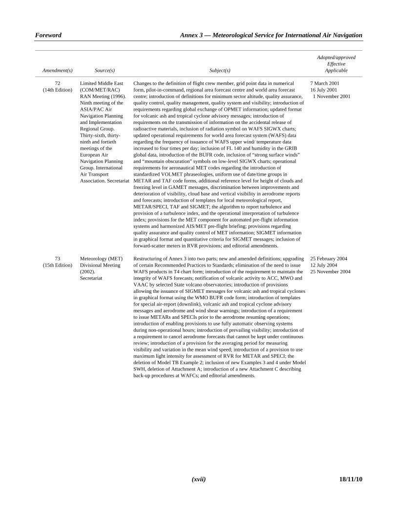
72 (14th Edition)
Limited Middle East (COM/MET/RAC) RAN Meeting (1996). Ninth meeting of the ASIA/PAC Air Navigation Planning and Implementation Regional Group. Thirty-sixth, thirty- ninth and fortieth meetings of the European Air Navigation Planning Group. International Air Transport Association. Secretariat
Changes to the definition of flight crew member, grid point data in numerical form, pilot-in-command, regional area forecast centre and world area forecast centre; introduction of definitions for minimum sector altitude, quality assurance, quality control, quality management, quality system and visibility; introduction of requirements regarding global exchange of OPMET information; updated format for volcanic ash and tropical cyclone advisory messages; introduction of requirements on the transmission of information on the accidental release of radioactive materials, inclusion of radiation symbol on WAFS SIGWX charts; updated operational requirements for world area forecast system (WAFS) data regarding the frequency of issuance of WAFS upper wind/ temperature data increased to four times per day; inclusion of FL 140 and humidity in the GRIB global data, introduction of the BUFR code, inclusion of “strong surface winds” and “mountain obscuration” symbols on low-level SIGWX charts; operational requirements for aeronautical MET codes regarding the introduction of standardized VOLMET phraseologies, uniform use of date/time groups in METAR and TAF code forms, additional reference level for height of clouds and freezing level in GAMET messages, discrimination between improvements and deterioration of visibility, cloud base and vertical visibility in aerodrome reports and forecasts; introduction of templates for local meteorological report, METAR/SPECI, TAF and SIGMET; the algorithm to report turbulence and provision of a turbulence index, and the operational interpretation of turbulence index; provisions for the MET component for automated pre-flight information systems and harmonized AIS/MET pre-flight briefing; provisions regarding quality assurance and quality control of MET information; SIGMET information in graphical format and quantitative criteria for SIGMET messages; inclusion of forward-scatter meters in RVR provisions; and editorial amendments.
7 March 2001 16 July 2001 11 November 2001
73 (15th Edition)
Meteorology (MET) Divisional Meeting (2002). Secretariat
Restructuring of Annex 3 into two parts; new and amended definitions; upgrading of certain Recommended Practices to Standards; elimination of the need to issue WAFS products in T4 chart form; introduction of the requirement to maintain the integrity of WAFS forecasts; notification of volcanic activity to ACC, MWO and VAAC by selected State volcano observatories; introduction of provisions allowing the issuance of SIGMET messages for volcanic ash and tropical cyclones in graphical format using the WMO BUFR code form; introduction of templates for special air-report (downlink), volcanic ash and tropical cyclone advisory messages and aerodrome and wind shear warnings; introduction of a requirement to issue METARs and SPECIs prior to the aerodrome resuming operations; introduction of enabling provisions to use fully automatic observing systems during non-operational hours; introduction of prevailing visibility; introduction of a requirement to cancel aerodrome forecasts that cannot be kept under continuous review; introduction of a provision for the averaging period for measuring visibility and variation in the mean wind speed; introduction of a provision to use maximum light intensity for assessment of RVR for METAR and SPECI; the deletion of Model TB Example 2; inclusion of new Examples 3 and 4 under Model SWH, deletion of Attachment A; introduction of a new Attachment C describing back-up procedures at WAFCs; and editorial amendments.
25 February 2004 12 July 2004 25 November 2004

Annex 3 — Meteorological Service for International Air Navigation Foreword
18/11/10 (xviii)
Amendment(s) Source(s) Subject(s)
Adopted/approved Effective
Applicable
74 (16th Edition)
World Area Forecast System Operations Group (WAFSOPSG). International Airways Volcano Watch Operations Group (IAVWOPSG). International Air Transport Association (IATA). ICAO Secretariat
Amendments to the definitions of “cloud of operational significance” and “prevailing visibility” and the deletion of the definition for “service area (world area forecast system)”; deletion of all requirements by SST; introduction of a requirement for volcanic ash advisory centre (VAAC) back-up procedures; elimination of the need to amend significant weather (SIGWX) forecasts; introduction of forecasts of altitude of the standard WAFS flight levels; elimination of the requirement to issue aerodrome special meteorological reports (SPECI) when half-hourly aerodrome routine meteorological reports (METAR) are issued; amendment to the reporting of gusts in local routine and special reports when noise abatement procedures are being applied; alignment of the criteria for the use of change groups in a TAF with those for the issuance of SPECI; introduction of enabling clauses to use the binary universal form for the representation of meteorological data (BUFR) code form for the dissemination of METAR/SPECI and TAF on a bilateral basis; introduction of secondary surveillance radar (SSR) Mode S data link in automatic meteorological reporting; elimination of outlook from SIGMET related to volcanic ash and tropical cyclones; introduction of the requirement to provide standard WAFS charts for fixed areas of coverage; introduction of the provision preventing modifications to the meteorological content of WAFS forecasts; upgrading of provisions in order to foster the use of WAFS forecasts; elimination of surface fronts, convergence zones and clouds other than CB from the high- and medium-level SIGWX forecasts; advancement of the lead time of issuance of SIGWX forecasts; harmonization of the volcanic ash advisory format with the tropical cyclone advisory format; introduction of a criterion related to the issuance of tropical cyclone advisories; amendments to the tropical cyclone advisory to introduce 6-hour forecasts; change to the definition of “vicinity”; expansion of the use of automatic systems to include operational hours; amendments to the automatic reporting of turbulence; introduction of a new template for GAMET messages; extension of the validity period of TAF to meet requirements for very long-haul flights; introduction of provisions for graphical SIGMET for all phenomena; update of the SIGMET template to include radioactive cloud; introduction of “tsunami” in aerodrome warnings; alignment of Annexes 3 and 11 provisions concerning meteorological information to be supplied to air traffic services (ATS); amendment of the criteria to include SIGMET and TAF in VOLMET and D-VOLMET; deletion of the attainable accuracy of observation and measurement from Attachment A; update of the desirable accuracy in Attachment B; and editorial amendments.
21 February 2007 16 July 2007 17 November 2007; 15 November 2008

Foreword Annex 3 — Meteorological Service for International Air Navigation
(xix) 18/11/10
Amendment(s) Source(s) Subject(s)
Adopted/approved Effective
Applicable
75 (17th Edition)
Meteorological Warnings Study Group (METWSG). World Area Forecast System Operations Group (WAFSOPSG). Meteorological Information Data Link Study Group (METLINKSG). International Airways Volcano Watch Operations Group (IAVWOPSG). Aerodrome Meteorological Observation and Forecast Study Group (AMOFSG). Aviation Use of the Public Internet Study Group (AUPISG). Required Navigation Performance Special Operational Requirements Study Group (RNPSORSG)
The amendment introduces provisions related to SIGMET information, wind shear warnings, quality management systems; improved horizontal, vertical and temporal resolutions for WAFS forecasts and the introduction of an enabling clause for the implementation of improved WAFS forecasts of cumulonimbus clouds, icing and turbulence; elimination of routine voice reports related to weather and the enabling of the provision of graphical MET information in the cockpit; enhancement of the provision of information on volcanic ash and toxic chemicals; aerodrome observations and forecasts enabling the use of fully automatic observing systems for the provision of local reports and the replacement of km/h by m/s for the SI unit to report wind speed. It also introduces consequential amendments related to the provision of performance-based navigation terminology and the operational use of the public Internet.
22 February 2010 12 July 2010 18 November 2010; 15 November 2012
___________________


INTERNATIONAL STANDARDS AND RECOMMENDED PRACTICES
PART I
CORE SARPs

ANNEX 3 1-1 18/11/10
CHAPTER 1. DEFINITIONS
Note.— The designation (RR) in these definitions indicates a definition which has been extracted from the Radio Regulations of the International Telecommunication Union (ITU) (see Handbook on Radio Frequency Spectrum Requirements for Civil Aviation including Statement of Approved ICAO Policies (Doc 9718)).
1.1 Definitions When the following terms are used in the Standards and Recommended Practices for Meteorological Service for International Air Navigation, they have the following meanings: Aerodrome. A defined area on land or water (including any buildings, installations and equipment) intended to be used either
wholly or in part for the arrival, departure and surface movement of aircraft. Aerodrome climatological summary. Concise summary of specified meteorological elements at an aerodrome, based on
statistical data. Aerodrome climatological table. Table providing statistical data on the observed occurrence of one or more meteorological
elements at an aerodrome. Aerodrome control tower. A unit established to provide air traffic control service to aerodrome traffic. Aerodrome elevation. The elevation of the highest point of the landing area. Aerodrome meteorological office. An office, located at an aerodrome, designated to provide meteorological service for
international air navigation. Aerodrome reference point. The designated geographical location of an aerodrome. Aeronautical fixed service (AFS). A telecommunication service between specified fixed points provided primarily for the
safety of air navigation and for the regular, efficient and economical operation of air services. Aeronautical fixed telecommunication network (AFTN). A worldwide system of aeronautical fixed circuits provided, as
part of the aeronautical fixed service, for the exchange of messages and/or digital data between aeronautical fixed stations having the same or compatible communications characteristics.
Aeronautical meteorological station. A station designated to make observations and meteorological reports for use in
international air navigation. Aeronautical mobile service (RR S1.32). A mobile service between aeronautical stations and aircraft stations, or between
aircraft stations, in which survival craft stations may participate; emergency position-indicating radio beacon stations may also participate in this service on designated distress and emergency frequencies.
Aeronautical telecommunication station. A station in the aeronautical telecommunication service. Aircraft. Any machine that can derive support in the atmosphere from the reactions of the air other than the reactions of the
air against the earth’s surface.
Annex 3 — Meteorological Service for International Air Navigation Chapter 1
18/11/10 1-2
Aircraft observation. The evaluation of one or more meteorological elements made from an aircraft in flight. AIRMET information. Information issued by a meteorological watch office concerning the occurrence or expected
occurrence of specified en-route weather phenomena which may affect the safety of low-level aircraft operations and which was not already included in the forecast issued for low-level flights in the flight information region concerned or sub-area thereof.
Air-report. A report from an aircraft in flight prepared in conformity with requirements for position, and operational and/or
meteorological reporting. Note.— Details of the AIREP form are given in the PANS-ATM (Doc 4444). Air traffic services unit. A generic term meaning variously, air traffic control unit, flight information centre or air traffic
services reporting office. Alternate aerodrome. An aerodrome to which an aircraft may proceed when it becomes either impossible or inadvisable to
proceed to or to land at the aerodrome of intended landing. Alternate aerodromes include the following:
Take-off alternate. An alternate aerodrome at which an aircraft can land should this become necessary shortly after take-off and it is not possible to use the aerodrome of departure.
En-route alternate. An aerodrome at which an aircraft would be able to land after experiencing an abnormal or
emergency condition while en route.
ETOPS en-route alternate. A suitable and appropriate alternate aerodrome at which an aeroplane would be able to land after experiencing an engine shut-down or other abnormal or emergency condition while en route in an ETOPS operation.
Destination alternate. An alternate aerodrome to which an aircraft may proceed should it become either impossible or
inadvisable to land at the aerodrome of intended landing. Note.— The aerodrome from which a flight departs may also be an en-route or a destination alternate aerodrome for that flight. Altitude. The vertical distance of a level, a point or an object considered as a point, measured from mean sea level (MSL). Approach control unit. A unit established to provide air traffic control service to controlled flights arriving at, or departing
from, one or more aerodromes. Appropriate ATS authority. The relevant authority designated by the State responsible for providing air traffic services in the
airspace concerned. Area control centre. A unit established to provide air traffic control service to controlled flights in control areas under its
jurisdiction. Area navigation (RNAV). A method of navigation which permits aircraft operations on any desired flight path within the
coverage of ground- or space-based navigation aids or within the limits of the capability of self-contained aids, or a combination of these.
Note.— Area navigation includes performance-based navigation as well as other operations that do not meet the definition of performance-based navigation.
Chapter 1 Annex 3 — Meteorological Service for International Air Navigation
1-3 18/11/10
Automatic dependent surveillance (ADS). A surveillance technique in which aircraft automatically provide, via a data link, data derived from on-board navigation and position-fixing systems, including aircraft identification, four-dimensional position and additional data as appropriate.
Briefing. Oral commentary on existing and/or expected meteorological conditions. Cloud of operational significance. A cloud with the height of cloud base below 1 500 m (5 000 ft) or below the highest
minimum sector altitude, whichever is greater, or a cumulonimbus cloud or a towering cumulus cloud at any height. Consultation. Discussion with a meteorologist or another qualified person of existing and/or expected meteorological
conditions relating to flight operations; a discussion includes answers to questions. Control area. A controlled airspace extending upwards from a specified limit above the earth. Cruising level. A level maintained during a significant portion of a flight. Elevation. The vertical distance of a point or a level, on or affixed to the surface of the earth, measured from mean sea level. Extended range operation. Any flight by an aeroplane with two turbine engines where the flight time at the one engine
inoperative cruise speed (in ISA and still air conditions), from a point on the route to an adequate alternate aerodrome, is greater than the threshold time approved by the State of the Operator.
Flight crew member. A licensed crew member charged with duties essential to the operation of an aircraft during a flight
duty period. Flight documentation. Written or printed documents, including charts or forms, containing meteorological information for a
flight. Flight information centre. A unit established to provide flight information service and alerting service. Flight information region. An airspace of defined dimensions within which flight information service and alerting service
are provided. Flight level. A surface of constant atmospheric pressure which is related to a specific pressure datum, 1 013.2 hectopascals
(hPa), and is separated from other such surfaces by specific pressure intervals. Note 1.— A pressure type altimeter calibrated in accordance with the Standard Atmosphere: a) when set to a QNH altimeter setting, will indicate altitude; b) when set to a QFE altimeter setting, will indicate height above the QFE reference datum; c) when set to a pressure of 1 013.2 hPa, may be used to indicate flight levels. Note 2.— The terms “height” and “altitude”, used in Note 1, indicate altimetric rather than geometric heights and altitudes. Forecast. A statement of expected meteorological conditions for a specified time or period, and for a specified area or portion
of airspace. GAMET area forecast. An area forecast in abbreviated plain language for low-level flights for a flight information region or
sub-area thereof, prepared by the meteorological office designated by the meteorological authority concerned and exchanged with meteorological offices in adjacent flight information regions, as agreed between the meteorological authorities concerned.

Annex 3 — Meteorological Service for International Air Navigation Chapter 1
18/11/10 1-4
Grid point data in digital form. Computer processed meteorological data for a set of regularly spaced points on a chart, for transmission from a meteorological computer to another computer in a code form suitable for automated use.
Note.— In most cases, such data are transmitted on medium- or high-speed telecommunications channels. Height. The vertical distance of a level, a point or an object considered as a point, measured from a specified datum. Human Factors principles. Principles which apply to aeronautical design, certification, training, operations and maintenance
and which seek safe interface between the human and other system components by proper consideration to human performance.
International airways volcano watch (IAVW). International arrangements for monitoring and providing warnings to aircraft
of volcanic ash in the atmosphere. Note.— The IAVW is based on the cooperation of aviation and non-aviation operational units using information derived from observing sources and networks that are provided by States. The watch is coordinated by ICAO with the cooperation of other concerned international organizations. Level. A generic term relating to the vertical position of an aircraft in flight and meaning variously height, altitude or flight
level. Meteorological authority. The authority providing or arranging for the provision of meteorological service for international
air navigation on behalf of a Contracting State. Meteorological bulletin. A text comprising meteorological information preceded by an appropriate heading. Meteorological information. Meteorological report, analysis, forecast, and any other statement relating to existing or
expected meteorological conditions. Meteorological office. An office designated to provide meteorological service for international air navigation. Meteorological report. A statement of observed meteorological conditions related to a specified time and location. Meteorological satellite. An artificial Earth satellite making meteorological observations and transmitting these observations
to Earth. Minimum sector altitude. The lowest altitude which may be used which will provide a minimum clearance of 300 m
(1 000 ft) above all objects located in an area contained within a sector of a circle of 46 km (25 NM) radius centred on a radio aid to navigation.
Navigation specification. A set of aircraft and flight crew requirements needed to support performance-based navigation
operations within a defined airspace. There are two kinds of navigation specifications: Required navigation performance (RNP) specification. A navigation specification based on area navigation that includes
the requirement for performance monitoring and alerting, designated by the prefix RNP, e.g. RNP 4, RNP APCH. Area navigation (RNAV) specification. A navigation specification based on area navigation that does not include the
requirement for performance monitoring and alerting, designated by the prefix RNAV, e.g. RNAV 5, RNAV 1. Note.— The Performance-based Navigation (PBN) Manual (Doc 9613), Volume II, contains detailed guidance on navigation specifications. Observation (meteorological). The evaluation of one or more meteorological elements.

Chapter 1 Annex 3 — Meteorological Service for International Air Navigation
1-5 18/11/10
Operational control. The exercise of authority over the initiation, continuation, diversion or termination of a flight in the interest of the safety of the aircraft and the regularity and efficiency of the flight.
Operational flight plan. The operator’s plan for the safe conduct of the flight based on considerations of aeroplane
performance, other operating limitations and relevant expected conditions on the route to be followed and at the aerodromes concerned.
Operational planning. The planning of flight operations by an operator. Operator. A person, organization or enterprise engaged in or offering to engage in an aircraft operation. Performance-based navigation (PBN). Area navigation based on performance requirements for aircraft operating along an
ATS route, on an instrument approach procedure or in a designated airspace. Note.— Performance requirements are expressed in navigation specification (RNAV specification, RNP specification) in terms of accuracy, integrity, continuity, availability and functionality needed for the proposed operation in the context of a particular airspace concept. Pilot-in-command. The pilot designated by the operator, or in the case of general aviation, the owner, as being in command
and charged with the safe conduct of a flight. Prevailing visibility. The greatest visibility value, observed in accordance with the definition of “visibility”, which is reached
within at least half the horizon circle or within at least half of the surface of the aerodrome. These areas could comprise contiguous or non-contiguous sectors.
Note.— This value may be assessed by human observation and/or instrumented systems. When instruments are installed, they are used to obtain the best estimate of the prevailing visibility. Prognostic chart. A forecast of a specified meteorological element(s) for a specified time or period and a specified surface or
portion of airspace, depicted graphically on a chart. Quality assurance. Part of quality management focused on providing confidence that quality requirements will be fulfilled
(ISO 9000*). Quality control. Part of quality management focused on fulfilling quality requirements (ISO 9000*). Quality management. Coordinated activities to direct and control an organization with regard to quality (ISO 9000*). Regional air navigation agreement. Agreement approved by the Council of ICAO normally on the advice of a regional air
navigation meeting. Reporting point. A specified geographical location in relation to which the position of an aircraft can be reported. Rescue coordination centre. A unit responsible for promoting efficient organization of search and rescue services and for
coordinating the conduct of search and rescue operations within a search and rescue region. Runway. A defined rectangular area on a land aerodrome prepared for the landing and take-off of aircraft. Runway visual range (RVR). The range over which the pilot of an aircraft on the centre line of a runway can see the runway
surface markings or the lights delineating the runway or identifying its centre line.
* ISO Standard 9000 — Quality Management Systems — Fundamentals and Vocabulary.

Annex 3 — Meteorological Service for International Air Navigation Chapter 1
18/11/10 1-6
Search and rescue services unit. A generic term meaning, as the case may be, rescue coordination centre, rescue subcentre or alerting post.
SIGMET information. Information issued by a meteorological watch office concerning the occurrence or expected
occurrence of specified en-route weather phenomena which may affect the safety of aircraft operations. Standard isobaric surface. An isobaric surface used on a worldwide basis for representing and analysing the conditions in
the atmosphere. Threshold. The beginning of that portion of the runway usable for landing. Touchdown zone. The portion of a runway, beyond the threshold, where it is intended landing aeroplanes first contact the
runway. Tropical cyclone. Generic term for a non-frontal synoptic-scale cyclone originating over tropical or sub-tropical waters with
organized convection and definite cyclonic surface wind circulation. Tropical cyclone advisory centre (TCAC). A meteorological centre designated by regional air navigation agreement to
provide advisory information to meteorological watch offices, world area forecast centres and international OPMET databanks regarding the position, forecast direction and speed of movement, central pressure and maximum surface wind of tropical cyclones.
Upper-air chart. A meteorological chart relating to a specified upper-air surface or layer of the atmosphere. Visibility. Visibility for aeronautical purposes is the greater of: a) the greatest distance at which a black object of suitable dimensions, situated near the ground, can be seen and
recognized when observed against a bright background; b) the greatest distance at which lights in the vicinity of 1 000 candelas can be seen and identified against an unlit
background. Note.— The two distances have different values in air of a given extinction coefficient, and the latter b) varies with the background illumination. The former a) is represented by the meteorological optical range (MOR). Volcanic ash advisory centre (VAAC). A meteorological centre designated by regional air navigation agreement to provide
advisory information to meteorological watch offices, area control centres, flight information centres, world area forecast centres and international OPMET databanks regarding the lateral and vertical extent and forecast movement of volcanic ash in the atmosphere following volcanic eruptions.
VOLMET. Meteorological information for aircraft in flight. Data link-VOLMET (D-VOLMET). Provision of current aerodrome routine meteorological reports (METAR) and
aerodrome special meteorological reports (SPECI), aerodrome forecasts (TAF), SIGMET, special air-reports not covered by a SIGMET and, where available, AIRMET via data link.
VOLMET broadcast. Provision, as appropriate, of current METAR, SPECI, TAF and SIGMET by means of continuous
and repetitive voice broadcasts. World area forecast centre (WAFC). A meteorological centre designated to prepare and issue significant weather forecasts
and upper-air forecasts in digital form on a global basis direct to States by appropriate means as part of the aeronautical fixed service.
World area forecast system (WAFS). A worldwide system by which world area forecast centres provide aeronautical
meteorological en-route forecasts in uniform standardized formats.

Chapter 1 Annex 3 — Meteorological Service for International Air Navigation
1-7 18/11/10
1.2 Terms used with a limited meaning For the purpose of this Annex, the following terms are used with a limited meaning as indicated below: a) to avoid confusion in respect of the term “service” between the meteorological service considered as an
administrative entity and the service which is provided, “meteorological authority” is used for the former and “service” for the latter;
b) “provide” is used solely in connection with the provision of service; c) “issue” is used solely in connection with cases where the obligation specifically extends to sending out the
information to a user; d) “make available” is used solely in connection with cases where the obligation ends with making the information
accessible to a user; and
e) “supply” is used solely in connection with cases where either c) or d) applies.
___________________


ANNEX 3 2-1 18/11/10
CHAPTER 2. GENERAL PROVISIONS
Introductory Note 1.— It is recognized that the provisions of this Annex with respect to meteorological information are subject to the understanding that the obligation of a Contracting State is for the supply, under Article 28 of the Convention, of meteorological information and that the responsibility for the use made of such information is that of the user. Introductory Note 2.— Although the Convention on International Civil Aviation allocates to the State of Registry certain functions which that State is entitled to discharge, or obligated to discharge, as the case may be, the Assembly recognized, in Resolution A23-13, that the State of Registry may be unable to fulfil its responsibilities adequately in instances where aircraft are leased, chartered or interchanged — in particular without crew — by an operator of another State and that the Convention may not adequately specify the rights and obligations of the State of an operator in such instances until such time as Article 83 bis of the Convention enters into force. Accordingly, the Council urged that if, in the above-mentioned instances, the State of Registry finds itself unable to discharge adequately the functions allocated to it by the Convention, it delegate to the State of the Operator, subject to acceptance by the latter State, those functions of the State of Registry that can more adequately be discharged by the State of the Operator. It was understood that pending entry into force of Article 83 bis of the Convention the foregoing action would only be a matter of practical convenience and would not affect either the provisions of the Chicago Convention prescribing the duties of the State of Registry or any third State. However, as Article 83 bis of the Convention entered into force on 20 June 1997, such transfer agreements will have effect in respect of Contracting States which have ratified the related Protocol (Doc 9318) upon fulfilment of the conditions established in Article 83 bis. Introductory Note 3.— In the case of international operations effected jointly with aeroplanes not all of which are registered in the same Contracting State, nothing in this Annex prevents the States concerned entering into an agreement for the joint exercise of the functions placed upon the State of Registry by the provisions of this Annex.
2.1 Objective, determination and provision of meteorological service
2.1.1 The objective of meteorological service for international air navigation shall be to contribute towards the safety, regularity and efficiency of international air navigation. 2.1.2 This objective shall be achieved by supplying the following users: operators, flight crew members, air traffic services units, search and rescue services units, airport managements and others concerned with the conduct or development of international air navigation, with the meteorological information necessary for the performance of their respective functions. 2.1.3 Each Contracting State shall determine the meteorological service which it will provide to meet the needs of international air navigation. This determination shall be made in accordance with the provisions of this Annex and with due regard to regional air navigation agreements; it shall include the determination of the meteorological service to be provided for international air navigation over international waters and other areas which lie outside the territory of the State concerned. 2.1.4 Each Contracting State shall designate the authority, hereinafter referred to as the meteorological authority, to provide or to arrange for the provision of meteorological service for international air navigation on its behalf. Details of the meteorological authority so designated shall be included in the State aeronautical information publication, in accordance with Annex 15, Appendix 1, GEN 1.1.

Annex 3 — Meteorological Service for International Air Navigation Chapter 2
18/11/10 2-2
2.1.5 Each Contracting State shall ensure that the designated meteorological authority complies with the requirements of the World Meteorological Organization in respect of qualifications and training of meteorological personnel providing service for international air navigation. Note.— Requirements concerning qualifications and training of meteorological personnel in aeronautical meteorology are given in WMO Publication No. 49, Technical Regulations, Volume I — General Meteorological Standards and Recommended Practices, Chapter B.4 — Education and Training.
2.2 Supply, use and quality management of meteorological information 2.2.1 Close liaison shall be maintained between those concerned with the supply and those concerned with the use of meteorological information on matters which affect the provision of meteorological service for international air navigation. 2.2.2 Recommendation.— Until 14 November 2012, in order to meet the objective of meteorological service for international air navigation, the Contracting State should ensure that the designated meteorological authority referred to in 2.1.4 establishes and implements a properly organized quality system comprising procedures, processes and resources necessary to provide for the quality management of the meteorological information to be supplied to the users listed in 2.1.2. 2.2.3 From 15 November 2012, each Contracting State shall ensure that the designated meteorological authority referred to in 2.1.4 establishes and implements a properly organized quality system comprising procedures, processes and resources necessary to provide for the quality management of the meteorological information to be supplied to the users listed in 2.1.2. 2.2.4 Recommendation.— The quality system established in accordance with 2.2.2 should be in conformity with the International Organization for Standardization (ISO) 9000 series of quality assurance standards and should be certified by an approved organization. Note.— The International Organization for Standardization (ISO) 9000 series of quality assurance standards provide a basic framework for the development of a quality assurance programme. The details of a successful programme are to be formulated by each State and in most cases are unique to the State organization. Guidance on the establishment and implementation of a quality system is given in the Manual on the Quality Management System for the Provision of Meteorological Service to International Air Navigation (Doc 9873). 2.2.5 Recommendation.— The quality system should provide the users with assurance that the meteorological information supplied complies with the stated requirements in terms of the geographical and spatial coverage, format and content, time and frequency of issuance and period of validity, as well as the accuracy of measurements, observations and forecasts. When the quality system indicates that meteorological information to be supplied to the users does not comply with the stated requirements, and automatic error correction procedures are not appropriate, such information should not be supplied to the users unless it is validated with the originator. Note.— Requirements concerning the geographical and spatial coverage, format and content, time and frequency of issuance and period of validity of meteorological information to be supplied to aeronautical users are given in Chapters 3, 4, 6, 7, 8, 9 and 10 and Appendices 2, 3, 5, 6, 7, 8 and 9 of this Annex and the relevant regional air navigation plans. Guidance concerning the accuracy of measurement and observation, and accuracy of forecasts is given in Attachments A and B, respectively, to this Annex. 2.2.6 Recommendation.— In regard to the exchange of meteorological information for operational purposes, the quality system should include verification and validation procedures and resources for monitoring adherence to the prescribed transmission schedules for individual messages and/or bulletins required to be exchanged, and the times of their filing for transmission. The quality system should be capable of detecting excessive transit times of messages and bulletins received.

Chapter 2 Annex 3 — Meteorological Service for International Air Navigation
2-3 18/11/10
Note.— Requirements concerning the exchange of operational meteorological information are given in Chapter 11 and Appendix 10 of this Annex. 2.2.7 Recommendation.— Demonstration of compliance of the quality system applied should be by audit. If non- conformity of the system is identified, action should be initiated to determine and correct the cause. All audit observations should be evidenced and properly documented. 2.2.8 The meteorological information supplied to the users listed in 2.1.2 shall be consistent with Human Factors principles and shall be in forms which require a minimum of interpretation by these users, as specified in the following chapters. Note.— Guidance material on the application of Human Factors principles can be found in the Human Factors Training Manual (Doc 9683).
2.3 Notifications required from operators 2.3.1 An operator requiring meteorological service or changes in existing meteorological service shall notify, sufficiently in advance, the meteorological authority or the meteorological office(s) concerned. The minimum amount of advance notice required shall be as agreed between the meteorological authority or meteorological office(s) and the operator. 2.3.2 The meteorological authority shall be notified by the operator requiring service when: a) new routes or new types of operations are planned; b) changes of a lasting character are to be made in scheduled operations; and c) other changes, affecting the provision of meteorological service, are planned. Such information shall contain all details necessary for the planning of appropriate arrangements by the meteorological authority. 2.3.3 The aerodrome meteorological office, or the meteorological office concerned, shall be notified by the operator or a flight crew member: a) of flight schedules; b) when non-scheduled flights are to be operated; and c) when flights are delayed, advanced or cancelled. 2.3.4 Recommendation.— The notification to the aerodrome meteorological office, or the meteorological office concerned, of individual flights should contain the following information except that, in the case of scheduled flights, the requirement for some or all of this information may be waived by agreement between the meteorological office and the operator: a) aerodrome of departure and estimated time of departure; b) destination and estimated time of arrival; c) route to be flown and estimated times of arrival at, and departure from, any intermediate aerodrome(s);

Annex 3 — Meteorological Service for International Air Navigation Chapter 2
18/11/10 2-4
d) alternate aerodromes needed to complete the operational flight plan and taken from the relevant list contained in the regional air navigation plan;
e) cruising level; f) type of flight, whether under visual or instrument flight rules; g) type of meteorological information requested for a flight crew member, whether flight documentation and/or
briefing or consultation; and h) time(s) at which briefing, consultation and/or flight documentation are required.
___________________
ANNEX 3 3-1 18/11/10
CHAPTER 3. WORLD AREA FORECAST SYSTEM AND METEOROLOGICAL OFFICES
Note.— Technical specifications and detailed criteria related to this chapter are given in Appendix 2.
3.1 Objective of the world area forecast system The objective of the world area forecast system shall be to supply meteorological authorities and other users with global aeronautical meteorological en-route forecasts in digital form. This objective shall be achieved through a comprehensive, integrated, worldwide and, as far as practicable, uniform system, and in a cost-effective manner, taking full advantage of evolving technologies.
3.2 World area forecast centres 3.2.1 A Contracting State, having accepted the responsibility for providing a WAFC within the framework of the world area forecast system, shall arrange for that centre: a) to prepare gridded global forecasts of: 1) upper wind; 2) upper-air temperature and humidity; 3) geopotential altitude of flight levels; 4) flight level and temperature of tropopause; 5) direction, speed and flight level of maximum wind; 6) cumulonimbus clouds; 7) icing; and 8) turbulence; Note.— Gridded global forecasts of cumulonimbus clouds, icing and turbulence are currently of an experimental nature, labelled as “trial forecasts” and distributed only through the Internet-based file transfer protocol (FTP) services. b) to prepare global forecasts of significant weather (SIGWX) phenomena; c) to issue the forecasts referred to in a) and b) in digital form to meteorological authorities and other users, as
approved by the Contracting State on advice from the meteorological authority;

Annex 3 — Meteorological Service for International Air Navigation Chapter 3
18/11/10 3-2
d) to receive information concerning the accidental release of radioactive materials into the atmosphere from its associated WMO regional specialized meteorological centre (RSMC) for the provision of transport model products for radiological environmental emergency response, in order to include the information in SIGWX forecasts; and
e) to establish and maintain contact with VAACs for the exchange of information on volcanic activity in order to
coordinate the inclusion of information on volcanic eruptions in SIGWX forecasts. 3.2.2 In case of interruption of the operation of a WAFC, its functions shall be carried out by the other WAFC. Note.— Back-up procedures to be used in case of interruption of the operation of a WAFC are updated by the World Area Forecast System Operations Group (WAFSOPSG) as necessary; the latest revision can be found at the WAFSOPSG website at www.icao.int/anb/wafsopsg.
3.3 Meteorological offices 3.3.1 Each Contracting State shall establish one or more aerodrome and/or other meteorological offices which shall be adequate for the provision of the meteorological service required to satisfy the needs of international air navigation. 3.3.2 An aerodrome meteorological office shall carry out all or some of the following functions as necessary to meet the needs of flight operations at the aerodrome: a) prepare and/or obtain forecasts and other relevant information for flights with which it is concerned; the extent of its
responsibilities to prepare forecasts shall be related to the local availability and use of en-route and aerodrome forecast material received from other offices;
b) prepare and/or obtain forecasts of local meteorological conditions; c) maintain a continuous survey of meteorological conditions over the aerodromes for which it is designated to prepare
forecasts; d) provide briefing, consultation and flight documentation to flight crew members and/or other flight operations
personnel; e) supply other meteorological information to aeronautical users; f) display the available meteorological information; g) exchange meteorological information with other meteorological offices; and h) supply information received on pre-eruption volcanic activity, a volcanic eruption or volcanic ash cloud, to its
associated air traffic services unit, aeronautical information service unit and meteorological watch office as agreed between the meteorological, aeronautical information service and ATS authorities concerned.
3.3.3 The aerodromes for which landing forecasts are required shall be determined by regional air navigation agreement. 3.3.4 For aerodromes without meteorological offices: a) the meteorological authority concerned shall designate one or more meteorological offices to supply meteorological
information as required; and

Chapter 3 Annex 3 — Meteorological Service for International Air Navigation
3-3 18/11/10
b) the competent authorities shall establish means by which such information can be supplied to the aerodromes concerned.
3.4 Meteorological watch offices 3.4.1 A Contracting State, having accepted the responsibility for providing air traffic services within a flight information region or a control area, shall establish, on the basis of regional air navigation agreement, one or more meteorological watch offices, or arrange for another Contracting State to do so. 3.4.2 A meteorological watch office shall: a) maintain continuous watch over meteorological conditions affecting flight operations within its area of
responsibility; b) prepare SIGMET and other information relating to its area of responsibility; c) supply SIGMET information and, as required, other meteorological information to associated air traffic services
units; d) disseminate SIGMET information; e) when required by regional air navigation agreement, in accordance with 7.2.1: 1) prepare AIRMET information related to its area of responsibility; 2) supply AIRMET information to associated air traffic services units; and 3) disseminate AIRMET information; f) supply information received on pre-eruption volcanic activity, a volcanic eruption and volcanic ash cloud for which
a SIGMET has not already been issued, to its associated ACC/FIC, as agreed between the meteorological and ATS authorities concerned, and to its associated VAAC as determined by regional air navigation agreement; and
g) supply information received concerning the accidental release of radioactive materials into the atmosphere, in the
area for which it maintains watch or adjacent areas, to its associated ACC/FIC, as agreed between the meteorological and ATS authorities concerned, and to aeronautical information service units, as agreed between the meteorological and appropriate civil aviation authorities concerned. The information shall comprise location, date and time of the accident, and forecast trajectories of the radioactive materials.
Note.— The information is provided by WMO regional specialized meteorological centres (RSMC) for the provision of transport model products for radiological environmental emergency response, at the request of the delegated authority of the State in which the radioactive material was released into the atmosphere, or the International Atomic Energy Agency (IAEA). The information is sent by the RSMC to a single contact point of the national meteorological service in each State. This contact point has the responsibility of redistributing the RSMC products within the State concerned. Furthermore, the information is provided by IAEA to RSMC co-located with VAAC London (designated as the focal point) which in turn notifies the ACCs concerned about the release. 3.4.3 Recommendation.— The boundaries of the area over which meteorological watch is to be maintained by a meteorological watch office should be coincident with the boundaries of a flight information region or a control area or a combination of flight information regions and/or control areas.

Annex 3 — Meteorological Service for International Air Navigation Chapter 3
18/11/10 3-4
3.5 Volcanic ash advisory centres 3.5.1 A Contracting State, having accepted, by regional air navigation agreement, the responsibility for providing a VAAC within the framework of the international airways volcano watch, shall arrange for that centre to respond to a notification that a volcano has erupted, or is expected to erupt or volcanic ash is reported in its area of responsibility, by arranging for that centre to: a) monitor relevant geostationary and polar-orbiting satellite data to detect the existence and extent of volcanic ash in
the atmosphere in the area concerned; b) activate the volcanic ash numerical trajectory/dispersion model in order to forecast the movement of any ash “cloud”
which has been detected or reported; Note.— The numerical model may be its own or, by agreement, that of another VAAC. c) issue advisory information regarding the extent and forecast movement of the volcanic ash “cloud” to: 1) meteorological watch offices, area control centres and flight information centres serving flight information
regions in its area of responsibility which may be affected; 2) other VAACs whose areas of responsibility may be affected; 3) world area forecast centres, international OPMET databanks, international NOTAM offices, and centres
designated by regional air navigation agreement for the operation of aeronautical fixed service satellite distribution systems; and
4) airlines requiring the advisory information through the AFTN address provided specifically for this purpose;
and Note.— The AFTN address to be used by the VAACs is given in the Handbook on the International Airways
Volcano Watch (IAVW) (Doc 9766) and at http://www.icao.int/icao/en/anb/met/index.html. d) issue updated advisory information to the meteorological watch offices, area control centres, flight information
centres and VAACs referred to in c), as necessary, but at least every six hours until such time as the volcanic ash “cloud” is no longer identifiable from satellite data, no further reports of volcanic ash are received from the area, and no further eruptions of the volcano are reported.
3.5.2 Volcanic ash advisory centres shall maintain a 24-hour watch. 3.5.3 In case of interruption of the operation of a VAAC, its functions shall be carried out by another VAAC or another meteorological centre, as designated by the VAAC Provider State concerned. Note.― Back-up procedures to be used in case of interruption of the operation of a VAAC are included in the Handbook on the International Airways Volcano Watch (IAVW) (Doc 9766).
3.6 State volcano observatories Contracting States that maintain volcano observatories monitoring active volcanoes shall arrange that selected State volcano observatories, as designated by regional air navigation agreement, observing: a) significant pre-eruption volcanic activity, or a cessation thereof;

Chapter 3 Annex 3 — Meteorological Service for International Air Navigation
3-5 18/11/10
b) a volcanic eruption, or a cessation thereof; and/or c) volcanic ash in the atmosphere shall send this information as quickly as practicable to their associated ACC, MWO and VAAC. Note.— Pre-eruption volcanic activity in this context means unusual and/or increasing volcanic activity which could presage a volcanic eruption.
3.7 Tropical cyclone advisory centres A Contracting State having accepted, by regional air navigation agreement, the responsibility for providing a TCAC shall arrange for that centre to: a) monitor the development of tropical cyclones in its area of responsibility, using geostationary and polar-orbiting
satellite data, radar data and other meteorological information; b) issue advisory information concerning the position of the cyclone centre, its direction and speed of movement,
central pressure and maximum surface wind near the centre, in abbreviated plain language to: 1) meteorological watch offices in its area of responsibility; 2) other TCACs whose areas of responsibility may be affected; and 3) world area forecast centres, international OPMET databanks, and centres designated by regional air navigation
agreement for the operation of aeronautical fixed service satellite distribution systems; and c) issue updated advisory information to meteorological watch offices for each tropical cyclone, as necessary, but at
least every six hours.
___________________


ANNEX 3 4-1 18/11/10
CHAPTER 4. METEOROLOGICAL OBSERVATIONS AND REPORTS
Note.— Technical specifications and detailed criteria related to this chapter are given in Appendix 3.
4.1 Aeronautical meteorological stations and observations 4.1.1 Each Contracting State shall establish, at aerodromes in its territory, such aeronautical meteorological stations as it determines to be necessary. An aeronautical meteorological station may be a separate station or may be combined with a synoptic station. Note.— Aeronautical meteorological stations may include sensors installed outside the aerodrome, where considered justified, by the meteorological authority to ensure the compliance of meteorological service for international air navigation with the provisions of this Annex. 4.1.2 Recommendation.— Each Contracting State should establish, or arrange for the establishment of, aero- nautical meteorological stations on offshore structures or at other points of significance in support of helicopter operations to offshore structures, if required by regional air navigation agreement. 4.1.3 Aeronautical meteorological stations shall make routine observations at fixed intervals. At aerodromes, the routine observations shall be supplemented by special observations whenever specified changes occur in respect of surface wind, visibility, runway visual range, present weather, clouds and/or air temperature. 4.1.4 Each Contracting State shall arrange for its aeronautical meteorological stations to be inspected at sufficiently frequent intervals to ensure that a high standard of observation is maintained, that instruments and all their indicators are functioning correctly, and that the exposure of the instruments has not changed significantly. Note.— Guidance on the inspection of aeronautical meteorological stations including the frequency of inspections is given in the Manual on Automatic Meteorological Observing Systems at Aerodromes (Doc 9837). 4.1.5 At aerodromes with runways intended for Category II and III instrument approach and landing operations, automated equipment for measuring or assessing, as appropriate, and for monitoring and remote indicating of surface wind, visibility, runway visual range, height of cloud base, air and dew-point temperatures and atmospheric pressure shall be installed to support approach and landing and take-off operations. These devices shall be integrated automatic systems for acquisition, processing, dissemination and display in real time of the meteorological parameters affecting landing and take-off operations. The design of integrated automatic systems shall observe Human Factors principles and include back-up procedures. Note 1.— Categories of precision approach and landing operations are defined in Annex 6, Part I. Note 2.— Guidance material on the application of Human Factors principles can be found in the Human Factors Training Manual (Doc 9683). 4.1.6 Recommendation.— At aerodromes with runways intended for Category I instrument approach and landing operations, automated equipment for measuring or assessing, as appropriate, and for monitoring and remote indicating of surface wind, visibility, runway visual range, height of cloud base, air and dew-point temperatures and atmospheric pressure

Annex 3 — Meteorological Service for International Air Navigation Chapter 4
18/11/10 4-2
should be installed to support approach and landing and take-off operations. These devices should be integrated automatic systems for acquisition, processing, dissemination and display in real time of the meteorological parameters affecting landing and take-off operations. The design of integrated automatic systems should observe Human Factors principles and include back-up procedures. 4.1.7 Recommendation.— Where an integrated semi-automatic system is used for the dissemination/display of meteorological information, it should be capable of accepting the manual insertion of data covering those meteorological elements which cannot be observed by automatic means. 4.1.8 The observations shall form the basis for the preparation of reports to be disseminated at the aerodrome of origin and of reports to be disseminated beyond the aerodrome of origin. 4.1.9 Owing to the variability of meteorological elements in space and time, to limitations of observing techniques and to limitations caused by the definitions of some of the elements, the specific value of any of the elements given in a report shall be understood by the recipient to be the best approximation to the actual conditions at the time of observation. Note.— Guidance on the operationally desirable accuracy of measurement or observation is given in Attachment A.
4.2 Agreement between air traffic services authorities and meteorological authorities
Recommendation.— An agreement between the meteorological authority and the appropriate ATS authority should be established to cover, amongst other things: a) the provision in air traffic services units of displays related to integrated automatic systems; b) the calibration and maintenance of these displays/instruments; c) the use to be made of these displays/instruments by air traffic services personnel; d) as and where necessary, supplementary visual observations (for example, of meteorological phenomena of
operational significance in the climb-out and approach areas) if and when made by air traffic services personnel to update or supplement the information supplied by the meteorological station;
e) meteorological information obtained from aircraft taking off or landing (for example, on wind shear); and f) if available, meteorological information obtained from ground weather radar. Note.— Guidance on the subject of coordination between ATS and aeronautical meteorological services is contained in the Manual on Coordination between Air Traffic Services, Aeronautical Information Services and Aeronautical Meteorological Services (Doc 9377).
4.3 Routine observations and reports 4.3.1 At aerodromes, routine observations shall be made throughout the 24 hours each day, except as otherwise agreed between the meteorological authority, the appropriate ATS authority and the operator concerned. Such observations shall be made at intervals of one hour or, if so determined by regional air navigation agreement, at intervals of one half-hour. At other aeronautical meteorological stations, such observations shall be made as determined by the meteorological authority taking into account the requirements of air traffic services units and aircraft operations.

Chapter 4 Annex 3 — Meteorological Service for International Air Navigation
4-3 18/11/10
4.3.2 Reports of routine observations shall be issued as: a) local routine reports, only for dissemination at the aerodrome of origin (intended for arriving and departing aircraft);
and b) METAR for dissemination beyond the aerodrome of origin (mainly intended for flight planning, VOLMET
broadcasts and D-VOLMET). Note.— Meteorological information used in ATIS (voice-ATIS and D-ATIS) is to be extracted from the local routine report, in accordance with Annex 11, 4.3.6.1 g). 4.3.3 At aerodromes that are not operational throughout 24 hours in accordance with 4.3.1, METAR shall be issued prior to the aerodrome resuming operations in accordance with regional air navigation agreement.
4.4 Special observations and reports 4.4.1 A list of criteria for special observations shall be established by the meteorological authority, in consultation with the appropriate ATS authority, operators and others concerned. 4.4.2 Reports of special observations shall be issued as: a) local special reports, only for dissemination at the aerodrome of origin (intended for arriving and departing aircraft);
and b) SPECI for dissemination beyond the aerodrome of origin (mainly intended for flight planning, VOLMET broadcasts
and D-VOLMET) unless METAR are issued at half-hourly intervals. Note.— Meteorological information used in ATIS (voice-ATIS and D-ATIS) is to be extracted from the local special report, in accordance with Annex 11, 4.3.6.1 g). 4.4.3 At aerodromes that are not operational throughout 24 hours in accordance with 4.3.1, following the resumption of the issuance of METAR, SPECI shall be issued, as necessary.
4.5 Contents of reports 4.5.1 Local routine and special reports and METAR and SPECI shall contain the following elements in the order indicated: a) identification of the type of report; b) location indicator; c) time of the observation; d) identification of an automated or missing report, when applicable; e) surface wind direction and speed; f) visibility;

Annex 3 — Meteorological Service for International Air Navigation Chapter 4
18/11/10 4-4
g) runway visual range, when applicable; h) present weather; i) cloud amount, cloud type (only for cumulonimbus and towering cumulus clouds) and height of cloud base or, where
measured, vertical visibility; j) air temperature and dew-point temperature; and k) QNH and, when applicable, QFE (QFE included only in local routine and special reports). Note.— The location indicators referred to under b) and their significations are published in Location Indicators (Doc 7910). 4.5.2 Recommendation.— In addition to elements listed under 4.5.1 a) to k), local routine and special reports and METAR and SPECI should contain supplementary information to be placed after element k). 4.5.3 Optional elements included under supplementary information shall be included in METAR and SPECI in accordance with regional air navigation agreement.
4.6 Observing and reporting meteorological elements
4.6.1 Surface wind 4.6.1.1 The mean direction and the mean speed of the surface wind shall be measured, as well as significant variations of the wind direction and speed, and reported in degrees true and metres per second (or knots), respectively. 4.6.1.2 Recommendation.— When local routine and special reports are used for departing aircraft, the surface wind observations for these reports should be representative of conditions along the runway; when local routine and special reports are used for arriving aircraft, the surface wind observations for these reports should be representative of the touchdown zone. 4.6.1.3 Recommendation.— For METAR and SPECI, the surface wind observations should be representative of conditions above the whole runway where there is only one runway and the whole runway complex where there is more than one runway.
4.6.2 Visibility 4.6.2.1 The visibility as defined in Chapter 1 shall be measured or observed, and reported in metres or kilometres. Note.— Guidance on the conversion of instrument readings into visibility is given in Attachment D. 4.6.2.2 Recommendation.— When local routine and special reports are used for departing aircraft, the visibility observations for these reports should be representative of conditions along the runway; when local routine and special reports are used for arriving aircraft, the visibility observations for these reports should be representative of the touchdown zone of the runway. 4.6.2.3 Recommendation.— For METAR and SPECI, the visibility observations should be representative of the aerodrome.
Chapter 4 Annex 3 — Meteorological Service for International Air Navigation
4-5 18/11/10
4.6.3 Runway visual range Note.— Guidance on the subject of runway visual range is contained in the Manual of Runway Visual Range Observing and Reporting Practices (Doc 9328). 4.6.3.1 Runway visual range as defined in Chapter 1 shall be assessed on all runways intended for Category II and III instrument approach and landing operations. 4.6.3.2 Recommendation.— Runway visual range as defined in Chapter 1 should be assessed on all runways intended for use during periods of reduced visibility, including: a) precision approach runways intended for Category I instrument approach and landing operations; and b) runways used for take-off and having high-intensity edge lights and/or centre line lights. Note.— Precision approach runways are defined in Annex 14, Volume I, Chapter 1, under “Instrument runway”. 4.6.3.3 The runway visual range, assessed in accordance with 4.6.3.1 and 4.6.3.2, shall be reported in metres throughout periods when either the visibility or the runway visual range is less than 1 500 m. 4.6.3.4 Runway visual range assessments shall be representative of: a) the touchdown zone of the runway intended for non-precision or Category I instrument approach and landing
operations; b) the touchdown zone and the mid-point of the runway intended for Category II instrument approach and landing
operations; and c) the touchdown zone, the mid-point and stop-end of the runway intended for Category III instrument approach and
landing operations. 4.6.3.5 The units providing air traffic service and aeronautical information service for an aerodrome shall be kept informed without delay of changes in the serviceability status of the automated equipment used for assessing runway visual range.
4.6.4 Present weather 4.6.4.1 The present weather occurring at the aerodrome and/or its vicinity shall be observed and reported as necessary. The following present weather phenomena shall be identified, as a minimum: precipitation and freezing precipitation (including intensity thereof), fog, freezing fog and thunderstorms (including thunderstorms in the vicinity). 4.6.4.2 Recommendation.— For local routine and special reports, the present weather information should be representative of conditions at the aerodrome. 4.6.4.3 Recommendation.— For METAR and SPECI, the present weather information should be representative of conditions at the aerodrome and, for certain specified present weather phenomena, in its vicinity.
4.6.5 Clouds 4.6.5.1 Cloud amount, cloud type and height of cloud base shall be observed and reported as necessary to describe the clouds of operational significance. When the sky is obscured, vertical visibility shall be observed and reported, where measured, in lieu of cloud amount, cloud type and height of cloud base. The height of cloud base and vertical visibility shall be reported in metres (or feet).

Annex 3 — Meteorological Service for International Air Navigation Chapter 4
18/11/10 4-6
4.6.5.2 Recommendation.— Cloud observations for local routine and special reports should be representative of the approach area. 4.6.5.3 Recommendation.— Cloud observations for METAR and SPECI should be representative of the aerodrome and its vicinity.
4.6.6 Air temperature and dew-point temperature 4.6.6.1 The air temperature and the dew-point temperature shall be measured and reported in degrees Celsius. 4.6.6.2 Recommendation.— Observations of air temperature and dew-point temperature for local routine and special reports and METAR and SPECI should be representative of the whole runway complex.
4.6.7 Atmospheric pressure The atmospheric pressure shall be measured, and QNH and QFE values shall be computed and reported in hectopascals.
4.6.8 Supplementary information Recommendation.— Observations made at aerodromes should include the available supplementary information concerning significant meteorological conditions, particularly those in the approach and climb-out areas. Where practicable, the information should identify the location of the meteorological condition.
4.7 Reporting meteorological information from automatic observing systems
4.7.1 Recommendation.— METAR and SPECI from automatic observing systems should be used by States in a position to do so during non-operational hours of the aerodrome, and during operational hours of the aerodrome as determined by the meteorological authority in consultation with users based on the availability and efficient use of personnel. Note.— Guidance on the use of automatic meteorological observing systems is given in the Manual on Automatic Meteorological Observing Systems at Aerodromes (Doc 9837). 4.7.2 Recommendation.― Local routine and special reports from automatic observing systems should be used by States in a position to do so during operational hours of the aerodrome as determined by the meteorological authority in consultation with users based on the availability and efficient use of personnel. 4.7.3 Local routine and special reports and METAR and SPECI from automatic observing systems shall be identified with the word “AUTO”.
4.8 Observations and reports of volcanic activity Recommendation.— The occurrence of pre-eruption volcanic activity, volcanic eruptions and volcanic ash cloud should be reported without delay to the associated air traffic services unit, aeronautical information services unit and meteorological watch office. The report should be made in the form of a volcanic activity report comprising the following information in the order indicated:

Chapter 4 Annex 3 — Meteorological Service for International Air Navigation
4-7 18/11/10
a) message type, VOLCANIC ACTIVITY REPORT; b) station identifier, location indicator or name of station; c) date/time of message; d) location of volcano and name if known; and e) concise description of event including, as appropriate, level of intensity of volcanic activity, occurrence of an
eruption and its date and time, and the existence of a volcanic ash cloud in the area together with direction of ash cloud movement and height.
Note.— Pre-eruption volcanic activity in this context means unusual and/or increasing volcanic activity which could presage a volcanic eruption.
___________________


ANNEX 3 5-1 18/11/10
CHAPTER 5. AIRCRAFT OBSERVATIONS AND REPORTS
Note.— Technical specifications and detailed criteria related to this chapter are given in Appendix 4.
5.1 Obligations of States Each Contracting State shall arrange, according to the provisions of this chapter, for observations to be made by aircraft of its registry operating on international air routes and for the recording and reporting of these observations.
5.2 Types of aircraft observations The following aircraft observations shall be made: a) routine aircraft observations during en-route and climb-out phases of the flight; and b) special and other non-routine aircraft observations during any phase of the flight.
5.3 Routine aircraft observations — designation 5.3.1 Recommendation.— When air-ground data link is used and automatic dependent surveillance (ADS) or secondary surveillance radar (SSR) Mode S is being applied, automated routine observations should be made every 15 minutes during the en-route phase and every 30 seconds during the climb-out phase for the first 10 minutes of the flight. 5.3.2 Recommendation.— For helicopter operations to and from aerodromes on offshore structures, routine observations should be made from helicopters at points and times as agreed between the meteorological authorities and the helicopter operators concerned. 5.3.3 In the case of air routes with high-density air traffic (e.g. organized tracks), an aircraft from among the aircraft operating at each flight level shall be designated, at approximately hourly intervals, to make routine observations in accordance with 5.3.1. The designation procedures shall be subject to regional air navigation agreement. 5.3.4 In the case of the requirement to report during the climb-out phase, an aircraft shall be designated, at approximately hourly intervals, at each aerodrome to make routine observations in accordance with 5.3.1.
5.4 Routine aircraft observations — exemptions Aircraft not equipped with air-ground data link shall be exempted from making routine aircraft observations.

Annex 3 — Meteorological Service for International Air Navigation Chapter 5
18/11/10 5-2
5.5 Special aircraft observations Special observations shall be made by all aircraft whenever the following conditions are encountered or observed: a) moderate or severe turbulence; or b) moderate or severe icing; or c) severe mountain wave; or d) thunderstorms, without hail, that are obscured, embedded, widespread or in squall lines; or e) thunderstorms, with hail, that are obscured, embedded, widespread or in squall lines; or f) heavy duststorm or heavy sandstorm; or g) volcanic ash cloud; or h) pre-eruption volcanic activity or a volcanic eruption. Note.— Pre-eruption volcanic activity in this context means unusual and/or increasing volcanic activity which
could presage a volcanic eruption.
5.6 Other non-routine aircraft observations When other meteorological conditions not listed under 5.5, e.g. wind shear, are encountered and which, in the opinion of the pilot-in-command, may affect the safety or markedly affect the efficiency of other aircraft operations, the pilot-in-command shall advise the appropriate air traffic services unit as soon as practicable. Note.— Icing, turbulence and, to a large extent, wind shear are elements which, for the time being, cannot be satisfactorily observed from the ground and for which in most cases aircraft observations represent the only available evidence.
5.7 Reporting of aircraft observations during flight 5.7.1 Aircraft observations shall be reported by air-ground data link. Where air-ground data link is not available or appropriate, special and other non-routine aircraft observations during flight shall be reported by voice communications. 5.7.2 Aircraft observations shall be reported during flight at the time the observation is made or as soon thereafter as is practicable. 5.7.3 Aircraft observations shall be reported as air-reports.
5.8 Relay of air-reports by ATS units The meteorological authority concerned shall make arrangements with the appropriate ATS authority to ensure that, on receipt by the ATS units of:

Chapter 5 Annex 3 — Meteorological Service for International Air Navigation
5-3 18/11/10
a) special air-reports by voice communications, the ATS units relay them without delay to their associated meteorological watch office; and
b) routine and special air-reports by data link communications, the ATS units relay them without delay to to their
associated meteorological watch office and WAFCs.
5.9 Recording and post-flight reporting of aircraft observations of volcanic activity
Special aircraft observations of pre-eruption volcanic activity, a volcanic eruption or volcanic ash cloud shall be recorded on the special air-report of volcanic activity form. A copy of the form shall be included with the flight documentation provided to flights operating on routes which, in the opinion of the meteorological authority concerned, could be affected by volcanic ash clouds.
___________________

ANNEX 3 6-1 18/11/10
CHAPTER 6. FORECASTS
Note.— Technical specifications and detailed criteria related to this chapter are given in Appendix 5.
6.1 Interpretation and use of forecasts 6.1.1 Owing to the variability of meteorological elements in space and time, to limitations of forecasting techniques and to limitations caused by the definitions of some of the elements, the specific value of any of the elements given in a forecast shall be understood by the recipient to be the most probable value which the element is likely to assume during the period of the forecast. Similarly, when the time of occurrence or change of an element is given in a forecast, this time shall be understood to be the most probable time. Note.— Guidance on the operationally desirable accuracy of forecasts is given in Attachment B. 6.1.2 The issue of a new forecast by a meteorological office, such as a routine aerodrome forecast, shall be understood to cancel automatically any forecast of the same type previously issued for the same place and for the same period of validity or part thereof.
6.2 Aerodrome forecasts 6.2.1 An aerodrome forecast shall be prepared, on the basis of regional air navigation agreement, by the meteorological office designated by the meteorological authority concerned. Note.— The aerodromes for which aerodrome forecasts are to be prepared and the period of validity of these forecasts are listed in the relevant facilities and services implementation document (FASID). 6.2.2 An aerodrome forecast shall be issued at a specified time and consist of a concise statement of the expected meteorological conditions at an aerodrome for a specified period. 6.2.3 Aerodrome forecasts and amendments thereto shall be issued as TAF and include the following information in the order indicated: a) identification of the type of forecast; b) location indicator; c) time of issue of forecast; d) identification of a missing forecast, when applicable; e) date and period of validity of forecast; f) identification of a cancelled forecast, when applicable;

Annex 3 — Meteorological Service for International Air Navigation Chapter 6
18/11/10 6-2
g) surface wind; h) visibility; i) weather; j) cloud; and k) expected significant changes to one or more of these elements during the period of validity. Optional elements shall be included in TAF in accordance with regional air navigation agreement. Note.— The visibility included in TAF refers to the forecast prevailing visibility. 6.2.4 Meteorological offices preparing TAF shall keep the forecasts under continuous review and, when necessary, shall issue amendments promptly. The length of the forecast messages and the number of changes indicated in the forecast shall be kept to a minimum. Note.— Guidance on methods to keep TAF under continuous review is given in Chapter 3 of the Manual of Aeronautical Meteorological Practice (Doc 8896). 6.2.5 TAF that cannot be kept under continuous review shall be cancelled. 6.2.6 Recommendation.— The period of validity of a routine TAF should be not less than 6 hours nor more than 30 hours; the period of validity should be determined by regional air navigation agreement. Routine TAF valid for less than 12 hours should be issued every 3 hours and those valid for 12 to 30 hours should be issued every 6 hours. 6.2.7 When issuing TAF, meteorological offices shall ensure that not more than one TAF is valid at an aerodrome at any given time.
6.3 Landing forecasts 6.3.1 A landing forecast shall be prepared by the meteorological office designated by the meteorological authority concerned as determined by regional air navigation agreement; such forecasts are intended to meet the requirements of local users and of aircraft within about one hour’s flying time from the aerodrome. 6.3.2 Landing forecasts shall be prepared in the form of a trend forecast. 6.3.3 A trend forecast shall consist of a concise statement of the expected significant changes in the meteorological conditions at that aerodrome to be appended to a local routine or local special report, or a METAR or SPECI. The period of validity of a trend forecast shall be 2 hours from the time of the report which forms part of the landing forecast.
6.4 Forecasts for take-off 6.4.1 A forecast for take-off shall be prepared by the meteorological office designated by the meteorological authority concerned. 6.4.2 Recommendation.— A forecast for take-off should refer to a specified period of time and should contain information on expected conditions over the runway complex in regard to surface wind direction and speed and any variations thereof, temperature, pressure (QNH), and any other elements as agreed locally.

Chapter 6 Annex 3 — Meteorological Service for International Air Navigation
6-3 18/11/10
6.4.3 Recommendation.— A forecast for take-off should be supplied to operators and flight crew members on request within the 3 hours before the expected time of departure. 6.4.4 Recommendation.— Meteorological offices preparing forecasts for take-off should keep the forecasts under continuous review and, when necessary, should issue amendments promptly.
6.5 Area forecasts for low-level flights 6.5.1 When the density of traffic operating below flight level 100 (or up to flight level 150 in mountainous areas, or higher, where necessary) warrants the routine issue and dissemination of area forecasts for such operations, the frequency of issue, the form and the fixed time or period of validity of those forecasts and the criteria for amendments thereto shall be determined by the meteorological authority in consultation with the users. 6.5.2 When the density of traffic operating below flight level 100 warrants the issuance of AIRMET information in accordance with 7.2.1, area forecasts for such operations shall be prepared in a format agreed upon between the meteorological authorities concerned. When abbreviated plain language is used, the forecast shall be prepared as a GAMET area forecast, employing approved ICAO abbreviations and numerical values; when chart form is used, the forecast shall be prepared as a combination of forecasts of upper wind and upper-air temperature, and of SIGWX phenomena. The area forecasts shall be issued to cover the layer between the ground and flight level 100 (or up to flight level 150 in mountainous areas, or higher, where necessary) and shall contain information on en-route weather phenomena hazardous to low-level flights, in support of the issuance of AIRMET information, and additional information required by low-level flights. 6.5.3 Area forecasts for low-level flights prepared in support of the issuance of AIRMET information shall be issued every 6 hours for a period of validity of 6 hours and transmitted to meteorological offices concerned not later than one hour prior to the beginning of their validity period.
___________________


ANNEX 3 7-1 18/11/10
CHAPTER 7. SIGMET AND AIRMET INFORMATION, AERODROME WARNINGS AND
WIND SHEAR WARNINGS AND ALERTS
Note.— Technical specifications and detailed criteria related to this chapter are given in Appendix 6.
7.1 SIGMET information 7.1.1 SIGMET information shall be issued by a meteorological watch office and shall give a concise description in abbreviated plain language concerning the occurrence and/or expected occurrence of specified en-route weather phenomena, which may affect the safety of aircraft operations, and of the development of those phenomena in time and space. 7.1.2 SIGMET information shall be cancelled when the phenomena are no longer occurring or are no longer expected to occur in the area. 7.1.3 The period of validity of a SIGMET message shall be not more than 4 hours. In the special case of SIGMET messages for volcanic ash cloud and tropical cyclones, the period of validity shall be extended up to 6 hours. 7.1.4 Recommendation.— SIGMET messages concerning volcanic ash cloud and tropical cyclones should be based on advisory information provided by VAACs and TCACs, respectively, designated by regional air navigation agreement. 7.1.5 Close coordination shall be maintained between the meteorological watch office and the associated area control centre/flight information centre to ensure that information on volcanic ash included in SIGMET and NOTAM messages is consistent. 7.1.6 SIGMET messages shall be issued not more than 4 hours before the commencement of the period of validity. In the special case of SIGMET messages for volcanic ash cloud and tropical cyclones, these messages shall be issued as soon as practicable but not more than 12 hours before the commencement of the period of validity. SIGMET messages for volcanic ash and tropical cyclones shall be updated at least every 6 hours.
7.2 AIRMET information 7.2.1 AIRMET information shall be issued by a meteorological watch office in accordance with regional air navigation agreement, taking into account the density of air traffic operating below flight level 100. AIRMET information shall give a concise description in abbreviated plain language concerning the occurrence and/or expected occurrence of specified en-route weather phenomena, which have not been included in Section I of the area forecast for low-level flights issued in accordance with Chapter 6, Section 6.5 and which may affect the safety of low-level flights, and of the development of those phenomena in time and space. 7.2.2 AIRMET information shall be cancelled when the phenomena are no longer occurring or are no longer expected to occur in the area. 7.2.3 The period of validity of an AIRMET message shall be not more than 4 hours.

Annex 3 — Meteorological Service for International Air Navigation Chapter 7
18/11/10 7-2
7.3 Aerodrome warnings 7.3.1 Aerodrome warnings shall be issued by the meteorological office designated by the meteorological authority concerned and shall give concise information of meteorological conditions which could adversely affect aircraft on the ground, including parked aircraft, and the aerodrome facilities and services. 7.3.2 Recommendation.— Aerodrome warnings should be cancelled when the conditions are no longer occurring and/or no longer expected to occur at the aerodrome.
7.4 Wind shear warnings and alerts Note.— Guidance on the subject is contained in the Manual on Low-level Wind Shear (Doc 9817). Wind shear alerts are expected to complement wind shear warnings and together are intended to enhance situational awareness of wind shear. 7.4.1 Wind shear warnings shall be prepared by the meteorological office designated by the meteorological authority concerned for aerodromes where wind shear is considered a factor, in accordance with local arrangements with the appropriate ATS unit and operators concerned. Wind shear warnings shall give concise information on the observed or expected existence of wind shear which could adversely affect aircraft on the approach path or take-off path or during circling approach between runway level and 500 m (1 600 ft) above that level and aircraft on the runway during the landing roll or take-off run. Where local topography has been shown to produce significant wind shears at heights in excess of 500 m (1 600 ft) above runway level, then 500 m (1 600 ft) shall not be considered restrictive. 7.4.2 Recommendation.— Wind shear warnings for arriving aircraft and/or departing aircraft should be cancelled when aircraft reports indicate that wind shear no longer exists or, alternatively, after an agreed elapsed time. The criteria for the cancellation of a wind shear warning should be defined locally for each aerodrome, as agreed between the meteorological authority, the appropriate ATS authority and the operators concerned. 7.4.3 At aerodromes where wind shear is detected by automated, ground-based, wind shear remote-sensing or detection equipment, wind shear alerts generated by these systems shall be issued. Wind shear alerts shall give concise, up-to-date information related to the observed existence of wind shear involving a headwind/tailwind change of 7.5 m/s (15 kt) or more which could adversely affect aircraft on the final approach path or initial take-off path and aircraft on the runway during the landing roll or take-off run. 7.4.4 Recommendation.— Wind shear alerts should be updated at least every minute. The wind shear alert should be cancelled as soon as the headwind/tailwind change falls below 7.5 m/s (15 kt).
___________________

ANNEX 3 8-1 18/11/10
CHAPTER 8. AERONAUTICAL CLIMATOLOGICAL INFORMATION
Note.— Technical specifications and detailed criteria related to this chapter are given in Appendix 7.
8.1 General provisions Note.— In cases where it is impracticable to meet the requirements for aeronautical climatological information on a national basis, the collection, processing and storage of observational data may be effected through computer facilities available for international use, and the responsibility for the preparation of the required aeronautical climatological information may be delegated by agreement between the meteorological authorities concerned. 8.1.1 Aeronautical climatological information required for the planning of flight operations shall be prepared in the form of aerodrome climatological tables and aerodrome climatological summaries. Such information shall be supplied to aeronautical users as agreed between the meteorological authority and those users. Note.— Climatological data required for aerodrome planning purposes are set out in Annex 14, Volume I, 3.1.4 and Attachment A. 8.1.2 Recommendation.— Aeronautical climatological information should normally be based on observations made over a period of at least five years and the period should be indicated in the information supplied. 8.1.3 Recommendation.— Climatological data related to sites for new aerodromes and to additional runways at existing aerodromes should be collected starting as early as possible before the commissioning of those aerodromes or runways.
8.2 Aerodrome climatological tables Recommendation.— Each Contracting State should make arrangements for collecting and retaining the necessary observational data and have the capability: a) to prepare aerodrome climatological tables for each regular and alternate international aerodrome within its
territory; and b) to make available such climatological tables to an aeronautical user within a time period as agreed between the
meteorological authority and that user.
8.3 Aerodrome climatological summaries Recommendation.— Aerodrome climatological summaries should follow the procedures prescribed by the World Meteorological Organization. Where computer facilities are available to store, process and retrieve the information, the summaries should be published or otherwise made available to aeronautical users on request. Where such computer facilities are not available, the summaries should be prepared using the models specified by the World Meteorological Organization and should be published and kept up to date as necessary.
Annex 3 — Meteorological Service for International Air Navigation Chapter 8
18/11/10 8-2
8.4 Copies of meteorological observational data Each meteorological authority, on request and to the extent practicable, shall make available to any other meteorological authority, to operators and to others concerned with the application of meteorology to international air navigation, meteorological observational data required for research, investigation or operational analysis.
___________________
ANNEX 3 9-1 18/11/10
CHAPTER 9. SERVICE FOR OPERATORS AND FLIGHT CREW MEMBERS
Note.— Technical specifications and detailed criteria related to this chapter are given in Appendix 8.
9.1 General provisions 9.1.1 Meteorological information shall be supplied to operators and flight crew members for: a) pre-flight planning by operators; b) in-flight re-planning by operators using centralized operational control of flight operations; c) use by flight crew members before departure; and d) aircraft in flight. 9.1.2 Meteorological information supplied to operators and flight crew members shall cover the flight in respect of time, altitude and geographical extent. Accordingly, the information shall relate to appropriate fixed times, or periods of time, and shall extend to the aerodrome of intended landing, also covering the meteorological conditions expected between the aerodrome of intended landing and alternate aerodromes designated by the operator. 9.1.3 Meteorological information supplied to operators and flight crew members shall be up to date and include the following information, as established by the meteorological authority in consultation with operators concerned: a) forecasts of 1) upper wind and upper-air temperature; 2) upper-air humidity; 3) geopotential altitude of flight levels; 4) flight level and temperature of tropopause; 5) direction, speed and flight level of maximum wind; and 6) SIGWX phenomena; Note.— Forecasts of upper-air humidity and geopotential altitude of flight levels are used only in automatic
flight planning and need not be displayed. b) METAR or SPECI (including trend forecasts as issued in accordance with regional air navigation agreement) for the
aerodromes of departure and intended landing, and for take-off, en-route and destination alternate aerodromes; c) TAF or amended TAF for the aerodromes of departure and intended landing, and for take-off, en-route and
destination alternate aerodromes;

Annex 3 — Meteorological Service for International Air Navigation Chapter 9
18/11/10 9-2
d) forecasts for take-off; e) SIGMET information and appropriate special air-reports relevant to the whole route; Note.— Appropriate special air-reports will be those not already used in the preparation of SIGMET. f) volcanic ash and tropical cyclone advisory information relevant to the whole route; g) subject to regional air navigation agreement, GAMET area forecast and/or area forecasts for low-level flights in
chart form prepared in support of the issuance of AIRMET information, and AIRMET information for low-level flights relevant to the whole route;
h) aerodrome warnings for the local aerodrome; i) meteorological satellite images; and j) ground-based weather radar information. 9.1.4 Forecasts listed under 9.1.3 a) shall be generated from the digital forecasts provided by the WAFCs whenever these forecasts cover the intended flight path in respect of time, altitude and geographical extent, unless otherwise agreed between the meteorological authority and the operator concerned. 9.1.5 When forecasts are identified as being originated by the WAFCs, no modifications shall be made to their meteorological content. 9.1.6 Charts generated from the digital forecasts provided by the WAFCs shall be made available, as required by operators, for fixed areas of coverage as shown in Appendix 8, Figures A8-1, A8-2 and A8-3. 9.1.7 When forecasts of upper wind and upper-air temperature listed under 9.1.3 a) 1) are supplied in chart form, they shall be fixed time prognostic charts for flight levels as specified in Appendix 2, 1.2.2 a). When forecasts of SIGWX phenomena listed under 9.1.3 a) 6) are supplied in chart form, they shall be fixed time prognostic charts for an atmospheric layer limited by flight levels as specified in Appendix 2, 1.3.2 and Appendix 5, 4.3.2. 9.1.8 The forecasts of upper wind and upper-air temperature and of SIGWX phenomena above flight level 100 requested for pre-flight planning and in-flight re-planning by the operator shall be supplied as soon as they become available, but not later than 3 hours before departure. Other meteorological information requested for pre-flight planning and in-flight re-planning by the operator shall be supplied as soon as is practicable. 9.1.9 When necessary, the meteorological authority of the State providing service for operators and flight crew members shall initiate coordinating action with the meteorological authorities of other States with a view to obtaining from them the reports and/or forecasts required. 9.1.10 Meteorological information shall be supplied to operators and flight crew members at the location to be determined by the meteorological authority, after consultation with the operators and at the time to be agreed upon between the meteorological office and the operator concerned. The service for pre-flight planning shall be confined to flights originating within the territory of the State concerned. At an aerodrome without a meteorological office, arrangements for the supply of meteorological information shall be as agreed upon between the meteorological authority and the operator concerned.
9.2 Briefing, consultation and display Note.— The requirements for the use of automated pre-flight information systems in providing briefing, consultation and display are given in 9.4.

Chapter 9 Annex 3 — Meteorological Service for International Air Navigation
9-3 18/11/10
9.2.1 Briefing and/or consultation shall be provided, on request, to flight crew members and/or other flight operations personnel. Its purpose shall be to supply the latest available information on existing and expected meteorological conditions along the route to be flown, at the aerodrome of intended landing, alternate aerodromes and other aerodromes as relevant, either to explain and amplify the information contained in the flight documentation or, if so agreed between the meteoro-logical authority and the operator, in lieu of flight documentation. 9.2.2 Meteorological information used for briefing, consultation and display shall include any or all of the information listed in 9.1.3. 9.2.3 If the meteorological office expresses an opinion on the development of the meteorological conditions at an aerodrome which differs appreciably from the aerodrome forecast included in the flight documentation, the attention of flight crew members shall be drawn to the divergence. The portion of the briefing dealing with the divergence shall be recorded at the time of briefing and this record shall be made available to the operator. 9.2.4 The required briefing, consultation, display and/or flight documentation shall normally be provided by the meteorological office associated with the aerodrome of departure. At an aerodrome where these services are not available, arrangements to meet the requirements of flight crew members shall be as agreed upon between the meteorological authority and the operator concerned. In exceptional circumstances, such as an undue delay, the meteorological office associated with the aerodrome shall provide or, if that is not practicable, arrange for the provision of a new briefing, consultation and/or flight documentation as necessary. 9.2.5 Recommendation.— The flight crew member or other flight operations personnel for whom briefing, consultation and/or flight documentation has been requested should visit the meteorological office at the time agreed upon between the meteorological office and the operator concerned. Where local circumstances at an aerodrome make personal briefing or consultation impracticable, the meteorological office should provide those services by telephone or other suitable telecommunications facilities.
9.3 Flight documentation Note.— The requirements for the use of automated pre-flight information systems in providing flight documentation are given in 9.4. 9.3.1 Flight documentation to be made available shall comprise information listed under 9.1.3 a) 1) and 6), b), c), e), f) and, if appropriate, g). However, when agreed between the meteorological authority and operator concerned, flight documentation for flights of two hours’ duration or less, after a short stop or turnaround, shall be limited to the information operationally needed, but in all cases the flight documentation shall at least comprise information on 9.1.3 b), c), e), f) and, if appropriate, g). 9.3.2 Whenever it becomes apparent that the meteorological information to be included in the flight documentation will differ materially from that made available for pre-flight planning and in-flight re-planning, the operator shall be advised immediately and, if practicable, be supplied with the revised information as agreed between the operator and the meteorological office concerned. 9.3.3 Recommendation.— In cases where a need for amendment arises after the flight documentation has been supplied, and before take-off of the aircraft, the meteorological office should, as agreed locally, issue the necessary amendment or updated information to the operator or to the local air traffic services unit, for transmission to the aircraft. 9.3.4 The meteorological authority shall retain information supplied to flight crew members, either as printed copies or in computer files, for a period of at least 30 days from the date of issue. This information shall be made available, on request, for inquiries or investigations and, for these purposes, shall be retained until the inquiry or investigation is completed.

Annex 3 — Meteorological Service for International Air Navigation Chapter 9
18/11/10 9-4
9.4 Automated pre-flight information systems for briefing, consultation, flight planning and flight documentation
9.4.1 Where the meteorological authority uses automated pre-flight information systems to supply and display meteorological information to operators and flight crew members for self-briefing, flight planning and flight documentation purposes, the information supplied and displayed shall comply with the relevant provisions in 9.1 to 9.3 inclusive. 9.4.2 Recommendation.— Automated pre-flight information systems providing for a harmonized, common point of access to meteorological information and aeronautical information services information by operators, flight crew members and other aeronautical personnel concerned should be established by an agreement between the meteorological authority and the relevant civil aviation authority or the agency to which the authority to provide service has been delegated in accordance with Annex 15, 3.1.1 c). Note.— The meteorological and aeronautical information services information concerned is specified in 9.1 to 9.3 and Appendix 8 and in Annex 15, 8.1 and 8.2, respectively. 9.4.3 Where automated pre-flight information systems are used to provide for a harmonized, common point of access to meteorological information and aeronautical information services information by operators, flight crew members and other aeronautical personnel concerned, the meteorological authority concerned shall remain responsible for the quality control and quality management of meteorological information provided by means of such systems in accordance with Chapter 2, 2.2.2. Note.— The responsibilities relating to aeronautical information services information and the quality assurance of the information are given in Annex 15, Chapter 3.
9.5 Information for aircraft in flight 9.5.1 Meteorological information for use by aircraft in flight shall be supplied by a meteorological office to its associated air traffic services unit and through D-VOLMET or VOLMET broadcasts as determined by regional air navigation agreement. Meteorological information for planning by the operator for aircraft in flight shall be supplied on request, as agreed between the meteorological authority or authorities and the operator concerned. 9.5.2 Meteorological information for use by aircraft in flight shall be supplied to air traffic services units in accordance with the specifications of Chapter 10. 9.5.3 Meteorological information shall be supplied through D-VOLMET or VOLMET broadcasts in accordance with the specifications of Chapter 11.
___________________

ANNEX 3 10-1 18/11/10
CHAPTER 10. INFORMATION FOR AIR TRAFFIC SERVICES, SEARCH AND RESCUE SERVICES AND
AERONAUTICAL INFORMATION SERVICES
Note.— Technical specifications and detailed criteria related to this chapter are given in Appendix 9.
10.1 Information for air traffic services units 10.1.1 The meteorological authority shall designate a meteorological office to be associated with each air traffic services unit. The associated meteorological office shall, after coordination with the air traffic services unit, supply, or arrange for the supply of, up-to-date meteorological information to the unit as necessary for the conduct of its functions. 10.1.2 Recommendation.— The associated meteorological office for an aerodrome control tower or approach control unit should be an aerodrome meteorological office. 10.1.3 The associated meteorological office for a flight information centre or an area control centre shall be a meteorological watch office. 10.1.4 Recommendation.— Where, owing to local circumstances, it is convenient for the duties of an associated meteorological office to be shared between two or more meteorological offices, the division of responsibility should be determined by the meteorological authority in consultation with the appropriate ATS authority. 10.1.5 Any meteorological information requested by an air traffic services unit in connection with an aircraft emergency shall be supplied as rapidly as possible.
10.2 Information for search and rescue services units Meteorological offices designated by the meteorological authority in accordance with regional air navigation agreement shall supply search and rescue services units with the meteorological information they require in a form established by mutual agreement. For that purpose, the designated meteorological office shall maintain liaison with the search and rescue services unit throughout a search and rescue operation.
10.3 Information for aeronautical information services units The meteorological authority, in coordination with the appropriate civil aviation authority, shall arrange for the supply of up-to-date meteorological information to relevant aeronautical information services units, as necessary, for the conduct of their functions.
___________________


ANNEX 3 11-1 18/11/10
CHAPTER 11. REQUIREMENTS FOR AND USE OF COMMUNICATIONS
Note 1.— Technical specifications and detailed criteria related to this chapter are given in Appendix 10. Note 2.— It is recognized that it is for each Contracting State to decide upon its own internal organization and responsibility for implementing the telecommunications facilities referred to in this chapter.
11.1 Requirements for communications 11.1.1 Suitable telecommunications facilities shall be made available to permit aerodrome meteorological offices and, as necessary, aeronautical meteorological stations to supply the required meteorological information to air traffic services units on the aerodromes for which those offices and stations are responsible, and in particular to aerodrome control towers, approach control units and the aeronautical telecommunications stations serving these aerodromes. 11.1.2 Suitable telecommunications facilities shall be made available to permit meteorological watch offices to supply the required meteorological information to air traffic services and search and rescue services units in respect of the flight information regions, control areas and search and rescue regions for which those offices are responsible, and in particular to flight information centres, area control centres and rescue coordination centres and the associated aeronautical telecommunications stations. 11.1.3 Suitable telecommunications facilities shall be made available to permit world area forecast centres to supply the required world area forecast system products to meteorological offices, meteorological authorities and other users. 11.1.4 Telecommunications facilities between meteorological offices and, as necessary, aeronautical meteorological stations and aerodrome control towers or approach control units shall permit communications by direct speech, the speed with which the communications can be established being such that the required points may normally be contacted within approximately 15 seconds. 11.1.5 Recommendation.— Telecommunications facilities between meteorological offices and flight information centres, area control centres, rescue coordination centres and aeronautical telecommunications stations should permit: a) communications by direct speech, the speed with which the communications can be established being such that the
required points may normally be contacted within approximately 15 seconds; and b) printed communications, when a record is required by the recipients; the message transit time should not exceed
5 minutes. Note.— In 11.1.4 and 11.1.5, “approximately 15 seconds” refers to telephony communications involving switchboard operation and “5 minutes” refers to printed communications involving retransmission. 11.1.6 Recommendation.— The telecommunications facilities required in accordance with 11.1.4 and 11.1.5 should be supplemented, as and where necessary, by other forms of visual or audio communications, for example, closed-circuit television or separate information processing systems.

Annex 3 — Meteorological Service for International Air Navigation Chapter 11
18/11/10 11-2
11.1.7 Recommendation.— As agreed between the meteorological authority and operators, provision should be made to enable operators to establish suitable telecommunications facilities for obtaining meteorological information from aerodrome meteorological offices or other appropriate sources. 11.1.8 Suitable telecommunications facilities shall be made available to permit meteorological offices to exchange operational meteorological information with other meteorological offices. 11.1.9 Recommendation.— The telecommunications facilities used for the exchange of operational meteorological information should be the aeronautical fixed service or, for the exchange of non-time critical operational meteorological information, the public Internet, subject to availability, satisfactory operation and bilateral/multilateral and/or regional air navigation agreements. Note 1.— Three aeronautical fixed service satellite distribution systems providing for global coverage are used to support the global exchanges of operational meteorological information. Provisions relating to the satellite distribution systems are given in Annex 10, Volume III, Part 1, 10.1 and 10.2. Note 2.— Guidance material on non-time-critical operational meteorological information and relevant aspects of the public Internet is provided in the Guidelines on the Use of the Public Internet for Aeronautical Applications (Doc 9855).
11.2 Use of aeronautical fixed service communications and the public Internet — meteorological bulletins
Meteorological bulletins containing operational meteorological information to be transmitted via the aeronautical fixed service or the public Internet shall be originated by the appropriate meteorological office or aeronautical meteorological station. Note.— Meteorological bulletins containing operational meteorological information authorized for transmission via the aeronautical fixed service are listed in Annex 10, Volume II, Chapter 4, together with the relevant priorities and priority indicators.
11.3 Use of aeronautical fixed service communications — world area forecast system products
Recommendation.— World area forecast system products in digital form should be transmitted using binary data communications techniques. The method and channels used for the dissemination of the products should be as determined by regional air navigation agreement.
11.4 Use of aeronautical mobile service communications The content and format of meteorological information transmitted to aircraft and by aircraft shall be consistent with the provisions of this Annex.
11.5 Use of aeronautical data link service — contents of D-VOLMET D-VOLMET shall contain current METAR and SPECI, together with trend forecasts where available, TAF and SIGMET, special air-reports not covered by a SIGMET and, where available, AIRMET.

Chapter 11 Annex 3 — Meteorological Service for International Air Navigation
11-3 18/11/10
Note.— The requirement to provide METAR and SPECI may be met by the data link-flight information service (D-FIS) application entitled “Data link-aerodrome routine meteorological report (D-METAR) service”; the requirement to provide TAF may be met by the D-FIS application entitled “Data link-aerodrome forecast (D-TAF) service”; and the requirement to provide SIGMET and AIRMET messages may be met by the D-FIS application entitled “Data link-SIGMET (D-SIGMET) service”. The details of these data link services are specified in the Manual of Air Traffic Services Data Link Applications (Doc 9694).
11.6 Use of aeronautical broadcasting service — contents of VOLMET broadcasts
11.6.1 Continuous VOLMET broadcasts, normally on very high frequencies (VHF), shall contain current METAR and SPECI, together with trend forecasts where available. 11.6.2 Scheduled VOLMET broadcasts, normally on high frequencies (HF), shall contain current METAR and SPECI, together with trend forecasts where available and, where so determined by regional air navigation agreement, TAF and SIGMET.
___________________


INTERNATIONAL STANDARDS AND RECOMMENDED PRACTICES
PART II
APPENDICES AND ATTACHMENTS


ANNEX 3 APP 1-1 18/11/10
APPENDIX 1. FLIGHT DOCUMENTATION — MODEL CHARTS AND FORMS
(See Chapter 9 of this Annex.)
MODEL A OPMET information MODEL IS Upper wind and temperature chart for standard isobaric surface Example 1. Arrows, feathers and pennants (Mercator projection) Example 2. Arrows, feathers and pennants (Polar stereographic projection) MODEL SWH Significant weather chart (high level) Example. Polar stereographic projection (showing the jet stream vertical extent) MODEL SWM Significant weather chart (medium level) MODEL SWL Significant weather chart (low level) Example 1 Example 2 MODEL TCG Tropical cyclone advisory information in graphical format MODEL VAG Volcanic ash advisory information in graphical format MODEL STC SIGMET for tropical cyclone in graphical format MODEL SVA SIGMET for volcanic ash in graphical format MODEL SGE SIGMET for phenomena other than tropical cyclone and volcanic ash in graphical format MODEL SN Sheet of notations used in flight documentation

Annex 3 — Meteorological Service for International Air Navigation Appendix 1
18/11/10 APP 1-2
OPMET INFORMATION MODEL A
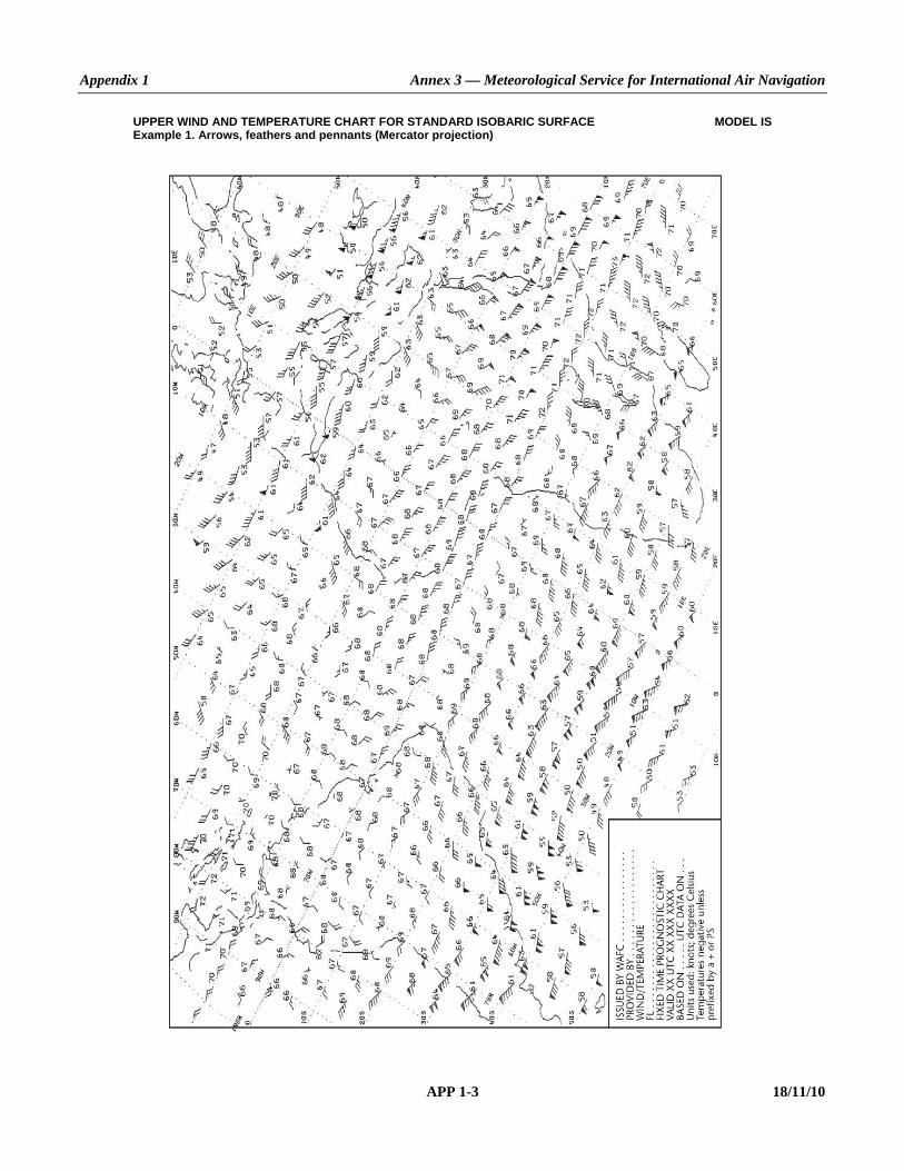
Appendix 1 Annex 3 — Meteorological Service for International Air Navigation
APP 1-3 18/11/10
UPPER WIND AND TEMPERATURE CHART FOR STANDARD ISOBARIC SURFACE MODEL IS Example 1. Arrows, feathers and pennants (Mercator projection)
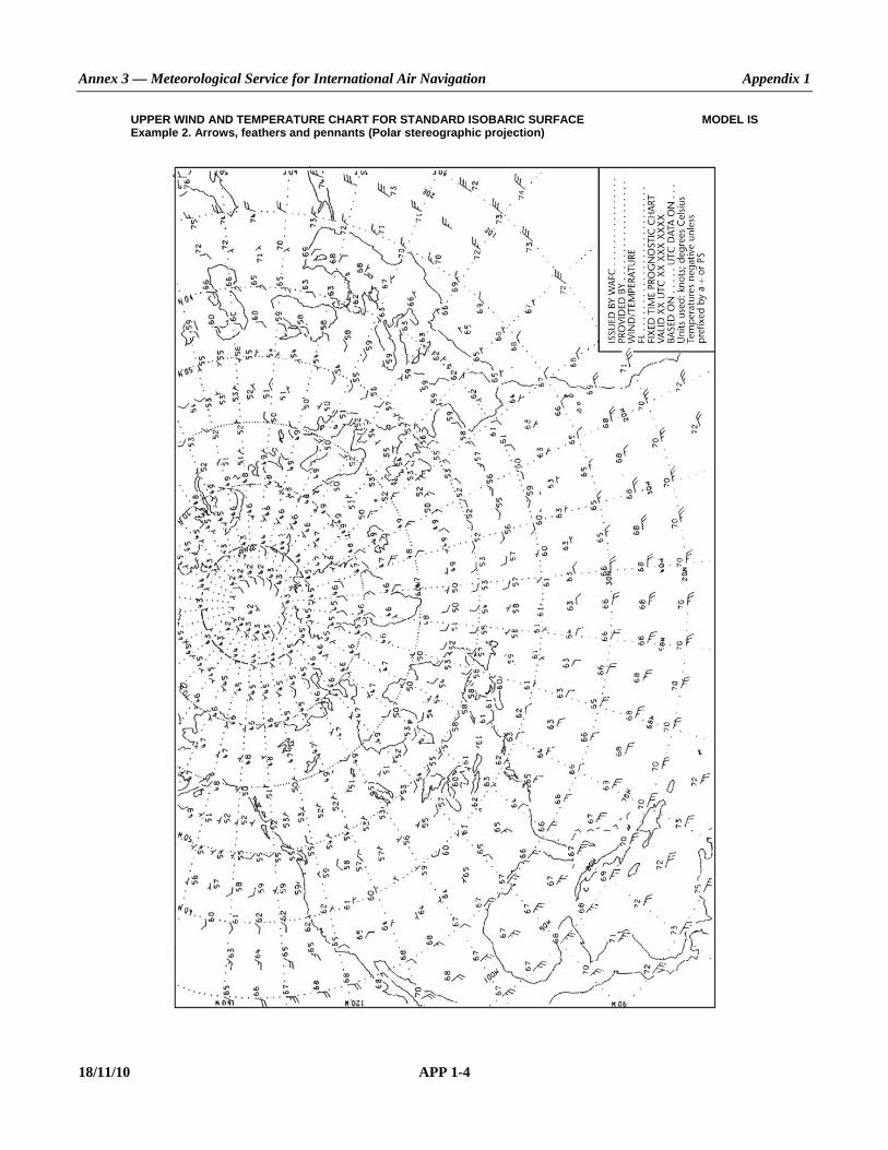
Annex 3 — Meteorological Service for International Air Navigation Appendix 1
18/11/10 APP 1-4
UPPER WIND AND TEMPERATURE CHART FOR STANDARD ISOBARIC SURFACE MODEL IS Example 2. Arrows, feathers and pennants (Polar stereographic projection)

Appendix 1 Annex 3 — Meteorological Service for International Air Navigation
APP 1-5 18/11/10
SIGNIFICANT WEATHER CHART (HIGH LEVEL) MODEL SWH Example. Polar stereographic projection (showing the jet stream vertical extent)

Annex 3 — Meteorological Service for International Air Navigation Appendix 1
18/11/10 APP 1-6
SIGNIFICANT WEATHER CHART (MEDIUM LEVEL) MODEL SWM
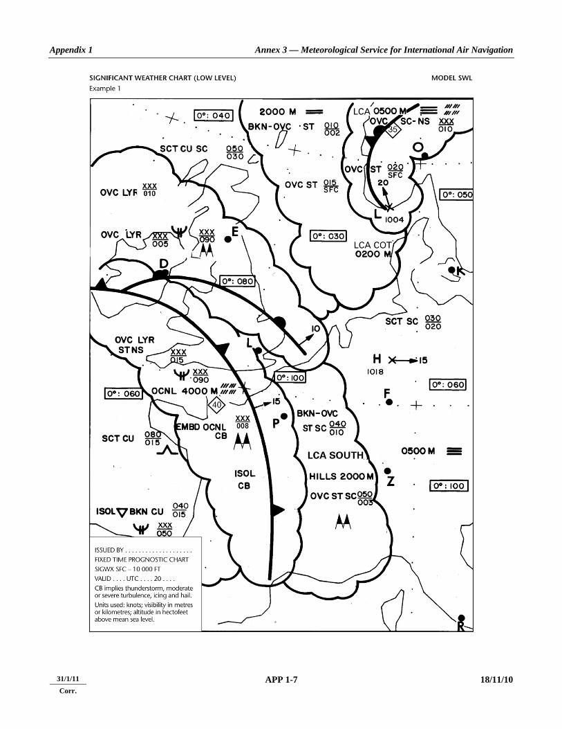
Appendix 1 Annex 3 — Meteorological Service for International Air Navigation
APP 1-7 18/11/10
31/1/11 Corr.

Annex 3 — Meteorological Service for International Air Navigation Appendix 1
18/11/10 APP 1-8
SIGNIFICANT WEATHER CHART (LOW LEVEL) MODEL SWL Example 2
31/1/11 Corr.

Appendix 1 Annex 3 — Meteorological Service for International Air Navigation
APP 1-9 18/11/10
TROPICAL CYCLONE ADVISORY INFORMATION IN GRAPHICAL FORMAT MODEL TCG

Annex 3 — Meteorological Service for International Air Navigation Appendix 1
18/11/10 APP 1-10
VOLCANIC ASH ADVISORY INFORMATION IN GRAPHICAL FORMAT MODEL VAG

Appendix 1 Annex 3 — Meteorological Service for International Air Navigation
APP 1-11 18/11/10
SIGMET FOR TROPICAL CYCLONE IN GRAPHICAL FORMAT MODEL STC

Annex 3 — Meteorological Service for International Air Navigation Appendix 1
18/11/10 APP 1-12
SIGMET FOR VOLCANIC ASH IN GRAPHICAL FORMAT MODEL SVA

Appendix 1 Annex 3 — Meteorological Service for International Air Navigation
APP 1-13 18/11/10
SIGMET FOR PHENOMENA OTHER THAN TROPICAL CYCLONE MODEL SGE AND VOLCANIC ASH IN GRAPHICAL FORMAT

Annex 3 — Meteorological Service for International Air Navigation Appendix 1
18/11/10 APP 1-14
______________________
31/1/11 Corr.

ANNEX 3 APP 2-1 18/11/10
APPENDIX 2. TECHNICAL SPECIFICATIONS RELATED TO WORLD AREA FORECAST SYSTEM
AND METEOROLOGICAL OFFICES (See Chapter 3 of this Annex.)
1. WORLD AREA FORECAST SYSTEM
1.1 Formats and codes WAFCs shall adopt uniform formats and codes for the supply of forecasts.
1.2 Upper-air gridded forecasts 1.2.1 The forecasts of upper wind; upper-air temperature; and humidity; direction, speed and flight level of maximum wind; flight level and temperature of tropopause, areas of cumulonimbus clouds, icing, clear-air and in-cloud turbulence, and geopotential altitude of flight levels shall be prepared four times a day by a WAFC and shall be valid for fixed valid times at 6, 9, 12, 15, 18, 21, 24, 27, 30, 33 and 36 hours after the time (0000, 0600, 1200 and 1800 UTC) of the synoptic data on which the forecasts were based. The dissemination of each forecast shall be in the above order and shall be completed as soon as technically feasible but not later than 6 hours after standard time of observation. 1.2.2 The grid point forecasts prepared by a WAFC shall comprise: a) wind and temperature data for flight levels 50 (850 hPa), 100 (700 hPa), 140 (600 hPa), 180 (500 hPa), 240 (400 hPa),
270 (350 hPa), 300 (300 hPa), 320 (275 hPa), 340 (250 hPa), 360 (225 hPa), 390 (200 hPa), 450 (150 hPa) and 530 (100 hPa);
b) flight level and temperature of tropopause; c) direction, speed and flight level of maximum wind; d) humidity data for flight levels 50 (850 hPa), 100 (700 hPa), 140 (600 hPa) and 180 (500 hPa); e) horizontal extent and flight levels of base and top of cumulonimbus clouds; f) icing for layers centred at flight levels 60 (800 hPa), 100 (700 hPa), 140 (600 hPa), 180 (500 hPa), 240 (400 hPa)
and 300 (300 hPa); g) clear-air turbulence for layers centred at flight levels 240 (400 hPa), 270 (350 hPa), 300 (300 hPa), 340 (250 hPa),
390 (200 hPa) and 450 (150 hPa); h) in-cloud turbulence for layers centred at flight levels 100 (700 hPa), 140 (600 hPa), 180 (500 hPa), 240 (400 hPa)
and 300 (300 hPa); and Note 1.— Forecasts referred to in e) to h) are currently of an experimental nature, labelled as“trial forecasts”
and only distributed through the Internet-based FTP services.

Annex 3 — Meteorological Service for International Air Navigation Appendix 2
18/11/10 APP 2-2
Note 2.— Layers centred at a flight level referred to in f) and h) have a depth of 100 hPa. Note 3.— Layers centred at a flight level referred to in g) have a depth of 50 hPa. i) geopotential altitude data for flight levels 50 (850 hPa), 100 (700 hPa), 140 (600 hPa), 180 (500 hPa), 240 (400 hPa),
300 (300 hPa), 320 (275 hPa), 340 (250 hPa), 360 (225 hPa), 390 (200 hPa), 450 (150 hPa) and 530 (100 hPa). 1.2.3 The foregoing grid point forecasts shall be issued by a WAFC in binary code form using the GRIB code form prescribed by WMO. Note.— The GRIB code form is contained in WMO Publication No. 306, Manual on Codes, Volume I.2, Part B — Binary Codes. 1.2.4 The foregoing grid point forecasts shall be prepared by a WAFC in a regular grid with a horizontal resolution of 1.25° of latitude and longitude.
1.3 Significant weather (SIGWX) forecasts
1.3.1 General provisions 1.3.1.1 Forecasts of significant en-route weather phenomena shall be prepared as SIGWX forecasts four times a day by a WAFC and shall be valid for fixed valid times at 24 hours after the time (0000, 0600, 1200 and 1800 UTC) of the synoptic data on which the forecasts were based. The dissemination of each forecast shall be completed as soon as technically feasible but not later than 9 hours after standard time of observation. 1.3.1.2 SIGWX forecasts shall be issued in binary code form using the BUFR code form prescribed by WMO. Note.— The BUFR code form is contained in WMO Publication No. 306, Manual on Codes, Volume I.2, Part B — Binary Codes.
1.3.2 Types of SIGWX forecasts SIGWX forecasts shall be issued as high-level SIGWX forecasts for flight levels between 250 and 630. Note.— Medium-level SIGWX forecasts for flight levels between 100 and 250 for limited geographical areas will continue to be issued until such time that flight documentation to be generated from the gridded forecasts of cumulonimbus clouds, icing and turbulence fully meets user requirements.
1.3.3 Items included in SIGWX forecasts
SIGWX forecasts shall include the following items: a) tropical cyclone provided that the maximum of the 10-minute mean surface wind speed is expected to reach or
exceed 17 m/s (34 kt); b) severe squall lines; c) moderate or severe turbulence (in cloud or clear air);

Appendix 2 Annex 3 — Meteorological Service for International Air Navigation
APP 2-3 18/11/10
d) moderate or severe icing; e) widespread sandstorm/duststorm; f) cumulonimbus clouds associated with thunderstorms and with a) to e); Note.— Non-convective cloud areas associated with in-cloud moderate or severe turbulence and/or moderate
or severe icing are to be included in the SIGWX forecasts. g) flight level of tropopause; h) jet streams; i) information on the location of volcanic eruptions that are producing ash clouds of significance to aircraft operations,
comprising: volcanic eruption symbol at the location of the volcano and, at the side of the chart, the volcano eruption symbol, the name of the volcano, latitude/longitude, the date and time of first eruption, if known, and a reference to SIGMET and NOTAM or ASHTAM issued for the area concerned; and
j) information on the location of an accidental release of radioactive materials into the atmosphere of significance to
aircraft operations, comprising: the radioactivity symbol at the site of the accident and, at the side of the chart, the radioactivity symbol, latitude/longitude of the site of the accident, date and time of the accident and a reminder to users to check NOTAM for the area concerned.
Note 1.— Medium-level SIGWX forecasts include all the items above. Note 2.— Items to be included in low-level SIGWX forecasts (i.e. flight levels below 100) are included in Appendix 5.
1.3.4 Criteria for including items in SIGWX forecasts The following criteria shall be applied for SIGWX forecasts: a) items a) to f) in 1.3.3 shall only be included if expected to occur between the lower and upper levels of the SIGWX
forecast; b) the abbreviation “CB” shall only be included when it refers to the occurrence or expected occurrence of
cumulonimbus clouds: 1) affecting an area with a maximum spatial coverage of 50 per cent or more of the area concerned; 2) along a line with little or no space between individual clouds; or 3) embedded in cloud layers or concealed by haze; c) the inclusion of “CB” shall be understood to include all weather phenomena normally associated with
cumulonimbus clouds, i.e. thunderstorm, moderate or severe icing, moderate or severe turbulence and hail; d) where a volcanic eruption or an accidental release of radioactive materials into the atmosphere warrants the
inclusion of the volcanic activity symbol or the radioactivity symbol in SIGWX forecasts, the symbols shall be included on SIGWX forecasts irrespective of the height to which the ash column or radioactive material is reported or expected to reach; and

Annex 3 — Meteorological Service for International Air Navigation Appendix 2
18/11/10 APP 2-4
e) in the case of co-incident or the partial overlapping of items a), i) and j) in 1.3.3, the highest priority shall be given to item i), followed by items j) and a). The item with the highest priority shall be placed at the location of the event, and an arrow shall be used to link the location of the other item(s) to its associated symbol or text box.
2. METEOROLOGICAL OFFICES
2.1 Use of WAFS products 2.1.1 Aerodrome meteorological offices shall use forecasts issued by the WAFCs in the preparation of flight documentation, whenever these forecasts cover the intended flight path in respect of time, altitude and geographical extent, unless otherwise agreed between the meteorological authority and the operator concerned. 2.1.2 In order to ensure uniformity and standardization of flight documentation, the WAFS GRIB and BUFR data received shall be decoded into standard WAFS charts in accordance with relevant provisions in this Annex, and the meteorological content and identification of the originator of the WAFS forecasts shall not be amended.
2.2 Notification of WAFC concerning significant discrepancies Meteorological offices using WAFS BUFR data shall notify the WAFC concerned immediately if significant discrepancies are detected or reported in respect of WAFS SIGWX forecasts concerning: a) icing, turbulence, cumulonimbus clouds that are obscured, frequent, embedded or occurring at a squall line, and
sandstorms/duststorms; and b) volcanic eruptions or an accidental release of radioactive materials into the atmosphere, of significance to aircraft
operations. The WAFC receiving the message shall acknowledge its receipt to the originator, together with a brief comment on the report and any action taken, using the same means of communication employed by the originator. Note.— Guidance on reporting significant discrepancies is provided in the Manual of Aeronautical Meteorological Practice (Doc 8896).
3. VOLCANIC ASH ADVISORY CENTRES (VAAC)
3.1 Volcanic ash advisory information 3.1.1 The advisory information on volcanic ash issued in abbreviated plain language, using approved ICAO abbreviations and numerical values of self-explanatory nature, shall be in accordance with the template shown in Table A2-1. When no approved ICAO abbreviations are available, English plain language text, to be kept to a minimum, shall be used. 3.1.2 The volcanic ash advisory information listed in Table A2-1, when prepared in graphical format, shall be as specified in Appendix 1 and issued using: a) the portable network graphics (PNG) format; or

Appendix 2 Annex 3 — Meteorological Service for International Air Navigation
APP 2-5 18/11/10
b) the BUFR code form, when exchanged in binary format. Note.— The BUFR code form is contained in WMO Publication No. 306, Manual on Codes, Volume I.2, Part B — Binary Codes.
4. STATE VOLCANO OBSERVATORIES
4.1 Information from State volcano observatories Recommendation.— The information required to be sent by State volcano observatories to their associated ACCs, MWO and VAAC should comprise: a) for significant pre-eruption volcanic activity: the date/time (UTC) of report; name and, if known, number of the
volcano; location (latitude/longitude); and description of volcanic activity; and b) for volcanic eruption: the date/time (UTC) of report and time of eruption (UTC) if different from time of report;
name and, if known, number of the volcano; location (latitude/longitude); and description of the eruption including whether an ash column was ejected and, if so, an estimate of height of ash column and the extent of any visible volcanic ash cloud, during and following an eruption.
Note.— Pre-eruption volcanic activity in this context means unusual and/or increasing volcanic activity which could presage a volcanic eruption.
5. TROPICAL CYCLONE ADVISORY CENTRES (TCAC)
5.1 Tropical cyclone advisory information 5.1.1 The advisory information on tropical cyclones shall be issued for tropical cyclones when the maximum of the 10-minute mean surface wind speed is expected to reach or exceed 17 m/s (34 kt) during the period covered by the advisory. 5.1.2 The advisory information on tropical cyclones shall be in accordance with the template shown in Table A2-2. 5.1.3 Recommendation.— The tropical cyclone advisory information listed in Table A2-2, when prepared in graphical format, should be as specified in Appendix 1 and issued using: a) the portable network graphics (PNG) format; or b) the BUFR code form, when exchanged in binary format. Note.— The BUFR code form is contained in WMO Publication No. 306, Manual on Codes, Volume I.2, Part B — Binary Codes.

Annex 3 — Meteorological Service for International Air Navigation Appendix 2
18/11/10 APP 2-6
Table A2-1. Template for advisory message for volcanic ash Key: M = inclusion mandatory, part of every message; O = inclusion optional; = = a double line indicates that the text following it should be placed on the subsequent line. Note 1.— The ranges and resolutions for the numerical elements included in advisory messages for volcanic ash are shown in Appendix 6, Table A6-4. Note 2.— The explanations for the abbreviations can be found in the Procedures for Air Navigation Services — ICAO Abbreviations and Codes (PANS-ABC, Doc 8400). Note 3.— Inclusion of a “colon” after each element heading is mandatory. Note 4.— The numbers 1 to 18 are included only for clarity and they are not part of the advisory message, as shown in the example.
Element Detailed content Template(s) Examples 1 Identification of
the type of message (M)
Type of message VA ADVISORY VA ADVISORY
2 Time of origin (M) Year, month, day, time in UTC
DTG: nnnnnnnn/nnnnZ
DTG: 20080923/0130Z
3 Name of VAAC (M)
Name of VAAC VAAC: nnnnnnnnnnnn VAAC: TOKYO
4 Name of volcano (M)
Name and IAVCEI1 number of volcano
VOLCANO: nnnnnnnnnnnnnnnnnnnnnn [nnnnnn] or UNKNOWN or UNNAMED
VOLCANO: VOLCANO:
KARYMSKY 1000-13 UNNAMED
5 Location of volcano (M)
Location of volcano in degrees and minutes
PSN: Nnnnn or Snnnn Wnnnnn or Ennnnn or UNKNOWN
PSN: PSN:
N5403 E15927 UNKNOWN
6 State or region (M)
State, or region if ash is not reported over a State
AREA: nnnnnnnnnnnnnnnn AREA: RUSSIA
7 Summit elevation (M)
Summit elevation in m (or ft)
SUMMIT ELEV: nnnnM (or nnnnnFT) SUMMIT ELEV: 1536M
8 Advisory number (M)
Advisory number: year in full and message number (separate sequence for each volcano)
ADVISORY NR: nnnn/nnnn ADVISORY NR: 2008/4
9 Information source (M)
Information source using free text
INFO SOURCE: Free text up to 32 characters INFO SOURCE: MTSAT-1R KVERT KEMSD
10 Colour code (O) Aviation colour code AVIATION COLOUR CODE:
RED or ORANGE or YELLOW or GREEN or UNKNOWN or NOT GIVEN or NIL
AVIATION COLOUR CODE:
RED
11 Eruption details (M)
Eruption details (including date/time of eruption(s))
ERUPTION DETAILS: Free text up to 64 characters or UNKNOWN
ERUPTION DETAILS:
ERUPTION AT 20080923/0000Z FL300 REPORTED

Appendix 2 Annex 3 — Meteorological Service for International Air Navigation
APP 2-7 18/11/10
Element Detailed content Template(s) Examples 12 Time of
observation of ash (M)
Day and time (in UTC) of observation of volcanic ash
OBS VA DTG: nn/nnnnZ OBS VA DTG: 23/0100Z
13 Observed or estimated ash cloud (M)
Horizontal (in degrees and minutes) and vertical extent at the time of observation of the observed or estimated ash cloud or, if the base is unknown, the top of the observed or estimated ash cloud; Movement of the observed or estimated ash cloud
OBS VA CLD or EST VA CLD:
TOP FLnnn or SFC/FLnnn or FLnnn/nnn [nnKM WID LINE2 BTN (nnNM WID LINE BTN)] Nnn[nn] or Snn[nn] Wnnn[nn] or Ennn[nn] – Nnn[nn] or Snn[nn] Wnnn[nn] or Ennn[nn][ – Nnn[nn] or Snn[nn] Wnnn[nn] or Ennn[nn] – Nnn[nn] or Snn[nn] Wnnn[nn] or Ennn[nn] – Nnn[nn] or Snn[nn] Wnnn[nn] or Ennn[nn]]3 or TOP FLnnn or SFC/FLnnn or FLnnn/nnn MOV N nnKMH (or KT) or MOV NE nnKMH (or KT) or MOV E nnKMH (or KT) or MOV SE nnKMH (or KT) or MOV S nnKMH (or KT) or MOV SW nnKMH (or KT) or MOV W nnKMH (or KT) or MOV NW nnKMH (or KT)4 or VA NOT IDENTIFIABLE FM SATELLITE DATA WIND FLnnn/nnn nnn/nn[n]MPS (or KT)4 or WIND FLnnn/nnn VRBnnMPS (or KT) or WIND SFC/FLnnn nnn/nn[n]MPS (or KT) or WIND SFC/FLnnn VRBnnMPS (or KT)
OBS VA CLD: FL250/300 N5400 E15930 – N5400 E16100 – N5300 E15945 MOV SE 20KT SFC/FL200 N5130 E16130 – N5130 E16230 – N5230 E16230 – N5230 E16130 MOV SE 15KT TOP FL240 MOV W 40KMH VA NOT IDENTIFIABLE FM SATELLITE DATA WIND FL050/070 180/12MPS
14 Forecast height and position of the ash clouds (+6 HR) (M)
Day and time (in UTC) (6 hours from the “Time of observation of ash” given in Item 12); Forecast height and position (in degrees and minutes) for each cloud mass for that fixed valid time
FCST VA CLD +6 HR:
nn/nnnnZ SFC or FLnnn/[FL]nnn [nnKM WID LINE2 BTN (nnNM WID LINE BTN)] Nnn[nn] or Snn[nn] Wnnn[nn] or Ennn[nn] – Nnn[nn] or Snn[nn] Wnnn[nn] or Ennn[nn][ – Nnn[nn] or Snn[nn] Wnnn[nn] or Ennn[nn] – Nnn[nn] or Snn[nn] Wnnn[nn] or Ennn[nn] – Nnn[nn] or Snn[nn] Wnnn[nn] or Ennn[nn]]3 or NO VA EXP or NOT AVBL or NOT PROVIDED
FCST VA CLD +6 HR:
23/0700Z FL250/350 N5130 E16030 – N5130 E16230 – N5330 E16230 – N5330 E16030 SFC/FL180 N4830 E16330 – N4830 E16630 – N5130 E16630 – N5130 E16330 NO VA EXP NOT AVBL NOT PROVIDED

Annex 3 — Meteorological Service for International Air Navigation Appendix 2
18/11/10 APP 2-8
Element Detailed content Template(s) Examples 15 Forecast height
and position of the ash clouds (+12 HR) (M)
Day and time (in UTC) (12 hours from the “Time of observation of ash” given in Item 12); Forecast height and position (in degrees and minutes) for each cloud mass for that fixed valid time
FCST VA CLD +12 HR:
nn/nnnnZ SFC or FLnnn/[FL]nnn [nnKM WID LINE2 BTN (nnNM WID LINE BTN)] Nnn[nn] or Snn[nn] Wnnn[nn] or Ennn[nn] – Nnn[nn] or Snn[nn] Wnnn[nn] or Ennn[nn][ – Nnn[nn] or Snn[nn] Wnnn[nn] or Ennn[nn] – Nnn[nn] or Snn[nn] Wnnn[nn] or Ennn[nn] – Nnn[nn] or Snn[nn] Wnnn[nn] or Ennn[nn]]3 or NO VA EXP or NOT AVBL or NOT PROVIDED
FCST VA CLD +12 HR:
23/1300Z SFC/FL270 N4830 E16130 – N4830 E16600 – N5300 E16600 – N5300 E16130 NO VA EXP NOT AVBL NOT PROVIDED
16 Forecast height and position of the ash clouds (+18 HR) (M)
Day and time (in UTC) (18 hours from the “Time of observation of ash” given in Item 12); Forecast height and position (in degrees and minutes) for each cloud mass for that fixed valid time
FCST VA CLD +18 HR:
nn/nnnnZ SFC or FLnnn/[FL]nnn [nnKM WID LINE2 BTN (nnNM WID LINE BTN)] Nnn[nn] or Snn[nn] Wnnn[nn] or Ennn[nn] – Nnn[nn] or Snn[nn] Wnnn[nn] or Ennn[nn][ – Nnn[nn] or Snn[nn] Wnnn[nn] or Ennn[nn] – Nnn[nn] or Snn[nn] Wnnn[nn] or Ennn[nn] – Nnn[nn] or Snn[nn] Wnnn[nn] or Ennn[nn]]3 or NO VA EXP or NOT AVBL or NOT PROVIDED
FCST VA CLD +18 HR:
23/1900Z NO VA EXP NOT AVBL NOT PROVIDED
17 Remarks (M) Remarks, as necessary RMK: Free text up to 256 characters or NIL
RMK: LATEST REP FM KVERT (0120Z) INDICATES ERUPTION HAS CEASED. TWO DISPERSING VA CLD ARE EVIDENT ON SATELLITE IMAGERY NIL
18 Next advisory (M) Year, month, day and time in UTC
NXT ADVISORY: nnnnnnnn/nnnnZ or NO LATER THAN nnnnnnnn/nnnnZ or NO FURTHER ADVISORIES or WILL BE ISSUED BY nnnnnnnn/nnnnZ
NXT ADVISORY:
20080923/0730Z NO LATER THAN nnnnnnnn/nnnnZ NO FURTHER ADVISORIES WILL BE ISSUED BY nnnnnnnn/nnnnZ
Notes.— 1. International Association of Volcanology and Chemistry of the Earth’s Interior (IAVCEI). 2. A straight line between two points drawn on a map in the Mercator projection or a straight line between two points which crosses lines of longitude at a constant angle. 3. Up to 4 selected layers. 4. If ash reported (e.g. AIREP) but not identifiable from satellite data.

Appendix 2 Annex 3 — Meteorological Service for International Air Navigation
APP 2-9 18/11/10
Example A2-1. Advisory message for volcanic ash
FVFE01 RJTD 230130 VA ADVISORY DTG: 20080923/0130Z VAAC: TOKYO VOLCANO: KARYMSKY 1000-13 PSN: N5403 E15927 AREA: RUSSIA SUMMIT ELEV: 1536M ADVISORY NR: 2008/4 INFO SOURCE: MTSAT-1R KVERT KEMSD AVIATION COLOUR CODE: RED ERUPTION DETAILS: ERUPTION AT 20080923/0000Z FL300 REPORTED OBS VA DTG: 23/0100Z OBS VA CLD: FL250/300 N5400 E15930 – N5400 E16100 – N5300 E15945 MOV SE 20KT
SFC/FL200 N5130 E16130 – N5130 E16230 – N5230 E16230 – N5230 E16130 MOV SE 15KT
FCST VA CLD +6 HR: 23/0700Z FL250/350 N5130 E16030 – N5130 E16230 – N5330 E16230 – N5330 E16030 SFC/FL180 N4830 E16330 – N4830 E16630 – N5130 E16630 – N5130 E16330
FCST VA CLD +12 HR: 23/1300Z SFC/FL270 N4830 E16130 – N4830 E16600 – N5300 E16600 – N5300 E16130
FCST VA CLD +18 HR: 23/1900Z NO VA EXP RMK: LATEST REP FM KVERT (0120Z) INDICATES ERUPTION HAS CEASED.
TWO DISPERSING VA CLD ARE EVIDENT ON SATELLITE IMAGERY NXT ADVISORY: 20080923/0730Z

Annex 3 — Meteorological Service for International Air Navigation Appendix 2
18/11/10 APP 2-10
Table A2-2. Template for advisory message for tropical cyclones Key: = = a double line indicates that the text following it should be placed on the subsequent line. Note 1.— The ranges and resolutions for the numerical elements included in advisory messages for tropical cyclones are shown in Appendix 6, Table A6-4. Note 2.— The explanations for the abbreviations can be found in the Procedures for Air Navigation Services — ICAO Abbreviations and Codes (PANS-ABC, Doc 8400). Note 3.— All the elements are mandatory. Note 4.— Inclusion of a “colon” after each element heading is mandatory. Note 5.— The numbers 1 to 19 are included only for clarity and they are not part of the advisory message, as shown in the example.
Element Detailed content Template(s) Examples
1 Identification of the type of message
Type of message TC ADVISORY TC ADVISORY
2 Time of origin Year, month, day and time in UTC of issue
DTG: nnnnnnnn/nnnnZ DTG: 20040925/1600Z
3 Name of TCAC Name of TCAC (location indicator or full name)
TCAC: nnnn or nnnnnnnnnn TCAC: TCAC:
YUFO1 MIAMI
4 Name of tropical cyclone
Name of tropical cyclone or “NN” for unnamed tropical cyclone
TC: nnnnnnnnnnnn or NN TC:
GLORIA
5 Advisory number Advisory number (starting with “01” for each cyclone)
NR: nn NR: 01
6 Position of the centre
Position of the centre of the tropical cyclone (in degrees and minutes)
PSN: Nnn[nn] or Snn[nn] Wnnn[nn] or Ennn[nn]
PSN: N2706 W07306
7 Direction and speed of movement
Direction and speed of movement given in sixteen compass points and km/h (or kt), respectively, or moving slowly (< 6 km/h (3 kt)) or stationary (< 2 km/h (1 kt))
MOV: N nnKMH (or KT) or NNE nnKMH (or KT) or NE nnKMH (or KT) or ENE nnKMH (or KT) or E nnKMH (or KT) or ESE nnKMH (or KT) or SE nnKMH (or KT) or SSE nnKMH (or KT) or S nnKMH (or KT) or SSW nnKMH (or KT) or SW nnKMH (or KT) or WSW nnKMH (or KT) or W nnKMH (or KT) or WNW nnKMH (or KT) or NW nnKMH (or KT) or NNW nnKMH (or KT) or SLW or STNR
MOV: NW 20KMH
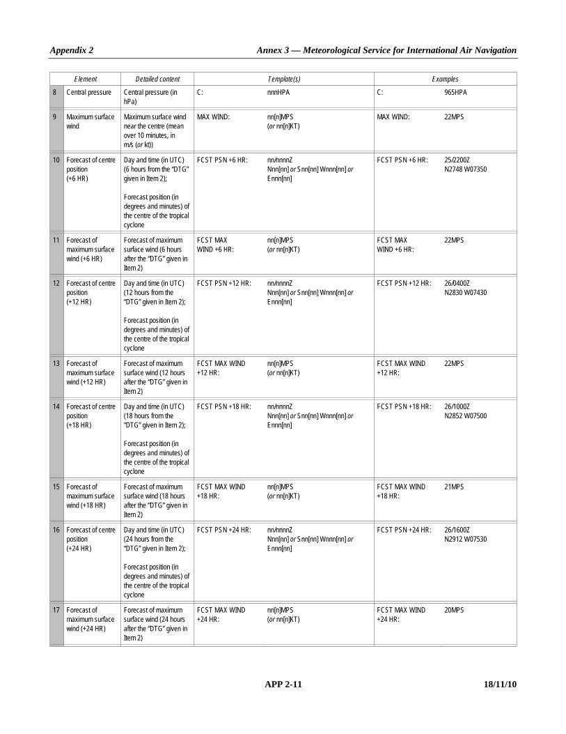
Appendix 2 Annex 3 — Meteorological Service for International Air Navigation
APP 2-11 18/11/10
Element Detailed content Template(s) Examples
8 Central pressure Central pressure (in hPa)
C: nnnHPA C: 965HPA
9 Maximum surface wind
Maximum surface wind near the centre (mean over 10 minutes, in m/s (or kt))
MAX WIND: nn[n]MPS (or nn[n]KT)
MAX WIND: 22MPS
10 Forecast of centre position (+6 HR)
Day and time (in UTC) (6 hours from the “DTG” given in Item 2); Forecast position (in degrees and minutes) of the centre of the tropical cyclone
FCST PSN +6 HR: nn/nnnnZ Nnn[nn] or Snn[nn] Wnnn[nn] or Ennn[nn]
FCST PSN +6 HR: 25/2200Z N2748 W07350
11 Forecast of maximum surface wind (+6 HR)
Forecast of maximum surface wind (6 hours after the “DTG” given in Item 2)
FCST MAX WIND +6 HR:
nn[n]MPS (or nn[n]KT)
FCST MAX WIND +6 HR:
22MPS
12 Forecast of centre position (+12 HR)
Day and time (in UTC) (12 hours from the “DTG” given in Item 2); Forecast position (in degrees and minutes) of the centre of the tropical cyclone
FCST PSN +12 HR: nn/nnnnZ Nnn[nn] or Snn[nn] Wnnn[nn] or Ennn[nn]
FCST PSN +12 HR: 26/0400Z N2830 W07430
13 Forecast of maximum surface wind (+12 HR)
Forecast of maximum surface wind (12 hours after the “DTG” given in Item 2)
FCST MAX WIND +12 HR:
nn[n]MPS (or nn[n]KT)
FCST MAX WIND +12 HR:
22MPS
14 Forecast of centre position (+18 HR)
Day and time (in UTC) (18 hours from the “DTG” given in Item 2); Forecast position (in degrees and minutes) of the centre of the tropical cyclone
FCST PSN +18 HR: nn/nnnnZ Nnn[nn] or Snn[nn] Wnnn[nn] or Ennn[nn]
FCST PSN +18 HR: 26/1000Z N2852 W07500
15 Forecast of maximum surface wind (+18 HR)
Forecast of maximum surface wind (18 hours after the “DTG” given in Item 2)
FCST MAX WIND +18 HR:
nn[n]MPS (or nn[n]KT)
FCST MAX WIND +18 HR:
21MPS
16 Forecast of centre position (+24 HR)
Day and time (in UTC) (24 hours from the “DTG” given in Item 2); Forecast position (in degrees and minutes) of the centre of the tropical cyclone
FCST PSN +24 HR: nn/nnnnZ Nnn[nn] or Snn[nn] Wnnn[nn] or Ennn[nn]
FCST PSN +24 HR: 26/1600Z N2912 W07530
17 Forecast of maximum surface wind (+24 HR)
Forecast of maximum surface wind (24 hours after the “DTG” given in Item 2)
FCST MAX WIND +24 HR:
nn[n]MPS (or nn[n]KT)
FCST MAX WIND +24 HR:
20MPS

Annex 3 — Meteorological Service for International Air Navigation Appendix 2
18/11/10 APP 2-12
Element Detailed content Template(s) Examples
18 Remarks Remarks, as necessary RMK: Free text up to 256 characters or NIL
RMK: NIL
19 Expected time of issuance of next advisory
Expected year, month, day and time (in UTC) of issuance of next advisory
NXT MSG: [BFR] nnnnnnnn/nnnnZ or NO MSG EXP
NXT MSG: 20040925/2000Z
Note.— 1. Fictitious location.
Example A2-2. Advisory message for tropical cyclones
TC ADVISORY
DTG: 20040925/1600Z TCAC: YUFO TC: GLORIA NR: 01 PSN: N2706 W07306 MOV: NW 20KMH C: 965HPA MAX WIND: 22MPS FCST PSN +6 HR: 25/2200Z N2748 W07350 FCST MAX WIND +6 HR: 22MPS FCST PSN +12 HR: 26/0400Z N2830 W07430 FCST MAX WIND +12 HR: 22MPS FCST PSN +18 HR: 26/1000Z N2852 W07500 FCST MAX WIND +18 HR: 21MPS FCST PSN +24 HR: 26/1600Z N2912 W07530 FCST MAX WIND +24 HR: 20MPS RMK: NIL NXT MSG: 20040925/2000Z
___________________

ANNEX 3 APP 3-1 18/11/10
APPENDIX 3. TECHNICAL SPECIFICATIONS RELATED TO METEOROLOGICAL OBSERVATIONS AND REPORTS
(See Chapter 4 of this Annex.)
1. GENERAL PROVISIONS RELATED TO METEOROLOGICAL OBSERVATIONS
1.1 Recommendation.— The meteorological instruments used at an aerodrome should be situated in such a way as to supply data which are representative of the area for which the measurements are required. Note.— Specifications concerning the siting of equipment and installations on operational areas, aimed at reducing the hazard to aircraft to a minimum, are contained in Annex 14, Volume I, Chapter 9. 1.2 Recommendation.— Meteorological instruments at aeronautical meteorological stations should be exposed, operated and maintained in accordance with the practices, procedures and specifications promulgated by the World Meteorological Organization. 1.3 Recommendation.— The observers at an aerodrome should be located, in so far as is practicable, so as to supply data which are representative of the area for which the observations are required. 1.4 Recommendation.— Where automated equipment forms part of an integrated semi-automatic observing system, displays of data which are made available to the local ATS units should be a subset of and displayed parallel to those available in the local meteorological service unit. In those displays, each meteorological element should be annotated to identify, as appropriate, the locations for which the element is representative.
2. GENERAL CRITERIA RELATED TO METEOROLOGICAL REPORTS
2.1 Format of meteorological reports 2.1.1 Local routine and special reports shall be issued in abbreviated plain language, in accordance with the template shown in Table A3-1. 2.1.2 METAR and SPECI shall be issued in accordance with the template shown in Table A3-2 and disseminated in the METAR and SPECI code forms prescribed by the World Meteorological Organization. Note.— The METAR and SPECI code forms are contained in WMO Publication No. 306, Manual on Codes, Volume I.1, Part A — Alphanumeric Codes. 2.1.3 Recommendation.— METAR and SPECI should be disseminated, under bilateral agreements between States in a position to do so, in the WMO BUFR code form, in addition to the dissemination of the METAR and SPECI in accordance with 2.1.2. Note.— The BUFR code form is contained in WMO Publication No. 306, Manual on Codes, Volume I.2, Part B — Binary Codes.

Annex 3 — Meteorological Service for International Air Navigation Appendix 3
18/11/10 APP 3-2
2.2 Use of CAVOK When the following conditions occur simultaneously at the time of observation: a) visibility, 10 km or more, and the lowest visibility is not reported; Note 1.— In local routine and special reports, visibility refers to the value(s) to be reported in accordance with
4.2.4.2 and 4.2.4.3; in METAR and SPECI, visibility refers to the value(s) to be reported in accordance with 4.2.4.4. Note 2.— The lowest visibility is reported in accordance with 4.2.4.4 a). b) no cloud of operational significance; c) no weather of significance to aviation as given in 4.4.2.3 and 4.4.2.6; information on visibility, runway visual range, present weather and cloud amount, cloud type and height of cloud base shall be replaced in all meteorological reports by the term “CAVOK”.
2.3 Criteria for issuance of local special reports and SPECI
2.3.1 The list of criteria for the issuance of local special reports shall include the following: a) those values which most closely correspond with the operating minima of the operators using the aerodrome; b) those values which satisfy other local requirements of the air traffic services units and of the operators; c) an increase in air temperature of 2°C or more from that given in the latest report, or an alternative threshold value as
agreed between the meteorological authority, the appropriate ATS authority and the operators concerned; d) the available supplementary information concerning the occurrence of significant meteorological conditions in the
approach and climb-out areas as given in Table A3-1; and e) those values which constitute criteria for SPECI. 2.3.2 Where required in accordance with Chapter 4, 4.4.2 b), SPECI shall be issued whenever changes in accordance with the following criteria occur: a) when the mean surface wind direction has changed by 60° or more from that given in the latest report, the mean
speed before and/or after the change being 5 m/s (10 kt) or more; b) when the mean surface wind speed has changed by 5 m/s (10 kt) or more from that given in the latest report; c) when the variation from the mean surface wind speed (gusts) has increased by 5 m/s (10 kt) or more from that at the
time of the latest report, the mean speed before and/or after the change being 7.5 m/s (15 kt) or more; d) when the onset, cessation or change in intensity of any of the following weather phenomena occurs: — freezing precipitation — moderate or heavy precipitation (including showers thereof) — thunderstorm (with precipitation);
Appendix 3 Annex 3 — Meteorological Service for International Air Navigation
APP 3-3 18/11/10
e) when the onset or cessation of any of the following weather phenomena occurs: — freezing fog — thunderstorm (without precipitation); f) when the amount of a cloud layer below 450 m (1 500 ft) changes: 1) from SCT or less to BKN or OVC; or 2) from BKN or OVC to SCT or less. 2.3.3 Recommendation.— Where required in accordance with Chapter 4, 4.4.2 b), SPECI should be issued whenever changes in accordance with the following criteria occur: a) when the wind changes through values of operational significance. The threshold values should be established by
the meteorological authority in consultation with the appropriate ATS authority and operators concerned, taking into account changes in the wind which would:
1) require a change in runway(s) in use; and 2) indicate that the runway tailwind and crosswind components have changed through values representing the
main operating limits for typical aircraft operating at the aerodrome; b) when the visibility is improving and changes to or passes through one or more of the following values, or when the
visibility is deteriorating and passes through one or more of the following values: 1) 800, 1 500 or 3 000 m; and 2) 5 000 m, in cases where significant numbers of flights are operated in accordance with the visual flight rules; Note 1.— In local special reports, visibility refers to the value(s) to be reported in accordance with 4.2.4.2 and
4.2.4.3; in SPECI, visibility refers to the value(s) to be reported in accordance with 4.2.4.4. Note 2.— Visibility refers to “prevailing visibility” except in the case where only the lowest visibility is reported
in accordance with 4.2.4.4 b). c) when the runway visual range is improving and changes to or passes through one or more of the following values,
or when the runway visual range is deteriorating and passes through one or more of the following values: 150, 350, 600 or 800 m;
d) when the onset, cessation or change in intensity of any of the following weather phenomena occurs: — duststorm — sandstorm — funnel cloud (tornado or waterspout); e) when the onset or cessation of any of the following weather phenomena occurs: — ice crystals
— low drifting dust, sand or snow — blowing dust, sand or snow — squall;

Annex 3 — Meteorological Service for International Air Navigation Appendix 3
18/11/10 APP 3-4
f) when the height of base of the lowest cloud layer of BKN or OVC extent is lifting and changes to or passes through one or more of the following values, or when the height of base of the lowest cloud layer of BKN or OVC extent is lowering and passes through one or more of the following values:
1) 30, 60, 150 or 300 m (100, 200, 500 or 1 000 ft); and 2) 450 m (1 500 ft), in cases where significant numbers of flights are operated in accordance with the visual flight
rules; g) when the sky is obscured and the vertical visibility is improving and changes to or passes through one or more of the
following values, or when the vertical visibility is deteriorating and passes through one or more of the following values: 30, 60, 150 or 300 m (100, 200, 500 or 1 000 ft); and
h) any other criteria based on local aerodrome operating minima, as agreed between the meteorological authority and
the operators. Note.— Other criteria based on local aerodrome operating minima are to be considered in parallel with similar
criteria for the inclusion of change groups and for the amendment of TAF developed in response to Appendix 5, 1.3.2 j).
2.3.4 When a deterioration of one weather element is accompanied by an improvement in another element, a single SPECI shall be issued; it shall then be treated as a deterioration report.
3. DISSEMINATION OF METEOROLOGICAL REPORTS
3.1 METAR and SPECI 3.1.1 METAR and SPECI shall be disseminated to international OPMET databanks and the centres designated by regional air navigation agreement for the operation of aeronautical fixed service satellite distribution systems, in accordance with regional air navigation agreement. 3.1.2 METAR and SPECI shall be disseminated to other aerodromes in accordance with regional air navigation agreement. 3.1.3 SPECI representing a deterioration in conditions shall be disseminated immediately after the observation. A SPECI representing a deterioration of one weather element and an improvement in another element shall be disseminated immediately after the observation. 3.1.4 Recommendation.— A SPECI representing an improvement in conditions should be disseminated only after the improvement has been maintained for 10 minutes; it should be amended before dissemination, if necessary, to indicate the conditions prevailing at the end of that 10-minute period.
3.2 Local routine and special reports 3.2.1 Local routine reports shall be transmitted to local air traffic services units and shall be made available to the operators and to other users at the aerodrome.

Appendix 3 Annex 3 — Meteorological Service for International Air Navigation
APP 3-5 18/11/10
3.2.2 Local special reports shall be transmitted to local air traffic services units as soon as the specified conditions occur. However, by agreement between the meteorological authority and the appropriate ATS authority, they need not be issued in respect of: a) any element for which there is in the local air traffic services unit a display corresponding to the one in the
meteorological station, and where arrangements are in force for the use of this display to update information included in local routine and special reports; and
b) runway visual range, when all changes of one or more steps on the reporting scale in use are being reported to the
local air traffic services unit by an observer on the aerodrome. Local special reports shall also be made available to the operators and to other users at the aerodrome.
4. OBSERVING AND REPORTING OF METEOROLOGICAL ELEMENTS
Introductory Note.— Selected criteria applicable to meteorological information referred to under 4.1 to 4.8 for inclusion in aerodrome reports are given in tabular form at Attachment C.
4.1 Surface wind
4.1.1 Siting 4.1.1.1 Recommendation.— Surface wind should be observed at a height of 10 ± 1 m (30 ± 3 ft) above the ground. 4.1.1.2 Recommendation.— Representative surface wind observations should be obtained by the use of sensors appropriately sited. Sensors for surface wind observations for local routine and special reports should be sited to give the best practicable indication of conditions along the runway and touchdown zones. At aerodromes where topography or prevalent weather conditions cause significant differences in surface wind at various sections of the runway, additional sensors should be provided. Note.— Since, in practice, the surface wind cannot be measured directly on the runway, surface wind observations for take-off and landing are expected to be the best practicable indication of the winds which an aircraft will encounter during take-off and landing.
4.1.2 Displays 4.1.2.1 Surface wind displays relating to each sensor shall be located in the meteorological station with corresponding displays in the appropriate air traffic services units. The displays in the meteorological station and in the air traffic services units shall relate to the same sensors, and where separate sensors are required as specified in 4.1.1.2, the displays shall be clearly marked to identify the runway and section of runway monitored by each sensor. 4.1.2.2 Recommendation.— The mean values of, and significant variations in, the surface wind direction and speed for each sensor should be derived and displayed by automated equipment.
4.1.3 Averaging 4.1.3.1 The averaging period for surface wind observations shall be:

Annex 3 — Meteorological Service for International Air Navigation Appendix 3
18/11/10 APP 3-6
a) 2 minutes for local routine and special reports and for wind displays in air traffic services units; and b) 10 minutes for METAR and SPECI, except that when the 10-minute period includes a marked discontinuity in the
wind direction and/or speed, only data occurring after the discontinuity shall be used for obtaining mean values; hence, the time interval in these circumstances shall be correspondingly reduced.
Note.— A marked discontinuity occurs when there is an abrupt and sustained change in wind direction of 30° or more, with a wind speed of 5 m/s (10 kt) before or after the change, or a change in wind speed of 5 m/s (10 kt) or more, lasting at least 2 minutes. 4.1.3.2 Recommendation.— The averaging period for measuring variations from the mean wind speed (gusts) reported in accordance with 4.1.5.2 c) should be 3 seconds for local routine and special reports and for METAR and SPECI and for wind displays used for depicting variations from the mean wind speed (gusts) in air traffic services units.
4.1.4 Accuracy of measurement
Recommendation.— The reported direction and speed of the mean surface wind, as well as variations from the mean surface wind, should meet the operationally desirable accuracy of measurement as given in Attachment A.
4.1.5 Reporting 4.1.5.1 In local routine and special reports and in METAR and SPECI, the surface wind direction and speed shall be reported in steps of 10 degrees true and 1 metre per second (or 1 knot), respectively. Any observed value that does not fit the reporting scale in use shall be rounded to the nearest step in the scale. 4.1.5.2 In local routine and special reports and in METAR and SPECI: a) the units of measurement used for the wind speed shall be indicated; b) variations from the mean wind direction during the past 10 minutes shall be reported as follows, if the total variation
is 60° or more: 1) when the total variation is 60° or more and less than 180° and the wind speed is 1.5 m/s (3 kt) or more, such
directional variations shall be reported as the two extreme directions between which the surface wind has varied;
2) when the total variation is 60° or more and less than 180° and the wind speed is less than 1.5 m/s (3 kt), the
wind direction shall be reported as variable with no mean wind direction; or 3) when the total variation is 180° or more, the wind direction shall be reported as variable with no mean wind
direction; c) variations from the mean wind speed (gusts) during the past 10 minutes shall be reported when the maximum wind
speed exceeds the mean speed by: 1) 2.5 m/s (5 kt) or more in local routine and special reports when noise abatement procedures are applied in
accordance with paragraph 7.2.6 of the PANS-ATM (Doc 4444); or 2) 5 m/s (10 kt) or more otherwise; d) when a wind speed of less than 0.5 m/s (1 kt) is reported, it shall be indicated as calm;

Appendix 3 Annex 3 — Meteorological Service for International Air Navigation
APP 3-7 18/11/10
e) when a wind speed of 50 m/s (100 kt) or more is reported, it shall be indicated to be more than 49 m/s (99 kt); and f) when the 10-minute period includes a marked discontinuity in the wind direction and/or speed, only variations from
the mean wind direction and mean wind speed occurring since the discontinuity shall be reported. Note.— See note under 4.1.3.1. 4.1.5.3 In local routine and special reports: a) if the surface wind is observed from more than one location along the runway, the locations for which these values
are representative shall be indicated; b) when there is more than one runway in use and the surface wind related to these runways is observed, the available
wind values for each runway shall be given, and the runways to which the values refer shall be reported; c) when variations from the mean wind direction are reported in accordance with 4.1.5.2 b) 2), the two extreme
directions between which the surface wind has varied shall be reported; and d) when variations from the mean wind speed (gusts) are reported in accordance with 4.1.5.2 c), they shall be reported
as the maximum and minimum values of the wind speed attained. 4.1.5.4 In METAR and SPECI, when variations from the mean wind speed (gusts) are reported in accordance with 4.1.5.2 c), the maximum value of the wind speed attained shall be reported.
4.2 Visibility
4.2.1 Siting 4.2.1.1 Recommendation. — When instrumented systems are used for the measurement of visibility, the visibility should be measured at a height of approximately 2.5 m (7.5 ft) above the runway. 4.2.1.2 Recommendation.— When instrumented systems are used for the measurement of visibility, representative visibility observations should be obtained by the use of sensors appropriately sited. Sensors for visibility observations for local routine and special reports should be sited to give the best practicable indications of visibility along the runway and touchdown zone.
4.2.2 Displays Recommendation.— When instrumented systems are used for the measurement of visibility, visibility displays relating to each sensor should be located in the meteorological station with corresponding displays in the appropriate air traffic services units. The displays in the meteorological station and in the air traffic services units should relate to the same sensors, and where separate sensors are required as specified in 4.2.1, the displays should be clearly marked to identify the area, e.g. runway and section of runway, monitored by each sensor.
4.2.3 Averaging Recommendation.— When instrumented systems are used for the measurement of visibility, their output should be updated at least every 60 seconds to permit provision of current representative values. The averaging period should be:

Annex 3 — Meteorological Service for International Air Navigation Appendix 3
18/11/10 APP 3-8
a) 1 minute for local routine and special reports and for visibility displays in air traffic services units; and b) 10 minutes for METAR and SPECI, except that when the 10-minute period immediately preceding the observation
includes a marked discontinuity in the visibility, only those values occurring after the discontinuity should be used for obtaining mean values.
Note.— A marked discontinuity occurs when there is an abrupt and sustained change in visibility, lasting at least 2 minutes, which reaches or passes through criteria for the issuance of SPECI reports given in 2.3.
4.2.4 Reporting 4.2.4.1 In local routine and special reports and in METAR and SPECI, the visibility shall be reported in steps of 50 m when the visibility is less than 800 m; in steps of 100 m, when it is 800 m or more but less than 5 km; in kilometre steps, when the visibility is 5 km or more but less than 10 km; and it shall be given as 10 km when the visibility is 10 km or more, except when the conditions for the use of CAVOK apply. Any observed value which does not fit the reporting scale in use shall be rounded down to the nearest lower step in the scale. Note.— Specifications concerning the use of CAVOK are given in 2.2. 4.2.4.2 In local routine and special reports, visibility along the runway(s) shall be reported together with the units of measurement used to indicate visibility. 4.2.4.3 Recommendation.— In local routine and special reports, when instrumented systems are used for the measurement of visibility: a) if the visibility is observed from more than one location along the runway as specified in Chapter 4, 4.6.2.2, the
values representative of the touchdown zone should be reported first, followed, as necessary, by the values representative of the mid-point and stop-end of the runway, and the locations for which these values are representative should be indicated; and
b) when there is more than one runway in use and the visibility is observed related to these runways, the available
visibility values for each runway should be reported, and the runways to which the values refer should be indicated. 4.2.4.4 Recommendation.— In METAR and SPECI, visibility should be reported as prevailing visibility, as defined in Chapter 1. When the visibility is not the same in different directions and a) when the lowest visibility is different from the prevailing visibility, and 1) less than 1 500 m or 2) less than 50 per
cent of the prevailing visibility and less than 5 000 m; the lowest visibility observed should also be reported and, when possible, its general direction in relation to the aerodrome reference point indicated by reference to one of the eight points of the compass. If the lowest visibility is observed in more than one direction, then the most operationally significant direction should be reported; and
b) when the visibility is fluctuating rapidly, and the prevailing visibility cannot be determined, only the lowest visibility
should be reported, with no indication of direction.
4.3 Runway visual range
4.3.1 Siting 4.3.1.1 Recommendation.— Runway visual range should be assessed at a height of approximately 2.5 m (7.5 ft) above the runway.
Appendix 3 Annex 3 — Meteorological Service for International Air Navigation
APP 3-9 18/11/10
4.3.1.2 Recommendation.— Runway visual range should be assessed at a lateral distance from the runway centre line of not more than 120 m. The site for observations to be representative of the touchdown zone should be located about 300 m along the runway from the threshold. The sites for observations to be representative of the mid-point and stop-end of the runway should be located at a distance of 1 000 to 1 500 m along the runway from the threshold and at a distance of about 300 m from the other end of the runway. The exact position of these sites and, if necessary, additional sites should be decided after considering aeronautical, meteorological and climatological factors such as long runways, swamps and other fog-prone areas.
4.3.2 Instrumented systems Note.— Since accuracy can vary from one instrument design to another, performance characteristics are to be checked before selecting an instrument for assessing RVR. The calibration of a forward-scatter meter has to be traceable and verifiable to a transmissometer standard, the accuracy of which has been verified over the intended operational range. Guidance on the use of transmissometers and forward-scatter meters in instrumented RVR systems is given in the Manual of Runway Visual Range Observing and Reporting Practices (Doc 9328). 4.3.2.1 Instrumented systems based on transmissometers or forward-scatter meters shall be used to assess runway visual range on runways intended for Category II and III instrument approach and landing operations. 4.3.2.2 Recommendation.— Instrumented systems based on transmissometers or forward-scatter meters should be used to assess runway visual range on runways intended for Category I instrument approach and landing operations.
4.3.3 Display 4.3.3.1 Where runway visual range is determined by instrumented systems, one display or more, if required, shall be located in the meteorological station with corresponding displays in the appropriate air traffic services units. The displays in the meteorological station and in the air traffic services units shall be related to the same sensors, and where separate sensors are required as specified in 4.3.1.2, the displays shall be clearly marked to identify the runway and section of runway monitored by each sensor. 4.3.3.2 Recommendation.— Where runway visual range is determined by human observers, runway visual range should be reported to the appropriate local air traffic services units, whenever there is a change in the value to be reported in accordance with the reporting scale (except where the provisions of 3.2.2 a) or b) apply). The transmission of such reports should normally be completed within 15 seconds after the termination of the observation.
4.3.4 Averaging Where instrumented systems are used for the assessment of runway visual range, their output shall be updated at least every 60 seconds to permit the provision of current, representative values. The averaging period for runway visual range values shall be: a) 1 minute for local routine and special reports and for runway visual range displays in air traffic services units; and b) 10 minutes for METAR and SPECI, except that when the 10-minute period immediately preceding the observation
includes a marked discontinuity in runway visual range values, only those values occurring after the discontinuity shall be used for obtaining mean values.
Note.— A marked discontinuity occurs when there is an abrupt and sustained change in runway visual range, lasting at least 2 minutes, which reaches or passes through the values included in criteria for the issuance of SPECI reports given in 2.3.3 c).

Annex 3 — Meteorological Service for International Air Navigation Appendix 3
18/11/10 APP 3-10
4.3.5 Runway light intensity Recommendation.— When instrumented systems are used for the assessment of runway visual range, computations should be made separately for each available runway. RVR should not be computed for a light intensity of 3 per cent or less of the maximum light intensity available on a runway. For local routine and special reports, the light intensity to be used for the computation should be: a) for a runway with the lights switched on, the light intensity actually in use on that runway; and b) for a runway with lights switched off (or at the lowest setting pending the resumption of operations), the optimum
light intensity that would be appropriate for operational use in the prevailing conditions. In METAR and SPECI, the runway visual range should be based on the maximum light intensity available on the runway. Note.— Guidance on the conversion of instrumented readings into runway visual range is given at Attachment D.
4.3.6 Reporting 4.3.6.1 In local routine and special reports and in METAR and SPECI, the runway visual range shall be reported in steps of 25 m when the runway visual range is less than 400 m; in steps of 50 m when it is between 400 m and 800 m; and in steps of 100 m when the runway visual range is more than 800 m. Any observed value which does not fit the reporting scale in use shall be rounded down to the nearest lower step in the scale. 4.3.6.2 Recommendation.— Fifty metres should be considered the lower limit and 2 000 metres the upper limit for runway visual range. Outside of these limits, local routine and special reports and METAR and SPECI should merely indicate that the runway visual range is less than 50 m or more than 2 000 m. 4.3.6.3 In local routine and special reports and in METAR and SPECI: a) when runway visual range is above the maximum value that can be determined by the system in use, it shall be
reported using the abbreviation “ABV” in local routine and special reports and the abbreviation “P” in METAR and SPECI, followed by the maximum value that can be determined by the system; and
b) when the runway visual range is below the minimum value that can be determined by the system in use, it shall be
reported using the abbreviation “BLW” in local routine and special reports and the abbreviation “M” in METAR and SPECI, followed by the minimum value that can be determined by the system.
4.3.6.4 In local routine and special reports: a) the units of measurement used shall be included; b) if runway visual range is observed from only one location along the runway, i.e. the touchdown zone, it shall be
included without any indication of location; c) if the runway visual range is observed from more than one location along the runway, the value representative of the
touchdown zone shall be reported first, followed by the values representative of the mid-point and stop-end and the locations for which these values are representative shall be indicated; and
d) when there is more than one runway in use, the available runway visual range values for each runway shall be
reported and the runways to which the values refer shall be indicated.
Appendix 3 Annex 3 — Meteorological Service for International Air Navigation
APP 3-11 18/11/10
4.3.6.5 Recommendation.— In METAR and SPECI: a) only the value representative of the touchdown zone should be reported and no indication of location on the runway
should be included; and b) where there is more than one runway available for landing, touchdown zone runway visual range values should be
included for all such runways, up to a maximum of four, and the runways to which the values refer should be indicated.
4.3.6.6 Recommendation.— In METAR and SPECI when instrumented systems are used for the assessment of runway visual range, the variations in runway visual range during the 10-minute period immediately preceding the observation should be included as follows: a) if the runway visual range values during the 10-minute period have shown a distinct tendency, such that the mean
during the first 5 minutes varies by 100 m or more from the mean during the second 5 minutes of the period, this should be indicated. When the variation of the runway visual range values shows an upward or downward tendency, this should be indicated by the abbreviation “U” or “D”, respectively. In circumstances when actual fluctuations during the 10-minute period show no distinct tendency, this should be indicated using the abbreviation “N”. When indications of tendency are not available, no abbreviations should be included; and
b) if the 1-minute runway visual range values during the 10-minute period vary from the mean value by more than
50 m or more than 20 per cent of the mean value, whichever is greater, the 1-minute mean minimum and the 1-minute mean maximum values should be reported instead of the 10-minute mean value. If the 10-minute period immediately preceding the observation includes a marked discontinuity in runway visual range values, only those values occurring after the discontinuity should be used to obtain variations.
Note.— A marked discontinuity occurs when there is an abrupt and sustained change in runway visual range, lasting at least 2 minutes, which reaches or passes through criteria for the issuance of SPECI given in 2.3.3 c).
4.4 Present weather
4.4.1 Siting Recommendation.— When instrumented systems are used for observing present weather phenomena listed under 4.4.2.3 and 4.4.2.6, representative information should be obtained by the use of sensors appropriately sited.
4.4.2 Reporting 4.4.2.1 In local routine and special reports, observed present weather phenomena shall be reported in terms of type and characteristics and qualified with respect to intensity, as appropriate. 4.4.2.2 In METAR and SPECI, observed present weather phenomena shall be reported in terms of type and character-istics and qualified with respect to intensity or proximity to the aerodrome, as appropriate. 4.4.2.3 Recommendation.— In local routine and special reports and in METAR and SPECI, the following types of present weather phenomena should be reported, using their respective abbreviations and relevant criteria, as appropriate:

Annex 3 — Meteorological Service for International Air Navigation Appendix 3
18/11/10 APP 3-12
a) Precipitation
Drizzle DZ
Rain RA
Snow SN
Snow grains SG
Ice pellets PL
Ice crystals (very small ice crystals in suspension, also known as diamond dust) IC — Reported only when associated visibility is 5 000 m or less.
Hail GR — Reported when diameter of largest hailstones is 5 mm or more.
Small hail and/or snow pellets GS — Reported when diameter of largest hailstones is less than 5 mm;
b) Obscurations (hydrometeors)
Fog FG — Reported when visibility is less than 1 000 m, except when qualified by “MI”, “BC”, “PR” or “VC” (see 4.4.2.6 and 4.4.2.7).
Mist BR — Reported when visibility is at least 1 000 m but not more than 5 000 m;
c) Obscurations (lithometeors) — The following should be used only when the obscuration consists predominantly of lithometeors and the visibility is 5 000 m or less except “SA” when qualified by “DR” (see 4.4.2.6) and volcanic ash.
Sand SA
Dust (widespread) DU
Haze HZ
Smoke FU
Volcanic ash VA
d) Other phenomena
Dust/sand whirls (dust devils) PO
Squall SQ
Funnel cloud (tornado or waterspout) FC
Duststorm DS
Sandstorm SS
4.4.2.4 Recommendation.— In automated local routine and special reports and METAR and SPECI, in addition to the precipitation types listed under 4.4.2.3 a), the abbreviation UP should be used for unidentified precipitation when the type of precipitation cannot be identified by the automatic observing system.

Appendix 3 Annex 3 — Meteorological Service for International Air Navigation
APP 3-13 18/11/10
4.4.2.5 In local routine and special reports and in METAR and SPECI, the following characteristics of present weather phenomena, as necessary, shall be reported, using their respective abbreviations and relevant criteria, as appropriate: Thunderstorm — Used to report a thunderstorm with precipitation in accordance with the templates
shown in Tables A3-1 and A3-2. When thunder is heard or lightning is detected atthe aerodrome during the 10-minute period preceding the time of observation but no precipitation is observed at the aerodrome, the abbreviation “TS” shall be usedwithout qualification.
TS
Freezing — Supercooled water droplets or precipitation, used with types of present weather
phenomena in accordance with the templates shown in Tables A3-1 and A3-2.
FZ
Note.— At aerodromes with human observers, lightning detection equipment may supplement human observations. For aerodromes with automatic observing systems, guidance on the use of lightning detection equipment intended for thunderstorm reporting is given in the Manual on Automatic Meteorological Observing Systems at Aerodromes (Doc 9837). 4.4.2.6 Recommendation.— In local routine and special reports and in METAR and SPECI, the following characteristics of present weather phenomena, as necessary, should be reported, using their respective abbreviations and relevant criteria, as appropriate: Shower — Used to report showers in accordance with the templates shown in Tables A3-1 and
A3-2. Showers observed in the vicinity of the aerodrome (see 4.4.2.7) should be reported as “VCSH” without qualification regarding type or intensity of precipitation.
SH
Blowing — Used in accordance with the templates shown in Tables A3-1 and A3-2 with types
of present weather phenomena raised by the wind to a height of 2 m (6 ft) or more above the ground.
BL
Low drifting — Used in accordance with the templates shown in Tables A3-1 and A3-2 with types
of present weather phenomena raised by the wind to less than 2 m (6 ft) above ground level.
DR
Shallow — Less than 2 m (6 ft) above ground level.
MI
Patches — Fog patches randomly covering the aerodrome.
BC
Partial — A substantial part of the aerodrome covered by fog while the remainder is clear.
PR
4.4.2.7 Recommendation.— In local routine and special reports and in METAR and SPECI, the relevant intensity or, as appropriate, the proximity to the aerodrome of the reported present weather phenomena should be indicated as follows:

Annex 3 — Meteorological Service for International Air Navigation Appendix 3
18/11/10 APP 3-14
(local routine and special reports) (METAR and SPECI) Light FBL — Moderate MOD (no indication) Heavy HVY + Used with types of present weather phenomena in accordance with the templates shown in Tables A3-1 and A3-2. Light intensity should be indicated only for precipitation.
Vicinity — Between approximately 8 and 16 km of the aerodrome reference point and used only in METAR and SPECI with present weather in accordance with the template shown in Table A3-2 when not reported under 4.4.2.6.
VC
4.4.2.8 In local routine and special reports and in METAR and SPECI: a) one or more, up to a maximum of three, of the present weather abbreviations given in 4.4.2.3 and 4.4.2.5 shall be
used, as necessary, together with an indication, where appropriate, of the characteristics and intensity or proximity to the aerodrome, so as to convey a complete description of the present weather of significance to flight operations;
b) the indication of intensity or proximity, as appropriate, shall be reported first followed respectively by the
characteristics and the type of weather phenomena; and c) where two different types of weather are observed, they shall be reported in two separate groups, where the intensity
or proximity indicator refers to the weather phenomenon which follows the indicator. However, different types of precipitation occurring at the time of observation shall be reported as one single group with the dominant type of precipitation reported first and preceded by only one intensity qualifier which refers to the intensity of the total precipitation.
4.5 Clouds
4.5.1 Siting Recommendation.— When instrumented systems are used for the measurement of the cloud amount and the height of cloud base, representative observations should be obtained by the use of sensors appropriately sited. For local routine and special reports, in the case of aerodromes with precision approach runways, sensors for cloud amount and height of cloud base should be sited to give the best practicable indications of the height of cloud base and cloud amount at the middle marker site of the instrument landing system or, at aerodromes where a middle marker beacon is not used, at a distance of 900 to 1 200 m (3 000 to 4 000 ft) from the landing threshold at the approach end of the runway. Note.— Specifications concerning the middle marker site of an instrument landing system are given in Annex 10, Volume I, Chapter 3 and at Attachment C, Table C-5.
4.5.2 Display Recommendation.— When automated equipment is used for the measurement of the height of cloud base, height of cloud base display(s) should be located in the meteorological station with corresponding display(s) in the appropriate air traffic services units. The displays in the meteorological station and in the air traffic services units should relate to the same sensor, and where separate sensors are required as specified in 4.5.1, the displays should clearly identify the area monitored by each sensor.

Appendix 3 Annex 3 — Meteorological Service for International Air Navigation
APP 3-15 18/11/10
4.5.3 Reference level The height of cloud base shall be reported above aerodrome elevation. When a precision approach runway is in use which has a threshold elevation 15 m (50 ft) or more below the aerodrome elevation, local arrangements shall be made in order that the height of cloud bases reported to arriving aircraft shall refer to the threshold elevation. In the case of reports from offshore structures, the height of cloud base shall be given above mean sea level.
4.5.4 Reporting 4.5.4.1 In local routine and special reports and in METAR and SPECI, the height of cloud base shall be reported in steps of 30 m (100 ft) up to 3 000 m (10 000 ft). Any observed value which does not fit the reporting scale in use shall be rounded down to the nearest lower step in the scale. 4.5.4.2 Recommendation.— At aerodromes where low-visibility procedures are established for approach and landing, as agreed between the meteorological authority and the appropriate ATS authority, in local routine and special reports the height of cloud base should be reported in steps of 15 m (50 ft) up to and including 90 m (300 ft) and in steps of 30 m (100 ft) between 90 m (300 ft) and 3 000 m (10 000 ft), and the vertical visibility in steps of 15 m (50 ft) up to and including 90 m (300 ft) and in steps of 30 m (100 ft) between 90 m (300 ft) and 600 m (2 000 ft). Any observed value which does not fit the reporting scale shall be rounded down to the nearest lower step in the scale. 4.5.4.3 Recommendation.— In local routine and special reports and in METAR and SPECI: a) cloud amount should be reported using the abbreviations “FEW” (1 to 2 oktas), “SCT” (3 to 4 oktas), “BKN” (5 to
7 oktas) or “OVC” (8 oktas); b) cumulonimbus clouds and towering cumulus clouds should be indicated as “CB” and “TCU”, respectively; c) the vertical visibility should be reported in steps of 30 m (100 ft) up to 600 m (2 000 ft); d) if there are no clouds of operational significance and no restriction on vertical visibility and the abbreviation
“CAVOK” is not appropriate, the abbreviation “NSC” should be used; e) when several layers or masses of cloud of operational significance are observed, their amount and height of cloud
base should be reported in increasing order of the height of cloud base, and in accordance with the following criteria:
1) the lowest layer or mass, regardless of amount to be reported as FEW, SCT, BKN or OVC as appropriate; 2) the next layer or mass, covering more than 2/8 to be reported as SCT, BKN or OVC as appropriate; 3) the next higher layer or mass, covering more than 4/8 to be reported as BKN or OVC as appropriate; and 4) cumulonimbus and/or towering cumulus clouds, whenever observed and not reported in 1) to 3); f) when the cloud base is diffuse or ragged or fluctuating rapidly, the minimum height of cloud base, or cloud
fragments, should be reported; and g) when an individual layer (mass) of cloud is composed of cumulonimbus and towering cumulus clouds with a
common cloud base, the type of cloud should be reported as cumulonimbus only. Note.— Towering cumulus indicates cumulus congestus clouds of great vertical extent. 4.5.4.4 In local routine and special reports:

Annex 3 — Meteorological Service for International Air Navigation Appendix 3
18/11/10 APP 3-16
a) the units of measurement used for the height of cloud base and vertical visibility shall be indicated; and b) when there is more than one runway in use and the heights of cloud bases are observed by instruments for these
runways, the available heights of cloud bases for each runway shall be reported and the runways to which the values refer shall be indicated.
4.5.4.5 Recommendation.— In automated local routine and special reports and METAR and SPECI: a) when the cloud type cannot be observed by the automatic observing system, the cloud type in each cloud group
should be replaced by “///”; b) when no clouds are detected by the automatic observing system, it should be indicated by using the abbreviation
“NCD”; and c) when cumulonimbus clouds or towering cumulus clouds are detected by the automatic observing system and the
cloud amount and the height of cloud base cannot be observed, the cloud amount and the height of cloud base should be replaced by “//////”.
4.6 Air temperature and dew-point temperature
4.6.1 Display Recommendation.— When automated equipment is used for the measurement of air temperature and dew-point temperature, air temperature and dew-point temperature displays should be located in the meteorological station with corresponding displays in the appropriate air traffic services units. The displays in the meteorological station and in the air traffic services units should relate to the same sensors.
4.6.2 Reporting 4.6.2.1 In local routine and special reports and in METAR and SPECI, the air temperature and the dew-point temperature shall be reported in steps of whole degrees Celsius. Any observed value which does not fit the reporting scale in use shall be rounded to the nearest whole degree Celsius, with observed values involving 0.5° rounded up to the next higher whole degree Celsius. 4.6.2.2 In local routine and special reports and in METAR and SPECI, a temperature below 0°C shall be identified.
4.7 Atmospheric pressure
4.7.1 Display When automated equipment is used for the measurement of atmospheric pressure, QNH and, if required in accordance with 4.7.3.2 b), QFE displays relating to the barometer shall be located in the meteorological station with corresponding displays in the appropriate air traffic services units. When QFE values are displayed for more than one runway, as specified in 4.7.3.2 d), the displays shall be clearly marked to identify the runway to which the QFE value displayed refers.

Appendix 3 Annex 3 — Meteorological Service for International Air Navigation
APP 3-17 18/11/10
4.7.2 Reference level Recommendation.— The reference level for the computation of QFE should be the aerodrome elevation. For non-precision approach runways, the thresholds of which are 2 m (7 ft) or more below the aerodrome elevation, and for precision approach runways, the QFE, if required, should refer to the relevant threshold elevation.
4.7.3 Reporting 4.7.3.1 For local routine and special reports and in METAR and SPECI, QNH and QFE shall be computed in tenths of hectopascals and reported therein in steps of whole hectopascals, using four digits. Any observed value which does not fit the reporting scale in use shall be rounded down to the nearest lower whole hectopascal. 4.7.3.2 In local routine and special reports: a) QNH shall be included; b) QFE shall be included if required by users or, if so agreed locally between the meteorological and air traffic services
authorities and operators concerned, on a regular basis; c) the units of measurement used for QNH and QFE values shall be included; and d) if QFE values are required for more than one runway, the required QFE values for each runway shall be reported
and the runways to which the values refer shall be indicated. 4.7.3.3 In METAR and SPECI, only QNH values shall be included.
4.8 Supplementary information
4.8.1 Reporting 4.8.1.1 Recommendation.— In local routine and special reports and in METAR and SPECI, the following recent weather phenomena, i.e. weather phenomena observed at the aerodrome during the period since the last issued routine report or last hour, whichever is the shorter, but not at the time of observation, should be reported, up to a maximum of three groups, in accordance with the templates shown in Tables A3-1 and A3-2, in the supplementary information: — freezing precipitation — moderate or heavy precipitation (including showers thereof) — blowing snow — duststorm, sandstorm — thunderstorm — funnel cloud (tornado or water spout) — volcanic ash 4.8.1.2 Recommendation.— In local routine and special reports, the following significant meteorological conditions, or combinations thereof, should be reported in supplementary information: — cumulonimbus clouds CB — thunderstorm TS — moderate or severe turbulence MOD TURB, SEV TURB
Annex 3 — Meteorological Service for International Air Navigation Appendix 3
18/11/10 APP 3-18
— wind shear WS — hail GR — severe squall line SEV SQL — moderate or severe icing MOD ICE, SEV ICE — freezing precipitation FZDZ, FZRA — severe mountain waves SEV MTW — duststorm, sandstorm DS, SS — blowing snow BLSN — funnel cloud (tornado or water spout) FC The location of the condition should be indicated. Where necessary, additional information should be included using abbreviated plain language. 4.8.1.3 Recommendation.— In automated local routine and special reports and METAR and SPECI, in addition to the recent weather phenomena listed under 4.8.1.1, recent unknown precipitation should be reported in accordance with the template shown in Table A3-2 when the type of precipitation cannot be identified by the automatic observing system. 4.8.1.4 Recommendation.— In METAR and SPECI, where local circumstances so warrant, information on wind shear should be added. Note.— The local circumstances referred to in 4.8.1.4 include, but are not necessarily limited to, wind shear of a non-transitory nature such as might be associated with low-level temperature inversions or local topography. 4.8.1.5 Recommendation.— In METAR and SPECI, the following information should be included in the supplementary information, in accordance with regional air navigation agreement: a) information on sea-surface temperature and the state of the sea from aeronautical meteorological stations
established on offshore structures in support of helicopter operations; and b) information on the state of the runway provided by the appropriate airport authority. Note 1.— The state of the sea is specified in WMO Publication No. 306, Manual on Codes, Volume I.1, Part A — Alphanumeric Codes, Code Table 3700. Note 2.— The state of the runway is specified in WMO Publication No. 306, Manual on Codes, Volume I.1, Part A — Alphanumeric Codes, Code Tables 0366, 0519, 0919 and 1079.

Appendix 3 Annex 3 — Meteorological Service for International Air Navigation
APP 3-19 18/11/10
Table A3-1. Template for the local routine (MET REPORT) and local special (SPECIAL) reports Key: M = inclusion mandatory, part of every message; C = inclusion conditional, dependent on meteorological conditions; O = inclusion optional. Note 1.— The ranges and resolutions for the numerical elements included in the local routine and special reports are shown in Table A3-4 of this appendix. Note 2.— The explanations for the abbreviations can be found in the Procedures for Air Navigation Services — ICAO Abbreviations and Codes (PANS-ABC, Doc 8400).
Element as specified in Chapter 4 Detailed content Template(s) Examples
Identification of the type of report (M)
Type of report MET REPORT or SPECIAL MET REPORT SPECIAL
Location indicator (M) ICAO location indicator (M) nnnn YUDO1
Time of the observation (M)
Day and actual time of the observation in UTC
nnnnnnZ 221630Z
Identification of an automated report (C)
Automated report identifier (C)
AUTO AUTO
Surface wind (M) Name of the element (M) WIND WIND 240/4MPS (WIND 240/8KT)
Runway (O)2 RWY nn[L] or RWY nn[C] or RWY nn[R] WIND RWY 18 TDZ 190/6MPS (WIND RWY 18 TDZ 190/12KT) Runway section (O)3 TDZ
Wind direction (M) nnn/ VRB BTN nnn/ AND nnn/ or VRB
C A L M
WIND VRB1MPS WIND CALM (WIND VRB2KT) WIND VRB BTN 350/ AND 050/1MPS (WIND VRB BTN 350/ AND 050/2KT)
Wind speed (M) [ABV]n[n][n]MPS (or [ABV]n[n]KT) WIND 270/ABV49MPS (WIND 270/ABV99KT)
Significant speed variations (C)4
MAX[ABV]nn[n] MNMn[n] WIND 120/3MPS MAX9 MNM2 (WIND 120/6KT MAX18 MNM4)
Significant directional variations (C)5
VRB BTN nnn/ AND nnn/
— WIND 020/5MPS VRB BTN 350/ AND 070/ (WIND 020/10KT VRB BTN 350/ AND 070/)
Runway section (O)3 MID WIND RWY 14R MID 140/6MPS (WIND RWY 14R MID 140/12KT) Wind direction (O)3 nnn/ VRB BTN nnn/ AND nnn/
or VRB
C A L M Wind speed (O)3 [ABV]n[n][n]MPS (or [ABV]n[n]KT)
Significant speed variations (C)4
MAX[ABV]nn[n] MNMn[n]
Significant directional variations (C)5
VRB BTN nnn/ AND nnn/
—
Runway section (O)3 END WIND RWY 27 TDZ 240/8MPS MAX14 MNM5 END 250/7MPS (WIND RWY 27 TDZ 240/16KT MAX28 MNM10 END 250/14KT)
Wind direction (O)3 nnn/ VRB BTN nnn/ AND nnn/ or VRB
C A L M Wind speed (O)3 [ABV]n[n][n]MPS (or [ABV]n[n]KT)

Annex 3 — Meteorological Service for International Air Navigation Appendix 3
18/11/10 APP 3-20
Element as specified in Chapter 4 Detailed content Template(s) Examples
Significant speed variations (C)4
MAX[ABV]nn[n] MNMn[n]
Significant directional variations (C)5
VRB BTN nnn/ AND nnn/
—
Visibility (M) Name of the element (M) VIS C A V O K
VIS 350M CAVOK VIS 7KM VIS 10KM
Runway (O)2 RWY nn[L] or RWY nn[C] or RWY nn[R] VIS RWY 09 TDZ 800M END 1200M
Runway section (O)3 TDZ
Visibility (M) nn[n][n]M or n[n]KM
Runway section (O)3 MID
Visibility (O)3 nn[n][n]M or n[n]KM
Runway section (O)3 END VIS RWY 18C TDZ 6KM RWY 27 TDZ 4000M
Visibility (O)3 nn[n][n]M or n[n]KM
RVR (C)6 Name of the element (M) RVR RVR RWY 32 400M RVR RWY 20 1600M
Runway (C)7 RWY nn[L] or RWY nn[C] or RWY nn[R]
Runway section (C)8 TDZ
RVR (M) [ABV or BLW] nn[n][n]M RVR RWY 10L BLW 50M RVR RWY 14 ABV 2000M RVR RWY 10 BLW 150M RVR RWY 12 ABV 1200M
Runway section (C)8 MID RVR RWY 12 TDZ 1100M MID ABV 1400M
RVR (C)8 [ABV or BLW] nn[n][n]M
Runway section (C)8 END RVR RWY 16 TDZ 600M MID 500M END 400M RVR RWY 26 500M RWY 20 800M RVR (C)8 [ABV or BLW] nn[n][n]M
Present weather (C)9, 10 Intensity of present weather (C)9
FBL or MOD or HVY
—
Characteristics and type of present weather (C)9,11
DZ or RA or SN or SG or PL or DS or SS or FZDZ or FZUP12 or FC13 or FZRA or SHGR or SHGS or SHRA or SHSN or SHUP12 or TSGR or TSGS or TSRA or TSSN or TSUP12 or UP12
IC or FG or BR or SA or DU or HZ or FU or VA or SQ or PO or FC or TS or BCFG or BLDU or BLSA or BLSN or DRDU or DRSA or DRSN or FZFG or MIFG or PRFG
MOD RA HZ HVY TSRA FG HVY DZ VA FBL SN MIFG HVY TSRASN FBL SNRA FBL DZ FG HVY SHSN BLSN HVY TSUP
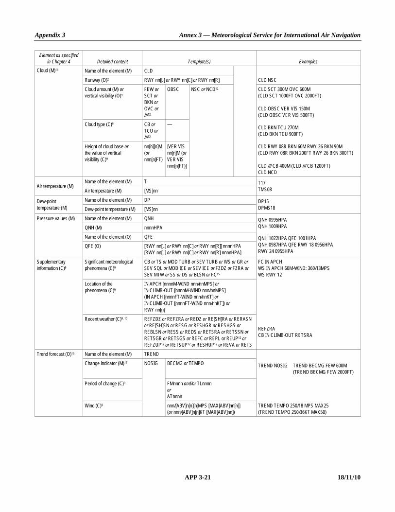
Appendix 3 Annex 3 — Meteorological Service for International Air Navigation
APP 3-21 18/11/10
Element as specified in Chapter 4 Detailed content Template(s) Examples
Cloud (M)14 Name of the element (M) CLD
Runway (O)2 RWY nn[L] or RWY nn[C] or RWY nn[R] CLD NSC
Cloud amount (M) or vertical visibility (O)9
FEW or SCT or BKN or OVC or ///12
OBSC NSC or NCD12 CLD SCT 300M OVC 600M (CLD SCT 1000FT OVC 2000FT) CLD OBSC VER VIS 150M (CLD OBSC VER VIS 500FT)
Cloud type (C)9 CB or TCU or ///12
— CLD BKN TCU 270M (CLD BKN TCU 900FT)
Height of cloud base or the value of vertical visibility (C)9
nn[n][n]M (or nnn[n]FT)
[VER VIS nn[n]M (or VER VIS nnn[n]FT)]
CLD RWY 08R BKN 60M RWY 26 BKN 90M (CLD RWY 08R BKN 200FT RWY 26 BKN 300FT) CLD /// CB 400M (CLD /// CB 1200FT) CLD NCD
Air temperature (M) Name of the element (M) T T17
TMS08 Air temperature (M) [MS]nn
Dew-point temperature (M)
Name of the element (M) DP DP15 DPMS18 Dew-point temperature (M) [MS]nn
Pressure values (M) Name of the element (M) QNH QNH 0995HPA QNH 1009HPA QNH (M) nnnnHPA
Name of the element (O) QFE QNH 1022HPA QFE 1001HPA QNH 0987HPA QFE RWY 18 0956HPA RWY 24 0955HPA
QFE (O) [RWY nn[L] or RWY nn[C] or RWY nn[R]] nnnnHPA [RWY nn[L] or RWY nn[C] or RWY nn[R] nnnnHPA]
Supplementary information (C)9
Significant meteorological phenomena (C)9
CB or TS or MOD TURB or SEV TURB or WS or GR or SEV SQL or MOD ICE or SEV ICE or FZDZ or FZRA or SEV MTW or SS or DS or BLSN or FC15
FC IN APCH WS IN APCH 60M-WIND: 360/13MPS WS RWY 12
Location of the phenomena (C)9
IN APCH [nnnnM-WIND nnn/nnMPS] or IN CLIMB-OUT [nnnnM-WIND nnn/nnMPS] (IN APCH [nnnnFT-WIND nnn/nnKT] or IN CLIMB-OUT [nnnnFT-WIND nnn/nnKT]) or RWY nn[n]
Recent weather (C)9, 10 REFZDZ or REFZRA or REDZ or RE[SH]RA or RERASN or RE[SH]SN or RESG or RESHGR or RESHGS or REBLSN or RESS or REDS or RETSRA or RETSSN or RETSGR or RETSGS or REFC or REPL or REUP12 or REFZUP12 or RETSUP12 or RESHUP12 or REVA or RETS
REFZRA CB IN CLIMB-OUT RETSRA
Trend forecast (O)16 Name of the element (M) TREND
Change indicator (M)17 NOSIG BECMG or TEMPO TREND NOSIG TREND BECMG FEW 600M (TREND BECMG FEW 2000FT)
Period of change (C)9 FMnnnn and/or TLnnnn or ATnnnn
Wind (C)9 nnn/[ABV]n[n][n]MPS [MAX[ABV]nn[n]] (or nnn/[ABV]n[n]KT [MAX[ABV]nn])
TREND TEMPO 250/18 MPS MAX25 (TREND TEMPO 250/36KT MAX50)

Annex 3 — Meteorological Service for International Air Navigation Appendix 3
18/11/10 APP 3-22
Element as specified in Chapter 4 Detailed content Template(s) Examples
Visibility (C)9 VIS nn[n][n]M or VIS n[n]KM
C A V O K
TREND BECMG AT1800 VIS 10KM NSW TREND BECMG TL1700 VIS 800M FG TREND BECMG FM1030 TL1130 CAVOK
Weather phenomenon: intensity (C)9
FBL or MOD or HVY
— NSW TREND TEMPO TL1200 VIS 600M BECMG AT1230 VIS 8KM NSW CLD NSC
Weather phenomenon: characteristics and type (C)9, 10, 11
DZ or RA or SN or SG or PL or DS or SS or FZDZ or FZRA or SHGR or SHGS or SHRA or SHSN or TSGR or TSGS or TSRA or TSSN
IC or FG or BR or SA or DU or HZ or FU or VA or SQ or PO or FC or TS or BCFG or BLDU or BLSA or BLSN or DRDU or DRSA or DRSN or FZFG or MIFG or PRFG
TREND TEMPO FM0300 TL0430 MOD FZRA TREND BECMG FM1900 VIS 500M HVY SNRA TREND BECMG FM1100 MOD SN TEMPO FM1130 BLSN
Name of the element (C)9 CLD
Cloud amount and vertical visibility (C)9
FEW or SCT or BKN or OVC
OBSC NSC TREND BECMG AT1130 CLD OVC 300M (TREND BECMG AT1130 CLD OVC 1000FT)
Cloud type (C)9 CB or TCU
— TREND TEMPO TL1530 HVY SHRA CLD BKN CB 360M (TREND TEMPO TL1530 HVY SHRA CLD BKN CB 1200FT)
Height of cloud base or the value of vertical visibility (C)9
nn[n][n]M (or nnn[n]FT)
[VER VIS nn[n]M (or VER VIS nnn[n]FT)]
Notes.— 1. Fictitious location. 2. Optional values for one or more runways. 3. Optional values for one or more sections of the runway. 4. To be included in accordance with 4.1.5.2 c). 5. To be included in accordance with 4.1.5.2 b) 1). 6. To be included if visibility or RVR < 1 500 m. 7. To be included in accordance with 4.3.6.4 d). 8. To be included in accordance with 4.3.6.4 c). 9. To be included whenever applicable. 10. One or more, up to a maximum of three groups, in accordance with 4.4.2.8 a), 4.8.1.1 and Appendix 5, 2.2.4.3. 11. Precipitation types listed under 4.4.2.3 a) may be combined in accordance with 4.4.2.8 c) and Appendix 5, 2.2.4.1. Only moderate or heavy precipitation to be indicated
in trend forecasts in accordance with Appendix 5, 2.2.4.1. 12. For automated reports only. 13. Heavy used to indicate tornado or waterspout; moderate used to indicate funnel cloud not reaching the ground. 14. Up to four cloud layers in accordance with 4.5.4.3 e). 15. Abbreviated plain language may be used in accordance with 4.8.1.2. 16. To be included in accordance with Chapter 6, 6.3.2. 17. Number of change indicators to be kept to a minimum in accordance with Appendix 5, 2.2.1, normally not exceeding three groups.
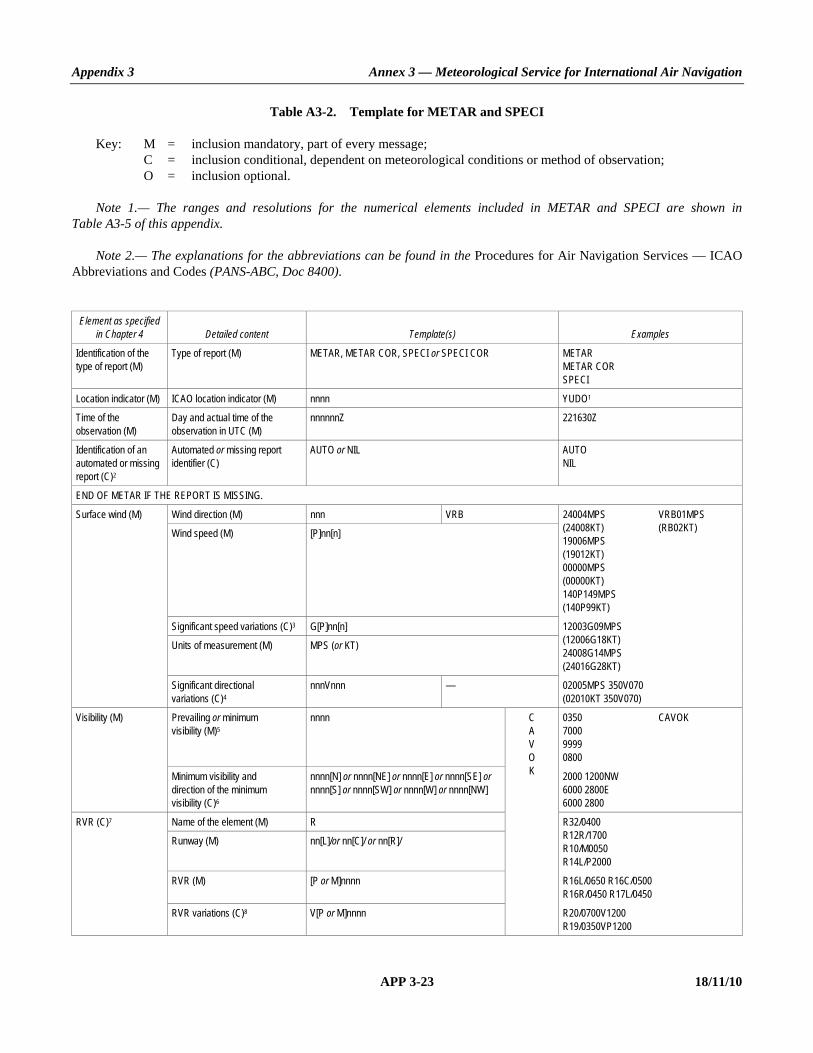
Appendix 3 Annex 3 — Meteorological Service for International Air Navigation
APP 3-23 18/11/10
Table A3-2. Template for METAR and SPECI Key: M = inclusion mandatory, part of every message; C = inclusion conditional, dependent on meteorological conditions or method of observation; O = inclusion optional. Note 1.— The ranges and resolutions for the numerical elements included in METAR and SPECI are shown in Table A3-5 of this appendix. Note 2.— The explanations for the abbreviations can be found in the Procedures for Air Navigation Services — ICAO Abbreviations and Codes (PANS-ABC, Doc 8400).
Element as specified in Chapter 4 Detailed content Template(s) Examples
Identification of the type of report (M)
Type of report (M) METAR, METAR COR, SPECI or SPECI COR METAR METAR COR SPECI
Location indicator (M) ICAO location indicator (M) nnnn YUDO1
Time of the observation (M)
Day and actual time of the observation in UTC (M)
nnnnnnZ 221630Z
Identification of an automated or missing report (C)2
Automated or missing report identifier (C)
AUTO or NIL AUTO NIL
END OF METAR IF THE REPORT IS MISSING.
Surface wind (M) Wind direction (M) nnn VRB 24004MPS VRB01MPS (24008KT) (RB02KT) 19006MPS (19012KT) 00000MPS (00000KT) 140P149MPS (140P99KT)
Wind speed (M) [P]nn[n]
Significant speed variations (C)3 G[P]nn[n] 12003G09MPS (12006G18KT) 24008G14MPS (24016G28KT)
Units of measurement (M) MPS (or KT)
Significant directional variations (C)4
nnnVnnn — 02005MPS 350V070 (02010KT 350V070)
Visibility (M) Prevailing or minimum visibility (M)5
nnnn C A V O K
0350 CAVOK 7000 9999 0800
Minimum visibility and direction of the minimum visibility (C)6
nnnn[N] or nnnn[NE] or nnnn[E] or nnnn[SE] or nnnn[S] or nnnn[SW] or nnnn[W] or nnnn[NW]
2000 1200NW 6000 2800E 6000 2800
RVR (C)7 Name of the element (M) R R32/0400 R12R/1700 R10/M0050 R14L/P2000
Runway (M) nn[L]/or nn[C]/ or nn[R]/
RVR (M) [P or M]nnnn R16L/0650 R16C/0500 R16R/0450 R17L/0450
RVR variations (C)8 V[P or M]nnnn R20/0700V1200 R19/0350VP1200
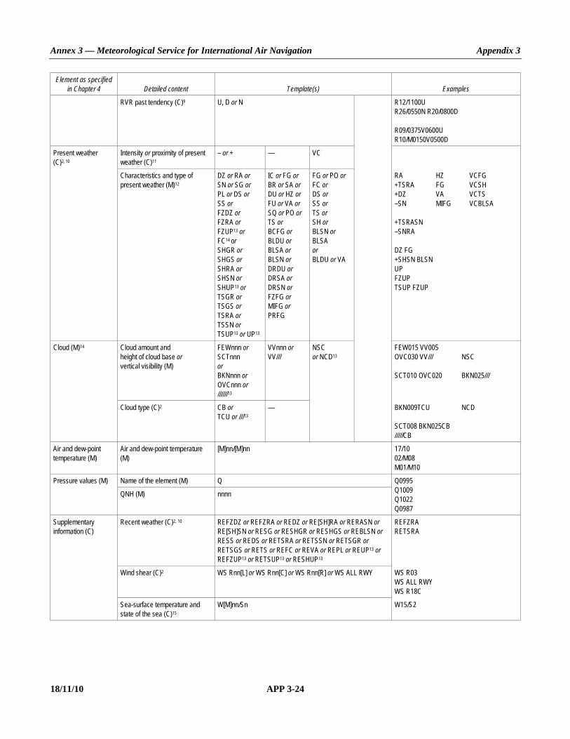
Annex 3 — Meteorological Service for International Air Navigation Appendix 3
18/11/10 APP 3-24
Element as specified in Chapter 4 Detailed content Template(s) Examples
RVR past tendency (C)9 U, D or N R12/1100U R26/0550N R20/0800D R09/0375V0600U R10/M0150V0500D
Present weather (C)2, 10
Intensity or proximity of present weather (C)11
– or + — VC
Characteristics and type of present weather (M)12
DZ or RA or SN or SG or PL or DS or SS or FZDZ or FZRA or FZUP13 or FC14 or SHGR or SHGS or SHRA or SHSN or SHUP13 or TSGR or TSGS or TSRA or TSSN or TSUP13 or UP13
IC or FG or BR or SA or DU or HZ or FU or VA or SQ or PO or TS or BCFG or BLDU or BLSA or BLSN or DRDU or DRSA or DRSN or FZFG or MIFG or PRFG
FG or PO or FC or DS or SS or TS or SH or BLSN or BLSA or BLDU or VA
RA HZ VCFG +TSRA FG VCSH +DZ VA VCTS –SN MIFG VCBLSA +TSRASN –SNRA DZ FG +SHSN BLSN UP FZUP TSUP FZUP
Cloud (M)14 Cloud amount and height of cloud base or vertical visibility (M)
FEWnnn or SCTnnn or BKNnnn or OVCnnn or //////13
VVnnn or VV///
NSC or NCD13
FEW015 VV005 OVC030 VV/// NSC SCT010 OVC020 BKN025///
Cloud type (C)2 CB or TCU or ///13
— BKN009TCU NCD SCT008 BKN025CB /////CB
Air and dew-point temperature (M)
Air and dew-point temperature (M)
[M]nn/[M]nn 17/10 02/M08 M01/M10
Pressure values (M) Name of the element (M) Q Q0995 Q1009 Q1022 Q0987
QNH (M) nnnn
Supplementary information (C)
Recent weather (C)2, 10 REFZDZ or REFZRA or REDZ or RE[SH]RA or RERASN or RE[SH]SN or RESG or RESHGR or RESHGS or REBLSN or RESS or REDS or RETSRA or RETSSN or RETSGR or RETSGS or RETS or REFC or REVA or REPL or REUP13 or REFZUP13 or RETSUP13 or RESHUP13
REFZRA RETSRA
Wind shear (C)2 WS Rnn[L] or WS Rnn[C] or WS Rnn[R] or WS ALL RWY WS R03 WS ALL RWY WS R18C
Sea-surface temperature and state of the sea (C)15
W[M]nn/Sn W15/S2

Appendix 3 Annex 3 — Meteorological Service for International Air Navigation
APP 3-25 18/11/10
Element as specified in Chapter 4 Detailed content Template(s) Examples
State of the runway (C)16
Runway designator (M)
R nn[L]/ or Rnn[C]/ or Rnn[R]/ R/SNOCLO R99/421594 R/SNOCLO R14L/CLRD// Runway deposits (M) n or / CLRD//
Extent of runway contamination (M)
n or /
Depth of deposit (M) nn or //
Friction coefficient or braking action (M)
nn or //
Trend forecast (O)17 Change indicator (M)18 NOSIG BECMG or TEMPO NOSIG BECMG FEW020 TEMPO 25018G25MPS (TEMPO 25036G50KT) BECMG FM1030 TL1130 CAVOK BECMG TL1700 0800 FG BECMG AT1800 9000 NSW BECMG FM1900 0500 +SNRA BECMG FM1100 SN TEMPO FM1130 BLSN TEMPO FM0330 TL0430 FZRA
Period of change (C)2 FMnnnn and/or TLnnnn or ATnnnn
Wind (C)2 nnn[P]nn[n][G[P]nn[n]]MPS (or nnn[P]nn[G[P]nn]KT)
Prevailing visibility (C)2 nnnn C A V O K
Weather phenomenon: intensity (C)11
– or + — N S W
Weather phenomenon: characteristics and type (C)2, 10, 12
DZ or RA or SN or SG or PL or DS or SS or FZDZ or FZRA or SHGR or SHGS or SHRA or SHSN or TSGR or TSGS or TSRA or TSSN
IC or FG or BR or SA or DU or HZ or FU or VA or SQ or PO or FC or TS or BCFG or BLDU or BLSA or BLSN or DRDU or DRSA or DRSN or FZFG or MIFG or PRFG
Cloud amount and height of cloud base or vertical visibility (C)2
FEWnnn or SCTnnn or BKNnnn or OVCnnn
VVnnn or VV///
N S C
TEMPO TL1200 0600 BECMG AT1200 8000 NSW NSC BECMG AT1130 OVC010
Cloud type (C)2 CB or TCU — TEMPO TL1530 +SHRA BKN012CB
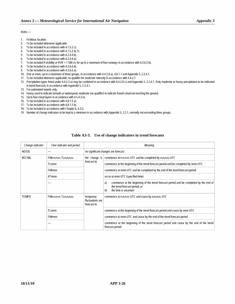
Annex 3 — Meteorological Service for International Air Navigation Appendix 3
18/11/10 APP 3-26
Notes.— 1. Fictitious location. 2. To be included whenever applicable. 3. To be included in accordance with 4.1.5.2 c). 4. To be included in accordance with 4.1.5.2 b) 1). 5. To be included in accordance with 4.2.4.4 b). 6. To be included in accordance with 4.2.4.4 a). 7. To be included if visibility or RVR < 1 500 m; for up to a maximum of four runways in accordance with 4.3.6.5 b). 8. To be included in accordance with 4.3.6.6 b). 9. To be included in accordance with 4.3.6.6 a). 10. One or more, up to a maximum of three groups, in accordance with 4.4.2.8 a), 4.8.1.1 and Appendix 5, 2.2.4.1. 11. To be included whenever applicable; no qualifier for moderate intensity in accordance with 4.4.2.7. 12. Precipitation types listed under 4.4.2.3 a) may be combined in accordance with 4.4.2.8 c) and Appendix 5, 2.2.4.1. Only moderate or heavy precipitation to be indicated
in trend forecasts in accordance with Appendix 5, 2.2.4.1. 13. For automated reports only. 14. Heavy used to indicate tornado or waterspout; moderate (no qualifier) to indicate funnel cloud not reaching the ground. 15. Up to four cloud layers in accordance with 4.5.4.3 e). 16. To be included in accordance with 4.8.1.5 a). 17. To be included in accordance with 4.8.1.5 b). 18. To be included in accordance with Chapter 6, 6.3.2. 19. Number of change indicators to be kept to a minimum in accordance with Appendix 5, 2.2.1, normally not exceeding three groups.
Table A3-3. Use of change indicators in trend forecasts
Change indicator Time indicator and period Meaning
NOSIG — no significant changes are forecast
BECMG FMn1n1n1n1 TLn2n2n2n2 the change is forecast to
commence at n1n1n1n1 UTC and be completed by n2n2n2n2 UTC
TLnnnn commence at the beginning of the trend forecast period and be completed by nnnn UTC
FMnnnn commence at nnnn UTC and be completed by the end of the trend forecast period
ATnnnn occur at nnnn UTC (specified time)
— a) commence at the beginning of the trend forecast period and be completed by the end of the trend forecast period; or
b) the time is uncertain
TEMPO FMn1n1n1n1 TLn2n2n2n2 temporary fluctuations are forecast to
commence at n1n1n1n1 UTC and cease by n2n2n2n2 UTC
TLnnnn commence at the beginning of the trend forecast period and cease by nnnn UTC
FMnnnn commence at nnnn UTC and cease by the end of the trend forecast period
— commence at the beginning of the trend forecast period and cease by the end of the trend forecast period

Appendix 3 Annex 3 — Meteorological Service for International Air Navigation
APP 3-27 18/11/10
Table A3-4. Ranges and resolutions for the numerical elements included in local reports
Element as specified in Chapter 4 Range Resolution
Runway: 01 – 36 1
Wind direction: °true 010 – 360 10
Wind speed: MPS KT
1 – 99* 1 – 199*
1 1
Visibility: M M
KM KM
0 – 750 800 – 4 900
5 – 9 10 –
50 100
1 0 (fixed value: 10 KM)
RVR: M M M
0 – 375 400 – 750
800 – 2 000
25 50 100
Vertical visibility: M M
FT FT
0 – 75** 90 – 600 0 – 250**
300 – 2 000
15 30 50 100
Clouds: height of cloud base: M M
FT FT
0 – 75** 90 – 3 000 0 – 250**
300 – 10 000
15 30 50 100
Air temperature; Dew-point temperature:
°C –80 – +60 1
QNH; QFE: hPa 0500 – 1 100 1
* There is no aeronautical requirement to report surface wind speeds of 50 m/s (100 kt) or more; however, provision has been made for reporting wind speeds up to 99 m/s (199 kt) for non-aeronautical purposes, as necessary.
** Under circumstances as specified in 4.5.4.3; otherwise a resolution of 30 m (100 ft) is to be used.

Annex 3 — Meteorological Service for International Air Navigation Appendix 3
18/11/10 APP 3-28
Table A3-5. Ranges and resolutions for the numerical elements included in METAR and SPECI
Element as specified in Chapter 4 Range Resolution
Runway: (no units) 01 – 36 1
Wind direction: °true 000 – 360 10
Wind speed: MPS KT
00 – 99* 00 – 199*
1 1
Visibility: M M M M
0000 – 0750 0800 – 4 900 5 000 – 9 000
10 000 –
50 100
1 000 0 (fixed value: 9 999)
RVR: M M M
0000 – 0375 0400 – 0750 0800 – 2 000
25 50 100
Vertical visibility: 30’s M (100’s FT) 000 – 020 1
Clouds: height of cloud base: 30’s M (100’s FT) 000 – 100 1
Air temperature; Dew-point temperature:
°C
–80 – +60
1
QNH: hPa 0850 – 1 100 1
Sea-surface temperature: °C –10 – +40 1
State of the sea: (no units) 0 – 9 1
State of the runway Runway designator: (no units) 01 – 36; 88; 99 1
Runway deposits: (no units) 0 – 9 1
Extent of runway contamination: (no units) 1; 2; 5; 9 —
Depth of deposit: (no units) 00 – 90; 92 – 99 1
Friction coefficient/braking action: (no units) 00 – 95; 99 1
* There is no aeronautical requirement to report surface wind speeds of 50 m/s (100 kt) or more; however, provision has been made for reporting wind speeds up to 99 m/s (199 kt) for non-aeronautical purposes, as necessary.

Appendix 3 Annex 3 — Meteorological Service for International Air Navigation
APP 3-29 18/11/10
Example A3-1. Routine report
a) Local routine report (same location and weather conditions as METAR): MET REPORT YUDO 221630Z WIND 240/4MPS VIS 600M RVR RWY 12 TDZ 1000M MOD DZ FG CLD
SCT 300M OVC 600M T17 DP16 QNH 1018HPA TREND BECMG TL1700 VIS 800M FG BECMG AT1800 VIS 10KM NSW
b) METAR for YUDO (Donlon/International)*: METAR YUDO 221630Z 24004MPS 0600 R12/1000U DZ FG SCT010 OVC020 17/16 Q1018 BECMG TL1700
0800 FG BECMG AT1800 9999 NSW Meaning of both reports: Routine report for Donlon/International* issued on the 22nd of the month at 1630 UTC; surface wind direction
240 degrees; wind speed 4 metres per second; visibility (along the runway(s) in the local routine report; prevailing visibility in METAR) 600 metres; runway visual range representative of the touchdown zone for runway 12 is 1 000 metres and the runway visual range values have shown an upward tendency during previous 10 minutes (RVR tendency to be included in METAR only); and moderate drizzle and fog; scattered cloud at 300 metres; overcast at 600 metres; air temperature 17 degrees Celsius; dew-point temperature 16 degrees Celsius; QNH 1 018 hectopascals; trend during next 2 hours, visibility (along the runway(s) in the local routine report; prevailing visibility in METAR) becoming 800 metres in fog by 1700 UTC; at 1800 UTC visibility (along the runway(s) in the local routine report; prevailing visibility in METAR) becoming 10 kilometres or more and nil significant weather.
* Fictitious location Note.— In this example, the primary units “metre per second” and “metre” were used for wind speed and height of cloud base, respectively. However, in accordance with Annex 5, the corresponding non-SI alternative units “knot” and “foot” may be used instead.

Annex 3 — Meteorological Service for International Air Navigation Appendix 3
18/11/10 APP 3-30
Example A3-2. Special report
a) Local special report (same location and weather conditions as SPECI): SPECIAL YUDO 151115Z WIND 050/25KT MAX37 MNM10 VIS 1200M RVR RWY 05 ABV 1800M HVY
TSRA CLD BKN CB 500FT T25 DP22 QNH 1018HPA TREND TEMPO TL1200 VIS 600M BECMG AT1200 VIS 8KM NSW NSC
b) SPECI for YUDO (Donlon/International)*: SPECI YUDO 151115Z 05025G37KT 3000 1200NE+TSRA BKN005CB 25/22 Q1008 TEMPO TL1200 0600
BECMG AT1200 8000 NSW NSC Meaning of both reports: Special report for Donlon/International* issued on the 15th of the month at 1115 UTC; surface wind direction
050 degrees; wind speed 25 knots gusting between 10 and 37 knots (minimum wind speed not to be included in SPECI) visibility 1 200 metres (along the runway(s) in the local special report); prevailing visibility 3 000 metres (in SPECI) with minimum visibility 1 200 metres to north east (directional variations to be included in SPECI only); RVR above 1 800 metres on runway 05 (RVR not required in SPECI with prevailing visibility of 3 000 metres); thunderstorm with heavy rain; broken cumulonimbus cloud at 500 feet; air temperature 25 degrees Celsius; dew-point temperature 22 degrees Celsius; QNH 1 008 hectopascals; trend during next 2 hours, visibility (along the runway(s) in the local special report; prevailing visibility in SPECI) temporarily 600 metres from 1115 to 1200, becoming at 1200 UTC visibility (along the runway(s) in the local special report; prevailing visibility in SPECI) 8 kilometres, thunderstorm ceases and nil significant weather and nil significant cloud.
* Fictitious location Note.— In this example, the non-SI alternative units “knot” and “foot” were used for wind speed and height of cloud base, respectively. However, in accordance with Annex 5, the corresponding primary units “metres per second” and “metre” may be used instead.
Example A3-3. Volcanic activity report
VOLCANIC ACTIVITY REPORT YUSB* 231500 MT TROJEEN* VOLCANO N5605 W12652 ERUPTED 231445 LARGE ASH CLOUD EXTENDING TO APPROX 30000 FEET MOVING SW Meaning: Volcanic activity report issued by Siby/Bistock meteorological station at 1500 UTC on the 23rd of the month. Mt.
Trojeen volcano 56 degrees 5 minutes north 126 degrees 52 minutes west erupted at 1445 UTC on the 23rd; a large ash cloud was observed extending to approximately 30 000 feet and moving in a south-westerly direction.
* Fictitious location
___________________

ANNEX 3 APP 4-1 18/11/10
APPENDIX 4. TECHNICAL SPECIFICATIONS RELATED TO AIRCRAFT OBSERVATIONS AND REPORTS
(See Chapter 5 of this Annex.)
1. CONTENTS OF AIR-REPORTS
1.1 Routine air-reports by air-ground data link 1.1.1 When air-ground data link is used and automatic dependent surveillance (ADS) or SSR Mode S is being applied, the elements contained in routine air-reports shall be: Message type designator Aircraft identification Data block 1 Latitude Longitude Level Time Data block 2 Wind direction Wind speed Wind quality flag Air temperature Turbulence (if available) Humidity (if available) Note.— When ADS or SSR Mode S is being applied, the requirements of routine air-reports may be met by the combination of the basic ADS/SSR Mode S data block (data block 1) and the meteorological information data block (data block 2), available from ADS or SSR Mode S reports. The ADS message format is specified in the PANS-ATM (Doc 4444), 4.11.4 and Chapter 13 and the SSR Mode S message format is specified in Annex 10, Volume III, Part I — Digital Data Communication Systems, Chapter 5. 1.1.2 When air-ground data link is used while ADS and SSR Mode S are not being applied, the elements contained in routine reports shall be: Message type designator Section 1 (Position information) Aircraft identification Position or latitude and longitude Time Flight level or altitude Next position and time over Ensuing significant point

Annex 3 — Meteorological Service for International Air Navigation Appendix 4
18/11/10 APP 4-2
Section 2 (Operational information) Estimated time of arrival Endurance Section 3 (Meteorological information) Air temperature Wind direction Wind speed Turbulence Aircraft icing Humidity (if available) Note.— When air-ground data link is used while ADS and SSR Mode S are not being applied, the requirements of routine air-reports may be met by the controller-pilot data link communication (CPDLC) application entitled “Position report”. The details of this data link application are specified in the Manual of Air Traffic Services Data Link Applications (Doc 9694) and in Annex 10, Volume III, Part I.
1.2 Special air-reports by air-ground data link When air-ground data link is used, the elements contained in special air-reports shall be: Message type designator Aircraft identification Data block 1 Latitude Longitude Level Time Data block 2 Wind direction Wind speed Wind quality flag Air temperature Turbulence (if available) Humidity (if available) Data block 3 Condition prompting the issuance of a special air-report (one condition to be selected from the list presented in
Table A4-1). Note 1.— The requirements of special air-reports may be met by the data link flight information service (D-FIS) application entitled “Special air-report service”. The details of this data link application are specified in Doc 9694. Note 2.— In the case of a special air-report of pre-eruption volcanic activity, volcanic eruption or volcanic ash cloud, additional requirements are indicated in 4.2.
1.3 Special air-reports by voice communications When voice communications are used, the elements contained in special air-reports shall be:
Appendix 4 Annex 3 — Meteorological Service for International Air Navigation
APP 4-3 18/11/10
Message type designator Section 1 (Position information) Aircraft identification Position or latitude and longitude Time Level or range of levels Section 3 (Meteorological information) Condition prompting the issuance of a special air-report, to be selected from the list presented in Table A4-1. Note 1.— Air-reports are considered routine by default. The message type designator for special air-reports is specified in the PANS-ATM (Doc 4444), Appendix 1. Note 2.— In the case of a special air-report of pre-eruption volcanic activity, volcanic eruption or volcanic ash cloud, additional requirements are indicated in 4.2.
2. CRITERIA FOR REPORTING
2.1 General When air-ground data link is used, the wind direction, wind speed, wind quality flag, air temperature, turbulence and humidity included in air-reports shall be reported in accordance with the following criteria.
2.2 Wind direction The wind direction shall be reported in terms of degrees true, rounded to the nearest whole degree.
2.3 Wind speed The wind speed shall be reported in metres per second or knots, rounded to the nearest 1 m/s (1 knot). The units of measurement used for the wind speed shall be indicated.
2.4 Wind quality flag The wind quality flag shall be reported as 0 when the roll angle is less than 5 degrees and as 1 when the roll angle is 5 degrees or more.
2.5 Air temperature The air temperature shall be reported to the nearest tenth of a degree Celsius.
2.6 Turbulence The turbulence shall be reported in terms of the cube root of the eddy dissipation rate (EDR).

Annex 3 — Meteorological Service for International Air Navigation Appendix 4
18/11/10 APP 4-4
2.6.1 Routine air-reports The turbulence shall be reported during the en-route phase of the flight and shall refer to the 15-minute period immediately preceding the observation. Both the average and peak value of turbulence, together with the time of occurrence of the peak value to the nearest minute, shall be observed. The average and peak values shall be reported in terms of the cube root of EDR. The time of occurrence of the peak value shall be reported as indicated in Table A4-2. The turbulence shall be reported during the climb-out phase for the first 10 minutes of the flight and shall refer to the 30-second period immediately preceding the observation. The peak value of turbulence shall be observed.
2.6.2 Interpretation of the turbulence report Turbulence shall be considered: a) severe when the peak value of the cube root of EDR exceeds 0.7; b) moderate when the peak value of the cube root of EDR is above 0.4 and below or equal to 0.7; c) light when the peak value of the cube root of EDR is above 0.1 and below or equal to 0.4; and d) nil when the peak value of the cube root of EDR is below or equal to 0.1. Note.— The EDR is an aircraft-independent measure of turbulence. However, the relationship between the EDR value and the perception of turbulence is a function of aircraft type, and the mass, altitude, configuration and airspeed of the aircraft. The EDR values given above describe the severity levels for a medium-sized transport aircraft under typical en-route conditions (i.e. altitude, airspeed and weight).
2.6.3 Special air-reports Special air-reports on turbulence shall be made during any phase of the flight whenever the peak value of the cube root of EDR exceeds 0.4. The special air-report on turbulence shall be made with reference to the 1-minute period immediately preceding the observation. Both the average and peak value of turbulence shall be observed. The average and peak values shall be reported in terms of the cube root of EDR. Special air-reports shall be issued every minute until such time as the peak values of the cube root of EDR fall below 0.4.
2.7 Humidity The humidity shall be reported as the relative humidity, rounded to the nearest whole per cent. Note.— The ranges and resolutions for the meteorological elements included in air-reports are shown in Table A4-3.
3. EXCHANGE OF AIR-REPORTS
3.1 Responsibilities of the meteorological watch offices 3.1.1 The meteorological watch office shall transmit without delay the special air-reports received by voice communications to WAFCs. 3.1.2 The meteorological watch office shall transmit without delay special air-reports of pre-eruption volcanic activity, a volcanic eruption or volcanic ash cloud received to the associated VAACs.
Appendix 4 Annex 3 — Meteorological Service for International Air Navigation
APP 4-5 18/11/10
3.1.3 When a special air-report is received at the meteorological watch office but the forecaster considers that the phenomenon causing the report is not expected to persist and, therefore, does not warrant issuance of a SIGMET, the special air-report shall be disseminated in the same way that SIGMET messages are disseminated in accordance with Appendix 6, 1.2.1, i.e. to meteorological watch offices, WAFCs, and other meteorological offices in accordance with regional air navigation agreement. Note.— The template used for special air-reports which are uplinked to aircraft in flight is in Appendix 6, Table A6-1.
3.2 Responsibilities of world area forecast centres Air-reports received at WAFCs shall be further disseminated as basic meteorological data. Note.— The dissemination of basic meteorological data is normally carried out on the WMO global telecommunication system.
3.3 Supplementary dissemination of air-reports Recommendation.— Where supplementary dissemination of air-reports is required to satisfy special aeronautical or meteorological requirements, such dissemination should be arranged between the meteorological authorities concerned.
3.4 Format of air-reports Air-reports shall be exchanged in the format in which they are received.
4. SPECIFIC PROVISIONS RELATED TO REPORTING WIND SHEAR AND VOLCANIC ASH
4.1 Reporting of wind shear 4.1.1 Recommendation.— When reporting aircraft observations of wind shear encountered during the climb-out and approach phases of flight, the aircraft type should be included. 4.1.2 Recommendation.— Where wind shear conditions in the climb-out or approach phases of flight were reported or forecast but not encountered, the pilot-in-command should advise the appropriate air traffic services unit as soon as practicable unless the pilot-in-command is aware that the appropriate air traffic services unit has already been so advised by a preceding aircraft.
4.2 Post-flight reporting of volcanic activity Note.— The detailed instructions for recording and reporting volcanic activity observations are given in the PANS-ATM (Doc 4444), Appendix 1. 4.2.1 On arrival of a flight at an aerodrome, the completed report of volcanic activity shall be delivered by the operator or a flight crew member, without delay, to the aerodrome meteorological office, or if such office is not easily accessible to arriving flight crew members, the completed form shall be dealt with in accordance with local arrangements made by the meteorological authority and the operator.

Annex 3 — Meteorological Service for International Air Navigation Appendix 4
18/11/10 APP 4-6
4.2.2 The completed report of volcanic activity received by a meteorological office shall be transmitted without delay to the meteorological watch office responsible for the provision of meteorological watch for the flight information region in which the volcanic activity was observed.
Table A4-1. Template for the special air-report (downlink) Key: M = inclusion mandatory, part of every message; C = inclusion conditional; included whenever available. Note.— Message to be prompted by the pilot-in-command. Currently only the condition “SEV TURB” can be automated (see 2.6.3).
Element as specified in Chapter 5 Detailed content Template(s) Examples
Message type designator (M) Type of air-report (M) ARS ARS
Aircraft identification (M) Aircraft radiotelephony call sign (M) nnnnnn VA812
DATA BLOCK 1
Latitude (M) Latitude in degrees and minutes (M) Nnnnn or Snnnn S4506
Longitude (M) Longitude in degrees and minutes (M) Wnnnnn or Ennnnn E01056
Level (M) Flight level (M) FLnnn or FLnnn to FLnnn FL330 FL280 to FL310
Time (M) Time of occurrence in hours and minutes (M) OBS AT nnnnZ OBS AT 1216Z
DATA BLOCK 2
Wind direction (M) Wind direction in degrees true (M) nnn/ 262/
Wind speed (M) Wind speed in metres per second (or knots) (M) nnnMPS (or nnnKT) 40MPS (080KT)
Wind quality flag (M) Wind quality flag (M) n 1
Air temperature (M) Air temperature in tenths of degrees C (M) T[M]nnn T127 TM455
Turbulence (C) Turbulence in hundredths of m2/3 s-1 and the time of occurrence of the peak value (C)1
EDRnnn/nn EDR064/08
Humidity (C) Relative humidity in per cent (C) RHnnn RH054
DATA BLOCK 3
Condition prompting the issuance of a special air-report (M)
SEV TURB [EDRnnn]2 or SEV ICE or SEV MTW or TS GR3 or TS3 or HVY SS4 or VA CLD [FL nnn/nnn] or VA5 [MT nnnnnnnnnnnnnnnnnnnn] or MOD TURB [EDRnnn]2 or MOD ICE
SEV TURB EDR076 VA CLD FL050/100
Notes.— 1. The time of occurrence to be reported in accordance with Table A4-2. 2. The turbulence to be reported in accordance with 2.6.3. 3. Obscured, embedded or widespread thunderstorms or thunderstorms in squall lines. 4. Duststorm or sandstorm. 5. Pre-eruption volcanic activity or a volcanic eruption.

Appendix 4 Annex 3 — Meteorological Service for International Air Navigation
APP 4-7 18/11/10
Table A4-2. Time of occurrence of the peak value to be reported
Peak value of turbulence occurring during the one-minute period ....... minutes prior to the observation
Value to be reported
0 – 1 0
1 – 2 1
2 – 3 2
. . . . . .
13 – 14 13
14 – 15 14
No timing information available 15
Table A4-3. Ranges and resolutions for the meteorological elements included in air-reports
Element as specified in Chapter 5 Range Resolution
Wind direction: °true 000 – 360 1
Wind speed: MPS KT
00 – 125 00 – 250
1 1
Wind quality flag: (index)* 0 – 1 1
Air temperature: °C –80 – +60 0.1
Turbulence: routine air-report: m2/3 s-1 (time of occurrence)*
0 – 2 0 – 15
0.01 1
Turbulence: special air-report: m2/3 s-1 0 – 2 0.01
Humidity: % 0 – 100 1
* Non-dimensional
___________________


ANNEX 3 APP 5-1 18/11/10
APPENDIX 5. TECHNICAL SPECIFICATIONS RELATED TO FORECASTS
(See Chapter 6 of this Annex.)
1. CRITERIA RELATED TO TAF
1.1 TAF format 1.1.1 TAF shall be issued in accordance with the template shown in Table A5-1 and disseminated in the TAF code form prescribed by the World Meteorological Organization. Note.— The TAF code form is contained in WMO Publication No. 306, Manual on Codes, Volume I.1, Part A — Alphanumeric Codes. 1.1.2 Recommendation.— TAF should be disseminated, under bilateral agreements between States in a position to do so, in the WMO BUFR code form, in addition to the dissemination of the TAF in accordance with 1.1.1. Note.— The BUFR code form is contained in WMO Publication No. 306, Manual on Codes, Volume I.2, Part B — Binary Codes.
1.2 Inclusion of meteorological elements in TAF Note.— Guidance on operationally desirable accuracy of forecasts is given in Attachment B.
1.2.1 Surface wind In forecasting surface wind, the expected prevailing direction shall be given. When it is not possible to forecast a prevailing surface wind direction due to its expected variability, for example, during light wind conditions (less than 1.5 m/s (3 kt)) or thunderstorms, the forecast wind direction shall be indicated as variable using “VRB”. When the wind is forecast to be less than 0.5 m/s (1 kt), the forecast wind speed shall be indicated as calm. When the forecast maximum speed (gust) exceeds the forecast mean wind speed by 5 m/s (10 kt) or more, the forecast maximum wind speed shall be indicated. When a wind speed of 50 m/s (100 kt) or more is forecast, it shall be indicated to be more than 49 m/s (99 kt).
1.2.2 Visibility Recommendation.— When the visibility is forecast to be less than 800 m, it should be expressed in steps of 50 m; when it is forecast to be 800 m or more but less than 5 km, in steps of 100 m; 5 km or more but less than 10 km, in kilometre steps; and when it is forecast to be 10 km or more, it should be expressed as 10 km, except when conditions of CAVOK are forecast to apply. The prevailing visibility should be forecast. When visibility is forecast to vary in different directions and the prevailing visibility cannot be forecast, the lowest forecast visibility should be given.

Annex 3 — Meteorological Service for International Air Navigation Appendix 5
18/11/10 APP 5-2
1.2.3 Weather phenomena One or more, up to a maximum of three, of the following weather phenomena or combinations thereof, together with their characteristics and, where appropriate, intensity, shall be forecast if they are expected to occur at the aerodrome: — freezing precipitation — freezing fog — moderate or heavy precipitation (including showers thereof) — low drifting dust, sand or snow — blowing dust, sand or snow — duststorm — sandstorm — thunderstorm (with or without precipitation) — squall — funnel cloud (tornado or waterspout) — other weather phenomena given in Appendix 3, 4.4.2.3, as agreed by the meteorological authority with the ATS
authority and operators concerned. The expected end of occurrence of those phenomena shall be indicated by the abbreviation “NSW”.
1.2.4 Cloud Recommendation.— Cloud amount should be forecast using the abbreviations “FEW”, “SCT”, “BKN” or “OVC” as necessary. When it is expected that the sky will remain or become obscured and clouds cannot be forecast and information on vertical visibility is available at the aerodrome, the vertical visibility should be forecast in the form “VV” followed by the forecast value of the vertical visibility. When several layers or masses of cloud are forecast, their amount and height of base should be included in the following order: a) the lowest layer or mass regardless of amount, to be forecast as FEW, SCT, BKN or OVC as appropriate; b) the next layer or mass covering more than 2/8, to be forecast as SCT, BKN or OVC as appropriate; c) the next higher layer or mass covering more than 4/8, to be forecast as BKN or OVC as appropriate; and d) cumulonimbus clouds and/or towering cumulus clouds, whenever forecast and not already included under a) to c). Cloud information should be limited to cloud of operational significance; when no cloud of operational significance is forecast, and “CAVOK” is not appropriate, the abbreviation “NSC” should be used.
1.2.5 Temperature Recommendation.— When forecast temperatures are included in accordance with regional air navigation agreement, the maximum and minimum temperatures expected to occur during the period of validity of the TAF should be given, together with their corresponding times of occurrence.
1.3 Use of change groups
Note. ― Guidance on the use of change and time indicators in TAF is given in Table A5-2. 1.3.1 The criteria used for the inclusion of change groups in TAF or for the amendment of TAF shall be based on any of the following weather phenomena or combinations thereof being forecast to begin or end or change in intensity:

Appendix 5 Annex 3 — Meteorological Service for International Air Navigation
APP 5-3 18/11/10
— freezing precipitation — moderate or heavy precipitation (including showers thereof) — thunderstorm (with precipitation) — duststorm — sandstorm. 1.3.2 Recommendation.— The criteria used for the inclusion of change groups in TAF or for the amendment of TAF should be based on the following: a) when the mean surface wind direction is forecast to change by 60º or more, the mean speed before and/or after the
change being 5 m/s (10 kt) or more; b) when the mean surface wind speed is forecast to change by 5 m/s (10 kt) or more; c) when the variation from the mean surface wind speed (gusts) is forecast to increase by 5 m/s (10 kt) or more, the
mean speed before and/or after the change being 7.5 m/s (15 kt) or more; d) when the surface wind is forecast to change through values of operational significance. The threshold values should
be established by the meteorological authority in consultation with the appropriate ATS authority and operators concerned, taking into account changes in the wind which would:
1) require a change in runway(s) in use; and 2) indicate that the runway tailwind and crosswind components will change through values representing the main
operating limits for typical aircraft operating at the aerodrome; e) when the visibility is forecast to improve and change to or pass through one or more of the following values, or
when the visibility is forecast to deteriorate and pass through one or more of the following values: 1) 150, 350, 600, 800, 1 500 or 3 000 m; or 2) 5 000 m in cases where significant numbers of flights are operated in accordance with the visual flight rules; f) when any of the following weather phenomena or combinations thereof are forecast to begin or end: — ice crystals — freezing fog — low drifting dust, sand or snow — blowing dust, sand or snow — thunderstorm (without precipitation) — squall — funnel cloud (tornado or waterspout); g) when the height of base of the lowest layer or mass of cloud of BKN or OVC extent is forecast to lift and change to
or pass through one or more of the following values, or when the height of the lowest layer or mass of cloud of BKN or OVC extent is forecast to lower and pass through one or more of the following values:
1) 30, 60, 150 or 300 m (100, 200, 500 or 1 000 ft); or 2) 450 m (1 500 ft) in cases where significant numbers of flights are operated in accordance with the visual flight
rules; h) when the amount of a layer or mass of cloud below 450 m (1 500 ft) is forecast to change:

Annex 3 — Meteorological Service for International Air Navigation Appendix 5
18/11/10 APP 5-4
1) from NSC, FEW or SCT to BKN or OVC; or 2) from BKN or OVC to NSC, FEW or SCT; i) when the vertical visibility is forecast to improve and change to or pass through one or more of the following values,
or when the vertical visibility is forecast to deteriorate and pass through one or more of the following values: 30, 60, 150 or 300 m (100, 200, 500 or 1 000 ft); and
j) any other criteria based on local aerodrome operating minima, as agreed between the meteorological authority and
the operators. Note.— Other criteria based on local aerodrome operating minima are to be considered in parallel with similar criteria for the issuance of SPECI developed in response to Appendix 3, 2.3.3 h). 1.3.3 Recommendation.— When a change in any of the elements given in Chapter 6, 6.2.3 is required to be indicated in accordance with the criteria given in 1.3.2, the change indicators “BECMG” or “TEMPO” should be used followed by the time period during which the change is expected to occur. The time period should be indicated as the beginning and end of the period in whole hours UTC. Only those elements for which a significant change is expected should be included following a change indicator. However, in the case of significant changes in respect of cloud, all cloud groups, including layers or masses not expected to change, should be indicated. 1.3.4 Recommendation.— The change indicator “BECMG” and the associated time group should be used to describe changes where the meteorological conditions are expected to reach or pass through specified threshold values at a regular or irregular rate and at an unspecified time during the time period. The time period should normally not exceed 2 hours but in any case should not exceed 4 hours. 1.3.5 Recommendation.— The change indicator “TEMPO” and the associated time group should be used to describe expected frequent or infrequent temporary fluctuations in the meteorological conditions which reach or pass specified threshold values and last for a period of less than one hour in each instance and, in the aggregate, cover less than one-half of the forecast period during which the fluctuations are expected to occur. If the temporary fluctuation is expected to last one hour or longer, the change group “BECMG” should be used in accordance with 1.3.4 or the validity period should be subdivided in accordance with 1.3.6. 1.3.6 Recommendation.— Where one set of prevailing weather conditions is expected to change significantly and more or less completely to a different set of conditions, the period of validity should be subdivided into self-contained periods using the abbreviation “FM” followed immediately by a four-figure time group in whole hours and minutes UTC indicating the time the change is expected to occur. The subdivided period following the abbreviation “FM” should be self-contained and all forecast conditions given before the abbreviation should be superseded by those following the abbreviation.
1.4 Use of probability groups Recommendation.— The probability of occurrence of an alternative value of a forecast element or elements should be indicated, as necessary, by use of the abbreviation “PROB” followed by the probability in tens of per cent and the time period during which the alternative value(s) is (are) expected to apply. The probability information should be placed after the element or elements forecast and be followed by the alternative value of the element or elements. The probability of a forecast of temporary fluctuations in meteorological conditions should be indicated, as necessary, by use of the abbreviation “PROB” followed by the probability in tens of per cent, placed before the change indicator “TEMPO” and associated time group. A probability of an alternative value or change of less than 30 per cent should not be considered sufficiently significant to be indicated. A probability of an alternative value or change of 50 per cent or more, for aviation purposes, should not be considered a probability but instead should be indicated, as necessary, by use of the change indicators “BECMG” or “TEMPO” or by subdivision of the validity period using the abbreviation “FM”. The probability group should not be used to qualify the change indicator “BECMG” nor the time indicator “FM”.

Appendix 5 Annex 3 — Meteorological Service for International Air Navigation
APP 5-5 18/11/10
1.5 Numbers of change and probability groups Recommendation.— The number of change and probability groups should be kept to a minimum and should not normally exceed five groups.
1.6 Dissemination of TAF TAF and amendments thereto shall be disseminated to international OPMET databanks and the centres designated by regional air navigation agreement for the operation of aeronautical fixed service satellite distribution systems, in accordance with regional air navigation agreement.
2. CRITERIA RELATED TO TREND FORECASTS
2.1 Format of trend forecasts Trend forecasts shall be issued in accordance with the templates shown in Appendix 3, Tables A3-1 and A3-2. The units and scales used in the trend forecast shall be the same as those used in the report to which it is appended. Note.— Examples of trend forecasts are given in Appendix 3.
2.2 Inclusion of meteorological elements in trend forecasts
2.2.1 General provisions The trend forecast shall indicate significant changes in respect of one or more of the elements: surface wind, visibility, weather and clouds. Only those elements shall be included for which a significant change is expected. However, in the case of significant changes in respect of cloud, all cloud groups, including layers or masses not expected to change, shall be indicated. In the case of a significant change in visibility, the phenomenon causing the reduction of visibility shall also be indicated. When no change is expected to occur, this shall be indicated by the term “NOSIG”.
2.2.2 Surface wind The trend forecast shall indicate changes in the surface wind which involve: a) a change in the mean wind direction of 60° or more, the mean speed before and/or after the change being 5 m/s
(10 kt) or more; b) a change in mean wind speed of 5 m/s (10 kt) or more; and c) changes in the wind through values of operational significance. The threshold values shall be established by the
meteorological authority in consultation with the appropriate ATS authority and operators concerned, taking into account changes in the wind which would:
1) require a change in runway(s) in use; and 2) indicate that the runway tailwind and crosswind components will change through values representing the main
operating limits for typical aircraft operating at the aerodrome.

Annex 3 — Meteorological Service for International Air Navigation Appendix 5
18/11/10 APP 5-6
2.2.3 Visibility When the visibility is expected to improve and change to or pass through one or more of the following values, or when the visibility is expected to deteriorate and pass through one or more of the following values: 150, 350, 600, 800, 1 500 or 3 000 m, the trend forecast shall indicate the change. When significant numbers of flights are conducted in accordance with the visual flight rules, the forecast shall additionally indicate changes to or passing through 5 000 m. Note.— In trend forecasts appended to local routine and special reports, visibility refers to the forecast visibility along the runway(s); in trend forecasts appended to METAR and SPECI, visibility refers to the forecast prevailing visibility.
2.2.4 Weather phenomena 2.2.4.1 The trend forecast shall indicate the expected onset, cessation or change in intensity of one or more of the following weather phenomena or combinations thereof: — freezing precipitation — moderate or heavy precipitation (including showers thereof) — thunderstorm (with precipitation) — duststorm — sandstorm — other weather phenomena given in Appendix 3, 4.4.2.3, as agreed by the meteorological authority with the ATS
authority and operators concerned. 2.2.4.2 The trend forecast shall indicate the expected onset or cessation of one or more of the following weather phenomena or combinations thereof: — ice crystals — freezing fog — low drifting dust, sand or snow — blowing dust, sand or snow — thunderstorm (without precipitation) — squall — funnel cloud (tornado or waterspout). 2.2.4.3 The total number of phenomena reported in 2.2.4.1 and 2.2.4.2 shall not exceed three. 2.2.4.4 The expected end of occurrence of the weather phenomena shall be indicated by the abbreviation “NSW”.
2.2.5 Clouds When the height of the base of a cloud layer of BKN or OVC extent is expected to lift and change to or pass through one or more of the following values, or when the height of the base of a cloud layer of BKN or OVC extent is expected to lower and pass through one or more of the following values: 30, 60, 150, 300 and 450 m (100, 200, 500, 1 000 and 1 500 ft), the trend forecast shall indicate the change. When the height of the base of a cloud layer is below or is expected to fall below or rise above 450 m (1 500 ft), the trend forecast shall also indicate changes in cloud amount from FEW, or SCT increasing to BKN or OVC, or changes from BKN or OVC decreasing to FEW or SCT. When no clouds of operational significance are forecast and “CAVOK” is not appropriate, the abbreviation “NSC” shall be used.
Appendix 5 Annex 3 — Meteorological Service for International Air Navigation
APP 5-7 18/11/10
2.2.6 Vertical visibility When the sky is expected to remain or become obscured and vertical visibility observations are available at the aerodrome, and the vertical visibility is forecast to improve and change to or pass through one or more of the following values, or when the vertical visibility is forecast to deteriorate and pass through one or more of the following values: 30, 60, 150 or 300 m (100, 200, 500 or 1 000 ft), the trend forecast shall indicate the change.
2.2.7 Additional criteria Criteria for the indication of changes based on local aerodrome operating minima, additional to those specified in 2.2.2 to 2.2.6, shall be used as agreed between the meteorological authority and the operator(s) concerned.
2.3 Use of change groups Note. ― Guidance on the use of change indicators in trend forecasts is given in Appendix 3, Table A3-3. 2.3.1 When a change is expected to occur, the trend forecast shall begin with one of the change indicators “BECMG” or “TEMPO”. 2.3.2 The change indicator “BECMG” shall be used to describe forecast changes where the meteorological conditions are expected to reach or pass through specified values at a regular or irregular rate. The period during which, or the time at which, the change is forecast to occur shall be indicated, using the abbreviations “FM”, “TL” or “AT”, as appropriate, each followed by a time group in hours and minutes. When the change is forecast to begin and end wholly within the trend forecast period, the beginning and end of the change shall be indicated by using the abbreviations “FM” and “TL”, respectively, with their associated time groups. When the change is forecast to commence at the beginning of the trend forecast period but be completed before the end of that period, the abbreviation “FM” and its associated time group shall be omitted and only “TL” and its associated time group shall be used. When the change is forecast to begin during the trend forecast period and be completed at the end of that period, the abbreviation “TL” and its associated time group shall be omitted and only “FM” and its associated time group shall be used. When the change is forecast to occur at a specified time during the trend forecast period, the abbreviation “AT” followed by its associated time group shall be used. When the change is forecast to commence at the beginning of the trend forecast period and be completed by the end of that period or when the change is forecast to occur within the trend forecast period but the time is uncertain, the abbreviations “FM”, “TL” or “AT” and their associated time groups shall be omitted and the change indicator “BECMG” shall be used alone. 2.3.3 The change indicator “TEMPO” shall be used to describe forecast temporary fluctuations in the meteorological conditions which reach or pass specified values and last for a period of less than one hour in each instance and, in the aggregate, cover less than one-half of the period during which the fluctuations are forecast to occur. The period during which the temporary fluctuations are forecast to occur shall be indicated, using the abbreviations “FM” and/or “TL”, as appropriate, each followed by a time group in hours and minutes. When the period of temporary fluctuations in the meteorological conditions is forecast to begin and end wholly within the trend forecast period, the beginning and end of the period of temporary fluctuations shall be indicated by using the abbreviations “FM” and “TL”, respectively, with their associated time groups. When the period of temporary fluctuations is forecast to commence at the beginning of the trend forecast period but cease before the end of that period, the abbreviation “FM” and its associated time group shall be omitted and only “TL” and its associated time group shall be used. When the period of temporary fluctuations is forecast to begin during the trend forecast period and cease by the end of that period, the abbreviation “TL” and its associated time group shall be omitted and only “FM” and its associated time group shall be used. When the period of temporary fluctuations is forecast to commence at the beginning of the trend forecast period and cease by the end of that period, both abbreviations “FM” and “TL” and their associated time groups shall be omitted and the change indicator “TEMPO” shall be used alone.

Annex 3 — Meteorological Service for International Air Navigation Appendix 5
18/11/10 APP 5-8
2.4 Use of the probability indicator The indicator “PROB” shall not be used in trend forecasts.
3. CRITERIA RELATED TO FORECASTS FOR TAKE-OFF
3.1 Format of forecasts for take-off Recommendation.— The format of the forecast should be as agreed between the meteorological authority and the operator concerned. The order of the elements and the terminology, units and scales used in forecasts for take-off should be the same as those used in reports for the same aerodrome.
3.2 Amendments to forecasts for take-off Recommendation.— The criteria for the issuance of amendments to forecasts for take-off for surface wind direction and speed, temperature and pressure and any other elements agreed locally should be agreed between the meteorological authority and the operators concerned. The criteria should be consistent with the corresponding criteria for special reports established for the aerodrome in accordance with Appendix 3, 2.3.1.
4. CRITERIA RELATED TO AREA FORECASTS FOR LOW-LEVEL FLIGHTS
4.1 Format and content of GAMET area forecasts When prepared in GAMET format, area forecasts shall contain two sections: Section I related to information on en-route weather phenomena hazardous to low-level flights, prepared in support of the issuance of AIRMET information, and Section II related to additional information required by low-level flights. The content and order of elements in a GAMET area forecast, when prepared, shall be in accordance with the template shown in Table A5-3. Additional elements in Section II shall be included in accordance with regional air navigation agreement. Elements which are already covered by a SIGMET message shall be omitted from GAMET area forecasts.
4.2 Amendments to GAMET area forecasts When a weather phenomenon hazardous to low-level flights has been included in the GAMET area forecast and the phenomenon forecast does not occur, or is no longer forecast, a GAMET AMD shall be issued, amending only the weather element concerned. Note.— Specifications regarding the issuance of AIRMET information amending the area forecast in respect of weather phenomena hazardous for low-level flights are given in Appendix 6.
4.3 Content of area forecasts for low-level flights in chart form
4.3.1 When chart form is used for area forecasts for low-level flights, the forecast of upper wind and upper-air temperature shall be issued for points separated by no more than 500 km (300 NM) and for at least the following altitudes: 600, 1 500 and 3 000 m (2 000, 5 000 and 10 000 ft), and 4 500 m (15 000 ft) in mountainous areas.

Appendix 5 Annex 3 — Meteorological Service for International Air Navigation
APP 5-9 18/11/10
4.3.2 When chart form is used for area forecasts for low-level flights, the forecast of SIGWX phenomena shall be issued as low-level SIGWX forecast for flight levels up to 100 (or up to flight level 150 in mountainous areas, or higher, where necessary). Low-level SIGWX forecasts shall include the following items: a) the phenomena warranting the issuance of a SIGMET as given in Appendix 6 and which are expected to affect
low-level flights; and b) the elements in area forecasts for low-level flights as given in Table A5-3 except elements concerning: 1) upper winds and temperatures; and 2) forecast QNH. Note.— Guidance on the use of terms “ISOL”, “OCNL” and “FRQ” referring to cumulonimbus and towering cumulus clouds, and thunderstorms is given in Appendix 6.
4.4 Exchange of area forecasts for low-level flights Area forecasts for low-level flights prepared in support of the issuance of AIRMET information shall be exchanged between meteorological offices responsible for the issuance of flight documentation for low-level flights in the flight information regions concerned.

Annex 3 — Meteorological Service for International Air Navigation Appendix 5
18/11/10 APP 5-10
Table A5-1. Template for TAF Key: M = inclusion mandatory, part of every message; C = inclusion conditional, dependent on meteorological conditions or method of observation; O = inclusion optional. Note 1.— The ranges and resolutions for the numerical elements included in TAF are shown in Table A5-4 of this appendix. Note 2.— The explanations for the abbreviations can be found in the Procedures for Air Navigation Services — ICAO Abbreviations and Codes (PANS-ABC, Doc 8400).
Element as specified in Chapter 6 Detailed content Template(s) Examples
Identification of the type of forecast (M)
Type of forecast (M) TAF or TAF AMD or TAF COR TAF TAF AMD
Location indicator (M) ICAO location indicator (M) nnnn YUDO1
Time of issue of forecast (M)
Day and time of issue of the forecast in UTC (M)
nnnnnnZ 160000Z
Identification of a missing forecast (C)
Missing forecast identifier (C) NIL NIL
END OF TAF IF THE FORECAST IS MISSING.
Days and period of validity of forecast (M)
Days and period of the validity of the forecast in UTC (M)
nnnn/nnnn 1606/1624 0812/0918
Identification of a cancelled forecast (C)
Cancelled forecast identifier (C) CNL CNL
END OF TAF IF THE FORECAST IS CANCELLED.
Surface wind (M) Wind direction (M) nnn or VRB2 24004MPS; VRB01MPS (24008KT); (VRB02KT) 19005MPS (19010KT)
Wind speed (M) [P]nn[n] 00000MPS (00000KT) 140P49MPS (140P99KT)
Significant speed variations (C)3
G[P]nn[n] 12003G09MPS
(12006G18KT) 24008G14MPS (24016G28KT)
Units of measurement (M) MPS (or KT)
Visibility (M) Prevailing visibility (M) nnnn C A V O K
0350 CAVOK 7000 9000 9999
Weather (C)4, 5 Intensity of weather phenomena (C)6
– or + —
Characteristics and type of weather phenomena (C)7
DZ or RA or SN or SG or PL or DS or SS or FZDZ or FZRA or SHGR or
IC or FG or BR or SA or DU or HZ or FU or VA or SQ or PO or FC or TS or BCFG or
RA HZ +TSRA FG –FZDZ PRFG +TSRASN SNRA FG
Appendix 5 Annex 3 — Meteorological Service for International Air Navigation
APP 5-11 18/11/10
Element as specified in Chapter 6 Detailed content Template(s) Examples
SHGS or SHRA or SHSN or TSGR or TSGS or TSRA or TSSN
BLDU or BLSA or BLSN or DRDU or DRSA or DRSN or FZFG or MIFG or PRFG
Cloud (M)8 Cloud amount and height of base or vertical visibility (M)
FEWnnn or SCTnnn or BKNnnn or OVCnnn
VVnnn or VV///
NSC FEW010 VV005 OVC020 VV/// NSC SCT005 BKN012
Cloud type (C)4 CB or TCU — SCT008 BKN025CB
Temperature (O)9 Name of the element (M) TX TX25/1013Z TN09/1005Z TX05/2112Z TNM02/2103Z Maximum temperature (M) [M]nn/
Day and time of occurrence of the maximum temperature (M)
nnnnZ
Name of the element (M) TN
Minimum temperature (M) [M]nn/
Day and time of occurrence of the minimum temperature (M)
nnnnZ
Expected significant changes to one or more of the above elements during the period of validity (C)4, 10
Change or probability indicator (M)
PROB30 [TEMPO] or PROB40 [TEMPO] or BECMG or TEMPO or FM
Period of occurrence or change (M)
nnnn/nnnn
Wind (C)4 nnn[P]nn[n][G[P]nn[n]]MPS or VRBnnMPS (or nnn[P]nn[G[P]nn]KT or VRBnnKT)
TEMPO 0815/0818 25017G25MPS (TEMPO 0815/0818 25034G50KT) TEMPO 2212/2214 17006G13MPS 1000 TSRA SCT010CB BKN020 (TEMPO 2212/2214 17012G26KT 1000 TSRA SCT010CB BKN020)
Prevailing visibility (C)4 nnnn C A V O K
BECMG 3010/3011 00000MPS 2400 OVC010 (BECMG 3010/3011 00000KT 2400 OVC010) PROB30 1412/1414 0800 FG
Weather phenomenon: intensity (C)6
– or + — NSW BECMG 1412/1414 RA TEMPO 2503/2504 FZRA TEMPO 0612/0615 BLSN PROB40 TEMPO 2923/3001 0500 FG
Weather phenomenon: characteristics and type (C)4, 7
DZ or RA or SN or SG or PL or DS or SS or FZDZ or FZRA or SHGR or SHGS or
IC or FG or BR or SA or DU or HZ or FU or VA or SQ or PO or FC or TS or BCFG or BLDU or

Annex 3 — Meteorological Service for International Air Navigation Appendix 5
18/11/10 APP 5-12
Element as specified in Chapter 6 Detailed content Template(s) Examples
SHRA or SHSN or TSGR or TSGS or TSRA or TSSN
BLSA or BLSN or DRDU or DRSA or DRSN or FZFG or MIFG or PRFG
Cloud amount and height of base or vertical visibility (C)4
FEWnnn or SCTnnn or BKNnnn or OVCnnn
VVnnn or VV///
NSC FM051230 15015KMH 9999 BKN020 (FM051230 15008KT 9999 BKN020) BECMG 1618/1620 8000 NSW NSC
Cloud type (C)4 CB or TCU — BECMG 2306/2308 SCT015CB BKN020 Notes.— 1. Fictitious location. 2. To be used in accordance with 1.2.1. 3. To be included in accordance with 1.2.1. 4. To be included whenever applicable. 5. One or more, up to a maximum of three, groups in accordance with 1.2.3. 6. To be included whenever applicable in accordance with 1.2.3. No qualifier for moderate intensity. 7. Weather phenomena to be included in accordance with 1.2.3. 8. Up to four cloud layers in accordance with 1.2.4. 9. To be included in accordance with 1.2.5, consisting of up to a maximum of four temperatures (two maximum temperatures and two minimum temperatures). 10. To be included in accordance with 1.3, 1.4 and 1.5.
Table A5-2. Use of change and time indicators in TAF
Change or time indicator Time period Meaning
FM ndndnhnhnmnm used to indicate a significant change in most weather elements occurring at ndnd day, nhnh hours and nmnm minutes (UTC); all the elements given before “FM” are to be included following “FM” (i.e. they are all superseded by those following the abbreviation)
BECMG nd1nd1nh1nh1/nd2nd2nh2nh2 the change is forecast to commence at nd1nd1 day and nh1nh1 hours (UTC) and be completed by nd2nd2 day and nh2nh2 hours (UTC); only those elements for which a change is forecast are to be given following “BECMG”; the time period nd1nd1nh1nh1/nd2nd2nh2nh2 should normally be less than 2 hours and in any case should not exceed 4 hours
TEMPO nd1nd1nh1nh1/nd2nd2nh2nh2 temporary fluctuations are forecast to commence at nd1nd1 day and nh1nh1 hours (UTC) and cease by nd2nd2 day and nh2nh2 hours (UTC); only those elements for which fluctuations are forecast are to be given following “TEMPO”; temporary fluctuations should not last more than one hour in each instance, and in the aggregate, cover less than half of the period nd1nd1nh1nh1/nd2nd2nh2nh2
PROBnn — nd1nd1nh1nh1/nd2nd2nh2nh2 probability of occurrence (in %) of an alternative value of a forecast element or elements; nn = 30 or nn = 40 only; to be placed after the element(s) concerned
—
TEMPO nd1nd1nh1nh1/nd2nd2nh2nh2 probability of occurrence of temporary fluctuations

Appendix 5 Annex 3 — Meteorological Service for International Air Navigation
APP 5-13 18/11/10
Table A5-3. Template for GAMET Key: M = inclusion mandatory, part of every message; C = inclusion conditional, dependent on meteorological conditions; O = inclusion optional; = = a double line indicates that the text following it should be placed on the subsequent line.
Element Detailed content Template(s) Examples
Location indicator of FIR/CTA (M)
ICAO location indicator of the ATS unit serving the FIR or CTA to which the GAMET refers (M)
nnnn YUCC1
Identification (M) Message identification (M) GAMET GAMET
Validity period (M) Day-time groups indicating the period of validity in UTC (M)
VALID nnnnnn/nnnnnn VALID 220600/221200
Location indicator of meteorological office (M)
Location indicator of meteorological office originating the message with a separating hyphen (M)
nnnn– YUDO–1
Name of the FIR/CTA or part thereof (M)
Location indicator and name of the FIR/CTA, or part thereof for which the GAMET is issued (M)
nnnn nnnnnnnnnn FIR[/n] [BLW FLnnn] or nnnn nnnnnnnnnn CTA[/n] [BLW FLnnn]
YUCC AMSWELL FIR/2 BLW FL120 YUCC AMSWELL FIR
Template(s)
Element Detailed content Identifier and
time Content Location Examples
Indicator for the beginning of Section I (M)
Indicator to identify the beginning of Section I (M)
SECN I SECN I
Surface wind (C) Widespread surface wind exceeding 15 m/s (30 kt)
SFC WSPD: [nn/nn]
[n]nn MPS (or [n]nn KT)
[N of Nnn or Snn] or [S of Nnn or Snn] or [W of Wnnn or Ennn] or [E of Wnnn or Ennn] or [nnnnnnnnnn]2
SFC WSPD: 10/12 16 MPS SFC WSPD: 40 KT E OF W110
Surface visibility (C) Widespread surface visibility below 5 000 m including the weather phenomena causing the reduction in visibility
SFC VIS: [nn/nn]
nnnn M FG or BR or SA or DU or HZ or FU or VA or PO or DS or SS or DZ or RA or SN or SG or IC or FC or GR or GS or PL or SQ
SFC VIS: 06/08 3000 M BR N of N51

Annex 3 — Meteorological Service for International Air Navigation Appendix 5
18/11/10 APP 5-14
Template(s)
Element Detailed content Identifier and
time Content Location Examples
Significant weather (C) Significant weather conditions encompassing thunderstorms and heavy sandstorm and duststorm
SIGWX: [nn/nn]
ISOL TS or OCNL TS or FRQ TS or OBSC TS or EMBD TS or HVY DS or HVY SS or SQL TS or ISOL TSGR or OCNL TSGR or FRQ TSGR or OBSC TSGR or EMBD TSGR or SQL TSGR or VA
SIGWX: 11/12 ISOL TS SIGWX: 12/14 SS S OF N35
Mountain obscuration (C) Mountain obscuration MT OBSC: [nn/nn]
nnnnnnnnnn2 MT OBSC: MT PASSES S OF N48
Cloud (C) Widespread areas of broken or overcast cloud with height of base less than 300 m (1 000 ft) above ground level (AGL) or above mean sea level (AMSL) and/or any occurrence of cumulonimbus (CB) or towering cumulus (TCU) clouds
SIG CLD: [nn/nn]
BKN or OVC nnn[n]/nnn[n] M (or nnn[n]/nnn[n] FT) AGL or AMSL ISOL or OCNL or FRQ or OBSC or EMBD CB3 or TCU3 nnn[n]/nnn[n] M (or nnn[n]/nnn[n] FT) AGL or AMSL
SIG CLD: 06/09 OVC 800/1100 FT AGL N OF N51 10/12 ISOL TCU 1200/8000 FT AGL
Icing (C) Icing (except for that occurring in convective clouds and for severe icing for which a SIGMET message has already been issued)
ICE: [nn/nn] MOD FLnnn/nnn or MOD ABV FLnnn or SEV FLnnn/nnn or SEV ABV FLnnn
ICE: MOD FL050/080
Turbulence (C) Turbulence (except for that occurring in convective clouds and for severe turbulence for which a SIGMET message has already been issued)
TURB: [nn/nn] MOD FLnnn/nnn or MOD ABV FLnnn or SEV FLnnn/nnn or SEV ABV FLnnn
TURB: MOD ABV FL090
Mountain wave (C) Mountain wave (except for severe mountain wave for which a SIGMET message has already been issued)
MTW: [nn/nn] MOD FLnnn/nnn or MOD ABV FLnnn or SEV FLnnn/nnn or SEV ABV FLnnn
MTW: MOD ABV FL080 N OF N63

Appendix 5 Annex 3 — Meteorological Service for International Air Navigation
APP 5-15 18/11/10
Template(s)
Element Detailed content Identifier and
time Content Location Examples
SIGMET (C) SIGMET messages applicable to the FIR/CTA concerned or a sub-area thereof, for which the area forecast is valid
SIGMET APPLICABLE:
n [,n] [,n] SIGMET APPLICABLE: 3,5
or HAZARDOUS WX NIL (C)4 HAZARDOUS WX NIL HAZARDOUS WX NIL
Indicator for the beginning of Section II (M)
Indicator to identify the beginning of Section II (M)
SECN II SECN II
Pressure centres and fronts (M)
Pressure centres and fronts and their expected movements and developments
PSYS: [nn] L [n]nnn HPA or H [n]nnn HPA or FRONT or NIL
Nnnnn or Snnnn Wnnnnn or Ennnnn or Nnnnn or Snnnn Wnnnnn or Ennnnn TO Nnnnn or Snnnn Wnnnnn or Ennnnn
PSYS: 06 L 1004 HPA N5130 E01000 MOV NE 25KT WKN
MOV N or NE or E or SE or S or SW or W or NW nnKMH (nnKT) WKN or NC or INTSF
_
Upper winds and temperatures (M)
Upper winds and upper-air temperatures for at least the following altitudes: 600, 1 500 and 3 000 m (2 000, 5 000 and 10 000 ft)
WIND/T: [n]nnn M (or [n]nnn FT) nnn/[n]nn MPS (or nnn/[n]nn KT) PSnn or MSnn
Nnnnn or Snnnn Wnnnnn or Ennnnn or
WIND/T: 2000 FT 270/18 MPS PS03 5000 FT 250/20 MPS MS02 10000 FT 240/22 MPS MS11
Cloud (M) Cloud information not included in Section I giving type, height of base and top above ground level (AGL) or above mean sea level (AMSL)
CLD: [nn/nn] FEW or SCT or BKN or OVC ST or SC or CU or AS or AC or NS [n]nnn/[n]nnn M (or [n]nnn/[n]nnn FT) AGL or AMSL or NIL
[N of Nnn or Snn] or [S of Nnn or Snn] or [W of Wnnn or Ennn] or [E of Wnnn or Ennn] or [nnnnnnnnnn]2
CLD: BKN SC 2500/8000 FT AGL
Freezing level (M) Height indication of 0°C level(s) above ground level (AGL) or above mean sea level (AMSL), if lower than the top of the airspace for which the forecast is supplied
FZLVL: [ABV] nnnn FT AGL or AMSL
FZLVL: 3000 FT AGL
Forecast QNH (M) Forecast lowest QNH during the period of validity
MNM QNH: [n]nnn HPA MNM QNH: 1004 HPA

Annex 3 — Meteorological Service for International Air Navigation Appendix 5
18/11/10 APP 5-16
Template(s)
Element Detailed content Identifier and
time Content Location Examples
Sea-surface temperature and state of the sea (O)
Sea-surface temperature and state of the sea if required by regional air navigation agreement
SEA: Tnn HGT [n]n M SEA: T15 HGT 5 M
Volcanic eruptions (M) Name of volcano VA: nnnnnnnnnn or NIL VA: ETNA Notes.— 1. Fictitious location. 2. Free text describing well-known geographical locations should be kept to a minimum. 3. The location of the CB and/or TCU should be specified in addition to any widespread areas of broken or overcast cloud as given in the example. 4. When no elements are included in Section I.
Table A5-4. Ranges and resolutions for the numerical elements
included in TAF
Element as specified in Chapter 6 Range Resolution
Wind direction: ° true 000 – 360 10
Wind speed: MPS KT
00 – 99* 00 – 199*
1 1
Visibility: M M M M
0000 – 0750 0800 – 4 900 5 000 – 9 000
10 000 –
50 100
1 000 0 (fixed value: 9 999)
Vertical visibility: 30’s M (100’s FT) 000 – 020 1
Cloud: height of cloud base: 30’s M (100’s FT) 000 – 100 1
Air temperature (maximum and minimum): °C –80 – +60 1
* There is no aeronautical requirement to report surface wind speeds of 50 m/s (100 kt) or more; however, provision has been made for reporting wind speeds up to 99 m/s (199 kt) for non-aeronautical purposes, as necessary.

Appendix 5 Annex 3 — Meteorological Service for International Air Navigation
APP 5-17 18/11/10
Example A5-1. TAF
TAF for YUDO (Donlon/International)*: TAF YUDO 160000Z 1606/1624 13005MPS 9000 BKN020 BECMG 1606/1608 SCT015CB BKN020 TEMPO
1608/1612 17006G12MPS 1000 TSRA SCT010CB BKN020 FM161230 15004MPS 9999 BKN020 Meaning of the forecast: TAF for Donlon/International* issued on the 16th of the month at 0000 UTC valid from 0600 UTC to 2400 UTC
on the 16th of the month; surface wind direction 130 degrees; wind speed 5 metres per second; visibility 9 kilometres, broken cloud at 600 metres; becoming between 0600 UTC and 0800 UTC on the 16th of the month, scattered cumulonimbus cloud at 450 metres and broken cloud at 600 metres; temporarily between 0800 UTC and 1200 UTC on the 16th of the month surface wind direction 170 degrees; wind speed 6 metres per second gusting to 12 metres per second; visibility 1 000 metres in a thunderstorm with moderate rain, scattered cumulonimbus cloud at 300 metres and broken cloud at 600 metres; from 1230 UTC on the 16th of the month surface wind direction 150 degrees; wind speed 4 metres per second; visibility 10 kilometres or more; and broken cloud at 600 metres.
* Fictitious location Note.— In this example, the primary units “metre per second” and “metre” were used for wind speed and height of cloud base, respectively. However, in accordance with Annex 5, the corresponding non-SI alternative units “knot” and “foot” may be used instead.
Example A5-2. Cancellation of TAF
Cancellation of TAF for YUDO (Donlon/International)*: TAF AMD YUDO 161500Z 1606/1624 CNL Meaning of the forecast: Amended TAF for Donlon/International* issued on the 16th of the month at 1500 UTC cancelling the
previously issued TAF valid from 0600 UTC to 2400 UTC on the 16th of the month. * Fictitious location
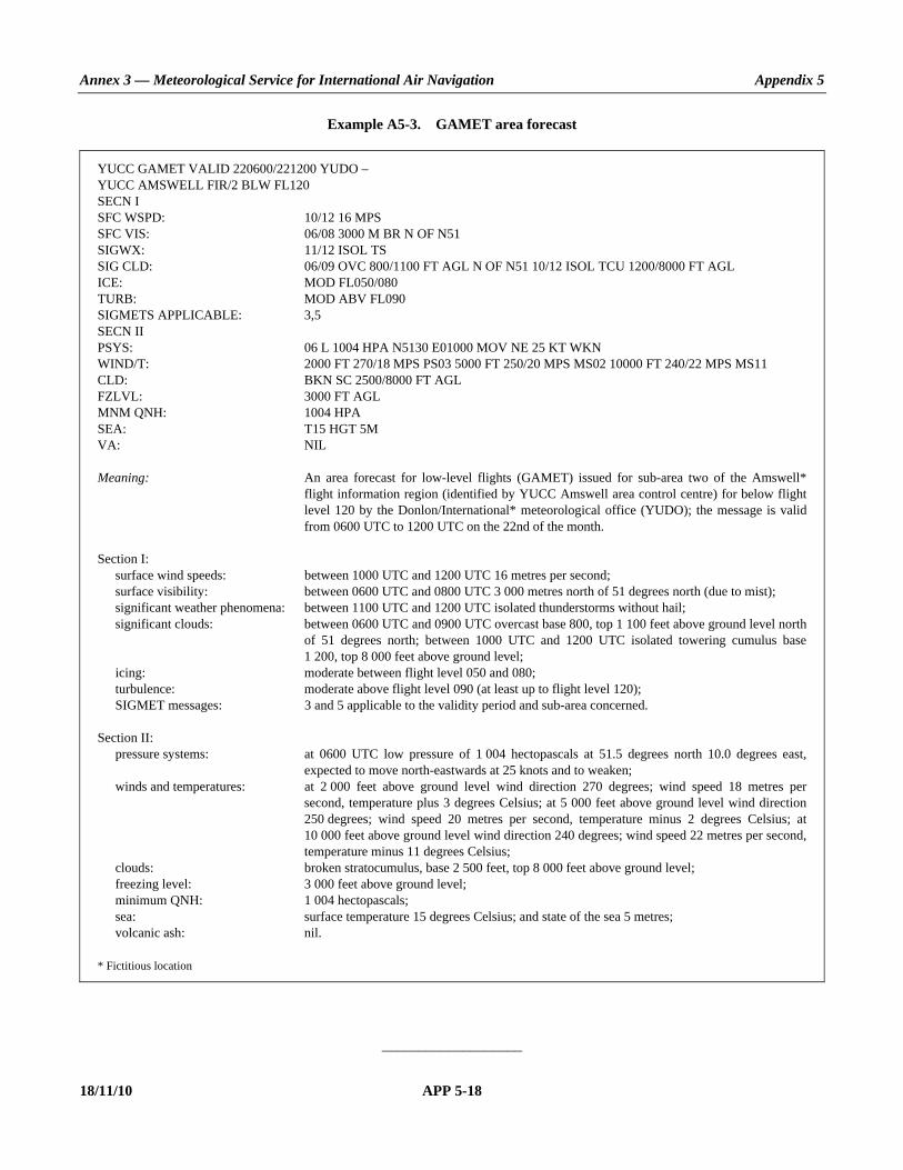
Annex 3 — Meteorological Service for International Air Navigation Appendix 5
18/11/10 APP 5-18
Example A5-3. GAMET area forecast
YUCC GAMET VALID 220600/221200 YUDO – YUCC AMSWELL FIR/2 BLW FL120 SECN I SFC WSPD: 10/12 16 MPS SFC VIS: 06/08 3000 M BR N OF N51 SIGWX: 11/12 ISOL TS SIG CLD: 06/09 OVC 800/1100 FT AGL N OF N51 10/12 ISOL TCU 1200/8000 FT AGL ICE: MOD FL050/080 TURB: MOD ABV FL090 SIGMETS APPLICABLE: 3,5 SECN II PSYS: 06 L 1004 HPA N5130 E01000 MOV NE 25 KT WKN WIND/T: 2000 FT 270/18 MPS PS03 5000 FT 250/20 MPS MS02 10000 FT 240/22 MPS MS11 CLD: BKN SC 2500/8000 FT AGL FZLVL: 3000 FT AGL MNM QNH: 1004 HPA SEA: T15 HGT 5M VA: NIL Meaning: An area forecast for low-level flights (GAMET) issued for sub-area two of the Amswell*
flight information region (identified by YUCC Amswell area control centre) for below flight level 120 by the Donlon/International* meteorological office (YUDO); the message is valid from 0600 UTC to 1200 UTC on the 22nd of the month.
Section I: surface wind speeds: between 1000 UTC and 1200 UTC 16 metres per second; surface visibility: between 0600 UTC and 0800 UTC 3 000 metres north of 51 degrees north (due to mist); significant weather phenomena: between 1100 UTC and 1200 UTC isolated thunderstorms without hail; significant clouds: between 0600 UTC and 0900 UTC overcast base 800, top 1 100 feet above ground level north
of 51 degrees north; between 1000 UTC and 1200 UTC isolated towering cumulus base 1 200, top 8 000 feet above ground level;
icing: moderate between flight level 050 and 080; turbulence: moderate above flight level 090 (at least up to flight level 120); SIGMET messages: 3 and 5 applicable to the validity period and sub-area concerned. Section II: pressure systems: at 0600 UTC low pressure of 1 004 hectopascals at 51.5 degrees north 10.0 degrees east,
expected to move north-eastwards at 25 knots and to weaken; winds and temperatures: at 2 000 feet above ground level wind direction 270 degrees; wind speed 18 metres per
second, temperature plus 3 degrees Celsius; at 5 000 feet above ground level wind direction 250 degrees; wind speed 20 metres per second, temperature minus 2 degrees Celsius; at 10 000 feet above ground level wind direction 240 degrees; wind speed 22 metres per second, temperature minus 11 degrees Celsius;
clouds: broken stratocumulus, base 2 500 feet, top 8 000 feet above ground level; freezing level: 3 000 feet above ground level; minimum QNH: 1 004 hectopascals; sea: surface temperature 15 degrees Celsius; and state of the sea 5 metres; volcanic ash: nil. * Fictitious location
___________________

ANNEX 3 APP 6-1 18/11/10
APPENDIX 6. TECHNICAL SPECIFICATIONS RELATED TO SIGMET AND AIRMET INFORMATION, AERODROME WARNINGS
AND WIND SHEAR WARNINGS AND ALERTS (See Chapter 7 of this Annex.)
Note.— Data type designators to be used in abbreviated headings for SIGMET, AIRMET, tropical cyclone and volcanic ash advisory messages are given in WMO Publication No. 386, Manual on the Global Telecommunication System.
1. SPECIFICATIONS RELATED TO SIGMET INFORMATION
1.1 Format of SIGMET messages 1.1.1 The content and order of elements in a SIGMET message shall be in accordance with the template shown in Table A6-1. 1.1.2 Messages containing SIGMET information shall be identified as: “SIGMET”. 1.1.3 The sequence number referred to in the template in Table A6-1 shall correspond with the number of SIGMET messages issued for the flight information region since 0001 UTC on the day concerned. The meteorological watch offices whose area of responsibility encompasses more than one FIR and/or CTA shall issue separate SIGMET messages for each FIR and/or CTA within their area of responsibility. 1.1.4 In accordance with the template in Table A6-1, only one of the following phenomena shall be included in a SIGMET message, using the abbreviations as indicated below: At cruising levels (irrespective of altitude): thunderstorm — obscured OBSC TS — embedded EMBD TS — frequent FRQ TS — squall line SQL TS — obscured with hail OBSC TSGR — embedded with hail EMBD TSGR — frequent, with hail FRQ TSGR — squall line with hail SQL TSGR tropical cyclone — tropical cyclone with 10-minute mean TC (+ cyclone name) surface wind speed of 17 m/s (34 kt) or more turbulence — severe turbulence SEV TURB

Annex 3 — Meteorological Service for International Air Navigation Appendix 6
18/11/10 APP 6-2
icing — severe icing SEV ICE — severe icing due to SEV ICE (FZRA) freezing rain mountain wave — severe mountain wave SEV MTW duststorm — heavy duststorm HVY DS sandstorm — heavy sandstorm HVY SS volcanic ash — volcanic ash VA (+ volcano name, if known) radioactive cloud RDOACT CLD 1.1.5 SIGMET information shall not contain unnecessary descriptive material. In describing the weather phenomena for which the SIGMET is issued, no descriptive material additional to that given in 1.1.4 shall be included. SIGMET information concerning thunderstorms or a tropical cyclone shall not include references to associated turbulence and icing. 1.1.6 Recommendation.— Meteorological watch offices in a position to do so should issue SIGMET information in graphical format using the WMO BUFR code form, in addition to the issuance of this SIGMET information in abbreviated plain language in accordance with 1.1.1. Note.— The BUFR code form is contained in WMO Publication No. 306, Manual on Codes, Volume I.2, Part B — Binary Codes. 1.1.7 Recommendation.—SIGMET, when issued in graphical format, should be as specified in Appendix 1.
1.2 Dissemination of SIGMET messages 1.2.1 SIGMET messages shall be disseminated to meteorological watch offices, WAFCs and to other meteorological offices in accordance with regional air navigation agreement. SIGMET messages for volcanic ash shall also be disseminated to VAACs. 1.2.2 SIGMET messages shall be disseminated to international OPMET databanks and the centres designated by regional air navigation agreement for the operation of aeronautical fixed service satellite distribution systems, in accordance with regional air navigation agreement.
2. SPECIFICATIONS RELATED TO AIRMET INFORMATION
2.1 Format of AIRMET messages 2.1.1 The content and order of elements in an AIRMET message shall be in accordance with the template shown in Table A6-1.
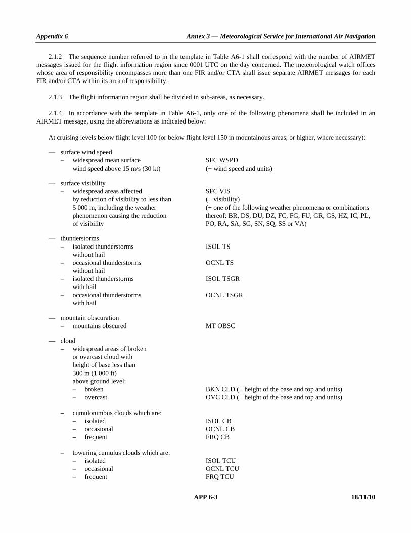
Appendix 6 Annex 3 — Meteorological Service for International Air Navigation
APP 6-3 18/11/10
2.1.2 The sequence number referred to in the template in Table A6-1 shall correspond with the number of AIRMET messages issued for the flight information region since 0001 UTC on the day concerned. The meteorological watch offices whose area of responsibility encompasses more than one FIR and/or CTA shall issue separate AIRMET messages for each FIR and/or CTA within its area of responsibility. 2.1.3 The flight information region shall be divided in sub-areas, as necessary. 2.1.4 In accordance with the template in Table A6-1, only one of the following phenomena shall be included in an AIRMET message, using the abbreviations as indicated below: At cruising levels below flight level 100 (or below flight level 150 in mountainous areas, or higher, where necessary): — surface wind speed – widespread mean surface SFC WSPD wind speed above 15 m/s (30 kt) (+ wind speed and units) — surface visibility – widespread areas affected SFC VIS by reduction of visibility to less than (+ visibility) 5 000 m, including the weather (+ one of the following weather phenomena or combinations phenomenon causing the reduction thereof: BR, DS, DU, DZ, FC, FG, FU, GR, GS, HZ, IC, PL, of visibility PO, RA, SA, SG, SN, SQ, SS or VA) — thunderstorms – isolated thunderstorms ISOL TS without hail – occasional thunderstorms OCNL TS without hail – isolated thunderstorms ISOL TSGR with hail – occasional thunderstorms OCNL TSGR with hail — mountain obscuration – mountains obscured MT OBSC — cloud – widespread areas of broken or overcast cloud with height of base less than 300 m (1 000 ft) above ground level: – broken BKN CLD (+ height of the base and top and units) – overcast OVC CLD (+ height of the base and top and units) – cumulonimbus clouds which are: – isolated ISOL CB – occasional OCNL CB – frequent FRQ CB – towering cumulus clouds which are: – isolated ISOL TCU – occasional OCNL TCU – frequent FRQ TCU
Annex 3 — Meteorological Service for International Air Navigation Appendix 6
18/11/10 APP 6-4
— icing – moderate icing (except for icing MOD ICE in convective clouds) — turbulence – moderate turbulence (except for MOD TURB turbulence in convective clouds) — mountain wave – moderate mountain wave MOD MTW 2.1.5 AIRMET information shall not contain unnecessary descriptive material. In describing the weather phenomena for which the AIRMET is issued, no descriptive material additional to that given in 2.1.4 shall be included. AIRMET information concerning thunderstorms or cumulonimbus clouds shall not include references to associated turbulence and icing. Note.— The specifications for SIGMET information which is also applicable to low-level flights are given in 1.1.4.
2.2 Dissemination of AIRMET messages 2.2.1 Recommendation.— AIRMET messages should be disseminated to meteorological watch offices in adjacent flight information regions and to other meteorological offices, as agreed by the meteorological authorities concerned. 2.2.2 Recommendation.— AIRMET messages should be transmitted to international operational meteorological databanks and the centres designated by regional air navigation agreement for the operation of aeronautical fixed service satellite distribution systems, in accordance with regional air navigation agreement.
3. SPECIFICATIONS RELATED TO SPECIAL AIR-REPORTS Note.— This appendix deals with the uplink of special air-reports. The general specifications related to special air- reports are in Appendix 4. 3.1 Recommendation.— Special air-reports should be uplinked for 60 minutes after their issuance. 3.2 Recommendation.— Information on wind and temperature included in automated special air-reports should not be uplinked to other aircraft in flight.
4. DETAILED CRITERIA RELATED TO SIGMET AND AIRMET MESSAGES AND SPECIAL AIR-REPORTS (UPLINK)
4.1 Identification of the flight information region Recommendation.— In cases where the airspace is divided into a flight information region (FIR) and an upper flight information region (UIR), the SIGMET should be identified by the location indicator of the air traffic services unit serving the FIR. Note.— The SIGMET message applies to the whole airspace within the lateral limits of the FIR, i.e. to the FIR and to the UIR. The particular areas and/or flight levels affected by the meteorological phenomena causing the issuance of the SIGMET are given in the text of the message.

Appendix 6 Annex 3 — Meteorological Service for International Air Navigation
APP 6-5 18/11/10
4.2 Criteria related to phenomena included in SIGMET and AIRMET messages and special air-reports (uplink)
4.2.1 Recommendation.— An area of thunderstorms and cumulonimbus clouds should be considered: a) obscured (OBSC) if it is obscured by haze or smoke or cannot be readily seen due to darkness; b) embedded (EMBD) if it is embedded within cloud layers and cannot be readily recognized; c) isolated (ISOL) if it consists of individual features which affect, or are forecast to affect, an area with a maximum
spatial coverage less than 50 per cent of the area concerned (at a fixed time or during the period of validity); and d) occasional (OCNL) if it consists of well-separated features which affect, or are forecast to affect, an area with a
maximum spatial coverage between 50 and 75 per cent of the area concerned (at a fixed time or during the period of validity).
4.2.2 Recommendation.— An area of thunderstorms should be considered frequent (FRQ) if within that area there is little or no separation between adjacent thunderstorms with a maximum spatial coverage greater than 75 per cent of the area affected, or forecast to be affected, by the phenomenon (at a fixed time or during the period of validity). 4.2.3 Recommendation.— Squall line (SQL) should indicate a thunderstorm along a line with little or no space between individual clouds. 4.2.4 Recommendation.— Hail (GR) should be used as a further description of the thunderstorm, as necessary. 4.2.5 Recommendation.— Severe and moderate turbulence (TURB) should refer only to: low-level turbulence associated with strong surface winds; rotor streaming; or turbulence whether in cloud or not in cloud (CAT). Turbulence should not be used in connection with convective clouds. 4.2.6 Turbulence shall be considered: a) severe whenever the peak value of the cube root of EDR exceeds 0.7; and b) moderate whenever the peak value of the cube root of EDR is above 0.4 and below or equal to 0.7. 4.2.7 Recommendation.— Severe and moderate icing (ICE) should refer to icing in other than convective clouds. Freezing rain (FZRA) should refer to severe icing conditions caused by freezing rain. 4.2.8 Recommendation.— A mountain wave (MTW) should be considered: a) severe whenever an accompanying downdraft of 3.0 m/s (600 ft/min) or more and/or severe turbulence is observed
or forecast; and b) moderate whenever an accompanying downdraft of 1.75–3.0 m/s (350–600 ft/min) and/or moderate turbulence is
observed or forecast.
5. SPECIFICATIONS RELATED TO AERODROME WARNINGS
5.1 Format and dissemination of aerodrome warnings 5.1.1 The aerodrome warnings shall be issued in accordance with the template in Table A6-2 where required by operators or aerodrome services, and shall be disseminated in accordance with local arrangements to those concerned.
Annex 3 — Meteorological Service for International Air Navigation Appendix 6
18/11/10 APP 6-6
5.1.2 The sequence number referred to in the template in Table A6-2 shall correspond with the number of aerodrome warnings issued for the aerodrome since 0001 UTC on the day concerned. 5.1.3 Recommendation.— In accordance with the template in Table A6-2, aerodrome warnings should relate to the occurrence or expected occurrence of one or more of the following phenomena: — tropical cyclone (to be included if the 10-minute mean surface wind speed at the aerodrome is expected to be 17 m/s
(34 kt) or more) — thunderstorm — hail — snow (including the expected or observed snow accumulation) — freezing precipitation — hoar frost or rime — sandstorm — duststorm — rising sand or dust — strong surface wind and gusts — squall — frost — volcanic ash — tsunami — volcanic ash deposition — toxic chemicals — other phenomena as agreed locally. 5.1.4 Recommendation.— The use of text additional to the abbreviations listed in the template in Table A6-2 should be kept to a minimum. The additional text should be prepared in abbreviated plain language using approved ICAO abbreviations and numerical values. If no ICAO approved abbreviations are available, English plain language text should be used.
5.2 Quantitative criteria for aerodrome warnings Recommendation.— When quantitative criteria are necessary for the issue of aerodrome warnings covering, for example, the expected maximum wind speed or the expected total snowfall, the criteria should be established by agreement between the meteorological office and the users of the warnings.
6. SPECIFICATIONS RELATED TO WIND SHEAR WARNINGS
6.1 Detection of wind shear Recommendation.— Evidence of the existence of wind shear should be derived from: a) ground-based, wind shear remote-sensing equipment, for example, Doppler radar; b) ground-based, wind shear detection equipment, for example, a system of surface wind and/or pressure sensors
located in an array monitoring a specific runway or runways and associated approach and departure paths; c) aircraft observations during the climb-out or approach phases of flight to be made in accordance with Chapter 5; or

Appendix 6 Annex 3 — Meteorological Service for International Air Navigation
APP 6-7 18/11/10
d) other meteorological information, for example, from appropriate sensors located on existing masts or towers in the vicinity of the aerodrome or nearby areas of high ground.
Note.— Wind shear conditions are normally associated with the following phenomena: — thunderstorms, microbursts, funnel cloud (tornado or waterspout), and gust fronts — frontal surfaces — strong surface winds coupled with local topography — sea breeze fronts — mountain waves (including low-level rotors in the terminal area) — low-level temperature inversions.
6.2 Format and dissemination of wind shear warnings and alerts Note.— Information on wind shear is also to be included as supplementary information in local routine and special reports and METAR and SPECI in accordance with the templates in Appendix 3, Tables A3-1 and A3-2. 6.2.1 The wind shear warnings shall be issued in accordance with the template in Table A6-3 and shall be disseminated in accordance with local arrangements to those concerned. 6.2.2 The sequence number referred to in the template in Table A6-3 shall correspond with the number of wind shear warnings issued for the aerodrome since 0001 UTC on the day concerned. 6.2.3 Recommendation.— The use of text additional to the abbreviations listed in the template in Table A6-3 should be kept to a minimum. The additional text should be prepared in abbreviated plain language using approved ICAO abbreviations and numerical values. If no ICAO approved abbreviations are available, English plain language text should be used. 6.2.4 Recommendation.— When an aircraft report is used to prepare a wind shear warning, or to confirm a warning previously issued, the corresponding aircraft report, including the aircraft type, should be disseminated unchanged in accordance with local arrangements to those concerned. Note 1.— Following reported encounters by both arriving and departing aircraft, two different wind shear warnings may exist: one for arriving aircraft and one for departing aircraft. Note 2.— Specifications for reporting the intensity of wind shear are still undergoing development. It is recognized, however, that pilots, when reporting wind shear, may use the qualifying terms “moderate”, “strong” or “severe”, based to a large extent on their subjective assessment of the intensity of the wind shear encountered. 6.2.5 The wind shear alerts shall be disseminated from automated, ground-based, wind shear remote-sensing or detection equipment in accordance with local arrangements to those concerned. 6.2.6 Recommendation.— Where microbursts are observed, reported by pilots or detected by ground-based, wind shear detection or remote-sensing equipment, the wind shear warning and wind shear alert should include a specific reference to microburst. 6.2.7 Where information from ground-based, wind shear detection or remote-sensing equipment is used to prepare a wind shear alert, the alert shall, if practicable, relate to specific sections of the runway and distances along the approach path or take-off path as agreed between the meteorological authority, the appropriate ATS authority and the operators concerned.
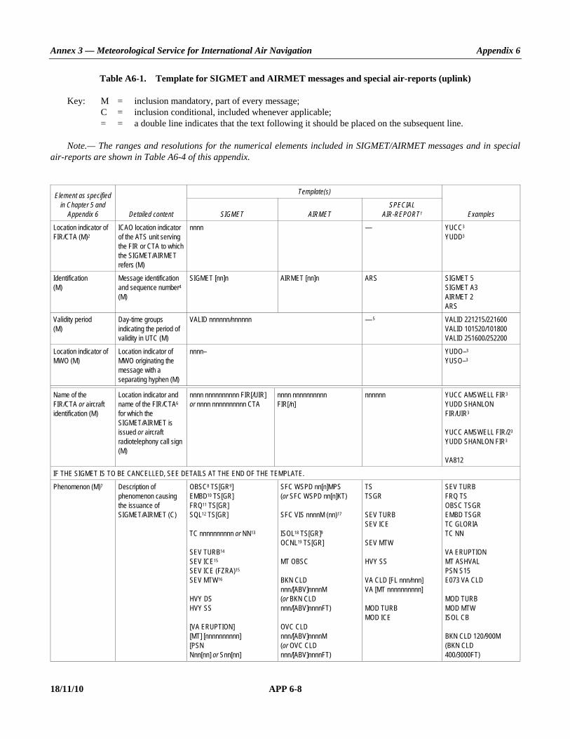
Annex 3 — Meteorological Service for International Air Navigation Appendix 6
18/11/10 APP 6-8
Table A6-1. Template for SIGMET and AIRMET messages and special air-reports (uplink) Key: M = inclusion mandatory, part of every message; C = inclusion conditional, included whenever applicable; = = a double line indicates that the text following it should be placed on the subsequent line. Note.— The ranges and resolutions for the numerical elements included in SIGMET/AIRMET messages and in special air-reports are shown in Table A6-4 of this appendix.
Element as specified in Chapter 5 and
Appendix 6 Detailed content
Template(s)
Examples SIGMET AIRMET SPECIAL
AIR-REPORT1
Location indicator of FIR/CTA (M)2
ICAO location indicator of the ATS unit serving the FIR or CTA to which the SIGMET/AIRMET refers (M)
nnnn — YUCC3 YUDD3
Identification (M)
Message identification and sequence number4 (M)
SIGMET [nn]n AIRMET [nn]n ARS SIGMET 5 SIGMET A3 AIRMET 2 ARS
Validity period (M)
Day-time groups indicating the period of validity in UTC (M)
VALID nnnnnn/nnnnnn — 5 VALID 221215/221600 VALID 101520/101800 VALID 251600/252200
Location indicator of MWO (M)
Location indicator of MWO originating the message with a separating hyphen (M)
nnnn– YUDO–3 YUSO–3
Name of the FIR/CTA or aircraft identification (M)
Location indicator and name of the FIR/CTA6 for which the SIGMET/AIRMET is issued or aircraft radiotelephony call sign (M)
nnnn nnnnnnnnnn FIR[/UIR] or nnnn nnnnnnnnnn CTA
nnnn nnnnnnnnnn FIR[/n]
nnnnnn YUCC AMSWELL FIR3 YUDD SHANLON FIR/UIR3 YUCC AMSWELL FIR/23 YUDD SHANLON FIR3 VA812
IF THE SIGMET IS TO BE CANCELLED, SEE DETAILS AT THE END OF THE TEMPLATE.
Phenomenon (M)7 Description of phenomenon causing the issuance of SIGMET/AIRMET (C)
OBSC8 TS[GR9] EMBD10 TS[GR] FRQ11 TS[GR] SQL12 TS[GR] TC nnnnnnnnnn or NN13 SEV TURB14 SEV ICE15 SEV ICE (FZRA)15 SEV MTW16 HVY DS HVY SS [VA ERUPTION] [MT] [nnnnnnnnnn] [PSN Nnn[nn] or Snn[nn]
SFC WSPD nn[n]MPS (or SFC WSPD nn[n]KT) SFC VIS nnnnM (nn)17 ISOL18 TS[GR]9 OCNL19 TS[GR] MT OBSC BKN CLD nnn/[ABV]nnnnM (or BKN CLD nnn/[ABV]nnnnFT) OVC CLD nnn/[ABV]nnnnM (or OVC CLD nnn/[ABV]nnnnFT)
TS TSGR SEV TURB SEV ICE SEV MTW HVY SS VA CLD [FL nnn/nnn] VA [MT nnnnnnnnnn] MOD TURB MOD ICE
SEV TURB FRQ TS OBSC TSGR EMBD TSGR TC GLORIA TC NN VA ERUPTION MT ASHVAL PSN S15 E073 VA CLD MOD TURB MOD MTW ISOL CB BKN CLD 120/900M (BKN CLD 400/3000FT)

Appendix 6 Annex 3 — Meteorological Service for International Air Navigation
APP 6-9 18/11/10
Element as specified in Chapter 5 and
Appendix 6 Detailed content
Template(s)
Examples SIGMET AIRMET SPECIAL
AIR-REPORT1
Ennn[nn] or Wnnn[nn]] VA CLD RDOACT CLD
ISOL18 CB20 OCNL19 CB FRQ11 CB ISOL18 TCU20 OCNL19 TCU20 FRQ11 TCU MOD TURB14 MOD ICE15 MOD MTW16
OVC CLD 270/ABV3000M (OVC CLD 900/ABV10000FT) SEV ICE RDOACT CLD
Observed or forecast phenomenon (M)
Indication whether the information is observed and expected to continue, or forecast (M)
OBS [AT nnnnZ] FCST [AT nnnnZ]
OBS AT nnnnZ OBS AT 1210Z OBS FCST AT 1815Z
Location (C)21 Location (referring to latitude and longitude (in degrees and minutes) or locations or geographic features well known internationally)
Nnn[nn] Wnnn[nn] or Nnn[nn] Ennn[nn] or Snn[nn] Wnnn[nn] or Snn[nn] Ennn[nn] or N OF Nnn[nn] or S OF Nnn[nn] or N OF Snn[nn] or S OF Snn[nn] or [AND] W OF Wnnn[nn] or E OF Wnnn[nn] or W OF Ennn[nn] or E OF Ennn[nn] or [N OF, NE OF, E OF, SE OF, S OF, SW OF, W OF, NW OF] [LINE] Nnn[nn] or Snn[nn] Wnnn[nn] or Ennn[nn] – Nnn[nn] or Snn[nn] Wnnn[nn] or Ennn[nn] or [N OF, NE OF, E OF, SE OF, S OF, SW OF, W OF, NW OF, AT] nnnnnnnnnnnn or WI Nnn[nn] or Snn[nn] Wnnn[nn] or Ennn[nn] – Nnn[nn] or Snn[nn] Wnnn[nn] or Ennn[nn] – Nnn[nn] or Snn[nn] Wnnn[nn] or Ennn[nn] – [Nnn[nn] or Snn[nn] Wnnn[nn] or Ennn[nn] – Nnn[nn] or Snn[nn] Wnnn[nn] or Ennn[nn]]
NnnnnWnnnnn or NnnnnEnnnnn or SnnnnWnnnnn or SnnnnEnnnnn
S OF N54 N OF N50 N2020 W07005 AT YUSB3 N2706 W07306 N48 E010 N OF N1515 AND W OF E13530 W OF E1554 N OF LINE S2520 W11510 – S2520 W12010 WI N6030 E02550 – N6055 E02500 – N6050 E02630
Level (C)21 Flight level or altitude and extent (C)22
[SFC/]FLnnn or [SFC/]nnnnM (or [SFC/]nnnnFT) or FLnnn/nnn or TOP FLnnn or [TOP] ABV FLnnn or 23 CB TOP [ABV] FLnnn WI nnnKM OF CENTRE (or CB TOP [ABV] FLnnn WI nnnNM OF CENTRE) or CB TOP [BLW] FLnnn WI nnnKM OF CENTRE (or CB TOP [BLW] FLnnn WI nnnNM OF CENTRE) or 24 FLnnn/nnn [APRX nnnKM BY nnnKM] [nnKM WID LINE25 BTN (nnNM WID LINE BTN)] [Nnn[nn] or Snn[nn] Wnnn[nn] or Ennn[nn]
FLnnn or nnnnM (or nnnnFT)
FL180 FL050/080 TOP FL390 SFC/FL070 TOP ABV FL100 FL310/450 CB TOP FL500 WI 270KM OF CENTRE (CB TOP FL500 WI 150NM OF CENTRE) FL310/350 APRX 220KM BY 35KM

Annex 3 — Meteorological Service for International Air Navigation Appendix 6
18/11/10 APP 6-10
Element as specified in Chapter 5 and
Appendix 6 Detailed content
Template(s)
Examples SIGMET AIRMET SPECIAL
AIR-REPORT1
– Nnn[nn] or Snn[nn] Wnnn[nn] or Ennn[nn] [ – Nnn[nn] or Snn[nn] Wnnn[nn] or Ennn[nn]] [ – Nnn[nn] or Snn[nn] Wnnn[nn] or Ennn[nn]]] (or FLnnn/nnn [APRX nnnNM BY nnnNM] [Nnn[nn] or Snn[nn] Wnnn[nn] or Ennn[nn] – Nnn[nn] or Snn[nn] Wnnn[nn] or Ennn[nn] [ – Nnn[nn] or Snn[nn] Wnnn[nn] or Ennn[nn]] [ – Nnn[nn] or Snn[nn] Wnnn[nn] or Ennn[nn]]])
FL390
Movement or expected movement (C)21
Movement or expected movement (direction and speed) with reference to one of the sixteen points of compass, or stationary (C)
MOV N [nnKMH] or MOV NNE [nnKMH] or MOV NE [nnKMH] or MOV ENE [nnKMH] or MOV E [nnKMH] or MOV ESE [nnKMH] or MOV SE [nnKMH] or MOV SSE [nnKMH] or MOV S [nnKMH] or MOV SSW [nnKMH] or MOV SW [nnKMH] or MOV WSW [nnKMH] or MOV W [nnKMH] or MOV WNW [nnKMH] or MOV NW [nnKMH] or MOV NNW [nnKMH] (or MOV N [nnKT] or MOV NNE [nnKT] or MOV NE [nnKT] or MOV ENE [nnKT] or MOV E [nnKT] or MOV ESE [nnKT] or MOV SE [nnKT] or MOV SSE [nnKT] or MOV S [nnKT] or MOV SSW [nnKT] or MOV SW [nnKT] or MOV WSW [nnKT] or MOV W [nnKT] or MOV WNW [nnKT] or MOV NW [nnKT] or MOV NNW [nnKT]) or STNR
— MOV E 40KMH (MOV E 20KT) MOV SE STNR
Changes in intensity (C)21
Expected changes in intensity (C)
INTSF or WKN or NC — WKN
Forecast position (C)21, 22
Forecast position of volcanic ash cloud or the centre of the TC at the end of the validity period of the SIGMET message (C)
FCST nnnnZ TC CENTRE Nnn[nn] or Snn[nn] Wnnn[nn] or Ennn[nn] or FCST nnnnZ VA CLD APRX [nnKM WID LINE25 BTN (nnNM WID LINE BTN)] Nnn[nn] or Snn[nn] Wnnn[nn] or Ennn[nn] – Nnn[nn] or Snn[nn] Wnnn[nn] or Ennn[nn] [ – Nnn[nn] or Snn[nn] Wnnn[nn] or Ennn[nn]] [ – Nnn[nn] or Snn[nn] Wnnn[nn] or Ennn[nn]] [AND]26
— — FCST 2200Z TC CENTRE N2740 W07345 FCST 1700Z VA CLD APRX S15 E075 – S15 E081 – S17 E083 – S18 E079 – S15 E075
OR
Cancellation of SIGMET/ AIRMET (C)27
Cancellation of SIGMET/AIRMET referring to its identification
CNL SIGMET [nn]n nnnnnn/nnnnnn or CNL SIGMET [nn]n nnnnnn/nnnnnn [VA MOV TO nnnn FIR]24
CNL AIRMET [nn]n nnnnnn/nnnnnn
— CNL SIGMET 2 101200/10160027 CNL SIGMET 3 251030/251430 VA MOV TO YUDO FIR27 CNL AIRMET 151520/15180027

Appendix 6 Annex 3 — Meteorological Service for International Air Navigation
APP 6-11 18/11/10
Notes.— 1. No wind and temperature to be uplinked to other aircraft in flight in accordance with 3.2. 2. See 4.1. 3. Fictitious location. 4. In accordance with 1.1.3 and 2.1.2. 5. See 3.1. 6. See 2.1.3. 7. In accordance with 1.1.4 and 2.1.4. 8. In accordance with 4.2.1 a). 9. In accordance with 4.2.4. 10. In accordance with 4.2.1 b). 11. In accordance with 4.2.2. 12. In accordance with 4.2.3. 13. Used for unnamed tropical cyclones. 14. In accordance with 4.2.5 and 4.2.6. 15. In accordance with 4.2.7. 16. In accordance with 4.2.8. 17. In accordance with 2.1.4. 18. In accordance with 4.2.1 c). 19 In accordance with 4.2.1 d). 20. The use of cumulonimbus, CB, and towering cumulus, TCU, is restricted to AIRMETs in accordance with 2.1.4. 21. In the case of the same phenomenon covering more than one area within the FIR, these elements can be repeated, as necessary. 22. Only for SIGMET messages for volcanic ash cloud and tropical cyclones. 23. Only for SIGMET messages for tropical cyclones. 24. Only for SIGMET messages for volcanic ash. 25. A straight line between two points drawn on a map in the Mercator projection or a straight line between two points which crosses lines of longitude at a constant angle. 26. To be used for two volcanic ash clouds or two centres of tropical cyclones simultaneously affecting the FIR concerned.. 27. End of the message (as the SIGMET/AIRMET message is being cancelled). Note.— In accordance with 1.1.5 and 2.1.5, severe or moderate icing and severe or moderate turbulence (SEV ICE, MOD ICE, SEV TURB, MOD TURB) associated with thunderstorms, cumulonimbus clouds or tropical cyclones should not be included.

Annex 3 — Meteorological Service for International Air Navigation Appendix 6
18/11/10 APP 6-12
Table A6-2. Template for aerodrome warnings Key: M = inclusion mandatory, part of every message; C = inclusion conditional, included whenever applicable. Note 1.— The ranges and resolutions for the numerical elements included in aerodrome warnings are shown in Table A6-4 of this appendix. Note 2.— The explanations for the abbreviations can be found in the Procedures for Air Navigation Services — ICAO Abbreviations and Codes (PANS-ABC, Doc 8400).
Element Detailed content Templates Examples Location indicator of the aerodrome (M)
Location indicator of the aerodrome nnnn YUCC1
Identification of the type of message (M)
Type of message and sequence number AD WRNG [n]n AD WRNG 2
Validity period (M) Day and time of validity period in UTC VALID nnnnnn/nnnnnn VALID 211230/211530 IF THE AERODROME WARNING IS TO BE CANCELLED, SEE DETAILS AT THE END OF THE TEMPLATE. Phenomenon (M)2 Description of phenomenon causing the
issuance of the aerodrome warning TC3 nnnnnnnnnn or [HVY] TS or GR or [HVY] SN [nnCM]3 or [HVY] FZRA or [HVY] FZDZ or RIME4 or [HVY] SS or [HVY] DS or SA or DU or SFC WSPD nn[n]MPS MAX nn[n] (SFC WSPD nn[n]KT MAX nn[n]) or SFC WIND nnn/nn[n]MPS MAX nn[n] (SFC WIND nnn/nn[n]KT MAX nn[n]) or SQ or FROST or TSUNAMI or VA[DEPO] or TOX CHEM or Free text up to 32 characters5
TC ANDREW HVY SN 25CM SFC WSPD 20MPS MAX 30 VA TSUNAMI
Observed or forecast phenomenon (M)
Indication whether the information is observed and expected to continue, or forecast
OBS [AT nnnnZ] or FCST
OBS AT 1200Z OBS
Changes in intensity (C) Expected changes in intensity INTSF or WKN or NC
WKN
OR Cancellation of aerodrome warning6
Cancellation of aerodrome warning referring to its identification
CNL AD WRNG [n]n nnnnnn/nnnnnn CNL AD WRNG 2 211230/2115306
Notes.— 1. Fictitious location. 2. One phenomenon or a combination thereof, in accordance with 5.1.3. 3. In accordance with 5.1.3. 4. Hoar frost or rime in accordance with 5.1.3. 5. In accordance with 5.1.4. 6. End of the message (as the aerodrome warning is being cancelled).

Appendix 6 Annex 3 — Meteorological Service for International Air Navigation
APP 6-13 18/11/10
Table A6-3. Template for wind shear warnings Key: M = inclusion mandatory, part of every message; C = inclusion conditional, included whenever applicable. Note 1.— The ranges and resolutions for the numerical elements included in wind shear warnings are shown in Table A6-4 of this appendix. Note 2.— The explanations for the abbreviations can be found in the Procedures for Air Navigation Services — ICAO Abbreviations and Codes (PANS-ABC, Doc 8400).
Element Detailed content Template(s) Example
Location indicator of the aerodrome (M)
Location indicator of the aerodrome nnnn YUCC1
Identification of the type of message (M)
Type of message and sequence number
WS WRNG [n]n WS WRNG 1
Time of origin and validity period (M) Day and time of issue and, where applicable, validity period in UTC
nnnnnn [VALID TL nnnnnn] or [VALID nnnnnn/nnnnnn]
211230 VALID TL 211330 221200 VALID 221215/221315
IF THE WIND SHEAR WARNING IS TO BE CANCELLED, SEE DETAILS AT THE END OF THE TEMPLATE.
Phenomenon (M) Identification of the phenomenon and its location
[MOD] or [SEV] WS IN APCH or [MOD] or [SEV] WS [APCH] RWYnnn or [MOD] or [SEV] WS IN CLIMB-OUT or [MOD] or [SEV] WS CLIMB-OUT RWYnnn or MBST IN APCH or MBST [APCH] RWYnnn or MBST IN CLIMB-OUT or MBST CLIMB-OUT RWYnnn
WS APCH RWY12 MOD WS RWY34 WS IN CLIMB-OUT MBST APCH RWY26 MBST IN CLIMB-OUT
Observed, reported or forecast phenomenon (M)
Identification whether the phenomenon is observed or reported and expected to continue or forecast
REP AT nnnn nnnnnnnn or OBS [AT nnnn] or FCST
REP AT 1510 B747 OBS AT 1205 FCST
Details of the phenomenon (C)2 Description of phenomenon causing the issuance of the wind shear warning
SFC WIND: nnn/nnMPS (or nnn/nnKT) nnnM (nnnFT)-WIND: nnn/nnMPS (or nnn/nnKT) or nnKMH (or nnKT) LOSS nnKM (or nnNM) FNA RWYnn or nnKMH (or nnKT) GAIN nnKM (or nnNM) FNA RWYnn
SFC WIND: 320/5MPS 60M-WIND: 360/13MPS (SFC WIND: 320/10KT 200FT-WIND: 360/26KT) 60KMH LOSS 4KM FNA RWY13 (30KT LOSS 2NM FNA RWY13)
OR
Cancellation of wind shear warning3 Cancellation of wind shear warning referring to its identification
CNL WS WRNG [n]n nnnnnn/nnnnnn CNL WS WRNG 1 211230/2113303
Notes.— 1. Fictitious location. 2. Additional provisions in 6.2.3. 3. End of the message (as the wind shear warning is being cancelled).

Annex 3 — Meteorological Service for International Air Navigation Appendix 6
18/11/10 APP 6-14
Table A6-4. Ranges and resolutions for the numerical elements included in volcanic ash and tropical cyclone advisory messages,
SIGMET/AIRMET messages and aerodrome and wind shear warnings
Element as specified in Appendices 2 and 6 Range Resolution
Summit elevation: M FT
000 – 8 100 000 – 27 000
1 1
Advisory number: for VA (index)* for TC (index)*
000 – 2 000 00 – 99
1 1
Maximum surface wind: MPS KT
00 – 99 00 – 199
1 1
Central pressure: hPa 850 – 1 050 1
Surface wind speed: MPS KT
15 – 49 30 – 99
1 1
Surface visibility: M M
0000 – 0750 0800 – 5 000
50 100
Cloud: height of base: M FT
000 – 300 000 – 1 000
30 100
Cloud: height of top: M M
FT FT
000 – 2 970 3 000 – 20 000
000 – 9 900 10 000 – 60 000
30 300 100
1 000
Latitudes: ° (degrees) ΄ (minutes)
00 – 90 00 – 60
1 1
Longitudes: ° (degrees) ΄ (minutes)
000 – 180 00 – 60
1 1
Flight levels: 000 – 650 10
Movement: KMH KT
0 – 300 0 – 150
10 5
* Non-dimensional
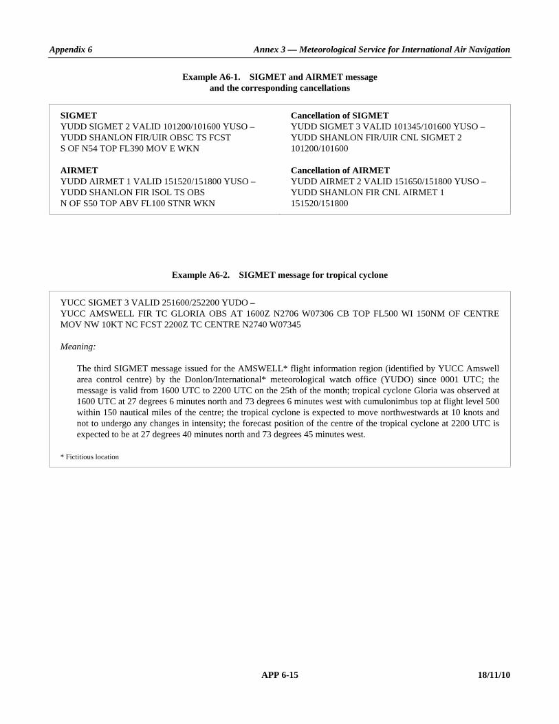
Appendix 6 Annex 3 — Meteorological Service for International Air Navigation
APP 6-15 18/11/10
Example A6-1. SIGMET and AIRMET message and the corresponding cancellations
SIGMET Cancellation of SIGMET YUDD SIGMET 2 VALID 101200/101600 YUSO – YUDD SHANLON FIR/UIR OBSC TS FCST S OF N54 TOP FL390 MOV E WKN
YUDD SIGMET 3 VALID 101345/101600 YUSO – YUDD SHANLON FIR/UIR CNL SIGMET 2 101200/101600
AIRMET Cancellation of AIRMET YUDD AIRMET 1 VALID 151520/151800 YUSO – YUDD SHANLON FIR ISOL TS OBS N OF S50 TOP ABV FL100 STNR WKN
YUDD AIRMET 2 VALID 151650/151800 YUSO – YUDD SHANLON FIR CNL AIRMET 1 151520/151800
Example A6-2. SIGMET message for tropical cyclone
YUCC SIGMET 3 VALID 251600/252200 YUDO – YUCC AMSWELL FIR TC GLORIA OBS AT 1600Z N2706 W07306 CB TOP FL500 WI 150NM OF CENTRE MOV NW 10KT NC FCST 2200Z TC CENTRE N2740 W07345 Meaning: The third SIGMET message issued for the AMSWELL* flight information region (identified by YUCC Amswell
area control centre) by the Donlon/International* meteorological watch office (YUDO) since 0001 UTC; the message is valid from 1600 UTC to 2200 UTC on the 25th of the month; tropical cyclone Gloria was observed at 1600 UTC at 27 degrees 6 minutes north and 73 degrees 6 minutes west with cumulonimbus top at flight level 500 within 150 nautical miles of the centre; the tropical cyclone is expected to move northwestwards at 10 knots and not to undergo any changes in intensity; the forecast position of the centre of the tropical cyclone at 2200 UTC is expected to be at 27 degrees 40 minutes north and 73 degrees 45 minutes west.
* Fictitious location

Annex 3 — Meteorological Service for International Air Navigation Appendix 6
18/11/10 APP 6-16
Example A6-3. SIGMET message for volcanic ash
YUDD SIGMET 2 VALID 211100/211700 YUSO – YUDD SHANLON FIR/UIR VA ERUPTION MT ASHVAL PSN S1500 E07348 VA CLD OBS AT 1100Z FL310/450 APRX 220KM BY 35KM S1500 E07348 – S1530 E07642 MOV SE 65KMH FCST 1700Z VA CLD APRX S1506 E07500 – S1518 E08112 – S1712 E08330 – S1824 E07836 Meaning:
The second SIGMET message issued for the SHANLON* flight information region (identified by YUDD Shanlon area control centre/upper flight information region) by the Shanlon/International* meteorological watch office (YUSO) since 0001 UTC; the message is valid from 1100 UTC to 1700 UTC on the 21st of the month; volcanic ash eruption of Mount Ashval* located at 15 degrees south and 73 degrees 48 minutes east; volcanic ash cloud observed at 1100 UTC between flight levels 310 and 450 in an approximate area of 220 km by 35 km between 15 degrees south and 73 degrees 48 minutes east, and 15 degrees 30 minutes south and 76 degrees 42 minutes east; the volcanic ash cloud is expected to move southeastwards at 65 kilometres per hour; at 1700 UTC the volcanic ash cloud is forecast to be located approximately in an area bounded by the following points: 15 degrees 6 minutes south and 75 degrees east, 15 degrees 18 minutes south and 81 degrees 12 minutes east, 17 degrees 12 minutes south and 83 degrees 30 minutes east, and 18 degrees 24 minutes south and 78 degrees 36 minutes east.
* Fictitious location
Example A6-4. SIGMET message for severe turbulence
YUCC SIGMET 5 VALID 221215/221600 YUDO – YUCC AMSWELL FIR SEV TURB OBS AT 1210Z AT YUSB FL250 MOV E 40KMH WKN Meaning:
The fifth SIGMET message issued for the AMSWELL* flight information region (identified by YUCC Amswell area control centre) by the Donlon/International* meteorological watch office (YUDO) since 0001 UTC; the message is valid from 1215 UTC to 1600 UTC on the 22nd of the month; severe turbulence was observed at 1210 UTC over Siby/Bistock* aerodrome (YUSB) at flight level 250; the turbulence is expected to move eastwards at 40 kilometres per hour and to weaken in intensity.
* Fictitious location

Appendix 6 Annex 3 — Meteorological Service for International Air Navigation
APP 6-17 18/11/10
Example A6-5. AIRMET message for moderate mountain wave
YUCC AIRMET 2 VALID 221215/221600 YUDO – YUCC AMSWELL FIR MOD MTW OBS AT 1205Z N48 E010 FL080 STNR NC Meaning:
The second AIRMET message issued for the AMSWELL* flight information region (identified by YUCC Amswell area control centre) by the Donlon/International* meteorological watch office (YUDO) since 0001 UTC; the message is valid from 1215 UTC to 1600 UTC on the 22nd of the month; moderate mountain wave was observed at 1205 UTC at 48 degrees north and 10 degrees east at flight level 080; the mountain wave is expected to remain stationary and not to undergo any changes in intensity.
* Fictitious location
___________________


ANNEX 3 APP 7-1 18/11/10
APPENDIX 7. TECHNICAL SPECIFICATIONS RELATED TO AERONAUTICAL CLIMATOLOGICAL INFORMATION
(See Chapter 8 of this Annex.)
1. PROCESSING OF AERONAUTICAL CLIMATOLOGICAL INFORMATION Recommendation.— Meteorological observations for regular and alternate aerodromes should be collected, processed and stored in a form suitable for the preparation of aerodrome climatological information.
2. EXCHANGE OF AERONAUTICAL CLIMATOLOGICAL INFORMATION Recommendation.— Aeronautical climatological information should be exchanged on request between meteorological authorities. Operators and other aeronautical users desiring such information should normally apply to the meteorological authority responsible for its preparation.
3. CONTENT OF AERONAUTICAL CLIMATOLOGICAL INFORMATION
3.1 Aerodrome climatological tables 3.1.1 Recommendation.— An aerodrome climatological table should give as applicable: a) mean values and variations therefrom, including maximum and minimum values, of meteorological elements (for
example, of air temperature); and/or b) the frequency of occurrence of present weather phenomena affecting flight operations at the aerodrome (for
example, of sandstorms); and/or c) the frequency of occurrence of specified values of one, or of a combination of two or more, elements (for example, of
a combination of low visibility and low cloud). 3.1.2 Recommendation.— Aerodrome climatological tables should include information required for the preparation of aerodrome climatological summaries in accordance with 3.2.
3.2 Aerodrome climatological summaries Recommendation.— Aerodrome climatological summaries should cover: a) frequencies of the occurrence of runway visual range/visibility and/or height of the base of the lowest cloud layer of
BKN or OVC extent below specified values at specified times; b) frequencies of visibility below specified values at specified times;

Annex 3 — Meteorological Service for International Air Navigation Appendix 7
18/11/10 APP 7-2
c) frequencies of the height of the base of the lowest cloud layer of BKN or OVC extent below specified values at specified times;
d) frequencies of occurrence of concurrent wind direction and speed within specified ranges; e) frequencies of surface temperature in specified ranges of 5°C at specified times; and f) mean values and variations therefrom, including maximum and minimum values of meteorological elements
required for operational planning purposes, including take-off performance calculations. Note.— Models of climatological summaries related to a) to e) are given in WMO Publication No. 49, Technical Regulations, Volume II, C.3.2.
___________________
ANNEX 3 APP 8-1 18/11/10
APPENDIX 8. TECHNICAL SPECIFICATIONS RELATED TO SERVICE FOR OPERATORS AND FLIGHT CREW MEMBERS
(See Chapter 9 of this Annex.)
Note.— Specifications related to flight documentation (including the model charts and forms) are given in Appendix 1.
1. MEANS OF SUPPLY AND FORMAT OF METEOROLOGICAL INFORMATION 1.1 Meteorological information shall be supplied to operators and flight crew members by one or more of the following, as agreed between the meteorological authority and operator concerned, and with the order shown below not implying priorities: a) written or printed material, including specified charts and forms; b) data in digital form; c) briefing; d) consultation; e) display; or f) in lieu of a) to e), by means of an automated pre-flight information system providing self-briefing and flight
documentation facilities while retaining access by operators and aircrew members to consultation, as necessary, with the meteorological office, in accordance with 5.1.
1.2 The meteorological authority, in consultation with the operator, shall determine: a) the type and format of meteorological information to be supplied; and b) methods and means of supplying that information. 1.3 Recommendation.— On request by the operator, the meteorological information supplied for flight planning should include data for the determination of the lowest usable flight level.
2. SPECIFICATIONS RELATED TO INFORMATION FOR PRE-FLIGHT PLANNING AND IN-FLIGHT RE-PLANNING
2.1 Format of upper-air gridded information Upper-air gridded information supplied by WAFCs for pre-flight and in-flight re-planning shall be in the GRIB code form. Note.— The GRIB code form is contained in WMO Publication No. 306, Manual on Codes, Volume I.2, Part B — Binary Codes.

Annex 3 — Meteorological Service for International Air Navigation Appendix 8
18/11/10 APP 8-2
2.2 Format of information on significant weather Information on significant weather supplied by WAFCs for pre-flight and in-flight re-planning shall be in the BUFR code form. Note.— The BUFR code form is contained in WMO Publication No. 306, Manual on Codes, Volume I.2, Part B — Binary Codes.
2.3 Specific needs of helicopter operations Recommendation.— Meteorological information for pre-flight planning and in-flight re-planning by operators of helicopters flying to offshore structures should include data covering the layers from sea level to flight level 100. Particular mention should be made of the expected surface visibility, the amount, type (where available), base and tops of cloud below flight level 100, sea state and sea-surface temperature, mean sea-level pressure, and the occurrence and expected occurrence of turbulence and icing, as determined by regional air navigation agreement.
3. SPECIFICATIONS RELATED TO BRIEFING AND CONSULTATION
3.1 Information required to be displayed Recommendation.— The material displayed should be readily accessible to the flight crew members or other flight operations personnel concerned.
4. SPECIFICATIONS RELATED TO FLIGHT DOCUMENTATION
4.1 Presentation of information 4.1.1 The flight documentation related to forecasts of upper wind and upper-air temperature and SIGWX phenomena shall be presented in the form of charts. For low-level flights, alternatively, GAMET area forecasts shall be used. Note.— Models of charts and forms for use in the preparation of flight documentation are given in Appendix 1. These models and methods for their completion are developed by the World Meteorological Organization on the basis of relevant operational requirements stated by the International Civil Aviation Organization. 4.1.2 METAR and SPECI (including trend forecasts as issued in accordance with regional air navigation agreement), TAF, GAMET, SIGMET, AIRMET and volcanic ash and tropical cyclone advisory information shall be presented in accordance with the templates in Appendices 1, 2, 3, 5 and 6, respectively. Such meteorological information received from other meteorological offices shall be included in flight documentation without change. Note.— Examples of the form of presentation of METAR/SPECI and TAF are given in Appendix 1. 4.1.3 Recommendation.— The location indicators and the abbreviations used should be explained in the flight documentation.

Appendix 8 Annex 3 — Meteorological Service for International Air Navigation
APP 8-3 18/11/10
4.1.4 Recommendation.— The forms and the legend of charts included in flight documentation should be printed in English, French, Russian or Spanish. Where appropriate, approved abbreviations should be used. The units employed for each element should be indicated; they should be in accordance with Annex 5.
4.2 Charts in flight documentation
4.2.1 Characteristics of charts 4.2.1.1 Recommendation.— Charts included in flight documentation should have a high standard of clarity and legibility and should have the following physical characteristics: a) for convenience, the largest size of charts should be about 42 × 30 cm (standard size A3) and the smallest size should
be about 21 × 30 cm (standard size A4). The choice between these sizes should depend on the route lengths and the amount of detail that needs to be given in the charts as agreed between meteorological authorities and users;
b) major geographical features, such as coastlines, major rivers and lakes should be depicted in a way that makes
them easily recognizable; c) for charts prepared by computer, meteorological data should take preference over basic chart information, the
former cancelling the latter wherever they overlap; d) major aerodromes should be shown as a dot and identified by the first letter of the name of the city the aerodrome
serves as given in Table AOP of the relevant regional air navigation plan; e) a geographical grid should be shown with meridians and parallels represented by dotted lines at each 10° latitude
and longitude; dots should be spaced one degree apart; f) latitude and longitude values should be indicated at various points throughout the charts (i.e. not only at the edges);
and g) labels on the charts for flight documentation should be clear and simple and should present the name of the world
area forecast centre or, for non-WAFS products, the originating centre, the type of chart, date and valid time and, if necessary, the types of units used in an unambiguous way.
4.2.1.2 Meteorological information included in flight documentation shall be represented as follows: a) winds on charts shall be depicted by arrows with feathers and shaded pennants on a sufficiently dense grid; b) temperatures shall be depicted by figures on a sufficiently dense grid; c) wind and temperature data selected from the data sets received from a world area forecast centre shall be depicted in
a sufficiently dense latitude/longitude grid; and d) wind arrows shall take precedence over temperatures and either shall take precedence over chart background. 4.2.1.3 Recommendation.— For short-haul flights, charts should be prepared covering limited areas at a scale of 1:15 × 106 as required.

Annex 3 — Meteorological Service for International Air Navigation Appendix 8
18/11/10 APP 8-4
4.2.2 Set of charts to be provided 4.2.2.1 The minimum number of charts for flights between flight level 250 and flight level 630 shall include a high-level SIGWX chart (flight level 250 to flight level 630) and a forecast 250 hPa wind and temperature chart. The actual charts provided for pre-flight and in-flight planning and for flight documentation shall be as agreed between meteorological authorities and users concerned. 4.2.2.2 Charts to be provided shall be generated from the digital forecasts provided by the WAFCs whenever these forecasts cover the intended flight path in respect of time, altitude and geographical extent, unless otherwise agreed between the meteorological authority and the operator concerned.
4.2.3 Height indications
In flight documentation, height indications shall be given as follows: a) all references to en-route meteorological conditions, such as height indications of upper winds, turbulence or bases
and tops of clouds, shall preferably be expressed in flight levels; they may also be expressed in pressure, altitude or, for low-level flights, height above ground level; and
b) all references to aerodrome meteorological conditions, such as height indications of the bases of clouds, shall be
expressed in height above the aerodrome elevation.
4.3 Specifications related to low-level flights
4.3.1 In chart form Recommendation.— Where the forecasts are supplied in chart form, flight documentation for low-level flights, including those in accordance with the visual flight rules, operating up to flight level 100 (or up to flight level 150 in mountainous areas or higher, where necessary), should contain the following as appropriate to the flight: a) information from relevant SIGMET and AIRMET messages; b) upper wind and upper-air temperature charts as given in Appendix 5, 4.3.1; and c) significant weather charts as given in Appendix 5, 4.3.2.
4.3.2 In abbreviated plain language Recommendation.— Where the forecasts are not supplied in chart form, flight documentation for low-level flights, including those in accordance with the visual flight rules, operating up to flight level 100 (up to flight level 150 in mountainous areas or higher, where necessary), should contain the following information as appropriate to the flight: a) SIGMET and AIRMET information; and b) GAMET area forecasts. Note.— An example of the GAMET area forecast is given in Appendix 5.

Appendix 8 Annex 3 — Meteorological Service for International Air Navigation
APP 8-5 18/11/10
5. SPECIFICATIONS RELATED TO AUTOMATED PRE-FLIGHT INFORMATION SYSTEMS FOR BRIEFING,
CONSULTATION, FLIGHT PLANNING AND FLIGHT DOCUMENTATION
5.1 Access to the systems Automated pre-flight information systems providing self-briefing facilities shall provide for access by operators and flight crew members to consultation, as necessary, with a meteorological office by telephone or other suitable telecommunications means.
5.2 Detailed specifications of the systems Recommendation.— Automated pre-flight information systems for the supply of meteorological information for self-briefing, pre-flight planning and flight documentation should: a) provide for the continuous and timely updating of the system database and monitoring of the validity and integrity of
the meteorological information stored; b) permit access to the system by operators and flight crew members and also by other aeronautical users concerned
through suitable telecommunications means; c) use access and interrogation procedures based on abbreviated plain language and, as appropriate, ICAO location
indicators, and aeronautical meteorological code data-type designators prescribed by the WMO, or based on a menu-driven user interface, or other appropriate mechanisms as agreed between the meteorological authority and operators concerned; and
d) provide for rapid response to a user request for information. Note.— ICAO abbreviations and codes and location indicators are given respectively in the Procedures for Air Navigation Services — ICAO Abbreviations and Codes (PANS-ABC, Doc 8400) and Location Indicators (Doc 7910). Aeronautical meteorological code data-type designators are given in the WMO Publication No. 386, Manual on the Global Telecommunication System.
6. SPECIFICATIONS RELATED TO INFORMATION FOR AIRCRAFT IN FLIGHT
6.1 Supply of information requested by an aircraft in flight Recommendation.— If an aircraft in flight requests meteorological information, the meteorological office which receives the request should arrange to supply the information with the assistance, if necessary, of another meteorological office.
6.2 Information for in-flight planning by the operator Recommendation.— Meteorological information for planning by the operator for aircraft in flight should be supplied during the period of the flight and should normally consist of any or all of the following: a) METAR and SPECI (including trend forecasts as issued in accordance with regional air navigation agreement);

Annex 3 — Meteorological Service for International Air Navigation Appendix 8
18/11/10 APP 8-6
b) TAF and amended TAF; c) SIGMET and AIRMET information and special air-reports relevant to the flight, unless the latter have been the
subject of a SIGMET message; d) upper wind and upper-air temperature information; e) volcanic ash and tropical cyclone advisory information relevant to the flight; and f) other meteorological information in alphanumeric or graphical form as agreed between the meteorological
authority and the operator concerned. Note.— Guidance on the display of graphical information in the cockpit is provided in the Manual of Aeronautical Meteorological Practice (Doc 8896).

Appendix 8 Annex 3 — Meteorological Service for International Air Navigation
APP 8-7 18/11/10
CHART LATITUDE LONGITUDE CHART LATITUDE LONGITUDE A N7000 W12500 D N6500 W01500 A N7000 W02500 D N6500 E13200 A S5500 W02500 D S2800 E13200 A S5500 W12500 D S2800 W01500
ASIA N3600 E05300 E N4500 E02500 ASIA N3600 E10800 E N4500 E18000 ASIA 0000 E10800 E S4700 E18000 ASIA 0000 E05300 E S4700 E02500
B N8500 W01500 F N4230 W11000 B N4330 E05300 F S4730 W11000 B S5200 W05000 F S4730 E10000 B N1500 W12500 F N4230 E10000 B1 N5000 W12800 M S1000 E11000 B1 N6000 E01500 M N7200 E11000 B1 S3500 E04000 M N7200 W11000 B1 S4600 W10800 M S1000 W11000 C N7600 W03230 MID N4400 E01700 C N7600 E07000 MID N4400 E07000 C S4500 E07000 MID N1000 E07000 C S4500 W03230 MID N1000 E01700
Figure A8-1. Fixed areas of coverage of WAFS forecasts in chart form — Mercator projection

Annex 3 — Meteorological Service for International Air Navigation Appendix 8
18/11/10 APP 8-8
CHART LATITUDE LONGITUDE CHART LATITUDE LONGITUDE EUR N5830 E06800 I N0200 W11000 EUR N2600 E03145 I N4000 W03953 EUR N2100 W02130 I N2000 E13000 EUR N4700 W05800 I S0500 E18000
G S1000 E11000 L N1205 E11449 G S0530 E04515 L N1518 E4500 G N3500 W02000 L N2020 E6900 G N2000 E16500 L N1413 E14338 H N0230 W00500 NAT N4454 W10130 H N2500 E05600 NAT N1953 E00945 H N3000 W14500 NAT N1721 W05354 H N0500 W08000 NAT N5047 E06004
Figure A8-2. Fixed areas of coverage of WAFS forecasts in chart form — Polar stereographic projection (northern hemisphere)

Appendix 8 Annex 3 — Meteorological Service for International Air Navigation
APP 8-9 18/11/10
CHART LATITUDE LONGITUDE J S2305 W03700 J S2245 E11322 J S0616 E17245 J S0722 W09347 K S1000 E00500 K S2845 W16730 K N0500 E12800 K N1200 E05500
Figure A8-3. Fixed areas of coverage of WAFS forecasts in chart form — Polar stereographic projection (southern hemisphere)
_____________________


ANNEX 3 APP 9-1 18/11/10
APPENDIX 9. TECHNICAL SPECIFICATIONS RELATED TO INFORMATION FOR AIR TRAFFIC SERVICES,
SEARCH AND RESCUE SERVICES AND AERONAUTICAL INFORMATION SERVICES
(See Chapter 10 of this Annex.)
1. INFORMATION TO BE PROVIDED FOR AIR TRAFFIC SERVICES UNITS
1.1 List of information for the aerodrome control tower The following meteorological information shall be supplied, as necessary, to an aerodrome control tower by its associated aerodrome meteorological office: a) local routine and special reports, METAR and SPECI, TAF and trend forecasts and amendments thereto, for the
aerodrome concerned; b) SIGMET and AIRMET information, wind shear warnings and alerts and aerodrome warnings; c) any additional meteorological information agreed upon locally, such as forecasts of surface wind for the
determination of possible runway changes; d) information received on volcanic ash cloud, for which a SIGMET has not already been issued, as agreed between
the meteorological and ATS authorities concerned; and e) information received on pre-eruption volcanic activity and/or a volcanic eruption as agreed between the meteoro-
logical and ATS authorities concerned.
1.2 List of information for the approach control unit The following meteorological information shall be supplied, as necessary, to an approach control unit by its associated aerodrome meteorological office: a) local routine and special reports, METAR and SPECI, TAF and trend forecasts and amendments thereto, for the
aerodrome(s) with which the approach control unit is concerned; b) SIGMET and AIRMET information, wind shear warnings and alerts and appropriate special air-reports for the
airspace with which the approach control unit is concerned and aerodrome warnings; c) any additional meteorological information agreed upon locally; d) information received on volcanic ash cloud, for which a SIGMET has not already been issued, as agreed between
the meteorological and ATS authorities concerned; and e) information received on pre-eruption volcanic activity and/or a volcanic eruption as agreed between the meteoro-
logical and ATS authorities concerned.

Annex 3 — Meteorological Service for International Air Navigation Appendix 9
18/11/10 APP 9-2
1.3 List of information for the area control centre and flight information centre The following meteorological information shall be supplied, as necessary, to an area control centre or a flight information centre by its associated meteorological watch office: a) METAR and SPECI, including current pressure data for aerodromes and other locations, TAF and trend forecasts
and amendments thereto, covering the flight information region or the control area and, if required by the flight information centre or area control centre, covering aerodromes in neighbouring flight information regions, as determined by regional air navigation agreement;
b) forecasts of upper winds, upper-air temperatures and significant en-route weather phenomena and amendments
thereto, particularly those which are likely to make operation under visual flight rules impracticable, SIGMET and AIRMET information and appropriate special air-reports for the flight information region or control area and, if determined by regional air navigation agreement and required by the flight information centre or area control centre, for neighbouring flight information regions;
c) any other meteorological information required by the flight information centre or area control centre to meet
requests from aircraft in flight; if the information requested is not available in the associated meteorological watch office, that office shall request the assistance of another meteorological office in supplying it;
d) information received on volcanic ash cloud, for which a SIGMET has not already been issued, as agreed between
the meteorological and ATS authorities concerned; e) information received concerning the accidental release of radioactive materials into the atmosphere, as agreed
between the meteorological and ATS authorities concerned; f) tropical cyclone advisory information issued by a TCAC in its area of responsibility; g) volcanic ash advisory information issued by a VAAC in its area of responsibility; and h) information received on pre-eruption volcanic activity and/or a volcanic eruption as agreed between the meteoro-
logical and ATS authorities concerned.
1.4 Supply of information to aeronautical telecommunications stations Where necessary for flight information purposes, current meteorological reports and forecasts shall be supplied to designated aeronautical telecommunication stations. A copy of such information shall be forwarded, if required, to the flight information centre or the area control centre.
1.5 Format of information 1.5.1 Recommendation.— Local routine and special reports, METAR and SPECI, TAF and trend forecasts, SIGMET and AIRMET information, upper wind and upper-air temperature forecasts and amendments thereto should be supplied to air traffic services units in the form in which they are prepared, disseminated to other meteorological offices or received from other meteorological offices, unless otherwise agreed locally. 1.5.2 Recommendation.— When computer-processed upper-air data for grid points are made available to air traffic services units in digital form for use by air traffic services computers, the contents, format and transmission arrangements should be as agreed between the meteorological authority and the appropriate ATS authority. The data should normally be supplied as soon as is practicable after the processing of the forecasts has been completed.

Appendix 9 Annex 3 — Meteorological Service for International Air Navigation
APP 9-3 18/11/10
2. INFORMATION TO BE PROVIDED FOR SEARCH AND RESCUE SERVICES UNITS
2.1 List of information Information to be supplied to rescue coordination centres shall include the meteorological conditions that existed in the last known position of a missing aircraft and along the intended route of that aircraft with particular reference to: a) significant en-route weather phenomena; b) cloud amount and type, particularly cumulonimbus; height indications of bases and tops; c) visibility and phenomena reducing visibility; d) surface wind and upper wind; e) state of ground, in particular, any snow cover or flooding; f) sea-surface temperature, state of the sea, ice cover if any and ocean currents, if relevant to the search area; and g) sea-level pressure data.
2.2 Information to be provided on request 2.2.1 Recommendation.— On request from the rescue coordination centre, the designated meteorological office should arrange to obtain details of the flight documentation which was supplied to the missing aircraft, together with any amendments to the forecast which were transmitted to the aircraft in flight. 2.2.2 Recommendation.— To facilitate search and rescue operations the designated meteorological office should, on request, supply: a) complete and detailed information on the current and forecast meteorological conditions in the search area; and b) current and forecast conditions en route, covering flights by search aircraft from and returning to the aerodrome
from which the search is being conducted. 2.2.3 Recommendation.— On request from the rescue coordination centre, the designated meteorological office should supply or arrange for the supply of meteorological information required by ships undertaking search and rescue operations.
3. INFORMATION TO BE PROVIDED FOR AERONAUTICAL INFORMATION SERVICES UNITS
3.1 List of information The following information shall be supplied, as necessary, to an aeronautical information services unit: a) information on meteorological service for international air navigation, intended for inclusion in the aeronautical
information publication(s) concerned;

Annex 3 — Meteorological Service for International Air Navigation Appendix 9
18/11/10 APP 9-4
Note.— Details of this information are given in Annex 15, Appendix 1, Part 1, GEN 3.5 and Part 3, AD 2.2, 2.11, 3.2 and 3.11.
b) information necessary for the preparation of NOTAM or ASHTAM including, in particular, information on: 1) the establishment, withdrawal and significant changes in operation of aeronautical meteorological services. This
information is required to be provided to the aeronautical information services unit sufficiently in advance of the effective date to permit issuance of NOTAM in compliance with Annex 15, 5.1.1 and 5.1.1.1;
2) the occurrence of volcanic activity; and Note.— The specific information required is given in Chapter 3, 3.3.2 and Chapter 4, 4.8. 3) accidental release of radioactive materials into the atmosphere, as agreed between the meteorological and
appropriate civil aviation authorities concerned; and Note.— The specific information required is given in Chapter 3, 3.4.2 g). c) information necessary for the preparation of aeronautical information circulars including, in particular, information
on: 1) expected important changes in aeronautical meteorological procedures, services and facilities provided; and 2) effect of certain weather phenomena on aircraft operations.
___________________

ANNEX 3 APP 10-1 18/11/10
APPENDIX 10. TECHNICAL SPECIFICATIONS RELATED TO REQUIREMENTS FOR AND USE OF COMMUNICATIONS
(See Chapter 11 of this Annex.)
1. SPECIFIC REQUIREMENTS FOR COMMUNICATIONS
1.1 Required transit times of meteorological information Recommendation.— Unless otherwise determined by regional air navigation agreement, AFTN messages and bulletins containing operational meteorological information should achieve transit times of less than the following:
SIGMET and AIRMET messages, volcanic ash and tropical cyclone advisory information and special air-reports ..........................
5 minutes
Abbreviated plain-language amendments to significant weather and upper-air forecasts .........................................
5 minutes
Amended TAF and corrections to TAF.................................................. 5 minutes METAR
0–900 km (500 NM) .................................................. 5 minutes more than 900 km (500 NM) ................................................. 10 minutes
Trend forecasts TAF SPECI
1.2 Grid point data for ATS and operators 1.2.1 Recommendation.— When upper-air data for grid points in digital form are made available for use by air traffic services computers, the transmission arrangements should be as agreed between the meteorological authority and the appropriate ATS authority. 1.2.2 Recommendation.— When upper-air data for grid points in digital form are made available to operators for flight planning by computer, the transmission arrangements should be as agreed among the world area forecast centre concerned, the meteorological authority and the operators.

Annex 3 — Meteorological Service for International Air Navigation Appendix 10
18/11/10 APP 10-2
2. USE OF AERONAUTICAL FIXED SERVICE COMMUNICATIONS AND THE PUBLIC INTERNET
2.1 Meteorological bulletins in alphanumeric format
2.1.1 Composition of bulletins Recommendation.— Whenever possible, exchanges of operational meteorological information should be made in consolidated bulletins of the same types of meteorological information.
2.1.2 Filing times of bulletins Recommendation.— Meteorological bulletins required for scheduled transmissions should be filed regularly and at the prescribed scheduled times. METAR should be filed for transmission not later than 5 minutes after the actual time of observation. TAF should be filed for transmission at least one hour before the commencement of their period of validity, unless otherwise determined by regional air navigation agreement.
2.1.3 Heading of bulletins Meteorological bulletins containing operational meteorological information to be transmitted via the aeronautical fixed service or the public Internet shall contain a heading consisting of: a) an identifier of four letters and two figures; b) the ICAO four-letter location indicator corresponding to the geographical location of the meteorological office
originating or compiling the meteorological bulletin; c) a day-time group; and d) if required, a three-letter indicator. Note 1.— Detailed specifications on format and contents of the heading are given in WMO Publication No. 386, Manual on the Global Telecommunication System, Volume I and are reproduced in the Manual of Aeronautical Meteorological Practice (Doc 8896). Note 2.— ICAO location indicators are listed in Location Indicators (Doc 7910).
2.1.4 Structure of bulletins Meteorological bulletins containing operational meteorological information to be transmitted via the AFTN shall be encapsulated in the text part of the AFTN message format.
2.2 World area forecast system products
2.2.1 Telecommunications for the supply of WAFS products Recommendation.— The telecommunications facilities used for the supply of world area forecast system products should be the aeronautical fixed service or the public Internet.

Appendix 10 Annex 3 — Meteorological Service for International Air Navigation
APP 10-3 18/11/10
2.2.2 Quality requirements for charts Recommendation.— Where world area forecast system products are disseminated in chart form, the quality of the charts received should be such as to permit reproduction in a sufficiently legible form for flight planning and documentation. Charts received should be legible over 95 per cent of their area.
2.2.3 Quality requirements for transmissions Recommendation.— Transmissions should be such as to ensure that their interruption should not exceed 10 minutes during any period of 6 hours.
2.2.4 Heading of bulletins containing WAFS products Meteorological bulletins containing WAFS products in digital form to be transmitted via aeronautical fixed service or the public Internet shall contain a heading as given in 2.1.3.
3. USE OF AERONAUTICAL MOBILE SERVICE COMMUNICATIONS
3.1 Content and format of meteorological messages 3.1.1 The content and format of reports, forecasts and SIGMET information transmitted to aircraft shall be consistent with the provisions of Chapters 4, 6 and 7 of this Annex. 3.1.2 The content and format of air-reports transmitted by aircraft shall be consistent with the provisions of Chapter 5 of this Annex and the Procedures for Air Navigation Services — Air Traffic Management (PANS-ATM, Doc 4444), Appendix 1.
3.2 Content and format of meteorological bulletins The substance of a meteorological bulletin transmitted via the aeronautical mobile service shall remain unchanged from that contained in the bulletin as originated.
4. USE OF AERONAUTICAL DATA LINK SERVICE — D-VOLMET
4.1 Detailed content of meteorological information available for D-VOLMET
4.1.1 The aerodromes for which METAR, SPECI and TAF are to be available for uplink to aircraft in flight shall be determined by regional air navigation agreement. 4.1.2 The flight information regions for which SIGMET and AIRMET messages are to be available for uplink to aircraft in flight shall be determined by regional air navigation agreement.

Annex 3 — Meteorological Service for International Air Navigation Appendix 10
18/11/10 APP 10-4
4.2 Criteria related to information to be available for D-VOLMET
4.2.1 Recommendation.— The latest available METAR, SPECI and TAF, and valid SIGMET and AIRMET should be used for uplink to aircraft in flight. 4.2.2 Recommendation.— TAF included in the D-VOLMET should be amended as necessary to ensure that a forecast, when made available for uplink to aircraft in flight, reflects the latest opinion of the meteorological office concerned. 4.2.3 Recommendation.— If no SIGMET message is valid for a flight information region, an indication of “NIL SIGMET” should be included in the D-VOLMET.
4.3 Format of information to be available for D-VOLMET
The content and format of reports, forecasts and SIGMET and AIRMET information included in D-VOLMET shall be consistent with the provisions of Chapters 4, 6 and 7 of this Annex.
5. USE OF AERONAUTICAL BROADCASTING SERVICE — VOLMET BROADCASTS
5.1 Detailed content of meteorological information to be included in VOLMET broadcasts
5.1.1 The aerodromes for which METAR, SPECI and TAF are to be included in VOLMET broadcasts, the sequence in which they are to be transmitted and the broadcast time shall be determined by regional air navigation agreement. 5.1.2 The flight information regions for which SIGMET messages are to be included in scheduled VOLMET broadcasts shall be determined by regional air navigation agreement. Where this is done, the SIGMET message shall be transmitted at the beginning of the broadcast or of a five-minute time block.
5.2 Criteria related to information to be included in VOLMET broadcasts
5.2.1 Recommendation.— When a report has not arrived from an aerodrome in time for a broadcast, the latest available report should be included in the broadcast, together with the time of observation. 5.2.2 Recommendation.— TAF included in scheduled VOLMET broadcasts should be amended as necessary to ensure that a forecast, when transmitted, reflects the latest opinion of the meteorological office concerned. 5.2.3 Recommendation.— Where SIGMET messages are included in scheduled VOLMET broadcasts, an indication of “NIL SIGMET” should be transmitted if no SIGMET message is valid for the flight information regions concerned.
5.3 Format of information to be included in VOLMET broadcasts
5.3.1 The content and format of reports, forecasts and SIGMET information included in VOLMET broadcasts shall be consistent with the provisions of Chapters 4, 6 and 7 of this Annex.

Appendix 10 Annex 3 — Meteorological Service for International Air Navigation
APP 10-5 18/11/10
5.3.2 Recommendation.— VOLMET broadcasts should use standard radiotelephony phraseologies. Note.— Guidance on the standard radiotelephony phraseologies to be used in VOLMET broadcasts is given in the Manual on Coordination between Air Traffic Services, Aeronautical Information Services and Aeronautical Meteorological Services (Doc 9377), Appendix 1.
___________________


ANNEX 3 ATT A-1 18/11/10
ATTACHMENT A. OPERATIONALLY DESIRABLE ACCURACY OF MEASUREMENT OR OBSERVATION
Note.— The guidance contained in this table relates to Chapter 4 —
Meteorological observations and reports, in particular to 4.1.9.
Element to be observed Operationally desirable accuracy of measurement or observation*
Mean surface wind Direction: ± 10° Speed: ± 0.5 m/s (1 kt) up to 5 m/s (10 kt) ± 10% above 5 m/s (10 kt)
Variations from the mean surface wind ± 1 m/s (2 kt), in terms of longitudinal and lateral components
Visibility ± 50 m up to 600 m ± 10% between 600 m and 1 500 m ± 20% above 1 500 m
Runway visual range ± 10 m up to 400 m ± 25 m between 400 m and 800 m ± 10% above 800 m
Cloud amount ± 1 okta
Cloud height ± 10 m (33 ft) up to 100 m (330 ft) ± 10% above 100 m (330 ft)
Air temperature and dew-point temperature
± 1°C
Pressure value (QNH, QFE) ± 0.5 hPa
* The operationally desirable accuracy is not intended as an operational requirement; it is to be understood
as a goal that has been expressed by the operators.
Note.— Guidance on the uncertainties of measurement or observation can be found in WMO Publication No. 8 — Guide to Meteorological Instruments and Methods of Observation.
___________________


ANNEX 3 ATT B-1 18/11/10
ATTACHMENT B. OPERATIONALLY DESIRABLE ACCURACY OF FORECASTS
Note 1.— The guidance contained in this table relates to Chapter 6 — Forecasts, in particular to 6.1.1. Note 2.— If the accuracy of the forecasts remains within the operationally desirable range shown in the second column, for the percentage of cases indicated in the third column, the effect of forecast errors is not considered serious in comparison with the effects of navigational errors and of other operational uncertainties.
Element to be forecast Operationally desirable
accuracy of forecasts Minimum percentage of
cases within range
TAF
Wind direction ± 20° 80% of cases
Wind speed ± 2.5 m/s (5 kt) 80% of cases
Visibility ± 200 m up to 800 m ± 30% between 800 m and 10 km
80% of cases
Precipitation Occurrence or non-occurrence 80% of cases
Cloud amount One category below 450 m (1 500 ft) Occurrence or non-occurrence of BKN or OVC between 450 m (1 500 ft) and 3 000 m (10 000 ft)
70% of cases
Cloud height ± 30 m (100 ft) up to 300 m (1 000 ft) ± 30% between 300 m (1 000 ft) and 3 000 m (10 000 ft)
70% of cases
Air temperature ± 1°C 70% of cases
TREND FORECAST
Wind direction ± 20° 90% of cases
Wind speed ± 2.5 m/s (5 kt) 90% of cases
Visibility ± 200 m up to 800 m ± 30% between 800 m and 10 km
90% of cases
Precipitation Occurrence or non-occurrence 90% of cases

Annex 3 — Meteorological Service for International Air Navigation Attachment B
18/11/10 ATT B-2
Element to be forecast Operationally desirable
accuracy of forecasts Minimum percentage of
cases within range
Cloud amount One category below 450 m (1 500 ft) Occurrence or non-occurrence of BKN or OVC between 450 m (1 500 ft) and 3 000 m (10 000 ft)
90% of cases
Cloud height ± 30 m (100 ft) up to 300 m (1 000 ft) ± 30% between 300 m (1 000 ft) and 3 000 m (10 000 ft)
90% of cases
FORECAST FOR TAKE-OFF
Wind direction ± 20° 90% of cases
Wind speed ± 2.5 m/s (5 kt) up to 12.5 m/s (25 kt) 90% of cases
Air temperature ± 1°C 90% of cases
Pressure value (QNH) ± 1 hPa 90% of cases
AREA, FLIGHT AND ROUTE FORECASTS
Upper-air temperature ± 2°C (Mean for 900 km (500 NM) 90% of cases
Relative humidity ± 20% 90% of cases
Upper wind ± 5 m/s (10 kt) (Modulus of vector difference for 900 km (500 NM))
90% of cases
Significant en-route weather phenomena and cloud
Occurrence or non-occurrence Location: ± 100 km (60 NM) Vertical extent: ± 300 m (1 000 ft) Flight level of tropopause: ± 300 m (1 000 ft) Max wind level: ± 300 m (1 000 ft)
80% of cases 70% of cases 70% of cases 80% of cases 80% of cases
___________________

ANNEX 3 ATT C-1 18/11/10
ATTACHMENT C. SELECTED CRITERIA APPLICABLE TO AERODROME REPORTS
(The guidance in this table relates to Chapter 4 and Appendix 3.)
Surface wind Visibility (VIS)
RVR1 A B C –10 –5
(Time, MIN)
(OBS TIME) Present
weather
Cloud
Temperature Pressure
(QNH, QFE) Supplementary
information Amount Type2
Specifications
Directional variations3 Speed
variations3 Directional variations4 Past tendency5 Variations5
No general criteria
applicable to all the WX
phenomena (for specific criteria, see Appendix 3,
4.4.2)
Layers reported if coverage
Identification
No criteria
Parameters reported
Updated if changes >
agreed magnitude
Parameter to be included
≥ 60° and < 180°
≥ 180° Exceeding the mean speed by ≥ 5 m/s
(10 kt)
Special cases Minimum VIS ≠ prevailing VIS −5(AB) 5(BC)R R
−1 10R R
> MAX [50 m or 20% ×
10R ] Lowest layer
Next layer >
Next higher layer >
CB6 or TCU
Mean speed Minimum VIS < 1 500 m or
< 0.5 × prevailing
VIS
VIS fluctuating and prevailing VIS
cannot be determined
< 1.5 m/s (3 kt)
≥ 1.5 m/s (3 kt) General rule < 100 m ≥ 100 m
Local routine and special
report
2 min 7 2 min 2 min 2 min 1 min
N/A N/A
1 min
Always 2/8 4/8 Always CB TCU
QNH QFE10 Yes All11 VRB + 2
extreme directions8
mean + 2 extreme
directions8 VRB (no
extremes)8
Minimum and maximum
speed
VIS along the runway(s)
N/A9
METAR/ SPECI
10 min 10 min 10 min 10 min 10 min
Prevailing VIS and
minimum VIS + direction
10 min 1 min
Always 2/8 4/8 Always CB TCU QNH No
VRB (no extremes)
mean + 2 extreme
directions
VRB (no extremes)
Maximum speed8
Prevailing VIS
Minimum VIS
No tendency observed (“N”)
Upward (“U”) or
downward (“D”)
Minimum and maximum (instead of 10-minute
mean)
Recent WX of operational significance
and wind shear12 No tendency available,
the tendency is to be omitted
Relevant reporting
scales for all messages
Direction in three figures rounded off to the
nearest 10 degrees
(degrees 1 – 4 down, degrees 5 – 9 up)
Speed in 1 m/s or 1 kt
Speed <
0.5 m/s (1 kt) indicated as
CALM
If Step applicable VIS < 800 m : 50 m 800 m ≤ VIS < 5 000 m : 100 m 5 000 m ≤ VIS < 10 km : 1 km VIS ≥ 10 km : None, given as
10 km or covered under CAVOK
If Step applicable RVR < 400 m : 25 m 400 m ≤ RVR ≤ 800 m : 50 m 800 m < RVR < 2 000 m : 100 m13
N/A If Step applicable Base ≤ 3 000 m (10 000 ft) : 30 m (100 ft) (Reference level: Aerodrome elevation14 or mean sea level for offshore structures)
Rounded off to whole
degrees: up for
decimal 5
In whole hPa15 rounding down for decimals 1 – 9
N/A
Notes.— 1. Considered for the past 10 minutes (exception: if the 10-minute period includes a marked discontinuity (i.e. RVR changes or passes 150, 350, 600 or 800 m,
lasting ≥ 2 minutes), only data after the discontinuity to be used). A simple diagrammatic convention is used to illustrate those parts of the 10-minute period prior to the observation relevant to RVR criteria, i.e. AB, BC and AC.
2. Layer composed of CB and TCU with a common base should be reported as “CB”. 3. Considered for the past 10 minutes (exception: if the 10-minute period includes a marked discontinuity (i.e. the direction changes ≥ 30° with a speed ≥ 5 m/s
or the speed changes ≥ 5 m/s lasting ≥ 2 minutes), only data after the discontinuity to be used). 4. If several directions, the most operationally significant direction used. 5. Let R1 = any 1-minute mean RVR value during period AC, R10 = 10-minute mean RVR value during period AC, R5(AB) = 5-minute mean RVR value during
period AB and R5(BC) = 5-minute mean RVR value during period BC. 6. CB (cumulonimbus) and TCU (towering cumulus = cumulus congestus of great vertical extent) if not already indicated as one of the other layers. 7. Time averaging, if applicable, indicated in the upper left-hand corner.
8. According to the WMO Manual on Codes (WMO-No. 306), Volume I.1, Part A — Alphanumeric Codes, paragraph 15.5.5, “it is recommended that the wind measuring systems should be such that peak gusts should represent a three-second average”.
9. N/A = not applicable. 10. QFE is to be included if required. Reference elevation for QFE should be aerodrome elevation except for precision approach runways, and non-
precision approach runways with threshold ≥ 2 m (7 ft) below or above aerodrome elevation, where the reference level should be the relevant threshold elevation.
11. As listed in Appendix 3, 4.8. 12. Also sea-surface temperature and state of the sea from offshore structures in accordance with regional air navigation agreement. 13. Report if RVR and/or VIS < 1 500 m, limits for assessments 50 and 2 000 m. 14. For landing at aerodromes with precision approach runways and with the threshold elevation ≥ 15 m below the aerodrome elevation, the threshold
elevation to be used as a reference. 15. Measured in 0.1 hPa.
___________________


ANNEX 3 ATT D-1 18/11/10
ATTACHMENT D. CONVERSION OF INSTRUMENTED READINGS INTO
RUNWAY VISUAL RANGE AND VISIBILITY (See Appendix 3, 4.3.5 of this Annex.)
1. The conversion of instrumented readings into runway visual range and visibility is based on Koschmieder’s Law or Allard’s Law, depending on whether the pilot can be expected to obtain main visual guidance from the runway and its markings or from the runway lights. In the interest of standardization in runway visual range assessments, this Attachment provides guidance on the use and application of the main conversion factors to be used in these computations. 2. In Koschmieder’s Law one of the factors to be taken into account is the pilot contrast threshold. The agreed constant to be used for this is 0.05 (dimensionless). 3. In Allard’s Law the corresponding factor is the illumination threshold. This is not a constant, but a continuous function dependent on the background luminance. The agreed relationship to be used in instrumented systems with continuous adjustment of the illumination threshold by a background luminance sensor is shown by the curve in Figure D-1. The use of a continuous function which approximates the step function such as displayed in Figure D-1 is preferred, due to its higher accuracy, to the stepped relationship described in paragraph 4. 4. In instrumented systems without continuous adjustment of the illumination threshold, the use of four equally spaced illumination threshold values with agreed corresponding background luminance ranges is convenient but will reduce accuracy. The four values are shown in Figure D-1 in the form of a step function; they are tabulated in Table D-1 for greater clarity. Note 1.— Information and guidance material on the runway lights to be used for assessment of runway visual range are contained in the Manual of Runway Visual Range Observing and Reporting Practices (Doc 9328). Note 2.— In accordance with the definition of visibility for aeronautical purposes, the intensity of lights to be used for the assessment of visibility is in the vicinity of 1 000 cd.
Table D-1. Illumination threshold steps
Condition Illumination threshold
(lx) Background luminance
(cd/m2)
Night 8 × 10⁻⁷ ≤ 50
Intermediate 10–5 51 – 999
Normal day 10–4 1 000 – 12 000
Bright day (sunlit fog) 10–3 > 12 000

Annex 3 — Meteorological Service for International Air Navigation Attachment D
18/11/10 ATT D-2
Figure D-1. Relationship between the illumination threshold ET (lx)
and background luminance B (cd/m2)
— END —
1 10 100 1 000 10 000 100 000
Night
Intermediate
Normal day
Background luminance (cd/m )2
Illumi
natio
n th
resh
old (l
x)
10 3
10 4
10 5
10 6
10 7
10 2
log ( ) =0.57 log ( ) + 0.05 [log( )] – 6.66B B 2
ETBright day

�������
