annex d: heritage impact appraisal - york · city of york local plan (submission) heritage impact...
TRANSCRIPT

Annex D: Heritage Impact Appraisal
City of York Local Plan (Submission) Heritage Impact Appraisal
(DRAFT, Sept 2014)
Page | 1
DRAFT, September 2014

City of York Local Plan (Submission) Heritage Impact Appraisal
(DRAFT, Sept 2014)
Page | 2
CONTENTS
1. INTRODUCTION ................................................................................................. 3
2. IMPACT APPRAISAL METHODOLOGY ....................................................................... 5
3. OUTCOMES OF LOCAL PLAN POLICY APPRAISAL ....................................................... 12
4. OUTCOMES OF THE LOCAL PLAN SITES APPRAISAL –ALLOCATED STRATEGIC SITES ............ 57
5. OUTCOMES OF THE LOCAL PLAN SITES APPRAISAL – ALTERNATIVE STRATEGIC SITES ......... 83
7. OUTCOMES OF THE LOCAL PLAN SITES APPRAISAL – ALLOCATED EMPLOYMENT SITES ....... 86
8. OUTCOMES OF THE LOCAL PLAN SITES APPRAISAL – HOUSING AND EMPLOYMENT
ALTERNATIVES ........................................................................................................ 87
9. GYPSY AND TRAVELLERS .................................................................................... 89
10. SAFEGUARDED LAND ........................................................................................ 90
11. MIXED USE SITES ............................................................................................ 91
STRATEGIC SITES INDEX ............................................................................................ 92
ALLOCATIONS INDEX ................................................................................................ 94
ANNEX 1: CONSULTATION WITH ENGLISH HERITAGE ........................................................ 97
Separate Appendices
APPENDIX 2: STRATEGIC SITES, HOUSING AND EMPLOYMENT ALLOCATION RAPID APPRAISALS
APPENDIX 3: STRATEGIC SITES APPRAISAL
APPENDIX 4: HOUSING AND EMPLOYMENT ALLOCATIONS APPRAISAL
APPENDIX 5: STRATEGIC SITES, HOUSING AND EMPLOYMENT ALTERNATIVE APPRAISAL
APPENDIX 6: SAFEGUARDED LAND APPRAISAL
APPENDIX 7: GYPSIES, TRAVELLER AND SHOWPEOPLE ALLOCATIONS APPRAISAL
APPENDIX 8: ALLOCATED MIXED USE SITES
City of York Local Plan (Submission) Heritage Impact Appraisal
(DRAFT, Sept 2014)
Page | 3
1. Introduction
1.1 Introduction
1.1.1 York’s historic environment is of international, national, regional and local
significance. This is recognised through the many statutory designations that apply to
its heritage assets. While a ‘heritage assets’ approach is important at a site specific
level, providing guidance about the sensitivity of a particular location, the overall
pattern and profile of monuments and buildings, and indeed of other features such as
historic parks and gardens, it cannot alone describe the significance and sensitivity of
the wider historic environment, nor what characteristics of the city's character we
should strive to protect or hope to strengthen.
1.1.2 The Council has a statutory duty to prepare a sustainability appraisal (SA) alongside its
plan making, which would provide some understanding of the impact of development
and policy options on the City’s historic environment. The SA has a wide focus across
all aspects of sustainability, giving consistent weight to social, environmental and
economic factors. This Heritage Impact Assessment (HIA) allows us to specifically
assess whether the strategic sites, allocations and polices of the City of York Local Plan
will conserve or enhance the special characteristics of the city. The HIA is York’s
chosen method of appraising developing policy and site selection.
1.1.3 The Heritage Topic Paper (April 2013) considers existing evidence relating to the City
of York's historic environment, and how the evidence is translated into the Council’s
understanding of the city's special qualities and its complex 2000 year history. This
evidence and understanding has then been used to identify six principal
characteristics of the historic environment that help define the special qualities of
York, providing a detailed explanation of each characteristic. The principal
characteristics detailed are:
• Strong urban form;
• Compactness;
• Landmark Monuments;
• Architectural Character;
• Archaeological Complexity;
• Landscape and Setting.
1.2 Purpose of this document
1.2.1 Although the protection of York’s special character has been a key element in shaping
the City’s Planning strategy, to date there has been no single detailed assessment of
the proposed Strategic Sites against the six Principal Characteristics identified in the
Heritage Topic Paper. This appraisal sets out to determine the potential impacts of
the Local Plan policies and Allocations.
City of York Local Plan (Submission) Heritage Impact Appraisal
(DRAFT, Sept 2014)
Page | 4
1.3 Previous HIA undertaken
1.3.1 A Heritage Impact Appraisal was undertaken for Local Plan policies to accompany the
Preferred Options Consultation (summer 2013). The impact of each policy in the City
of York Local Plan Preferred Options document was assessed against the historic
characteristics set out in the Heritage Topic Paper.
1.3.2 In addition the Sustainability Appraisal accompanying the Local Plan included 2
objectives relating to the historic character and setting of York. These were:
• Objective 14: Conserve or enhance York’s historic environment, cultural heritage,
character and setting;
• Objective 15: Protect and enhance York’s natural and built landscape.
• All policy options and alternatives were considered through the SA process.
1.3.3 As well as a policy appraisal at the Preferred Options stage, an initial evaluation of
the likely impacts upon the historic environment was used in determining the most
sustainable site allocations through a sustainable location assessment which is
presented in the Sustainability Appraisal (2013) (SA) and the Site Selection Technical
Paper (2013). The methodology took into consideration all three aspects of
sustainability (economic, social and environmental) in determining the best location
for development. This was a desktop assessment using GIS based data to accurately
determine the sites location relative to the criteria. The assessment followed a four
stage criteria methodology to sieve out the most sustainable sites for consideration.
All the sites were also subject to a supplementary assessment of environmental
considerations to understand more about key assets or issues within the vicinity. This
included an initial assessment of the likely impact which proposed sites might have
on the historic character of York and removing those which were considered most
likely to harm it special historic character or setting. Any successful sites taken
forward were subject to a Technical Officer Assessment to understand in more detail
any issues associated with the sites, including design, conservation and sustainable
development.
1.4 Engagement with English Heritage
1.4.1 English Heritage has been consulted on all of the documents during statutory
consultations for the Local Plan and formerly, the Local Development Framework.
There has been additional dialogue to discuss the parameters for the Heritage Topic
Paper, published in 2012 and updated in 2013.
1.4.2 There has been ongoing dialogue with English Heritage with regards to the
assessment of potential site allocations and alternatives following the Preferred
Options Local Plan consultation. This has informed the methodology to take forward
the Heritage Impact Assessment for strategic sites and allocations. Annex 1 details
comments made at the preferred options stage and subsequent comments made by
English Heritage.
City of York Local Plan (Submission) Heritage Impact Appraisal
(DRAFT, Sept 2014)
Page | 5
2. Impact Appraisal Methodology
2.1 Introduction
2.1.1 This section sets out the different methodologies used to assess the likely impacts of
Local Plan (Submission) policies and sites on the City’s principal heritage
characteristics. The impact appraisal undertaken for policies and sites differ slightly
to enable the best capture of issues.
2.1.2 The appraisals have been carried out in house using professional expertise within the
Planning and Environmental Management Planning Policy) and (Design, Conservation
and Sustainable Development) teams.
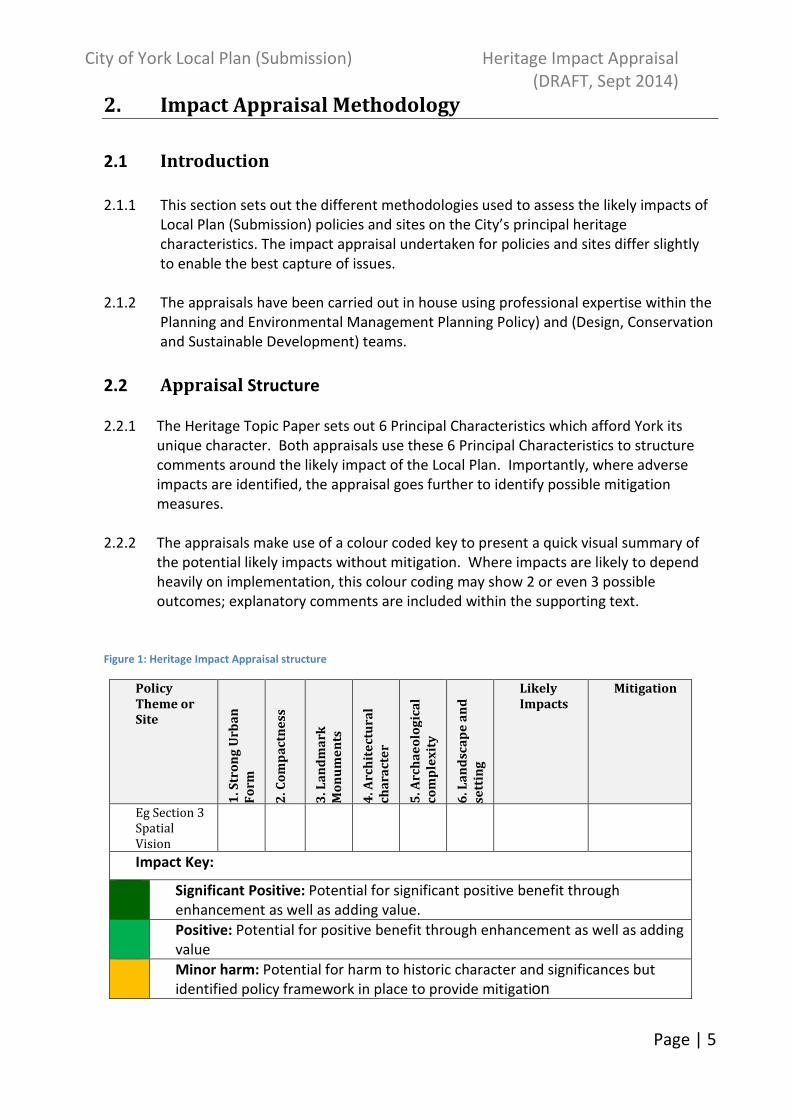
2.2 Appraisal Structure
2.2.1 The Heritage Topic Paper sets out 6 Principal Characteristics which afford York its
unique character. Both appraisals use these 6 Principal Characteristics to structure
comments around the likely impact of the Local Plan. Importantly, where adverse
impacts are identified, the appraisal goes further to identify possible mitigation
measures.
2.2.2 The appraisals make use of a colour coded key to present a quick visual summary of
the potential likely impacts without mitigation. Where impacts are likely to depend
heavily on implementation, this colour coding may show 2 or even 3 possible
outcomes; explanatory comments are included within the supporting text.
Figure 1: Heritage Impact Appraisal structure
Policy
Theme or
Site
1. S
tro
ng
Urb
an
Fo
rm
2. C
om
pa
ctn
ess
3. L
an
dm
ark
Mo
nu
me
nts
4. A
rch
ite
ctu
ra
l
ch
ara
cte
r
5. A
rch
ae
olo
gic
al
co
mp
lex
ity
6. L
an
dsc
ap
e a
nd
sett
ing
Likely
Impacts
Mitigation
Eg Section 3
Spatial
Vision
Impact Key:
Significant Positive: Potential for significant positive benefit through
enhancement as well as adding value.
Positive: Potential for positive benefit through enhancement as well as adding
value
Minor harm: Potential for harm to historic character and significances but
identified policy framework in place to provide mitigation

City of York Local Plan (Submission) Heritage Impact Appraisal
(DRAFT, Sept 2014)
Page | 6
Serious harm: Highly likely to cause significant harm leading to loss of historic
character or substantial harm to its significance.
Neutral: Negligible impact and negligible benefit
Unknown: There is insufficient information to determine an impact
2.3 Sites Appraisal
2.3.1 For the Sites appraisal, discussions with colleagues within the Design, Conservation
and Sustainable Development Team and English Heritage led to a two-stage
methodology being developed to enable a baseline position to be established for all
reasonable alternatives, followed by a more detailed evaluation for strategic sites and
allocations (where further information has been submitted):
2.3.2 Stage 1: Rapid Assessment of all Strategic Sites, Allocations and reasonable
alternatives: All sites considered as ‘reasonable alternatives’ have been subject to a
rapid appraisal. Using the structure detailed in Figure 1 above, the resultant matrix
indicates the contribution a site makes against each principal characteristics and what
the likely impacts development may have in this location. It is intended that that this
analysis will form the baseline position for the site, on which future analysis and
decision making in relation to the historic environment can be based. The assessments
for this stage 1 will be iterative to allow for different site boundaries to be considered
for each site.
2.3.3 Stage 2: Assessing the Strategic Sites, Allocations and reasonable alternatives: The
stage 2 assessment allows a fuller appraisal of the likely impacts of development. This
stage will build upon the stage 1 assessment to understand how the proposals are
likely to impact on the special qualities and characteristics identified and suggest
measures which may be implemented to mitigate against potential harmful impacts.
This stage uses the full characteristics framework as set out in the Heritage Topic Paper
as the basis for analysis. The framework would therefore consider:
Figure 2: Stage 2 Sites Appraisal
Character
Elements
Key features
1. Strong Urban Form
1.1 Large urban blocks Mixed use blocks composed of taller (3-5 storey)
buildings facing the street with lower extensions and ad-
hoc smaller structures behind and within the blocks,
retained private yards. Blocks strongly enclose streets.
1.2 Long narrow plots
and gates side
passages
Usually reflecting medieval or earlier building plots with
side access to former workshops and gardens.
1.3 Framed shop fronts Variety of good quality ‘frames’ around shop windows,
providing visual support to building above whilst
allowing interaction with the street. Usually associated
with smaller retail premises.
City of York Local Plan (Submission) Heritage Impact Appraisal
(DRAFT, Sept 2014)
Page | 7
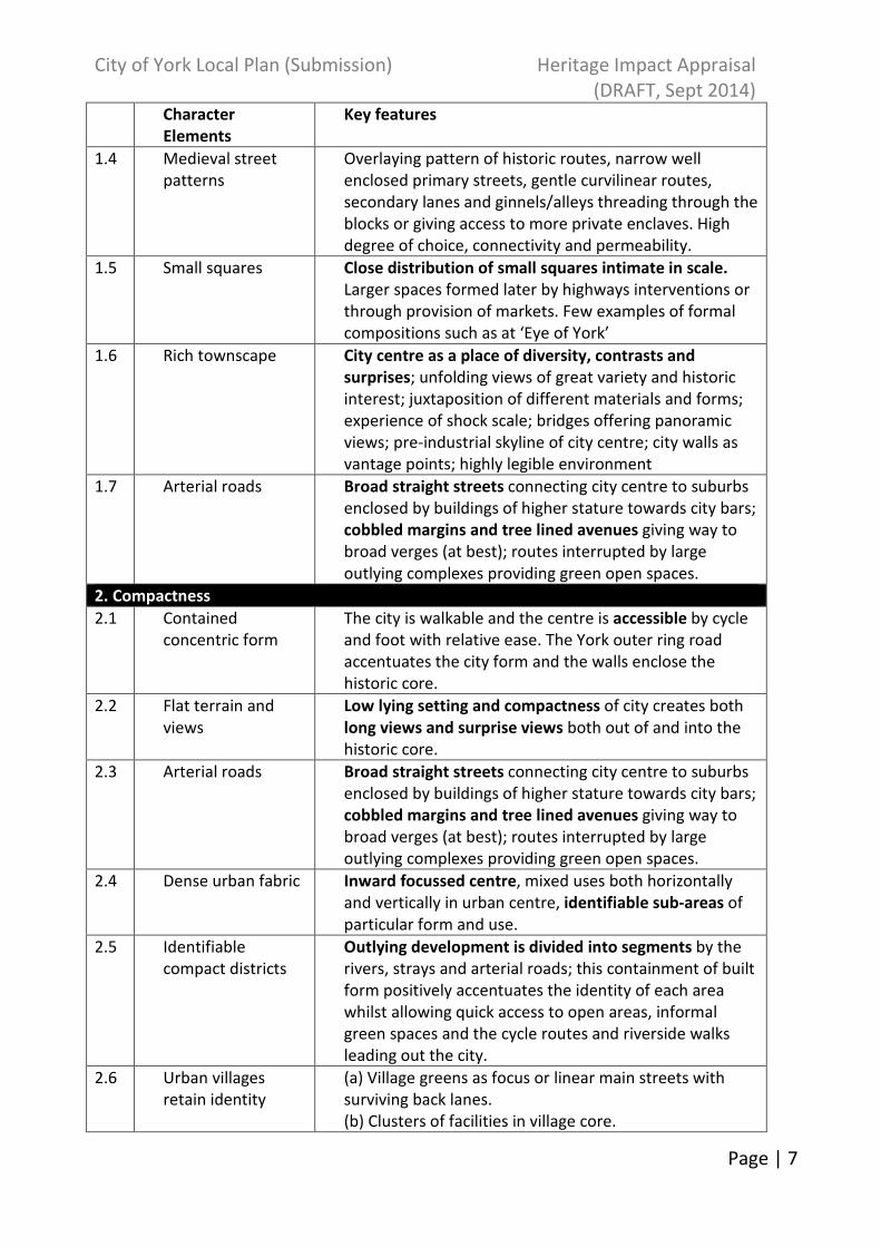
Character
Elements
Key features
1.4 Medieval street
patterns
Overlaying pattern of historic routes, narrow well
enclosed primary streets, gentle curvilinear routes,
secondary lanes and ginnels/alleys threading through the
blocks or giving access to more private enclaves. High
degree of choice, connectivity and permeability.
1.5 Small squares Close distribution of small squares intimate in scale.
Larger spaces formed later by highways interventions or
through provision of markets. Few examples of formal
compositions such as at ‘Eye of York’
1.6 Rich townscape City centre as a place of diversity, contrasts and
surprises; unfolding views of great variety and historic
interest; juxtaposition of different materials and forms;
experience of shock scale; bridges offering panoramic
views; pre-industrial skyline of city centre; city walls as
vantage points; highly legible environment
1.7 Arterial roads Broad straight streets connecting city centre to suburbs
enclosed by buildings of higher stature towards city bars;
cobbled margins and tree lined avenues giving way to
broad verges (at best); routes interrupted by large
outlying complexes providing green open spaces.
2. Compactness
2.1 Contained
concentric form
The city is walkable and the centre is accessible by cycle
and foot with relative ease. The York outer ring road
accentuates the city form and the walls enclose the
historic core.
2.2 Flat terrain and
views
Low lying setting and compactness of city creates both
long views and surprise views both out of and into the
historic core.
2.3 Arterial roads Broad straight streets connecting city centre to suburbs
enclosed by buildings of higher stature towards city bars;
cobbled margins and tree lined avenues giving way to
broad verges (at best); routes interrupted by large
outlying complexes providing green open spaces.
2.4 Dense urban fabric Inward focussed centre, mixed uses both horizontally
and vertically in urban centre, identifiable sub-areas of
particular form and use.
2.5 Identifiable
compact districts
Outlying development is divided into segments by the
rivers, strays and arterial roads; this containment of built
form positively accentuates the identity of each area
whilst allowing quick access to open areas, informal
green spaces and the cycle routes and riverside walks
leading out the city.
2.6 Urban villages
retain identity
(a) Village greens as focus or linear main streets with
surviving back lanes.
(b) Clusters of facilities in village core.

City of York Local Plan (Submission) Heritage Impact Appraisal
(DRAFT, Sept 2014)
Page | 8
Character
Elements
Key features
2.7 Planned rural
villages
Enduring form of curving linear main street with burgage
plots running to historic back lanes; broad planted verges
common feature of main artery, later infilling and minor
extensions often protect historic grain, openness, and
views out to the countryside.
3. Landmark Monuments
3.1 Buildings of high
cultural significance
Visually, aesthetically and historically interesting and
sometimes associated with historical events and specific
individuals.
3.2 Physical and
temporal
landmarks
(a) The Minster in particular can be viewed from the
Wolds, Moors and Dales. The walls are ever present and
a perambulation of them will reveal many of the City’s
monuments including Terry’s and the Nestle Factory.
(b) Clifford’s Tower is particularly associated with
historical events. The Civil War is associated with the
Bars. The Eye of York with Luddites.
3.3 Substantial number
of medieval
communal
buildings
Buildings that reflect functional importance as civic
centres, places of justice, work and religious activity.
3.4 Monument
clustering
There is very little dispersion and most principle
monuments are sited within the historic core and there
is a degree of inter-visibility, especially from the City
Walls.
3.5 Quantity of
monuments
York has a higher than average number of listed
buildings and other principle monuments
3.6 Diversity of
monuments
Diversity ranges from substantial limestone structures
like the Minster to Timber framed Barley Hall and
Merchant Adventurers Hall. From domestic buildings to
brick built railway headquarters and 19th
-20th
century
factories.
3.7 Churches locked
into urban fabric
Provide pockets of green space within dense urban
blocks and are a haven for wildlife.
4. Architectural Character
4.1 Architectural legacy Buildings representing two thousand years of
architectural development in close proximity to each
other.
4.2 Variety The fine grain of urban blocks accommodates a
tremendous range of building types from all ages. Few
streets have consistent themes, though streets have
formed their own identity.
4.3 Human scale The limits of natural materials and techniques have
ensured that human scale buildings predominate.
Narrow plot boundaries assist in developing rhythm.
Where these limits have been exceeded to create

City of York Local Plan (Submission) Heritage Impact Appraisal
(DRAFT, Sept 2014)
Page | 9
Character
Elements
Key features
factories, warehouses, office blocks, they have simple
massing and are clustered on low ground close to the
station of within extra mural compounds. Even so height
is restrained, roof-tops acknowledge with modelling or
decorative parapets, and facades have a level of detailed
consideration.
4.4 Craftsmanship Highly skilled craftsmen and artists have benefited from
religious and secular patronage through-out York’s
history. Of particular significance are: stained glass,
stone carving, carpentry and timber relief work, wrought
and cast ironwork, monuments, brasses, bells and public
statuary
5. Architectural Complexity
5.1
Exceptional
preservation in
historic core
Timber foundations of Anglo-Scandinavian houses have
been found well preserved in Coppergate and Hungate.
Food waste and other similar organic waste is well
preserved giving invaluable insight into diet, health,
economy that is lacking in more conventional
archaeological deposits
5.2 Depth of deposits
in the historic core
Remains of successive development from Roman
through to the present day.
5.3 2000 years of
urban development
Archaeological deposits relating to at least Roman
through to the present day
5.4 Finite and non-
renewable
resource
(a) Anaerobic deposits that are extremely dependant on
sustained ground conditions. Fluctuating water table
creates pressures on the continued preservation of these
deposits.
(b) Any form of deposit removal, even by archaeologists
in a controlled and recorded manner will destroy
important evidence and information.
5.5 Majority of known
and unknown
archaeological
features and
deposits are not
designated heritage
assets.
The York HER contains some 6000 records relating to the
archaeology of York and its surroundings which is only a
small percentage of what actually remains.
6. Landscape and Setting
6.1 Views in and out (a) Long-distance views of York Minster in low-lying
relatively flat vale landscape. The Minster constantly
reappears at closer quarters.
(b) View of the race course/Knavesmire and Terrys
combined.
(c) Rural edge setting viewed from majority of ring road
by way of field margin (northern ring road business parks

City of York Local Plan (Submission) Heritage Impact Appraisal
(DRAFT, Sept 2014)
Page | 10
Character
Elements
Key features
exception to rule).
(d) Views out to the Wolds, Moors and the Howardian
Hills (orientation, identity, and sense of location/setting).
6.2 Strays
(including
racecourse)
and common land
Openness; greenness; natural/rural character within city.
Village greens.
6.3 Rivers and Ings (a) Derwent/Ouse: Flooding; Ings meadows; retention of
traditional management over centuries - still hay
cropped and grazed where possible.
(b) Ouse - walking along most of either bank north to
Beningborough hall, south past Bishops palace. Activity
on river - rowing (3 clubs) dating back to mid 19th
century.
(c) Foss – two rivers converging in city centre; walkway
from centre to countryside beyond ring road; linking
villages – the ‘hidden’ river.
(d) Views along river/banks.
6.4 Open countryside
and green belt
(a) The open countryside surrounding York contributes
to the landscape setting of the historic City;
(b) A wide variety of different habitats and landscape
elements including: Lowland heath; wet acidic grassland;
rich hedgerows; valley fen; open Ings landscape
associated with river; wiildflower meadows;
(c) Airfields with large expanse of openness/cultural
heritage/habitat value;
(d) Village settings including: assorted land; strip field
pattern/ridge and furrow; hedgerows; veteran orchards.
(e) Long distance uninterrupted recreation routes with
cultural significance through countryside
(f) Orchards – vale of York high orchard productivity
historically; veteran Pear and apple trees often in
gardens of later development.
6.5 Suburban villages Street trees, public parks, large gardens, ‘quiet streets’,
pedestrian-friendly environment, strong community
identity, allotments, front gardens bound by hedges
6.6 Parks and Gardens (a) Registered historic parks and gardens
(b) Parks for the people
(c) Designed campus landscape
(d) Matrix of accessible parks
6.7 Relationship of the
historic city of York
to the surrounding
villages
The relationship of York to its surrounding settlements.
This relationship derives from:-
(a) the distance between the settlements
(b) the size of the villages themselves,
(c) the fact that they are free-standing, clearly definable

City of York Local Plan (Submission) Heritage Impact Appraisal
(DRAFT, Sept 2014)
Page | 11
Character
Elements
Key features
settlements

City of York Local Plan (Submission) Heritage Impact Appraisal
(DRAFT, Sept 2014)
Page | 12
3. Outcomes of Local Plan Policy Appraisal
3.1 Introduction
3.1.1 The following table presents the outcomes of the Heritage Impact Appraisal of emerging Local Plan (Submission) policies.
++ Significant Positive: Potential for significant positive benefit through enhancement as well as adding value.
- Minor harm: Potential for harm to historic character and significances but identified policy framework in place to provide mitigation
+ Positive: Potential for positive benefit through enhancement as well as adding value
_ _ Serious harm: Highly likely to cause significant harm leading to loss of historic character or substantial harm to its significance.
O Neutral: Negligible impact and negligible benefit ? Unknown: There is insufficient information to determine an impact.
Policy Theme Principal Characteristics Likely Impacts Mitigation
1 2 3 4 5 6
Str
on
g U
rba
n
Fo
rm
Co
mp
ac
tne
ss
La
nd
ma
rk
Mo
nu
me
nts
Arc
hit
ec
tur
al
ch
ara
cte
r
Arc
ha
eo
log
ica
l
co
mp
lex
ity
La
nd
sca
pe
an
d
sett
ing
Section 2: Vision and
Development
Principles
Policy DP1: York Sub Area
++ ++ ++ ++ ++ ++ This describes York’s role and function within the wider sub-region. It continues to focus growth on York City Centre, further enhancing the city’s
n/a
City of York Local Plan (Submission) Heritage Impact Appraisal
(DRAFT, Sept 2014)
Page | 13
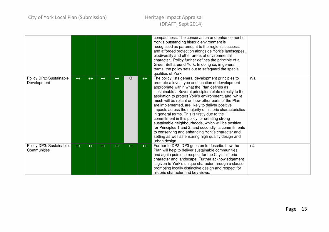
compactness. The conservation and enhancement of York’s outstanding historic environment is recognised as paramount to the region’s success, and afforded protection alongside York’s landscapes, biodiversity and other areas of environmental character. Policy further defines the principle of a Green Belt around York. In doing so, in general terms, the policy sets out to safeguard the special qualities of York.
Policy DP2: Sustainable Development
++ ++ ++ ++ O ++ The policy lists general development principles to promote a level, type and location of development appropriate within what the Plan defines as ‘sustainable’. Several principles relate directly to the aspiration to protect York’s environment, and, while much will be reliant on how other parts of the Plan are implemented, are likely to deliver positive impacts across the majority of historic characteristics in general terms. This is firstly due to the commitment in this policy for creating strong sustainable neighbourhoods, which will be positive for Principles 1 and 2, and secondly its commitments to conserving and enhancing York’s character and setting as well as ensuring high quality design and urban design.
n/a
Policy DP3: Sustainable Communities
++ ++ ++ ++ ++ ++ Further to DP2, DP3 goes on to describe how the Plan will help to deliver sustainable communities, and again points to respect for the City’s historic character and landscape. Further acknowledgement is given to York’s unique character through a clause promoting locally distinctive design and respect for historic character and key views.
n/a

City of York Local Plan (Submission) Heritage Impact Appraisal
(DRAFT, Sept 2014)
Page | 14
1 The spatial strategy lists a number of sites which will have been subject to Heritage Impact Appraisal as part of the HIA (SITES) document. It should be noted that the HIA
(SITES) document appraises the principle of development on a site, but not a specific development type or level. The policy in the Local Plan (appraised here) tells us more
about the type, level and location of development on a site, and should respond to the points raised by the HIA (SITES) document, including suggested mitigation measures. As
such, the 2 appraisals may have differing conclusions.
Policy DP4: Approach to Development Management
++ ++ ++ ++ ++ ++ This policy’s role is to guide development in accordance with local plan policies, and as such should help to deliver places which respect and enhance York’s special qualities.
n/a
Section 3: Spatial
Strategy1
Policy SS1: Delivering Sustainable Growth in York
++ ++ ++ ++ ++ ++ SS1 guides development to brownfield sites, with emphasis on protecting the character and setting of the City and its wider historic and natural environment. It continues to focus growth on York City Centre, further enhancing the city’s compactness. In doing so, in general terms, the policy sets out to safeguard the special qualities of York.
Policy SS2: The Role of York’s Green Belt
++ ++ O O O ++ Further to DP1, SS2 describes the primary purpose of the Green Belt as to preserve the setting and the special character of York.
Policy SS3: The Creation of an Enduring Green Belt
++ ++ O O O ++ SS3 identifies ‘safeguarded’ land, excluded from the green belt, which may be needed for development following the Plan’s review. This helps to ensure the green belt’s permanence.
Policy SS4:York City Centre
+ ++ ++ + + + This policy is likely to have a positive or significantly positive impact on all of the characteristics as it recognises York’s City Centre as the hub of the city and seeks to conserve and enhance its special qualities and distinctiveness as well as its setting and heritage assets.
n/a
Policy SS5: Whinthorpe Area of Change
O
O - O - - O O - The Heritage Impact Appraisal (SITES) identifies a number of negative impacts likely as a result of developing in this location. Policy SS5 addresses these as follows (HIA (SITES) comment in italics,
- Implement this policy alongside others in the Plan (especially those contained within Section 8: Design and

City of York Local Plan (Submission) Heritage Impact Appraisal
(DRAFT, Sept 2014)
Page | 15
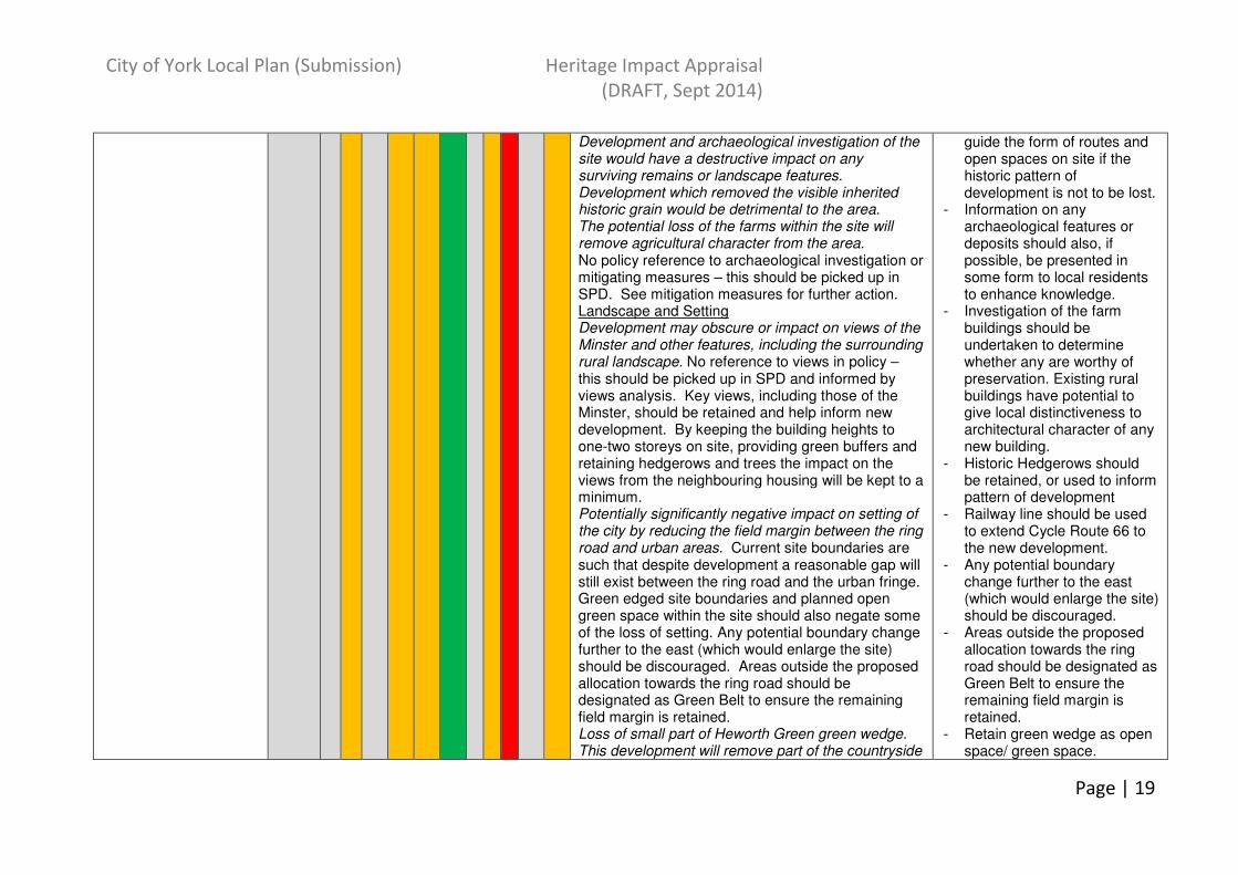
with HIA (POLICIES) response in normal text): In general, the policy advises that Whinthorpe will be supported by detailed planning guidance to guide implementation through the preparation of a SPD, which will contain further detail on policy SS5. This must be guided by sufficient appraisal and understanding to inform a scheme which responds well to its context and delivers a new place with its own character. Strong Urban Form No likely impacts identified. No likely impact identified. Compactness Potentially negative impact on compactness, although existing field margin suggests a separate settlement rather than an extension to York itself. Policy requires a significant buffer to the A64, in order that the development reads as a separate settlement, and sits within its own landscape context. Potential to harm experience of views to the city centre by providing another focus. No reference to views – this should be picked up in SPD and informed by views analysis. Landmark Monuments Development may obscure or impact on views of the Minster and other features. No reference to views – this should be picked up in SPD and informed by views analysis. Views of Minster should be retained in new development. Architectural Character Poor architectural design, including inappropriately
Placemaking) to mitigate and minimise harm as well as maximise enhancement opportunities.
- Ensure SPD is informed by clear appraisal and understanding of the site’s characteristics (in particular views appraisal), and that future development masterplanning is contextually relevant and references the best in contemporary placemaking.
- Reducing the settlement size and/or moving further from the ring road/Heslington may further reinforce Whinthorpe as a free-standing settlement.
- Further archaeological investigation by geophysical survey and evaluation trenching is needed to provide further information and evidence to the archaeological record. Mititgation by recording and avoidance.
- Inspection of ridge and furrow should take place to decide which areas merit preservation as part of open space.
- Historic field boundaries should be retained and enhanced where possible or at least respected in the

City of York Local Plan (Submission) Heritage Impact Appraisal
(DRAFT, Sept 2014)
Page | 16
tall buildings, would be detrimental to the generally high quality of buildings and craftsmanship in York. Policy makes no mention of design aspirations - site should create an independent identity informed by contextual appraisals and the best of contemporary placemaking. Archaeological Complexity Development and archaeological investigation of the site would have a destructive impact on any surviving remains or landscape features. Development which removed the visible inherited historic grain would be detrimental to the area. The potential loss of the farms within the site will remove agricultural character from the area. No reference to archaeological investigation or mitigating measures – this should be picked up in SPD. See mitigation measures for further action. Landscape and Setting Significantly negative impact on setting of the city by development encroaching up to the ring road. Changes the relationship between the southern edge of York and the surrounding open countryside. Policy requires a significant buffer to the A64, in order that the development reads as a separate settlement, and sits within its own landscape context. Whinthorpe would be a distinct, freestanding settlement, close to the City’s fringe. It would lie close to the outskirts of Elvington and Heslington. The relationship of York to its surrounding settlements is a key element of the City’s character. Policy requires a significant buffer to the A64, in order that the development reads as a separate settlement, and sits within its own landscape context. Reducing the settlement size and/or moving further from the ring road/Heslington may further reinforce Whinthorpe as a free-standing settlement.
design of the new development. Further assessment needed to identify the most significant of these.
- Existing tracks and plantations should be used to guide the form of routes and open spaces on site if the historic pattern of development is not to be lost.
- Information on any archaeological features or deposits should also, if possible, be presented in some form to local residents to enhance knowledge.
- Investigation of the farm buildings should be undertaken to determine whether any are worthy of preservation. Existing rural buildings have potential to give local distinctiveness to architectural character of any new building.
- Carefully designed landscaping and buffering, alongside high tree cover, should help protect the development’s rural setting.
- Information should be provided within the development on the significance of the nearby SINC/SSSI sites as well as historic features.
City of York Local Plan (Submission) Heritage Impact Appraisal
(DRAFT, Sept 2014)
Page | 17
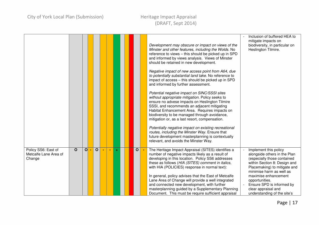
Development may obscure or impact on views of the Minster and other features, including the Wolds. No reference to views – this should be picked up in SPD and informed by views analysis. Views of Minster should be retained in new development. Negative impact of new access point from A64, due to potentially substantial land take. No reference to impact of access – this should be picked up in SPD and informed by further assessment. Potential negative impact on SINC/SSSI sites without appropriate mitigation. Policy seeks to ensure no advese impacts on Heslington Tilmire SSSI, and recommends an adjacent mitigating Habitat Enhancement Area. Requires impacts on biodiversity to be managed through avoidance, mitigation or, as a last resort, compensation. Potentially negative impact on existing recreational routes, including the Minster Way. Ensure that future development masterplanning is contextually relevant, and avoids the Minster Way.
- Inclusion of buffered HEA to mitigate impacts on biodiversity, in particular on Heslington Tilmire.
Policy SS6: East of Metcalfe Lane Area of Change
O O - O - - + O - The Heritage Impact Appraisal (SITES) identifies a number of negative impacts likely as a result of developing in this location. Policy SS6 addresses these as follows (HIA (SITES) comment in italics, with HIA (POLICIES) response in normal text): In general, policy advises that the East of Metcalfe Lane Area of Change will provide a well integrated and connected new development, with further masterplanning guided by a Supplementary Planning Document. This must be require sufficient appraisal
- Implement this policy alongside others in the Plan (especially those contained within Section 8: Design and Placemaking) to mitigate and minimise harm as well as maximise enhancement opportunities.
- Ensure SPD is informed by clear appraisal and understanding of the site’s
City of York Local Plan (Submission) Heritage Impact Appraisal
(DRAFT, Sept 2014)
Page | 18
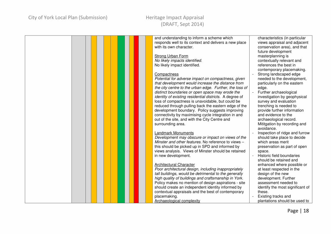
and understanding to inform a scheme which responds well to its context and delivers a new place with its own character. Strong Urban Form No likely impacts identified. No likely impact identified. Compactness Potential for adverse impact on compactness, given that development would increase the distance from the city centre to the urban edge. Further, the loss of distinct boundaries or open space may erode the identity of existing residential districts. A degree of loss of compactness is unavoidable, but could be reduced through pulling back the eastern edge of the development boundary. Policy suggests improving connectivity by maximising cycle integration in and out of the site, and with the City Centre and surrounding area. Landmark Monuments Development may obscure or impact on views of the Minster and other features. No reference to views – this should be picked up in SPD and informed by views analysis. Views of Minster should be retained in new development. Architectural Character Poor architectural design, including inappropriately tall buildings, would be detrimental to the generally high quality of buildings and craftsmanship in York. Policy makes no mention of design aspirations - site should create an independent identity informed by contextual appraisals and the best of contemporary placemaking. Archaeological complexity
characteristics (in particular views appraisal and adjacent conservation area), and that future development masterplanning is contextually relevant and references the best in contemporary placemaking.
- Strong landscaped edge needed to the development, particularly on the eastern edge.
- Further archaeological investigation by geophysical survey and evaluation trenching is needed to provide further information and evidence to the archaeological record. Mititgation by recording and avoidance.
- Inspection of ridge and furrow should take place to decide which areas merit preservation as part of open space.
- Historic field boundaries should be retained and enhanced where possible or at least respected in the design of the new development. Further assessment needed to identify the most significant of these.
- Existing tracks and plantations should be used to
City of York Local Plan (Submission) Heritage Impact Appraisal
(DRAFT, Sept 2014)
Page | 19
Development and archaeological investigation of the site would have a destructive impact on any surviving remains or landscape features. Development which removed the visible inherited historic grain would be detrimental to the area. The potential loss of the farms within the site will remove agricultural character from the area. No policy reference to archaeological investigation or mitigating measures – this should be picked up in SPD. See mitigation measures for further action. Landscape and Setting Development may obscure or impact on views of the Minster and other features, including the surrounding rural landscape. No reference to views in policy – this should be picked up in SPD and informed by views analysis. Key views, including those of the Minster, should be retained and help inform new development. By keeping the building heights to one-two storeys on site, providing green buffers and retaining hedgerows and trees the impact on the views from the neighbouring housing will be kept to a minimum. Potentially significantly negative impact on setting of the city by reducing the field margin between the ring road and urban areas. Current site boundaries are such that despite development a reasonable gap will still exist between the ring road and the urban fringe. Green edged site boundaries and planned open green space within the site should also negate some of the loss of setting. Any potential boundary change further to the east (which would enlarge the site) should be discouraged. Areas outside the proposed allocation towards the ring road should be designated as Green Belt to ensure the remaining field margin is retained. Loss of small part of Heworth Green green wedge. This development will remove part of the countryside
guide the form of routes and open spaces on site if the historic pattern of development is not to be lost.
- Information on any archaeological features or deposits should also, if possible, be presented in some form to local residents to enhance knowledge.
- Investigation of the farm buildings should be undertaken to determine whether any are worthy of preservation. Existing rural buildings have potential to give local distinctiveness to architectural character of any new building.
- Historic Hedgerows should be retained, or used to inform pattern of development
- Railway line should be used to extend Cycle Route 66 to the new development.
- Any potential boundary change further to the east (which would enlarge the site) should be discouraged.
- Areas outside the proposed allocation towards the ring road should be designated as Green Belt to ensure the remaining field margin is retained.
- Retain green wedge as open space/ green space.

City of York Local Plan (Submission) Heritage Impact Appraisal
(DRAFT, Sept 2014)
Page | 20
surrounding the city. Development which would remove open countryside features would have a detrimental impact on this character element without mitigation. In particular, construction of housing against the northern edge of Osbaldwick would destroy its historic rural setting. Policy requires a green wedge to be established to protect the corridor of South Beck and maintain the distinction between Heworth and Tang Hall. Removing development from this wedge and instead providing green space/open space would help maintain its openness.
- Ensure no development further to the east of the current proposed boundaries.
- Incorporate as much of a green buffer between the rural setting and proposed development. Green edges and buffering required for the eastern edge of the site and to boundaries of existing settlements.
- Retain reasonable farmstead buildings and possibly some function and a sufficient degree of context and retain the sense of identity and historic connection that such complexes provide.
- The SINC site is outside the proposed development boundary. Appropriate buffering to the edge of the SINC and development should be put in place.
- No development against the northern edge of Osbaldwick. The fields immediately north of the village, which include the SINC site, and part of the Green Belt should remain open. This would mitigate some of the impact on the immediate setting of the village.
- Clear margin needed between Conservation Area of Osbaldwick and the new

City of York Local Plan (Submission) Heritage Impact Appraisal
(DRAFT, Sept 2014)
Page | 21
development. - Selected areas of ridge and
furrow should also be retained where possible as part of the planned open space.
- Low building heights and low-medium housing densities may also minimise the impact on the rural setting of the city.
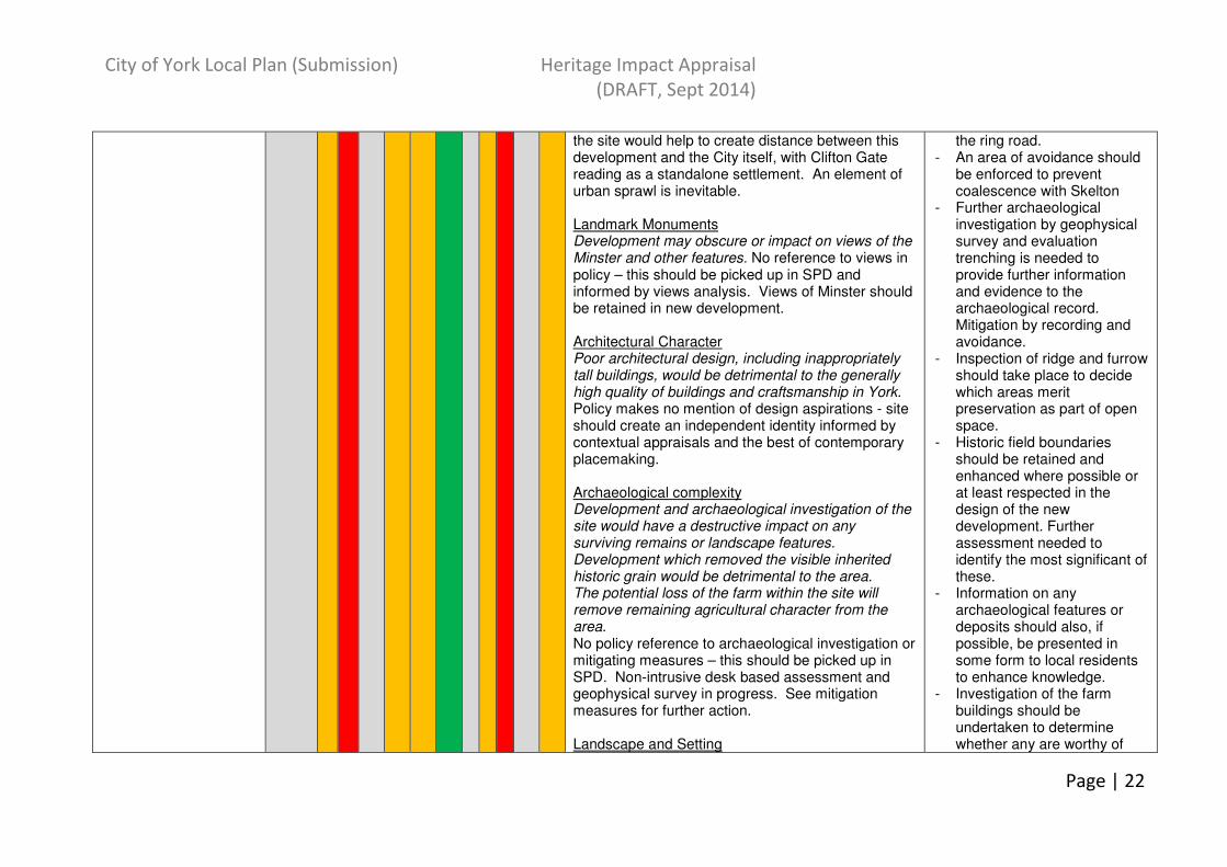
Policy SS7: Clifton Gate Area of Change
O - --
O - - + The Heritage Impact Appraisal (SITES) identifies a number of negative impacts likely as a result of developing in this location. Policy SS7 addresses these as follows (HIA (SITES) comment in italics, with HIA (POLICIES) response in normal text): In general, policy advises that Land North of Clifton Moor will deliver a mix of housing, community facilities and infrastructure, with further masterplanning guided by a Supplementary Planning Document. This must require sufficient appraisal and understanding to inform a scheme which responds well to its context and delivers a new place with its own character. Strong Urban Form No likely impacts identified. No likely impact identified. Compactness Potential significant negative impacts from urban sprawl – would extend development beyond the confines of the ring road. Policy promotes landscape buffers around the site to prevent coalescence with adjacent settlements and maintain the setting of Skelton. Further greenspace buffers to the south of
- Implement this policy alongside others in the Plan (especially those contained within Section 8: Design and Placemaking) to mitigate and minimise harm as well as maximise enhancement opportunities.
- Ensure SPD is informed by clear appraisal and understanding of the site’s characteristics (in particular views appraisal and the significance of the SLI/airfield), and that future development masterplanning is contextually relevant and references the best in contemporary placemaking.
- Impact on compactness and on the setting of the city could be mitigated through sensitive masterplanning, reducing the scale of the overall site and/or increasing the green space buffer with
City of York Local Plan (Submission) Heritage Impact Appraisal
(DRAFT, Sept 2014)
Page | 22
the site would help to create distance between this development and the City itself, with Clifton Gate reading as a standalone settlement. An element of urban sprawl is inevitable. Landmark Monuments Development may obscure or impact on views of the Minster and other features. No reference to views in policy – this should be picked up in SPD and informed by views analysis. Views of Minster should be retained in new development. Architectural Character Poor architectural design, including inappropriately tall buildings, would be detrimental to the generally high quality of buildings and craftsmanship in York. Policy makes no mention of design aspirations - site should create an independent identity informed by contextual appraisals and the best of contemporary placemaking. Archaeological complexity Development and archaeological investigation of the site would have a destructive impact on any surviving remains or landscape features. Development which removed the visible inherited historic grain would be detrimental to the area. The potential loss of the farm within the site will remove remaining agricultural character from the area. No policy reference to archaeological investigation or mitigating measures – this should be picked up in SPD. Non-intrusive desk based assessment and geophysical survey in progress. See mitigation measures for further action. Landscape and Setting
the ring road. - An area of avoidance should
be enforced to prevent coalescence with Skelton
- Further archaeological investigation by geophysical survey and evaluation trenching is needed to provide further information and evidence to the archaeological record. Mitigation by recording and avoidance.
- Inspection of ridge and furrow should take place to decide which areas merit preservation as part of open space.
- Historic field boundaries should be retained and enhanced where possible or at least respected in the design of the new development. Further assessment needed to identify the most significant of these.
- Information on any archaeological features or deposits should also, if possible, be presented in some form to local residents to enhance knowledge.
- Investigation of the farm buildings should be undertaken to determine whether any are worthy of
City of York Local Plan (Submission) Heritage Impact Appraisal
(DRAFT, Sept 2014)
Page | 23
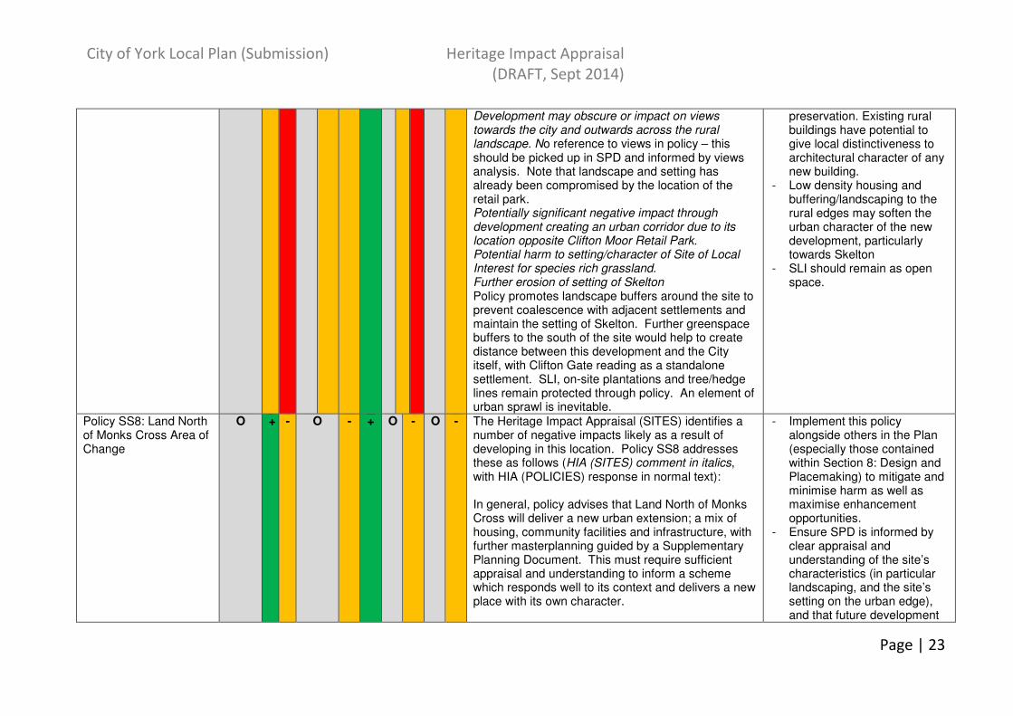
Development may obscure or impact on views towards the city and outwards across the rural landscape. No reference to views in policy – this should be picked up in SPD and informed by views analysis. Note that landscape and setting has already been compromised by the location of the retail park. Potentially significant negative impact through development creating an urban corridor due to its location opposite Clifton Moor Retail Park. Potential harm to setting/character of Site of Local Interest for species rich grassland. Further erosion of setting of Skelton Policy promotes landscape buffers around the site to prevent coalescence with adjacent settlements and maintain the setting of Skelton. Further greenspace buffers to the south of the site would help to create distance between this development and the City itself, with Clifton Gate reading as a standalone settlement. SLI, on-site plantations and tree/hedge lines remain protected through policy. An element of urban sprawl is inevitable.
preservation. Existing rural buildings have potential to give local distinctiveness to architectural character of any new building.
- Low density housing and buffering/landscaping to the rural edges may soften the urban character of the new development, particularly towards Skelton
- SLI should remain as open space.
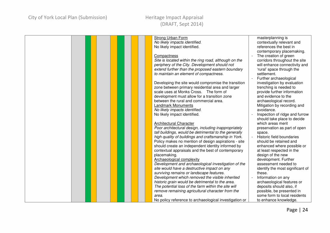
Policy SS8: Land North of Monks Cross Area of Change
O + - O - + O - O - The Heritage Impact Appraisal (SITES) identifies a number of negative impacts likely as a result of developing in this location. Policy SS8 addresses these as follows (HIA (SITES) comment in italics, with HIA (POLICIES) response in normal text): In general, policy advises that Land North of Monks Cross will deliver a new urban extension; a mix of housing, community facilities and infrastructure, with further masterplanning guided by a Supplementary Planning Document. This must require sufficient appraisal and understanding to inform a scheme which responds well to its context and delivers a new place with its own character.
- Implement this policy alongside others in the Plan (especially those contained within Section 8: Design and Placemaking) to mitigate and minimise harm as well as maximise enhancement opportunities.
- Ensure SPD is informed by clear appraisal and understanding of the site’s characteristics (in particular landscaping, and the site’s setting on the urban edge), and that future development
City of York Local Plan (Submission) Heritage Impact Appraisal
(DRAFT, Sept 2014)
Page | 24
Strong Urban Form No likely impacts identified. No likely impact identified. Compactness Site is located within the ring road, although on the periphery of the City. Development should not extend further than the proposed eastern boundary to maintain an element of compactness. Developing the site would compromise the transition zone between primary residential area and larger scale uses at Monks Cross. The form of development must allow for a transition zone between the rural and commercial area. Landmark Monuments No likely impacts identified. No likely impact identified. Architectural Character Poor architectural design, including inappropriately tall buildings, would be detrimental to the generally high quality of buildings and craftsmanship in York. Policy makes no mention of design aspirations - site should create an independent identity informed by contextual appraisals and the best of contemporary placemaking. Archaeological complexity Development and archaeological investigation of the site would have a destructive impact on any surviving remains or landscape features. Development which removed the visible inherited historic grain would be detrimental to the area. The potential loss of the farm within the site will remove remaining agricultural character from the area. No policy reference to archaeological investigation or
masterplanning is contextually relevant and references the best in contemporary placemaking.
- The creation of green corridors throughout the site will enhance connectivity and ‘rural’ space through the settlement.
- Further archaeological investigation by evaluation trenching is needed to provide further information and evidence to the archaeological record. Mitigation by recording and avoidance.
- Inspection of ridge and furrow should take place to decide which areas merit preservation as part of open space.
- Historic field boundaries should be retained and enhanced where possible or at least respected in the design of the new development. Further assessment needed to identify the most significant of these.
- Information on any archaeological features or deposits should also, if possible, be presented in some form to local residents to enhance knowledge.

City of York Local Plan (Submission) Heritage Impact Appraisal
(DRAFT, Sept 2014)
Page | 25
mitigating measures – this should be picked up in SPD. Non-intrusive desk based assessment undertaken. Geophysical survey complete. See mitigation measures for further action. Landscape and Setting Development of the site would reduce the field margin between the ring road and urban areas, impacting on the open rural setting of the city. The proposed area of development runs up to the ring road at its north-east corner thereby potentially removing the field margin altogether and altering the rural character of North Lane which continues on the other side of the A1237. Policy advocates strategic greenspace, in part to safeguard the setting of the city and retain key strategic views towards the Minster. The loss of the remaining agricultural land here would further erode the village setting of Huntington. Several strip fields, historic field boundaries and ridge and furrow associated with the village exist across the site. Policy advocates strategic greenspace, in part to conserve on-site assets including ridge and furrow, hedgerows and trees, that also contribute to the setting of Huntington.
- Ways of incorporating some of the farm buildings into the new development should be explored. Green buffering should be used to maintain a rural image when looking from Galtres Farm to the new development.
- Any potential boundary change further to the east should be discouraged. A new Green Belt designation in this area may assist in protecting the remaining field margin here in the future.
Policy SS9: York Central Area of Opportunity
+ ++ O + - + O - --
O The Heritage Impact Appraisal (SITES) identifies a number of negative impacts likely as a result of developing in this location. Policy SS9 addresses these as follows (HIA (SITES) comment in italics, with HIA (POLICIES) response in normal text): In general, York Central offers an area of opportunity promoting mixed use development including a new CBD, expanded and new cultural and visitor facilities, and a new residential community. Development on site will be guided by a Supplementary Planning Document. This must
- Implement this policy alongside others in the Plan (especially those contained within Section 8: Design and Placemaking) to mitigate and minimise harm as well as maximise enhancement opportunities.
- Ensure SPD is informed by clear appraisal and understanding of the site’s characteristics (in particular

City of York Local Plan (Submission) Heritage Impact Appraisal
(DRAFT, Sept 2014)
Page | 26
require sufficient appraisal and understanding to inform a scheme which responds well to its context and delivers a new place with its own character. Strong Urban Form Inappropriate development on this site may compromise the views to and from the area – in particular of the Minster and City Walls as well as impact on the setting of some listed buildings. (see also Landscape and Setting). The policy promotes development which new place of outstanding quality and design which complements and enhances the existing historic urban fabric of the city, safeguards those elements which contribute to the distinctive historic character of the city, and assimilates into its setting and surrounding communities. Views appraisal should inform forthcoming SPD and masterplanning to mitigate potential harm. There is also the potential for this policy to have a positive impact on strong urban form, creating a new part of the city representing the best in contemporary design. Compactness Inappropriate development may obscure views of city landmarks such as the Minster or significant elements of the railway infrastructure from within the site and further afield. The policy promotes development which new place of outstanding quality and design which complements and enhances the existing historic urban fabric of the city, safeguards those elements which contribute to the distinctive historic character of the city, and assimilates into its setting and surrounding communities. Views and site appraisal should inform forthcoming SPD and masterplanning to mitigate potential harm. There is also the potential for this policy to have a significant
views appraisal, topography, and the character and setting of landmark buildings, including those of railway interest), and that future development masterplanning is contextually relevant and references the best in contemporary placemaking.
- Appropriate archaeological mitigation strategies such as evaluation and monitoring programmes, should be undertaken as part of the planning process.
- Several areas of archaeological potential have been identified in the York Central Audit of Heritage Assets 2013 on the sites of demolished buildings. This document should also be used when considering the buildings within and surrounding the area.
City of York Local Plan (Submission) Heritage Impact Appraisal
(DRAFT, Sept 2014)
Page | 27
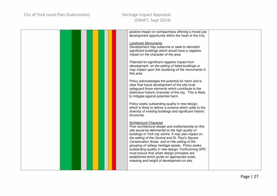
positive impact on compactness offering a mixed use development opportunity within the heart of the City. Landmark Monuments Development may subsume or seek to demolish significant buildings which would have a negative impact on the character of the area Potential for significant negative impact from development on the setting of listed buildings or may impact upon the clustering of the monuments in this area. Policy acknowledges the potential for harm and is clear that future development of the site must safeguard those elements which contribute to the distinctive historic character of the city. This is likely to mitigate against potential harm. Policy seeks outstanding quality in new design, which is likely to deliver a scheme which adds to the diversity of existing buildings and significant historic structures. Architectural Character Poor architectural design and craftsmanship on this site would be detrimental to the high quality of buildings in York city centre. It may also impact on the setting of the Central and St. Paul’s Square Conservation Areas, and on the setting of the grouping of railway heritage assets. Policy seeks outstanding quality in new design. Forthcoming SPD must ensure that urban design principles are established which guide an appropriate scale, massing and height of development on site.

City of York Local Plan (Submission) Heritage Impact Appraisal
(DRAFT, Sept 2014)
Page | 28
Archaeological Complexity The HIA (SITES) recognises the potential for significant harm to surviving archaeological deposits, and to extant heritage assets if area not fully understood. No policy reference to archaeological investigation or mitigating measures – this should be picked up in SPD. Desk-based assessment has been completed ahead of further archaeological investigation. A WSI was agreed for trenching in c.2008 but has yet to be implemented. Landscape and Setting No likely impacts identified No likely impacts identified
Policy SS10: Castle Piccadilly Area of Opportunity
- + --
++
--
O - + - + The Heritage Impact Appraisal (SITES) identifies a number of negative impacts likely as a result of developing in this location. Policy SS10 addresses these as follows (HIA (SITES) comment in italics, with HIA (POLICIES) response in normal text): In general, Castle Piccadilly offers an area of opportunity promoting regeneration and enhancement, quality civic and open space, retail, leisure, residential and employment uses. A planning brief and supporting Conservation Area Character Appraisal exist, forming the basis for understanding the special architectural and historic qualities of the proposed development and its immediate surroundings. These require sufficient appraisal and understanding to inform a scheme which responds well to its context and delivers a new place with its own character. Strong Urban Form Inappropriate development on this site may compromise the views to and from the area – as
- Implement this policy alongside others in the Plan (especially those contained within Section 8: Design and Placemaking) to mitigate and minimise harm as well as maximise enhancement opportunities.
- Ensure SPD is informed by clear appraisal and understanding of the site’s characteristics (in particular views appraisal, topography, and the character and setting of landmark buildings, including those of industrial interest), and that future development masterplanning is contextually relevant and references the best in contemporary placemaking.
- Non-intrusive archaeological

City of York Local Plan (Submission) Heritage Impact Appraisal
(DRAFT, Sept 2014)
Page | 29
well as impact on the setting of some listed buildings. (see also Landscape and Setting). Large scale development may result in the loss of some of the rich 18
thC – 20
thC townscape.
The policy promotes development which: ensures the setting of Clifford’s Tower and the Castle precinct is enhanced and the important views of these historic buildings are maintained; ensures development is of the highest architectural quality, which respects the scale and massing of development in the City Centre; and creates a new open and civic space around the Eye of York and Clifford’s Tower, which is of the highest quality of design, will enhance the historic character and appearance of the area, provide an appropriate setting for Clifford’s Tower and assist in the public’s understanding of the Castle Precinct; As such there, while there is potential for some harm to urban form, there is also potential for urban form to be strengthened using strong architecture at the right scale.
Compactness Re-development will enhance this commercial area of the city centre and bring it closer to the outlying residential areas of Walmgate. Inappropriate development may restrict or remove existing views. Where this may impact upon key views the threat becomes more significant. The policy promotes development which: ensures the setting of Clifford’s Tower and the Castle precinct is enhanced and the important views of these historic buildings are maintained. The CACA says much on this aspect - views and site appraisal should inform future masterplanning to mitigate potential harm. Sensitive redevelopment offers opportunities to open up new views, particularly of the river Foss and castle area from Piccadilly. Landmark Monuments
investigation and analysis of previous investigations should precede any archaeological excavation to assess the nature and significance of any archaeological deposits on site.
- Appropriate archaeological investigation such as trial trenching is needed to assess the nature and significance of any archaeological deposits on site and inform mitigation strategies.

City of York Local Plan (Submission) Heritage Impact Appraisal
(DRAFT, Sept 2014)
Page | 30
Redevelopment may have a detrimental impact on the setting of the listed buildings within and surrounding the site. It may also impact upon the Scheduled Area of the Castle or have a detrimental impact on the Core Conservation Area in general. Inappropriately scaled buildings will have a detrimental affect on the human scale element of this characteristic. The policy promotes development which ensures the setting of Clifford’s Tower and the Castle precinct is enhanced and the important views of these historic buildings are maintained; and ensures development is of the highest architectural quality, which respects the scale and massing of development in the City Centre. A sensitive design response, mitigating impact through sympathetic styles, scale, material and appropriate layout of new builds is required in relation to listed and scheduled monuments. Architectural Diversity Poor architectural design and craftsmanship on this site would be detrimental to the high quality of buildings in York city centre. The policy seeks to ensure that development is of the highest architectural quality and respects the scale and massing of development in the City Centre. New buildings will add to legacy. Opportunity to request high quality design – in particular reflecting designs seen in other parts of the city or those which are York specific. Archaeological Complexity The HIA (SITES) identifies potentially significant negative impacts on this characteristic, namely that any development in this area has the potential to

City of York Local Plan (Submission) Heritage Impact Appraisal
(DRAFT, Sept 2014)
Page | 31
have a negative impact upon archaeological deposits. Development and intrusive investigation on this site would have a destructive impact on any surviving archaeological deposits. Landscape and Setting Redevelopment may have a positive impact on this character element as there is an opportunity to reveal the River Foss from Piccadilly and the Castle area. Also opportunity to increase public access to the river. Agreed.
Section 4: Economy
and Retail
Policy EC1: Provision of Employment Land
+ ? + ? ? ? ? ? The policy identifies sites and criteria to accommodate employment growth to 2030, with the City Centre remaining the focus for main town centre uses to protect its vitality and viability. In general, by identifying sites rather than responding to speculative planning applications, there is potential to manage the wider impact of development and to positively plan for how it can help to deliver social/cultural benefits through education or improved access to heritage assets, eg through CIL. This principle also has the potential to reinforce the city’s compactness, reinforcing connectivity and strengthening the mix of uses within the urban core – this will be reliant on sensitive design to deliver scale and massing appropriate to individual sites. As such, impact on other historic characteristics will be dependent on the nature of development and its implementation. The policy lists a number of sites for a range of town centre and other employment uses. These are subject to separate heritage impact appraisal – see
• Identify and incorporate views and reveal new views within proposed development design.
• Detailed masterplanning, the use of design briefs and/or design codes etc. should inform the development of identified locations. These should implement heritage policies set out in Section 8 of the Plan, alongside others (e.g. green infrastructure /archaeology) to mitigate and minimise harm as well as maximise enhancement opportunities.
City of York Local Plan (Submission) Heritage Impact Appraisal
(DRAFT, Sept 2014)
Page | 32
HIA (SITES) document.
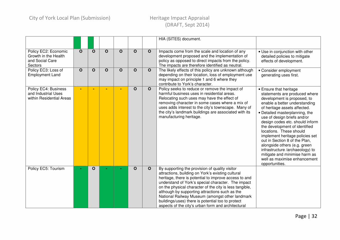
Policy EC2: Economic Growth in the Health and Social Care Sectors
O O O O O O Impacts come from the scale and location of any development proposed and the implementation of policy as opposed to direct impacts from the policy. The impacts are therefore identified as neutral.
• Use in conjunction with other detailed policies to mitigate effects of development.
Policy EC3: Loss of Employment Land
O O O O O O The likely effects of this policy are unknown although depending on their location, loss of employment use may impact on principle 1 and 6 where they contribute to York’s character.
• Consider employment generating uses first.
Policy EC4: Business and Industrial Uses within Residential Areas
- - - - O O Policy seeks to reduce or remove the impact of harmful business uses in residential areas. Relocating such uses may have the effect of removing character in some cases where a mix of uses adds interest to the city’s townscape. Many of the city’s landmark buildings are associated with its manufacturing heritage.
• Ensure that heritage statements are produced where development is proposed, to enable a better understanding of heritage assets affected.
• Detailed masterplanning, the use of design briefs and/or design codes etc. should inform the development of identified locations. These should implement heritage policies set out in Section 8 of the Plan, alongside others (e.g. green infrastructure /archaeology) to mitigate and minimise harm as well as maximise enhancement opportunities.
Policy EC5: Tourism - O - - O O By supporting the provision of quality visitor attractions, building on York’s existing cultural heritage, there is potential to improve access to and understand of York’s special character. The impact on the physical character of the city is less tangible, although by supporting attractions such as the National Railway Museum (amongst other landmark buildings/uses) there is potential too to protect aspects of the city’s urban form and architectural

City of York Local Plan (Submission) Heritage Impact Appraisal
(DRAFT, Sept 2014)
Page | 33
character. Other historic buildings may be given longevity through new creative uses.
Policy EC6: Rural Economy
O O O O O ?O See also EC1. Impacts come from the scale and location of any development proposed and the implementation of policy as opposed to direct impacts from the policy. The impacts are therefore identified as neutral.
• Ensure that heritage statements are produced where development is proposed, to enable a better understanding of heritage assets affected.
• Detailed masterplanning, the use of design briefs and/or design codes etc. should inform the development of identified locations. These should implement heritage policies set out in Section 8 of the Plan, alongside others (e.g. green infrastructure /archaeology) to mitigate and minimise harm as well as maximise enhancement opportunities.
Policy R1: Retail Hierarchy and Sequential Approach
+ ++ O + O O By continuing to focus growth on York City Centre, this policy further enhances the city’s compactness. The survival of small specialist retail establishments is a significant contributor to the quality of the York experience. Architecturally there is a close fit between this use and the layout and fabric of many surviving historic buildings. Importantly, this characteristic maintains the authenticity of historic form. Concentrating town centre uses within existing centres helps to maintain the city’s dense urban fabric and also helps urban villages retain their identity.
• Ensure that heritage statements are produced where development is proposed, to enable a better understanding of heritage assets affected.
• Detailed masterplanning, the use of design briefs and/or design codes etc. should inform the development of identified locations. These should implement heritage policies set out in Section 8 of the Plan, alongside others (e.g. green infrastructure /archaeology) to mitigate and minimise harm as well as maximise enhancement opportunities.

City of York Local Plan (Submission) Heritage Impact Appraisal
(DRAFT, Sept 2014)
Page | 34
Policy R2: District Centres, Local Centres and Neighbourhood Parades
+ ++ O + O O Policy R2 aims to manage the mix of uses within existing centres, protecting them from inappropriate development, and makes specific mention of the potential impact on the historic environment. The survival of small specialist retail establishments is a significant contributor to the quality of the York experience. Architecturally there is a close fit between this use and the layout and fabric of many surviving historic buildings. Importantly, this characteristic maintains the authenticity of historic form. Concentrating town centre uses within existing centres helps to maintain the city’s dense urban fabric and also helps urban villages and rural communities retain their identity.
• Ensure that heritage statements are produced where development is proposed, to enable a better understanding of heritage assets affected.
Policy R3: York City Centre Retail
+ ++ O + O O Policy R3 gives preference to locating town centre uses within York’s city centre. The survival of small specialist retail establishments is a significant contributor to the quality of the York experience. Architecturally there is a close fit between this use and the layout and fabric of many surviving historic buildings. Importantly, this characteristic maintains the authenticity of historic form. Concentrating town centre uses within existing centres helps to maintain the city’s dense urban fabric and also helps urban villages retain their identity. See also SS10: Castle Piccadilly Area of Opportunity.
• Ensure that heritage statements are produced where development is proposed, to enable a better understanding of heritage assets affected.
• Detailed masterplanning, the use of design briefs and/or design codes etc. should inform the development of identified locations. These should implement heritage policies set out in Section 8 of the Plan, alongside others (e.g. green infrastructure /archaeology) to mitigate and minimise harm as well as maximise enhancement opportunities.
Policy R4: Out of Centre Retailing
+ ++ O + O - Policy R4 gives preference to existing centres, making reference to the sequential test set out in R1. Concentrating town centre uses within existing centres helps to maintain the city’s dense urban fabric and also helps urban villages and rural communities retain their identity.
• Ensure that heritage statements are produced where development is proposed, to enable a better understanding of heritage assets affected.

City of York Local Plan (Submission) Heritage Impact Appraisal
(DRAFT, Sept 2014)
Page | 35
There is potential for harm to historic character and, particularly, the setting of the city through the development of unidentified out-of-centre retail locations. The open countryside and green belt supports a wide variety of different habitats and landscape elements, alongside affording long distance views, recreation routes and contributing to the setting of villages.
Section 5: Housing
Policy H1: Housing Allocations
? + ? + ? ? ? ? H1 is a housing allocations policy, determining a list and phasing of housing sites to provide for housing need across the plan period. Refer to Strategic Sites above or HIA (SITES) document (where relevant) for full HIA appraisal. In general, the principle of allocating sites to accommodate housing need, rather than responding to speculative planning applications, has the potential to manage the wider impact of development and to positively plan for how it can help to deliver social/cultural benefits through education or improved access to heritage assets, eg through CIL.
• Identify and incorporate views and reveal new views within proposed development design.
• Detailed masterplanning, the use of design briefs and/or design codes etc. should inform the development of identified locations. These should implement heritage policies set out in Section 8 of the Plan, alongside others (e.g. green infrastructure /archaeology) to mitigate and minimise harm as well as maximise enhancement opportunities.
Policy H2: Density of Residential Development
O + O + O O + O O H2 takes a zoned approach to development density, supporting higher densities within 400m of a higher frequency public transport corridor. The policy also recognises that development should respond to its context and local character. This principle has the potential to reinforce the city’s compactness, reinforcing connectivity and strengthen the mix of uses within the urban core – this will be reliant on sensitive design to deliver scale and massing appropriate to individual sites. As such, impact on other historic characteristics will be dependent on the
• Ensure that heritage statements are produced where development is proposed, to enable a better understanding of heritage assets affected.
• Detailed masterplanning, the use of design briefs and/or design codes etc. should inform the development of identified locations. These should implement heritage policies set
City of York Local Plan (Submission) Heritage Impact Appraisal
(DRAFT, Sept 2014)
Page | 36
nature of development and its implementation. out in Section 8 of the Plan, alongside others (e.g. green infrastructure /archaeology) to mitigate and minimise harm as well as maximise enhancement opportunities.
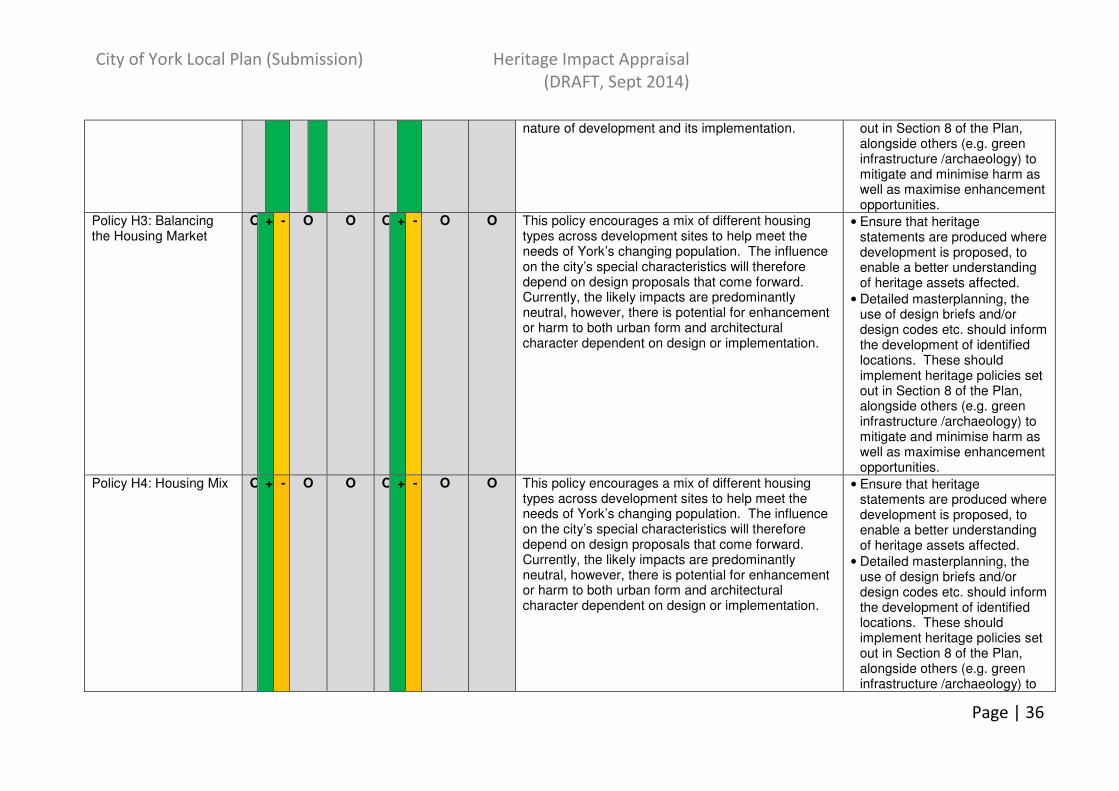
Policy H3: Balancing the Housing Market
O + - O O O + - O O This policy encourages a mix of different housing types across development sites to help meet the needs of York’s changing population. The influence on the city’s special characteristics will therefore depend on design proposals that come forward. Currently, the likely impacts are predominantly neutral, however, there is potential for enhancement or harm to both urban form and architectural character dependent on design or implementation.
• Ensure that heritage statements are produced where development is proposed, to enable a better understanding of heritage assets affected.
• Detailed masterplanning, the use of design briefs and/or design codes etc. should inform the development of identified locations. These should implement heritage policies set out in Section 8 of the Plan, alongside others (e.g. green infrastructure /archaeology) to mitigate and minimise harm as well as maximise enhancement opportunities.
Policy H4: Housing Mix O + - O O O + - O O This policy encourages a mix of different housing types across development sites to help meet the needs of York’s changing population. The influence on the city’s special characteristics will therefore depend on design proposals that come forward. Currently, the likely impacts are predominantly neutral, however, there is potential for enhancement or harm to both urban form and architectural character dependent on design or implementation.
• Ensure that heritage statements are produced where development is proposed, to enable a better understanding of heritage assets affected.
• Detailed masterplanning, the use of design briefs and/or design codes etc. should inform the development of identified locations. These should implement heritage policies set out in Section 8 of the Plan, alongside others (e.g. green infrastructure /archaeology) to

City of York Local Plan (Submission) Heritage Impact Appraisal
(DRAFT, Sept 2014)
Page | 37
mitigate and minimise harm as well as maximise enhancement opportunities.
Policy H5: Promoting Self-build
O O O O O O H5 seeks to promote self build, requiring a proportion of the largest strategic sites to be given over to small house builders. This is unlikely to have a direct impact on historic character.
• Detailed masterplanning, the use of design briefs and/or design codes etc. should inform the development of identified locations. These should implement heritage policies set out in Section 8 of the Plan, alongside others (e.g. green infrastructure /archaeology) to mitigate and minimise harm as well as maximise enhancement opportunities.
Policy H6: Gypsy, Traveller and Showpeople Allocations
O O O O O - H5 gives protection to existing sites/plots, identifies likely need for additional sites/plots over the plan period and sets out a number of allocated sites to provide for some of that need. Criteria are also included to guide site appraisal – these include the clause to conserve and enhance York’s historic character. The likely effects are predominantly likely to be neutral for this policy. However, it has been identified that there is the potential for minor harm to Characteristic 6: Landscape and Setting in relation to the openness and purpose of the greenbelt, should sites within this be considered for this use. The type and scale of these would be dependent upon the location of sites.
• There is the potential to mitigate against harm to the landscape and setting of the city through the identification of suitable locations, in particular by avoiding those areas identified as Green Belt Character Areas. Need to ensure that landscape policy is implemented alongside this policy to mitigate any harmful impacts.
Policy H7: Student Housing
O O - O O - Potential harm has been identified for characteristics 3 and 6, Landmark Monuments and Landscape and Setting respectively, particularly in relation to the provision of n housing development at the University of York’s location on the green belt periphery (note: see also ED1, which asks that future provision of student accommodation on this site should take place within the campus).. The type and scale of
• Detailed masterplanning, the use of design briefs and/or design codes etc. should inform the development of identified locations. These should implement heritage policies set out in Section 8 of the Plan, alongside others (e.g. green
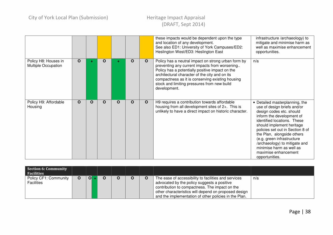
City of York Local Plan (Submission) Heritage Impact Appraisal
(DRAFT, Sept 2014)
Page | 38
these impacts would be dependent upon the type and location of any development. See also ED1: University of York Campuses/ED2: Heslington West/ED3: Heslington East
infrastructure /archaeology) to mitigate and minimise harm as well as maximise enhancement opportunities.
Policy H8: Houses in Multiple Occupation
O + O + O O Policy has a neutral impact on strong urban form by preventing any current impacts from worsening.. Policy has a potentially positive impact on the architectural character of the city and on its compactness as it is conserving existing housing stock and limiting pressures from new build development.
n/a
Policy H9: Affordable Housing
O O O O O O H9 requires a contribution towards affordable housing from all development sites of 2+. This is unlikely to have a direct impact on historic character.
• Detailed masterplanning, the use of design briefs and/or design codes etc. should inform the development of identified locations. These should implement heritage policies set out in Section 8 of the Plan, alongside others (e.g. green infrastructure /archaeology) to mitigate and minimise harm as well as maximise enhancement opportunities.
Section 6: Community
Facilities
Policy CF1: Community Facilities
O O + O O O O The ease of accessibility to facilities and services advocated by the policy suggests a positive contribution to compactness. The impact on the other characteristics will depend on proposed design and the implementation of other policies in the Plan.
n/a

City of York Local Plan (Submission) Heritage Impact Appraisal
(DRAFT, Sept 2014)
Page | 39
Policy CF2: Built Sports Facilities
O O + O O O O This policy suggests a possible positive impact on compactness given that facilities need to be located in accessible locations, although the impacts depend on the knock on effect/locations of new facilities, if provided.
n/a
Policy CF3: Childcare Provision
O O O O O o This policy is likely to have neutral impact on the 6 principal characteristics.
n/a
Policy CF4:Healthcare and Emergency Services
- + + - O - O - The provision of new services to accommodate additional need generated by strategic housing allocations puts an additional demand on development land. There are limited locations for these facilities and therefore it may encourage densification of existing locations. Policy notes that the setting of important historic buildings should be protected, but the level of impact on strong urban form and character and setting depends on the scale and design of any new or expanding facility. In order to mitigate this, it will be important to implement other policies in the plan in relation to design and landscaping. This policy is likely to have a positive impact on compactness as this policy will minimise urban sprawl. There is the potential for any new buildings in connection to this policy to contribute or cause potential for harm to the architectural legacy of the city depending on the design and location of development. Given the location of existing sites, there may be some sensitivity to existing high profile/designated buildings. Potential harm has been identified to sites from disturbance during and as a consequence to expansion of services.
• Implementation of other policies in the plan (e.g. relating to design) will be necessary to any proposed expansion/new facility to minimise harm to urban form/character and setting.
• Ensure that heritage statements are produced where development is proposed, to enable a better understanding of heritage assets affected.
Section 7: Education
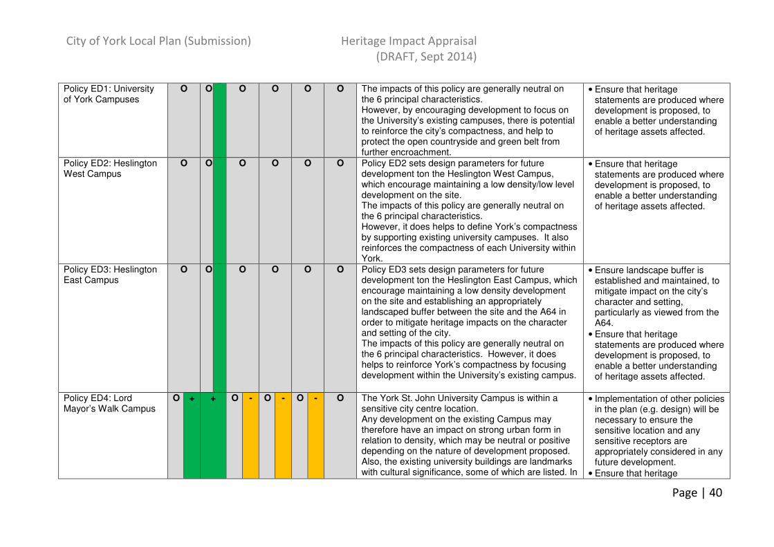
City of York Local Plan (Submission) Heritage Impact Appraisal
(DRAFT, Sept 2014)
Page | 40
Policy ED1: University of York Campuses
O O O O O O The impacts of this policy are generally neutral on the 6 principal characteristics. However, by encouraging development to focus on the University’s existing campuses, there is potential to reinforce the city’s compactness, and help to protect the open countryside and green belt from further encroachment.
• Ensure that heritage statements are produced where development is proposed, to enable a better understanding of heritage assets affected.
Policy ED2: Heslington West Campus
O O O O O O Policy ED2 sets design parameters for future development ton the Heslington West Campus, which encourage maintaining a low density/low level development on the site. The impacts of this policy are generally neutral on the 6 principal characteristics. However, it does helps to define York’s compactness by supporting existing university campuses. It also reinforces the compactness of each University within York.
• Ensure that heritage statements are produced where development is proposed, to enable a better understanding of heritage assets affected.
Policy ED3: Heslington East Campus
O O O O O O Policy ED3 sets design parameters for future development ton the Heslington East Campus, which encourage maintaining a low density development on the site and establishing an appropriately landscaped buffer between the site and the A64 in order to mitigate heritage impacts on the character and setting of the city. The impacts of this policy are generally neutral on the 6 principal characteristics. However, it does helps to reinforce York’s compactness by focusing development within the University’s existing campus.
• Ensure landscape buffer is established and maintained, to mitigate impact on the city’s character and setting, particularly as viewed from the A64.
• Ensure that heritage statements are produced where development is proposed, to enable a better understanding of heritage assets affected.
Policy ED4: Lord Mayor’s Walk Campus
O + + O - O - O - O The York St. John University Campus is within a sensitive city centre location. Any development on the existing Campus may therefore have an impact on strong urban form in relation to density, which may be neutral or positive depending on the nature of development proposed. Also, the existing university buildings are landmarks with cultural significance, some of which are listed. In
• Implementation of other policies in the plan (e.g. design) will be necessary to ensure the sensitive location and any sensitive receptors are appropriately considered in any future development.
• Ensure that heritage
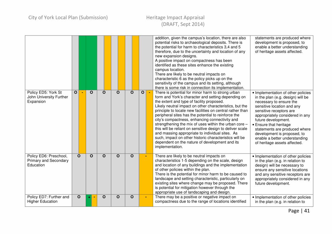
City of York Local Plan (Submission) Heritage Impact Appraisal
(DRAFT, Sept 2014)
Page | 41
addition, given the campus’s location, there are also potential risks to archaeological deposits. There is the potential for harm to characteristics 3,4 and 5 therefore, due to the uncertainty and location of any new expansion designs. A positive impact on compactness has been identified as these sites enhance the existing campus location. There are likely to be neutral impacts on characteristic 6 as the policy picks up on the sensitivity of the campus and its setting, although there is some risk in connection its implementation.
statements are produced where development is proposed, to enable a better understanding of heritage assets affected.
Policy ED5: York St John University Further Expansion
O - O O O O O - There is potential for minor harm to strong urban form and York’s character and setting depending on the extent and type of facility proposed. Likely neutral impact on other characteristics, but the principle to locate new facilities on central rather than peripheral sites has the potential to reinforce the city’s compactness, enhancing connectivity and strengthening the mix of uses within the urban core – this will be reliant on sensitive design to deliver scale and massing appropriate to individual sites. As such, impact on other historic characteristics will be dependent on the nature of development and its implementation.
• Implementation of other policies in the plan (e.g. design) will be necessary to ensure the sensitive location and any sensitive receptors are appropriately considered in any future development.
• Ensure that heritage statements are produced where development is proposed, to enable a better understanding of heritage assets affected.
Policy ED6: Preschool, Primary and Secondary Education
O O O O O - There are likely to be neutral impacts on characteristics 1-5 depending on the scale, design and location of any buildings and the implementation of other policies within the plan. There is the potential for minor harm to be caused to landscape and setting characteristic, particularly on existing sites where change may be proposed. There is potential for mitigation however through the appropriate use of landscaping and design.
• Implementation of other policies in the plan (e.g. in relation to design) will be necessary to ensure any sensitive locations and any sensitive receptors are appropriately considered in any future development.
Policy ED7: Further and Higher Education
O + - O O O - There may be a positive or negative impact on compactness due to the range of locations identified
• Implementation of other policies in the plan (e.g. in relation to
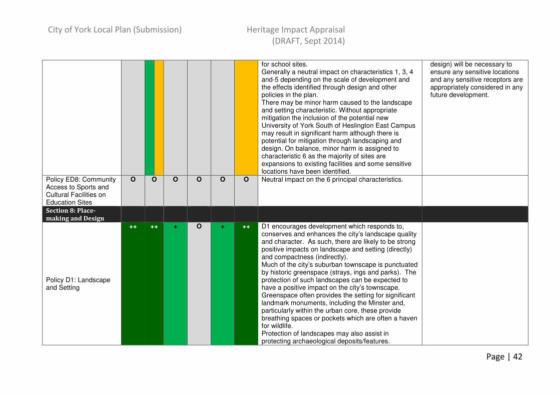
City of York Local Plan (Submission) Heritage Impact Appraisal
(DRAFT, Sept 2014)
Page | 42
for school sites. Generally a neutral impact on characteristics 1, 3, 4 and-5 depending on the scale of development and the effects identified through design and other policies in the plan. There may be minor harm caused to the landscape and setting characteristic. Without appropriate mitigation the inclusion of the potential new University of York South of Heslington East Campus may result in significant harm although there is potential for mitigation through landscaping and design. On balance, minor harm is assigned to characteristic 6 as the majority of sites are expansions to existing facilities and some sensitive locations have been identified.
design) will be necessary to ensure any sensitive locations and any sensitive receptors are appropriately considered in any future development.
Policy ED8: Community Access to Sports and Cultural Facilities on Education Sites
O O O O O O Neutral impact on the 6 principal characteristics.
Section 8: Place-
making and Design
Policy D1: Landscape and Setting
++ ++ + O + ++ D1 encourages development which responds to, conserves and enhances the city’s landscape quality and character. As such, there are likely to be strong positive impacts on landscape and setting (directly) and compactness (indirectly). Much of the city’s suburban townscape is punctuated by historic greenspace (strays, ings and parks). The protection of such landscapes can be expected to have a positive impact on the city’s townscape. Greenspace often provides the setting for significant landmark monuments, including the Minster and, particularly within the urban core, these provide breathing spaces or pockets which are often a haven for wildlife. Protection of landscapes may also assist in protecting archaeological deposits/features.
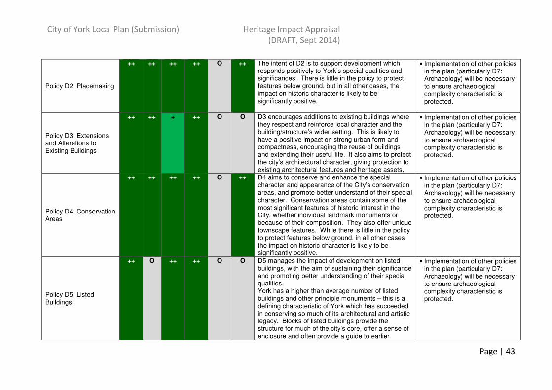
City of York Local Plan (Submission) Heritage Impact Appraisal
(DRAFT, Sept 2014)
Page | 43
Policy D2: Placemaking
++ ++ ++ ++ O ++ The intent of D2 is to support development which responds positively to York’s special qualities and significances. There is little in the policy to protect features below ground, but in all other cases, the impact on historic character is likely to be significantly positive.
• Implementation of other policies in the plan (particularly D7: Archaeology) will be necessary to ensure archaeological complexity characteristic is protected.
Policy D3: Extensions and Alterations to Existing Buildings
++ ++ + ++ O O D3 encourages additions to existing buildings where they respect and reinforce local character and the building/structure’s wider setting. This is likely to have a positive impact on strong urban form and compactness, encouraging the reuse of buildings and extending their useful life. It also aims to protect the city’s architectural character, giving protection to existing architectural features and heritage assets.
• Implementation of other policies in the plan (particularly D7: Archaeology) will be necessary to ensure archaeological complexity characteristic is protected.
Policy D4: Conservation Areas
++ ++ ++ ++ O ++ D4 aims to conserve and enhance the special character and appearance of the City’s conservation areas, and promote better understand of their special character. Conservation areas contain some of the most significant features of historic interest in the City, whether individual landmark monuments or because of their composition. They also offer unique townscape features. While there is little in the policy to protect features below ground, in all other cases the impact on historic character is likely to be significantly positive.
• Implementation of other policies in the plan (particularly D7: Archaeology) will be necessary to ensure archaeological complexity characteristic is protected.
Policy D5: Listed Buildings
++ O ++ ++ O O D5 manages the impact of development on listed buildings, with the aim of sustaining their significance and promoting better understanding of their special qualities. York has a higher than average number of listed buildings and other principle monuments – this is a defining characteristic of York which has succeeded in conserving so much of its architectural and artistic legacy. Blocks of listed buildings provide the structure for much of the city’s core, offer a sense of enclosure and often provide a guide to earlier
• Implementation of other policies in the plan (particularly D7: Archaeology) will be necessary to ensure archaeological complexity characteristic is protected.
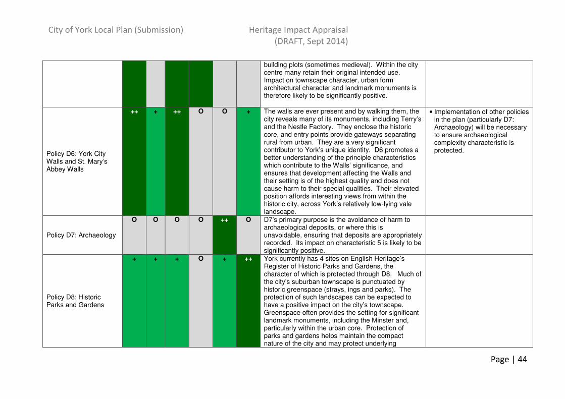
City of York Local Plan (Submission) Heritage Impact Appraisal
(DRAFT, Sept 2014)
Page | 44
building plots (sometimes medieval). Within the city centre many retain their original intended use. Impact on townscape character, urban form architectural character and landmark monuments is therefore likely to be significantly positive.
Policy D6: York City Walls and St. Mary’s Abbey Walls
++ + ++ O O + The walls are ever present and by walking them, the city reveals many of its monuments, including Terry’s and the Nestle Factory. They enclose the historic core, and entry points provide gateways separating rural from urban. They are a very significant contributor to York’s unique identity. D6 promotes a better understanding of the principle characteristics which contribute to the Walls’ significance, and ensures that development affecting the Walls and their setting is of the highest quality and does not cause harm to their special qualities. Their elevated position affords interesting views from within the historic city, across York’s relatively low-lying vale landscape.
• Implementation of other policies in the plan (particularly D7: Archaeology) will be necessary to ensure archaeological complexity characteristic is protected.
Policy D7: Archaeology
O O O O ++ O D7’s primary purpose is the avoidance of harm to archaeological deposits, or where this is unavoidable, ensuring that deposits are appropriately recorded. Its impact on characteristic 5 is likely to be significantly positive.
Policy D8: Historic Parks and Gardens
+ + + O + ++ York currently has 4 sites on English Heritage’s Register of Historic Parks and Gardens, the character of which is protected through D8. Much of the city’s suburban townscape is punctuated by historic greenspace (strays, ings and parks). The protection of such landscapes can be expected to have a positive impact on the city’s townscape. Greenspace often provides the setting for significant landmark monuments, including the Minster and, particularly within the urban core. Protection of parks and gardens helps maintain the compact nature of the city and may protect underlying

City of York Local Plan (Submission) Heritage Impact Appraisal
(DRAFT, Sept 2014)
Page | 45
archaeological deposits from disturbance.
Policy D9: City of York Historic Environment Record
++ ++ ++ ++ ++ +++ HER can provide information on significance and value of landmarks and lesser known monuments. HER can provide information on previous archaeological interventions to inform on the archaeological impact of development proposals. An element of protection to landscape and setting may be afforded through the development of the HER through the provision of information on significance/value of landscapes covered in grey literature. In general, maintaining and developing the HER ensures that development proposals are developed and appraised within the context of the most up date and comprehensive understanding of the City’s special characteristics. It also provides a facility from which further interpretation and education can be distilled.
Policy D10: The Significance of Non-Designated Heritage Assets
+ O ++ ++ ++ ++ In a similar vein to D5: Listed Buildings, D10 promotes the aim of sustaining the significance and better understanding of the special qualities of non-designated assets. Such assets can be important landmark monuments, and offer contextual historic eferences within a streetscene/neighbourhood. Policy recognises the range of significances such assets may hold. As a result, their protection is likely to have significantly positive impacts on may of the city’s special characteristics.
Policy D11: Shopfronts
++ O O ++ O O This policy is aimed at managing change to all shopfronts, not only those within historic buildings. There is balance between the design of an original shopfront ( fascia, stallriser and shop window) and its host building. Incremental change can offset this balance, dramatically changing the character of an individual building and the wider streetscene. By managing change, the impacts on architectural
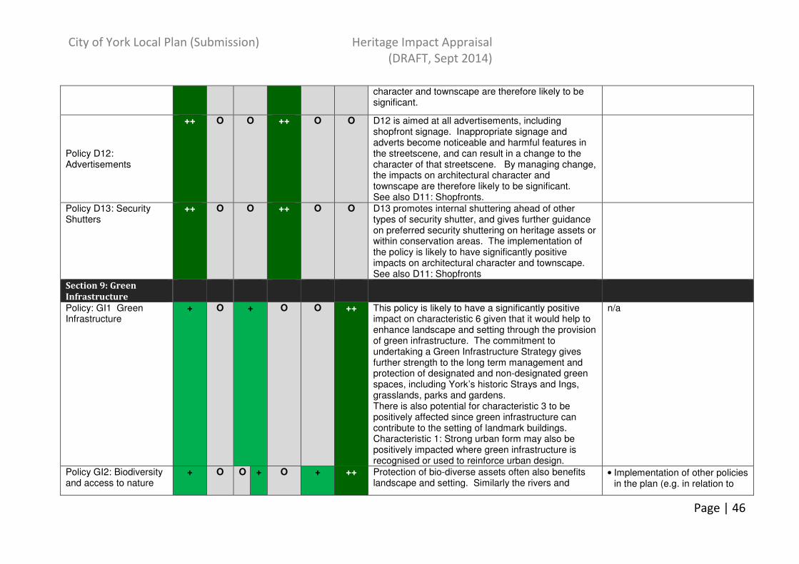
City of York Local Plan (Submission) Heritage Impact Appraisal
(DRAFT, Sept 2014)
Page | 46
character and townscape are therefore likely to be significant.
Policy D12: Advertisements
++ O O ++ O O D12 is aimed at all advertisements, including shopfront signage. Inappropriate signage and adverts become noticeable and harmful features in the streetscene, and can result in a change to the character of that streetscene. By managing change, the impacts on architectural character and townscape are therefore likely to be significant. See also D11: Shopfronts.
Policy D13: Security Shutters
++ O O ++ O O D13 promotes internal shuttering ahead of other types of security shutter, and gives further guidance on preferred security shuttering on heritage assets or within conservation areas. The implementation of the policy is likely to have significantly positive impacts on architectural character and townscape. See also D11: Shopfronts
Section 9: Green
Infrastructure
Policy: GI1 Green Infrastructure
+ O + O O ++ This policy is likely to have a significantly positive impact on characteristic 6 given that it would help to enhance landscape and setting through the provision of green infrastructure. The commitment to undertaking a Green Infrastructure Strategy gives further strength to the long term management and protection of designated and non-designated green spaces, including York’s historic Strays and Ings, grasslands, parks and gardens. There is also potential for characteristic 3 to be positively affected since green infrastructure can contribute to the setting of landmark buildings. Characteristic 1: Strong urban form may also be positively impacted where green infrastructure is recognised or used to reinforce urban design.
n/a
Policy GI2: Biodiversity and access to nature
+ O O + O + ++ Protection of bio-diverse assets often also benefits landscape and setting. Similarly the rivers and
• Implementation of other policies in the plan (e.g. in relation to

City of York Local Plan (Submission) Heritage Impact Appraisal
(DRAFT, Sept 2014)
Page | 47
strays are integral to York’s urban form. This policy has therefore been recognised to potentially have a significantly positive impact on characteristic 6. Characteristic 1: Strong urban form may also be positively impacted where public access or biodiversity is recognised or used to reinforce urban design. This may also have similar effects on architectural character.
design) will be necessary to ensure any sensitive locations and any sensitive receptors are appropriately considered in any future development.
Policy GI3: Trees + O + O O ++ Trees have been recognised to have a positive influence on a number of the characteristics due to their potential positive contribution to setting of buildings and monuments. Policy includes specific aim to retain trees and hedges that make a significant contribution to the character of setting of a conservation area or listed buildings. Trees/woodlands are a key feature in, and influence on, the urban form.
n/a
Policy GI4: Green Infrastructure Network
O + O + O + O O ++ Green Corridors are a primary influence on the Plan’s spatial strategy, included as an area of constrain within which development would be inappropriate. As such, the Plan acknowledges that green corridors are a significant feature in affording the City its unique setting (including of landmark monuments). The impact on urban form is more difficult to predict – a positive impact would require the implementation of other supporting design policies. Retaining/creating local access to green infrastructure on residents’ doorstep also potentially contributes to compactness.
• Implementation of other policies in the plan (e.g. in relation to design) will be necessary to ensure any sensitive locations and any sensitive receptors are appropriately considered in any future development.
Policy GI5: Protection of open space
O + O + O O O + O - Influence on characteristics depends on development type and design of openspace. While the policy gives protection to existing open space, there is scope for its development where appropriate provision could be made elsewhere. It has been identified that there could be potential for harm to landscape and setting due to loss of openness where openspace may be lost to another use.
• Implementation of other policies in the plan (e.g. design) will be necessary to ensure the sensitive location and any sensitive receptors are appropriately considered in any future development.
• Ensure that heritage

City of York Local Plan (Submission) Heritage Impact Appraisal
(DRAFT, Sept 2014)
Page | 48
However, there may some potential benefit for archaeological deposits as safeguarding openspace may mean they are not disturbed.
statements are produced where development is proposed, to enable a better understanding of heritage assets affected – this should include the historic setting of the city.
Policy: GI6 New open space and recreation provision
O + O + O O O - + Policy requires all new residential development to contribute towards provision of on-site open space. Additionally, it identifies strategic greenspace, the function of which is to help to protect the historic character and setting of the City. The impact on landscape and setting therefore requires sensitive negotiation and masterplanning. There is potential to harm setting depending on nature of open space provision. Potential to contribute to overall compactness by way of availability of local facilities.
• Implementation of other policies in the plan (e.g. design) will be necessary to ensure the sensitive location and any sensitive receptors are appropriately considered in any future development.
• Ensure that heritage statements are produced where development is proposed, to enable a better understanding of heritage assets affected – this should include the historic setting of the city.
Section 10: Managing
Development in the
Greenbelt
Policy GB1: Development in the Green Belt
+ ++ + O O ++ The City’s green belt is a key contributor to protecting the historic setting of the City, maintaining a compact centre and preserving the distinction between the city itself and its outlying villages. By protecting green belt land from development this policy should have significant positive impacts on both characteristic 2: Compactness and 6: Landscape and Setting. Ensuring development in the green belt would not harm the special characteristics of the city would potentially have a positive impact on its landmark
• Policy states that planning permission should only be granted where it wouldn’t harm the special characteristics of York.
• Implementation of other policies in the plan (e.g. design) will be necessary to ensure the sensitive location and any sensitive receptors are appropriately considered in any future development.

City of York Local Plan (Submission) Heritage Impact Appraisal
(DRAFT, Sept 2014)
Page | 49
monuments, such as the Minster – there is a unique contribution of cultural/historic significance important for the setting of York. Positive impacts are also identified for strong urban form as respecting the green belt boundary may help to reinforce existing settlements, encouraging the reuse of existing buildings rather than promoting village expansion.
• Ensure that heritage statements are produced where development is proposed, to enable a better understanding of heritage assets affected – this should include the historic setting of the city.
Policy GB2: Development in Settlements ‘Washed Over’ by the Greenbelt
+ + O O + + GB2 controls the type of development appropriate within ‘washed over’ villages – these are protected in recognition of their important contribution to the openness of the green belt. This policy is likely to have positive impacts on characteristics 1, 2 and 6 as it intends to protect strong urban form and promote compactness through only allowing small scale development contained within the built-up area. This should also have a positive impact on landscape and setting as it should also help to retain strong settlement boundaries and the distinction between outlying settlements and the urban edge. Further, by protecting the green belt from further development, archaeological deposits are likely to remain undisturbed.
n/a
Policy GB3: Reuse of buildings
O + O O + + GB3 encourages re-use rather than new build within green belt locations. This policy predominantly has positive impacts associated with the historic environment. The most apparent impact is likely to be in relation to the city’s landscape and setting. By managing the scale of development appropriate in sensitive green belt locations it is possible to protect the green belts openness, As with GB2 above this policy is likely to have positive impacts on characteristics 2 and 6 as it intends to protect strong urban form and promote compactness through only allowing small scale development contained within the built-up area. This should also have a positive
n/a

City of York Local Plan (Submission) Heritage Impact Appraisal
(DRAFT, Sept 2014)
Page | 50
impact on landscape and setting as it should also help to retain strong settlement boundaries and the distinction between outlying settlements and the urban edge. Further, by protecting the green belt from further development, archaeological features above and below ground are likely to remain undisturbed.
Policy GB4: Exception Sites for Affordable Housing in the Green Belt
+ - + - O + - O + - The impacts from this policy could be positive or cause minor harm depending upon implementation of policies in the plan as well as the location and design of a proposal.
• Implementation of other policies in the plan (e.g. design) will be necessary to ensure the sensitive location and any sensitive receptors are appropriately considered in any future development.
• Ensure that heritage statements are produced where development is proposed, to enable a better understanding of heritage assets affected.
Section 11: Managing
Climate Change
Policy CC1: Renewable and Low Carbon Energy Generation
O O O O - O O - This policy will have mostly neutral impacts on the principal characteristics given that adverse visual impacts on historic/settings landscapes are to be managed through the development process. Any potential harm to landscape and setting should be managed through the development process.
• The policy refers to considering impact on historic character/setting or diverse landscapes. Implementation of other policies in the plan (e.g. design) will be necessary to ensure the sensitive location and any sensitive receptors are appropriately considered in any future development.
• Ensure that heritage statements are produced where development is proposed, to enable a better understanding of heritage assets affected – this should include the historic

City of York Local Plan (Submission) Heritage Impact Appraisal
(DRAFT, Sept 2014)
Page | 51
setting of the city.
Policy CC2: Sustainable Design and Construction
O O O O - O O - Policy requires that all new development, including conversions, considers sustainable design principles. It will be important to ensure that proposals give careful consideration to their setting as such low/carbon/renewable energy generators could impact negatively on the city’s historic environment, particularly on its architectural character.
• Any policy or mitigation proposed to protect architectural complexity should be considered in conjunction with other relevant policies in the plan.
• Ensure that heritage statements are produced where development is proposed, to enable a better understanding of heritage assets affected.
Section 12:
Environmental Quality
and Protection
Policy ENV1: Air Quality O O + + + + This policy will have a generally neutral impact on principal characteristics 1 and 2. However, an indirect positive impact may be made to characteristics 3-6 through any improvements to air quality and the implementation of low emissions infrastructure.
n/a
Policy ENV2: Managing Environmental Quality
O O O O O O EQ2 manages the impact of development on its surroundings, and includes a clause to protect local character and distinctiveness from unwanted environmental impacts. This policy will therefore have mostly neutral impacts on the principal characteristics.
• The policy references minimising harm to local character and distinctiveness. Any policy or mitigation proposed should be considered in conjunction with other relevant policies in the plan
Policy ENV3: Land Contamination
O O O O - O A generally neutral impact on strong urban form and architectural character has been identified but there is the potential for change to the grain of street depending on the location of any remediation. Predominantly a neutral impact on characteristics 2, 3 & 6, although this is largely dependent upon location and remediation methods.
• Any policy or mitigation proposed should be considered in conjunction with other relevant policies in the plan (e.g in relation to design and conservation), particularly in relation to characteristics 2, 3, 5

City of York Local Plan (Submission) Heritage Impact Appraisal
(DRAFT, Sept 2014)
Page | 52
Minor harm may be caused to archaeological deposits due to remediation of land from contamination. There may be some benefits gained through remediation for understanding history of the site. However, on balance, it is likely that there is more potential to be harmful by removal than the benefit gained through excavation and understanding.
and 6.
Policy ENV4: Flood Risk
O + - O O O + + - The Local Plan’s development strategy avoids land at greatest risk of flooding, and promotes sites which are within lower risk zones. This risk avoidance strategy has the effect of retaining historic development patterns. Flood risk has helped to constrain the development of York and provide a compact city with accessible green space. Development on sites with higher flood risk may have an impact on this and there are uncertainties over what mitigation measures could be implemented. Impact would depend on measures required. Generally a neutral impact on characteristic 5 although there is the potential for a positive impact here by maintaining flood risk to land which may protect waterlogged archaeological deposits. Flood risk has helped to provide the city with accessible green space. Development on sites with higher flood risk may have an impact on this. However, there are uncertainties over what mitigation measures could be implemented. Impact would depend on measures required.
• Mitigation in relation to characteristics 2 & 6. Mitigation measures would need to be considered against other policies in the Plan to ensure adverse impacts are avoided.
Policy ENV5: Sustainable Drainage
O + - O O O + -
Overall, surface water management is likely to have a neutral impact on HE characteristic. There is potential for a positive impact on archaeological complexity by maintaining flood risk to land which may protect waterlogged archaeological deposits. Water management has helped to provide the city with accessible green space. Development on sites
2 & 6. Mitigation measures would need to be considered against other policies to ensure adverse impacts are avoided.

City of York Local Plan (Submission) Heritage Impact Appraisal
(DRAFT, Sept 2014)
Page | 53
with higher flood risk may have an impact on this. However, there are uncertainties over what mitigation measures could be implemented. Impact would depend on measures required.
Section 13: Waste and
Minerals
Policy WM1: Sustainable Waste Management
O O O O O O
Neutral impacts have been identified on the 6 principal characteristics. The policy contains constraints for ensuring no significant adverse effects occur to the historic environment through waste management.
• Ensure that any specific locations for waste management are dealt with in accordance with other policies within the plan and the emerging Minerals and Waste Plan, where applicable.
Policy WM2: Sustainable Minerals Management
O O O O O O + General neutral impact on the 6 principal characteristics given that the policy would only permit minerals development where York’s heritage and environmental assets are conserved and enhanced. In the long-term, there may be a positive impact as a result of mitigation following any development that has occurred.
• Ensure that any specific locations for minerals management are dealt with in accordance with other policies within the plan and the emerging Minerals and Waste Plan, where applicable.
Section 14:
Infrastructure
Policy T1: Sustainable Access
+ - + O O O O - T1 aims to locate high trip generating development in locations where access to frequent high quality public transport links are available, and that provision is made to promote sustainable modes of travel. It does not make reference to the need for impact on character to be appraised, and as such should be mitigated by the implementation of other supporting design policies. There is potential that promoting accessible sites could be to the detriment of the city’s compactness and setting, as peripheral sites along high frequency transport corridors could be promoted. Conversely, by promoting higher density development along primary corridors there could be a positive impact in terms of the city’s urban form and compactness, maintaining and reinforcing those
• Implementation of other policies in the plan (e.g. design) will be necessary to ensure the sensitive location and any sensitive receptors are appropriately considered in any future development.
• Ensure that heritage statements are produced where development is proposed, to enable a better understanding of heritage assets affected – this should include the historic setting of the city.

City of York Local Plan (Submission) Heritage Impact Appraisal
(DRAFT, Sept 2014)
Page | 54
strong arterial roads which follow historic routes.
Policy T2: Strategic Public Transport Improvements
- + O O O O O T2 As with T1 above, T2 makes no reference to the need to consider the design implications of development proposed, and should be mitigated by other supporting policies. Changes to bus lanes or access points could impact on the cobbled margins and tree lined avenues which run alongside the city’s arterial routes. The provision of larger facilities, including new railway stations, is likely to impact on townscape, but the nature of that impact is unknown until sites and masterplans have been established. Some may have the positive impact of reducing transport movements on currently congested arterial routes.
• Implementation of other policies in the plan (e.g. design) will be necessary to ensure the sensitive location and any sensitive receptors are appropriately considered in any future development.
Policy T3: York Railway Station and Associated Operational Facilities
+ O ++ ++ O O Proposals that enhance the Grade II* station and its setting that conserve and enhance its historic environment, particularly those that improve the visual amenity at the station and its environs, are likely to result in significant positive impacts on the stations architectural character. Further, as one of York’s diverse landmark monuments, the Station buildings add richness and interest to the City’s townscape.
• Ensure that any proposals refer to the relevant policies on design and Listed Buildings.
Policy T4: Strategic Highway Network Capacity Improvements
- + O O O O O T4 makes no reference to the need to consider the design implications of development proposed, and should be mitigated by other supporting policies. Changes to the transport network could impact on the cobbled margins and tree lined avenues which run alongside the city’s arterial routes. By increasing capacity on some routes there may be the knock on effect of reducing transport movements on other currently congested arterial routes.
Policy T5: Strategic Cycle and Pedestrian Network Links and Improvements
O - O O O O O As with T1 above, T5 makes no reference to the need to consider the design implications of development proposed, and should be mitigated by other supporting policies. Changes to existing cycle
• Implementation of other policies in the plan (e.g. design) will be necessary to ensure the sensitive location and any

City of York Local Plan (Submission) Heritage Impact Appraisal
(DRAFT, Sept 2014)
Page | 55
lanes or new provision could impact on the cobbled margins and tree lined avenues which run alongside the city’s arterial routes.
sensitive receptors are appropriately considered in any future development.
Policy T6: Development at or Near Public Transport Corridors, Interchanges and Facilities
O O O O O O T6 protects unused land which has been identified as having viable future transport development potential. The policy promotes higher density development in the vicinity of well served interchanges, but notes that this should not have an adverse impact on the character, historic environment and amenity of the area – this should be established through pre-application appraisal work, and any application informed by a supporting heritage appraisal.
• Implementation of other policies in the plan (e.g. design) will be necessary to ensure the sensitive location and any sensitive receptors are appropriately considered in any future development.
• Ensure that heritage statements are produced where development is proposed, to enable a better understanding of heritage assets affected – this should include the historic setting of the city.
Policy T7: Demand Management
O - O O O O O T7 promotes changes to existing carriageways as one means of improving the overall flow of traffic in and around York city centre. Changes to existing routes could impact on the cobbled margins and tree lined avenues which run alongside the city’s arterial routes.
• Implementation of other policies in the plan (e.g. design) will be necessary to ensure the sensitive location and any sensitive receptors are appropriately considered in any future development.
Policy T8: Minimising and Accommodating Generated Trips
O O O O O O T8 focuses on the information to be included within a transport statement. No likely impacts identified.
Policy T9: Freight Consolidation
O O O O O O - The location of future freight consolidation is likely to be within the city’s green belt, as is the proposed site near Askham Bryan. Such sites have the potential to negatively impact on the openness of the green belt, providing new features within otherwise rural settings. It will be important for such proposals to consider their impact on view corridors, the city’s natural/rural character, the setting of villages and on
• Ensure that heritage statements are produced where development is proposed, to enable a better understanding of heritage assets affected – this should include the historic setting of the city.

City of York Local Plan (Submission) Heritage Impact Appraisal
(DRAFT, Sept 2014)
Page | 56
other habitats and landscapes which afford the city its setting.
Policy T10: Safeguarded Routes and Sites
O - O O O O O As with preceding transport policies, there is potential that changes to the existing road network could result in the loss of features (street trees, cobbled margins) which add to the city centre’s character. The impact from other development sites should be mitigated through pre-application appraisal work, and any application informed by a supporting heritage appraisal.
• Ensure that heritage statements are produced where development is proposed, to enable a better understanding of heritage assets affected – this should include the historic setting of the city.
Policy C1: Communications Infrastructure
O - O O O - O O - This policy will have mostly neutral impacts on the principal characteristics given that adverse visual impacts and impacts on sensitive green belt or other historic landscape areas, are to be managed through the development process. Further, the policy promotes rationalising street ‘clutter’ where facilities are no longer operational.
• The policy refers to considering impact on historic character/setting or diverse landscapes. Implementation of other policies in the plan (e.g. design) will be necessary to ensure the sensitive location and any sensitive receptors are appropriately considered in any future development.
Section 15: Delivery and Monitoring
Policy DM1: Infrastructure and Developer Contributions
+ + + + + + C1 allows for contributions to be sought for infrastructure provision, including for public realm improvements and the protection and improvement of the historic environment, which can include improved interpretation. As such, C1 is likely to have generally positive impacts on the city’s special characteristics.
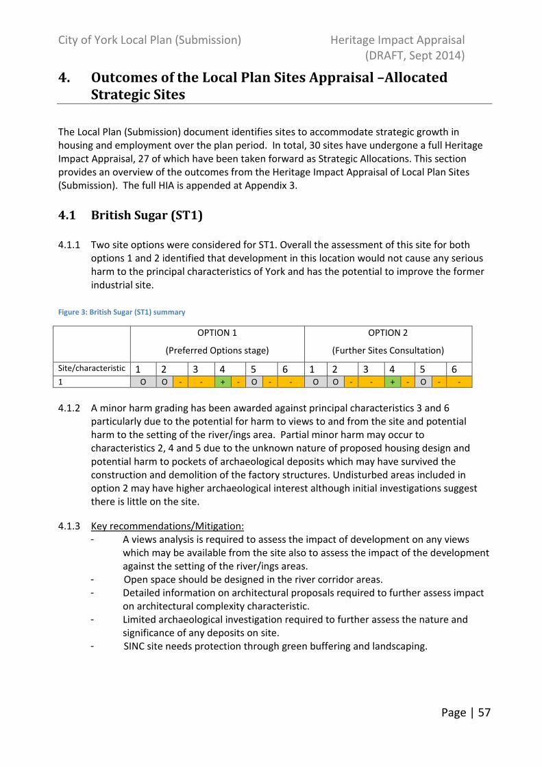
City of York Local Plan (Submission) Heritage Impact Appraisal
(DRAFT, Sept 2014)
Page | 57
4. Outcomes of the Local Plan Sites Appraisal –Allocated
Strategic Sites
The Local Plan (Submission) document identifies sites to accommodate strategic growth in
housing and employment over the plan period. In total, 30 sites have undergone a full Heritage
Impact Appraisal, 27 of which have been taken forward as Strategic Allocations. This section
provides an overview of the outcomes from the Heritage Impact Appraisal of Local Plan Sites
(Submission). The full HIA is appended at Appendix 3.
4.1 British Sugar (ST1)
4.1.1 Two site options were considered for ST1. Overall the assessment of this site for both
options 1 and 2 identified that development in this location would not cause any serious
harm to the principal characteristics of York and has the potential to improve the former
industrial site.
Figure 3: British Sugar (ST1) summary
OPTION 1
(Preferred Options stage)
OPTION 2
(Further Sites Consultation)
Site/characteristic 1 2 3 4 5 6 1 2 3 4 5 6 1 O O - - + - O - - O O - - + - O - -
4.1.2 A minor harm grading has been awarded against principal characteristics 3 and 6
particularly due to the potential for harm to views to and from the site and potential
harm to the setting of the river/ings area. Partial minor harm may occur to
characteristics 2, 4 and 5 due to the unknown nature of proposed housing design and
potential harm to pockets of archaeological deposits which may have survived the
construction and demolition of the factory structures. Undisturbed areas included in
option 2 may have higher archaeological interest although initial investigations suggest
there is little on the site.
4.1.3 Key recommendations/Mitigation:
- A views analysis is required to assess the impact of development on any views
which may be available from the site also to assess the impact of the development
against the setting of the river/ings areas.
- Open space should be designed in the river corridor areas.
- Detailed information on architectural proposals required to further assess impact
on architectural complexity characteristic.
- Limited archaeological investigation required to further assess the nature and
significance of any deposits on site.
- SINC site needs protection through green buffering and landscaping.

City of York Local Plan (Submission) Heritage Impact Appraisal
(DRAFT, Sept 2014)
Page | 58
4.2 Former civil service sports ground (ST2)
4.2.1 Two options have been considered for ST2. Overall the assessment of both options
submitted for this site has identified that development in this location would not cause
any serious harm to the principal characteristics of York. Figure 4: Fmr Civil Service Sports Ground (ST2) summary
OPTION 1
(Preferred Options stage)
OPTION 2
(Further Sites Consultation)
Site/characteristic 1 2 3 4 5 6 1 2 3 4 5 6 2 O O - O - - - - O O - O - - - -
4.2.2 Partial minor harm may occur to principal characteristics 4 and 5 particularly due to the
unknown nature of proposed housing design and the potential for harm to any surviving
archaeological deposits or historic landscape features. The site does not significantly
contribute to the open countryside surrounding York, particularly since the re-location of
Manor School adjacent.
4.2.3 Key recommendations/Mitigation:
- A views analysis is required to assess the impact of development on any views
which may be available from the site also to further inform design proposals on
how the development may appear from nearby areas due to its slightly elevated
topography.
- Detailed information on architectural proposals required to further assess impact
on architectural complexity characteristic.
- Archaeological investigation required to further assess the nature and significance
of any archaeological deposits on site.
- Retention of the 18th
century field boundary should be sought if possible as not
many survive in this area.
4.3 The Grain Stores, Water Lane (ST3)
4.3.1 Only one option was considered for ST3. Overall the assessment of this site has identified
that development in this location would not cause any serious harm to the principal
characteristics of York.
Figure 5: The Grain Stores (ST3) summary
OPTION 1
(Preferred Options stage)
Site/characteristic 1 2 3 4 5 6 3 O O O - - O

City of York Local Plan (Submission) Heritage Impact Appraisal
(DRAFT, Sept 2014)
Page | 59
4.3.2 Potential minor harm has been identified against principal characteristics 4 and 5
particularly due to the unknown nature of proposed housing design and possibility of
harm to known surviving archaeological deposits primarily relating to the former airfield.
4.3.3 Key recommendations/Mitigation:
- Detailed information on architectural proposals required to further assess impact
on architectural complexity characteristic.
- Development on the border with Victoria Farm should be sympathetically
integrated to fit in with the immediate surroundings of the farm.
- -Further archaeological investigation may be required when proposals are known
to assess the impact on known archaeological deposits.
4.4 Land adjacent to Hull Road, Grimston Bar (ST4)
4.4.1 Only one option was considered for ST4. A summary of the impact of development in this
area on the principal characteristics of York is set out below.
Figure 6: Land adj Hull Road (ST4) summary
OPTION 1
(Preferred Options stage)
Site/characteristic 1 2 3 4 5 6 4 O O - - - -- -
4.4.2 The assessment of this site has identified that development in this location may
potentially result in serious harm to principal characteristic 5 regarding the archaeological
complexity of the site. A desk based assessment has confirmed that the site may contain
features relating to the prehistoric and Romano-British period. The threat to
archaeological deposits can be mitigated against through planning policy and guidance.
4.4.3 Minor harm may occur to principal characteristics 3, 4 and 6 (and partial minor harm to 2)
particularly due to the unknown nature of proposed housing design and its visibility
occupying an elevated position, the potential harm on views from the hillside and the loss
of a buffer between the university campus and residential areas. Kimberlow Hill currently
provides 360 degree views towards the historic core and The Minster and outwards
across the rural landscape of the Wolds and the Vale.
4.4.4 Key recommendations/Mitigation:
- Detailed information on architectural proposals required to further assess impact
on architectural complexity characteristic. Roofscape needs to be carefully designed
given the elevated position of the site.
- Develop site with low-medium density housing and small scale buildings due to the
topography of the area.
- Retain, frame and create new views of the Minster, rural area and cityscape
through the housing layout.
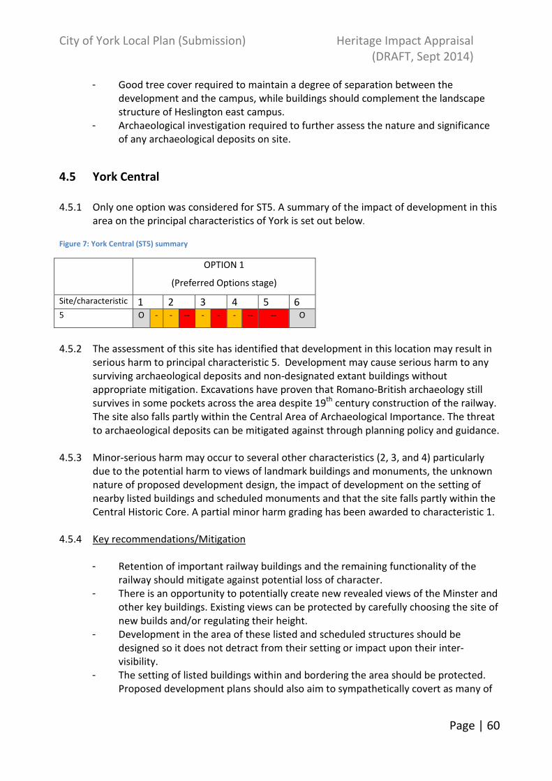
City of York Local Plan (Submission) Heritage Impact Appraisal
(DRAFT, Sept 2014)
Page | 60
- Good tree cover required to maintain a degree of separation between the
development and the campus, while buildings should complement the landscape
structure of Heslington east campus.
- Archaeological investigation required to further assess the nature and significance
of any archaeological deposits on site.
4.5 York Central
4.5.1 Only one option was considered for ST5. A summary of the impact of development in this
area on the principal characteristics of York is set out below.
Figure 7: York Central (ST5) summary
OPTION 1
(Preferred Options stage)
Site/characteristic 1 2 3 4 5 6 5 O - - -- - - - -- -- O
4.5.2 The assessment of this site has identified that development in this location may result in
serious harm to principal characteristic 5. Development may cause serious harm to any
surviving archaeological deposits and non-designated extant buildings without
appropriate mitigation. Excavations have proven that Romano-British archaeology still
survives in some pockets across the area despite 19th
century construction of the railway.
The site also falls partly within the Central Area of Archaeological Importance. The threat
to archaeological deposits can be mitigated against through planning policy and guidance.
4.5.3 Minor-serious harm may occur to several other characteristics (2, 3, and 4) particularly
due to the potential harm to views of landmark buildings and monuments, the unknown
nature of proposed development design, the impact of development on the setting of
nearby listed buildings and scheduled monuments and that the site falls partly within the
Central Historic Core. A partial minor harm grading has been awarded to characteristic 1.
4.5.4 Key recommendations/Mitigation
- Retention of important railway buildings and the remaining functionality of the
railway should mitigate against potential loss of character.
- There is an opportunity to potentially create new revealed views of the Minster and
other key buildings. Existing views can be protected by carefully choosing the site of
new builds and/or regulating their height.
- Development in the area of these listed and scheduled structures should be
designed so it does not detract from their setting or impact upon their inter-
visibility.
- The setting of listed buildings within and bordering the area should be protected.
Proposed development plans should also aim to sympathetically covert as many of
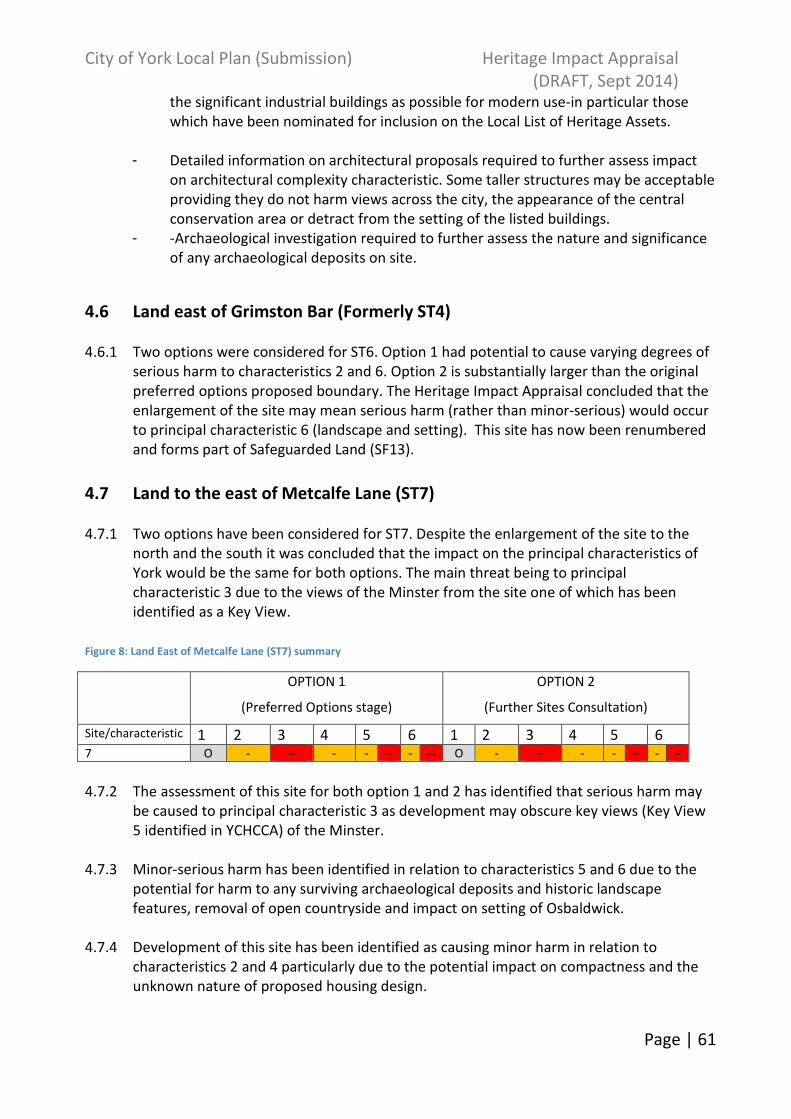
City of York Local Plan (Submission) Heritage Impact Appraisal
(DRAFT, Sept 2014)
Page | 61
the significant industrial buildings as possible for modern use-in particular those
which have been nominated for inclusion on the Local List of Heritage Assets.
- Detailed information on architectural proposals required to further assess impact
on architectural complexity characteristic. Some taller structures may be acceptable
providing they do not harm views across the city, the appearance of the central
conservation area or detract from the setting of the listed buildings.
- -Archaeological investigation required to further assess the nature and significance
of any archaeological deposits on site.
4.6 Land east of Grimston Bar (Formerly ST4)
4.6.1 Two options were considered for ST6. Option 1 had potential to cause varying degrees of
serious harm to characteristics 2 and 6. Option 2 is substantially larger than the original
preferred options proposed boundary. The Heritage Impact Appraisal concluded that the
enlargement of the site may mean serious harm (rather than minor-serious) would occur
to principal characteristic 6 (landscape and setting). This site has now been renumbered
and forms part of Safeguarded Land (SF13).
4.7 Land to the east of Metcalfe Lane (ST7)
4.7.1 Two options have been considered for ST7. Despite the enlargement of the site to the
north and the south it was concluded that the impact on the principal characteristics of
York would be the same for both options. The main threat being to principal
characteristic 3 due to the views of the Minster from the site one of which has been
identified as a Key View.
Figure 8: Land East of Metcalfe Lane (ST7) summary
OPTION 1
(Preferred Options stage)
OPTION 2
(Further Sites Consultation)
Site/characteristic 1 2 3 4 5 6 1 2 3 4 5 6 7 O - -- - - -- - -- O - -- - - -- - --
4.7.2 The assessment of this site for both option 1 and 2 has identified that serious harm may
be caused to principal characteristic 3 as development may obscure key views (Key View
5 identified in YCHCCA) of the Minster.
4.7.3 Minor-serious harm has been identified in relation to characteristics 5 and 6 due to the
potential for harm to any surviving archaeological deposits and historic landscape
features, removal of open countryside and impact on setting of Osbaldwick.
4.7.4 Development of this site has been identified as causing minor harm in relation to
characteristics 2 and 4 particularly due to the potential impact on compactness and the
unknown nature of proposed housing design.

City of York Local Plan (Submission) Heritage Impact Appraisal
(DRAFT, Sept 2014)
Page | 62
4.7.5 Key recommendations/Mitigation:
Option 1&2:
- Reduce site by its eastern edge perhaps in line with buildings around Cottage Farm. A
degree of loss of compactness is unavoidable.
- Further views analysis needed against proposed development plans. Significant views
of the Minster or other important buildings/landscapes should be respected within
proposed scheme.
- Detailed information on architectural proposals required to further assess impact on
architectural complexity characteristic. Characteristic materials and forms of the rural
farmsteads should be used to inspire design. Distinctive spatial configuration should
also be recognised.
- Archaeological investigation required to further assess the nature and significance of
any archaeological deposits or historic landscape features on site.
- Historic field boundaries should be retained and enhanced where possible or at least
respected in the design of the new development.
- Ways of incorporating some of the oldest farm buildings into the new development
should be explored.
- Evaluation required to assess the impact of development on the setting of the
Conservation Area
- Clear margin needed between Conservation Area of Osbaldwick and the new
development. The fields immediately north of the village should remain open to
mitigate some of the impact on the immediate setting of the village.
- Use of strong green edge boundaries to the site and planned open green space may
partially negate some loss of setting when viewed from the ring road.
Option 2 as above and:
- Reduce/move development away from or provide green/open space in the Heworth
Green/Stray area.
4.8 Land north of Monks Cross (ST8)
4.8.1 Only one option was considered for ST8. A summary of the impact of development in this
area on the principal characteristics of York is set out below.
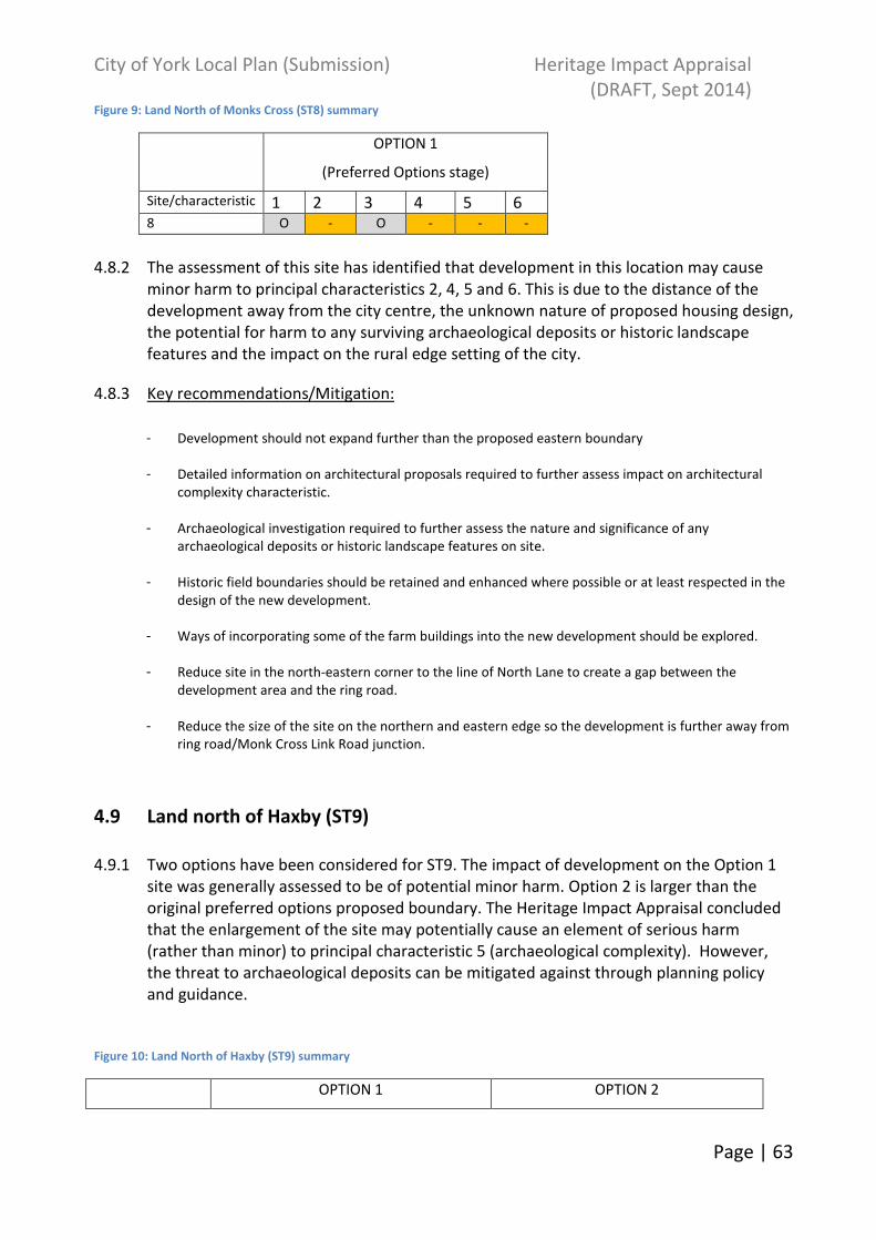
City of York Local Plan (Submission) Heritage Impact Appraisal
(DRAFT, Sept 2014)
Page | 63
Figure 9: Land North of Monks Cross (ST8) summary
OPTION 1
(Preferred Options stage)
Site/characteristic 1 2 3 4 5 6 8 O - O - - -
4.8.2 The assessment of this site has identified that development in this location may cause
minor harm to principal characteristics 2, 4, 5 and 6. This is due to the distance of the
development away from the city centre, the unknown nature of proposed housing design,
the potential for harm to any surviving archaeological deposits or historic landscape
features and the impact on the rural edge setting of the city.
4.8.3 Key recommendations/Mitigation:
- Development should not expand further than the proposed eastern boundary
- Detailed information on architectural proposals required to further assess impact on architectural
complexity characteristic.
- Archaeological investigation required to further assess the nature and significance of any
archaeological deposits or historic landscape features on site.
- Historic field boundaries should be retained and enhanced where possible or at least respected in the
design of the new development.
- Ways of incorporating some of the farm buildings into the new development should be explored.
- Reduce site in the north-eastern corner to the line of North Lane to create a gap between the
development area and the ring road.
- Reduce the size of the site on the northern and eastern edge so the development is further away from
ring road/Monk Cross Link Road junction.
4.9 Land north of Haxby (ST9)
4.9.1 Two options have been considered for ST9. The impact of development on the Option 1
site was generally assessed to be of potential minor harm. Option 2 is larger than the
original preferred options proposed boundary. The Heritage Impact Appraisal concluded
that the enlargement of the site may potentially cause an element of serious harm
(rather than minor) to principal characteristic 5 (archaeological complexity). However,
the threat to archaeological deposits can be mitigated against through planning policy
and guidance.
Figure 10: Land North of Haxby (ST9) summary
OPTION 1 OPTION 2

City of York Local Plan (Submission) Heritage Impact Appraisal
(DRAFT, Sept 2014)
Page | 64
(Preferred Options stage) (Further Sites Consultation)
Site/characteristic 1 2 3 4 5 6 1 2 3 4 5 6 9 O - O - - - O - O - - -- -
4.9.2 The assessment of option 1 and 2 concluded that development in this area may result in
minor harm to principal characteristics 2, 4 and 6. Harm may be caused due to the further
loss of compactness of Haxby, the unknown nature of proposed housing design and the
potential impact on the surviving historic landscape of Haxby. Option 2 development may
also impact upon the perception of the rural setting of the area viewed from Moor Lane.
4.9.3 The assessment of option 1 identified that development in this location may cause minor-
serious harm to principal characteristic 5 due to the increased potential threat to any
surviving archaeological deposits or historic landscape features. This was increased to
minor-serious harm for the enlarged site of option 2 particularly due to the previous
recovery of a Roman coin hoard located within the additional development area.
4.9.3 Key recommendations/Mitigation:
Option 1&2:
- Reduce the site to the existing building line.
- Detailed information on architectural proposals required to further assess impact on
architectural complexity characteristic.
- Archaeological investigation required to further assess the nature and significance of
any archaeological deposits or historic landscape features on site.
- Historic field boundaries should be retained and enhanced where possible or at least
respected in the design of the new development.
- Suitable landscape treatment to the north, east and western boundaries may soften
the urban edge of the development
- New development should maintain a gap and provide screening between it and the
existing residential estate.
Option 2 as above and:
- Pull the development away from the edge of Moor Lane or maintain a green space in
the field closest to it.
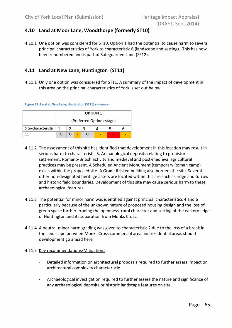
City of York Local Plan (Submission) Heritage Impact Appraisal
(DRAFT, Sept 2014)
Page | 65
4.10 Land at Moor Lane, Woodthorpe (formerly ST10)
4.10.1 One option was considered for ST10. Option 1 had the potential to cause harm to several
principal characteristics of York to characteristic 6 (landscape and setting). This has now
been renumbered and is part of Safeguarded Land (SF12).
4.11 Land at New Lane, Huntington (ST11)
4.11.1 Only one option was considered for ST11. A summary of the impact of development in
this area on the principal characteristics of York is set out below.
Figure 11: Land at New Lane, Huntington (ST11) summary
OPTION 1
(Preferred Options stage)
Site/characteristic 1 2 3 4 5 6 11 O O - O - -- -
4.11.2 The assessment of this site has identified that development in this location may result in
serious harm to characteristic 5. Archaeological deposits relating to prehistoric
settlement, Romano-British activity and medieval and post-medieval agricultural
practices may be present. A Scheduled Ancient Monument (temporary Roman camp)
exists within the proposed site. A Grade II listed building also borders the site. Several
other non-designated heritage assets are located within this are such as ridge and furrow
and historic field boundaries. Development of this site may cause serious harm to these
archaeological features.
4.11.3 The potential for minor harm was identified against principal characteristics 4 and 6
particularly because of the unknown nature of proposed housing design and the loss of
green space further eroding the openness, rural character and setting of the eastern edge
of Huntington and its separation from Monks Cross.
4.11.4 A neutral-minor harm grading was given to characteristic 2 due to the loss of a break in
the landscape between Monks Cross commercial area and residential areas should
development go ahead here.
4.11.5 Key recommendations/Mitigation:
- Detailed information on architectural proposals required to further assess impact on
architectural complexity characteristic.
- Archaeological investigation required to further assess the nature and significance of
any archaeological deposits or historic landscape features on site.
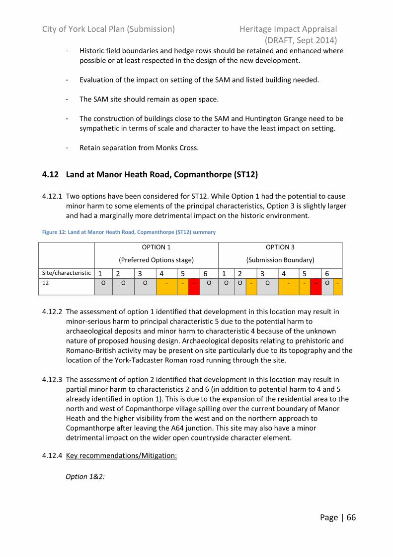
City of York Local Plan (Submission) Heritage Impact Appraisal
(DRAFT, Sept 2014)
Page | 66
- Historic field boundaries and hedge rows should be retained and enhanced where
possible or at least respected in the design of the new development.
- Evaluation of the impact on setting of the SAM and listed building needed.
- The SAM site should remain as open space.
- The construction of buildings close to the SAM and Huntington Grange need to be
sympathetic in terms of scale and character to have the least impact on setting.
- Retain separation from Monks Cross.
4.12 Land at Manor Heath Road, Copmanthorpe (ST12)
4.12.1 Two options have been considered for ST12. While Option 1 had the potential to cause
minor harm to some elements of the principal characteristics, Option 3 is slightly larger
and had a marginally more detrimental impact on the historic environment.
Figure 12: Land at Manor Heath Road, Copmanthorpe (ST12) summary
OPTION 1
(Preferred Options stage)
OPTION 3
(Submission Boundary)
Site/characteristic 1 2 3 4 5 6 1 2 3 4 5 6 12 O O O - - -- O O O - O - - -- O -
4.12.2 The assessment of option 1 identified that development in this location may result in
minor-serious harm to principal characteristic 5 due to the potential harm to
archaeological deposits and minor harm to characteristic 4 because of the unknown
nature of proposed housing design. Archaeological deposits relating to prehistoric and
Romano-British activity may be present on site particularly due to its topography and the
location of the York-Tadcaster Roman road running through the site.
4.12.3 The assessment of option 2 identified that development in this location may result in
partial minor harm to characteristics 2 and 6 (in addition to potential harm to 4 and 5
already identified in option 1). This is due to the expansion of the residential area to the
north and west of Copmanthorpe village spilling over the current boundary of Manor
Heath and the higher visibility from the west and on the northern approach to
Copmanthorpe after leaving the A64 junction. This site may also have a minor
detrimental impact on the wider open countryside character element.
4.12.4 Key recommendations/Mitigation:
Option 1&2:

City of York Local Plan (Submission) Heritage Impact Appraisal
(DRAFT, Sept 2014)
Page | 67
- Detailed information on architectural proposals required to further assess impact on
architectural complexity characteristic.
- Archaeological investigation required to further assess the nature and significance of
any archaeological deposits or historic landscape features on site.
- Historic field boundaries and hedge rows should be retained and enhanced where
possible or at least respected in the design of the new development.
- The Roman road should be respected within the development with information
presented on site to further reveal this and other elements of the historic landscape.
Option 3 as above and:
- Restrict development from spreading further to the west of the current proposed
boundary.
- Reduce size of proposed site so it lies closer to Copmanthorpe centre.
4.13 Land at Moor Lane, Copmanthorpe (ST13)
4.13.1 Only one option was considered for ST13. A summary of the impact of development in
this area on the principal characteristics of York is set out below.
Figure 13: Land at Moor Lane, Copmanthorpe (ST13) summary
OPTION 1
(Preferred Options stage)
Site/characteristic 1 2 3 4 5 6 13 O O O - - O
4.13.2 The assessment of this site has identified that development in this location may result in
minor harm to principal characteristics 4 and 5 due to the unknown nature of proposed
housing design and the potential harm to archaeological deposits
4.13.3 This site does not significantly contribute to the open countryside surrounding York or to
the village setting of Companthorpe.
4.13.4 Key recommendations/Mitigation:
- Detailed information on architectural proposals required to further assess impact on
architectural complexity characteristic.
- Archaeological investigation required to further assess the nature and significance of
any archaeological deposits or historic landscape features on site.

City of York Local Plan (Submission) Heritage Impact Appraisal
(DRAFT, Sept 2014)
Page | 68
4.14 Land to the north of Clifton Moor (ST14)
4.14.1 Two options have been considered for ST14. Both options have the same outcome from
the Heritage Impact Appraisal.
Figure 14: Land to North of Clifton Moor (ST14) summary
OPTION 1
(Preferred Options stage)
OPTION 2
(Further Sites Consultation)
Site/characteristic 1 2 3 4 5 6 1 2 3 4 5 6 14 O -- O - - - -- - -- O -- O - - - -- - --
4.14.2 The assessment of this site both options 1 and 2 has identified that development in this
location may result in serious harm to principal characteristic 2 as this site will cause
urban sprawl outside of the ring road.
4.14.3 The development of this site has been assessed as having the potential to cause minor-
serious harm to characteristics 5 and 6. There are known archaeological deposits on this
site dating from the Iron Age – post-medieval period including an Iron Age and Romano-
British settlement. There is also a high quantity of legible non designated landscape
features. The main impacts on characteristic 6 relate to the rural setting and reduction of
area of coalescence between Haxby, Skelton, outlying farmsteads and York.
4.14.4 The possibility for minor harm was identified against characteristic 4 due to the unknown
nature of proposed housing design while the harm to characteristic 3 was deemed as
potentially causing neutral-minor harm.
4.14.5 Key recommendations/Mitigation:
Option 1 only:
- Proposed development area could be reduced in size with the southern boundary, or
indeed the whole site, shunted further north away from the ring road. The site could
also be reduced in size by removing land on the western edge, close to Skelton.
- Reduce site on its western edge to fall in line with the drain and Moor Lane (or a
compromise between the drain and the proposed edge). This would enhance the gap
between Skelton and the new settlement.
Option 1&2:
- Reduce development area in size and move away from the ring road to make new
settlement rather than an extension.
- Reduce and locate site closer to the ring road with a small green buffer to assist in
maintaining compactness.
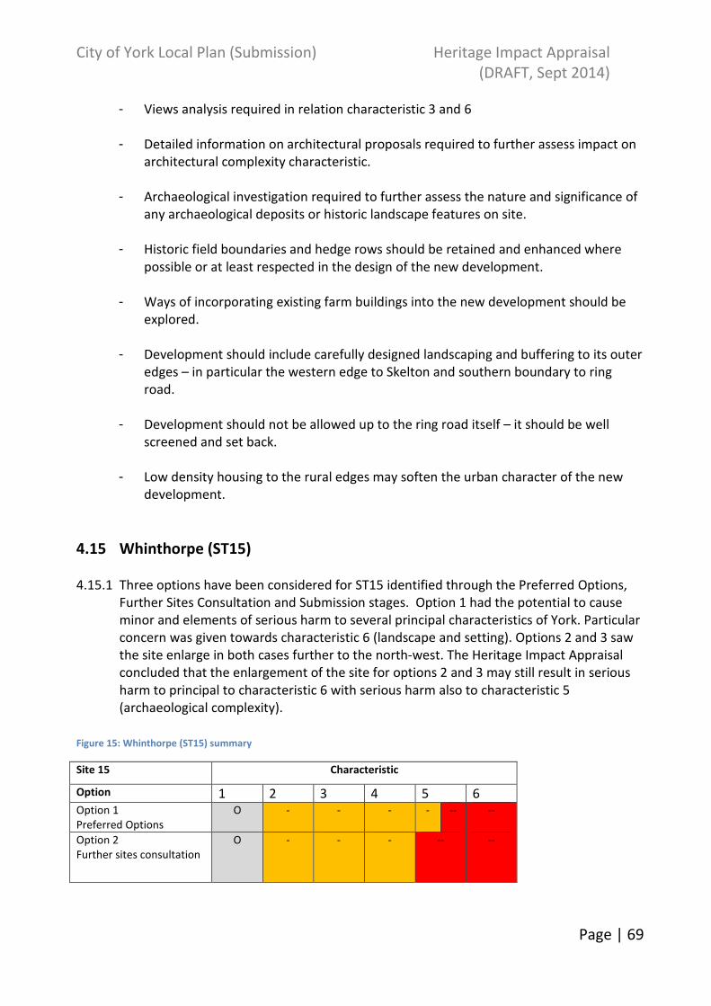
City of York Local Plan (Submission) Heritage Impact Appraisal
(DRAFT, Sept 2014)
Page | 69
- Views analysis required in relation characteristic 3 and 6
- Detailed information on architectural proposals required to further assess impact on
architectural complexity characteristic.
- Archaeological investigation required to further assess the nature and significance of
any archaeological deposits or historic landscape features on site.
- Historic field boundaries and hedge rows should be retained and enhanced where
possible or at least respected in the design of the new development.
- Ways of incorporating existing farm buildings into the new development should be
explored.
- Development should include carefully designed landscaping and buffering to its outer
edges – in particular the western edge to Skelton and southern boundary to ring
road.
- Development should not be allowed up to the ring road itself – it should be well
screened and set back.
- Low density housing to the rural edges may soften the urban character of the new
development.
4.15 Whinthorpe (ST15)
4.15.1 Three options have been considered for ST15 identified through the Preferred Options,
Further Sites Consultation and Submission stages. Option 1 had the potential to cause
minor and elements of serious harm to several principal characteristics of York. Particular
concern was given towards characteristic 6 (landscape and setting). Options 2 and 3 saw
the site enlarge in both cases further to the north-west. The Heritage Impact Appraisal
concluded that the enlargement of the site for options 2 and 3 may still result in serious
harm to principal to characteristic 6 with serious harm also to characteristic 5
(archaeological complexity).
Figure 15: Whinthorpe (ST15) summary
Site 15 Characteristic
Option 1 2 3 4 5 6 Option 1
Preferred Options
O - - - - -- --
Option 2
Further sites consultation
O - - - -- --

City of York Local Plan (Submission) Heritage Impact Appraisal
(DRAFT, Sept 2014)
Page | 70
Option 3
Submission boundary
O - - - -- --
4.15.2 The assessment of options 1, 2 and 3 identified that development in this location may
result in serious harm to principal characteristic 6 primarily due to its role in the open
countryside/rural setting of York and the views afforded from and to the site.
4.15.3 The development of this site was been assessed as having the potential to cause minor-
serious harm to characteristic 5 for option 1 and serious harm for options 2 and 3 due to
the impact on the archaeological deposits in this area. The site includes archaeological
features dating from the Iron Age – post-medieval period including an Iron Age/Romano-
British field system (west of Prospect Farm). Option 2 and 3 boundaries are larger than
option 1 meaning the development of the site therefore has the potential to have a more
destructive impact on archaeological remains. It also includes additional historic
farmsteads.
4.15.4 Possible minor harm was identified against characteristics 2, 3 and 4 for all three option
boundaries particularly due to the potential harm to views to and from the site and the
unknown nature of proposed housing design.
4.15.5 Key recommendations/Mitigation:
Option 1&2:
- Views analysis required. View of Minster should be retained within new
development.
- Development should be well screened and set back from the ring road.
- Detailed information on architectural proposals required to further assess impact on
architectural complexity characteristic. Existing rural buildings have potential to give
local distinctiveness to architectural character.
- Archaeological investigation required to further assess the nature and significance of
any archaeological deposits or historic landscape features on site.
- Historic field boundaries and hedge rows should be retained and enhanced where
possible or at least respected in the design of the new development.
- Locate the development away from the route of the Minster Way.
- Development should include carefully designed landscaping and buffering to its outer
edges and should be well set back and appropriately screened from ring road.
- Reduction of the proposed development area and relocation from the ring road may
further reinforce Whinthorpe as a free-standing settlement.

City of York Local Plan (Submission) Heritage Impact Appraisal
(DRAFT, Sept 2014)
Page | 71
- Further assessment of access to new settlement required.
- Buffering and landscaping required in the vicinity of the SINC and SSSI sites.
Option 3 only:
- Reduce settlement so it is moved away from the roundabout e.g. for the northern
boundary to fall in line with White House Farm and the western edge of Ox Close
Farm.
- Site could be reduced further north away from the airfield e.g. in line with Langworth
Lodge. A strip of fields will remain as a buffer between the development and the
airfield. Appropriate landscaping/screening may assist in providing mitigation against
the loss of openness surrounding the airfield.
4.16 Terry’s Chocolate Factory (formerly ST16)
4.16.1 Only one option was considered for ST16. The Heritage Impact Appraisal concluded that
development in this location may result in serious harm to principal characteristics 3 and
4. Development may potentially impact on the attributes that contribute to, or affect the
setting of the Terry’s/Racecourse Conservation Area, listed buildings within and
surrounding the site and views of landmark buildings.
This site has been renumbered and is now part of Mixed Use (MU2).
4.17 Nestle South (ST17)
4.17.1 Only one option was considered for ST17. A summary of the impact of development in
this area on the principal characteristics of York is set out below.
Figure 16: Nestle South (ST17) summary
OPTION 1
(Preferred Options stage)
Site/characteristic 1 2 3 4 5 6 17 O O - - -- - - O +
4.17.2 The assessment of this site has identified that development in this location may result in
minor-serious harm to principal characteristic 3 and minor harm to principal
characteristics 4 and 5. Development has the potential to seriously harm the attributes
that contribute to, or affect the setting of the Nestle/Rowntree Conservation Area and on
the listed buildings within and surrounding the site. The extant industrial buildings on site
form an important part of York’s heritage relating to chocolate production and the
Nestle/Rowntree brand. Inappropriate development surrounding the extant factory
buildings may detract from their local significance. Therefore a minor harm grading has
been applied to characteristic 4 due to the unknown nature of development design.
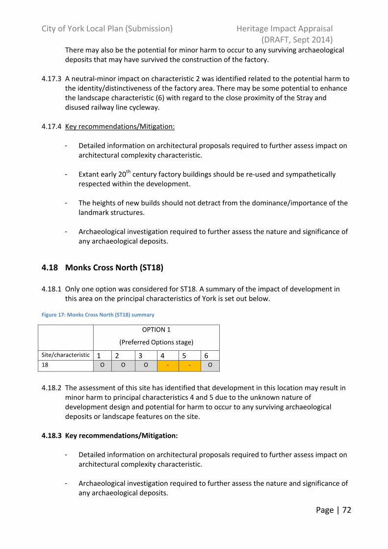
City of York Local Plan (Submission) Heritage Impact Appraisal
(DRAFT, Sept 2014)
Page | 72
There may also be the potential for minor harm to occur to any surviving archaeological
deposits that may have survived the construction of the factory.
4.17.3 A neutral-minor impact on characteristic 2 was identified related to the potential harm to
the identity/distinctiveness of the factory area. There may be some potential to enhance
the landscape characteristic (6) with regard to the close proximity of the Stray and
disused railway line cycleway.
4.17.4 Key recommendations/Mitigation:
- Detailed information on architectural proposals required to further assess impact on
architectural complexity characteristic.
- Extant early 20th
century factory buildings should be re-used and sympathetically
respected within the development.
- The heights of new builds should not detract from the dominance/importance of the
landmark structures.
- Archaeological investigation required to further assess the nature and significance of
any archaeological deposits.
4.18 Monks Cross North (ST18)
4.18.1 Only one option was considered for ST18. A summary of the impact of development in
this area on the principal characteristics of York is set out below.
Figure 17: Monks Cross North (ST18) summary
OPTION 1
(Preferred Options stage)
Site/characteristic 1 2 3 4 5 6 18 O O O - - O
4.18.2 The assessment of this site has identified that development in this location may result in
minor harm to principal characteristics 4 and 5 due to the unknown nature of
development design and potential for harm to occur to any surviving archaeological
deposits or landscape features on the site.
4.18.3 Key recommendations/Mitigation:
- Detailed information on architectural proposals required to further assess impact on
architectural complexity characteristic.
- Archaeological investigation required to further assess the nature and significance of
any archaeological deposits.
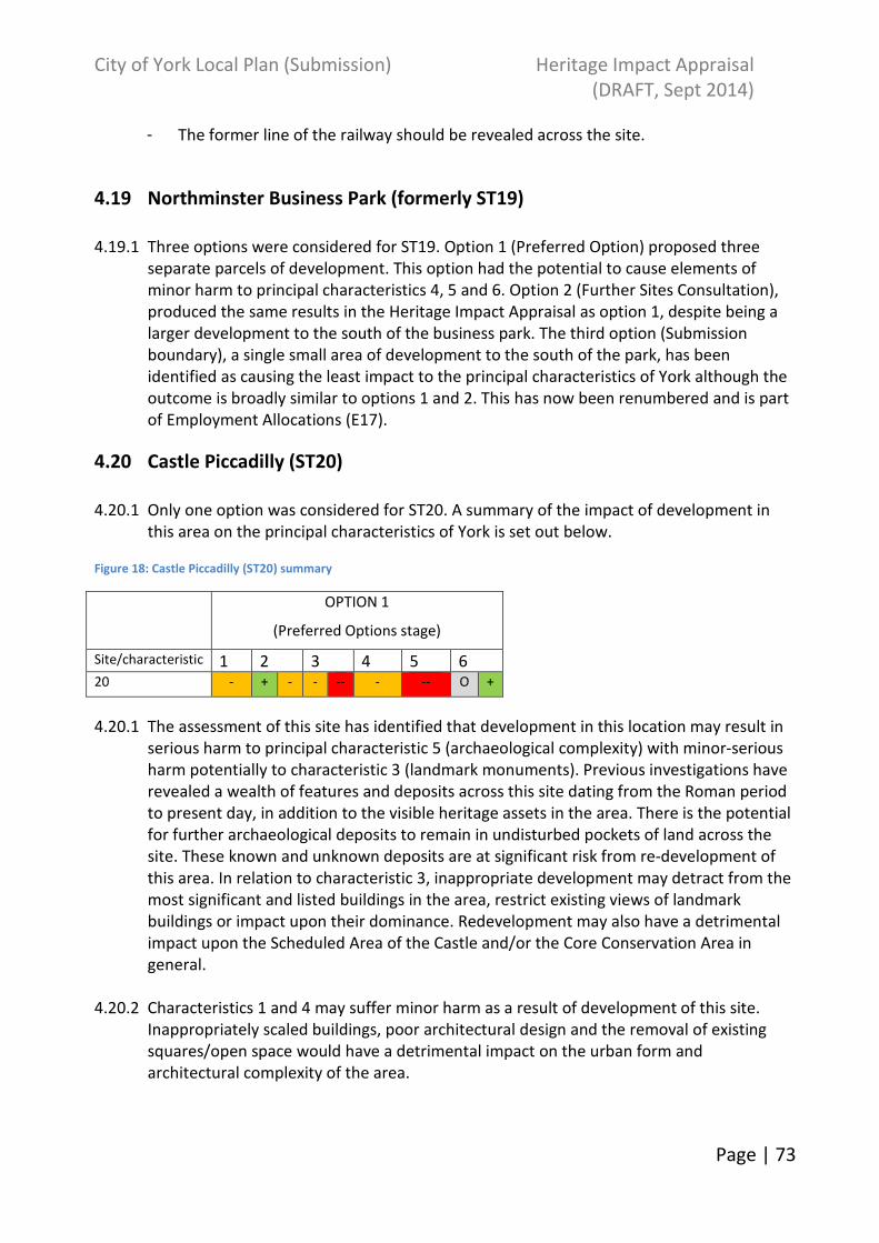
City of York Local Plan (Submission) Heritage Impact Appraisal
(DRAFT, Sept 2014)
Page | 73
- The former line of the railway should be revealed across the site.
4.19 Northminster Business Park (formerly ST19)
4.19.1 Three options were considered for ST19. Option 1 (Preferred Option) proposed three
separate parcels of development. This option had the potential to cause elements of
minor harm to principal characteristics 4, 5 and 6. Option 2 (Further Sites Consultation),
produced the same results in the Heritage Impact Appraisal as option 1, despite being a
larger development to the south of the business park. The third option (Submission
boundary), a single small area of development to the south of the park, has been
identified as causing the least impact to the principal characteristics of York although the
outcome is broadly similar to options 1 and 2. This has now been renumbered and is part
of Employment Allocations (E17).
4.20 Castle Piccadilly (ST20)
4.20.1 Only one option was considered for ST20. A summary of the impact of development in
this area on the principal characteristics of York is set out below.
Figure 18: Castle Piccadilly (ST20) summary
OPTION 1
(Preferred Options stage)
Site/characteristic 1 2 3 4 5 6 20 - + - - -- - -- O +
4.20.1 The assessment of this site has identified that development in this location may result in
serious harm to principal characteristic 5 (archaeological complexity) with minor-serious
harm potentially to characteristic 3 (landmark monuments). Previous investigations have
revealed a wealth of features and deposits across this site dating from the Roman period
to present day, in addition to the visible heritage assets in the area. There is the potential
for further archaeological deposits to remain in undisturbed pockets of land across the
site. These known and unknown deposits are at significant risk from re-development of
this area. In relation to characteristic 3, inappropriate development may detract from the
most significant and listed buildings in the area, restrict existing views of landmark
buildings or impact upon their dominance. Redevelopment may also have a detrimental
impact upon the Scheduled Area of the Castle and/or the Core Conservation Area in
general.
4.20.2 Characteristics 1 and 4 may suffer minor harm as a result of development of this site.
Inappropriately scaled buildings, poor architectural design and the removal of existing
squares/open space would have a detrimental impact on the urban form and
architectural complexity of the area.
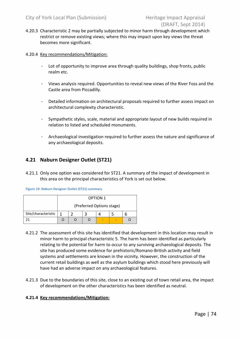
City of York Local Plan (Submission) Heritage Impact Appraisal
(DRAFT, Sept 2014)
Page | 74
4.20.3 Characteristic 2 may be partially subjected to minor harm through development which
restrict or remove existing views; where this may impact upon key views the threat
becomes more significant.
4.20.4 Key recommendations/Mitigation:
- Lot of opportunity to improve area through quality buildings, shop fronts, public
realm etc.
- Views analysis required. Opportunities to reveal new views of the River Foss and the
Castle area from Piccadilly.
- Detailed information on architectural proposals required to further assess impact on
architectural complexity characteristic.
- Sympathetic styles, scale, material and appropriate layout of new builds required in
relation to listed and scheduled monuments.
- Archaeological investigation required to further assess the nature and significance of
any archaeological deposits.
4.21 Naburn Designer Outlet (ST21)
4.21.1 Only one option was considered for ST21. A summary of the impact of development in
this area on the principal characteristics of York is set out below.
Figure 19: Naburn Designer Outlet (ST21) summary
OPTION 1
(Preferred Options stage)
Site/characteristic 1 2 3 4 5 6 21 O O O - - O
4.21.2 The assessment of this site has identified that development in this location may result in
minor harm to principal characteristic 5. The harm has been identified as particularly
relating to the potential for harm to occur to any surviving archaeological deposits. The
site has produced some evidence for prehistoric/Romano-British activity and field
systems and settlements are known in the vicinity. However, the construction of the
current retail buildings as well as the asylum buildings which stood here previously will
have had an adverse impact on any archaeological features.
4.21.3 Due to the boundaries of this site, close to an existing out of town retail area, the impact
of development on the other characteristics has been identified as neutral.
4.21.4 Key recommendations/Mitigation:
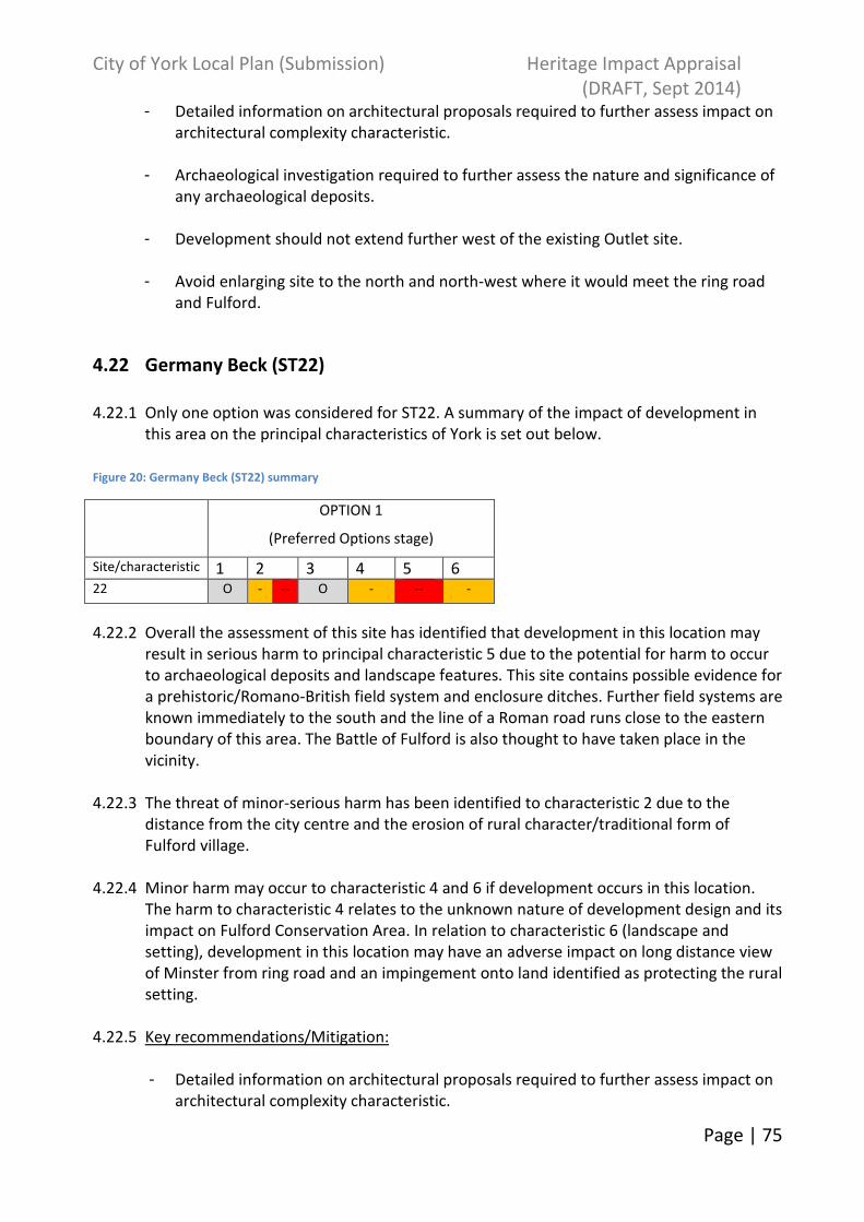
City of York Local Plan (Submission) Heritage Impact Appraisal
(DRAFT, Sept 2014)
Page | 75
- Detailed information on architectural proposals required to further assess impact on
architectural complexity characteristic.
- Archaeological investigation required to further assess the nature and significance of
any archaeological deposits.
- Development should not extend further west of the existing Outlet site.
- Avoid enlarging site to the north and north-west where it would meet the ring road
and Fulford.
4.22 Germany Beck (ST22)
4.22.1 Only one option was considered for ST22. A summary of the impact of development in
this area on the principal characteristics of York is set out below.
Figure 20: Germany Beck (ST22) summary
OPTION 1
(Preferred Options stage)
Site/characteristic 1 2 3 4 5 6 22 O - -- O - -- -
4.22.2 Overall the assessment of this site has identified that development in this location may
result in serious harm to principal characteristic 5 due to the potential for harm to occur
to archaeological deposits and landscape features. This site contains possible evidence for
a prehistoric/Romano-British field system and enclosure ditches. Further field systems are
known immediately to the south and the line of a Roman road runs close to the eastern
boundary of this area. The Battle of Fulford is also thought to have taken place in the
vicinity.
4.22.3 The threat of minor-serious harm has been identified to characteristic 2 due to the
distance from the city centre and the erosion of rural character/traditional form of
Fulford village.
4.22.4 Minor harm may occur to characteristic 4 and 6 if development occurs in this location.
The harm to characteristic 4 relates to the unknown nature of development design and its
impact on Fulford Conservation Area. In relation to characteristic 6 (landscape and
setting), development in this location may have an adverse impact on long distance view
of Minster from ring road and an impingement onto land identified as protecting the rural
setting.
4.22.5 Key recommendations/Mitigation:
- Detailed information on architectural proposals required to further assess impact on
architectural complexity characteristic.

City of York Local Plan (Submission) Heritage Impact Appraisal
(DRAFT, Sept 2014)
Page | 76
- Archaeological investigation required to further assess the nature and significance of
any archaeological deposits.
- Historic field boundaries and hedge rows should be retained and enhanced where
possible or at least respected in the design of the new development.
- Views analysis required.
- Consideration should be given to reducing the size of the proposed development
area to the Germany Beck border to the south.
- Green buffering around the outer edges of development will mitigate the impact of
the boundary between rural landscape and urban fringe.
4.23 Derwenthorpe (ST23)
4.23.1 Only one option was considered for ST23. A summary of the impact of development in
this area on the principal characteristics of York is set out below.
Figure 21: Derwenthorpe (ST23) summary
OPTION 1
(Preferred Options stage)
Site/characteristic 1 2 3 4 5 6 23 O O O - - -
4.23.2 Overall the assessment of this site has identified that development in this location may
result in minor harm to principal characteristics 4, 5 and 6. Harm has been identified due
to the unknown nature of development design, its impact on Osbaldwick Conservation
Area, the potential for harm to occur to archaeological deposits/landscape features and
the impact of the removal of open space surrounding Osbaldwick.
4.23.3 Neolithic and Bronze Age settlement evidence as well as an Iron Age roundhouse and
enclosures were investigated approximately 1.3km to the south at Heslington East prior
to the expansion of the university campus. This suggests that area was settled and farmed
at these times although no evidence exists in Osbaldwick itself. Evidence for Romano-
British settlement is known to the north-east at Apple Tree Farm. Part of a possible 10th-
11th century toft enclosure was investigated on the west side of Metcalfe Lane prior to
development at Derwenthorpe (within this development boundary).
4.23.4 Key recommendations/Mitigation:
- Detailed information on architectural proposals required to further assess impact on
architectural complexity characteristic.
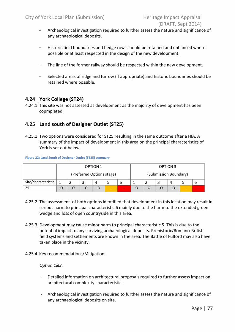
City of York Local Plan (Submission) Heritage Impact Appraisal
(DRAFT, Sept 2014)
Page | 77
- Archaeological investigation required to further assess the nature and significance of
any archaeological deposits.
- Historic field boundaries and hedge rows should be retained and enhanced where
possible or at least respected in the design of the new development.
- The line of the former railway should be respected within the new development.
- Selected areas of ridge and furrow (if appropriate) and historic boundaries should be
retained where possible.
4.24 York College (ST24) 4.24.1 This site was not assessed as development as the majority of development has been
copmpleted.
4.25 Land south of Designer Outlet (ST25)
4.25.1 Two options were considered for ST25 resulting in the same outcome after a HIA. A
summary of the impact of development in this area on the principal characteristics of
York is set out below.
Figure 22: Land South of Designer Outlet (ST25) summary
OPTION 1
(Preferred Options stage)
OPTION 3
(Submission Boundary)
Site/characteristic 1 2 3 4 5 6 1 2 3 4 5 6 25 O O O O - -- O O O O - --
4.25.2 The assessment of both options identified that development in this location may result in
serious harm to principal characteristic 6 mainly due to the harm to the extended green
wedge and loss of open countryside in this area.
4.25.3 Development may cause minor harm to principal characteristic 5. This is due to the
potential impact to any surviving archaeological deposits. Prehistoric/Romano-British
field systems and settlements are known in the area. The Battle of Fulford may also have
taken place in the vicinity.
4.25.4 Key recommendations/Mitigation:
Option 1&3:
- Detailed information on architectural proposals required to further assess impact on
architectural complexity characteristic.
- Archaeological investigation required to further assess the nature and significance of
any archaeological deposits on site.

City of York Local Plan (Submission) Heritage Impact Appraisal
(DRAFT, Sept 2014)
Page | 78
- Historic field boundaries should be retained and enhanced where possible or at least
respected in the design of the new development.
- Planting, particularly to the south and west may assist in protecting an element of the
rural setting of the city in this area. Screening to the western boundary of the
proposed site should also mitigate against any impact on Bishopthorpe.
- Landscape appraisal which also considers the setting of the Conservation Area
required.
- A portion of semi-open countryside will be removed regardless of mitigation.
Option 1 only:
- Assessment of the farm buildings required – retention should be sought of any
significant structures.
4.26 South of Airfield Business Park (ST26)
4.26.1 Only one option was considered for ST26 at Further Sites Consultation. A summary of the
impact of development in this area on the principal characteristics of York is set out
below.
Figure 23: South of Airfield Business Park (ST26) summary
OPTION 2
(Further Sites Consultation)
Site/characteristic 1 2 3 4 5 6 26 O O O O - - O -
4.26.2 The assessment of this site has identified that development in this location may result in
minor harm to principal characteristics 5 and 6. This is due to the potential impact to any
surviving archaeological deposits, impact on the setting of the city and distance between
industrial and rural areas.
4.26.3 Partial minor harm may occur to characteristic 4 however it is a partially industrial area.
4.26.4 Key recommendations/Mitigation:
- Detailed information on architectural proposals required to further assess impact on
architectural complexity characteristic.
- Archaeological investigation required to further assess the nature and significance of
any archaeological deposits on site.

City of York Local Plan (Submission) Heritage Impact Appraisal
(DRAFT, Sept 2014)
Page | 79
- Historic field boundaries should be retained and enhanced where possible or at least
respected in the design of the new development.
- Screening may partially assist in mitigation against the erosion of the semi-rural
setting of the airfield.
- Reduction in distance between Industrial Estate and farmsteads is inevitable.
4.27 Heslington East University Campus Extension (ST27)
4.27.1 Only one option was considered for ST27 at Further Sites Consultation. A summary of the
impact of development in this area on the principal characteristics of York is set out
below. The appraisal concentrates on the new parcel of land to the south of the existing campus.
Figure 24: Heslington East University Campus Extension (ST27) summary
OPTION 2
(Further Sites Consultation)
Site/characteristic 1 2 3 4 5 6 27 O O - O - - --
4.27.2 The assessment of this site has identified that development in this location may result in
serious harm to principal characteristic 6. This is due to the potential loss of open
countryside – affecting the rural setting of the city and the close proximity of the
development to Heslington.
4.27.3 Minor harm may be caused to characteristics 4 and 5 because of the potential for poorly
designed architectural design and impact to any surviving archaeological deposits.
Prehistoric-Romano-British settlement and activity is known across the existing campus
site. This has already been mitigated against through excavation/recording prior to the
construction of the new campus. Further archaeological features (yet unknown) may exist
outside the existing campus boundary.
4.27.4 Partial minor harm may occur to characteristic 2 (compactness) by expansion of this site.
4.27.5 Key recommendations/Mitigation:
- Detailed information on architectural proposals required to further assess impact on
architectural complexity characteristic.
- Archaeological investigation required to further assess the nature and significance of
any archaeological deposits on site.
- Historic landscape features/grain should be retained and enhanced where possible or
at least respected in the design of the new development.

City of York Local Plan (Submission) Heritage Impact Appraisal
(DRAFT, Sept 2014)
Page | 80
- Development will result in the loss of part of the open countryside/rural setting of
York. However, benefits of development may outweigh this loss.
- Screening and landscaping may afford some protection to the rural view from the
ring road.
- Buffer the site on the eastern edge to push and screen the development from the
ring road. Buffering to the west may mitigate against possible harmful impacts to
views from the Conservation Area of Heslington.
- Significant green infrastructure to mitigate effects will be required
- Reduce site by one field on the eastern edge to bring the development a little further
away from the ring road.
- Reduce proposed site to create a new western boundary along Green Lane to enlarge
the gap between Heslington and development (obviously if both this and the above
reduction were made site would be unviable).
4.28 Land Adj to & R/O Windy Ridge & Brecks Lane Huntington (ST28)
4.28.1 Only one option was considered for ST28 at submission boundary stage. A summary of
the impact of development in this area on the principal characteristics of York is set out
below.
Figure 25: Land Adj to & R/O Windy Ridge & Brecks Lane Huntington (ST28) summary
OPTION 3
(Submission Boundary)
Site/characteristic 1 2 3 4 5 6 28 O O - O - - -
4.28.2 The assessment of this site has identified that development in this location may cause
minor harm to principal characteristics 4, 5 and 6. This conclusion was reached due to the
unknown nature of proposed housing design, the potential for harm to any surviving
archaeological deposits and the loss of historic landscape features and open space.
4.28.3 An element of minor harm was identified to characteristic 2 due to the potential removal
of land which separates residential and retail/industrial areas.
4.28.4 Key recommendations/Mitigation:
- The form of development must allow for a transition zone between the rural and
commercial area.
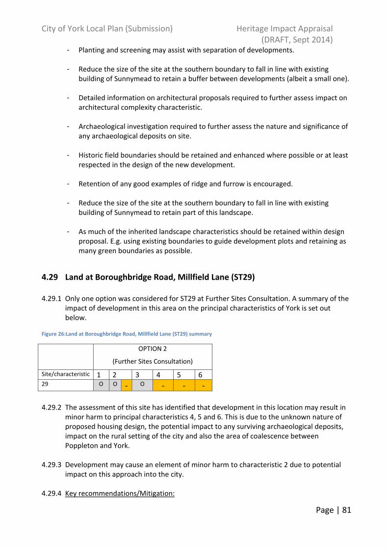
City of York Local Plan (Submission) Heritage Impact Appraisal
(DRAFT, Sept 2014)
Page | 81
- Planting and screening may assist with separation of developments.
- Reduce the size of the site at the southern boundary to fall in line with existing
building of Sunnymead to retain a buffer between developments (albeit a small one).
- Detailed information on architectural proposals required to further assess impact on
architectural complexity characteristic.
- Archaeological investigation required to further assess the nature and significance of
any archaeological deposits on site.
- Historic field boundaries should be retained and enhanced where possible or at least
respected in the design of the new development.
- Retention of any good examples of ridge and furrow is encouraged.
- Reduce the size of the site at the southern boundary to fall in line with existing
building of Sunnymead to retain part of this landscape.
- As much of the inherited landscape characteristics should be retained within design
proposal. E.g. using existing boundaries to guide development plots and retaining as
many green boundaries as possible.
4.29 Land at Boroughbridge Road, Millfield Lane (ST29)
4.29.1 Only one option was considered for ST29 at Further Sites Consultation. A summary of the
impact of development in this area on the principal characteristics of York is set out
below.
Figure 26:Land at Boroughbridge Road, Millfield Lane (ST29) summary
OPTION 2
(Further Sites Consultation)
Site/characteristic 1 2 3 4 5 6 29 O O - O - - -
4.29.2 The assessment of this site has identified that development in this location may result in
minor harm to principal characteristics 4, 5 and 6. This is due to the unknown nature of
proposed housing design, the potential impact to any surviving archaeological deposits,
impact on the rural setting of the city and also the area of coalescence between
Poppleton and York.
4.29.3 Development may cause an element of minor harm to characteristic 2 due to potential
impact on this approach into the city.
4.29.4 Key recommendations/Mitigation:

City of York Local Plan (Submission) Heritage Impact Appraisal
(DRAFT, Sept 2014)
Page | 82
- Detailed information on architectural proposals required to further assess impact on
architectural complexity characteristic.
- Archaeological investigation required to further assess the nature and significance of
any archaeological deposits on site.
- Suitable buffering is needed to front the A59 and A1237 to minimise the impact of
the development on the setting of York as experienced from the various approaches.
- Buffering and landscaping may assist in maintaining a green boundary between the
two settlements.
- The village will also still be separated from the city by the ring road.
4.30 Land to the north of Stockton Lane (ST30)
4.30.1 Only one option was considered for ST30 identified at the Preferred Options stage. A
summary of the impact of development in this area on the principal characteristics of
York is set out below.
Figure 27:Land to the north of Stockton Lane (ST30) summary
OPTION 2
(Further Sites Consultation)
Site/characteristic 1 2 3 4 5 6 30 O O O - - -
4.30.2 The assessment of this site has identified that development in this location may result in
minor harm to principal characteristics 4, 5 and 6. This is due to the unknown nature of
proposed housing design, the potential impact to any surviving archaeological deposits
and impact on the landscape and setting of the city and of the village of Heworth.
4.30.3 Key recommendations/Mitigation:
- -Detailed information on architectural proposals required to further assess impact on
architectural complexity characteristic.
- -Archaeological investigation required to further assess the nature and significance of
any archaeological deposits or historic landscape features on site.
- Historic field boundaries should be retained and enhanced where possible or at least
respected in the design of the new development.
- Use green buffers and landscaping to the edges of development.
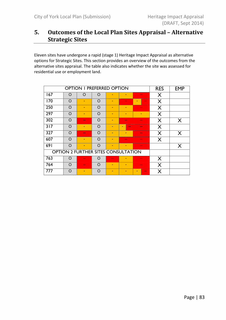
City of York Local Plan (Submission) Heritage Impact Appraisal
(DRAFT, Sept 2014)
Page | 83
5. Outcomes of the Local Plan Sites Appraisal – Alternative
Strategic Sites
Eleven sites have undergone a rapid (stage 1) Heritage Impact Appraisal as alternative
options for Strategic Sites. This section provides an overview of the outcomes from the
alternative sites appraisal. The table also indicates whether the site was assessed for
residential use or employment land.
OPTION 1 PREFERRED OPTION RES EMP 167 O O O - - -- X 170 O - O - -- - -- X 250 O - O - - -- X 297 O - O - - - X 302 O -- O - -- -- X X 317 O - O - - -- -- X 327 O -- O - - -- X X 607 O - O - -- -- X 691 O - O - - -- X
OPTION 2 FURTHER SITES CONSULTATION 763 O -- O -- - -- X 764 O -- O - - -- X 777 O - O - - - -- X
City of York Local Plan (Submission) Heritage Impact Appraisal
(DRAFT, Sept 2014)
Page | 84
6. Outcomes of the Local Plan Sites Appraisal – Allocated
Housing Sites
The local plan has identified sites to accommodate residential growth across the city. In
total 51 Housing Sites have undergone a full Heritage Impact Appraisal, with 46 included as
potential housing allocations in the Local Plan. This section provides an overview of the
outcomes from the sites chosen as Housing Allocations within the Plan.
Key: Characteristic 1: Strong urban form, 2: Compactness, 3: Landmark monuments, 4: Architectural character, 5: Archaeological complexity and 6: Landscape and setting
Option 1
(Preferred Options)
Option 2
(Further Sites Consultation)
Site 1 2 3 4 5 6 1 2 3 4 5 6
H1 O + - + - - - O
H2 O + - - -- -- - -- - -- O + - - -- -- - -- -
H3 O O O - - O - O O O - O - O
H4 O + O + -- - -- O
H5 O O O - - O - O O O - O - O
H6 O O O - - -- -
H7 O O -- - - O
H8 O O O - - O
H9 O O - O - - -- -- O O O - - O -
H10 O O -- - -- -- O
H11 O O - - -- - O
H12 O O O - - O
H13 O O O - - -
H14 O + O + - -- - -- - -- O
H15 O O O - - O
H16 O O O - - - O O O O - - O - O
H17 O O O - O O
H18 O O O - - O
H19 O O - -- - O
H20 O + O O - - O
H21 O O O - - O
H22 O O O - - O
H23 O O O - - -- O
H25 O O O + - - O O O O + - - O
H26 O O - O - - O -
H27 O O - O - - O
H28 O O O - - --
H29 O O O - - O

City of York Local Plan (Submission) Heritage Impact Appraisal
(DRAFT, Sept 2014)
Page | 85
H30 O O - O - -- - -- O O O - -- - - --
H31 O O O - - O
H32 O - O - -- - O
H33 O - O - -- - -- O O - O - -- - -
H34 O O O -- - O O O O - -- - O
H35 O O O - - O
H37 O O - O - - - -- O O - O - - - --
H38 O O O - - O
H39 O O O - - O
H40 O O O - - O
H43 O O O -- - O
H46 O O O - O - - --
H47 O O O - -- - O -
H48 O O O - - O
H49 O O O - - O -
H50 O O O - - - --
H51 O O O - O - O

City of York Local Plan (Submission) Heritage Impact Appraisal
(DRAFT, Sept 2014)
Page | 86
7. Outcomes of the Local Plan Sites Appraisal – Allocated
Employment Sites
The local plan has identified sites to accommodate employment growth across the city. In
total 16 Employment Allocations have undergone a rapid (stage 1) Heritage Impact
Appraisal. This section provides a brief overview of the outcomes from the sites taken
forward as Employment Allocations within the Local Plan. The table also indicates whether
the site was assessed for residential use as well as employment land.
Key: Characteristic 1: Strong urban form, 2: Compactness, 3: Landmark monuments, 4: Architectural character, 5: Archaeological complexity and 6: Landscape and setting
OPTION 1 PREFERRED OPTIONS
Characteristic
Site 1 2 3 4 5 6
E2 O O O O - O
E3 O O O O - O
E4 O O O O - O
E5 O O O O - O
E6 O O O O - O -
E7 O O O O - - O
E8 O O - O - - O
E9 O O O O - O
E10 O O O O O - O
E11 O O O O O O
E12 O O O O - O
E13 O O O O - O
OPTION 2 FURTHER SITES OPTIONS
E14 O O - O O - O
E15 O - + O - - O -
E16 O O O - - O
OPTION 1, 2 & 3 SUBMISSION BOUNDARY
E17 OPT 1
O O O O - - -
E17 OPT 2
O O O O - - O
E17 OPT 3
O O O O - - O -

City of York Local Plan (Submission) Heritage Impact Appraisal
(DRAFT, Sept 2014)
Page | 87
8. Outcomes of the Local Plan Sites Appraisal – Housing and
Employment Alternatives
The local plan has identified alternative sites for bother housing and employment. In total
48 alternative sites have undergone a rapid (Stage 1) Heritage Impact Appraisal. This
section provides a brief overview of the outcomes from the sites chosen as housing and
employment land alternatives within the Plan. The table also indicates whether the site was
assessed for residential and/or employment land. Key: Characteristic 1: Strong urban form, 2: Compactness, 3: Landmark monuments, 4: Architectural character, 5: Archaeological complexity and 6: Landscape and setting
ALTERNATIVE SITES Analysed for:
Residential Employment Characteristic Site 1 2 3 4 5 6 9 O O - O - - - X 30 O O O - - -- X 61 O O O - - - X 87 O O O - O - O O X 130 O + O - + - - + X X 137 O O O - -- - X 147 O O - O - - - X 163 O O - -- -- -- O X X 165 O O O - - -- X 167 O O O - - -- X 171 O -- O -- - -- X 191 O - O - - -- X 200 O - - + - - -- + X 216 O - O - - -- -- X 226 O - O - - -- -- X X 227 O - O - - -- -- X X 229 O - O - - - X 303 O - O - - -- - - -- X 311 O -- O -- -- -- X 318 O + O - O - O X X 565 O O O - - O X 581 O - O - - - X X 598 O O O - - O X X 623 O O -- O - - - -- X 624 O O O - - - X X

City of York Local Plan (Submission) Heritage Impact Appraisal
(DRAFT, Sept 2014)
Page | 88
626 O O O -- - O X X 629 O O - - -- -- -- - X X 645 O O O - - O X 648 O O O -- - O X X 649 O O O - - - O X X 653 O O O - -- O X X 657 O O O - -- -- O X X 660 O O - -- -- -- - X X 661 O O O -- -- O X X 669 O O O - - - O X X 676 O - O - - O - X 700 O O O O O O X X 733 O O O - - O - X 737 O O O - - -- X 738 O O O - - -- X 742 O O O - - O X 744 O O O - - -- X 748 O O O - - - X 749 O O - O - - - X 752 O O O - - - X 753 O -- O - - -- X 758 O O O - - - X 788 O O O - - -- X

City of York Local Plan (Submission) Heritage Impact Appraisal
(DRAFT, Sept 2014)
Page | 89
9. Gypsy and Travellers
The local plan has identified 3 sites to accommodate Gypsy, Travellers and Showpeople.
These sites underwent a full Heritage Impact Appraisal. This section provides a brief
overview of the outcomes from the sites chosen as potential Gypsy, Traveller and
Showpeople sites within the Plan.
OPTION 1 PREFERRED OPTION RES EMP Site 1 2 3 4 5 6 819 O O O O - - - --
818 O O O O - - O -
22 O O O O - - O -
City of York Local Plan (Submission) Heritage Impact Appraisal
(DRAFT, Sept 2014)
Page | 90
10. Safeguarded Land
The local plan has identified 15 sites as Safeguarded Lane. These sites underwent a rapid
(stage 1) Heritage Impact Appraisal. Some have been assessed more fully as they were
previously considered as Strategic Sites. This section provides a brief overview of the
outcomes from the sites chosen as Safeguarded Land within the Plan.
OPTION 1 PREFERRED OPTIONS OPTION 2 FURTHER SITES CONSULTATION
RES EMP
Site 1 2 3 4 5 6 1 2 3 4 5 6 SF1 O - O - - --
SF2 O -- O - - -- --
SF3 O - - - -- --
SF4 O - O - - -- - --
SF5 O - O - - -- -
SF6 O O O O - - O -
SF8 O O O O - - - --
SF9 O - O - - -
SF10 O O - O - - -
SF11 O O O - - -
SF12 O O - O - - - O -- O - - -- X X
SF13 O -- O - - - -- O -- O - - -- X X
SF14 O -- O - - --
OPTION 2 FURTHER SITES CONSULTATION
OPTION 3 SUBMISSION BOUNDARY
SF15 O O O - - - O O - O - - - X

City of York Local Plan (Submission) Heritage Impact Appraisal
(DRAFT, Sept 2014)
Page | 91
11. Mixed Use Sites
The local plan has identified 2 sites for Mixed Use. These sites both underwent a rapid
(stage 1) Heritage Impact Appraisal. This section provides a brief overview of the outcomes
from the sites chosen as Mixed Use within the Plan.
OPTION 1 PREFERRED OPTIONS RES EMP
Site 1 2 3 4 5 6 MU1 - + - -- - -- -- O + X X MU2 O O -- -- - O - X X
City of York Local Plan (Submission) Heritage Impact Appraisal
(DRAFT, Sept 2014)
Page | 92
Strategic Sites Index
(In ‘Allocation Ref’ order in each relevant Chapter)
ST ref.
Site Ref
Site
Proposed Use
Option 1
(Preferred Options)
Option 2
(Further Sites Consultation)
Option 3
(Submission)
ST1 295 n/a 295 British Sugar/Manor School Residential
ST2 321 n/a 321 Former civil service sports ground Residential
ST3 45 n/a 45 The Grain Stores, Water Lane Residential
ST4 35 n/a 35 Land adjacent to Hull Road- Grimston Bar Residential
ST5 293 n/a 293 York Central Opportunity area
ST6 181 181 181 Land East of Grimston Bar Now Safeguarded land (SF
ST7 699 n/a 699 Land to the east of Metcalfe Lane Residential
ST8 329 n/a 329 Land north of Monks Cross Residential
ST9 690 823 823 Land north of Haxby Residential
ST10 148 148 148 Land south of Moor Lane, Woodthorpe Now Safeguarded land (SF
ST11 692 n/a 692 Land at New Lane Huntington Residential
ST12 723 n/a 723 Land at Manor Heath Road, Copmanthorpe
Residential
ST13 131 n/a 131 Land at Moor Lane, Copmanthorpe Residential

City of York Local Plan (Submission) Heritage Impact Appraisal
(DRAFT, Sept 2014)
Page | 93
ST14 698 822 822 Land to the north of Clifton Moor Residential
ST15 727 821 821 Whinthorpe (new settlement) Residential
ST16 470 470 824 Terry’s Now Mixed Use (MU2)
ST17 485 n/a 485 Nestle South Residential
ST18 724 n/a 724 Monks Cross North Employment
ST19 689 793 91 Northminster Business Park Employment – now general employment allocation E17
ST20 725 n/a 725 Castle Piccadilly Opportunity area
ST21 n/a 799 799 Naburn Designer Outlet Leisure
ST22 458 n/a 458 Germany Beck Residential
ST23 457 n/a 457 Derwenthorpe Residential
ST24 461 n/a 461 York College Residential
ST25 n/a 800 800 Land south of Designer Outlet Employment
ST26 n/a 97/815 97 South of Airfield business park Employment
ST27 n/a 794 816 Heslington East University Campus Extension
Employment
ST28 n/a n/a 560 Land Adjacent to & right of Windy Ridge & Brecks Lane Huntington
Residential
ST29 n/a 779 779 Land at Boroughbridge Road, Millfield Lane
Residential
ST30 187 187 187 Land to the north of Stockton Lane Residential

City of York Local Plan (Submission) Heritage Impact Appraisal
(DRAFT, Sept 2014)
Page | 94
Allocations Index
(In ‘Allocation Ref’ order in each relevant Chapter)
Housing Allocations
Allocation Ref
Site Ref
Name
H1 472 Former gas works, 24 Heworth Green
H2 692 Sites by racecourse, Tadcaster Road
H3 121 Burnholme School
H4 202 St Joseph's Monastery
H5 127 Lowfield School
H6 308 Land right of The Square Tadcaster Road
H7 172 Bootham Crescent
H8 58 Askham Bar Park and Ride
H9 177 Land off Askham Lane
H10 656 Barbican Centre
H11 627 Land at Frederick House, Fulford Road
H12 192 Land right of Stockton Lane/Greenfield Park Drive
H13 7 Our Lady's Primary School (existing building footprint)
H14 556 32 Lawrence Street
H15 120 Beckfield Lane Depot
H16 25 Sessions, Huntington Road
H17 631 Burnholme WMC
H18 80 Land off Woodland Chase, Clifton Moor
H19 654 Land at Mill Mount
H20 124 Oakhaven EPH
H21 99 Woolnough House EPH
H22 59 Heworth Lighthouse
H23 98 Grove House EPH
H24 197 Former Bristow's Garage, Fulford Road
H25 651 Heworth Green North
H26 55 Land at Dauby Lane, Elvington
H27 49 Land at the Brecks, Strensall
H28 11 Land to the north of North Lane, Wheldrake
H29 166 Land at Moor Lane Copmanthorpe
H30 322 Land to the south of Strensall village
H31 300 Eastfield Lane, Dunnington
H32 562 The Tannery, Strensall

City of York Local Plan (Submission) Heritage Impact Appraisal
(DRAFT, Sept 2014)
Page | 95
H33 72 Water Tower Land, Dunnington
H34 8 Land north of Church Lane, Skelton
H35 52 Land at Intake Lane, Dunnington
H36 580 Land at Blairgowerie House, Upper Poppleton
H37 6 Land at Greystone Court, Haxby
H38 677 Land right of Rufforth Primary School, Rufforth
H39 8 North of Church Lane, Elvington
H40 193 West Fields, Companthorpe
H41 596 Land adj to 26 and 38 Church Lane, Bishopthorpe
H42 597 Builer Yard, Church Lane, Bishopthorpe
H43 193 Manor Farm Yard Copmanthorpe
H44 618 RO Surgery and 2a/2b Petercroft Lane, Dunnington
H45 579 Land adjacent to 131 Long Ridge Lane, Nether Poppleton
H46 182 Old School Playing Field New Earswick
H47 298 Sites at Connaught Court
H48 757 Haxby Hall EPH
H49 13 Station Yard Wheldrake
H50 180 Malton Road
H51 125 Morrell House EPH
Employment Allocations
Allocation Ref
Site Ref
Name
E2 635 Land north of Monks Cross Drive
E3 37 Ford Garage, Jockey Lane
E4 64 Land at Layerthorpe and James Street
E5 307 Sites at Layerthorpe and James Street
E6 697 Common Lane, Dunnington
E7 599 Wheldrake Industrial Estate
E8 600 Wheldrake Industrial Estate
E9 602 Elvington Industrial Estate
E10 706 Common Lane, Dunnington
E11 639 Annamine Nurseries, Jockey Lane
E12 684 Land at York Business Park
E13 685 End of Great North Way
E14 686 Site to the south of York Business Park
E15 138 Land at Hull Road
E16 742 Upper Poppleton Garden Centre

City of York Local Plan (Submission) Heritage Impact Appraisal
(DRAFT, Sept 2014)
Page | 96
E17 91 Northminster Business Park (formerly ST19)
Safeguarded land
Allocation Ref
Site Ref
Name
SF1 825 Land south of Strensall Village
SF2 824 Cliftongate
SF4 814 Land north of Haxby
SF5 826 Land to the west of Copmanthorpe
SF6 815 Elvington Industrial Estate
SF8 793 Land at Northminster Business Park
SF9 811 Land at Intake Lane, East of Dunnington
SF10 802 Land at Elvington village
SF11 752 East Field, Wheldrake
SF12 148 Land at Moor Lane, Woodthorpe (former ST10)
SF13 181 Land East of Grimston Bar (former ST6)
SF14 810 Earswick
ST15 182 Land to the North of Escrick
Mixed Use Allocations
Allocation Ref
Site Ref
Name
MU1 456 Hungate
MU2 470 Terry’s (formerly ST16)
City of York Local Plan (Submission) Heritage Impact Appraisal
(DRAFT, Sept 2014)
Page | 97
Annex 1: Consultation with English Heritage
July 2013: Response to the Preferred Options Local Plan.
Page Section Comments CYC Comments
- General Given the purpose of the Heritage Impact Assessment
and its role in helping to develop a strategy which
safeguards those elements which contribute to the
special character and setting of the historic city, this
assessment should have, as a starting point, examined
what impact each of the various options might have
upon the six elements which contribute to the special
character of York. Several Options, including some of
those which have been chosen, look likely to harm
elements of York’s Special Character.
As currently structured, it merely assesses the chosen
options (and is therefore , one step beyond what the
current SA is considering.)
Noted. The HIA and Sustainability
Appraisal published at the
Preferred Options Stage have
been used to establish a single
baseline for the policies included
within the Local Plan to ensure all
alternatives have been
considered. This is summarised in
Section 3 and detailed in Annex 2.
- General It is not particularly helpful to merely state “there is
potential for harm to historic character”. Without specifying
what aspect of York’s special character is likely to be
harmed by a proposal, it is difficult to assess what
Noted. The assessment has been
amended to include analysis
against each of the principal
characteristics.

City of York Local Plan (Submission) Heritage Impact Appraisal
(DRAFT, Sept 2014)
Page | 98
mitigation measures might be appropriate to offset that
harm.
The last version of the Heritage Impact Assessment
evaluated each Policy and proposal against the six
characteristics which contribute to the special character
of York. We would suggest that a similar approach is
utilised again. This is particularly important in the case
of the Strategic Sites where each should be assessed
against the six elements identified in the Heritage Topic
Paper as contributing to the special character and setting
of York.
- General The mitigation measures need to be more specific. For
certain sites, harm to elements of York’s historic
environment can only be overcome or reduced by
excluding certain areas from the allocations or through
developing the sites in a certain manner. This
assessment is only of help if it enables developments to
come forward in a manner which will not harm the
historic environment of the City.
Noted. Mitigation measures will
be detailed in individual
assessments.
2 Paragraph 2.1 The impact which the Plan’s Policies might have upon
those elements which contribute to the special
character and setting of the historic city will not always
be clear-cut. In many instances the impact will depend
upon how the Policy is implemented. Therefore, there
Noted and actioned.

City of York Local Plan (Submission) Heritage Impact Appraisal
(DRAFT, Sept 2014)
Page | 99
should be two additional Impacts along the lines of
those set out on page 57 of the Sustainability Appraisal.
This would also assist in better read-across between this
document and the SA.
4 Spatial Strategy,
Policy SS3
(Spatial
Distribution)
The assessment of this Policy needs to consider each of
the sites individually. Given the large number of sites in
this Policy, the only general conclusion is that the effect
will be uncertain – which does not assist the decision-
making process.
Noted. Individual site
assessments have been
undertaken.
4 Spatial Strategy,
Policy SS3
(Safeguarded
Land)
The assessment of this Policy needs to consider each of
the sites individually. Given the large number of sites in
this Policy, the only general conclusion is that the effect
will be uncertain – which does not assist the decision-
making process.
Noted. Individual site
assessments have been
undertaken.
6 Spatial
Strategy,
Policy EMP2
(Provision of
employment
land)
The assessment of this Policy needs to consider each of
the sites individually. Given the large number of sites in
this Policy, the only general conclusion is that the effect
will be uncertain – which does not assist the decision-
making process.
Noted. Individual site
assessments have been
undertaken.
8 Spatial
Strategy,
Policy H3
(Housing land
allocations)
The assessment of this Policy needs to consider each of
the sites individually. Given the large number of sites in
this Policy, the only general conclusion is that the effect
will be uncertain – which does not assist the decision-
making process.
Noted. Individual site
assessments have been
undertaken.

City of York Local Plan (Submission) Heritage Impact Appraisal
(DRAFT, Sept 2014)
Page | 100
January 2014: Initial feedback on the methodology for sites analysis.
As part of ongoing dialogue with English Heritage, a number of comments were received in relation to the draft
methodology shared to enable agreement of the way forward.
English Heritage suggestion: CYC Comments:
(a) Identify those elements which contribute to the special character and
setting of the historic City.
Using the various Character Elements which contribute to the six Principal
Characteristics as set out in Heritage Topic Paper. As well as two additional
elements to the “Landscape and Setting in the City” characteristic:
• Relationship of the historic city of York to the surrounding villages
• The open countryside surrounding York which contributes to the
landscape setting of the historic City
Agreed. We have added these
additional characteristics into the
matrix for assessment.
(b) Assess what contribution this area of land in its current form makes to
the special character and setting of the historic City.
Given the location of most of the Strategic Sites, this is likely to concentrate
mainly on the Character Elements identified in the Heritage Topic Paper
under the Principal Characteristic “Landscape and Setting” (including the
amendments suggested above) although there may be other Character
Elements (such as “Compactness” which might need to be considered).
Noted. Whilst we agree that any
analysis of the Strategic Sites is likely
to focus on the certain
characteristics, further discussion
with the Design, Conservation and
Sustainability team revealed that
they were keen to have analysis for
each of the principal characteristics
to ensure consistency across the

City of York Local Plan (Submission) Heritage Impact Appraisal
(DRAFT, Sept 2014)
Page | 101
assessment and to capture all
applicable issues.
(c) Evaluate the likely impact which the loss of the currently-open area and
its subsequent development might have upon the special character and
setting of the historic City.
This should be made with reference to the latest proposals for the design
and layout of these sites.
Agreed and implemented. We have
included a two-stage approach in
assessing sites. Stage 2 of the sites
assessment will assess site
masterplans where applicable.
(d) Identify what mitigation measures might be used to remove or reduce
any harm to the special character and setting of the historic City.
These might include:-
o Reducing its scale
o Amending its location
o Leaving certain parts of the site undeveloped
o Limiting the scale of buildings or potential uses in certain areas.
o Landscaping etc
Noted. These will be detailed in the
individual assessments.
(e) Consider what opportunities the development of this site might provide
to enhance the special character and setting of the historic City.
Noted. These will be detailed in the
individual assessments.
(f) Assess what impact the development might be likely to have upon those
elements which contribute to the special character and setting of the
historic City with the mitigation measures in place.
Noted. A narrative explaining the
mitigation suggested will be included
in the individual assessments.

City of York Local Plan (Submission) Heritage Impact Appraisal
(DRAFT, Sept 2014)
Page | 102
May-August 2014: Feedback on Strategic Sites HIA.
Site/Characteristic EH Analysis CYC response
ST1.1 & 1.2 British
Sugar
Comments on Rapid
Appraisals (same for
both)
Characteristic 4:
The redevelopment of this former industrial site will not have any impact
upon this Principal Characteristic unless the design of the scheme is of
sufficient quality that it makes a positive contribution to the architectural
legacy of the City. One would hope that the development of every site
allocated in the plan would contribute to this Character Element although,
judging by some recent examples around the City, one would suspect most
will not. Consequently, it might be more appropriate not to make any
reference to the potential that the site can make to this Principal
Characteristic.
CYC believe that there is the potential to improve
this currently derelict site. Generally all sites have
been graded as having the potential to cause minor
harm to this characteristic although we agree that
this depends on the design schemes offered.
2.2 Flat terrain and
views
Mitigation
Producing a views analysis is only the first stage in mitigating any harm on
this element of York’s character. The next step is to ensure that, in any
scheme for the site, important views are safeguarded and that the
possibility of opening up new views of these assets is maximised.
Agree. The appraisals do not go into a lot of detail
regarding mitigation. Assume that a views analysis
would make suggestions regarding important views
and opening up of views.
3.1 Buildings of high
cultural significance
Impact
This Character Element is, essentially, about the City’s legacy of buildings
of high cultural significance. Consequently, the redevelopment of this area
seems unlikely to have much impact upon this particular aspect of York’s
character. It would also seem somewhat improbable that this
redevelopment of this area will contain buildings of high cultural
significance
This may relate to 3.2, Agree although it is not
impossible that buildings of significance may be
built on this site.
4.1 Architectural legacy Impact
The redevelopment this former industrial site will not have any impact
upon this Character Element unless the buildings are of sufficient quality
that they make a positive contribution to the architectural legacy of the
CYC believe that there is the potential to improve
this currently derelict site by contributing to the
architecture of the area. Generally all sites have
been graded as having the potential to cause minor
City of York Local Plan (Submission) Heritage Impact Appraisal
(DRAFT, Sept 2014)
Page | 103
City. One would hope that the development of every site allocated in the
plan would contribute to this Character Element although, judging by some
recent examples around the City, one would suspect most will not.
Consequently, it might be more appropriate not to make any reference to
the potential that the site can make to Character Element 4.1.
harm to this characteristic although we agree that
this depends on the design schemes offered.
6.2 Strays Impact
It should also be noted that the site is visible from (and therefore, could
impact upon the character of) Acomb and Clifton Ings and the River Ouse.
Mitigation
Producing a views analysis is only the first stage in mitigating any harm on
this element of York’s character. The next step is to ensure that, in any
scheme for the site, important views towards the site from Acomb and
Clifton Ings and the River Ouse are safeguarded and that the possibility of
opening up or improving views from these areas is maximised.
Impact
CYC feel that we have covered this and that the
character of Acomb would not be impacted upon.
Mitigation
Agree. The appraisals do not go into a lot of detail
regarding mitigation. Assume that a views analysis
would make suggestions regarding important views
and opening up of views.
6.3 Rivers and Ings Mitigation
Producing a views analysis is only the first stage in mitigating any harm on
this element of York’s character. The next step is to ensure that, in any
scheme for the site, important views towards the site from the River Ouse
are safeguarded and that the possibility of opening up or improving views
from the river is maximised.
Mitigation
Agree. The appraisals do not go into a lot of detail
regarding mitigation. Assume that a views analysis
would make suggestions regarding important views
and opening up of views.
ST2.1 and 2.2
Former Civil Service
Sports Ground
Comments on Rapid
Appraisal
Although Manor School lies to the north of this site, visually the School it is
not perceived as lying within the built-up area of the City. As a result,
extending housing up to the school site will, to some extent, extend the
edge of the main part of the built-up area of York further away from the
City Centre and, thereby, harm its compact nature. Consequently, this
development would be likely to cause Minor Harm to Character Element
2.1
Although the Millfield Road frontage this site lies between existing
development to the north and south, the frontage alongside the A59 is
undeveloped and this open area contributes to the setting and approach
CYC maintain that the impact of development on
Characteristic 2 is neutral-minor harm given the
sequential change to have occurred over the last
few years.
Since the draft version of ST2.1 and 2.2 was sent to
City of York Local Plan (Submission) Heritage Impact Appraisal
(DRAFT, Sept 2014)
Page | 104
to the City from the north-west. The loss of this area could, therefore
result in Minor Harm to the rural edge of the City (Character Element 6.1
(a))
English Heritage the impact of development on
Characteristic 6 has been upgraded to minor harm.
2.1 Contained
concentric form
Impact
Although Manor School lies to the north of this site, visually the School it is
not perceived as lying within the built-up area of the City. As a result,
extending housing up to the school site will, to some extent, extend the
edge of the main part of the built-up area of York further away from the
City Centre and, thereby, harm its compact nature. Consequently, this
development would be likely to cause Minor Harm to this Character
Element.
Mitigation
The precise degree to which the impact upon this particular Character
Element is reduced will be dependent upon the extent to which the north-
western boundary of the site is moved away from the ring road.
The proposed site would have fairly strong
relationship with existing development and is well
connected both to the city centre and Poppleton.
CYC maintain that the impact of development on
characteristic 2 is neutral-minor harm given the
changes that have occurred in the area.
6.1 Views in and out Impact
Although the Millfield Road frontage this site lies between existing
development to the north and south, the frontage alongside the A59 is
undeveloped and this open area contributes to the setting and approach
to the City from the north-west. The site is also partially visible from the
ring road and is perceived as being part of the swathe of open land
between the edge of the main built-up area of York and the A1237. The
loss of this area could, therefore result in Minor Harm to the rural edge of
the City
Mitigation
In order to reduce the harm, the southern part of this site alongside the
A59 should remain undeveloped and existing trees within the site should
be retained.
Agree that minor harm may be caused to this
character element – amendments made to HIA.
Harm can be reduced by suitable mitigation
including design and landscaping.
ST 3 The Grain Stores No comments supplied. Planning permission granted.

City of York Local Plan (Submission) Heritage Impact Appraisal
(DRAFT, Sept 2014)
Page | 105
ST4 Land adj to Hull
Road
Comments on Rapid
Appraisal
Development would result in Serious Harm to Characteristic 6 CYC maintain that the impact of development on
Characteristic 6 is minor harm.
6.1 Views in and out Impact
It might also be noted that development on this site may impact upon
views from the south, especially on the higher areas of the site and thus
impact upon the character of the rural edge of the City when viewed from
the ring road.
Mitigation
One of the ways in which the impact of the site could be mitigated is to
ensure that all development occurs on the lower (i.e. northern) part of the
site with a requirement that none of the development on this site be
visible in views towards the site from the south.
CYC consider that development of site would not
have impact on the setting of the city from the ring
road. However, it is likely to be visible from the
university campus hence impacting on the rural
setting of the campus.
Mitigation
Agree. This would reduce the impact on the
campus setting. CYC maintain that harm can be
reduced by suitable mitigation including design and
landscaping.
6.4 Open countryside
and green belt
Mitigation
Landscaping will not reduce the impact upon this Character Element since
the development still involves the loss of a large area of open countryside.
The only way to reduce the harm is to reduce the size of the site.
Mitigation
The site currently contributes to the apron of open
fields surrounding the city – in this case as seen
from Hull Road and Field Lane. Therefore, a loss of
open space could not be avoided if this site comes
forward but provision of open space and access to
landscape could provide some mitigation.
ST5 York Central
2.5
Identifiable compact
districts
It should be noted that this site presents an opportunity to create an
identifiable new district in the City.
Agreed– amendments made to HIA.
3.4
Monument Clustering
Mitigation
Given the potential for the redevelopment of this site to impact upon
important several key buildings of the City, one of the mitigation measures
should be the development of a Development Brief and Masterplan for the
Mitigation
A development brief for this site is ongoing. This
isn’t seen as a mitigation option rather as part of
the emerging planning process.

City of York Local Plan (Submission) Heritage Impact Appraisal
(DRAFT, Sept 2014)
Page | 106
area.
3.5
Quantity of monuments
Mitigation
Given the potential for the redevelopment of this site to impact upon
important several key buildings of the City, one of the mitigation measures
should be the development of a Development Brief and Masterplan for the
area.
Mitigation
A development brief for this site is ongoing. This
isn’t seen as a mitigation option rather as part of
the emerging planning process.
4.1
Architectural legacy
Mitigation
Given the potential for the redevelopment of this site to impact upon
important several key buildings of the City, one of the mitigation measures
should be the development of a Development Brief and Masterplan for the
area.
Mitigation
A development brief for this site is ongoing. This
isn’t seen as a mitigation option rather as part of
the emerging planning process.
4.2
Variety
Mitigation
Given the potential for the redevelopment of this site to impact upon
important several key buildings of the City, one of the mitigation measures
should be the development of a Development Brief and Masterplan for the
area.
Mitigation
A development brief for this site is ongoing. This
isn’t seen as a mitigation option rather as part of
the emerging planning process.
4.3
Human scale
Mitigation
Given the potential for the redevelopment of this site to impact upon
important several key buildings of the City, one of the mitigation measures
should be the development of a Development Brief and Masterplan for the
area.
Mitigation
A development brief for this site is ongoing. This
isn’t seen as a mitigation option rather as part of
the emerging planning process.
ST6 (Now SF 13)
Land east of Grimston
Bar
Comments on Rapid
Appraisal
Because of the harm that would be caused to Character Element 2.1, the
development of this site would result in Serious Harm to Principal
Characteristic 2.
Because of the harm that would be caused to Character Elements 6.1 and
6.4, the development of this site would result in Serious Harm to Principal
Characteristic 6.
Agree. Since the draft version of ST6 was sent to
English Heritage the impact of development on
Characteristic 2 has been upgraded to serious
harm.
Agree in part. Since the draft version of ST6 was
sent to English Heritage the impact of development
on Characteristic 6 has been upgraded to minor-
serious harm.
City of York Local Plan (Submission) Heritage Impact Appraisal
(DRAFT, Sept 2014)
Page | 107
2.1 Contained
concentric form
Impact
The development of this area would increase the distance between the
city centre and the eastern edge of the built-up area, reducing its
compactness and decreasing the walkable nature of the City.
Mitigation
The impact upon this particular Character Element is not capable of
mitigation. Reducing the size of the site or, for example, limiting
development to the south-west corner only, would be unlikely to
significantly reduce the impact which the development of this area would
have on the compact nature of York.
Impact
Agree with statement – added into HIA.
Mitigation
Agree in part that mitigation measures will not
significantly reduce impact on compactness.
However, the site may be suitable for another use
other than residential. A more
industrial/employment based development may
have less of an impact on compactness than a
residential development.
2.5 Identifiable
compact districts
This site would result in a free-standing residential area poorly related to
the form and character of the City.
Agree with statement – added into HIA.
6.1 Views in and out Impact
Development of this site would bring the edge of the built up area of the
City to within 250 metres of the ring road.
The topography of the site means that any development would dominate
views towards, and be particularly noticeable in views from, the ring road.
Mitigation
The impact upon this particular Character Element is not capable of
mitigation. Reducing the size of the site or limiting development to, for
example, the south-west corner only, would still be likely to harm the rural
edge of the City when viewed from the ring road because of the location of
the site relative to the A64 and its topography.
Impact
Agree with statement on impacts. Upon review the
impacts on element 6.1 have been upgraded to
serious harm.
Mitigation
CYC believe that the impacts can be mitigated to a
degree by the measures given in the HIA.

City of York Local Plan (Submission) Heritage Impact Appraisal
(DRAFT, Sept 2014)
Page | 108
6.4 Open country side
and green belt
Impact
• Development of this site would bring the edge of the built up area of
the City to within 250 metres of the ring road.
• Because of the topography of this site, any development would
dominate views towards, and be particularly noticeable in views from,
the ring road.
• It would erode the rural character of this part of the City
• It would reduce the distance between the built-up edge of the City and
the Livestock Centre from 1.03km to just 500 metres. Even from the
edge of the electricity sub-station, it reduces the gap from 700 metres
to 500 metres. This is a substantial reduction and would further lead to
the urbanisation of the experience of travelling along this part of the
ring road.
Mitigation
The impact upon this particular Character Element is not capable of
mitigation. Reducing the size of the site or limiting development to, for
example, the south-west corner only, would still be likely to harm the rural
edge of the City when viewed from the ring road because of the location of
the site relative to the A64 and its topography.
Impact
Agree with statement on impacts although we
disagree on the degree of harm development may
have upon this element. CYC maintain that the
impact of development on character element 6.4 is
minor harm.
Mitigation
CYC believe that the impacts can be mitigated to a
degree by the measures given in the HIA.

City of York Local Plan (Submission) Heritage Impact Appraisal
(DRAFT, Sept 2014)
Page | 109
6.7 Relationship of the
historic city of York to
the surrounding
villages.
Impact
Development of this site would be likely to result in minor harm-serious
harm to the relationship of York to Murton:-
• It would bring the edge of the built-up area of York to within 770
metres of the south-western part of village of Murton. In view of the
topography of this area, this is likely to be a noticeable reduction and
would be likely to affect the character of the village and its relationship
with York
Mitigation
The impact upon this particular Character Element is capable of mitigation
to some extent by reducing the size of the site and so increasing the
distance between the village and any new development.
Impact
Whilst the development would reduce the physical
distance between York and Murton, this would not
cause serious harm to this relationship from the
ring road. Furthermore the development is distant
from Murton Lane. CYC maintain that the impact of
development on character element 6.7 is minor
harm.
Mitigation
Agree with the statement on mitigation.
ST7.1
Land to the east of
Metcalfe Lane
Comments on Rapid
Appraisal
Because of the harm that would be caused to Character Element 2.1, the
development of this site would result in Serious Harm to Principal
Characteristic 2.
Because of the harm that would be caused to Character Elements 6.1 and
6.4, the development of this site would result in Serious Harm to Principal
Characteristic 6.
Since the draft version of ST7.1 was sent to English
Heritage the impact of development on
Characteristic 2 has been downgraded to minor
harm. It was agreed that although the site was
located someway from the city centre it was a
continuation of existing urban areas and was not as
detrimental to this characteristic as other
proposed sites.
CYC maintain that the impact of development on
Characteristic 6 is minor harm-serious harm.

City of York Local Plan (Submission) Heritage Impact Appraisal
(DRAFT, Sept 2014)
Page | 110
2.1
Contained concentric
form
Mitigation
The precise degree to which it is possible to reduce the impact upon this
particular Character Element to Minor Harm will be dependent upon the
extent to which the eastern boundary of the site is moved away from the
ring road. To be of any assistance to those drawing up revised plans, the
Assessment should give some indication of the extent to which the site
should be reduced in size to bring the impact upon this Character Element
to an acceptable level.
Mitigation
Whilst a pulling back of the eastern edge would
make actual distances between development and
the existing urban form walkable, access to
facilities and green space could be incorporated
into the design to reduce perceived distances to
community centres.
2.5
Identifiable compact
districts
Impact
Given that the original site boundary provides no indication whatsoever of
what this development might look like if allocated, it is not possible to
reach any conclusion about whether or not it might, either, create an
identifiable compact district or, conversely, erode the character of those
communities that exist on the eastern edge of the City. At present,
therefore, it is almost impossible to state what impact this allocation might
have upon this element of York’s character.
The site potentially has strong association with
existing communities. There is the potential to
provide integrated extensions to the existing
communities with additional facilities available to
all. Landscape infrastructure could aid individual
identification of adjacent communities.
Ensuring the creation of compact districts and
identifiable communities is dealt with more fully
through planning policy.
6.1 Views in and out Mitigation
(c) This site is prominent in views from the ring road and the development
of this area would reduce the gap between the A64 and the edge of the
built-up area from 1.3km at its narrowest point to just 575 metres. It
would therefore, result in Serious Harm to the views towards the eastern
edge of the City from the ring road. The only way to reduce this impact
would be to reduce the size of the allocation in order to retain a significant
swathe of open countryside between the new development and the ring
road.
Mitigation
Agree development would be visible from ring
road. The decrease in distance could therefore
potentially harm the quality of view and setting of
Minster/city because currently foreground
buildings are distant with a substantial depth of
open lowland in the foreground, typifying the
setting of the minster and the city. There is scope
for sensitive building design and some landscape
mitigation by creating a suitable landscape setting
for the development along its eastern edge.
Deemed as causing minor harm to this
City of York Local Plan (Submission) Heritage Impact Appraisal
(DRAFT, Sept 2014)
Page | 111
characteristic element.
6.4 Open countryside
and green belt
Impact
(a) Just because the site is not included in one of the areas specifically
identified by the Council in its Green Belt Appraisal does not mean that it
is, necessarily, of lesser importance in the contribution it makes to the
special character or setting of the historic City. Indeed, this site is a key
part of the swathe of open land to the east of the City that contributes to
York’s special character. The second observation that you have made
regarding the site falling specifically outside any specifically earmarked
areas should be deleted.
Mitigation
(a) Given that you have concluded that the loss of the open countryside to
the east of the City is likely to result in Serious Harm to this Character
Element, ensuring that development is no further east than the currently-
proposed eastern boundary will not reduce the harm in any way
whatsoever. By bringing development to within 575 metres of the ring
road, it will result in serious harm to the character of the open countryside
on the eastern side of the city. The only way to reduce this impact would
be to reduce the size of the allocation in order to retain a significant
Impact
Agree that despite not being earmarked for setting
of the city that the tract of land does contribute to
York’s special character.
Mitigation
(a) Agree development would be visible from ring
road. The decrease in distance could therefore
potentially harm the quality of view and setting of
Minster/city because currently foreground
buildings are distant with a substantial depth of
open lowland in the foreground, typifying the
setting of the minster and the city. There is scope
for sensitive building design and some landscape
mitigation by creating a suitable landscape setting
for the development along its eastern edge.
Deemed as causing minor harm to this
characteristic element.

City of York Local Plan (Submission) Heritage Impact Appraisal
(DRAFT, Sept 2014)
Page | 112
swathe of open countryside between the new development and the ring
road.
(d) This development would be just 155 metres from the northern edge of
the Osbaldwick Conservation Area. A large residential development this
close to the village would impact upon the rural setting of the
Conservation Area and result in harm to its setting. The only way to retain
this rural setting is to increase the distance between any new housing
development and the Conservation Area. The Council has a statutory duty
under the provisions of the Planning (Listed Buildings and Conservation
Areas) Act, 1990 to pay “special attention” to “the desirability of preserving
or enhancing the character or appearance” of its Conservation Areas.
Consequently, before allocating this area for development there will need
to be some evaluation of the contribution which this currently-open area
makes to the setting of the Conservation Area and an assessment of what
impact its loss and subsequent development might have upon the
character of the Conservation Area.
(d) CYC agree that a more detailed evaluation is
required. Added to HIA.
6.7 Relationship of the
historic city of York to
the surrounding
villages.
Impact
(a) The development of this area would reduce the gap between the
existing edge of the built-up area of the City from 1.6 km to 720 meters,
which is quite a marked reduction - i.e. it could not be described as leaving
a “reasonable gap” between Murton and the new eastern edge of the City.
This Character Element deals with York’s relationship with the free-
standing settlements in the Green Belt. Therefore, it does not include
Osbaldwick, Tang Hall or any other areas on the edge of the built up area.
Mitigation
(a) In order to retain the relationship of the main built-up area of York with
Murton, a substantial area of open countryside should be retained
between any new housing and the village.
Impact
(a) CYC maintain that the development is located
some distance from Murton and that the impact of
development on this character element is minor as
Murton and York will be separated by a strip of
fields and the ring road and can be mitigated
against though landscaping.
Mitigation
(a) Site offers potential to incorporate suitable
mitigation to mitigate negative effects through
development on the eastern edge of the city.
Principally this will include sensitive, high quality
design and landscaping.

City of York Local Plan (Submission) Heritage Impact Appraisal
(DRAFT, Sept 2014)
Page | 113
ST7.2
Land to the east of
Metcalfe Lane
Because of the harm that would be caused to Character Element 2.1, the
development of this site would result in Serious Harm to Principal
Characteristic 2.
Because of the harm that would be caused to Character Elements 6.1 and
6.4, the development of this site would result in Serious Harm to Principal
Characteristic 6.
Since the draft version of ST7.2 was sent to English
Heritage the impact of development on
Characteristic 2 has been downgraded to minor
harm. It was agreed that although the site was
located someway from the city centre it was a
continuation of existing urban areas and was not as
detrimental to this characteristic as other
proposed sites.
CYC maintain that the impact of development on
Characteristic 6 is minor harm-serious harm.
2.1 Contained
concentric form
Mitigation
The precise degree to which it is possible to reduce the impact upon this
particular Character Element to Minor Harm will be dependent upon the
extent to which the eastern boundary of the site is moved away from the
ring road. To be of any assistance to those drawing up revised plans, the
Assessment should give some indication of the extent to which the site
should be reduced in size to bring the impact upon this Character Element
to an acceptable level.
Mitigation
Whilst a pulling back of the eastern edge would
make actual distances between development and
the existing urban form walkable, access to
facilities and green space could be incorporated
into the design to reduce perceived distances to
community centres.
2.5 Identifiable
compact districts
Impact
Given that the Indicative Block Plans provide little more than general areas
where housing might be developed, it is not possible to reach any real
conclusions about whether or not the development of this area might,
either, create an identifiable compact district or, conversely, erode the
character of those communities that exist on the eastern edge of the City.
Impact
The site potentially has strong association with
existing communities. There is the potential to
provide integrated extensions to the existing
communities with additional facilities available to
all. Landscape infrastructure could aid individual
identification of adjacent communities.
4.3 Human scale Impact
It is not clear why you have made any reference to high-rise buildings in
this Assessment when it has not been identified as an issue in the
evaluation of the Original ST7 (or indeed any of the other sites). Given that
this is a detailed design issue, it would be better not to include it at all.
This was an error and has been corrected. We
think it is worth mentioning that good design
which takes into account scale and architectural
style is required in any new development.
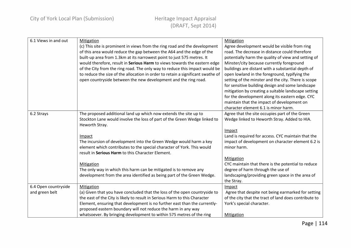
City of York Local Plan (Submission) Heritage Impact Appraisal
(DRAFT, Sept 2014)
Page | 114
6.1 Views in and out Mitigation
(c) This site is prominent in views from the ring road and the development
of this area would reduce the gap between the A64 and the edge of the
built-up area from 1.3km at its narrowest point to just 575 metres. It
would therefore, result in Serious Harm to views towards the eastern edge
of the City from the ring road. The only way to reduce this impact would be
to reduce the size of the allocation in order to retain a significant swathe of
open countryside between the new development and the ring road.
Mitigation
Agree development would be visible from ring
road. The decrease in distance could therefore
potentially harm the quality of view and setting of
Minster/city because currently foreground
buildings are distant with a substantial depth of
open lowland in the foreground, typifying the
setting of the minster and the city. There is scope
for sensitive building design and some landscape
mitigation by creating a suitable landscape setting
for the development along its eastern edge. CYC
maintain that the impact of development on
character element 6.1 is minor harm.
6.2 Strays The proposed additional land up which now extends the site up to
Stockton Lane would involve the loss of part of the Green Wedge linked to
Heworth Stray.
Impact
The incursion of development into the Green Wedge would harm a key
element which contributes to the special character of York. This would
result in Serious Harm to this Character Element.
Mitigation
The only way in which this harm can be mitigated is to remove any
development from the area identified as being part of the Green Wedge.
Agree that the site occupies part of the Green
Wedge linked to Heworth Stray. Added to HIA.
Impact
Land is required for access. CYC maintain that the
impact of development on character element 6.2 is
minor harm.
Mitigation
CYC maintain that there is the potential to reduce
degree of harm through the use of
landscaping/providing green space in the area of
the Stray.
6.4 Open countryside
and green belt
Mitigation
(a) Given that you have concluded that the loss of the open countryside to
the east of the City is likely to result in Serious Harm to this Character
Element, ensuring that development is no further east than the currently-
proposed eastern boundary will not reduce the harm in any way
whatsoever. By bringing development to within 575 metres of the ring
Impact
Agree that despite not being earmarked for setting
of the city that the tract of land does contribute to
York’s special character.
Mitigation

City of York Local Plan (Submission) Heritage Impact Appraisal
(DRAFT, Sept 2014)
Page | 115
road, it will result in serious harm to the character of the open countryside
on the eastern side of the city. The only way to reduce this impact would
be to reduce the size of the allocation in order to retain a significant
swathe of open countryside between the new development and the ring
road.
(d) This development would be just 155 metres from the northern edge of
the Osbaldwick Conservation Area. A large residential development this
close to the village would impact upon the rural setting of the
Conservation Area and result in harm to its setting. The only way to retain
this rural setting is to increase the distance between any new housing
development and the Conservation Area. The Council has a statutory duty
under the provisions of the Planning (Listed Buildings and Conservation
Areas) Act, 1990 to pay “special attention” to “the desirability of preserving
or enhancing the character or appearance” of its Conservation Areas.
Consequently, before allocating this area for development there will need
to be some evaluation of the contribution which this currently-open area
makes to the setting of the Conservation Area and an assessment of what
impact its loss and subsequent development might have upon the
character of the Conservation Area.
(a) Agree development would be visible from ring
road. The decrease in distance could therefore
potentially harm the quality of view and setting of
Minster/city because currently foreground
buildings are distant with a substantial depth of
open lowland in the foreground, typifying the
setting of the minster and the city. There is scope
for sensitive building design and some landscape
mitigation by creating a suitable landscape setting
for the development along its eastern edge.
Deemed as causing minor harm to this
characteristic element.
(d) CYC agree that a more detailed evaluation is
required. Added to the HIA.
6.7 Relationship of the
historic city of York to
the surrounding
villages.
Impact
(a) The development of this area would reduce the gap between the
existing edge of the built-up area of the City from 1.6 km to 720 meters,
which is quite a marked reduction - i.e. it could not be described as a
“reasonable gap.
This Character Element deals with York’s relationship with the free-
standing settlements in the Green Belt. Therefore, it does not include
Osbaldwick, Tang Hall or any other areas on the edge of the built up area.
Mitigation
(a) In order to retain the relationship of the main built-up area of York with
Impact
(a) CYC maintain that the development is located
some distance from Murton and that the impact of
development on this character element is minor as
Murton and York will be separated by a strip of
fields and the ring road and can be mitigated
against though landscaping.
Mitigation
(a) Site offers potential to incorporate suitable
mitigation to mitigate negative effects through
development on the eastern edge of the city.
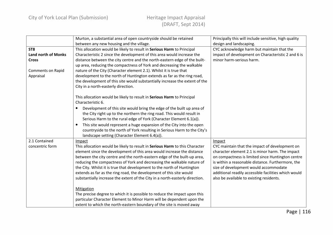
City of York Local Plan (Submission) Heritage Impact Appraisal
(DRAFT, Sept 2014)
Page | 116
Murton, a substantial area of open countryside should be retained
between any new housing and the village.
Principally this will include sensitive, high quality
design and landscaping.
ST8
Land north of Monks
Cross
Comments on Rapid
Appraisal
This allocation would be likely to result in Serious Harm to Principal
Characteristic 2 since the development of this area would increase the
distance between the city centre and the north-eastern edge of the built-
up area, reducing the compactness of York and decreasing the walkable
nature of the City (Character element 2.1). Whilst it is true that
development to the north of Huntington extends as far as the ring road,
the development of this site would substantially increase the extent of the
City in a north-easterly direction.
This allocation would be likely to result in Serious Harm to Principal
Characteristic 6.
• Development of this site would bring the edge of the built up area of
the City right up to the northern the ring road. This would result in
Serious Harm to the rural edge of York (Character Element 6.1(a)).
• This site would represent a huge expansion of the City into the open
countryside to the north of York resulting in Serious Harm to the City’s
landscape setting (Character Element 6.4(a)).
CYC acknowledge harm but maintain that the
impact of development on Characteristic 2 and 6 is
minor harm-serious harm.
2.1 Contained
concentric form
Impact
This allocation would be likely to result in Serious Harm to this Character
element since the development of this area would increase the distance
between the city centre and the north-eastern edge of the built-up area,
reducing the compactness of York and decreasing the walkable nature of
the City. Whilst it is true that development to the north of Huntington
extends as far as the ring road, the development of this site would
substantially increase the extent of the City in a north-easterly direction.
Mitigation
The precise degree to which it is possible to reduce the impact upon this
particular Character Element to Minor Harm will be dependent upon the
extent to which the north-eastern boundary of the site is moved away
Impact
CYC maintain that the impact of development on
character element 2.1 is minor harm. The impact
on compactness is limited since Huntington centre
is within a reasonable distance. Furthermore, the
size of development would accommodate
additional readily accessible facilities which would
also be available to existing residents.

City of York Local Plan (Submission) Heritage Impact Appraisal
(DRAFT, Sept 2014)
Page | 117
from the ring road. To be of any assistance to those drawing up revised
plans, the Assessment should give some indication of the extent to which
the site should be reduced in size to bring the impact upon this Character
Element to an acceptable level.
6.1 Views in and out The Key features column notes that there are few views of the rural edge
of York from the northern ring road. In this particular site, this Character
Element is unlikely to be affected by this development.
Disagree. See CYC HIA.
6.4 Open countryside
and green belt
Impact
Development of this site would cause Serious Harm to the Open
Countryside in this part of the City:-
• Development of this site would bring the edge of the built up area of
the City right up to the northern the ring road. This would result in
Serious Harm to the rural edge of York and, therefore, to Character
Element 6.1(a).
• This site would represent a huge expansion of the City into the open
countryside to the north of York resulting in Serious Harm to the City’s
landscape setting and, therefore, to Character Element 6.4(a).
Mitigation
Reducing the extent of this site “slightly” will have little impact in reducing
the harm which the site in its current configuration would be likely to have
upon this Character Element. The only way to make any real reduction to
the degree of harm would be to reduce the size of the development
substantially and move its north-eastern edge away from the ring-road in
order to create a substantial gap between the development and the
A1237.
Agree that there would be a degree of harm to the
setting of the city by way of loss of open space as
viewed from the ring road. However, CYC maintain
that the impact of development on character
element 6.4 is minor harm.
Mitigation
Agree. Some wording has been changed on HIA.
6.7 Relationship of the
historic city of York to
the surrounding
villages.
Impact
It is unlikely that this development of this site will actually have any impact
upon this particular Character element (Galtres Farm is not a “surrounding
village” nor is it a sizeable development in the open countryside (such as
Askham Bryan College)).
Agree that farms are not sizeable settlements but
are components of a rural community which may
be impacted upon by development.
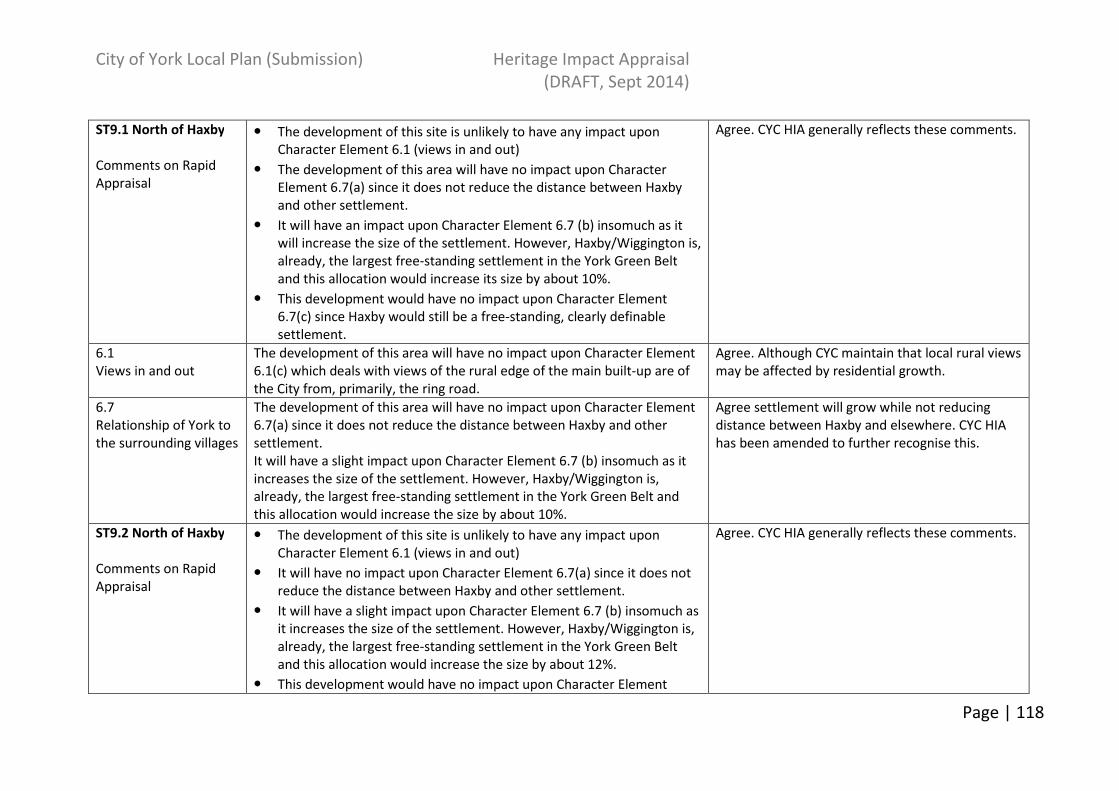
City of York Local Plan (Submission) Heritage Impact Appraisal
(DRAFT, Sept 2014)
Page | 118
ST9.1 North of Haxby
Comments on Rapid
Appraisal
• The development of this site is unlikely to have any impact upon
Character Element 6.1 (views in and out)
• The development of this area will have no impact upon Character
Element 6.7(a) since it does not reduce the distance between Haxby
and other settlement.
• It will have an impact upon Character Element 6.7 (b) insomuch as it
will increase the size of the settlement. However, Haxby/Wiggington is,
already, the largest free-standing settlement in the York Green Belt
and this allocation would increase its size by about 10%.
• This development would have no impact upon Character Element
6.7(c) since Haxby would still be a free-standing, clearly definable
settlement.
Agree. CYC HIA generally reflects these comments.
6.1
Views in and out
The development of this area will have no impact upon Character Element
6.1(c) which deals with views of the rural edge of the main built-up are of
the City from, primarily, the ring road.
Agree. Although CYC maintain that local rural views
may be affected by residential growth.
6.7
Relationship of York to
the surrounding villages
The development of this area will have no impact upon Character Element
6.7(a) since it does not reduce the distance between Haxby and other
settlement.
It will have a slight impact upon Character Element 6.7 (b) insomuch as it
increases the size of the settlement. However, Haxby/Wiggington is,
already, the largest free-standing settlement in the York Green Belt and
this allocation would increase the size by about 10%.
Agree settlement will grow while not reducing
distance between Haxby and elsewhere. CYC HIA
has been amended to further recognise this.
ST9.2 North of Haxby
Comments on Rapid
Appraisal
• The development of this site is unlikely to have any impact upon
Character Element 6.1 (views in and out)
• It will have no impact upon Character Element 6.7(a) since it does not
reduce the distance between Haxby and other settlement.
• It will have a slight impact upon Character Element 6.7 (b) insomuch as
it increases the size of the settlement. However, Haxby/Wiggington is,
already, the largest free-standing settlement in the York Green Belt
and this allocation would increase the size by about 12%.
• This development would have no impact upon Character Element
Agree. CYC HIA generally reflects these comments.

City of York Local Plan (Submission) Heritage Impact Appraisal
(DRAFT, Sept 2014)
Page | 119
6.7(c) since Haxby would still be a free-standing, clearly definable
settlement.
6.1
Views in and out
The development of this area will have no impact upon Character Element
6.1(c) which deals with views of the rural edge of the main built-up are of
the City from, primarily, the ring road.
Agree. Although CYC maintain that local rural views
may be affected by residential growth.
6.7
Relationship of York to
the surrounding villages
The development of this area will have no impact upon Character Element
6.7(a)since it does not reduce the distance between Haxby and other
settlements
It will have a slight impact upon Character Element 6.7 (b) insomuch as it
increases the size of the settlement. However, Haxby/Wiggington is,
already, the largest free-standing settlement in the York Green Belt and
this allocation would increase the size by about 12%.
Agree settlement will grow while not reducing
distance between Haxby and elsewhere. CYC HIA
has been amended to further recognise this.
ST10.1 (Now SF 12)
Land at Moor Lane,
Woodthorpe
Comments on Rapid
Appraisal
This allocation would be likely to result in Minor/Serious Harm to this
element since the development of this area would increase the distance
between the city centre and the south-western edge of the built-up area,
reducing the compactness of York and decreasing the walkable nature of
the City.
What you have noted down here would be likely to result in Serious Harm
to Principal Characteristic 6:-
• By reducing the distance between the edge of the built-up area of the
City and the ring–road, it would result in would harm one of the Key
Views of the Minster (Character Element 6.1(a)).
• It would result in Serious Harm to the rural edge of the City when
viewed from the ring road (Character Element 6.1(c)).
This site would represent a large expansion of the City into the open
countryside to the south of York resulting in Serious Harm to the City’s
landscape setting (Character Element 6.4(a)).
CYC maintain that the impact of development on
Characteristic 2 is neutral-minor harm and on 6 is
minor harm.
2.1 Contained
concentric form
Impact
This allocation would be likely to result in Minor/Serious Harm to this
Character element since the development of this area would increase the
distance between the city centre and the south-western edge of the built-
Impact
CYC maintain that the impact of development on
character element 2.1 as neutral as the proposed
development relates closely to the existing
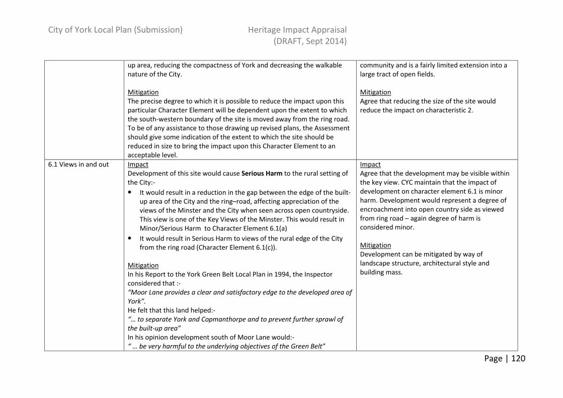
City of York Local Plan (Submission) Heritage Impact Appraisal
(DRAFT, Sept 2014)
Page | 120
up area, reducing the compactness of York and decreasing the walkable
nature of the City.
Mitigation
The precise degree to which it is possible to reduce the impact upon this
particular Character Element will be dependent upon the extent to which
the south-western boundary of the site is moved away from the ring road.
To be of any assistance to those drawing up revised plans, the Assessment
should give some indication of the extent to which the site should be
reduced in size to bring the impact upon this Character Element to an
acceptable level.
community and is a fairly limited extension into a
large tract of open fields.
Mitigation
Agree that reducing the size of the site would
reduce the impact on characteristic 2.
6.1 Views in and out Impact
Development of this site would cause Serious Harm to the rural setting of
the City:-
• It would result in a reduction in the gap between the edge of the built-
up area of the City and the ring–road, affecting appreciation of the
views of the Minster and the City when seen across open countryside.
This view is one of the Key Views of the Minster. This would result in
Minor/Serious Harm to Character Element 6.1(a)
• It would result in Serious Harm to views of the rural edge of the City
from the ring road (Character Element 6.1(c)).
Mitigation
In his Report to the York Green Belt Local Plan in 1994, the Inspector
considered that :-
“Moor Lane provides a clear and satisfactory edge to the developed area of
York”.
He felt that this land helped:-
“… to separate York and Copmanthorpe and to prevent further sprawl of
the built-up area”
In his opinion development south of Moor Lane would:-
“ … be very harmful to the underlying objectives of the Green Belt”
Impact
Agree that the development may be visible within
the key view. CYC maintain that the impact of
development on character element 6.1 is minor
harm. Development would represent a degree of
encroachment into open country side as viewed
from ring road – again degree of harm is
considered minor.
Mitigation
Development can be mitigated by way of
landscape structure, architectural style and
building mass.

City of York Local Plan (Submission) Heritage Impact Appraisal
(DRAFT, Sept 2014)
Page | 121
[Inspector’s Report, page 95, Paragraph C78.4].
In view of these comments, the only way to reduce this impact would be a
substantial reduction in the size of the allocation in order to retain a
significant swathe of open countryside between the new development and
the ring road.
6.4 Open countryside
and green belt
Impact
(a) Just because the site is not included in one of the areas specifically
identified by the Council in its Green Belt Appraisal does not mean that it
is, necessarily, of lesser importance in the contribution it makes to the
special character or setting of the historic City. Indeed, this site is a key
part of the swathe of open land to the south of the City that contributes to
York’s special character. In view of the comments of the York Green Belt
Local Plan Inspector, the incursion into the open countryside to the south
of the City would be likely to result in Serious harm to Character Element
6.4(a).
Mitigation
The precise degree to which it is possible to reduce the impact upon this
particular Character Element will be dependent upon the extent to which
the southern and western boundaries of the site are moved away from the
ring road. To be of any assistance to those drawing up revised plans, the
Assessment should give some indication of the extent to which the site
should be reduced in size to bring the impact upon this Character Element
to an acceptable level.
Impact
Agree that development will impact upon the open
countryside especially as experienced from Moor
Lane – see CYC HIA. However, CYC maintain that
the impact of development on character element
6.4 is minor harm-serious harm.
Mitigation
Agree that reducing size of site would reduce the
impact of development (although this may also
affect viability).
ST10.2
Land at Moor Lane,
Woodthorpe
Comments on Rapid
Appraisal
This allocation would be likely to result in Serious Harm to Character
Element 2.1(a) since the development of this area would increase the
distance (by a further half mile or so) between the city centre and the
south-western edge of the built-up area, reducing the compactness of York
and decreasing the walkable nature of the City.
On reflection CYC agree that the development may
cause serious harm to Characteristic 2. HIA
amended.
2.1 Impact Impact
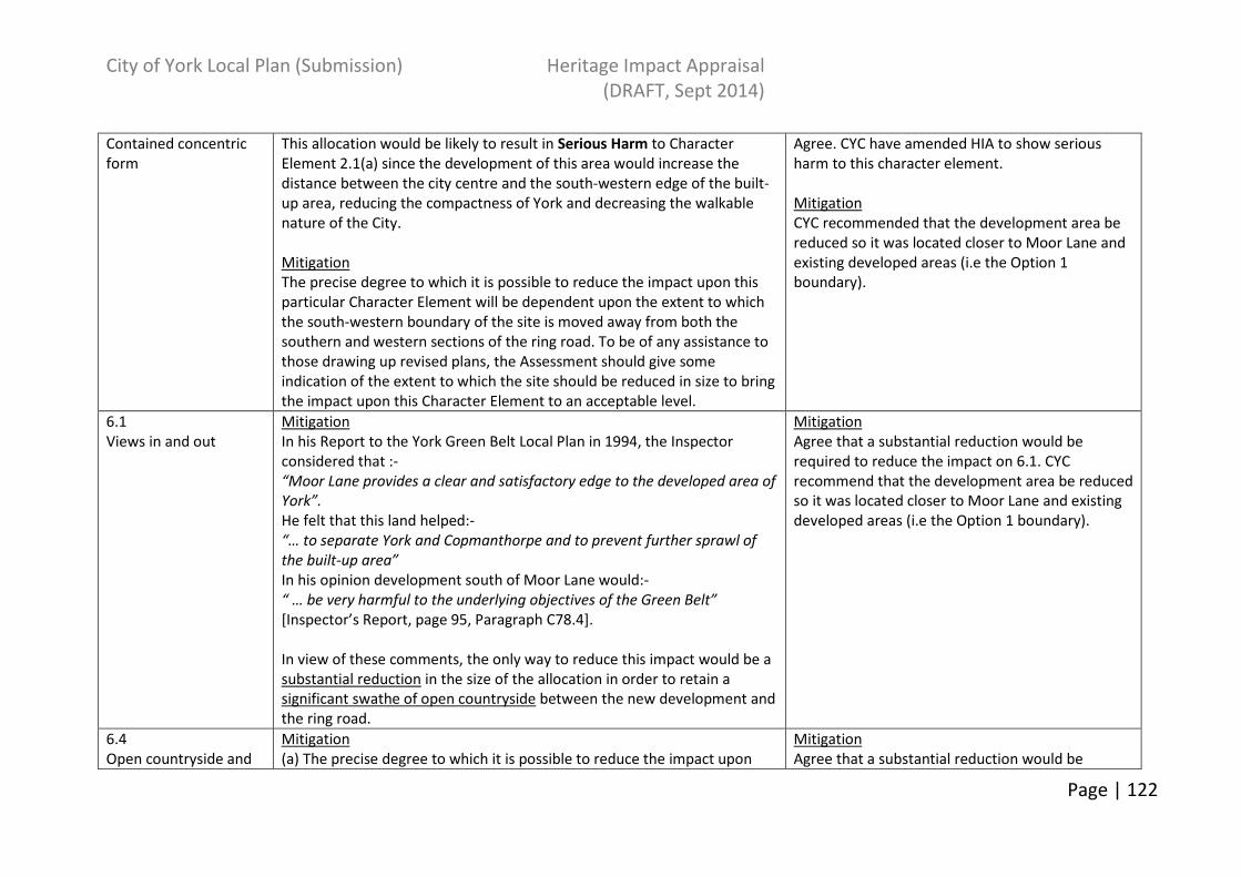
City of York Local Plan (Submission) Heritage Impact Appraisal
(DRAFT, Sept 2014)
Page | 122
Contained concentric
form
This allocation would be likely to result in Serious Harm to Character
Element 2.1(a) since the development of this area would increase the
distance between the city centre and the south-western edge of the built-
up area, reducing the compactness of York and decreasing the walkable
nature of the City.
Mitigation
The precise degree to which it is possible to reduce the impact upon this
particular Character Element will be dependent upon the extent to which
the south-western boundary of the site is moved away from both the
southern and western sections of the ring road. To be of any assistance to
those drawing up revised plans, the Assessment should give some
indication of the extent to which the site should be reduced in size to bring
the impact upon this Character Element to an acceptable level.
Agree. CYC have amended HIA to show serious
harm to this character element.
Mitigation
CYC recommended that the development area be
reduced so it was located closer to Moor Lane and
existing developed areas (i.e the Option 1
boundary).
6.1
Views in and out
Mitigation
In his Report to the York Green Belt Local Plan in 1994, the Inspector
considered that :-
“Moor Lane provides a clear and satisfactory edge to the developed area of
York”.
He felt that this land helped:-
“… to separate York and Copmanthorpe and to prevent further sprawl of
the built-up area”
In his opinion development south of Moor Lane would:-
“ … be very harmful to the underlying objectives of the Green Belt”
[Inspector’s Report, page 95, Paragraph C78.4].
In view of these comments, the only way to reduce this impact would be a
substantial reduction in the size of the allocation in order to retain a
significant swathe of open countryside between the new development and
the ring road.
Mitigation
Agree that a substantial reduction would be
required to reduce the impact on 6.1. CYC
recommend that the development area be reduced
so it was located closer to Moor Lane and existing
developed areas (i.e the Option 1 boundary).
6.4
Open countryside and
Mitigation
(a) The precise degree to which it is possible to reduce the impact upon
Mitigation
Agree that a substantial reduction would be
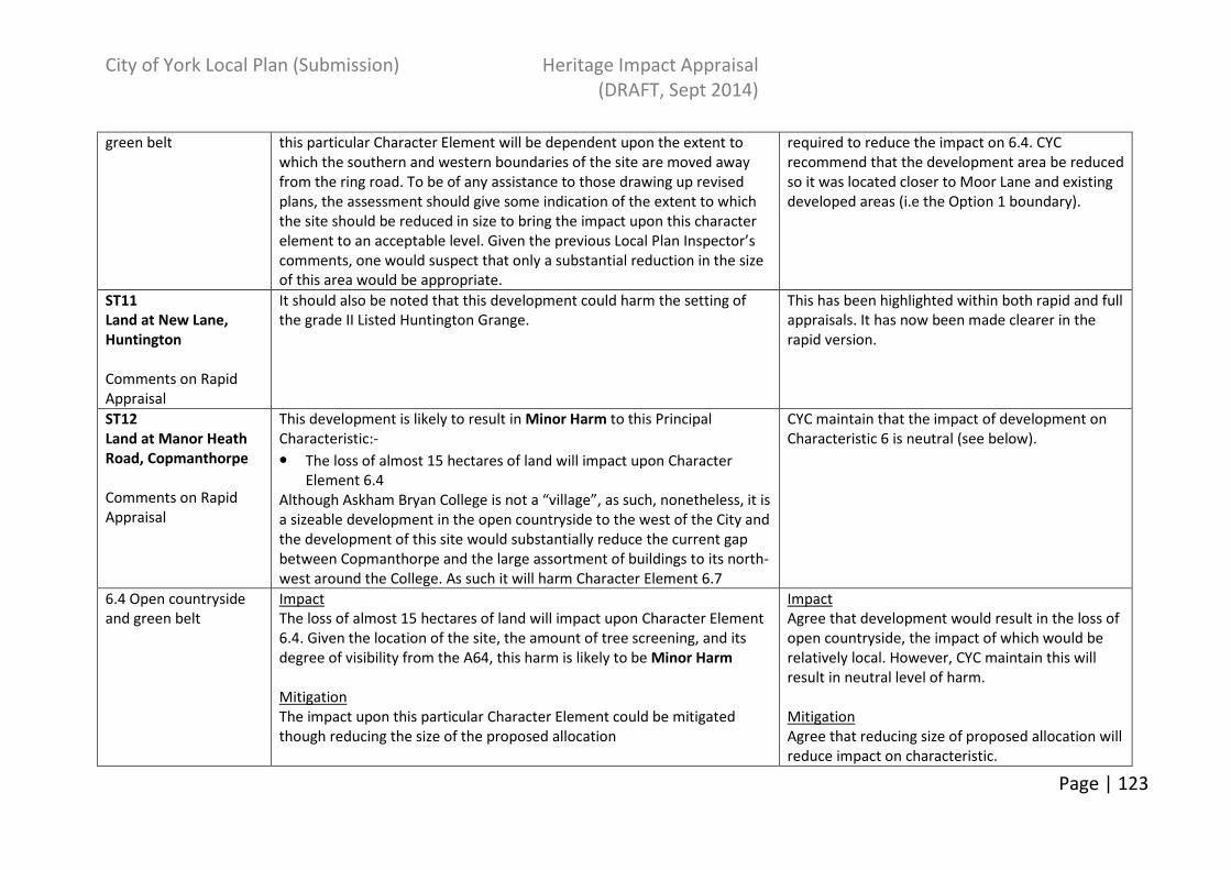
City of York Local Plan (Submission) Heritage Impact Appraisal
(DRAFT, Sept 2014)
Page | 123
green belt this particular Character Element will be dependent upon the extent to
which the southern and western boundaries of the site are moved away
from the ring road. To be of any assistance to those drawing up revised
plans, the assessment should give some indication of the extent to which
the site should be reduced in size to bring the impact upon this character
element to an acceptable level. Given the previous Local Plan Inspector’s
comments, one would suspect that only a substantial reduction in the size
of this area would be appropriate.
required to reduce the impact on 6.4. CYC
recommend that the development area be reduced
so it was located closer to Moor Lane and existing
developed areas (i.e the Option 1 boundary).
ST11
Land at New Lane,
Huntington
Comments on Rapid
Appraisal
It should also be noted that this development could harm the setting of
the grade II Listed Huntington Grange.
This has been highlighted within both rapid and full
appraisals. It has now been made clearer in the
rapid version.
ST12
Land at Manor Heath
Road, Copmanthorpe
Comments on Rapid
Appraisal
This development is likely to result in Minor Harm to this Principal
Characteristic:-
• The loss of almost 15 hectares of land will impact upon Character
Element 6.4
Although Askham Bryan College is not a “village”, as such, nonetheless, it is
a sizeable development in the open countryside to the west of the City and
the development of this site would substantially reduce the current gap
between Copmanthorpe and the large assortment of buildings to its north-
west around the College. As such it will harm Character Element 6.7
CYC maintain that the impact of development on
Characteristic 6 is neutral (see below).
6.4 Open countryside
and green belt
Impact
The loss of almost 15 hectares of land will impact upon Character Element
6.4. Given the location of the site, the amount of tree screening, and its
degree of visibility from the A64, this harm is likely to be Minor Harm
Mitigation
The impact upon this particular Character Element could be mitigated
though reducing the size of the proposed allocation
Impact
Agree that development would result in the loss of
open countryside, the impact of which would be
relatively local. However, CYC maintain this will
result in neutral level of harm.
Mitigation
Agree that reducing size of proposed allocation will
reduce impact on characteristic.

City of York Local Plan (Submission) Heritage Impact Appraisal
(DRAFT, Sept 2014)
Page | 124
6.7 Relationship of the
historic city of York to
the surrounding
villages.
Impact
Although Askham Bryan College is not a “village”, as such, nonetheless, it is
a sizeable development in the open countryside to the west of the City and
the development of this site would substantially reduce the current gap
between Copmanthorpe and the large assortment of buildings to its north-
west around the College. Because this would, theoretically, threaten the
free-standing character of Copmanthorpe, this is likely to result in Minor
Harm to this Character Element.
Mitigation
The impact upon this particular Character Element could be reduced by
increasing the gap between the northern edge of the allocated area and
Askham Bryan College.
Impact and mitigation
The ring road and junction contributes a major
mitigating factor to a reduction in gap between
Askham Bryan and Copmanthorpe.
Site has potential to contribute to overall tree
cover that is read in the landscape in association
with Askham Bryan College.
CYC maintain that the impact of development is
likely to be neutral.
ST 13 Land at Moor
Lane Copmanthorpe
No comments supplied
ST14.1
Land to the north of
Monks Cross
Comments on Rapid
Appraisal
What you have noted down here would be likely to result in Serious Harm
to Principal Characteristic 6.
CYC maintain that site 14.1 will result in minor-
serious harm being caused to Characteristic 6 as
stated in the HIA.
6.4 Open countryside
and green belt
Impact
(a) The development of this site would fundamentally affect the
impression that one has of the rural setting of this part of the City when
travelling along the ring road since there would be development on both
sides of the 1237.
(d) Development of this area would bring development to within 620
metres of the village of Skelton. This would have a significant impact upon
the rural setting of this settlement and would constitute Serious Harm to
this aspect of this Character Element.
Impact
(a) Agree, but there are varying degrees of
sensitivity and existing influences along the full
length of the ring road which contributes to
the overall impression of York.
(d) Agree there is potential harm. See CYC HIA
comments.
Mitigation
(a) Agree reducing size of site would reduce the
degree of harm, but CYC maintain that there

City of York Local Plan (Submission) Heritage Impact Appraisal
(DRAFT, Sept 2014)
Page | 125
Mitigation
(a) Landscaping of the site’s outer edges will not reduce the impact upon
this Character Element since the development still involves the loss of a
large area of open countryside to the north of the city. Moving
development further north away from the ring road, again, will not lessen
the harm to this Character Element. The only way to reduce the harm is to
reduce the size of the site.
(d) Moving the western edge of the development back to the drain would
not result in much appreciable defence to the rural setting of Skelton. The
only way to make any real reduction in the degree of harm would be to
reduce the size of the development substantially or, alternatively, move it
further north in order to create s substantial gap between the village and
any new housing.
The development of housing in this area would be unlikely to have any
positive effects on the setting of Skelton.
are other measures available as well – See CYC
HIA comments.
(d) There are consequences relating to the
sensitivity of Moor Lane and its relationship with
Skelton by potentially moving the site further
north. See also point (a) above.
6.7 Relationship of the
historic city of York to
the surrounding
villages.
Impact
The development of this area impacts upon two aspects of this Character
Element. Firstly is the effect it has on the setting of the settlements of
Haxby and Skelton and their relationship with one another. The second is
how this new development, itself, relates to York. With the exception of
Earswick which is considerably smaller in size, the settlements beyond the
ring road are all free-standing. This development would simply be an
extension to Clifton Moor and would therefore not reflect the way in
which settlements have developed around York.
Mitigation
“Slightly” reducing the size of the development would not have a great
impact upon the harm that this scale of development in this location would
be likely to have upon this Character Element. Any development in this
location would compromise the separation between, and distinct
Impact
The allocation has to be of a certain size for it to
operate as a free-standing community rather than
an extension to development on the inside of the
ring road. CYC have already recognized this as
having the potential for significant harm. Agree
separation from the ring road would assist in this.
Mitigation
CYC maintain that, although an element of harm
will still be caused to this character element a
partial site reduction and well
designed/landscaped development will mitigate
against the amount of harm caused. The existing
woodland blocks in the area also provide
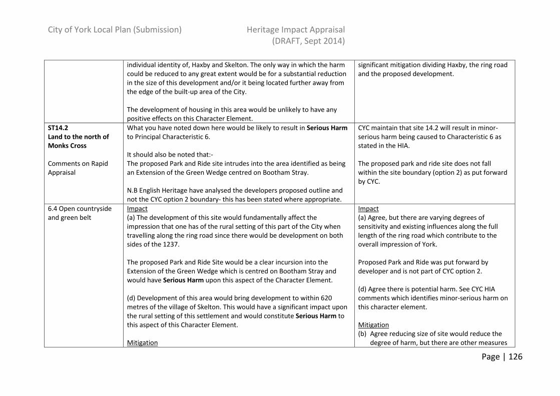
City of York Local Plan (Submission) Heritage Impact Appraisal
(DRAFT, Sept 2014)
Page | 126
individual identity of, Haxby and Skelton. The only way in which the harm
could be reduced to any great extent would be for a substantial reduction
in the size of this development and/or it being located further away from
the edge of the built-up area of the City.
The development of housing in this area would be unlikely to have any
positive effects on this Character Element.
significant mitigation dividing Haxby, the ring road
and the proposed development.
ST14.2
Land to the north of
Monks Cross
Comments on Rapid
Appraisal
What you have noted down here would be likely to result in Serious Harm
to Principal Characteristic 6.
It should also be noted that:-
The proposed Park and Ride site intrudes into the area identified as being
an Extension of the Green Wedge centred on Bootham Stray.
N.B English Heritage have analysed the developers proposed outline and
not the CYC option 2 boundary- this has been stated where appropriate.
CYC maintain that site 14.2 will result in minor-
serious harm being caused to Characteristic 6 as
stated in the HIA.
The proposed park and ride site does not fall
within the site boundary (option 2) as put forward
by CYC.
6.4 Open countryside
and green belt
Impact
(a) The development of this site would fundamentally affect the
impression that one has of the rural setting of this part of the City when
travelling along the ring road since there would be development on both
sides of the 1237.
The proposed Park and Ride Site would be a clear incursion into the
Extension of the Green Wedge which is centred on Bootham Stray and
would have Serious Harm upon this aspect of the Character Element.
(d) Development of this area would bring development to within 620
metres of the village of Skelton. This would have a significant impact upon
the rural setting of this settlement and would constitute Serious Harm to
this aspect of this Character Element.
Mitigation
Impact
(a) Agree, but there are varying degrees of
sensitivity and existing influences along the full
length of the ring road which contribute to the
overall impression of York.
Proposed Park and Ride was put forward by
developer and is not part of CYC option 2.
(d) Agree there is potential harm. See CYC HIA
comments which identifies minor-serious harm on
this character element.
Mitigation
(b) Agree reducing size of site would reduce the
degree of harm, but there are other measures

City of York Local Plan (Submission) Heritage Impact Appraisal
(DRAFT, Sept 2014)
Page | 127
(a) Landscaping of the site’s outer edges will not reduce the impact upon
this Character Element since the development still involves the loss of a
large area of open countryside to the north of the city. Moving
development further north away from the ring road, again, will not lessen
the harm to this Character Element. The only way to reduce the harm is to
reduce the size of the site.
The harm that would be caused to the Extension of the Green Wedge
which is centred on Bootham Stray can be mitigated completely by the
deletion of this aspect of the Scheme.
(d) Development of this area would result in Serious Harm to the setting of
the village of Skelton. Ensuring that no development occurs further west of
the current site boundary would not reduce the harm that this scale of
development in this location would be likely to have upon this Character
Element. The only way to make any real reduction in the degree of harm
would be to reduce the size of the development substantially or,
alternatively, move it further north in order to create a substantial gap
between the village and any new housing.
The development of housing in this area would be unlikely to have any
positive effects on the setting of Skelton.
available as well – See CYC HIA comments.
(d) Agree that reducing the size of the
development would reduce the potential harm.
The suggested green infrastructure would also
reduce visual impact. Moving development further
north has implications for Moor Lane and
setting/approach to Skelton. See also comments to
(a) above.
6.7 Relationship of the
historic city of York to
the surrounding
villages.
Impact
The development of this area impacts upon two aspects of this Character
Element. Firstly is the effect it has on the setting of the settlements of
Haxby and Skelton and their relationship with one another. The second is
how this new development, itself, relates to York. With the exception of
Earswick which is considerably smaller in size, the settlements beyond the
ring road are all free-standing. This development would simply be an
extension to Clifton Moor and would therefore not reflect the way in
which settlements have developed around York.
Impact
The allocation has to be of a certain size for it to
operate as a free-standing community rather than
an extension to development on the inside of the
ring road. Agree separation from the ring road
would assist in this.
Mitigation
CYC maintain that, although an element of harm
will still be caused to this character element a
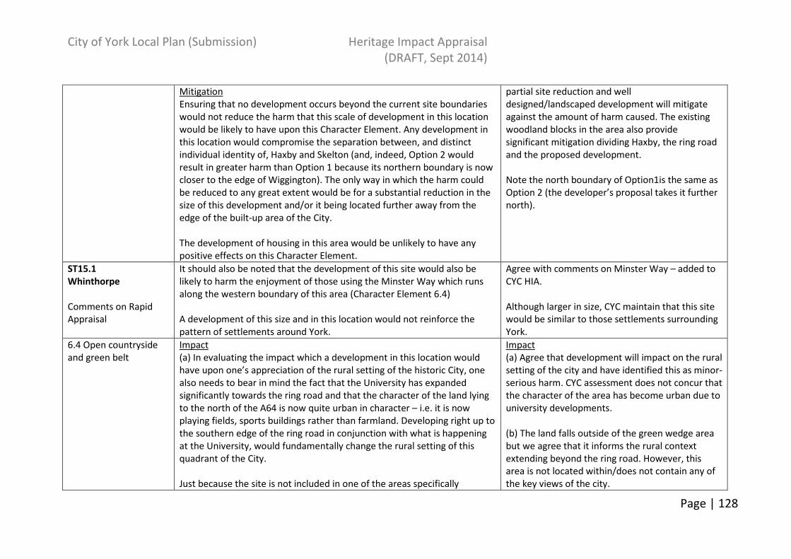
City of York Local Plan (Submission) Heritage Impact Appraisal
(DRAFT, Sept 2014)
Page | 128
Mitigation
Ensuring that no development occurs beyond the current site boundaries
would not reduce the harm that this scale of development in this location
would be likely to have upon this Character Element. Any development in
this location would compromise the separation between, and distinct
individual identity of, Haxby and Skelton (and, indeed, Option 2 would
result in greater harm than Option 1 because its northern boundary is now
closer to the edge of Wiggington). The only way in which the harm could
be reduced to any great extent would be for a substantial reduction in the
size of this development and/or it being located further away from the
edge of the built-up area of the City.
The development of housing in this area would be unlikely to have any
positive effects on this Character Element.
partial site reduction and well
designed/landscaped development will mitigate
against the amount of harm caused. The existing
woodland blocks in the area also provide
significant mitigation dividing Haxby, the ring road
and the proposed development.
Note the north boundary of Option1is the same as
Option 2 (the developer’s proposal takes it further
north).
ST15.1
Whinthorpe
Comments on Rapid
Appraisal
It should also be noted that the development of this site would also be
likely to harm the enjoyment of those using the Minster Way which runs
along the western boundary of this area (Character Element 6.4)
A development of this size and in this location would not reinforce the
pattern of settlements around York.
Agree with comments on Minster Way – added to
CYC HIA.
Although larger in size, CYC maintain that this site
would be similar to those settlements surrounding
York.
6.4 Open countryside
and green belt
Impact
(a) In evaluating the impact which a development in this location would
have upon one’s appreciation of the rural setting of the historic City, one
also needs to bear in mind the fact that the University has expanded
significantly towards the ring road and that the character of the land lying
to the north of the A64 is now quite urban in character – i.e. it is now
playing fields, sports buildings rather than farmland. Developing right up to
the southern edge of the ring road in conjunction with what is happening
at the University, would fundamentally change the rural setting of this
quadrant of the City.
Just because the site is not included in one of the areas specifically
Impact
(a) Agree that development will impact on the rural
setting of the city and have identified this as minor-
serious harm. CYC assessment does not concur that
the character of the area has become urban due to
university developments.
(b) The land falls outside of the green wedge area
but we agree that it informs the rural context
extending beyond the ring road. However, this
area is not located within/does not contain any of
the key views of the city.

City of York Local Plan (Submission) Heritage Impact Appraisal
(DRAFT, Sept 2014)
Page | 129
identified by the Council in its Green Belt Appraisal does not mean that it
is, necessarily, of lesser importance in the contribution it makes to the
special character or setting of the historic City. Indeed, this site is a key
part of the swathe of open land to the south of the City that contributes to
York’s special character. The second observation that you have made
regarding the site falling specifically outside any specifically earmarked
areas should be deleted.
An additional consideration is the adverse impact which a new access off
the A64 (with, potentially, a grade-separated junction and lighting) would
be likely to have upon the rural setting of the City.
It should also be noted that the development of this area would also be
likely to harm the enjoyment of those using the Minster Way which runs
along the western and southern boundaries of this area
Mitigation
(a) The most way to ensure that this Character element is safeguarded is
to:-
• Reduce the size of the development and/or locate it considerably
further away from the ring road and
• Ensure that any access to the development does not come from a new
junction on the A64.
Locate the development away from the route of the Minster Way
Agree that consideration is needed of the impact
of creating new access off A64 as land take here
may be substantial. Added to CYC HIA.
Agree with comments on Minster Way – added to
CYC HIA.
Mitigation
See CYC HIA original comments.
Suggested Minster Way mitigation added to HIA.
ST15.2 Whinthorpe
6.4 Open countryside
and green belt
As above As above
ST16, 17 and 18 No comments received. ST 16 and 17 are existing commitments. For ST18 see ST8.
ST19.1
Northminster Business
Park
What you have noted down here would be likely to result in Serious Harm
to Principal Characteristic 6.
• The proposed Allocation would increase the size of the Business Park
CYC maintain that minor harm could be caused to
characteristic 6 although several amendments
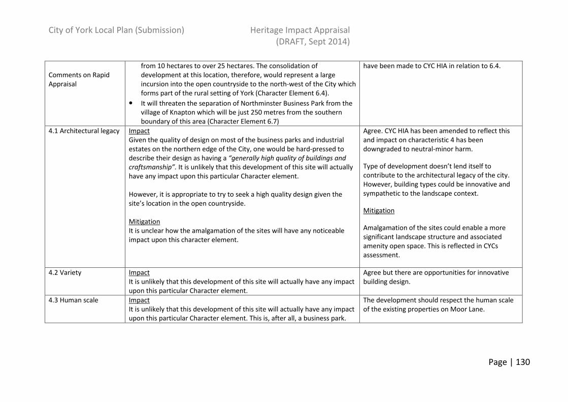
City of York Local Plan (Submission) Heritage Impact Appraisal
(DRAFT, Sept 2014)
Page | 130
Comments on Rapid
Appraisal
from 10 hectares to over 25 hectares. The consolidation of
development at this location, therefore, would represent a large
incursion into the open countryside to the north-west of the City which
forms part of the rural setting of York (Character Element 6.4).
• It will threaten the separation of Northminster Business Park from the
village of Knapton which will be just 250 metres from the southern
boundary of this area (Character Element 6.7)
have been made to CYC HIA in relation to 6.4.
4.1 Architectural legacy Impact
Given the quality of design on most of the business parks and industrial
estates on the northern edge of the City, one would be hard-pressed to
describe their design as having a “generally high quality of buildings and
craftsmanship”. It is unlikely that this development of this site will actually
have any impact upon this particular Character element.
However, it is appropriate to try to seek a high quality design given the
site’s location in the open countryside.
Mitigation
It is unclear how the amalgamation of the sites will have any noticeable
impact upon this character element.
Agree. CYC HIA has been amended to reflect this
and impact on characteristic 4 has been
downgraded to neutral-minor harm.
Type of development doesn’t lend itself to
contribute to the architectural legacy of the city.
However, building types could be innovative and
sympathetic to the landscape context.
Mitigation
Amalgamation of the sites could enable a more
significant landscape structure and associated
amenity open space. This is reflected in CYCs
assessment.
4.2 Variety Impact
It is unlikely that this development of this site will actually have any impact
upon this particular Character element.
Agree but there are opportunities for innovative
building design.
4.3 Human scale Impact
It is unlikely that this development of this site will actually have any impact
upon this particular Character element. This is, after all, a business park.
The development should respect the human scale
of the existing properties on Moor Lane.

City of York Local Plan (Submission) Heritage Impact Appraisal
(DRAFT, Sept 2014)
Page | 131
4.4 Craftsmanship Impact
It is unlikely that this development of this site will actually have any impact
upon this particular Character element. This is, after all, a business park.
Agree that lack of craftsmanship would not be
detrimental to characteristic 4. Business Park use
does not necessarily preclude the opportunity for
incorporating the use of craftsmanship.
6.1 Views in and out Impact
It is unlikely that this development of this site will actually have any impact
upon the Key Features identified under this particular Character element.
Disagree - see CYC HIA.
6.4 Open countryside
and green belt
Impact
Development of this site would cause Serious Harm to the Open
Countryside in this part of the City:-
• The proposed Allocation would increase the size of the Business Park
from 10 hectares to over 25 hectares. The consolidation of
development at this location, therefore, would represent a large
incursion into the open countryside to the north-west of the City which
forms part of the rural setting of York.
Mitigation
• The impact upon this particular Character Element could be mitigated
though reducing the size of the proposed allocation
• Its impact could also be reduced by having a more compact form – as
opposed to the random extensions from the existing business park.
Since EH were sent a draft version of ST19.1
several additions have been made to 6.4 including
reference to the rural setting of Moor Lane and
setting of the city. However, CYC maintain that the
impact of development on character element 6.4 is
minor harm.
The expansion of the business park would bring
development closer to the ring road. The degree of
harm is somewhat mitigated by existing vegetation
and development.
Mitigation
Agree. However, CYC maintain that other methods
of mitigation such as landscaping and design could
be used to mitigate against this character element
rather than a simple reduction in size.
6.7 Relationship of the
historic city of York to
the surrounding
villages.
Impact
Development of this site in its current form would be likely to result in
Serious Harm to this character Element since it will threaten the
separation of Northminster Business Park from the village of Knapton
which will be just 250 metres from the southern boundary of this area
See CYC HIA. The degree of harm is dependent on
master plan.
Mitigation
Agree. This option has now been added into the
HIA.

City of York Local Plan (Submission) Heritage Impact Appraisal
(DRAFT, Sept 2014)
Page | 132
Mitigation
The impact upon this particular Character Element is capable of mitigation
by deleting the south-eastern block and reducing the southern most extent
of the south-western block
ST19.2
Northminster Business
Park
Comments on Rapid
Appraisal
What you have noted down here would be likely to result in Serious Harm
to Principal Characteristic 6.
• The proposed Allocation would increase the size of the Business Park
from 10 hectares to over 40 hectares. The consolidation of
development at this location, therefore, would represent a large
incursion into the open countryside to the north-west of the City which
forms part of the rural setting of York (Character Element 6.4).
• It will threaten the separation of Northminster Business Park from the
village of Knapton which will be just 250 metres from the southern
boundary of this area (Character Element 6.7)
CYC maintain that minor harm could be caused to
characteristic 6 although several amendments
have been made to CYC HIA in relation to 6.4.
4.1 Architectural legacy Impact
Given the quality of design on most of the business parks and industrial
estates on the northern edge of the City, one would be hard-pressed to
describe their design as having a “generally high quality of buildings and
craftsmanship”. It is unlikely that this development of this site will actually
have any impact upon this particular Character element.
However, it is appropriate to try to seek a high quality design given the
site’s location in the open countryside.
Mitigation
It is unclear how the amalgamation of the sites will have any noticeable
impact upon this character element.
Agree. CYC HIA has been amended to reflect this
and impact on characteristic 4 has been
downgraded to neutral-minor harm.
Type of development doesn’t lend itself to
contribute to the architectural legacy of the city.
However, building types could be innovative and
sympathetic to the landscape context.
4.2 Variety Impact
It is unlikely that this development of this site will actually have any impact
upon this particular Character element.
Agree but there are opportunities for innovative
building design.
4.3 Human scale Impact
It is unlikely that this development of this site will actually have any impact
The development should respect the human scale

City of York Local Plan (Submission) Heritage Impact Appraisal
(DRAFT, Sept 2014)
Page | 133
upon this particular Character element. This is, after all, a business park. of the existing properties on Moor Lane.
4.4 Craftsmanship Impact
It is unlikely that this development of this site will actually have any impact
upon this particular Character element. This is, after all, a business park.
Agree that lack of craftsmanship would not be
detrimental to characteristic 4. Business Park use
does not necessarily preclude the opportunity for
incorporating the use of craftsmanship.
6.1 Views in and out Impact
It is unlikely that this development of this site will actually have any impact
upon the Key Features identified under this particular Character element.
Disagree – see CYC HIA.
6.4 Open countryside
and green belt
Impact
Development of this site would cause Serious Harm to the Open
Countryside in this part of the City:-
• The proposed Allocation would increase the size of the Business Park
from 10 hectares to over 40 hectares. The consolidation of
development at this location, therefore, would represent a large
incursion into the open countryside to the north-west of the City which
forms part of the rural setting of York.
Mitigation
• The impact upon this particular Character Element could be mitigated
though reducing the size of the proposed allocation
Since EH were sent a draft version of ST19.2
several additions have been made to 6.4 including
reference to the rural setting of Moor Lane and
setting of the city. However, CYC maintain that the
impact of development on character element 6.4 is
minor harm.
The expansion of the business park would bring
development closer to the ring road. The degree of
harm is somewhat mitigated by existing vegetation
and development.
Mitigation
Agree. However, CYC maintain that other methods
of mitigation such as landscaping and design could
be used to mitigate against this character element
rather than a simple reduction in size.
6.7 Relationship of the
historic city of York to
the surrounding
villages.
Impact
Development of this site in its current form would be likely to result in
Serious Harm to this character Element since it will threaten the
separation of Northminster Business Park from the village of Knapton
See CYC HIA. The degree of harm is dependent on
master plan.
Mitigation
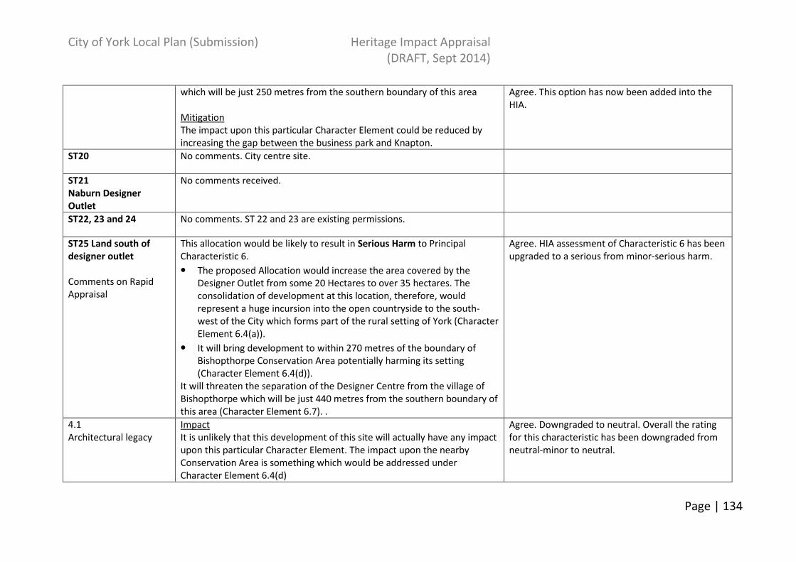
City of York Local Plan (Submission) Heritage Impact Appraisal
(DRAFT, Sept 2014)
Page | 134
which will be just 250 metres from the southern boundary of this area
Mitigation
The impact upon this particular Character Element could be reduced by
increasing the gap between the business park and Knapton.
Agree. This option has now been added into the
HIA.
ST20 No comments. City centre site.
ST21
Naburn Designer
Outlet
No comments received.
ST22, 23 and 24 No comments. ST 22 and 23 are existing permissions.
ST25 Land south of
designer outlet
Comments on Rapid
Appraisal
This allocation would be likely to result in Serious Harm to Principal
Characteristic 6.
• The proposed Allocation would increase the area covered by the
Designer Outlet from some 20 Hectares to over 35 hectares. The
consolidation of development at this location, therefore, would
represent a huge incursion into the open countryside to the south-
west of the City which forms part of the rural setting of York (Character
Element 6.4(a)).
• It will bring development to within 270 metres of the boundary of
Bishopthorpe Conservation Area potentially harming its setting
(Character Element 6.4(d)).
It will threaten the separation of the Designer Centre from the village of
Bishopthorpe which will be just 440 metres from the southern boundary of
this area (Character Element 6.7). .
Agree. HIA assessment of Characteristic 6 has been
upgraded to a serious from minor-serious harm.
4.1
Architectural legacy
Impact
It is unlikely that this development of this site will actually have any impact
upon this particular Character Element. The impact upon the nearby
Conservation Area is something which would be addressed under
Character Element 6.4(d)
Agree. Downgraded to neutral. Overall the rating
for this characteristic has been downgraded from
neutral-minor to neutral.
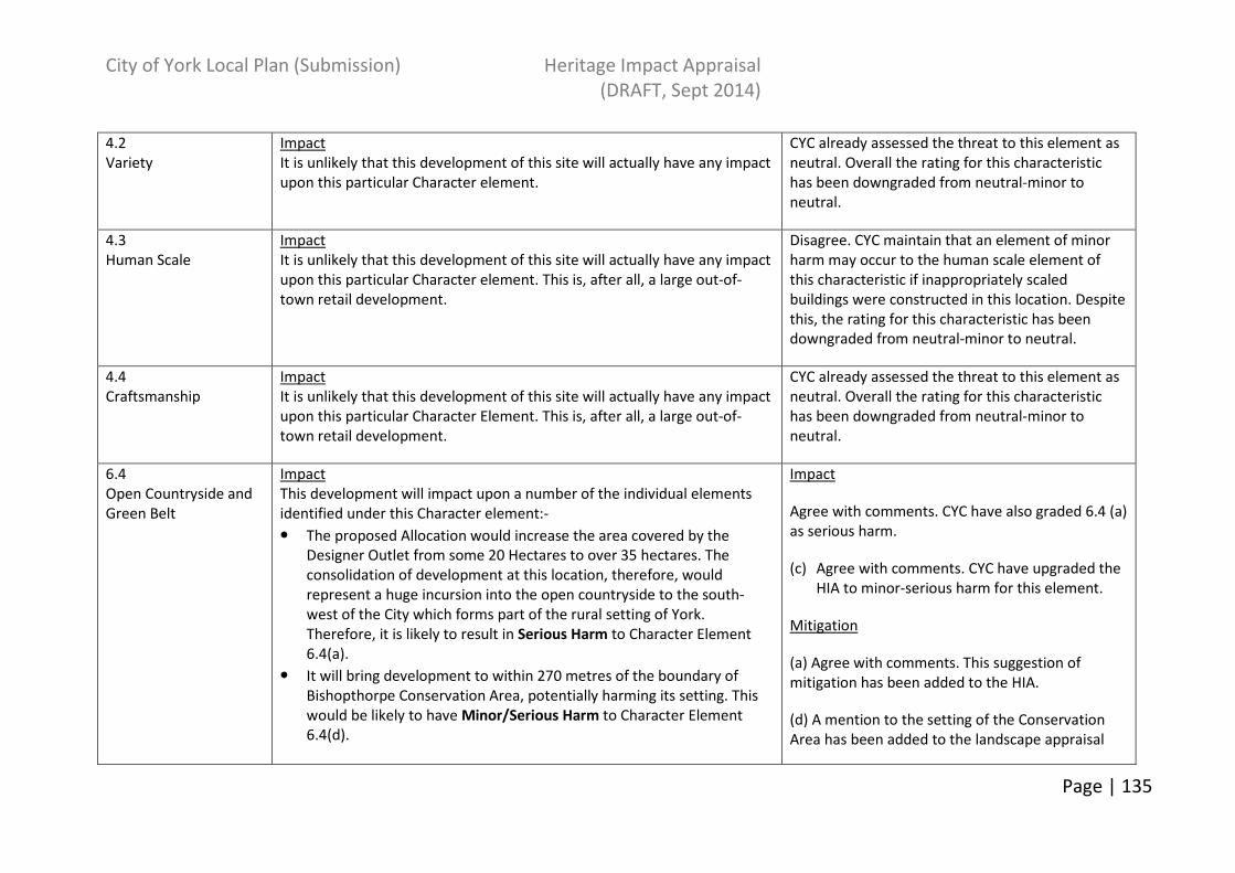
City of York Local Plan (Submission) Heritage Impact Appraisal
(DRAFT, Sept 2014)
Page | 135
4.2
Variety
Impact
It is unlikely that this development of this site will actually have any impact
upon this particular Character element.
CYC already assessed the threat to this element as
neutral. Overall the rating for this characteristic
has been downgraded from neutral-minor to
neutral.
4.3
Human Scale
Impact
It is unlikely that this development of this site will actually have any impact
upon this particular Character element. This is, after all, a large out-of-
town retail development.
Disagree. CYC maintain that an element of minor
harm may occur to the human scale element of
this characteristic if inappropriately scaled
buildings were constructed in this location. Despite
this, the rating for this characteristic has been
downgraded from neutral-minor to neutral.
4.4
Craftsmanship
Impact
It is unlikely that this development of this site will actually have any impact
upon this particular Character Element. This is, after all, a large out-of-
town retail development.
CYC already assessed the threat to this element as
neutral. Overall the rating for this characteristic
has been downgraded from neutral-minor to
neutral.
6.4
Open Countryside and
Green Belt
Impact
This development will impact upon a number of the individual elements
identified under this Character element:-
• The proposed Allocation would increase the area covered by the
Designer Outlet from some 20 Hectares to over 35 hectares. The
consolidation of development at this location, therefore, would
represent a huge incursion into the open countryside to the south-
west of the City which forms part of the rural setting of York.
Therefore, it is likely to result in Serious Harm to Character Element
6.4(a).
• It will bring development to within 270 metres of the boundary of
Bishopthorpe Conservation Area, potentially harming its setting. This
would be likely to have Minor/Serious Harm to Character Element
6.4(d).
Impact
Agree with comments. CYC have also graded 6.4 (a)
as serious harm.
(c) Agree with comments. CYC have upgraded the
HIA to minor-serious harm for this element.
Mitigation
(a) Agree with comments. This suggestion of
mitigation has been added to the HIA.
(d) A mention to the setting of the Conservation
Area has been added to the landscape appraisal

City of York Local Plan (Submission) Heritage Impact Appraisal
(DRAFT, Sept 2014)
Page | 136
Mitigation
• The harm to Character Element 6.4(a) could be mitigated by reducing
the extent of this allocation.
• The way to reduce the harm to Character Element 6.4(d) is to ensure
that the rural setting of the Conservation Area is not harmed. The
Council has a statutory duty under the provisions of the Planning
(Listed Buildings and Conservation Areas) Act, 1990 to pay “special
attention” to “the desirability of preserving or enhancing the character
or appearance” of its Conservation Areas. Consequently, before
allocating this area for development there will need to be some
evaluation of the contribution which this currently-open area makes to
the setting of the Conservation Area and an assessment of what
impact its loss and subsequent development might have upon the
character of the Conservation Area.
mitigation measure suggested in the HIA.
6.7
Relationship of York to
surrounding villages
Impact
Development of this site in its current form would be likely to result in
Minor Harm to this character Element since it will reduce the distance
between the Designer Outlet and the village of Bishopthorpe.
Mitigation
The impact upon this particular Character Element could be reduced by
increasing the gap between the Designer Outlet and Bishopthorpe.
CYC HIA already reflected comments on both
impact and mitigation.
ST26-30 Site comments received as part of FSC.