annex e: field survey for problem identificationopen_jicareport.jica.go.jp/pdf/11674785_07.pdf ·...
TRANSCRIPT

Annex E:
Field Survey for Problem Identification
Table of Contents
E.1 Selection of Detailed Survey Kabupaten ---------------------------------------------- E - 1
E.1.1 Necessity of Provincial Categorization ------------------------------------ E - 1
E.1.2 Used Indicators---------------------------------------------------------------- E - 1
E.1.3 Screening Parameters Used-------------------------------------------------- E - 2
E.1.4 Site Selection ------------------------------------------------------------------ E - 2
E.2 Biophysical Conditions of RRA Survey Area----------------------------------------- E - 5
E.3 WUA Questionnaire Survey Area ------------------------------------------------------ E - 14

List of Tables
Table E.1.1 Categorization of kabupaten in West Sumatera ------------------------- E - 15 Table E.1.2 Categorization of kabupaten in West Java--------------------------------- E - 15 Table E.1.3 Categorization of kabupaten in Yogyakarta ------------------------------- E - 16 Table E.1.4 Categorization of kabupaten in East Java --------------------------------- E - 16 Table E.1.5 Categorization of kabupaten in West Nusa Tenggara -------------------- E - 17 Table E.2.1 Results of RRA Survey on Farmers’ Perspective in W. Sumatera ----- E - 17 Table E.2.2 Results of RRA Survey on Farmers’ Perspective in W. Java ----------- E - 18 Table E.2.3 Results of RRA Survey on Farmers’ Perspective in Yogya. ------------ E - 19 Table E.2.4 Results of RRA Survey on Farmers’ Perspective in E. Java------------ E - 20 Table E.2.5 Results of RRA Survey on Farmers’ Perspective in NTB -------------- E - 20 Table E.3.1 List of Selected Questionnaire Survey WUA Area in W. Sumatera --- E - 21 Table E.3.2 List of Selected Questionnaire Survey WUA Area in W. Java --------- E - 23 Table E.3.3 List of Selected Questionnaire Survey WUA Area in Yogyakarta----- E - 25 Table E.3.4 List of Selected Questionnaire Survey WUA Area in E. Java---------- E - 26 Table E.3.5 List of Selected Questionnaire Survey WUA Area in NTB ------------ E - 28
List of Figures
Fig. E.1.1 Selected Kabupaten in West Sumatera------------------------------------- E - 29 Fig. E.1.2 Selected Kabupaten in West Java------------------------------------------- E - 29 Fig. E.1.3 Selected Kabupaten in Yogyakarta ----------------------------------------- E - 30 Fig. E.1.4 Selected Kabupaten in East Java-------------------------------------------- E - 30 Fig. E.1.5 Selected Kabupaten in West Nusa Tenggara ------------------------------ E - 31 Fig. E.2.1 Transect of RRA WUA Areas ---------------------------------------------- E - 31 Fig. E.2.2 Transect of Mekar Jaya WUA Area in West Java ------------------------ E - 32 Fig. E.2.3 Transect of Dewi Sri WUA Area in West Java --------------------------- E - 32 Fig. E.2.4 Transect of Tani Mukuti WUA Area in West Java ----------------------- E - 33 Fig. E.2.5 Transect of Kelompok Tani WUA Area in West Java ------------------- E - 33 Fig. E.2.6 Transect of Mugia-Mulya WUA Area in West Java --------------------- E - 34 Fig. E.2.7 Transect of Among Mitro WUA in Yogyakarta -------------------------- E - 34 Fig. E.2.8 Transact of Desa Sumber Salak Kab. Jember, in East Java ------------- E - 35 Fig. E.2.9 Transact of Sumbar Makmur WUA, in East Java ------------------------ E - 35 Fig. E.2.10 Transact of Tani Harapan Tirto Makumur Area , in East Java---------- E - 36 Fig. E.2.11 Transact of Tirto Agung Area, in East Java ------------------------------- E - 36 Fig. E.2.12 Transact of Trang Makumur WUA Area, in East Java ------------------ E - 37 Fig. E.2.13 Transact of Tirto Wono WUA Area, in East Java ------------------------ E - 37 Fig. E.2.14 Transect of Labulia WUA Area in NTB----------------------------------- E - 38 Fig. E.2.15 Transect of Bagik Papan Village, East Lombok, NTB------------------- E - 38 Fig. E.2.16 Transect of Rontu Village, Bima Distric in NTB------------------------- E - 39

E - 1
SITE SELECTION
Ethnicity?Density?Sawah?SWS?Elevation?
SelectedKabupaten
No
PU?non-PU?WUA?No WUA?Same project?
SelectedDI
NoBB, SB, B?Hilir, tengah, hulu?
SelectedWUA
PROVINCE
No
Yes
SelectedKabupatenSelected
KabupatenSelectedKabupaten
SelectedKabupaten
Yes
SelectedDI
SelectedDI
Yes
SelectedWUASelected
WUASelectedWUASelected
WUASelected
WUA
E.1 Selection of Detailed Survey Kabupaten
E.1.1 Necessity of Provincial Categorization
It was important to ensure the adequacy of surveyed locations in the five Study Provinces for field data collection and analysis, to achieve the study objectives and expected results of the Phase-I Study, in particular. Accordingly the surveyed locations of the five Study Provinces needed to cover the wide range of irrigation management and WUA conditions which are found.
E.1.2 Used Indicators
For categorization purposes, secondary data, available at provincial and district levels, regarding the following factors were collated and examined.
a) Ethnical group distribution, to indicate the prevailing socio-cultural characteristics of local farmers that might affect their irrigation management and WUA practices.
b) Rural population density (people per km2), to indicate the extent of regional development progress that may affect the local farmers’ behaviour and, in turn, affect their irrigation management and WUA practices.
c) Sawah and non-sawah landuse (ha, %), to indicate the extent to which sawah and non-sawah land uses may affect local farmers’ income sources, and hence affect their irrigation management and WUA practices.
d) SWS (river basin unit), to indicate the existing types of water resources used for the local irrigation systems that may affect the irrigation management and WUA practices.
e) Elevation (m.a.s.l, meter above sea level), to indicate the altitude of sawah and non-sawah landuse areas that may affect the local cultivation practice, which may in turn affect the irrigation management and WUA practices.

E - 2
E.1.3 Screening Parameters Used
The screening parameters for the included districts of the five Study Provinces were then established, as summarized below:
Indicator Criteria Code
a) Ethnic group distribution Major ethnic group - 1 Major ethnic group - 2 Major ethnic group - 3
a1 a2 a3
b) Rural population density < 500 people/ km2 500-1000 people/km2 >1000 people/ km2
b1 b2 b3
c) Sawah landuse >50% ha sawah area <50% ha sawah area
c1 c2
d) SWS distribution (river basin unit) SWS – 1 SWS – 2 SWS - 3
d1 d2 d3
e) Elevation classification
<100 masl>50% area 100-500 masl >50% ha area >500 masl <50% ha area
e1 e2 e3
The categorization of Kabupatens in each Study Provinces are shown in Table E.1.1 to E.1.5. E.1.4 Site Selection
(1) Selection Procedure
This study employed two complimentary approaches: Quantitative and Qualitative. Quantitative approach is aimed to describe general conditions of agricultural activities and irrigation system and management in the study areas. While qualitative approach is directed to deeply investigate the qualitative aspects (such as historical, process, aspiration, etc.) of the above conditions. The quantitative approach is conducted through a sample survey, whereas the qualitative one is carried out using RRA techniques. Combination of the two approaches is also aimed to facilitate triangulation in order to yield data of higher quality. Besides these two approaches, this study also collected secondary data from various related institution at different levels, from village level up to provincial level. Unit of analysis of this study included: 1) farm households which function as a farming production unit and as a member of WUA, 2) Water Users’ Association as an institution. Hence, sample of the study will included individual households and WUAs. A WUA sample was drawn through two stage selection procedure:
Stage 1: Selection of districts which represented variety of indicators such as major ethnic groups, river basin unit (or SWS – satuan wilayah sungai), population density, percentage area of paddy field, and altitude. Three out of five indicators showed significant variations among the selected districts. The result of the district selection in West Sumatra is presented in the following table.
Stage 2: Six out of seven selected districts selected in Stage 1 were decided to be the location for RRA. One WUA within each district was selected based on the following characteristics: area coverage of the irrigation system which varies from <150 Ha, 150-500 Ha, and >500 Ha; WUA’s stage of development which varies from underdeveloped, developing, and developed; and other applicable aspects. The result of the WUA selection is presented in the following table
A household sample was drawn from the sampled WUAs. Within a sampled WUA, 3 households were selected to represent farm household at upper, middle, and down stream of the irrigation system to be

E - 3
interviewed with the institutional aspects of the WUA’s management. Two out of the 3 households were subsequently interviewed with general farm aspects. (2) West Sumatera
The following table indicated differentials in some major indicators among selected districts in West Sumatera which was expected to represent the variations of the indicators in the province.
Selected Districts With Criteria In West Sumatra Province
No Districts Major Ethnic SWS Altitude
1 Pesisir Selatan Minang Silaut, Batanghari >50% area >100 m asl 2 Solok Minang Indragiri, Silaut, Anai Sual
and Batanghari >50% area >100 m asl
3 Sawahlunto/Sijunjung Minang Indragiri , Batanghari` >50% area >100 m asl 4 Padang/Pariaman Minang and Mentawai Indragiri, Silaut, Anai Sual >50% area <100 m asl 5 Agam Minang Indragiri, Anai Sual >50% area >100 m asl 6 50 Kota Minang Indragiri, Anai Sual >50% area >100 m asl 7 Pasaman Minang Anai Sual >50% area >100 m asl
Selected WUAs with Criteria for RRA in West Sumatra
No Sub-district/District WUA/Village/ Area of coverage (Ha)
Type of Irrigation System
WUAs’ level of development
1 Batu Asahan Indah/Koto Pulai/ Tarusan/Pesisir Selatan 25 Semi-technical Under-developed
2 lam Lestari/ Maju Singkarak dan Sumani/Kota Singkarak/ Solok 146 Technical Developed
3 Karajosamo/BukitSabalah/ Tanjung Gadang/Sawahlunto Sijunjung 15 Semi-technical Under-developed
4 Tuah Sakato/ Lohong/ Sungai Limau/Padang Pariaman 15 Traditional Developed
5 Tompek Harapan/ Tapian Kandis/Palembayan/Agam 35 Semi-technical Under-developed
6 Taratak/Napar/Payakumbuh Utara/ 50 Kota 55 Semi-technical Developed (3) West Java
The following table indicated differentials in some major indicators among selected districts in West Java which was expected to represent the variations of the indicators in the province. Selected districts with criteria in West Java Province
DISTRICTS MAJOR ETHNIC SWS SOCIO-ECONOMIC
ZONE MANAGING
INSTITUTION
Bogor Banten Ciujung, Cisadane, Cisadea, Citarum Botabek PU
Tangerang Banten Cisadane Botabek PU
Indramayu Cirebon Citarum Utara PU/POJ
Karawang Sunda Citarum Utara POJ
Serang Banten Ciujung, Cisadane Utara PU
Garut Sunda Cimanuk, Ciwulan, Citanduy Selatan PU
Tasikmalaya Sunda Ciwulan, Citanduy Selatan PU
Lebak Banten Ciujung, Cisadane, Cisadea Selatan PU
Cianjur Sunda Cisadea, Citarum, Citanduy Selatan PU
Bandung Sunda Cisadea, Citarum, Cimanuk, Ciwulan Tengah PU
In West Java Province, WUA selection was based on the following characteristics: area coverage of WUA, ethnic group, area coverage, position of WUA in the irrigation scheme, WUA’s level of development, and type of irrigation. The selected WUAs from each sample districts are as follows:

E - 4
Selected WUAs with Criteria for Rapid Rural Appraisals in West Java Province
NAME OF WUA LOCATION OF WUA AREA OF
COVER-AGE ETHNIC GROUPS
POSITION OF WUA
LEVEL OF DEVELOPMENT TYPE OF IRRIGATION
Sinar maju Pasirtangkil, WarunggunungLebak
< 150 Banten Up-stream Developed Village irrigation
Mekar Jaya Situudik, Leuwiliang, Bogor > 500 Sunda Middle stream Developing Technical irrigation Dewi Sri Sukamaju, Karawang > 500 Sunda Down stream Developing Technical irrigation Tani Mukti Bogor, Indramayu > 500 Cirebon Down stream Developing Technical irrigation Kelompok tani
Rancatungku, Bandung > 500 Sunda Down stream Developing Technical irrigation
Mugia-mulya Desa Cigalontang, Tasikmalaya
150 –250 Sunda Down stream Under-developed Semi-technical irrigation
(4) DI. Yogyakarta
District selection in DIY was based on three major indicators: area of WUA, type of irrigation system, and number of WUAs
Selected districts with criteria in DIY Province DISTRICTS AREA OF WUA NAME OF DRAIN
INLET TYPE OF
IRRIGATION SYSTEM NUMBER OF
WUAS Gunung Kidul < 150 Ha Garotan Barat Traditional No WUA Bantul 150 – 500 Ha Mejing Technical Several WUAs Sleman < 150 Ha Gayam Traditional 1 WUA
District selection in DIY was based on three major indicators: area of WUA, type of irrigation system, and number of WUAs
Selected WUAs with Criteria for Rapid Rural Appraisals in D I Yogyakarta Province NAME OF
WUA LOCATION OF WUA AREA OF COVERAGE
POSITION OF WUA TYPE OF WUA TYPE OF
IRRIGATION
Garotan Barat Desa Bendung, Kec. Semin, Kab. Gn. Kidul < 150 Hulu No WUA Village
Irrigation
Satuhu Kec. Bambang Lipuro, Kab. Bantul 150 - 500 Hulu,
Tengah, dan Hilir Several WUA (WUAF)
Technical Irrigation
Among Mitro Desa Umbul Martani, Kec. Ngemplak, Kab. Sleman < 150 Hilir 1 WUA Technical
Irrigation (5) East Java
In East Java Province sample districts were selected based on the following aspects: Major ethnic group, position of WUA in the scheme, and number of WUAs
Selected districts with criteria in East Java Province
ETHNIC NO DISTRICT
1 2 POSITION NUMBER OF WUAS
1 Jember Jawa Madura Up Non WUA 2 Pasuruan Jawa Down 1 WUA 3 Jombang Jawa Middle Several WUA 4 Banyuwangi Jawa Osing Up No WUA 5 Sumenep Madura Down 1 WUA 6 Bojonegoro Jawa Middle Several WUA 7 Kediri Jawa 8 Lumajang Jawa 9 Malang Jawa 10 Trenggalek Jawa
E - 5
Selected WUAs with Criteria for Rapid Rural Appraisals in East Java Province NAME OF
WUA LOCATION OF WUA AREA OF COVER-AGE
ETHNIC GROUPS
POSITION OF WUA
LEVEL OF DEVELOPMENT
TYPE OF IRRIGATION
Non-WUA Desa Sumber Salak, Kec. Ledokombo, Kab. Jember
150-500 Ha
Jawa, Madura Up-stream Under-develope
d -
Sumber Makmur
Desa Kejayan, Kec. Kejayan, Kab. Pasuruan < 150 Ha Jawa Down
stream Developing -
Tani Harapan, Tirto Makmur
Desa Diwek dan Ceweng, Kec. Diwek, Kab. Jombang < 150 Ha Jawa Middle
stream - -
Tirto Agung Desa Cantuk, Kec.Singoju-ruh, Kab. Banyuwangi
150-500 Ha
Jawa, Osing
Middle stream
Under-developed -
Talang Makmur
Desa Talang, Kec. Saronggi, Kab. Sumenep < 150 Ha Madura Down
stream Developed -
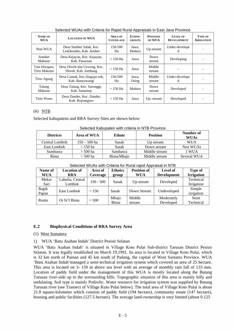
Tirto Wono Desa Dander, Kec. Dander, Kab. Bojonegoro < 150 Ha Jawa Up- stream Developed -
(6) NTB
Selected kabupatens and RRA Survey Sites are shown below:
Selected Kabupaten with criteria in NTB Province
Districts Area of WUA Ethnic Position Number of WUAs
Central Lombok 150 – 500 ha Sasak Up stream WUA East Lombok < 150 ha Sasak Down stream Non WUAs
Sumbawa > 500 ha Sumbawa Middle stream 1 WUA Bima > 500 ha Bima/Mbajo Middle stream Several WUA
Selected WUAs with Criteria for Rural rapid Appraisal in NTB
Name of WUA
Location of RRA
Area of Coverage
Ethnics group
Position of WUA
Level of Development
Type of Irrigation
Mekar Sari
Labulia, Central Lombok 150 - 500 Sasak Up stream Developed Technical
Irrigation Bagik Papan East Lombok < 150 Sasak Down Stream Undeveloped Simple
irrigation
Rontu Oi Si’I Bima > 500 Mbajo /Bima
Middle stream
Moderately Developed
Semi Technical
E.2 Biophysical Conditions of RRA Survey Area
(1) West Sumatera
1) WUA ‘Batu Asahan Indah’ District Pesisir Selatan WUA ‘Batu Asahan Indah’ is situated in Village Koto Pulai Sub-district Tarusan District Pesisir Selatan. It was legally established on March 19,1991. Its area is located in Village Koto Pulai, which is 32 km north of Painan and 45 km south of Padang, the capital of West Sumatra Province. WUA ‘Batu Asahan Indah’managed a semi-technical irrigation system which covered an area of 25 hectare. This area is located on 3- 150 m above sea level with an average of monthly rain fall of 133 mm. Location of paddy field under the management of this WUA is mostly located along the Batang Tarusan river-side up to the sorrounding hills. Topographic situation of this area is mainly hilly and undulating. Soil type is mainly Podzolic. Water resource for irrigation system was supplied by Batang Tarusan river (see Transect of Village Kuto Pulai below). The total area of Village Koto Pulai is about 21.8 square-kilometer which consists of paddy field (194 hectare), community estate (147 hectare), housing and public facilities (127.5 hectare). The average land-ownership is very limited (about 0.125


E - 10
year. The chief of village development affairs (Kaur Pembangunan Desa), and farmers, it was concluded that the wet season starts in November and last until March. Dry season starts in April until October. These facts affected the cropping pattern and its schedule. Based on topography maps (scale of 1:50.000), Gunung Kidul District is Seribu mountain range, undulating with land slopes vary up to 4 classes. DI West Garotan (Bendung Village), is at 184 m amsl (above mean sea level) with a slope of 0 – 2%. The Land-use can be observed in Figure 5.6 and classified as paddy field, dry land, home plot and secondary forest. Field area at DI West Garotan was 36 ha. About 30 ha got water directly from canal while the rest might get water only if water pump was employed since it was above the canal. There were 18 farmers there. Each farmer owned about 0.5 ha. The largest owned plot was 2 ha and the least was 0.5 ha.. At DI West Garotan, irrigation canals were modest and its water source was a small river called Sungai Plutungo (Plutongo River). It was part of Oya river basin. It was a drainage canal for home plots above and obviously, it had no upper region (hulu). Since 1999, main irrigation dam was concreted. The length of jacketed canal was about 40-m, and the rest was still dried ground. The irrigation canals functioned only in wet season whereas during dry season the water didn’t flow. During dry season, farmers brought the water from the dam using gendongan to water their plants. Today, farmers used electric water pump. They supplied the electricity from their homes. It took about 500 m to supply the electricity. The water had to be flown through 200 – 400 m hose to reach the plants. 2) DI Mejing
The area at DI Mejing was about 418.93 ha covering Mulyodadi Village of 175.25 ha, Sidomulyo Village of 241.91 ha, Kecamatan Bambanglipuro and Srihardono Village of 1.77 ha, Kecamatan Pundong, Bantul District. Geographically, it is at 07º 44’04’’ South latitude-110º 12’ 34’’ East longitude to 08º 00’27’’ South latitude-110º 31’ 08’’ East longitude with the following physical conditions: Rainfall data (1990 to 1999) for this area were obtained from Pundong Station, Kecamatan Pundong, which is about 0.7 km from the site of study. Based on primary map (scale of 1:50.000), topography of this region ranged from hilly part, low land to coastal area varied at 5 classes spatial altitude as seen in Appendices. As seen in Table 5.9, the largest area was at 25 – 100 m above mean sea level. This part was in the northern part of the region. The area of DI Mejing was at 7-m above sea level, near the beach. It was obvious that there were 6 classes of slope spatially as represented in Table 5.10 and in Appendices. Based on topographic condition, Land-use of this region were for paddy fields, dry land, home plot and secondary forest. Slope at DI Mejing (7 m above mean sea level) was about 0 to 2%. Land-use were paddy field and dry land as seen in transect. Since this region was quite large and the physical condition of the soil was rather different, there were three transects built. The first transect was at the upper region (WUA ‘Sidorukun’ at MJ5 Plot), the second was at middle region (WUA ‘Tirtomakmur’, MJ13 plot), and the last one at lower region (WUA ‘Tirto Manunggal’) as seen in the following figure.


E - 13
Cropping Pattern Paddy was planted twice on irrigated paddy fields during wet season in Bantul region. Afterwards, the field was planted with other food crops such as, soybean, peanut, corn, chili and sugar cane. Therefore, planting started in November until March. The cropping pattern in Mejing area was similar to that in Bantul region. However, since the area was quite large, there were three different cropping patterns namely:
a) Type I (upper region), fields got enough water and the cropping pattern was paddy–paddy -other food crops.
b) Type II (middle region), Water availability was not enough to plant paddy twice. Therefore, the cropping pattern was as follows. All farmers planted paddy at the beginning of wet season. Then, some farmers planted paddy while some other planted other food crops. When dry season started, farmers planted other food crops.
c) Type III (lower region), unlike the other two parts, this region got the least water and the soil was porous since it was close to coastal area. In this region, paddy was planted at the beginning of wet season, then it follows by other food crops.
Based on these cropping patterns, the farmers planted paddy field while the other food crops were peanut and soybean. Recently, some farmers tried to plant chili peppers and tomato during dry season. 3) DI Gayam
The area at DI Gayam was about 26 ha covering Umbul Martani Village, Kecamatan Ngemplak, Sleman District. Geographically, it is at 07º 34’04’” South latitude -107º 15’ 30” East longitude to 07º 47’30” South latitude -110º 28’ 30” East longitude with the following physical conditions: Rainfall Rainfall data (1990 to 1999) for this area were obtained from Pundong Station, Kecamatan Pundong, which is about 0.7 km from the site of study. There are 4 consecutive wet months in a year starting December to April. There are also several dry months with the average rainy days is 20 days a year. Based on semi-structured interview with several key sources, such as the head of the village (kepala desa), chief of village development affairs (KaUr Pembangunan Desa), and farmers, it is concluded that the wet season starts in November and last until March. Dry season starts in April until October. These facts affected the cropping pattern and its schedule. Topography Based on primary map on a scale of 1:50.000 in Bantul District, there were high land (Merapi hill side) and other 4 classes spatially different areas.It was obvious that the area with 100 – 499 m amsl was the largest and in the northern part of the region. DI Gayam region was at 210 m amsl, with the slope of 2 to 5%, in the hill side of Merapi Mount. According to topographic conditions, land-uses were paddy field, dry land, home plot, and secondary forest. Soil In general, there were 4 types of soil namely, Litosol, Regosol, Grumusol, and Mediteran. Irrigated area tended to have Regosol type of soil. According to Darmawidjaya (1970) in Jauhari (1996), this soil is crumb soil with sandy loam texture, well drained, easily entrap the water, low erodibility, with solum thickness of 95 – 120 cm. It is affected by young volcanic sediment. The study also reveals that fertilizers utilization was quite high at the amount of: 1) TSP/SP3 = 150 Kg/ha; 2) Urea = 200 Kg/ha; 3) ZA = 100 Kg/ha. In addition, another kind of fertilizer, such as animal manure, was also applied. River Basin Area There were two DAS (river basin areas) namely DAS Progon and DAS Opak which provided several sub-DAS (S. Krasak, S. Bulu, S. Putih, S. Pakem, S. Sarang, S. Konteng, S. Bedog, S. Dengung, S.

E - 14
Boyong, S. Opak, S. Winongo, S. Pelang, S. Buntung, S. Klanduhan, S. Sembung, S. Kuning, S. Tepus, S. Gawe, S. Gede) flowing from the northern part to the southern part. Besides irrigating the agriculture plots, water from these rivers was also used for other needs. Land Utilization Generally, Land-use in Sleman District were for home yard, paddy field, dry land, secondary forest, bare land, bushes, and others such as for cemetery, rivers and roads Land-Size There were 38 ha paddy field in DI Gayam with 48 farmers. Therefore, the average land ownership is about 0.79 ha/farmer. The least plot owned by one farmer was 0.3 ha while the largest was two ha. Water Supplies DI Gayam is village irrigation system having only one WUA called ‘Among Mitro’. Water comes from Gede River, which is a sub-DAS Opak stemmed from Merapi Mount. The main construction is concrete with the length of around 1.5 km. Cropping Pattern Generally in Sleman region, the cropping pattern is as follows. Paddy field is cultivated twice in irrigated fields during wet season from October to March followed by other food crops such as soybean, peanut, and corn. They planted paddy field, peanut and soybean. Recently, there was an attempt to improve the farmer income by crop diversification, such as chili and tomato during dry season. (4) East Java
Transect of RRA WUA area, Desa Sumber Salak, Sumber Makumur, Tani Harapan/Tiro Makumur, Tirto Agung, Talan Makumur and Tirto Wono, are shown in Fig. E.2.8 to E.2.13. (5) NTB
Transect of RRA WUA area of Makar Sari, Bagik Papan and Rontu are shown in Fig. E.2.14 to E.2.16. E.3 WUA Questionnaire Survey Area
The WUA Questionnaire Survey Site in each provinces are shown in Table E.3.1 to E.3.5.

E - 15
Table E.1.1 Categorization of Kabupaten in West Sumatera Province
Table E.1.2 Categorization of Kabupaten in West Java Province

E - 16
Table E.1.3 Categorization of Kabupaten in DI Yogyakarta Province
Table E.1.4 Categorization of Kabupaten in East Java Province

E - 17
Table E.1.5 Categorization of Kabupaten in West Nusa Tenggara Province
Table E.2.1 Results of RRA Survey concerning Farmers’ Perspectives in West Sumatera Province
No. Kodya/Kabupaten
Kecamatan Desa/Kelurahan
No. WUA, status
Name of WUA Main issues/problems
1 Agam Palembayan Tapian Kandis
1 Tompek Harapan
• No rules concerning water management/allocation; officials not active. • Farmers do not feel they are part of WUA. • Extension guidance lacking.
2 Kodya Payakumbuh Payakumbuh Utara Napar
1 Taratak • Tertiary canal broken and cracked, and operation and maintenance along secondary and tertiary canals not optimal; results in leakages and water shortages
• No coordination between different WUAs in irrigation system, results in poor water allocation.
• WUA officials not active; human resources not optimal. • Water demand for each WUA not clear. • Farmers do not feel they are part of WUA, and are not motivated. • No rules concerning water use and water charges, and extension
guidance is not coordinated. 3 Padang Pariaman
Sungai Limau Lohong
1, reverted back to traditional system.
Tuah Sakato
• Responsibilities for irrigation management not clear, causes conflict over water allocation if dry season is long.
• WUA and officials not active; reverted back to traditional organization.
• Farmers do not feel they are part of WUA and are not motivated; incomes too low.
• Extension guidance not well planned and is very infrequent. 4 Solok
Sepuluh Koto Singkarak Maju Singkarak Sumani
1 Alam Lestari
• Secondary canal broken in many places, causes water losses. • Cropping plan is not well implemented and water demands for each
block are not calculated; blocks differ in size. • Farmers are not prepared to pay operational charge, resulting in no
budget to run the pumps • No sanctions for farmers who do not pay water charges. • Human resources low. • Extension guidance is not well planned and is too sporadic.
5 Sawah Lunto Sijungjung Tanjung Gadang Bukit Sabala
1 Karojo Samo
• Water in short supply, especially during dry season, causes conflicts over distribution of water and failed harvests.
• WUA officials not active. • O&M is piecemeal. • Farmers do not feel they are part of WUA and are not motivated;
incomes too low. • Extension guidance is not well planned and is too sporadic.
6 Pesisir Selatan Sebelas Koto Tarusan Koto Pulai
1 Batu Asahan
• Weir and canals broken; O&M not optimal. • Water allocation and water management rules are not clear; some areas
do not receive water. • WUA officials not active; human resources not optimal. • Farmers not involved in O&M decisions and are not prepared to pay
operational charge; incomes too low • Extension guidance not coordinated and is not well planned.

E - 18
Table E.2.2 Results of RRA Survey concerning Farmers’ Perspectives in West Java Province (1/2)
No. Kodya/Kabupaten
Kecamatan Desa/Kelurahan
No. WUA, status
Name of WUA Main issues/problems
1 Lebak Warunggunug Pasir Tangkil
Being developed, village scheme <150 ha
Sinar Maju • Ranking of main problems: 1. many leaks from weir gates and canals; 2. division/off-take gates broken; 3. water insufficient during dry season; 4. many farmers do not pay water charge/not able to pay; 5. input prices not in balance with gabah price.
• Mid-stream and downstream areas receive small flow, experience water shortages in dry season.
• O&M not optimal, farmers not able to pay for high cost of maintenance because production from sawah is low, farmers consider that Government should be responsible for maintenance/repair.
2 Bogor Cibungbulang Situ Udik
Being developed, technical scheme >500 ha
Mekar Jaya • Ranking of main problems: 1. crop pests; 2. low price of padi; 3. inactivity of extension officials; 4. farmers do not want to maintain canals because they feel canals do
not belong to them; 5. all field channels leak, water not distributed smoothly.
• Water gates broken, replaced by bamboo – this affects water availability. • Water is also used for livestock and fisheries — this causes water
allocation problems. • Knowledge about O&M and water charge responsibilities is still low,
budget for maintenance not available (water charge not paid), farmers consider that Government should be responsible for maintenance.
3 Karawang Jatisari Sukamekar
Being developed, technical scheme >500 ha
Dewi Sri • Water is increasingly harder to obtain, particularly in downstream area (far from source); some people get water from pumps.
• O&M dependent on WUA; if farmer pays water charge he does not want to participate in gotong royong for maintenance.
• Many canals leak, canals built by contractors quickly break. • Ulu-ulu/block heads not satisfactory. • Water charge revenue about 60%, not well organized. • Farmers who live outside village not disciplined in paying, • Income of farmers is low (low price of gabah); input costs not in balance
with gabah price. • Farmers complain there are too many taxes levied by village government.
4 Bandung Pameungpeuk Rancatungku
Being developed, technical scheme >500 ha (previous WUA failed in 1984)
Kelompok Tani
• Ranking of main problems: 1. leaks from canals; 2. water shortages in downstream part; 3. seeds not available; 4. wages for labour are high; 5. fertilizer is expensive.
• Annual floods. • Water is increasingly harder to obtain because of competition for water
from PDAM and industry; pollution from industrial effluents. • Many leakages along several canals. • Water distribution is not uniform in downstream area. • O&M is not optimal; only some farmers near canals help with
maintenance. • Canals built by PU (contractors) not used because of poor quality (quickly
break) and are not in accordance with farmers’ wishes; such canals have many rat holes.
• Ulu-ulu not diligent, even though he has received some payment (stipend). • Water charge not organized, only collected when there is a need for canal
repair; farmers do not want to pay water charge again because ulu-ulu is not diligent.
• Farmers who live outside village are generally not disciplined in paying water charge.
• Farmers’ income relatively low, and sawah area is small; input costs not in balance with gabah price.
• Farmers complain there are too many taxes levied by village government.

E - 19
Table E.2.2 Results of RRA Survey concerning Farmers’ Perspectives in West Java Province (2/2)
No. Kodya/Kabupaten
Kecamatan Desa/Kelurahan
No. WUA, status
Name of WUA Main issues/problems
5 Indramayu Sukra Bogor
Being developed, technical scheme >500 ha
Tani Mukti • Farmer income is low because of high cost of inputs, low price of gabah, rats and non-functioning KUD.
• During dry season sometimes water supply not enough, especially in downstream area, depends on juru pengairan.
• Parts of sawah can never get dry because irrigation canal never made dry at certain periods, schedule for drying not right – because of collusion between juru pengairan (PU) and duck farmers; farmers suffer as a result.
• Water distribution not uniform on one of the blocks of sawah. • Maintenance of secondary canals not optimal, canals getting narrower,
water getting less. • Collection of water charge not in order; a small number of farmers do not
want to pay water charge for ulu-ulu. • Conflict between duck farmers and sawah farmers. • Farmers do not want to contribute to gotong royong for canal repair,
ulu-ulu and block heads cannot repair/maintain canals because of limited labour and funds.
6 Tasikmalaya Cigalontang Sirnaputra
Not yet developed, semi-technical scheme 150-200 ha
Mugiamulya • Natural forest replaced by pine trees, results in droughts in dry season and floods in wet season; if there is no rain for 7 days, there is no irrigation water.
• Canal has been pierced in many places and is broken, so water is uncontrolled (often there is no water in midstream and downstream areas), division gates too high.
• Gotong royong happens for major repairs like landslides (which happen often).
• There are many fish ponds, no payments for water. • Water charge for andir is too small, only 20% of farmers pay water
charge. • Ranking of main problems: 1. canal dries up if there is no rain for a week;
2. collapse of canal banks causes closures; 3. most farmers do not pay water charge, income too low; 4. pine trees (in catchment area) are thought to cause droughts; 5. canal from Ciparai does not yet reach the village.
• Not enough financial resources for O&M. • Participation of community is low.
Table E.2.3 Results of RRA Survey concerning Farmers’ Perspectives in DI Yogyarata Province
No. Kodya/Kabupaten
Kecamatan Desa/Kelurahan
No. WUA, status Name of WUA Main issues/problems
1 Sleman Ngemplak Umbul Martani
1, Gayam irrigation system, 38 ha
Among Mitro
• Water availability limited in dry season (in dry season water is ‘borrowed’ from higher up).
• Sanitation. • Environment. • Crop pests and diseases. • Farmers are poor. • Commercial crops not widely developed. • Many canals are not yet lined, some canals leak.
2 Bantul Bambanglipuro/Pundong Sidomulyo/Mulyodadi/Srihardono
WUA federation (10 WUA), DI Meijing, 396 ha
Satuhu (Gabungan P3A Meijing)
• Sanitation. • Environment. • Water availability limited in downstream area. • Some canals are broken, and leak. • Soil is very porous (sandy) in downstream part. • Crop pests and diseases. • Credit not smooth (being developed). • Farmers are poor, farm holdings are very small. • Difficult to find organic fertilizer. • Commercial crops not widely developed.
3 Gunung Kidul Siman Bendung
No WUA (being developed), Garotan Barat village scheme 36 ha
- • Water availability from spring source is limited. • Conveyance canal not optimal. • Erosion. • Salinity. • Threat of land becoming non-arable. • Crop pests and diseases. • Supply of agricultural inputs not smooth, difficult to find organic fertilizer,
place to buy seeds is far away, pesticides are expensive. • Farmers are poor. • Commercial crops not widely developed.

E - 20
Table E.2.4 Results of RRA Survey concerning Farmers’ Perspectives in East Java Province
No. Kodya/Kabupaten
Kecamatan Desa/Kelurahan
No. WUA, status Name of WUA Main issues/problems
1 Bojonegoro Dander Dander
> 1 Tirto Wono • Shortage of water (dry season), due to deforestation in watershed, use of source (spring) also for domestic supply, and abstraction by pumps in upstream part.
• Floods in wet season, caused by deforestation. Effects of deforestation felt from 1960s.
• Broken canals and siltation, causing leaks and distribution problems; canals break quickly because they are also used for other purposes (bathing, washing, toilet) and nobody takes care.
• Water shortages most felt in downstream part (no water at all) and downstream farmers are suspicious of those upstream (some of whom abstract water from canals by pumps). Downstream farmers mainly rely on rainfall for crops.
• Land in upstream part higher than water level in canal (poor canal design). • Farmers are reluctant to pay water charge, particularly in downstream area
because of water shortages and poor condition of irrigation system upstream • Income from water charges insufficient to cover O&M costs. • If farmer pays water charge, consider WUA is responsible for O&M; there is
no incentive to assist with maintenance (gotong royong). • Farmers have no ‘sense of ownership’ of irrigation infrastructure.
2 Jombang Diwek Diwek/Ceweng
>1 (2) a. Tirto Makmur (Ceweng), no longer active (reverted to old system pre-WUA)
b. Tani Harapan (Diwek), become non-active in 1997
• Dry season water shortages (Aug-Oct), causes conflicts. • Relationship of farmers with juru pengairan (government employee) who has
been accused of unfair water management/distribution practices, particularly when water is in short supply (Aug-Oct).
• In some years water is not available when needed. • Poor state of tertiary systems (mostly tenant/sharecropper farmers who don’t
care about maintenance). • Water charge no longer paid, because farmer incomes are low and
unpredictable. • During dry season and sugar cane milling season (Aug-Oct), effluent from
sugar factory (PG Cukir?) is hot and black, affects crops. • There is no division gate at sugar factory discharge to divide flow between
Jatirejo village and Diwek/Ceweng/Balongbesuk villages, and because bottom limit is at different heights much more water flows to Jatirejo.
• WUA not motivated, lack of human resources. 3 Pasuruan
Kejayan Kejayan
1 Sumber Makmur
• Appointment of WUA chairman (newly appointed chairman does not want post and wants to hand back to previous chairman).
• WUA not active in southern part of area which experiences water shortages (Sidorejo) where no water charges collected. Sidorejo farmers do not want to be organized by WUA.
• Water allocation in downstream part. • Canal system in need of repair.
4 Jember Ledokombo Sumber Salak
WUA no longer active
- • Some water shortages in downstream area during dry season. • Sedimentation in canals in downstream area; erosion and flooding. • Farmers in upstream area not active in regulating water (farmers in middle and
downstream parts active). • Water charges are not used for O&M (no attention is given to canals).
5 Banyuwangi Singojuruh Cantuk
1, reactivated Tirto Agung • Water shortages experienced in one small area (Turus Kiri).
6 Sumenep Saronggi Talang
1, mainly for 3 deep wells,
formed cooperative.
Talang Makmur
• Low returns from padi and palawija. • Agricultural inputs expensive, even for tobacco (main source of income). • Canals repaired by Government not in accordance to farmers’ wishes. • No surface water in dry season, floods in wet season (rely on deepwell pumps). • Deepwell pumps getting old.
Table E.2.5 Results of RRA Survey concerning Farmers’ Perspectives in West Nusa Tenggara Province
No.
Kodya/Kabupaten Kecamatan
Desa/Kelurahan No. WUA,
status Name of WUA Main issues/problems
1 Lombok Tengah Jonggat Labulia
>1 (WUA federation)
Mekarsari (in Gabungan P3A Batujai Hilir)
• Located in downstream area of Jurang Sate weir (DI Batujai), water shortages in dry season, conflicts over unequal distribution of water.
• Water service charge collected, but no money available for repair of canals (money used for rehabilitation works in mid-stream and upstream parts of irrigation system).
2 Lombok Timur Pringgabaya Bagik Papan
No WUA - • Water from spring Telaga Murni 50 l/s, also used for PDAM supply. • No water service charge collected.
3 Bima Rasanae Rontu
1 (DI Wawo) Oi Si’I • Water flow insufficient during dry season, especially Aug-Oct. • Headworks is old (Rontu weir), never been rehabilitated; it leaks and is
covered with landslide debris. • Irrigation canal not lined, high infiltration. • Water distribution is not uniform. • No water service charge, farmers not able to pay, hence no funds for
maintenance/repair. • Labour is limited.

Table E.3.1 List of Selected WUA Areas for Questionnaire Survey in West Sumatera Province (1/2)
E - 21

Table E.3.1 List of Selected WUA Areas for Questionnaire Survey in West Sumatera Province (2/2)
E - 22

Table E.3.2 List of Selected WUA Areas for Questionnaire Survey in West Java Province (1/2)
E - 23

Table E.3.2 List of Selected WUA Areas for Questionnaire Survey in West Java Province (2/2)
E - 24

Table E.3.3 List of Selected WUA Areas for Questionnaire Survey in Yogyakarta Province
E - 25
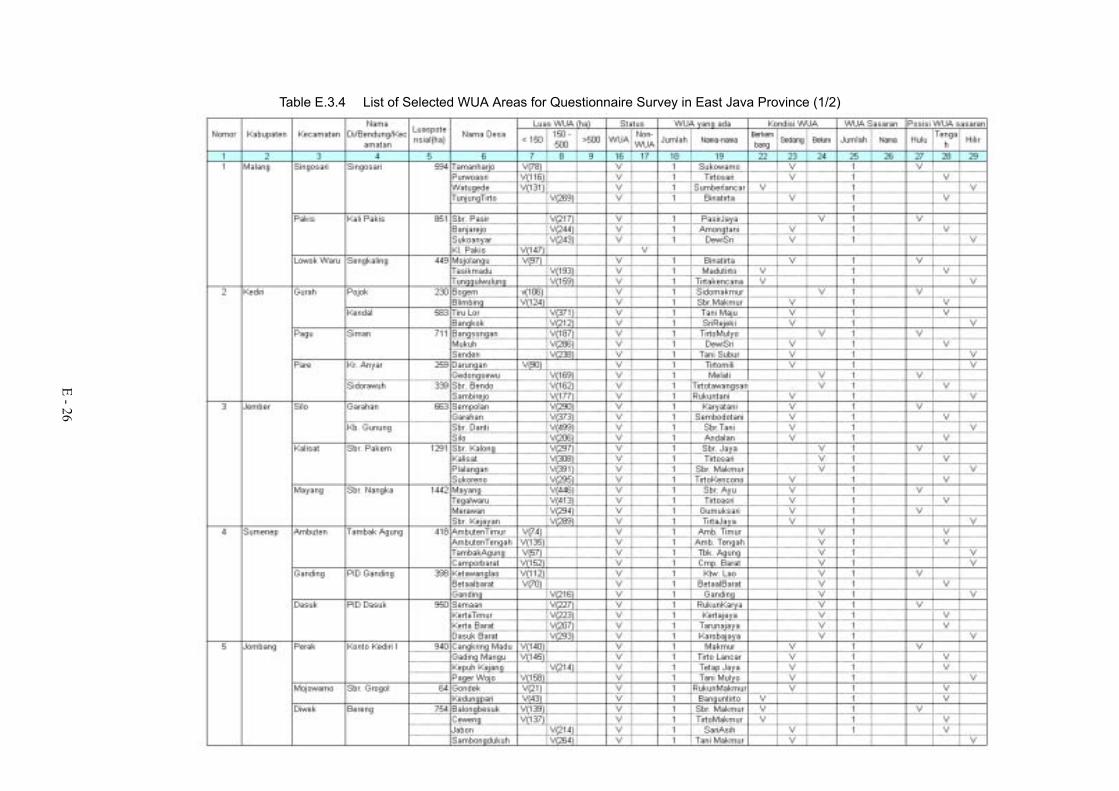
Table E.3.4 List of Selected WUA Areas for Questionnaire Survey in East Java Province (1/2)
E - 26

Table E.3.4 List of Selected WUA Areas for Questionnaire Survey in East Java Province (2/2)
E - 27

Table E.3.5 List of Selected WUA Areas for Questionnaire Survey in NTB Province
E - 28