announcement: $231m boost for state highway 1 in …
TRANSCRIPT

KAIKOURA EARTHQUAKE UPDATE 1
KAIKOURA EARTHQUAKE UPDATEKAIKOURA EARTHQUAKE UPDATE – no. 27 28 July 2017
This weekly bulletin provides the latest information about the rebuild of road and rail networks damaged by the Kaikoura earthquake in November 2016. The bulletin is produced by the North Canterbury Transport Infrastructure Recovery (NCTIR) – an alliance representing the NZ Transport Agency and KiwiRail, on behalf of Government. We’re keen to hear your questions about our work, or any feedback on this bulletin. Drop us a line via email at [email protected] or give us a call on 0800 NCTIREQ (0800 628 4737) – we’d like to hear from you.
In this issue of the Bulletin we feature innovation. The scale and pace of the work to reinstate State Highway 1 and the Main North Line has meant teams working on all aspects of the project have had to think and work differently. From constructing a temporary accommodation village to house workers to mobile testing labs for isolated locations, the teams have worked to find smart solutions to reach the goal of reopening the rail as soon as possible and the road by Christmas.
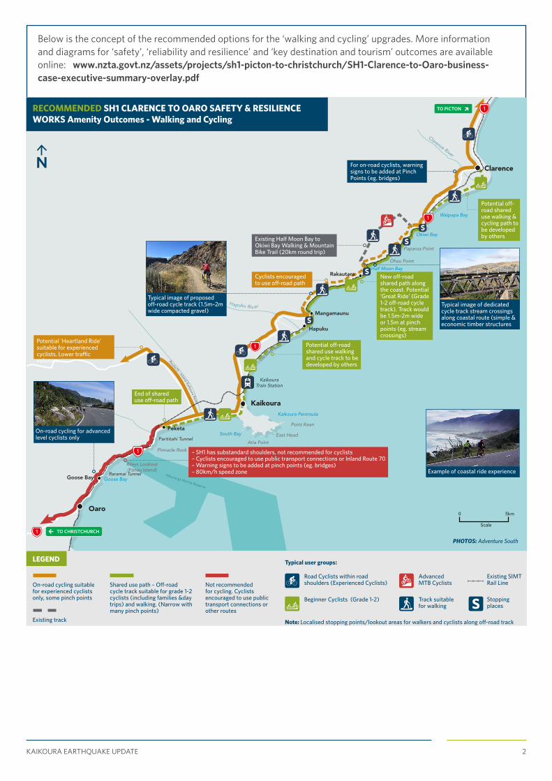
ANNOUNCEMENT: $231M BOOST FOR STATE HIGHWAY 1 IN THE KAIKOURA REGIONA $231 million funding boost was announced this week to improve the 60km section of State Highway 1 between Clarence and Oaro.
The work has been fast-tracked by the NZ Transport Agency, on behalf of the Government, so it can be delivered as part of the earthquake reinstatement work, meaning less disruption for everyone.
The improvements programme will increase safety, resilience, reliability, access and amenity and provide a better experience for locals and visitors using the route.
The improvements programme includes:
• Infrastructure changes including wider road shoulders, additional safety barriers, more passing opportunities, and improved access and stopping areas
• A separated cycle/walk facility between Okiwi Bay and Mangamaunu to provide opportunities for people to enjoy the iconic coastline at a more leisurely pace (see illustration below of recommended cycling track around Ohau)
• Safe and appropriate speed limits (80 km/hr) in the winding sections where operating speeds are already slower and the speed limit reinforces safer driver behaviour
• A shared path and enhanced stopping areas which support tourism and economic recovery, with new digital technologies used to provide safety messages and ‘tell the story’ of the coastal corridor to visitors.
The Transport Agency worked with the Kaikoura earthquake Restoration Liaison Group throughout the development of the concept designs for these coastal improvements. NCTIR will now undertake the detailed design work and will continue to work with this group. For more information visit: www.nzta.govt.nz/picton2chch
North Canterbury TransportInfrastructure Recovery
KAIKOURA EARTHQUAKE UPDATE 2
Below is the concept of the recommended options for the ‘walking and cycling’ upgrades. More information and diagrams for ‘safety’, ‘reliability and resilience’ and ‘key destination and tourism’ outcomes are available online: www.nzta.govt.nz/assets/projects/sh1-picton-to-christchurch/SH1-Clarence-to-Oaro-business-case-executive-summary-overlay.pdf
Hikurangi Marine Reserve
Scale
0 5km
LEGEND
Date: 6 June 2017 Revision: 04
Existing track
Existing SIMT Rail Line
Stopping places
Not recommended for cycling. Cyclists encouraged to use public transport connections or other routes
On-road cycling suitable for experienced cyclists only, some pinch points
Road Cyclists within road shoulders(Experienced Cyclists)
Advanced MTB Cyclists
Note:- Localised stopping points/lookout areas forwalkers and cyclists along off-road track
Track suitable for walking
Beginner Cyclists (Grade 1-2)
Shared use path - Off-road cycle track suitable for grade 1-2 cyclists (including families & day trips) and walking. (Narrow with many pinch points)
S
S
S
S
S
SH1 CLARENCE TO OARO SAFETY & RESILIENCE WORKSAmenity Outcomes - Walking and Cycling
Typical user groups:
DRAFTRileys Lookout(Panau Island)
Paparoa Point
Ohau Point
Pinnacle Rock
Parititahi Tunnel
Raramai Tunnel
Point Kean
East Head
Atia Point
Half Moon Bay
Goose Bay
South Bay
Kaikoura Peninsula
Kaikoura Train Station
Waipapa Bay
Okiwi Bay
Goose Bay
Route70 - Inland Kaikoura Road
Old Bea
ch Road
Hapuku Riv er
Oaro
Kaikoura
Peketa
Mangamaunu
Rakautara
Clarence
Clarence River
Hapuku
1
1
1
1
1
PHOTOS: Adventure South
For on-road cyclists, warning signs to be added at Pinch Points (eg. bridges)
Potential off-road shared use walking & cycling path to be developed by others
Typical image of dedicated cycle track stream crossings along coastal route (simple & economic timber structures
Existing Half Moon Bay to Okiwi Bay Walking & Mountain Bike Trail (20km round trip)
Typical image of proposed off-road cycle track (1.5m–2m wide compacted gravel)
Cyclists encouraged to use off-road path
Potential ‘Heartland Ride’ suitable for experienced cyclists. Lower traffic volumes
On-road cycling for advanced level cyclists only
– SH1 has substandard shoulders, not recommended for cyclists– Cyclists encouraged to use public transport co nnections or Inland Route 70– Warning signs to be added at pinch points (eg. bridges)– 80km/h speed zone
End of shared use off-road path
Potential off-road shared use walking and cycle track to be developed by others
New off-road shared path along the coast. Potential ‘Great Ride’ (Grade 1-2 off-road cycle track). Track would be 1.5m-2m wide or 1.5m at pinch points (eg. stream crossings)
Example of coastal ride experience
TO CHRISTCHURCH
TO PICTONRECOMMENDED SH1 CLARENCE TO OARO SAFETY & RESILIENCE WORKS Amenity Outcomes - Walking and Cycling
LEGEND
On-road cycling suitable for experienced cyclists only, some pinch points
Shared use path – Off-road cycle track suitable for grade 1-2 cyclists (including families &day trips) and walking. (Narrow with many pinch points)
Not recommended for cycling. Cyclists encouraged to use public transport connections or other routes
Existing track
Typical user groups:
Road Cyclists within road shoulders (Experienced Cyclists)
Advanced MTB Cyclists
Existing SIMT Rail Line
Stopping places
Track suitable for walking
Beginner Cyclists (Grade 1-2)
Note: Localised stopping points/lookout areas for walkers and cyclists along off-road track

KAIKOURA EARTHQUAKE UPDATE 3
IMPROVING THE SAFETY OF URBAN ACCESS IN KAIKOURAPublic consultation is underway for changes to improve the safety and accessibility of the Kaikoura town centre, and the NZ Transport Agency is keen to hear your views.
The current state highway alignment with its downhill approach and tight curves intersects with three closely spaced local roads and that poses a safety risk. There is limited visibility and pedestrians crossing in challenging locations. Following a review of possible solutions and engagement with Kaikoura District Council, the Transport Agency isrecommending the state highway deviation (shown on the map below) to improve safety and accessibility.
You can read more about the recommended approach at www.nzta.govt.nz/picton2chch.
Please provide feedback by 5pm Friday 25 August 2017 using the form provided online at www.nzta.govt.nz/picton2chch, via hard copy form available from the council offices and library in Kaikoura, or by emailing [email protected]
MILESTONE: FIRST WORK TRAINS THROUGH THE PINESThe team working at the Pines north of Kaikoura celebrated the culmination of two large sections of rail works this week with the first work train coming through the site from the north. The Pines was significantly impacted by the earthquake with some parts being lifted by as much as four metres.
Challenges remain with 1.5km of roading to be built through the area to including passing lanes and the installation of Mounseys culvert - a 3m by 2.5m box culvert with each of the 20 sections weighing 18 tonne. The crew is almost half-way through the bulk earthworks of the highway at the northern end of the Pines, where they are cutting down the lifted section of road and using this as fill in the lower area to create a level surface (pictured).The land they are working on is sandy which provides additional challenges. The arrival of a new sheepsfoot roller (pictured) will help with compaction and help with the work. The Pines is an area of high cultural significance and is rich in recorded archaeological sites relating to early Maori activity. Food remains (middens), cooking ovens, moa bone and stone tools have previously been found along the road and rail corridors and there is evidence of Maori horticulture further inland.
Because of the archaeological sensitivity of the area, archaeologists (pictured) have been monitoring the progress of works along the road and rail corridors on a regular basis. They have recorded remnants of a buried occupation layer thought to relate to cooking activities among former sand dunes.
SH1 KAIKOURA DEVIATION
CONCEPT DESIGN
Proposed Deviation of SH1
New Pathway
Landscaping
PedestrianIsland
LandscapingNew Bridge
New Bridge
Existing Path
PedestrianIslands
LUDSTON
E ROA
D
EXISTING STATE HIGHWAY 1
(BEACH ROAD)
WEST END
CHURCHILL STREET (SH1)
ReconfiguredIntersection
New intersection access toKaikoura town centre
Connection into future KDC path network
Possible PedestrianUnderpass
N
100 m
SHI KAIKŌURA DEVIATIONCONCEPT DESIGN
N
An open day will be held in the Supper Room at Kaikoura’s Memorial Hall on Wednesday 16 August between 2pm and 7pm. Please drop in any time to have a chat about the recommended option. If you have any queries please call Michael Blyleven, Portfolio Design Manager, NZ Transport Agency on 03 964 2834.

KAIKOURA EARTHQUAKE UPDATE 4
WORK NORTH OF OHAU POINT AT SITE 7 CONTINUES AT PACEAs crews push to reopen the Main North Line, a new section of rail track is about to be laid around one of the worst landslides to the north of Kaikoura.
Site 7, north of Ohau Point, is one of the largest landslides, with three fans of boulders, dirt and loose material blocking the road and rail corridor. While earthworks crews continue to work from above clearing the slip, the coastal alignment team has moved in to begin building the new road and rail line below. (See progress graphic next page)
A large wall of containers (known as a bund) has been placed around the outside of the landslide to form a temporary rock fall protection barrier until work on a permanent wall gets underway.
Site engineer Tim Martin is part of the team managing construction. He says the new bund is essential to getting rail back operating.
‘We’re moving the transport network east, away from the landslide. Containers have been placed where the rail line used to be and a new rail platform has been built where the road was. We also have crews who have cleared 450m of an 800m stretch along the foreshore where the new road will be built,’ says Tim.
It’s an exciting time for the crew working on this site, as all going well, a work train is due to travel past this site next month. ‘It will be a great morale boost for the team to see the trains come past again,’ says Tim.
Tracks have been trucked to site, some of which have been recycled from other cut-out sections left over from repairs further north.
The next step is to start pouring concrete foundations for the seawalls, as has been happening near Irongate (Site 2). These blocks will be supplied from the concrete plant in Blenheim. Once the seawall is complete, a new road will be built up and work on sealing can begin when the weather is warmer.
WORKS DELAY: CONWAY BLUFF ON INLAND ROAD (ROUTE 70)The work on Conway Bluff on the Inland Road (Route 70) to reduce loose material and remove unstable rocks is now scheduled to start next Friday (Friday 4 August) and will run over three four-day periods–Friday to Monday. It had been scheduled to start 21 July, but weather conditions have not been favourable.
The work will reduce the road to one lane with stop/go controls and delays up to 25 minutes. This work has been scheduled for when State Highway 1 (SH1) south to Kaikoura is open and traffic volumes are lower. Conway Bluff is about 160km from Christchurch on the Inland Road.
Note: all work is subject to weather and other conditions. Any changes to the schedule will be updated in this Bulletin.
LANDSLIDE SITE 30 PROGRESS REPORT Work to install wire mesh on slip 30 near Rosy Morn, south of Kaikoura, has begun following extensive efforts to install rock anchors at the 140m high site.
The hillside sustained substantial damage after the earthquake with much of the face giving way and the resulting landslide covering State Highway 1 and the Main North Line.
Sluicing and scaling has taken place followed by the building of an access track and working platforms on which two drilling rigs and a grout plant are located along with a team of 15.
A monitoring fence will be installed. This fence will advise any rock movement and activate an immediate response for road and rail teams to check the area.

KAIKOURA EARTHQUAKE UPDATE 5
A
B C
D
3D image of Site 7 immediately following the November 2016 earthquake
WE ARE MAKING PROGRESS AT SITE 7 NORTH OF OHAU POINT
A
Photo taken from the top of Ohau Point looking towards the north face of Site 7.
B
Photo showing the large wall of containers placed around the outside of the landslide as rock fall protection.
C
Photo showing close up of the shipping container wall at the northern end of Site 7 and the work being done to prepare for seawall construction and road realignment.
D
Photo showing the three landslide ‘fans’ at Site 7 and the extensive work done to clear them so far.
TO KAIKOURA TO BLENHEIM
• Kaikoura
• Christchurch
• Nelson
• Seddon
Location of Site 7
Site 7• Ohau Point

KAIKOURA EARTHQUAKE UPDATE 6
SAFETY REMINDER FOR PEOPLE TRAVELLING ON SH1 SOUTH OF KAIKOURAFor safety reasons, people driving along State Highway 1 south of Kaikoura are being asked to remain in their vehicles while waiting at stop/go locations along the highway. The road is open Friday to Monday during daylight hours.
Thank you for your patience and support while this essential safety work is completed.
COMMUNITY MEETING 3 AUGUST, KAIKOURA Kaikoura District Council is hosting a meeting with NCTIR to provide the community with an update on work being carried out. There will also be information on the recently-announced funding package to improve the 60km section of State Highway 1 between Clarence and Oaro and safety and accessibility improvements for the Kaikoura town centre.
Venue: Kaikoura Memorial Hall Address: 32 Esplanade, Kaikoura Time: 5:30 – 7:30pm
NCTIR WORKSITES HAVE BEEN GIVEN ‘TOP MARKS’ FOR ENVIRONMENTAL MANAGEMENTEnvironmental audits carried out by Environment Canterbury in May and June found all sites north and south of Kaikoura are well-managed and fully compliant with resource consents with no evidence of sediment discharge to waterways.
Respect for the environment is an important aspect of modern-day construction – work must be carried out in an environmentally-sound way and potential effects on the environment monitored.
While moving large amounts of slip material presents a range of challenges, NCTIR’s environmental team remains vigilant and ensures that steps are taken to reduce or eliminate environmental risks.
While there have been some concerns within the community about stockpiles and sediment, the audit results provide assurance that good practice erosion and sediment control measures are in place and performing well.
Highlights from Environment Canterbury’s audit of work sites south of Kaikoura and slip sites between Hapuku and Half Moon Bay:• Spoil from the landslide near Rosy Morn Creek south of Peketa was secure with no sign of discharge (site 29a)• pH readings in sea and river at Irongate Stream were within the acceptable range (site 2)• No discharges into water at Half Moon Bay where lots of soil was being removed by truck (slips 3 and 4)• Stockpiles were well-bunded and buffered, with no evidence of sediment discharge
• Hydro-seeding (planting by helicopter) has started which will help re-vegetate and stabilise cliff faces.
Highlights from Environment Canterbury’s audit of sites between Ohau Point and the Clarence River:• The temporary access road at slip 7 south of Paparoa Point has a protective bund, which limits the risk of discharge into the sea• Stockpiles and a rock crushing plant at Paparoa Point were bunded and secure• No evidence of discharge to Black Miller Stream, where a stockpile was bunded and hydro-seeded for stability• No evidence of discharge to Mororimu Stream, where a temporary road has been constructed with three culverts• A large permanent stockpile on private land south of Clarence had a site-specific erosion and sediment control plan in place• The NCTIR accommodation facility at Clarence was well-constructed, with no stormwater issues.
KEEP UP TO DATESign up to receive weekly updates
Email: [email protected]
(Bulletin in the subject line)

KAIKOURA EARTHQUAKE UPDATE 7
SLOPE SENSORS INSTALLED TO MONITOR SLIP MOVEMENT Twenty solar-powered trip wires are currently being installed on purpose-built fences and rockfall retention structures along parts of the coastline (both north and south of Kaikoura) where slope stability has been adversely affected.
This remote monitoring along the Main North Line will operate day and night and detect material which may have become dislodged from slope faces and has the potential to fall on the rail tracks. Any detection then activates an alert notification in Train Control in Wellington.
Train drivers heading towards that part of the track are then notified and can investigate further either through people on the ground or via remote CCTV cameras. Where necessary, trains will be stopped until the site can be given the all clear.
The trip wire system is made up of a tensioned wire and a datalogger that is activated if any material falls down the slope and impacts the safety protection fence. When activated a message is automatically transmitted through to Train Control. Train Control gets an audible alert and additionally a message is sent to selected individuals for their action and response. The sites are also monitored by nine high-definition long-range cameras which can quickly zoom in to observe any area of activation or to send out a person to investigate.
Remote monitoring is just one of a number of measures being put in place to manage the slips along the Main North Line.
Other measures include extensometers to measure ground movement; sensors over slope faces to measure any movement in real time; tell-tales to measure crack movement in structures; seismic detectors to intercept and forewarn of seismic activity; and weather stations to monitor rainfall, wind speeds and river levels.
Remote monitoring complements other ‘engineered’ solutions such as ditches, bunds and shelves to catch any falling material, heavy duty fences to retain any rockfall, rock netting systems and flow channel safety bridges which channel any potential material away from the rail tracks.
RAIL SAFETY MESSAGE
With work trains now operating on the Main North Line, please remember to stay off railway tracks and cross only at level crossings.
Obey the signs and signals and always look both ways for trains. These trains are deceptively quiet and can’t stop in a hurry or swerve to avoid anything on the tracks.
• Stay off railway tracks
• Always slow down as you’reapproaching a level crossing, andbe prepared to stop
• Look out for trains, and obey signsand signals
• Only cross the railway at approvedrailway level crossing points.

KAIKOURA EARTHQUAKE UPDATE 8
MOBILE LABS AN INNOVATIVE SOLUTION FOR ROAD BUILDING AT PACEAs the pace of the rebuild accelerates, the NCTIR team has come up with an innovative way to speed up approval processes for material being used for road reconstruction.
Normally road building material delivered from quarries to site needs to be sent to Christchurch for quality testing before it can be used. Once completed, someone from Christchurch then needs to travel up to site to make sure the finished section of road meets quality standards.
This all adds time, something the team working to get the road reopened before Christmas, has precious little of.
In mid-June, the team responsible for this aspect of quality control set up mobile testing labs in Kaikoura and near Ohau Point (pictured below) to speed things up, and so far things are working well.
The Portacom laboratory near Ohau Point has allowed work to happen much quicker, as getting samples in and out of this location had been time consuming and challenging.
NCTIR quality engineer Matt Steer says this lab is located at Site 7 just north of Ohau Point and is able to service sites north of Kaikoura, while the lab in Kaikoura looks at samples and sites south of Kaikoura.
‘This has been a great solution and we are pleased with the results,’ says Mat.
Christchurch
Kaikoura
TOTAL DISTANCE BETWEEN CHRISTCHURCH AND PICTON IS 347KM
Picton
FerniehurstChristchurch Claverley Oaro Tirohanga Tar BarrelPeketa Clarence River Bridge
PictonBlenheimOkiwi BayPaparoa PointHalf Moon Bay
MangamaunuKaikoura
ACHIEVED ACHIEVED ACHIEVED ACHIEVED ACHIEVED ACHIEVEDACHIEVEDACHIEVED ACHIEVEDACHIEVED
140KM 50KM
We are making progress and work trains are running

KAIKOURA EARTHQUAKE UPDATE 9
A SOLUTION FOR BUILDING THE HARBOUR ROCK GROYNE RETAINING WALLContractors working on the Kaikoura Harbour restoration, together with designers and engineers, have come up with an innovative solution to deal with the challenges of building a retaining wall along the harbour’s existing rock groyne.
A trench will be dug in front of the existing groyne to install the piles for the new retaining wall. Working in the tidal environment has created additional challenges so contractors had to get creative.
The 35 piles needed for the wall are being cast with an I beam along the back face. The I beams will create a slot between them when the piles are placed into the base of the harbour. Custom cast concrete infill panels will then be inserted and lowered between each of the piles. The I beam will act as a guide and fixed slot for the final placement. To reinforce the structure, a concrete cap will be cast along the top. Machinery tackling this work is using the ‘hard stand’ (work space) that has been created by filling the harbour with material.

KAIKOURA EARTHQUAKE UPDATE 10
VILLAGE OPEN DAY A HUGE SUCCESSHundreds of locals visited the new workers accommodation village last weekend to see where the men and women rebuilding the road and rail network are living.
The temporary village has been set up in Kaikoura on the corner of Mt Fyffe and Ludstone Roads to meet the demands of accommodation for the earthquake rebuild programme.
Sunday's open day saw close to three hundred people explore the new facility and to meet new neighbours.
NCTIR Project Director, David Loe ,says it was great to be able to welcome local residents to the village.
‘Thank you to everyone who took the time to come and visit, we really appreciate your support and patience while we work to reopen the road and rail corridor.’
Kaikoura District Mayor Winston Gray says the open day was fantastic for the whole community.
‘It’s great to be able to build stronger relationships between the locals and contractors and welcome them to our town,’ he says.
Mark von Huben is one of 280 workers currently staying at the village. Three weeks in and he’s already feeling at home.
‘It’s awesome, I Iove it; there is great food and hospitality here,’ says Mark.
The best part of the experience is the food at the village and Mark says he better run it off in the gym. During the open day he was busy working out on the rowing machines.
Mark lived in Kaikoura in the mid-1990s and wanted to come back to make a contribution to the repairs. Driving a large articulated dump truck he’s certainly helping play his part in the recovery.
Paul and Lyn Meikle own the earthquake-damaged Anchor Inn. They would have happily taken in the workers ‘boots and all’ however they say the village makes sense as a temporary accommodation solution until the work is complete.
‘It will take pressure off the motels as we head into summer,’ says Lyn.
Like many in Kaikoura, the couple have been closely following updates about the village’s progress but wanted to see it first-hand.
‘It’s all wonderful, especially the awesome gym and the recreation room- when can I move in?’ says Lyn.
The temporary village houses 300 people and will be removed when it is no
longer needed.
Thank you to everyone who took
the time to come and visit, we really appreciate your support and patience while we work to reopen
the road and rail corridor.
KAIKOURA EARTHQUAKE UPDATE 11
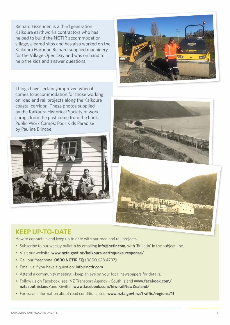
Things have certainly improved when it comes to accommodation for those working on road and rail projects along the Kaikoura coastal corridor. These photos supplied by the Kaikoura Historical Society of work camps from the past come from the book, Public Work Camps: Poor Kids Paradise by Pauline Blincoe.
KEEP UP-TO-DATEHow to contact us and keep up to date with our road and rail projects:
• Subscribe to our weekly bulletin by emailing [email protected], with ‘Bulletin’ in the subject line.
• Visit our website: www.nzta.govt.nz/kaikoura-earthquake-response/
• Call our freephone: 0800 NCTIR EQ (0800 628 4737)
• Email us if you have a question: [email protected]
• Attend a community meeting - keep an eye on your local newspapers for details.
• Follow us on Facebook, see: NZ Transport Agency – South Island www.facebook.com/nztasouthisland/and KiwiRail www.facebook.com/kiwirailNewZealand/
• For travel information about road conditions, see: www.nzta.govt.nz/traffic/regions/11
Richard Fissenden is a third generation Kaikoura earthworks contractors who has helped to build the NCTIR accommodation village, cleared slips and has also worked on the Kaikoura Harbour. Richard supplied machinery for the Village Open Day and was on hand to help the kids and answer questions.

KAIKOURA EARTHQUAKE UPDATE 12
ALTERNATE ROUTE NEWS
RENWICK WIDENING IMPROVEMENT PROVIDING A SAFER STRETCH OF ROADCurrent work at the Blenheim end of the alternate Picton to Christchurch route is providing a much needed piece of widening to improve safety and allow trucks to pass without tracking outside the current seal width.
This first stage on a 1km stretch from SH6 to Angelsea Street in Renwick includes installing a retaining wall and guardrail on the south side and a sealed shoulder on the north.
Once completed, the road width will provide two 3.5m lanes, along with a sealed shoulder. The extra lane width and guardrail will improve safety and reduce the amount and cost of maintaining the current pavement and metal shoulder.
Because of the limited work space and to keep road users and the crew safe, eastbound traffic is being detoured down Angelsea Street through Renwick during the day. Two-way traffic is restored during the evening.
This part of the project is currently scheduled to be completed early October.
The closure of State Highway 1 (SH1) and the Main North Rail Line between Picton and Christchurch following the November 2016 Kaikoura earthquake means traffic now needs to use an alternate route via the alpine Lewis Pass. This route is, in parts, winding, narrow and challenging and has seen a four-fold increase in traffic which it wasn’t designed for. A $60m Government investment has been made to make this route safer and more resilient.

KAIKOURA EARTHQUAKE UPDATE 13
POTHOLES – THE BANE OF EVERYONE’S LIVESAdd constant heavy traffic and wet weather to even the smallest weak spot on a road surface, and within hours you have the making of a very large and sometimes dangerous pothole.
With any patch of wet weather, potholes can quickly multiply. As each passing vehicle forces water into small holes, they gradually get gouged out, progressively becoming larger and deeper.
Without a doubt, potholes are not only the downside of winter, they’re the bane of the road user and the hard working 24/7 crew keeping the alternate Picton to Christchurch route safe and serviceable.
Since the closure of State Highway 1, this alternate route has been supporting far more traffic – both in volume and weight – than it was designed for. A $60m government funding package is enabling the NZ Transport Agency to complete a much needed programme of safety improvements including road widening, pull over areas, slow bays, guard rails and bridge enhancements.
While part of the improvement package is to reseal and rebuild 90km of the road surface along this route this summer, much of that work can’t be done until it is warmer and dyer. Through the winter months, it’s about managing and maintaining the route for road users, which is where the pothole teams come in.
Hundreds of potholes are now being dealt with along the route each week. This constant focus on repairs is good news for road users, but multiple crews also means multiple small delays which can impact on overall journey times.
With the warmer and drier weather expected around September, pothole numbers will start to slow down and the crew can get back to working on the improvement programme, including the much needed resurfacing work.
Until then, the small hi-vis army of pothole crews will continue to be a feature of your drive. Please take extra care around the crews and all work sites. If you come across a pothole and wish to report it, please contact 0800 HIGHWAYS (0800 44 44 49).
HOME-COOKED MEAL FUNDRAISERS A RECIPE FOR SUCCESS WITH ROAD CREWS
In the small community of Murchison, a number of locals are pouring over recipe books working out the next menu for the hungry road crew based in their town.
Since the Kaikoura earthquake, the Murchison-based Fulton Hogan crew and subcontractors, who are maintaining and improving the Tasman section of the alternate Picton to Christchurch route, has increased from less than 10 to more than 100.

KAIKOURA EARTHQUAKE UPDATE 14
That massive ramp up in community presence means a lot of beds to provide and hungry working mouths to feed. Given their large presence, Fulton Hogan approached the community to see what they could do together to be a ‘great neighbour’. The crew have been given a warm welcome with their day to day needs well attended to, but there’s nothing quite like a real family-style meal to make you feel at home. From that thought, a number of community groups have stepped forward with local produce and family recipes to organise fundraising dinners.
Every few weeks a host group gathers to peel and chop mountains of vegetables, prepare local meats (sometimes hunted locally), and other delicacies for sometimes five-course meals at the recreation centre. The crew describe the night as a “beautiful home cooked meal consisting of all the treats and trimmings you’d get at a special family occasion’.
To date, the local rugby club, netball club and school have all acted as ‘home-cooked meal hosts’ to help them with much needed fundraising for facilities and tournament travel.
One Murchison local in the middle of it all is ‘Hammer’. As well as running a small workshop near the Fulton Hogan road crew yard, Hammer provides caretaking at the school, the recreation centre and supports the local rugby club. Along with other members of the community he’s been enthusiastic about connecting people and ideas.
He says fundraising in a small community can be hard. Which is why after seeing this idea work well for local school and church groups in St Arnaud, Hammer saw it as a ‘win-win’ to connect enthusiastic Murchison home cooks with appreciative road crews living away from home.
Principal of Murchison Area School, Andy Ashworth, says they were facing a tough task to raise enough funds to get his team of seven talented students (pictured below) and three teachers all the way up north to the five-day National Area Schools Sports Tournament in Whangarei this month.
They’d worked really hard on local fundraising for many weeks, making slow but steady progress. But it was the one big day of preparation and cooking for a very appreciative road work crew that saw them achieve well over a third of the funds they needed. ‘It was hard work, but we had such a wonderful time. It was brilliant’. And after raising enough to get to the tournament, the icing on this cake was four of their students selected for South Island teams, with one student making it into two national teams.
A big thank you to all the local communities for providing a warm welcome and home away from home environment for our road crews - your support is helping us get the job done.
GET REAL-TIME TRAVEL INFORMATION FOR OUR ROUTE On the NZ Transport Agency’s website: www.nzta.govt.nz/traffic
By phoning 0800 4 HIGHWAYS (0800 44 44 49)
On the Transport Agency’s social media: www.nzta.govt.nz/contact-us/connect-with-us/