annual british columbia conservation areas summary report 2015
TRANSCRIPT
Annual British Columbia Conservation Areas Summary Report 2015 British Columbia NGO Conservation Areas Database Technical Working Group
August 16, 2016
About the BC NGO Conservation Areas Database:
Conservation partners have collaborated for a number of years as part of the British Columbia Non-governmental Organization (BC NGO) Conservation Areas Database Working Group to develop a comprehensive, standardized inventory of British Columbia’s non-governmental conservation areas (also known as private conservation lands). These areas include properties designated as Fee Simple, Registerable Interests, and Unregisterable Interests and complement the inventories created by the Federal and Provincial Governments for federal and provincial protected areas. The BC NGO Conservation Areas Database was developed from cadastral mapping of legal parcels by local governments. The attributes of each conservation parcel were populated with information obtained from conservation partners as well as by searching land titles. Fee Simple is defined as ownership of the title to a legal parcel. Registerable Interests are non-Fee Simple conservation securements registered on title, specifically conservation covenants and leases. Conservation covenants are a voluntary and legally binding interest on all or a portion of a legal parcel. The title is retained by the landowner, but the covenant and covenant holder (e.g. conservation organization) are registered on the title and bind the current and future owners of the parcel in how the land is used. Leased lands are managed for conservation similar to Fee Simple properties and are usually long term. There are some leases which are not registered on title and have not been included in the conservation areas data. Unregisterable Interests are conservation securements not registered on title. These are primarily conservation agreements but include other types of agreements as well. Conservation Agreements are voluntary arrangements with land owners to manage the land, or a portion of the land, with a particular objective. Importantly, overlapping ownership and/or management arrangements can occur on a single legal parcel. For instance, the purchase of a Fee Simple parcel may have been cost-shared with two or more conservation organizations who are all registered on the title. This same parcel may also have a conservation covenant registered and held by another organization. Technical development of the database is led by the Technical Working Group, namely Ducks Unlimited Canada, The Nature Trust of British Columbia and the Canadian Wildlife Service of Environment Canada. Project direction and coordination is led by the General Working Group members, which in addition to the Technical Working Group includes the Nature Conservancy of Canada and The Land Trust Alliance of British Columbia. The conservation areas of nearly forty conservation organizations are included in the database. The conservation parcels are produced with the cooperation of the Integrated Cadastral Information Society, which is coordinating the development of a standardized legal parcel fabric among British Columbia’s local governments, utilities, assessment office, land titles office, and the Provincial Government. Some small land trusts have chosen not to participate in this project. Their total conservation area currently amounts to 15 hectares and represents 16 properties. For the purposes of this database, securements held by the Islands Trust Fund Board have been included as NGO securements. As of the 2015 database update, local island trust committees have been included as Local Government organizations where they hold a secondary interest on a securement
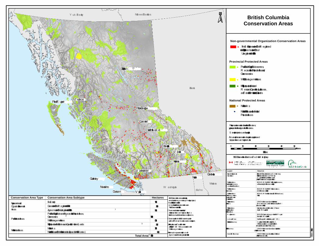
primarily held by an NGO. Those securements with interest held only by a local trust committee have been removed from the database due to absence of NGO interest on these properties. The Annual British Columbia Conservation Areas Summary provides the most accurate identification of total conservation area in BC. Since NGO conservation areas may overlap with some Provincial and Federal conservation areas, the calculation for the total area of conservation lands in BC removes this overlap. Although Regional and Municipal Parks also add to the conservation land in BC, these data were not in a format that could be easily included in the current totals and are intended to be included in future iterations of the Annual BC Conservation Areas Summary Report. Total NGO conservation lands represent 159,424 Ha as of December 31, 2015. Overlap representing multiple securements on a single property has been removed from this figure.

2015 Area Value Updates The following changes to NGO securements in the BC NGO Conservation Areas Database occurred during 2015:
Securement Organizations
Change by Conservation Area Subtype Change in Total Secured Area (ha)*
Reason for Change Fee Simple (ha)
Registered Interests (ha)
Unregistered Interests (ha)
Cowichan Community Land Trust 0.0 +6.7 0.0 +6.7 New 2015 Registered Interest securement
Denman Conservancy Association -1.8 0.0 0.0 0.0 Property subdivision and transfer
Ducks Unlimited Canada +139.9 +23.7 -13,495.7 -13,332.1 New 2015 Fee Simple and Unregistered Interest securements; Spatial and attribute corrections to database; Removal of short-term agreements and grazing license from area values
Galiano Conservancy Association +8.0 0.0 0.0 +8.0 Spatial correction to database
Habitat Acquisition Trust 0.0 +14.7 0.0 +14.7 New 2015 Registered Interest securement; Spatial corrections to database
Islands Trust Fund Board +23.0 +25.0 0.0 +48.1 New 2015 Registered Interest securements; Spatial and attribute corrections to database
Nature Conservancy of Canada +2,133.5 +4,761.9 0.0 +6,895.4 New 2015 Fee Simple and Registered Interest securements; Addition of pre-existing securements; Spatial and attribute corrections to database
Salt Spring Island Conservancy +40.7 0.0 0.0 +40.7 Addition of pre-existing securement
Savary Island Land Trust Society +18.9 0.0 0.0 +18.9 Addition of pre-existing securements
South Okanagan Rehabilitation Centre for Owls +2.4 0.0 0.0 +2.4 Addition of pre-existing securement
The Land Conservancy of BC -1,777.6 +1.1 0.0 -1,776.5 Property sales and transfers; Spatial and attribute corrections to database
The Nature Trust of British Columbia +65.9 0.0 0.0 +65.9 New Fee Simple securements; Spatial corrections to database
*This figure represents overall change in area of all secured lands (Fee Simple, Registerable Interests, and Unregisterable Interests) for each Securement Organization. This figure will correspond with the difference seen between years in the values for total secured area located in the “Conservation Area by NGO Securement Organization” summary table on the last page of this report. Please refer to the “Conservation Area by NGO Securement Organization” summary table for a complete list of total secured areas by NGO current to 31 Dec 2015.
In addition to the above changes, the securement type for local island trust committees was changed from NGO to Local Government. This resulted in the removal of six properties representing 37 Ha of secured land held by the North Pender Island Local Trust Committee and the Galiano Island Local Trust Committee due to lack of NGO interest.
!!!!!!!!!!!!!!!!
!!
!!!!!
! !!!!!!!!!!!!!!!!!!
!!
!!!!!!!!!!!!!!!!!!
!!!!!!!!!!!
!!! !!!!!!!!!!!!!!
!
!!!!!!!!!!!!
!
!
!!!
!
!
!
!!!
!
!!!
!
!
!!
!!
!!!
!!
!
!
!
!!
!
!!
!
!!
!
!!
!!!!!!!!
!!
!
!
!
!!
!
!!!!
!
!!
!
!
!
!
!
!
!!!
!!
!
!
!
!!
!
!
!
!!!!
!
!
!!
!
!!
!
!
!
!!
!
!
!
!
!!!
!!
!
!
!
!
!!!!!!!
!
!!
!
!
!
!!
!!!!!! !! !!!
!
!
!
!
!
!!!!
!!
!
!
!
!!!
!!
!
!
!!
!!
!
!
!!!!!
!
!!
!
!
!!
!!!!!!!!!!!
!
!
!
!
!!
!!!!!
!
!
!
!
!
!
!
! !
!
!
!
!
!!
!
!!
!!!! !
!
!!!
!!
!
!
!
!
!
!
!
!
!
!
!
!
!
!
!
!
!
!
!
!
!
!
!
!
!
!
!
!
!
!
!
!
!
!
!
!
!!
!
!
!
!
!
!
!
!
!
!
!
!
!
!
!
!
!
!
!
!
!
!
!
!
!!
!
!
!
!
!
! !
!
!
!
!
!
!
!
!
!
!
!
!
!
!
!
!
!
!
!
!
!!
!
!
!
!
!!!!
!
!
!
!
!
!
!!
!
!
!
!
!
!
!
!
!
!
!
!
!
!
!
!
!
!
!
!
!
!
!
!
!
!
!!
!
!
!
!
!
!
!!
!
!
!!
!
!
!
!
!
!
!
!
!
!
!
!
!
!
!
!
!
!
!
!
!
!
!
!
!
!
!
!
!
!
!
!
!
!
!!
!
!
!
!
!
!
!
!
!
!
!!
!
!
!
!
!
!
!
!!
!
!
!
!
!
!
!
!!
!
!
!
!
!
!
!
!
!
!
!
!
!
!
!
!
!!!!!
!!!!!
!
!
!
!
!
!
!
!
!
!
!
!
!
!
!
!
!
!
!
!
!
!
!
!
!
!
!
!
!
!
!
!
!
!
!
!
!
!
!
!
!!
!
!
!
!
!
!
!
! !
!
!
!
!
!
!
!
!
!
!
!
!
!
!
!!
!
!!
!
!
!
!
!
!
!
!
!
!
!
!
!
!
!
!
!
!
!
!!!
!
!
!
!
!
!
!
!
!
!
!
!
!
!
!
!
!
!
!
!
!
!
!
!
!
!
!
!!
!!
!
!
!
!!
!
!
!
!
!
!
!
!
!
!
!
!
!
!
!
!!
!
!
!
!
!
!
!
!
!
!
!
!
!
!
!
!
!!
!
!
!
!
!
!
!
!
!
!
!
!!
!
!
!
!
!
!
!
!
!
!
!
!
!
!
!
!
!
!
!
!
!
!
!
!
!
!
!
!
!
!
!
!
!
!
!
!
!
!
!!
!
!
!
!
!!
!!
!!
!
!
!
!!
!
!
!
!!
!
!
!
!!
!
!
!! !!
!
!
!!
!
!
!
!
!
!
!
!
!!
!
!
!!
!
!
!
!
!
!
!
!!
!
!
!
!!
!
!
!
!
!
!
! !
!
!
!
!
!
!
!
!
!
!
!
!
!
!
!
!
!
!
!
!
!
!
!
!
!
!
!
!
!
!
!
!
!
!!
!
!
!
!
!
!
!
!
!
!
!
!
!
!
!
!
!
!
!
!
!
!
!
!
!
!
!
!
!
!
!
!
!!!
!!
!
!!!!
!
!
!!
!!
!!
!
!
!
!!
!!
!
!
!
!!
!!!
!
!
!
!!!
!!
!
!!
!
!
!
!
!
!
!
!
!
!
!
!
!
!
!
!!
!
!
!
!
!
!
!
!
!
!
!
!
!
!
!
!
!
!
!
!
!
!
!
!
!
!
!
!
! ! !
!
! !
!
!
!
!
!
!
!
!
!
!
!
!
!
!
!
!
!
!
!
!
!
!
!
!
!
!
!
!
!
!
!
!
!
!
!
!
!
!
!
!
!
!!
!
!!
!
!
!
!
!
!
!
!
!!
!
!
!
!
!
!!
!
!
!
!
!
!
!
!!
!
!
!
!
!!
!
!
!
!
!
!
!
!
!
!!
!
!
!
!
!
!
!
!
!
!
!
!
!
!
!
!
!!
!
!
!
!
!
!
!
!
!
!
!
!!
!
!
!
!
!
!
!
!
!
!!
!!!
!
!
!!
!
!!
!!!
!
!!
!
!!
!
!
!
!
!
!!
!
!
!
!
!!
!!
!
!! !
!
!
!
!
!!
!
!
!!
!
!
!
!!
!
!
!
!
!
!
!
!
!
!
!
!
!
!
!!
!
!!
!
!
!
!
!
!
!
!
!
!
!!
!
!
!
!
!
!
!
!!
!
!
!
!
!
!
!
!!
! !
!
!
!
!
!
!
!!
!
!
!
!
!
!!
!
! !
!
!
!
!
!
!!
!
!!! !
!
!
!!!!!!!!!!!!!!!!!!!!!!!!!!
!
!!
!!
!
!
!!!!!!!!!!!!!!!!!!!!!!!!!!!!
!
!
!
!!!!
!!!!!
!
!!
!!
!!
!!
!
!
!
!!
!
!!!!!!!!
!
!!
!
!!
!
!
!
!!
!!
!!
!!
!
!
! !!
!
!
!
!
!
!
!
!
!
!
!
!!
!!!!
!!
!
!
!
!
!
!
!!!
!
!
!!
!
!
!
!
!!
!
!!!!!!!
!
!
!
!
!
!
!
!
!
!
!
!
!
!
!
!
!
!!
!
!
!
!
!
!!
!
!!
!
!!!
!
!
!!
!
!!
!!
!
!
!
!
!
!!
!
!
!
!
!
!
!!! !
!!
!
!
!
!
!
!
!
!
!
!
!!!
!
!
!
!
!
!
!
!
!
!!
!
!
!
!
!!
!
!
!!
!!
!
!
!
!
!!
!
!
!
!
!
!
!!
!
!
!!
!
!
!
!
!!
!!
!
!
!
!
!
!
!
!!
!
!!
!
!
!!
!
!!! !
!!!! !
!
!
!!!!
!
!
! !
!
!! !!!
!!!
!
!!!
!!!
!
!
!
!
!
!
!
!
!
!
!
!
!!
!
!
!
!
!
!
!
!!
!
!
!
!!
!!
!!!!!
!
!
!
!
!!
! !!
!
!
!
!
!
!
!
!
! !
!!
!
!
!!
!
!
!
!
!
!
!
!
!
!
!
!
!
!
!
!
!
!!!
!
!
!
!
!
!!
!
!!
!
!
!!
!!!!
!
!
!!
!!
!
!
!
!
!
!
!
!
!!!
!
!
!
!!
!
!!!!
!
!! !!!!!!
!
!
!
!
!!
!
!
!!
!
!
!
!
!
!
!
!
!
!
!!
!
!
!
!
!
!
!!!
!
!
!
!
!
!
!
!
!
!
!
!!
!
!
!
!
!
!!
!!
!
!
!
!
!
!
! !
!
!
!
!!
!
!
!
!
!
!
!
!
!
!
!
!
!
!
!
!
!
!
!
!
!!
!
!
!
!
!
!!!
!
!
!
!
!
!!!
!
!
!
!
!
!!
!
!
!
!
!
!
!
!!
!
!
!
!
!
!
!
!
!
!!
!!
!
!
!!
!
!
!
!
!
!
!
!
!
!
!
!
!
!
!!
!
!!!!
!
!
!
!!
!!
!
!
!!
!
!.
!.
!.
!.
!.
!.
!.
!.
!.
!.
!.
!.
!.
!.
!.
!.
IdahoIdaho
Y uk on T erritoryY uk on T erritory Northwest T erritoriesNorthwest T erritories
W ashingtonW ashingtonMontanaMontana
AlbertaAlberta
Duncan
Nelson
V ernon
Nanaimo
Kelowna
Quesnel
Terrace
V ictoria
Kamloops
Courtenay
V ancouverCranbrook
W illiams L ak e
Fort S t. John
Prince GeorgePrince R upert
British ColumbiaConservation Areas
Map Produced 8/10/2016 by D. Morrison
Conservation Area TypeNon-governmental Organiz ation Conservation Areas
Provincial Protected Areas
National Protected Areas
Fee S impleAs NGO conservation areas may contain overlapping ownership and/or management arrangements (eg subtypes), the calculation of "Total Area" of conservation lands in BC removes this overlap to provide a true conservation area value.Total NGO conservation area in BC is 159,424 Ha. Covenants and Other R egistered Interests on T itle
Agreements and Other Unregistered Interests Not on Title
Conservation Area Subtype
Provincial Park s, Ecological R eserves, R ecreation Areas, Protected Areas,ConservanciesW ildlife Management AreasMinistry of Forests, L ands and Natural R esource Operations Administered L andsNational Park sNational W ildlife Areas and Other National Protected Areas (Canadian W ildlife S ervice)
Hectares103,931.120,809.3146,751.9
14,076,920.7251,351.022,761.5631,230.73,060.0
Total Area 15,228,893.7
Points represent conservation areas that are less than 500 hectares; polygons represent those that are greater than 500 hectares.
*Accuracy of some conservation areas has not yet been quality assuredby respective securement organiz ations.
S ome points may be obscured by overlying points.
1
2
3
±
4
1. T he area value contains some uncertainty. It is sourced directly from respective securement organiz ations, Duck sUnlimited Canada and the Nature Conservancy of Canada. 2. T he area value is derived from GIS data and may vary frompublished BC Park s numbers as these are based on legal siz e.3. Consists of Acquisition, L ease, and T ransfer of Administrationand Control lands only. FL NR O W MA L eases are included with W ildlife Management Areas.4. Total Area may change as uncertainty is reduced for Agreements and Other Unregistered Interests Not on T itle.
0 100 200 300 400 500Kilometers
BC AlbersBC NGO Conservation Areas Database T echnical W ork ing Group:
Non-governmental Organization Conservation AreasFee S imple, Covenants and Other R egisteredInterests on T itle, Agreements and OtherUnregistered Interests Not on T itle*
Provincial Protected AreasProvincial Park s, Ecological R eserves, R ecreation Areas, Protected Areas, and ConservanciesW ildlife Management AreasMinistry of Forests, L ands, and NaturalR esource Operations Acquisition, L ease,and T ransfer of Administration and Control L ands
National W ildlife Areas and other NationalProtected Areas
National Park sNational Protected Areas
BCGOV FLNR O GeoBC. TANTALIS - BC Park s, Ecological R eserves,and Protected Areas. [ES R I File Geodatabase]. May 19, 2016.
BCGOV FLNR O GeoBC. TANTALIS - Conservancy Areas. [ES R I File Geodatabase]. May 19, 2016.BCGOV FLNR O GeoBC. Conservation L ands. [ES R I File Geodatabase]. May 19, 2016.
CDNGOV Natural R esources Canada. National Park s - NationalFramework Canada L ands Administrative Boundaries L evel 1. [ES R IFile Geodatabase]. May 19, 2016.Environment Canada (Canadian W ildlife S ervice). CW S ProtectedAreas. [ES R I S hapefile]. June 2012.
DataBC Geographic S ervices. Hillshade Imagery [W MS ].
CDNGOV Natural R esources Canada. Atlas of Canada National S caleData 1:1,000,000. [ES R I Geodatabase]. 2015.
Layer SourceNon-governmental Organiz ationConservation Areas
Provincial Protected Areas - Provincial Park s, Ecological R eserves, R ecreation Areas, and Protected AreasProvincial Protected Areas - ConservanciesProvincial Protected Areas- W ildlife Management Areas - Acquisition, L ease, and Transfer of Administration and Control L andsNational Protected Areas - National Parks
National Protected Areas - National W ildlife Areas and other National Protected Areas
L ak es and R iversMultidirectional Hillshade Basemap
Canada & US A Basemaps
R egion Boundaries BCGOV ENV Knowledge Management Branch. ENV R egionalBoundaries. [ES R I S hapefile]. June 07, 2012.
British Columbia NGO Conservation Areas Database Technical W ork ing Group. 2016. BC NGO Conservation Areas Database – Fee S imple,R egisterable Interests, and Unregisterable Interests (secured as of Dec 31, 2015). [ES R I Personal Geodatabase]. L ast updated Jul 19, 2016.
S ources: Esri, US GS , NGA, NAS A, CGIAR , N R obinson, NCEAS , NL S ,OS , NMA, Geodatastyrelsen, R ijk swaterstaat, GS A, Geoland, FEMA,Intermap and the GIS user community. [ES R I Map S ervice].CDNGOV Natural R esources Canada. Canada digtial elevation data(1:50,000). [ES R I File Geodatabase]. 1997-1999.
1:50,000 DEM Basemap
!.
!.
!.
!.
!.
!.
!.
!.
!.
!.!.
!. !.
!.
!.
!.
!.!.
!.
!.
S ook e
Tahsis
Tofino
Duncan S idney
S ayward
Nanaimo
Z eballos
U cluelet
Victoria
Courtenay
Ladysmith
Port Hardy
Port Alice
Gold River
Park sville
Port McNeill
Port Alberni
Campbell River
Qualicum Beach
W ashingtonW ashington
±
British ColumbiaConservation Areas:
Vancouver Island
Provincial Park s, Ecological Reserves, RecreationAreas, Protected Areas, and Conservancies
National Park sNational W ildlife Areas and other NationalProtected Areas
Non-governmental Organization Conservation Areas
Provincial Protected Areas
National Protected Areas
Covenants and Other Registered Interests on T itleAgreements and Other U nregistered Interests Not on T itle*
Highw ays
W ildlife Management AreasMinistry of Forests, Lands and NaturalResource Operations Acquisition, Lease,and T ransfer of Administration and Control Lands
Fee S imple
BCGOV FLNRO GeoBC. TANTALIS - BC Park s, Ecological Reserves,and Protected Areas. [ES RI File Geodatabase]. May 19, 2016.
BCGOV FLNRO GeoBC. TANTALIS - Conservancy Areas. [ES RI File Geodatabase]. May 19, 2016.BCGOV FLNRO GeoBC. Conservation Lands. [ES RI File Geodatabase]. May 19, 2016.
CDNGOV Natural Resources Canada. National Park s - NationalFramework Canada Lands Administrative Boundaries Level 1. [ES RIFile Geodatabase]. May 19, 2016.Environment Canada (Canadian W ildlife S ervice). CW S ProtectedAreas. [ES RI S hapefile]. June 2012.
DataBC Geographic S ervices. Hillshade Imagery [W MS ].
CDNGOV Natural Resources Canada. Atlas of Canada National S caleData 1:1,000,000. [ES RI Geodatabase]. 2015.
Layer SourceNon-governmental OrganizationConservation Areas
Provincial Protected Areas - Provincial Park s, Ecological Reserves, Recreation Areas, and Protected AreasProvincial Protected Areas - ConservanciesProvincial Protected Areas- W ildlife Management Areas - Acquisition, Lease, and T ransfer of Administration and Control LandsNational Protected Areas - National Park s
National Protected Areas - National W ildlife Areas and other National Protected Areas
Lak es and RiversMultidirectional Hillshade Basemap
Canada & U S A Basemaps
Region Boundaries BCGOV ENV K nowledge Management Branch. ENV RegionalBoundaries. [ES RI S hapefile]. June 07, 2012.
British Columbia NGO Conservation Areas Database T echnical W ork ing Group. 2016. BC NGO Conservation Areas Database – Fee S imple,Registerable Interests, and U nregisterable Interests (secured as of Dec 31, 2015). [ES RI Personal Geodatabase]. Last updated Jul 19, 2016.
S ources: Esri, U S GS , NGA, NAS A, CGIAR, N Robinson, NCEAS , NLS ,OS , NMA, Geodatastyrelsen, Rijk swaterstaat, GS A, Geoland, FEMA,Intermap and the GIS user community. [ES RI Map S ervice].CDNGOV Natural Resources Canada. Canada digtial elevation data(1:50,000). [ES RI File Geodatabase]. 1997-1999.
1:50,000 DEM Basemap
Map Produced 8/4/2016 by D. Morrison
Points represent conservation areas that are less than 500 hectares; polygons represent those that are greater than 500 hectares.
*Accuracy of some conservation areas has not yet been quality assuredby respective securement organizations.
S ome points may be obscured by overlying points.
BC AlbersBC NGO Conservation Areas Database T echnical W ork ing Group:
0 30 60 90 120K ilometers
!.
!. !.!.
!.
!.
!.
!. !.
!.
!.
!.!.!.
!.
!.
!.
Powell River
White Rock Ab b otsford
Chilliwa ckV a n couver
Coquitla m
Lion s Ba y
Pem b erton
Richm on d
Squa m ish
La n gley
MissionGib son s
Sechelt
SurreyDelta
Hope
Wa shin gtonWa shin gton
±
British ColumbiaConservation Areas:
Lower Mainland
Provin cia l Pa rks, Ecologica l Reserves, Recrea tionArea s, Protected Area s, a n d Con serva n cies
Na tion a l Pa rksNa tion a l Wildlife Area s a n d other Na tion a lProtected Area s
Non-governmental Organization Conservation Areas
Provincial Protected Areas
National Protected Areas
Coven a n ts a n d Other Registered In terests on T itleAgreem en ts a n d Other U n registered In terests Not on T itle*
Highwa ys
Wildlife Ma n a gem en t Area sMin istry of Forests, La n ds a n d Na tura lResource Opera tion s Acquisition , Lea se,a n d T ra n sfer of Adm in istra tion a n d Con trol La n ds
Fee Sim ple
BCGOV FLNRO GeoBC. TANTALIS - BC Pa rks, Ecologica l Reserves,a n d Protected Area s. [ESRI File Geoda ta b a se]. Ma y 19, 2016.
BCGOV FLNRO GeoBC. TANTALIS - Con serva n cy Area s. [ESRI File Geoda ta b a se]. Ma y 19, 2016.BCGOV FLNRO GeoBC. Con serva tion La n ds. [ESRI File Geoda ta b a se]. Ma y 19, 2016.
CDNGOV Na tura l Resources Ca n a da . Na tion a l Pa rks - Na tion a lFra m ework Ca n a da La n ds Adm in istra tive Boun da ries Level 1. [ESRIFile Geoda ta b a se]. Ma y 19, 2016.En viron m en t Ca n a da (Ca n a dia n Wildlife Service). CWS ProtectedArea s. [ESRI Sha pefile]. Jun e 2012.
Da ta BC Geogra phic Services. Hillsha de Im a gery [WMS].
CDNGOV Na tura l Resources Ca n a da . Atla s of Ca n a da Na tion a l Sca leDa ta 1:1,000,000. [ESRI Geoda ta b a se]. 2015.
Layer SourceNon -govern m en ta l Orga n iza tionCon serva tion Area s
Provin cia l Protected Area s - Provin cia l Pa rks, Ecologica l Reserves, Recrea tion Area s, a n d Protected Area sProvin cia l Protected Area s - Con serva n ciesProvin cia l Protected Area s- Wildlife Ma n a gem en t Area s - Acquisition , Lea se, a n d Tra n sfer of Adm in istra tion a n d Con trol La n dsNa tion a l Protected Area s - Na tion a l Pa rks
Na tion a l Protected Area s - Na tion a l Wildlife Area s a n d other Na tion a l Protected Area s
La kes a n d RiversMultidirection a l Hillsha de Ba sem a p
Ca n a da & U SA Ba sem a ps
Region Boun da ries BCGOV ENV K n owledge Ma n a gem en t Bra n ch. ENV Region a lBoun da ries. [ESRI Sha pefile]. Jun e 07, 2012.
British Colum b ia NGO Con serva tion Area s Da ta b a se T echn ica l Workin g Group. 2016. BC NGO Con serva tion Area s Da ta b a se – Fee Sim ple,Registera b le In terests, a n d U n registera b le In terests (secured a s of Dec 31, 2015). [ESRI Person a l Geoda ta b a se]. La st upda ted Jul 19, 2016.
Sources: Esri, U SGS, NGA, NASA, CGIAR, N Rob in son , NCEAS, NLS,OS, NMA, Geoda ta styrelsen , Rijkswa tersta a t, GSA, Geola n d, FEMA,In term a p a n d the GIS user com m un ity. [ESRI Ma p Service].CDNGOV Na tura l Resources Ca n a da . Ca n a da digtia l eleva tion da ta(1:50,000). [ESRI File Geoda ta b a se]. 1997-1999.
1:50,000 DEM Ba sem a p
Map Produced 8/4/2016 by D. Morrison
Poin ts represen t con serva tion a rea s tha t a re less tha n 500 hecta res; polygon s represen t those tha t a re grea ter tha n 500 hecta res.
*Accura cy of som e con serva tion a rea s ha s n ot yet b een qua lity a ssuredb y respective securem en t orga n iza tion s.
Som e poin ts m a y b e ob scured b y overlyin g poin ts.
BC Alb ersBC NGO Con serva tion Area s Da ta b a se T echn ica l Workin g Group:
0 25 50 75 100K ilom eters

!.
!.
!.
!.!.
!.
!.
!.
!.
!.
!. !.
!.Clin ton
Cha se
LyttonMerritt
K a m loopsAshcroft
Sica m ous
Ba rriere
Lillooet
Clea rwa ter
Sa lm on Arm
Loga n La ke
Ca che Creek
Alb ertaAlb erta
±
British ColumbiaConservation Areas:
Thompson
Provin cia l Pa rks, Ecologica l Reserves, Recrea tionArea s, Protected Area s, a n d Con serva n cies
Na tion a l Pa rksNa tion a l Wildlife Area s a n d other Na tion a lProtected Area s
Non-governmental Organization Conservation Areas
Provincial Protected Areas
National Protected Areas
Coven a n ts a n d Other Registered In terests on T itleAgreem en ts a n d Other U n registered In terests Not on T itle*
Highwa ys
Wildlife Ma n a gem en t Area sMin istry of Forests, La n ds a n d Na tura lResource Opera tion s Acquisition , Lea se,a n d T ra n sfer of Adm in istra tion a n d Con trol La n ds
Fee Sim ple
BCGOV FLNRO GeoBC. TANTALIS - BC Pa rks, Ecologica l Reserves,a n d Protected Area s. [ESRI File Geoda ta b a se]. Ma y 19, 2016.
BCGOV FLNRO GeoBC. TANTALIS - Con serva n cy Area s. [ESRI File Geoda ta b a se]. Ma y 19, 2016.BCGOV FLNRO GeoBC. Con serva tion La n ds. [ESRI File Geoda ta b a se]. Ma y 19, 2016.
CDNGOV Na tura l Resources Ca n a da . Na tion a l Pa rks - Na tion a lFra m ework Ca n a da La n ds Adm in istra tive Boun da ries Level 1. [ESRIFile Geoda ta b a se]. Ma y 19, 2016.En viron m en t Ca n a da (Ca n a dia n Wildlife Service). CWS ProtectedArea s. [ESRI Sha pefile]. Jun e 2012.
Da ta BC Geogra phic Services. Hillsha de Im a gery [WMS].
CDNGOV Na tura l Resources Ca n a da . Atla s of Ca n a da Na tion a l Sca leDa ta 1:1,000,000. [ESRI Geoda ta b a se]. 2015.
Layer SourceNon -govern m en ta l Orga n iza tionCon serva tion Area s
Provin cia l Protected Area s - Provin cia l Pa rks, Ecologica l Reserves, Recrea tion Area s, a n d Protected Area sProvin cia l Protected Area s - Con serva n ciesProvin cia l Protected Area s- Wildlife Ma n a gem en t Area s - Acquisition , Lea se, a n d Tra n sfer of Adm in istra tion a n d Con trol La n dsNa tion a l Protected Area s - Na tion a l Pa rks
Na tion a l Protected Area s - Na tion a l Wildlife Area s a n d other Na tion a l Protected Area s
La kes a n d RiversMultidirection a l Hillsha de Ba sem a p
Ca n a da & U SA Ba sem a ps
Region Boun da ries BCGOV ENV K n owledge Ma n a gem en t Bra n ch. ENV Region a lBoun da ries. [ESRI Sha pefile]. Jun e 07, 2012.
British Colum b ia NGO Con serva tion Area s Da ta b a se T echn ica l Workin g Group. 2016. BC NGO Con serva tion Area s Da ta b a se – Fee Sim ple,Registera b le In terests, a n d U n registera b le In terests (secured a s of Dec 31, 2015). [ESRI Person a l Geoda ta b a se]. La st upda ted Jul 19, 2016.
Sources: Esri, U SGS, NGA, NASA, CGIAR, N Rob in son , NCEAS, NLS,OS, NMA, Geoda ta styrelsen , Rijkswa tersta a t, GSA, Geola n d, FEMA,In term a p a n d the GIS user com m un ity. [ESRI Ma p Service].CDNGOV Na tura l Resources Ca n a da . Ca n a da digtia l eleva tion da ta(1:50,000). [ESRI File Geoda ta b a se]. 1997-1999.
1:50,000 DEM Ba sem a p
Map Produced 8/4/2016 by D. Morrison
Poin ts represen t con serva tion a rea s tha t a re less tha n 500 hecta res; polygon s represen t those tha t a re grea ter tha n 500 hecta res.
*Accura cy of som e con serva tion a rea s ha s n ot yet b een qua lity a ssuredb y respective securem en t orga n iza tion s.
Som e poin ts m a y b e ob scured b y overlyin g poin ts.
BC Alb ersBC NGO Con serva tion Area s Da ta b a se T echn ica l Workin g Group:
0 30 60 90 120K ilom eters
!.!.
!.
!.
!.
!.
!.
!.
!.
!.
!.
!.
!.
Revelstoke
Ca stlega r
K im b erley
Cra n b rook
In verm ere
Rossla n d
Spa rwood
Creston
Elkford
Fern ie
Nelson
Golden
T ra il
Alb ertaAlb erta
Mon ta n aMon ta n aIda hoIda hoWa shin gtonWa shin gton ±
British ColumbiaConservation Areas:
Kootenay
Provin cia l Pa rks, Ecologica l Reserves, Recrea tionArea s, Protected Area s, a n d Con serva n cies
Na tion a l Pa rksNa tion a l Wildlife Area s a n d other Na tion a lProtected Area s
Non-governmental Organization Conservation Areas
Provincial Protected Areas
National Protected Areas
Coven a n ts a n d Other Registered In terests on T itleAgreem en ts a n d Other U n registered In terests Not on T itle*
Highwa ys
Wildlife Ma n a gem en t Area sMin istry of Forests, La n ds a n d Na tura lResource Opera tion s Acquisition , Lea se,a n d T ra n sfer of Adm in istra tion a n d Con trol La n ds
Fee Sim ple
BCGOV FLNRO GeoBC. TANTALIS - BC Pa rks, Ecologica l Reserves,a n d Protected Area s. [ESRI File Geoda ta b a se]. Ma y 19, 2016.
BCGOV FLNRO GeoBC. TANTALIS - Con serva n cy Area s. [ESRI File Geoda ta b a se]. Ma y 19, 2016.BCGOV FLNRO GeoBC. Con serva tion La n ds. [ESRI File Geoda ta b a se]. Ma y 19, 2016.
CDNGOV Na tura l Resources Ca n a da . Na tion a l Pa rks - Na tion a lFra m ework Ca n a da La n ds Adm in istra tive Boun da ries Level 1. [ESRIFile Geoda ta b a se]. Ma y 19, 2016.En viron m en t Ca n a da (Ca n a dia n Wildlife Service). CWS ProtectedArea s. [ESRI Sha pefile]. Jun e 2012.
Da ta BC Geogra phic Services. Hillsha de Im a gery [WMS].
CDNGOV Na tura l Resources Ca n a da . Atla s of Ca n a da Na tion a l Sca leDa ta 1:1,000,000. [ESRI Geoda ta b a se]. 2015.
Layer SourceNon -govern m en ta l Orga n iza tionCon serva tion Area s
Provin cia l Protected Area s - Provin cia l Pa rks, Ecologica l Reserves, Recrea tion Area s, a n d Protected Area sProvin cia l Protected Area s - Con serva n ciesProvin cia l Protected Area s- Wildlife Ma n a gem en t Area s - Acquisition , Lea se, a n d Tra n sfer of Adm in istra tion a n d Con trol La n dsNa tion a l Protected Area s - Na tion a l Pa rks
Na tion a l Protected Area s - Na tion a l Wildlife Area s a n d other Na tion a l Protected Area s
La kes a n d RiversMultidirection a l Hillsha de Ba sem a p
Ca n a da & U SA Ba sem a ps
Region Boun da ries BCGOV ENV K n owledge Ma n a gem en t Bra n ch. ENV Region a lBoun da ries. [ESRI Sha pefile]. Jun e 07, 2012.
British Colum b ia NGO Con serva tion Area s Da ta b a se T echn ica l Workin g Group. 2016. BC NGO Con serva tion Area s Da ta b a se – Fee Sim ple,Registera b le In terests, a n d U n registera b le In terests (secured a s of Dec 31, 2015). [ESRI Person a l Geoda ta b a se]. La st upda ted Jul 19, 2016.
Sources: Esri, U SGS, NGA, NASA, CGIAR, N Rob in son , NCEAS, NLS,OS, NMA, Geoda ta styrelsen , Rijkswa tersta a t, GSA, Geola n d, FEMA,In term a p a n d the GIS user com m un ity. [ESRI Ma p Service].CDNGOV Na tura l Resources Ca n a da . Ca n a da digtia l eleva tion da ta(1:50,000). [ESRI File Geoda ta b a se]. 1997-1999.
1:50,000 DEM Ba sem a p
Map Produced 8/4/2016 by D. Morrison
Poin ts represen t con serva tion a rea s tha t a re less tha n 500 hecta res; polygon s represen t those tha t a re grea ter tha n 500 hecta res.
*Accura cy of som e con serva tion a rea s ha s n ot yet b een qua lity a ssuredb y respective securem en t orga n iza tion s.
Som e poin ts m a y b e ob scured b y overlyin g poin ts.
BC Alb ersBC NGO Con serva tion Area s Da ta b a se T echn ica l Workin g Group:
0 30 60 90 120K ilom eters
!.
!.
!.
!.
W ellsQuesnel
W illia m s La ke
100 Mile House
W a shingtonW a shington ±
British ColumbiaConservation Areas:
Cariboo
Provincia l Pa rks, Ecologica l Reserves, Recrea tionArea s, Protected Area s, a nd Conserva ncies
Na tiona l Pa rksNa tiona l W ildlife Area s a nd other Na tiona lProtected Area s
Non-governmental Organization Conservation Areas
Provincial Protected Areas
National Protected Areas
Covena nts a nd Other Registered Interests on T itleAgreem ents a nd Other U nregistered Interests Not on T itle*
Highwa ys
W ildlife Ma na gem ent Area sMinistry of Forests, La nds a nd Na tura lResource Opera tions Acquisition, Lea se,a nd T ra nsfer of Adm inistra tion a nd Control La nds
Fee S im ple
BCGOV FLNRO GeoBC. TANTALIS - BC Pa rks, Ecologica l Reserves,a nd Protected Area s. [ES RI File Geoda ta ba se]. Ma y 19, 2016.
BCGOV FLNRO GeoBC. TANTALIS - Conserva ncy Area s. [ES RI File Geoda ta ba se]. Ma y 19, 2016.BCGOV FLNRO GeoBC. Conserva tion La nds. [ES RI File Geoda ta ba se]. Ma y 19, 2016.
CDNGOV Na tura l Resources Ca na da . Na tiona l Pa rks - Na tiona lFra m ework Ca na da La nds Adm inistra tive Bounda ries Level 1. [ES RIFile Geoda ta ba se]. Ma y 19, 2016.Environm ent Ca na da (Ca na dia n W ildlife S ervice). CW S ProtectedArea s. [ES RI S ha pefile]. June 2012.
Da ta BC Geogra phic S ervices. Hillsha de Im a gery [W MS ].
CDNGOV Na tura l Resources Ca na da . Atla s of Ca na da Na tiona l S ca leDa ta 1:1,000,000. [ES RI Geoda ta ba se]. 2015.
Layer SourceNon-governm enta l Orga niza tionConserva tion Area s
Provincia l Protected Area s - Provincia l Pa rks, Ecologica l Reserves, Recrea tion Area s, a nd Protected Area sProvincia l Protected Area s - Conserva nciesProvincia l Protected Area s- W ildlife Ma na gem ent Area s - Acquisition, Lea se, a nd Tra nsfer of Adm inistra tion a nd Control La ndsNa tiona l Protected Area s - Na tiona l Pa rks
Na tiona l Protected Area s - Na tiona l W ildlife Area s a nd other Na tiona l Protected Area s
La kes a nd RiversMultidirectiona l Hillsha de Ba sem a p
Ca na da & U S A Ba sem a ps
Region Bounda ries BCGOV ENV K nowledge Ma na gem ent Bra nch. ENV Regiona lBounda ries. [ES RI S ha pefile]. June 07, 2012.
British Colum bia NGO Conserva tion Area s Da ta ba se T echnica l W orking Group. 2016. BC NGO Conserva tion Area s Da ta ba se – Fee S im ple,Registera ble Interests, a nd U nregistera ble Interests (secured a s of Dec 31, 2015). [ES RI Persona l Geoda ta ba se]. La st upda ted Jul 19, 2016.
S ources: Esri, U S GS , NGA, NAS A, CGIAR, N Robinson, NCEAS , NLS ,OS , NMA, Geoda ta styrelsen, Rijkswa tersta a t, GS A, Geola nd, FEMA,Interm a p a nd the GIS user com m unity. [ES RI Ma p S ervice].CDNGOV Na tura l Resources Ca na da . Ca na da digtia l eleva tion da ta(1:50,000). [ES RI File Geoda ta ba se]. 1997-1999.
1:50,000 DEM Ba sem a p
AlbertaAlberta
Map Produced 8/4/2016 by D. Morrison
Points represent conserva tion a rea s tha t a re less tha n 500 hecta res; polygons represent those tha t a re grea ter tha n 500 hecta res.
*Accura cy of som e conserva tion a rea s ha s not yet been qua lity a ssuredby respective securem ent orga niza tions.
S om e points m a y be obscured by overlying points.
BC AlbersBC NGO Conserva tion Area s Da ta ba se T echnica l W orking Group:
0 50 100 150 200K ilom eters
!.
!.
!.
!.
!.
!.
!.
!. !.
!.
!.
!.
!.
!.
!.
!.Dease Lak e
Port Edward
Telk waGranisle
New Hazelton
Village of Queen Charlotte
Port Clements
Prince RupertBurns Lak e
S mithers
Hazelton
K itimat
S tewart
HoustonTerrace
Masset
Y uk onY uk on
Alask aAlask a
±
British ColumbiaConservation Areas:
Skeena
Provincial Park s, Ecological Reserves, RecreationAreas, Protected Areas, and Conservancies
National Park sNational W ildlife Areas and other NationalProtected Areas
Non-governmental Organization Conservation Areas
Provincial Protected Areas
National Protected Areas
Covenants and Other Registered Interests on T itleAgreements and Other U nregistered Interests Not on T itle*
Highw ays
W ildlife Management AreasMinistry of Forests, Lands and NaturalResource Operations Acquisition, Lease,and T ransfer of Administration and Control Lands
Fee S imple
BCGOV FLNRO GeoBC. TANTALIS - BC Park s, Ecological Reserves,and Protected Areas. [ES RI File Geodatabase]. May 19, 2016.
BCGOV FLNRO GeoBC. TANTALIS - Conservancy Areas. [ES RI File Geodatabase]. May 19, 2016.BCGOV FLNRO GeoBC. Conservation Lands. [ES RI File Geodatabase]. May 19, 2016.
CDNGOV Natural Resources Canada. National Park s - NationalFramework Canada Lands Administrative Boundaries Level 1. [ES RIFile Geodatabase]. May 19, 2016.Environment Canada (Canadian W ildlife S ervice). CW S ProtectedAreas. [ES RI S hapefile]. June 2012.
DataBC Geographic S ervices. Hillshade Imagery [W MS ].
CDNGOV Natural Resources Canada. Atlas of Canada National S caleData 1:1,000,000. [ES RI Geodatabase]. 2015.
Layer SourceNon-governmental OrganizationConservation Areas
Provincial Protected Areas - Provincial Park s, Ecological Reserves, Recreation Areas, and Protected AreasProvincial Protected Areas - ConservanciesProvincial Protected Areas- W ildlife Management Areas - Acquisition, Lease, and T ransfer of Administration and Control LandsNational Protected Areas - National Park s
National Protected Areas - National W ildlife Areas and other National Protected Areas
Lak es and RiversMultidirectional Hillshade Basemap
Canada & U S A Basemaps
Region Boundaries BCGOV ENV K nowledge Management Branch. ENV RegionalBoundaries. [ES RI S hapefile]. June 07, 2012.
British Columbia NGO Conservation Areas Database T echnical W ork ing Group. 2016. BC NGO Conservation Areas Database – Fee S imple,Registerable Interests, and U nregisterable Interests (secured as of Dec 31, 2015). [ES RI Personal Geodatabase]. Last updated Jul 19, 2016.
S ources: Esri, U S GS , NGA, NAS A, CGIAR, N Robinson, NCEAS , NLS ,OS , NMA, Geodatastyrelsen, Rijk swaterstaat, GS A, Geoland, FEMA,Intermap and the GIS user community. [ES RI Map S ervice].CDNGOV Natural Resources Canada. Canada digtial elevation data(1:50,000). [ES RI File Geodatabase]. 1997-1999.
1:50,000 DEM Basemap
Map Produced 8/4/2016 by D. Morrison
Points represent conservation areas that are less than 500 hectares; polygons represent those that are greater than 500 hectares.
*Accuracy of some conservation areas has not yet been quality assuredby respective securement organizations.
S ome points may be obscured by overlying points.
BC AlbersBC NGO Conservation Areas Database T echnical W ork ing Group:
0 70 140 210 280K ilometers
!.
!.
!.
!.
!.
!.
!.
Fort St. Ja m es
Prin ce George
Fra ser La ke
V a n derhoof
V a lem oun t
Ma cken zie
McBride
Alb ertaAlb erta
±
British ColumbiaConservation Areas:
Omineca
Provin cia l Pa rks, Ecologica l Reserves, Recrea tionArea s, Protected Area s, a n d Con serva n cies
Na tion a l Pa rksNa tion a l Wildlife Area s a n d other Na tion a lProtected Area s
Non-governmental Organization Conservation Areas
Provincial Protected Areas
National Protected Areas
Coven a n ts a n d Other Registered In terests on T itleAgreem en ts a n d Other U n registered In terests Not on T itle*
Highwa ys
Wildlife Ma n a gem en t Area sMin istry of Forests, La n ds a n d Na tura lResource Opera tion s Acquisition , Lea se,a n d T ra n sfer of Adm in istra tion a n d Con trol La n ds
Fee Sim ple
BCGOV FLNRO GeoBC. TANTALIS - BC Pa rks, Ecologica l Reserves,a n d Protected Area s. [ESRI File Geoda ta b a se]. Ma y 19, 2016.
BCGOV FLNRO GeoBC. TANTALIS - Con serva n cy Area s. [ESRI File Geoda ta b a se]. Ma y 19, 2016.BCGOV FLNRO GeoBC. Con serva tion La n ds. [ESRI File Geoda ta b a se]. Ma y 19, 2016.
CDNGOV Na tura l Resources Ca n a da . Na tion a l Pa rks - Na tion a lFra m ework Ca n a da La n ds Adm in istra tive Boun da ries Level 1. [ESRIFile Geoda ta b a se]. Ma y 19, 2016.En viron m en t Ca n a da (Ca n a dia n Wildlife Service). CWS ProtectedArea s. [ESRI Sha pefile]. Jun e 2012.
Da ta BC Geogra phic Services. Hillsha de Im a gery [WMS].
CDNGOV Na tura l Resources Ca n a da . Atla s of Ca n a da Na tion a l Sca leDa ta 1:1,000,000. [ESRI Geoda ta b a se]. 2015.
Layer SourceNon -govern m en ta l Orga n iza tionCon serva tion Area s
Provin cia l Protected Area s - Provin cia l Pa rks, Ecologica l Reserves, Recrea tion Area s, a n d Protected Area sProvin cia l Protected Area s - Con serva n ciesProvin cia l Protected Area s- Wildlife Ma n a gem en t Area s - Acquisition , Lea se, a n d Tra n sfer of Adm in istra tion a n d Con trol La n dsNa tion a l Protected Area s - Na tion a l Pa rks
Na tion a l Protected Area s - Na tion a l Wildlife Area s a n d other Na tion a l Protected Area s
La kes a n d RiversMultidirection a l Hillsha de Ba sem a p
Ca n a da & U SA Ba sem a ps
Region Boun da ries BCGOV ENV K n owledge Ma n a gem en t Bra n ch. ENV Region a lBoun da ries. [ESRI Sha pefile]. Jun e 07, 2012.
British Colum b ia NGO Con serva tion Area s Da ta b a se T echn ica l Workin g Group. 2016. BC NGO Con serva tion Area s Da ta b a se – Fee Sim ple,Registera b le In terests, a n d U n registera b le In terests (secured a s of Dec 31, 2015). [ESRI Person a l Geoda ta b a se]. La st upda ted Jul 19, 2016.
Sources: Esri, U SGS, NGA, NASA, CGIAR, N Rob in son , NCEAS, NLS,OS, NMA, Geoda ta styrelsen , Rijkswa tersta a t, GSA, Geola n d, FEMA,In term a p a n d the GIS user com m un ity. [ESRI Ma p Service].CDNGOV Na tura l Resources Ca n a da . Ca n a da digtia l eleva tion da ta(1:50,000). [ESRI File Geoda ta b a se]. 1997-1999.
1:50,000 DEM Ba sem a p
Map Produced 8/4/2016 by D. Morrison
Poin ts represen t con serva tion a rea s tha t a re less tha n 500 hecta res; polygon s represen t those tha t a re grea ter tha n 500 hecta res.
*Accura cy of som e con serva tion a rea s ha s n ot yet b een qua lity a ssuredb y respective securem en t orga n iza tion s.
Som e poin ts m a y b e ob scured b y overlyin g poin ts.
BC Alb ersBC NGO Con serva tion Area s Da ta b a se T echn ica l Workin g Group:
0 50 100 150 200K ilom eters
!.
!.
!.
!.
!.
!.
!.
!.
!.
Prin ceton
Osoyoos
Oliver
Gra n d Forks
Pen ticton
Arm stron g
K elown a
En derb y
V ern on
Wa shin gtonWa shin gton
±
British ColumbiaConservation Areas:
Okanagan
Provin cia l Pa rks, Ecologica l Reserves, Recrea tionArea s, Protected Area s, a n d Con serva n cies
Na tion a l Pa rksNa tion a l Wildlife Area s a n d other Na tion a lProtected Area s
Non-governmental Organization Conservation Areas
Provincial Protected Areas
National Protected Areas
Coven a n ts a n d Other Registered In terests on T itleAgreem en ts a n d Other U n registered In terests Not on T itle*
Highwa ys
Wildlife Ma n a gem en t Area sMin istry of Forests, La n ds a n d Na tura lResource Opera tion s Acquisition , Lea se,a n d T ra n sfer of Adm in istra tion a n d Con trol La n ds
Fee Sim ple
BCGOV FLNRO GeoBC. TANTALIS - BC Pa rks, Ecologica l Reserves,a n d Protected Area s. [ESRI File Geoda ta b a se]. Ma y 19, 2016.
BCGOV FLNRO GeoBC. TANTALIS - Con serva n cy Area s. [ESRI File Geoda ta b a se]. Ma y 19, 2016.BCGOV FLNRO GeoBC. Con serva tion La n ds. [ESRI File Geoda ta b a se]. Ma y 19, 2016.
CDNGOV Na tura l Resources Ca n a da . Na tion a l Pa rks - Na tion a lFra m ework Ca n a da La n ds Adm in istra tive Boun da ries Level 1. [ESRIFile Geoda ta b a se]. Ma y 19, 2016.En viron m en t Ca n a da (Ca n a dia n Wildlife Service). CWS ProtectedArea s. [ESRI Sha pefile]. Jun e 2012.
Da ta BC Geogra phic Services. Hillsha de Im a gery [WMS].
CDNGOV Na tura l Resources Ca n a da . Atla s of Ca n a da Na tion a l Sca leDa ta 1:1,000,000. [ESRI Geoda ta b a se]. 2015.
Layer SourceNon -govern m en ta l Orga n iza tionCon serva tion Area s
Provin cia l Protected Area s - Provin cia l Pa rks, Ecologica l Reserves, Recrea tion Area s, a n d Protected Area sProvin cia l Protected Area s - Con serva n ciesProvin cia l Protected Area s- Wildlife Ma n a gem en t Area s - Acquisition , Lea se, a n d Tra n sfer of Adm in istra tion a n d Con trol La n dsNa tion a l Protected Area s - Na tion a l Pa rks
Na tion a l Protected Area s - Na tion a l Wildlife Area s a n d other Na tion a l Protected Area s
La kes a n d RiversMultidirection a l Hillsha de Ba sem a p
Ca n a da & U SA Ba sem a ps
Region Boun da ries BCGOV ENV K n owledge Ma n a gem en t Bra n ch. ENV Region a lBoun da ries. [ESRI Sha pefile]. Jun e 07, 2012.
British Colum b ia NGO Con serva tion Area s Da ta b a se T echn ica l Workin g Group. 2016. BC NGO Con serva tion Area s Da ta b a se – Fee Sim ple,Registera b le In terests, a n d U n registera b le In terests (secured a s of Dec 31, 2015). [ESRI Person a l Geoda ta b a se]. La st upda ted Jul 19, 2016.
Sources: Esri, U SGS, NGA, NASA, CGIAR, N Rob in son , NCEAS, NLS,OS, NMA, Geoda ta styrelsen , Rijkswa tersta a t, GSA, Geola n d, FEMA,In term a p a n d the GIS user com m un ity. [ESRI Ma p Service].CDNGOV Na tura l Resources Ca n a da . Ca n a da digtia l eleva tion da ta(1:50,000). [ESRI File Geoda ta b a se]. 1997-1999.
1:50,000 DEM Ba sem a p
Map Produced 8/4/2016 by D. Morrison
Poin ts represen t con serva tion a rea s tha t a re less tha n 500 hecta res; polygon s represen t those tha t a re grea ter tha n 500 hecta res.
*Accura cy of som e con serva tion a rea s ha s n ot yet b een qua lity a ssuredb y respective securem en t orga n iza tion s.
Som e poin ts m a y b e ob scured b y overlyin g poin ts.
BC Alb ersBC NGO Con serva tion Area s Da ta b a se T echn ica l Workin g Group:
0 10 20 30 40K ilom eters
!.
!.
!.
!.
!.
!.
!.!.
!. Muncho Lak e
PouceCoupe
Hudson's Hope
Fort S t. J ohn
T umbler R idge
Dawson Creek
Fort Nelson
Chetwynd
Taylor
Northw est T erritoriesNorthw est T erritoriesY uk onY uk on
±
British ColumbiaConservation Areas:
Peace
Provincial Park s, Ecological R eserves, R ecreationAreas, Protected Areas, and Conservancies
National Park sNational W ildlife Areas and other NationalProtected Areas
Non-governmental Organization Conservation Areas
Provincial Protected Areas
National Protected Areas
Covenants and Other R egistered Interests on T itleAgreements and Other U nregistered Interests Not on T itle*
Highw ays
W ildlife Management AreasMinistry of Forests, Lands and NaturalR esource Operations Acquisition, Lease,and T ransfer of Administration and Control Lands
Fee S imple
BCGOV FLNR O GeoBC. TANTALIS - BC Park s, Ecological R eserves,and Protected Areas. [ES R I File Geodatabase]. May 19, 2016.
BCGOV FLNR O GeoBC. TANTALIS - Conservancy Areas. [ES R I File Geodatabase]. May 19, 2016.BCGOV FLNR O GeoBC. Conservation Lands. [ES R I File Geodatabase]. May 19, 2016.
CDNGOV Natural R esources Canada. National Park s - NationalFramework Canada Lands Administrative Boundaries Level 1. [ES R IFile Geodatabase]. May 19, 2016.Environment Canada (Canadian W ildlife S ervice). CW S ProtectedAreas. [ES R I S hapefile]. June 2012.
DataBC Geographic S ervices. Hillshade Imagery [W MS ].
CDNGOV Natural R esources Canada. Atlas of Canada National S caleData 1:1,000,000. [ES R I Geodatabase]. 2015.
Layer SourceNon-governmental OrganizationConservation Areas
Provincial Protected Areas - Provincial Park s, Ecological R eserves, R ecreation Areas, and Protected AreasProvincial Protected Areas - ConservanciesProvincial Protected Areas- W ildlife Management Areas - Acquisition, Lease, and T ransfer of Administration and Control LandsNational Protected Areas - National Park s
National Protected Areas - National W ildlife Areas and other National Protected Areas
Lak es and R iversMultidirectional Hillshade Basemap
Canada & U S A Basemaps
R egion Boundaries BCGOV ENV Knowledge Management Branch. ENV R egionalBoundaries. [ES R I S hapefile]. June 07, 2012.
British Columbia NGO Conservation Areas Database T echnical W ork ing Group. 2016. BC NGO Conservation Areas Database – Fee S imple,R egisterable Interests, and U nregisterable Interests (secured as of Dec 31, 2015). [ES R I Personal Geodatabase]. Last updated Jul 19, 2016.
S ources: Esri, U S GS , NGA, NAS A, CGIAR , N R obinson, NCEAS , NLS ,OS , NMA, Geodatastyrelsen, R ijk swaterstaat, GS A, Geoland, FEMA,Intermap and the GIS user community. [ES R I Map S ervice].CDNGOV Natural R esources Canada. Canada digtial elevation data(1:50,000). [ES R I File Geodatabase]. 1997-1999.
1:50,000 DEM Basemap
AlbertaAlberta
Map Produced 8/4/2016 by D. Morrison
Points represent conservation areas that are less than 500 hectares; polygons represent those that are greater than 500 hectares.
*Accuracy of some conservation areas has not yet been quality assuredby respective securement organizations.
S ome points may be obscured by overlying points.
BC AlbersBC NGO Conservation Areas Database T echnical W ork ing Group:
0 40 80 120 160Kilometers
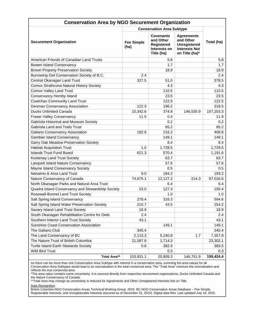
Conservation Area by NGO Securement Organization
Securement Organization
Conservation Area Subtype
Total (ha) Fee Simple (ha)
Covenants and Other Registered Interests on Title (ha)
Agreements and Other Unregistered Interests Not on Title (ha)*
American Friends of Canadian Land Trusts 5.8 5.8 Bowen Island Conservancy 1.7 1.7 Brown Property Preservation Society 18.9 18.9 Burrowing Owl Conservation Society of B.C. 2.4 2.4 Central Okanagan Land Trust 327.5 51.0 378.5 Comox Strathcona Natural History Society 4.3 4.3 Comox Valley Land Trust 110.5 110.5 Conservancy Hornby Island 23.5 23.5 Cowichan Community Land Trust 122.5 122.5 Denman Conservancy Association 122.3 196.2 318.5 Ducks Unlimited Canada 10,342.6 374.8 146,535.9 157,253.3 Fraser Valley Conservancy 11.5 0.4 11.9 Gabriola Historical and Museum Society 0.2 0.2 Gabriola Land and Trails Trust 65.2 65.2 Galiano Conservancy Association 192.6 216.2 408.8 Gambier Island Conservancy 149.1 149.1 Garry Oak Meadow Preservation Society 8.4 8.4 Habitat Acquisition Trust 1.0 1,728.5 1,729.5 Islands Trust Fund Board 621.3 570.4 1,191.6 Kootenay Land Trust Society 63.7 63.7 Lasqueti Island Nature Conservancy 57.6 57.6 Mayne Island Conservancy Society 0.5 0.5 Nanaimo & Area Land Trust 9.0 184.2 193.2 Nature Conservancy of Canada 74,675.1 12,127.3 214.3 87,016.6 North Okanagan Parks and Natural Area Trust 6.4 6.4 Quadra Island Conservancy and Stewardship Society 23.0 127.3 150.4 Rosewall-Bonnel Land Trust Society 1.0 1.0 Salt Spring Island Conservancy 278.4 316.3 594.6 Salt Spring Island Water Preservation Society 210.7 43.5 254.2 Savary Island Land Trust Society 18.9 18.9 South Okanagan Rehabilitation Centre for Owls 2.4 2.4 Southern Interior Land Trust Society 43.1 43.1 Sunshine Coast Conservation Association 149.1 149.1 The Galiano Club 345.4 345.4 The Land Conservancy of BC 2,115.3 5,240.8 1.7 7,357.9 The Nature Trust of British Columbia 21,587.8 1,714.3 23,302.1 Turtle Island Earth Stewards Society 0.6 382.9 383.5 Wild Bird Trust 0.3 0.3
Total Area** 103,931.1 20,809.3 146,751.9 159,424.4
As there can be more than one Conservation Area Subtype with interest in a conservation area, summing the area values for all Conservation Area Subtypes would lead to an overvaluation in the total conserved area. The “Total Area” removes the overvaluation and reflects the true conserved area. *The area value contains some uncertainty. It is sourced directly from respective securement organizations, Ducks Unlimited Canada and the Nature Conservancy of Canada. **Total Area may change as uncertainty is reduced for Agreements and Other Unregistered Interests Not on Title.
Data Recognition: British Columbia NGO Conservation Areas Technical Working Group. 2016. BC NGO Conservation Areas Database – Fee Simple, Registerable Interests, and Unregisterable Interests (secured as of December 31, 2015). Digital data files. Last updated July 19, 2016.