annual report 1999/2000 - welcome - ansiransir.org.au/ar/ansir_ar_1999-2000.pdf · ansir annual...
TRANSCRIPT
ANNUAL REPORT
1999/2000
The Australian National Seismic Imaging Resource (ANSIR) is established andsupported under the Australian Government’s Major National Research Facility Program
ANSIR Annual Report 1999/2000
TABLE OF CONTENTS
ANSIR MANAGEMENT ADVISORY BOARD REPORT i
ANSIR MISSION STATEMENT ii
THE ROLE OF ANSIR 1
ANSIR RESEARCH 2
Case Study One Rabaul Caldera Project 10
Case Study Two Lithospheric structure of the Trans-Antarctic
Mountains, Antarctica 12
Case Study Three BHP Collieries, NSW 14
Case Study Four Central Lachlan Fold Belt, NSW 16
Case Study Five Eastern Goldfields, WA 18
FACILITY PROMOTION 20
COLLABORATION, EDUCATION AND TRAINING OPPORTUNITIES 22
CONTRIBUTION TO AUSTRALIAN INDUSTRIES 23
STAFFING AND ADMINISTRATION 25
GRANTS AND AWARDS 29
PERFORMANCE INDICATORS AND PERFORMANCE MEASURES 30
PUBLICATIONS 1999/2000 33
PERSONNEL ASSOCIATED WITH ANSIR DURING 1999/2000 36
ATTACHMENT A – Asset Listing as at 30 June 2000
ATTACHMENT B – Auditor’s Report 1999/2000

ANSIR Annual Report 1999/2000
i
This has been ANSIR’s first full year ofoperations, following the delivery of the bulk ofour equipment and the formal launch of ANSIRduring the previous year. The research supportedthis year continues to illustrate the broadcapabilities of ANSIR. Some of the results arepresented in this report; others will be released inlater years following the lengthy and oftendifficult data processing and analysis phases thatof necessity follow some kinds of experiments.
ANSIR equipment was deployed in a widevariety of operating conditions, from the aridregions of western Australia to the lush greenfields of southeast Australia. ANSIR portablerecorders were used for the first time inAntarctica, where they operated well in aninternational collaborative experiment involvingthe Research School of Earth Sciences at theAustralian National University and the NewZealand Institute of Geological and NuclearSciences. This year’s experiments were designedto image features as large as the south east cornerof the continent, to depths as great as 400km, andas small as potentially mineralised faults lyingonly a few hundred metres below the surface nearWest Wyalong in New South Wales.
Many of ANSIR’s results were benchmarkedagainst comparable datasets from around theworld at the International Union of Geodesy andGeophysics Conference in Birmingham in July1999, and the Millennial 9th InternationalSymposium on Deep Seismic Profiling of theContinents and their Margins, at Ulvik, Norwayin June 2000. Our images have remarkable claritycompared with those from other countries, andperhaps more importantly the interpretations andgeological meaning interpreted from the imageswere in the vanguard of international effort.
ANSIR continues to provide “national leadership,international visibility and collaboration incommunity service through the use and operationof world class facilities for seismologicalresearch”, our primary objective. The ANSIRDirector and Deputy Director have been active innational and international scientific committees.
ANSIR has also taken a role in the developmentof science policy issues in Australia, throughsubmissions to a number of reviews ofAustralia’s science and technology capabilities.The Director represented ANSIR at the NationalInnovation Summit in Melbourne, and is amember of a Working Group of theCommonwealth Coordinating Committee onScience and Technology that is developingstrategies for providing long term support for theestablishment and operation of Major NationalResearch Facilities.
After three years of the establishment and initialoperations of ANSIR, it is clear that theAustralian university sector does not have thehuman or financial resources to access ANSIR,or other major national research facilities, in sucha way that could lead to a new generation ofEarth science research. This was recognised inour last Annual Report. Our most significantnational leadership role in the last year has beenfor the ANSIR Board to articulate the case for anational program of collaborativemultidisciplinary research and research trainingin the Earth sciences, as a means of addressingthis issue. We have taken the case out to theuniversity sector, and plans are now in place tolead the research and industry communitiestowards establishing such a program in 2 – 3year’s time.
Professor John Lovering OAChairman, Management Advisory BoardSeptember, 2000
REPORT OF THE ANSIRMANAGEMENT ADVISORY BOARD

ii
ANSIR Annual Report 1999/2000
ANSIR MISSION STATEMENT
To place Australia amongst the world leaders in research into the sub-surface structure andcomposition of the Earth.
Our Objectives:
1. Establish and maintain a Major National Research Facility (MNRF) as the basis for excellence inthe field of Seismic Imaging of the Earth by providing national leadership, international visibilityand collaboration in community service through the use and operation of world class facilities forseismological research.
2. Promote the Facility and its role widely with the aim of
• encouraging use of the Facility; and• promoting the MNRF Program.
3. Seek opportunities to enhance the Facility. 4. Manage our Intellectual Property in such a manner as to ensure that the maximum benefit accrues
to Australia, including Australian industry, the Australian environment and the Australianeconomy generally.
The Major National Research Facilities Program:
“The objective of the MNRF program is to facilitate the establishment of major national researchfacilities required for Australia to maintain and enhance its international scientific, industrial andsocial competitiveness over the next decade. The program optimises interaction and collaboration withmajor international research endeavours with the aim of increasing Australia’s internationalcompetitiveness. Access arrangements by Australian researchers to overseas facilities andmultinational consortia are also included in the program. A national facility should engender a sense ofnational purpose, public pride and community understanding of the role of science and technology.”
Commonwealth Department of Industry, Science & Resources, August, 1999

ANSIR Annual Report 1999/2000
1
The Australian National Seismic ImagingResource (ANSIR) is a Major National ResearchFacility. ANSIR seeks to strengthen research andeducation in the Earth sciences in Australia, andto provide a national focus and leadership for theEarth sciences. In ANSIR, AGSO and ANU haveestablished a pool of equipment capable ofimaging the Earth’s interior at a range of scalesusing seismic techniques. ANSIR’s equipment isportable, and can be moved to any part of thecontinent, and indeed overseas for internationalcollaborative experiments. It can record seismicenergy from a range of sources, includingearthquakes, explosions and truck-mountedground vibrators. It can operate in a wide rangeof environments, including the remote hot anddusty conditions of Australian outback, thehumid tropics of the north and the freezingconditions of Antarctica.
Experience with national Earth science researchprograms overseas has shown that seismicimaging can play a leadership, coordinating and
linking role that encourages and facilitatescollaboration between individual scientists,between institutions, and across sectors.
ANSIR is a joint venture of the AustralianGeological Survey Organisation (AGSO) and theResearch School of Earth Sciences at theAustralian National University (ANU). It wasestablished in June 1997 under the AustralianGovernment’s Major National Research Facilities(MNRF) Program. In funding MNRF's in acoordinated and comprehensive manner, thegovernment was seeking to strategically developthe national science and technologyinfrastructure. The purpose was to keep Australiaat the leading edge of key technologicaldevelopments and so enhance its scientific andindustrial competitiveness. The establishment ofMNRF's recognises that major scientific andtechnological advances are increasinglydependent on researchers having access to veryexpensive equipment and facilities beyond theresources of most institutions to finance.
THE ROLE OF ANSIR
Figures 1-4 (Clockwise from top left): ANSIR vibrator trucks in the semi-desert northeast of Broken Hill(Photo: Andrew Owen, AGSO); ANSIR’s broad band Orion portable seismographs deployed in Antarctica(Photo: Stephen Bannister, IGNS, New Zealand); The humid tropical environment to Australia’s northrequires robust electronics and equipment packaging (Photo: Doug Finlayson, AGSO); Dr Frank Graeber,Monash University in the lush green fields of Victoria (Photo: Dr Greg Houseman, Monash University).

2
ANSIR Annual Report 1999/2000
Seismic imaging research has a long time frame.Some experiments take several years to plan andthen process and analyse the results. Figure 5shows the distribution of all projects undertakento date. Although some of these field experimentswere undertaken in previous years, activeresearch on the data from all of these projects andthe publication of results continued through1999/2000.
Table 1 lists projects undertaken prior to1999/2000. Table 2 lists projects undertaken in1999/2000, and Table 3 lists projects for whichANSIR has received firm applications forequipment time in future years. Planning is now
underway for these projects.
ANSIR’s wide range of projects delivers resultsthat have social, environmental and economicbenefits. As our portfolio of projects grows, thereporting of all results becomes impossible in anAnnual Report. The following case historiesserve to illustrate the breadth of the research andthe benefits it brings. The formal publicationslisted later in this report, and in previous AnnualReports, provide a more comprehensivediscussion of the results.
ANSIR
Project Activities
Basinssingle basinoverlapdual overlaphighdeep shelfhard rockvolcanic
CoastlineRabaul, PNG
Antarctica
Project area
Figure 5: ANSIR equipment has been used across Australia, Papua New Guinea and Antarctica. The reddots indicate regions where experiments have been undertaken to date; some experiments cover largeareas of the continent (eg. Figure 6), some are conducted along lines hundreds of kilometres long (eg.Case Study 2) and others cover small areas.
ANSIR RESEARCH
ANSIR Annual Report 1999/2000
3
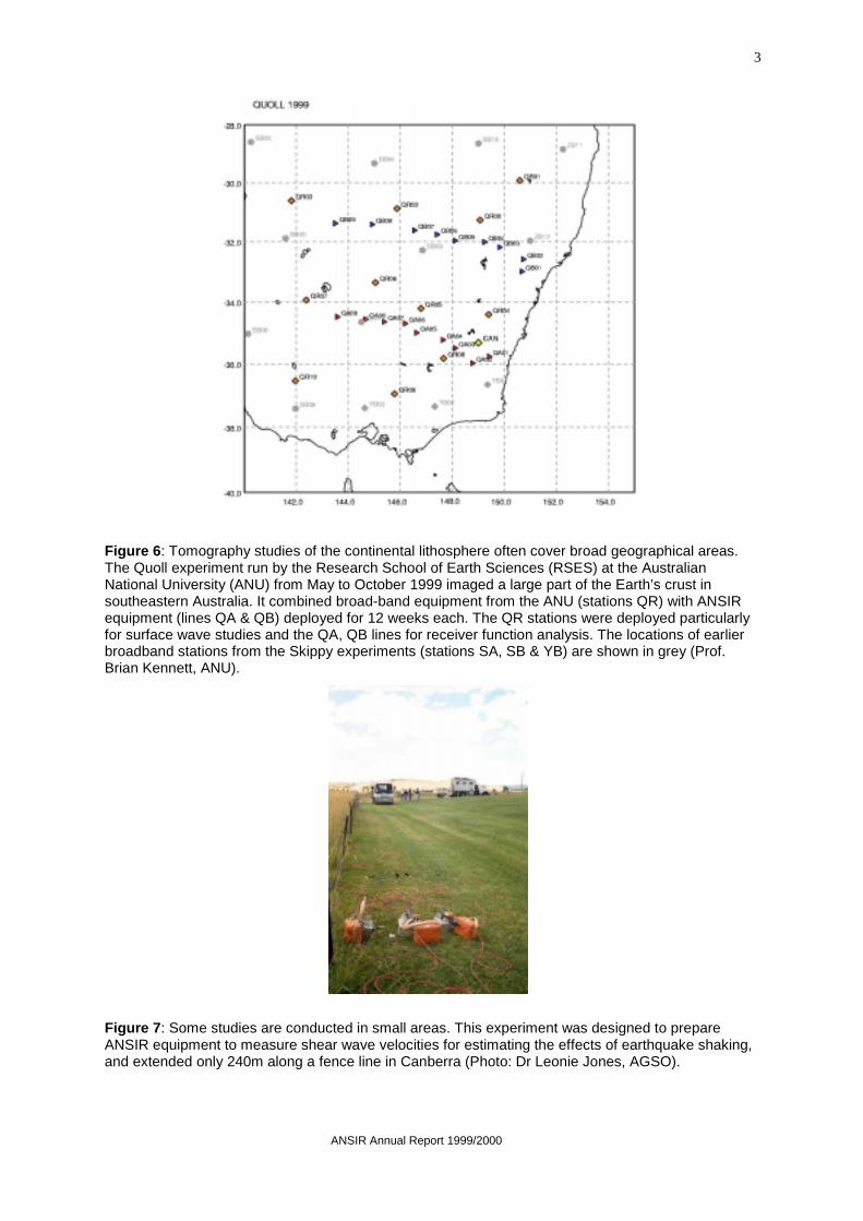
Figure 6: Tomography studies of the continental lithosphere often cover broad geographical areas.The Quoll experiment run by the Research School of Earth Sciences (RSES) at the AustralianNational University (ANU) from May to October 1999 imaged a large part of the Earth’s crust insoutheastern Australia. It combined broad-band equipment from the ANU (stations QR) with ANSIRequipment (lines QA & QB) deployed for 12 weeks each. The QR stations were deployed particularlyfor surface wave studies and the QA, QB lines for receiver function analysis. The locations of earlierbroadband stations from the Skippy experiments (stations SA, SB & YB) are shown in grey (Prof.Brian Kennett, ANU).
Figure 7: Some studies are conducted in small areas. This experiment was designed to prepareANSIR equipment to measure shear wave velocities for estimating the effects of earthquake shaking,and extended only 240m along a fence line in Canberra (Photo: Dr Leonie Jones, AGSO).

4
ANSIR Annual Report 1999/2000
TABLE 1: Projects undertaken prior to 1999/2000 1997/98
PROJECT TITLE PRINCIPAL INVESTIGATOR OBJECTIVE
BROAD BAND INSTRUMENTS
Kimberley Broad Band Trials, WA. Prof. Brian Kennett, ANU. Trial of the Orion recorders and Guralp broad bandseismometers in hot dusty Australian conditions.
SHORT PERIOD INSTRUMENTS
Rabaul Caldera, PNG. Dr Wally Johnson, AGSO; Dr OllieGudmundsson, ANU; Dr HidekiShimamura, Hokkaido University;Prof. Cliff Thurber, University ofWisconsin.
Create a 3D tomographic velocity model of theRabaul Caldera in order allow accurate location ofearthquakes associated with the ascent of magmasbeneath the volcanoes, as input to better emergencymanagement procedures.
Road Rollers, ACT. Prof. Brian Kennett, ANU. Use several short period instruments to measure thevibrations from road rollers working in an urbanisedenvironment; test of the calibration of theinstruments and their ability to continue working inconditions of high ground acceleration.
Quarry Blast Recording, NSW. Dr Karsten Gohl, MacquarieUniversity; Prof. Brian Kennett,ANU.
Trial with Macquarie University of the efficacy of theshort period instruments for recording quarry blastsfor crustal refraction experiments.
REGIONAL SCALE REFLECTION PROFILING
Hamersley Basin, WA. Dr Chris Powell, Tectonics SpecialResearch Centre, Univ. WA,MERIWA, BHP Iron Ore, RobeRiver Mining Co Pty Ltd, AGSO.
Use deep seismic reflection profiles to study multipleepisodes of deformation in the southern HamersleyBasin, and test models for the establishment of ironore deposits by circulating basin brines.
Kalgoorlie, WA. Dr Bruce Goleby, AGCRC/AGSO,Dr Roger Bateman, KalgoorlieConsolidated Gold Mines.
Use regional and high-resolution seismic reflectionprofiles to study the structure of the greenstonesequences that host the Golden Mile deposits atKalgoorlie.
Lachlan Fold Belt, NSW. Dr Russell Korsch,AGCRC/AGSO, Dr Richard Glen,NSW Department of MineralResources.
Record three deep seismic reflection traverses nearParkes, NSW, to study structures in the LachlanTransverse Zone.
OTHER EXPERIMENTS
Broken Hill, NSW. Dr James Leven AGCRC/AGSO. Use seismic refraction profiling to study thecomposition and internal structure of the Broken HillBlock and its southeastern margin.
Lachlan Fold Belt, NSW. Dr Douglas Finlayson,AGCRC/AGSO, NSW Departmentof Mineral Resources.
Use seismic refraction profiling to determine whetherthe Lachlan Transverse Zone has any crustalexpression other than a disruption to structuralpatterns in the surface geology.

ANSIR Annual Report 1999/2000
5
TABLE 1 cont.: 1998/99
PROJECT TITLE PRINCIPAL INVESTIGATOR OBJECTIVE
BROAD BAND INSTRUMENTS
Kimberley Broad Band Trials, WA. Prof. Brian Kennett, ANU. Trial of the Orion recorders and Guralp broadband seismometers in hot dusty Australianconditions (Project continued from previousyear).
99-02T: Crustal and lithosphericstructure of the western Lachlan FoldBelt in Victoria using the receiverfunction method.
Assoc. Prof. Greg Houseman,Monash University.
Obtain direct measurements of Moho depth andintracrustal structure to enhance tomographicinversions of travel time residuals obtained froma previous project using short periodinstruments (Project continuing into 1999/2000).
98-04T: QUOLL99, Investigation ofcrustal and upper mantle structurebeneath SE Australia.
Prof. Brian Kennett, ANU. Investigate the velocity transition in the uppermantle beneath SE Australia at depths from 80to 200 km (Project continuing into 1999/2000).
SHORT PERIOD INSTRUMENTS
99-04T: The measurement of seismicityaround an active mining area.
Greg Poole, BHP Coal; Dr PeterHatherley, CSIRO.
Assess any seismic activity that may be presentin an active underground mining area andcompare the event positions with knowngeological structures (Project continuing into1999/2000).
HIGH RESOLUTION REFLECTION IMAGING
98-01R: High resolution seismic imagingof prospective mineralisation zone nearParkes, NSW.
Dr Karsten Gohl,Macquarie University.
Test the efficacy of high-resolution seismictechniques for imaging circular volcanic zoneand volcanic porphyry intrusions that havesignificant potential for copper goldmineralisation, near Parkes, NSW.
98-09RT: Cootamundra, NSW, palaeo-drainage project.
Dr Ken Lawrie, AGSO. This pilot project aims to use a combination ofaeromagnetic, gravity, airborne EM and seismicdata to delineate the structure of the regolith inthe Cootamundra district as a means ofunderstanding the palaeo-drainage system andits evolution. The study is relevant to emergentdry land salinity problems and Au depositsassociated with the old drainage channels.
REGIONAL SCALE REFLECTION PROFILING
98-10R: Darling Basin, NSW, RegionalStudy: basin architecture anddevelopment.
Mr Barry Willcox, AGSO. Define controls on the architecture of theDarling Basin in the region of the Euriowie BlockNNE of Broken Hill, NE across the BancanniaTrough, Wonominta Block and into a possibleextension of the Darling Basin as indicated by aregional gravity low.

6
ANSIR Annual Report 1999/2000
TABLE 2: Field Projects Undertaken in 1999/00
PROJECT TITLE PRINCIPAL INVESTIGATOR OBJECTIVE
BROAD BAND INSTRUMENTS
98-17T: Lithospheric structure ofTransAntarctic Mountains and Wilkesland, Antarctica.
Dr Fred Davey, IGNS, NZ. Define the lithospheric structure ofTransAntarctic Mountains and Wilkes Basin,Antarctica. Understand the processes involvedin lithospheric rifting. Investigate the paradox oftectonic activity – recent uplift, subsidence andfaulting – but low seismicity of Antarctica.
98-03T: The relation of the Archaeancratons in Western Australia to structurein the mantle.
Prof. Brian Kennett, ANU. Improved understanding of the structurebeneath the Precambrian of Western Australia.Relation of lithospheric thickness and characterto province age. Improved crustal structure fromreceiver function studies.
99-02T: Crustal and lithosphericstructure of the Western Lachlan FoldBelt in Victoria using the receiverfunction method.
Assoc. Prof. Greg Houseman,Monash University.
To deploy 4 broadband triaxial recorders as asmall array in the western Lachlan Fold Belt ofVictoria to record teleseisms for a 4-monthperiod. The data will be interpreted using thereceiver function method to obtain directmeasurements of Moho depth and intra-crustalstructure. These data will be used to enhancethe tomographic inversions of travel-timeresiduals obtained in the earlier LF98 project.
SHORT PERIOD INSTRUMENTS
99-06T: The measurement of seismicityaround an active mining area.
Greg Poole, BHP Coal. Continue to assess any seismic activity thatmay be present in an active underground coalmining area where the longwall method is beingused. Using source location softwaredetermines the position and relative magnitudeof any event. Compare the event position withknown geological structures and/or conduct asurface seismic reflection survey over the area.
REGIONAL SCALE REFLECTION PROFILING
98-08R&T: AGCRC Yilgarn SeismicTransect, WA.
Dr Bruce Goleby,AGCRC/AGSO.
The AGCRC considers the next fundamentalleap in our understanding of the granite-greenstones will come from two objectives: (a)by seismically examining the 3D geometry of awell documented greenstone belt where thesurface geology and deformational history arewell known; and (b) by seismically examining aregion lying outside the Kalgoorlie Terrain totest whether the detachment model proposed bythe AGCRC is applicable to other regions in theYilgarn Block.
98-15R&T: AGCRC Lachlan II SeismicTransect.
Dr Russell Korsch,AGCRC/AGSO
The AGCRC collected seismic reflection andrefraction data from two geological provinceswithin the Lachlan Fold Belt in 1997. Thisproject will extend the length of these surveys togain further information of the structure,geodynamic history and mineral systemsoperational within a further part of the LachlanFold Belt.
ANSIR Annual Report 1999/2000
7
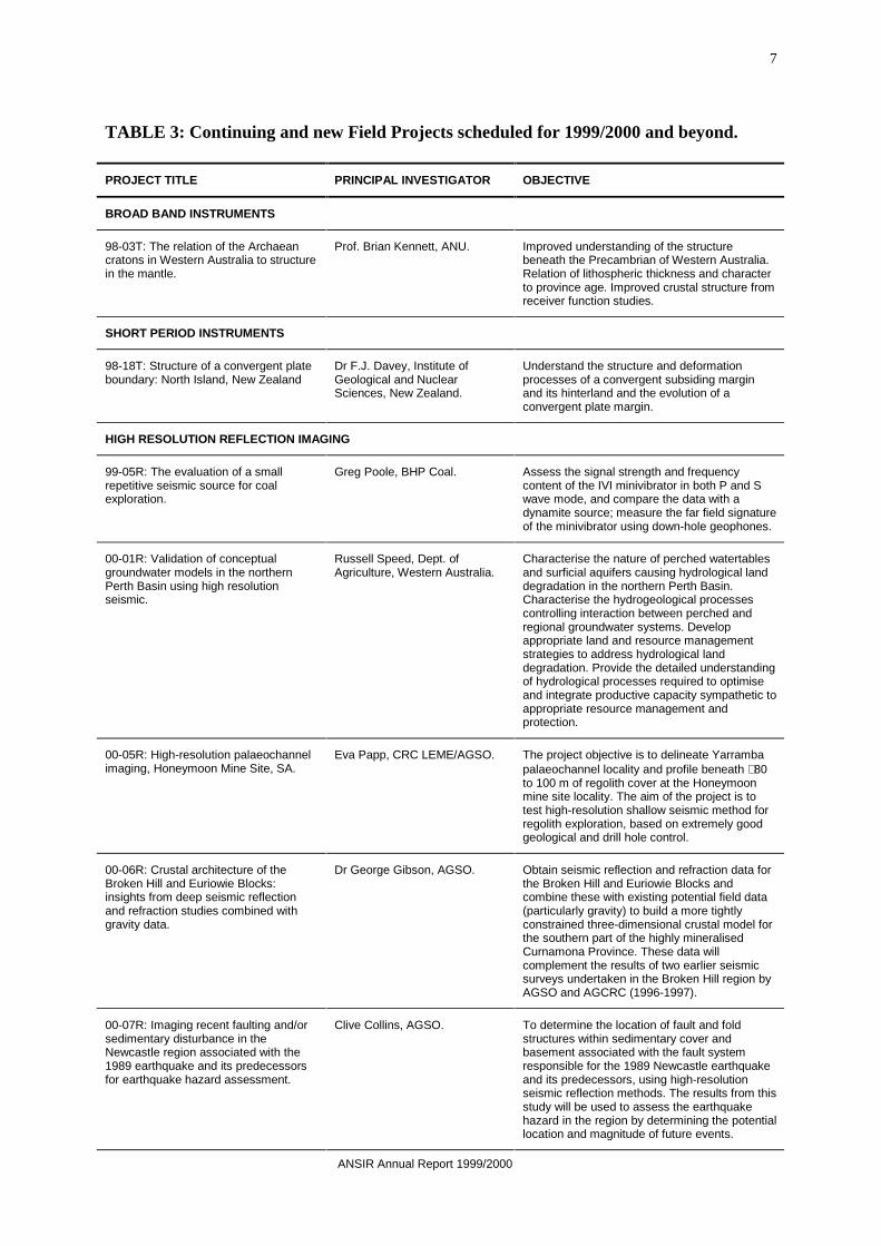
TABLE 3: Continuing and new Field Projects scheduled for 1999/2000 and beyond.
PROJECT TITLE PRINCIPAL INVESTIGATOR OBJECTIVE
BROAD BAND INSTRUMENTS
98-03T: The relation of the Archaeancratons in Western Australia to structurein the mantle.
Prof. Brian Kennett, ANU. Improved understanding of the structurebeneath the Precambrian of Western Australia.Relation of lithospheric thickness and characterto province age. Improved crustal structure fromreceiver function studies.
SHORT PERIOD INSTRUMENTS
98-18T: Structure of a convergent plateboundary: North Island, New Zealand
Dr F.J. Davey, Institute ofGeological and NuclearSciences, New Zealand.
Understand the structure and deformationprocesses of a convergent subsiding marginand its hinterland and the evolution of aconvergent plate margin.
HIGH RESOLUTION REFLECTION IMAGING
99-05R: The evaluation of a smallrepetitive seismic source for coalexploration.
Greg Poole, BHP Coal. Assess the signal strength and frequencycontent of the IVI minivibrator in both P and Swave mode, and compare the data with adynamite source; measure the far field signatureof the minivibrator using down-hole geophones.
00-01R: Validation of conceptualgroundwater models in the northernPerth Basin using high resolutionseismic.
Russell Speed, Dept. ofAgriculture, Western Australia.
Characterise the nature of perched watertablesand surficial aquifers causing hydrological landdegradation in the northern Perth Basin.Characterise the hydrogeological processescontrolling interaction between perched andregional groundwater systems. Developappropriate land and resource managementstrategies to address hydrological landdegradation. Provide the detailed understandingof hydrological processes required to optimiseand integrate productive capacity sympathetic toappropriate resource management andprotection.
00-05R: High-resolution palaeochannelimaging, Honeymoon Mine Site, SA.
Eva Papp, CRC LEME/AGSO. The project objective is to delineate Yarrambapalaeochannel locality and profile beneath ∼80to 100 m of regolith cover at the Honeymoonmine site locality. The aim of the project is totest high-resolution shallow seismic method forregolith exploration, based on extremely goodgeological and drill hole control.
00-06R: Crustal architecture of theBroken Hill and Euriowie Blocks:insights from deep seismic reflectionand refraction studies combined withgravity data.
Dr George Gibson, AGSO. Obtain seismic reflection and refraction data forthe Broken Hill and Euriowie Blocks andcombine these with existing potential field data(particularly gravity) to build a more tightlyconstrained three-dimensional crustal model forthe southern part of the highly mineralisedCurnamona Province. These data willcomplement the results of two earlier seismicsurveys undertaken in the Broken Hill region byAGSO and AGCRC (1996-1997).
00-07R: Imaging recent faulting and/orsedimentary disturbance in theNewcastle region associated with the1989 earthquake and its predecessorsfor earthquake hazard assessment.
Clive Collins, AGSO. To determine the location of fault and foldstructures within sedimentary cover andbasement associated with the fault systemresponsible for the 1989 Newcastle earthquakeand its predecessors, using high-resolutionseismic reflection methods. The results from thisstudy will be used to assess the earthquakehazard in the region by determining the potentiallocation and magnitude of future events.
8
ANSIR Annual Report 1999/2000
TABLE 3 cont.: Continuing and new Field Projects scheduled for 1999/2000 and beyond.
00-08R: Imaging mine workings beneathNewcastle for earthquake hazardassessment.
Clive Collins, AGSO. To test the ability of high-resolution seismicreflection methods to image abandonedunderground mine workings beneath urbanareas so that their impact on the earthquakehazard can be assessed.
00-09R: Acquisition of shear-wavevelocities and basement geometry forearthquake hazard assessment.
Clive Collins, AGSO. To develop improved methods of earthquakehazard assessment in Australian urban areasthrough more robust in-situ measurement of keyphysical properties and geological structures.
REGIONAL SCALE REFLECTION PROFILING
00-02R: Prince Charles MountainsExpedition of Germany-Australia(PCMEGA) expression of interestproposal to undertake a seismicprogram in 2002/03.
Assoc. Prof. Chris Wilson,University of Melbourne.
In 2002/03 it is proposed to mount a combinedAustralian and German expedition (PCMEGA)to investigate geological and geophysicalfeatures in the southern Prince CharlesMountains, Antarctica. High-resolution airbornegeophysical data acquisition will be undertakento define subglacial topography and geologicalterrain boundaries. A high-resolution seismicreflection profiling would be undertaken acrossthe Lambert Glacier and adjacent areas andshould be considered as possibly piggy-backingon the logistic support provided by the mainASAC Geophysical Research Program. It wouldbe focussed on defining the nature of theboundaries across the Lambert Grabenstructure, now occupied by the Lambert Glacier,and the boundaries of the adjacent Terrainboundaries.
00-03R: Seismic imaging of the granite-greenstone terranes, Laverton-Leonoraregion: constraining the basementstructure of the NE Yilgarn Craton andimplications for hydrothermal fluid flowand mineralisation.
Kevin Cassidy, AGSO. Determine the geometry and distribution at depthof granite, gneiss and greenstone in theLaverton-Leonora region of northeastern YilgarnCraton. Determine the geometry, extent at depthand crustal significance of major lineaments anddeformation zones in the Laverton-Leonoraregion. Determine which structures controlledthe original volcano-sedimentary basin geometryand changes in sedimentary and volcanic faciesacross the region. Investigate the geometry ofknown and potential major fluid conduits anddetermine their role in the development of majorhydrothermal ore deposits (Sunrise Dam,Wallaby, Sons of Gwalia, Granny Smith,Lancefield, and Mt Morgans) which are alllocated on different structures at surface.
00-04R: Deep seismic profiling in theGawler Craton: crustal structure of theOlympic Dam region and FowlerOrogenic Zone.
Roger Skirrow, AGSO. The proposed seismic transects wouldcontribute to an ongoing program of seismicdata acquisition across the southern Australiancratons, extending from the Broken Hill regionwestwards. Image deep crustal structure of aPaleo- and Mesoproterozoic basement transectnear the Olympic Dam Cu-Au-U deposit, todefine tectonic controls on Cu-Aumineralisation, and to test tectonic/metallogenicmodels in which mafic/ultramafic intrusionscontribute to ore genesis and magmaticevolution of the Olympic Subdomain. Determinethe geometry and geodynamic significance ofthe Torrens Hinge Zone at the eastern margin ofthe Gawler Craton, with a view to ultimatelyunderstanding the relationship with theCurnamona Province. Image the deep crustalstructure across the Fowler Orogenic Zone, apossible continent-continent Proterozoiccollision zone with potential for mafic/ultramaficintrusion hosted Ni, Cu, Cr and PGE.

ANSIR Annual Report 1999/2000
9
TABLE 3 cont.: Continuing and new Field Projects scheduled for 1999/2000 and beyond.
00-10R: Validation of Hot Dry Rockresources in the Hunter Valley, NSW –Stage 1 of Australia’s first Hot RockPower Station.
Dr Prame Chopra, ANU. The seismic reflection project is part of anintegrated study of the Hunter Valley GeothermalAnomaly. Funding has been provided by theAustralian Greenhouse Office, Pacific Power andthe ANU. The aim of the overall study is todetermine the areal extent, depth, temperatures,rock properties and stress conditions of theanomaly. The seismic survey will provide theessential data on the depth to basement and itsstructural character. Seismic imaging may alsoestablish whether a buried granite is a candidatesource for the thermal anomaly.
00-11R: Seismic field trial of timereversed acoustics.
Dr Bruce Hartley, CurtinUniversity, WA.
To prove the feasibility of conducting seismicexploration using Time Reversed Acoustics. Toshow that Time Reversed Acoustics can giveadditional information about the subsurface andthat it improves seismic imaging.

10
ANSIR Annual Report 1999/2000
Eruptions of the Rabaul volcano in Papua NewGuinea in 1937 and 1994 resulted in significantfatalities and destruction within and around thecity of Rabaul (Figure 8). The volcano’s activitycontinues to threaten the population of theGazelle Peninsula region. The Rabaul volcaniccomplex, situated at a triple junction at theeastern end of the island of New Britain, was thetarget for seismic tomography investigationsduring 1997, aimed at improving the capabilitiesof the region’s earthquake/volcano seismicmonitoring network based at the RabaulVolcanological Observatory. This project waspart of a larger AusAID-funded project toimprove active volcano monitoring throughoutPNG.
During 1997, the Australian Geological SurveyOrganisation (AGSO) and the Research Schoolof Earth Sciences (RSES) at the AustralianNational University deployed 50 portable landrecorders from the ANSIR and ANU equipmentpools in the region for 6 months (Figure 9). In
addition, the University of Hokkaido deployed 23ocean bottom seismic (OBS) systems in thewaters around Rabaul.
Velocity models were derived using seismicenergy generated by explosions detonated at sea.They are being used by the RabaulVolcanological Observatory to measureaccurately the locations of earthquakes under thecaldera, as part of the early warning system forfuture eruptions. They indicate that the uppercrust under the caldera is heterogeneous, withhigh P-wave velocities (6.4-6.6 km/s) at shallowdepths (3-5 km) on the western side of thecaldera. The tomographic images clearly indicatea zone of low P-wave velocity at 3-5 km depth inthe centre of Rabaul Harbour (Figure 10). Lowseismic velocities can indicate fluid filledfractures in the rock, and also high temperatures.The anomalously low velocities are coincidentwith the zone where conceptual tectonic modelswould place a magma zone.
Figure 8: Trish Yates (AGSO) watches as Tavurvur erupts on the far side of the caldera. Trish is standing inthe grounds of the Rabaul Volcanological Observatory in Rabaul. Buildings at the foot of the hill on which theobservatory is built were covered in ash from previous eruptions. On the other side of the harbour the townwas destroyed by earlier eruptions of Tavurvur (Photo: Shane Nancarrow, AGSO).
Case Study 1. Rabaul Caldera Project
This case study was provided by Dr Doug Finlayson (AGSO) and Dr Oli Gudmundsson(formerly RSES, ANU, now at the Danish Lithosphere Center, Copenhagen).

ANSIR Annual Report 1999/2000
11
Figure 9: Location of seismic recording stations during the RELACS program to image thestructure of the Rabaul Caldera. Large dots – long term (several months) seismic monitoringstations, large triangles – broad band recorders, small triangles and dots - short period portableinstruments (including ANSIR’s) deployed for the experiment that used explosions at sea.
Figure 10: – Vertical slice through the 3 dimensional P-wave velocity tomography model of thecaldera and surrounding region. The images show variations from an “average” model. Blueregions have high velocities and red regions have low velocities. The caldera has anomalouslylow velocities at about 4-km depth.

12
ANSIR Annual Report 1999/2000
A cooperative project between the Institute ofGeological and Nuclear Sciences (GNS), NewZealand and the Research School of EarthSciences, Australian National University (ANU)has provided the first comprehensive estimate ofseismicity in the Transantarctic Mountains(TAM) region of Antarctica. The project wasdesigned to investigate the crust and uppermantle of the region between the TAM andcontinental margin (Figure 11). The regionstudied covers the critical transition between thethin rifted Victoria Land Basin crust and thethicker crust of East Antarctica (beneath thewestern edge of the TAM). The long-termobjectives are to define the lithospheric structurebeneath the TAM, to understand the processesinvolved in lithospheric rifting, and to understandthe paradox of tectonic activity in Antarctica withrecent uplift, subsidence and faulting butapparent low seismicity.
The field programme involved placing an arrayof digital ANSIR Orion seismometers andrecorders across the boundary between West andEast Antarctica, concentrating on a 120 km×100 km region close to the TransantarcticMountain Front. The array was spreadapproximately 60+ km in both directions fromthe TAM Front, between the McKay glacier inthe north, Table Mountain to the south, Cape
Bird (McDonalds Beach) to the east and MountFleming to the west. The site locations werespaced 20 – 25 km apart to provide good wavesampling at lower crustal depths beneath theTAM (Figure 11). Station deployment wascarried out using both helicopters and oversnowHagglund vehicles (Figure 12). The instrumentswere deployed for a period of about 3 months(November 1999 – January 2000).
More than 50 teleseismic earthquakes wererecorded, with a good range of back azimuth andincident-angle. More than 50 local and regionalearthquakes were also recorded (Figure 11).Most of the local earthquakes occurred to thenorth of the array, just south of the DrygalskiGlacier, and slightly inland from the Ross Seacoastline (Figure 11).
Analysis and interpretation of the data will becarried out at both ANU and GNS. Locations andmechanisms of local events will provideconstraints for seismotectonic studies of theregion. Receiver-function analyses of thewaveforms from the teleseismic earthquakes willreveal the spatial and depth variation in crustalvelocity structure beneath the TAM down to adepth of around 60-km, while work usingsurface-wave inversion will target the uppermantle beneath the region.
This science was supported with logistic support from AntarcticaNZ, and through New Zealand FRSTprogramme contract CO5523.
Case Study 2. ANSIR PROJECT 98-17T – Lithospheric structure of the Trans-Antarctic Mountains, Antarctica.
Prepared by Dr Stephen Bannister, Institute of Geological and Nuclear Sciences, New Zealand.

ANSIR Annual Report 1999/2000
13
Figure 11: Broad band seismograph sites (triangles) and local earthquakes recorded during the 1999-2000 array deployment.
Figure 12: Stephen Bannister and team deploying an ANSIR broad band seismograph usingHagglund vehicles in the Transantarctic Mountains (Photo: Dr Stephen Bannister, IGNS, NewZealand).

14
ANSIR Annual Report 1999/2000
Case Study 3: BHP Collieries, New South Wales
This Case Study is included with the permission of BHP Mineral, Illawarra Coal, and basedon information provided by Dr Peter Hatherly(1), Mr Greg Poole(2) and Dr Xun Luo(3)
(1) CSIRO Exploration and Mining, PO Box 136, North Ryde NSW, 1670
(2) BHP Mineral, Illawarra Coal, Technical and Engineering Services, PO Box 92 Figtree,NSW 2525
(3) CSIRO Exploration and Mining, PO Box 883, Kenmore, Qld, 4069
The Appin area southwest of Sydney has a longhistory of underground coal mining. It is nowfeeling the effects of the Sydney urban sprawl, asthe small towns that once dotted the region growto accommodate the population overflow fromSydney.
The region has a high near surface horizontalstresses, with apparently associated historicalearthquakes. For example, the Australian
Geological Survey Organisation reported amagnitude 4.4 event at a depth of 3 km nearAppin on 17 March 1999.
Seismicity is of concern not only to inhabitants ofthe region, but also to the coal mining industry.Natural regional stress fields can be perturbed bylongwall underground coal mining, leading to thetriggering of regional earthquakes. Furtherseismicity can result in the immediate vicinity of
Appin LW28
Tower lw face
Appin lw face
West Cliff lw face
Figure 13. Location map showing mined areas, areas to be mined in the future (light grey), majorcultural features and the positions of the regional seismic events. At the time of these events, TowerColliery was mining the longwall panels to the northwest of the mine (arrowed) and Appin and WestCliff Collieries were both mining panels to their central west. Appin’s Panel 28 (Figure 14) is in thesoutheastern corner. Regional seismic events during the period of monitoring are shown with crosses,and the 1999 Magnitude 4.4 event is shown with a star (based on Hatherly et al., in press, Figure 3).

ANSIR Annual Report 1999/2000
15
mining operations when the coal seams areremoved and the rocks in the roof of the coalmine are left unsupported and subside. BHPMineral, Illawarra Coal, which operates the coalmines in the region, and the Division ofExploration and Mining of the CSIRO usedANSIR portable seismographs to monitorseismicity in the region between August 1999and June 2000. The aim was to resolve whetherthe seismicity was related to the mining activity.
The study identified three groupings ofearthquakes. Regional earthquakes occurredunderneath the deeply incised river valleys of theNepean and Cataract Rivers (Figure 13). Theywere over 450 m from any mining activity, and
were probably caused by high regional stressesbut may have been triggered by perturbations tothe regional stresses resulting from both themining activity and the presence of the steep-sided and deep river valleys. They are estimatedto have magnitudes less than 2. The other twogroupings occur as swarms of smallerearthquakes in the immediate vicinity of thelongwall mining. Some earthquakes are randomlydistributed, while others are focussed by pre-existing structures, such as faults (Figure 14). Allseismicity appears to be within acceptable levelsdefined by Australian building standards. Similarseismic patterns have been reported from manymining districts elsewhere around the world.
Figure 14. Locations of microseismic events recorded during longwall mining of Panel 28 at AppinColliery, NSW. The dark circles indicate the locations of events which were associated with failurewithin the roof and floor sequence. There was also renewed failure in the floor under the pillarsbetween panels 26 and 27. The light circles indicate the locations of events which occurred on asystem of shears. These were first observed when the longwall face was 300-m distant (Hatherly etal, in press, Figure 1).

16
ANSIR Annual Report 1999/2000
Case Study 4. Central Lachlan Fold Belt, New South Wales
Acknowledgement:
This case study is based on the publications of Glen et al. (in press) and Korsch et al. (inpress). The research was funded by the Australian Geodynamics Cooperative ResearchCentre, the New South Wales Department of Mineral Resources through the GeologicalSurvey of New South Wales, AGSO and Newcrest Mining Ltd.
Central New South Wales is highly prospectivefor porphyry-related Au-Cu and Au oredeposits in Ordovician-Silurian volcanic andvolcaniclastic host rocks. Ordovician volcanicrocks formed in an arc, which is now split intofour separate structural belts. The westernJunee-Narromine volcanic belt (bounded to thewest by the Gilmore Fault Zone) is the core ofthe arc (Glen et al., 1998, Geology, V26).Some of the mineral deposits are spatiallyrelated to the Gilmore Fault, which is poorlyrepresented in outcrop. This probablycontributes to mixed interpretations of thetectonic nature of the fault, which “isinterpreted as a major crustal structureseparating the Wagga-Omeo Belt from theJunee-Narromine Volcanic Belt, and has beenvariably proposed as a crustal suture zone (the‘Gilmore Suture’) or as a strike slip fault, or aspart of an imbricate fault zone.” (Korsch et al.,in press).
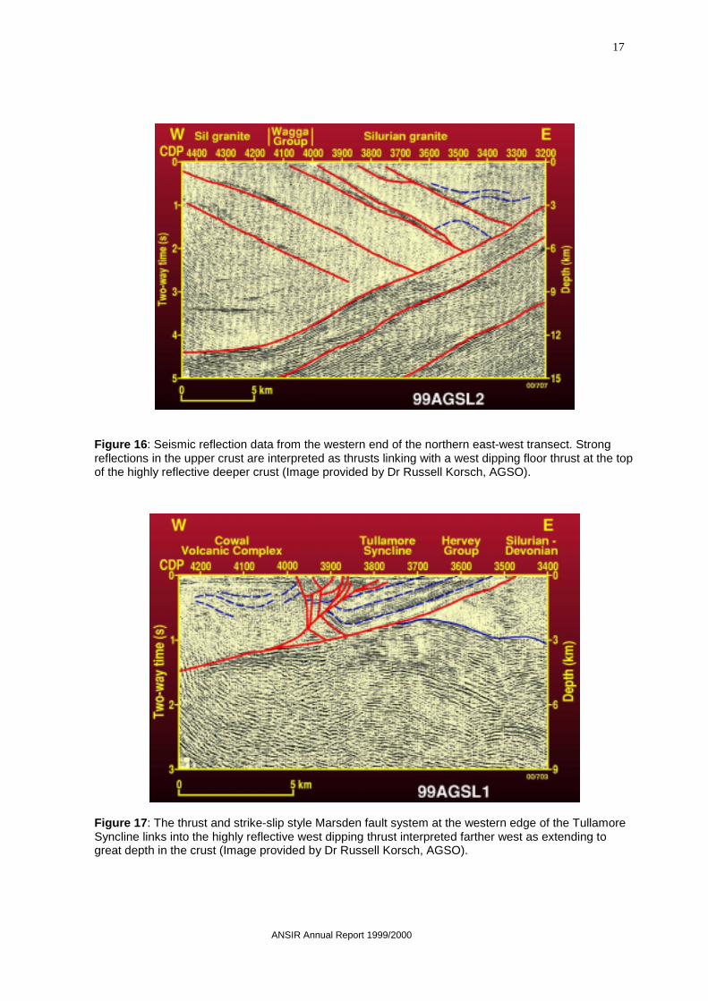
ANSIR recorded three deep seismic reflectionlines as two transects across the fault zone in1999. The positions of these lines are shown inFigure 15. Two higher resolution lines, one ofwhich was co-linear with the regional lines,
were also recorded in an attempt to resolveseveral shallow structures in more detail.
The regional data imaged the geologicalstructures, particularly in the upper crust, withremarkable clarity, as illustrated in Figures 16and 17. These figures show the upper crustfrom parts of the two lines 99AGSL2 and99AGSL1, which together make up thenorthern transect. Note that each figure showsthe data plotted with the same vertical andhorizontal scales, but that the figures do nothave the same scales.
In the west of the transect, along line99AGSL2 (Figure 16), mostly non-reflectiveupper crustal rocks overly highly reflectivedeeper rocks, the top of which is interpreted tobe a major west dipping shear zone (from 3 kmdepth in the east of Figure 16). It forms a floorthrust to reflective east dipping thrusts in themostly unreflective upper crust. Farther east,on line 99AGSL1 (Figure 17), linked thrustand strike-slip faults of the Marsden faultsystem sole at depth onto the west dippingthrust zone.
Figure 15: Geological map of central New South Wales showing the locations of deep seismicreflection profiles overlain on the regional geology (Provided by Dr Russell Korsch, AGSO, andbased on Cootamundra basement interpretation map, NSW DMR).
ANSIR Annual Report 1999/2000
17
Figure 16: Seismic reflection data from the western end of the northern east-west transect. Strongreflections in the upper crust are interpreted as thrusts linking with a west dipping floor thrust at the topof the highly reflective deeper crust (Image provided by Dr Russell Korsch, AGSO).
Figure 17: The thrust and strike-slip style Marsden fault system at the western edge of the TullamoreSyncline links into the highly reflective west dipping thrust interpreted farther west as extending togreat depth in the crust (Image provided by Dr Russell Korsch, AGSO).

18
ANSIR Annual Report 1999/2000
Case Study 5. Eastern Goldfields, Western Australia
This case study is based on information provided in Goleby et al., 2000.
The Eastern Goldfields Province of the ArchaeanYilgarn Block in Western Australia hosts manyworld class gold and nickel deposits. In the lastdecade, seismic reflection imaging by AGSO aspart of the National Geoscience Mapping Accord,and subsequently re-interpreted by the AustralianGeodynamics Cooperative Research Centre, hasbeen pivotal in re-defining the tectonic history ofthe province. The seismic images indicated therole of pervasive, thin-skinned tectonics, and theunderpinning of greenstone supracrustalsequences by a shallow regional detachmentsurface. Although the greenstone sequences aremuch thinner than originally mapped, in placesthey have been thrust into stacks in whichindividual greenstone sequences are repeated.The greenstones host many of the mineraldeposits in the region, and the tectonic model willtherefore have a profound
impact on mineralisation models. Not only is thevolume of greenstones much less than originallyestimated, but the repetition of the greenstonesequences within the thrust stacks means that anygreenstone sequences targeted as host rocks byexploration companies may occur several timesin a region, rather than once.
The AGCRC, with the assistance of ANSIR,revisited the area in 1997 and 1999 to collectmore seismic reflection data. In the 1999 survey,the strategy was to move away from long, linearprofiles to try to develop true three dimensionalmodels of the geometry of the crust, andparticularly the greenstone supracrustalsequences, through the use of networks ofseismic profiles (see Figure 18).
Figure 18: Solid geology map of the southern Eastern Goldfields Province, with the positions ofthe ANSIR deep seismic reflection profiles (black). Earlier regional seismic profiles are also shown(white).

ANSIR Annual Report 1999/2000
19
Results to date indicate that the variations in thewidth and orientation of the Bardoc Shear andother fault systems that form its southernextension are probably associated with variationsin the dip of the fault and topography on the faultsurface. Many gold deposits have a close spatialassociation with the Bardoc Shear. Furtherinterpretation will focus on (a) the distribution offelsic material sandwiched between thedetachment surface and the mafic and ultramaficsequences of the greenstones, because of the
possible role of felsic rocks in the precipitation ofgold from solution, and (b) whether somegranitoid bodies within the greenstone sequencesare magmatically or structurally emplaced. Thelatter is important because structuralemplacement would displace the granites andtheir contained late stage fluids laterally fromtheir source regions.
Preliminary results from the 1999 project werepresented at a workshop in Kalgoorlie in May2000.
Figure 19: Fence diagram showing recent ANSIR data integrated with data from the earlier AGSOregional seismic line. Visualisation of such regional scale datasets challenges most present-daycomputer visualisation systems, not only because of the data volumes but also because of theresolution of the display devices.
Figure 20: The inclusion of smaller-scale windows of data, often using different display parameters,such as black and white rather than colour, can overcome resolution problems encountered whendisplaying the entire data sets. In this example from the 1999 data set, the detachment surface betweenthe greenstone sequences (above) and less reflective crust (below) is clearly imaged.

20
ANSIR Annual Report 1999/2000
FACILITY PROMOTIONANSIR’s promotional strategy has a number ofcomponents targeting not only the scientificcommunity in the Earth sciences, but also thebroader general community.
Twice yearly, ANSIR places articles describingour role in Preview, the newsletter of theAustralian Society of Exploration Geophysicists,The Australian Geologist (Geological Society ofAustralia) and AusGeo News, AGSO’snewsletter. The articles are designed to keepANSIR in the minds of the research community,and particularly to call for project submissions.These newsletters reach the majority of scientistsin the research and industry sectors in Australia,and many overseas scientists.
Newsletter articles are a passive form ofpromotion. Active promotion through personalcontacts is also important for reaching thescientific community.
Both the Director and the Deputy Directorundertake direct promotion at national andinternational conferences. This year, ANSIRtargeted the International Union of Geodesy andGeophysics Meeting in Birmingham England inJuly 1999 (Deputy Director attended), theAustralian Society of Exploration GeophysicistsConference and Technical Exhibition in Perth inMarch (Director), the American GeophysicalUnion Spring Meeting in Washington (DeputyDirector) and the Millennial 9th InternationalSymposium on Deep Seismic Profiling of theContinents and their Margins, in Ulvik, Norway(Director). Researchers are also asked toacknowledge ANSIR’s role in their researchwhen presenting their results at conferences andin formal publications.
The Director has also helped establishCoordinating Committee 8 (CC8) of theInternational Lithosphere Program as a means ofdirectly promoting ANSIR as a resource tointernational researchers. The Director is one ofthree co-chairmen of CC8, which aims to providea mechanism for building links betweenresearchers around the world interested incollaborating in imaging projects.
The Director and Deputy Director travelextensively, and promote ANSIR to the researchgroups they visit. Promotions during this year arelikely to result in research proposals from groupswho have not previously approached ANSIR,including an international collaborative projectbetween the Institute of Geological and NuclearSciences in New Zealand, Cambridge Universityin the United Kingdom and the University ofQueensland. ANSIR introduced the internationalcollaborators to the University of Queensland.
ANSIR researchers and support are proactive inpromoting field activities to the press during fieldexperiments. For example, field work in theEastern Goldfields near Kalgoorlie in WesternAustralia during 1999 was reported in theKalgoorlie Miner. Such reports not only informthe public about why and how field experimentsare undertaken, thereby assisting the fieldoperations through more efficient contacts withan informed public, but also raise the awarenessin the general population of the nature, style andpossible outcomes of seismic imaging research.
Articles about ANSIR projects also appeared inseveral popular magazines this year. AscentTechnology is a magazine produced by theCommonwealth Department of Industry Scienceand Resources, and aims to inform Australiansabout advances in technology and itsapplications. It featured an article about ANSIR’sseismic reflection imaging activities northeast ofBroken Hill in 1998. It stressed that the researchwas driven by practical social objectives, becauseit was assisting Commonwealth and StateGovernment efforts to ensure the longevity of thetown of Broken Hill. Broken Hill’s future isuncertain because ore reserves at the mine aredwindling; this in turn puts the town’s role as aregional economic, educational and health centreunder threat. That article subsequently led to afurther article in the CSIRO-produced Scientrifficmagazine that is aimed at young children.
The ANSIR World Wide Web Page continues tobe an important communication tool forresearchers wishing to contact ANSIR.

ANSIR Annual Report 1999/2000
21

22
ANSIR Annual Report 1999/2000
ANSIR, as a Major National Research Facility,does not have research, education and trainingresponsibilities in its own right, but facilitatesthese activities through the projects it supports,both for its host organisations and for otherinstitutions. The list of personnel associated withANSIR during 1999/2000 given later in thisreport lists researchers working in projects usingdata collected with ANSIR equipment. Theycome from all sectors involved in Earth scienceactivities – industry, universities and governmentsector research.
Most projects are collaborative, and manyinvolve several sectors. ANSIR is proactive indeveloping collaborative projects. The workhighlighted in Case Study 4 above is an example.It resulted from two separate research proposalssubmitted to ANSIR in 1998, which werebrought together into the one field program inwhich the objectives were combined andexpanded through synergy, the project resourceswere pooled, and the results shared. Fundingcame from different levels of government. TheCommonwealth Government through AGSO andthe NSW State Government’s Department ofMineral Resources, through the NSW GeologicalSurvey, and the Cooperative Research CentreProgram, through the AGCRC. The AGCRC hasas its partners AGSO, CSIRO, three universitiesand a computer company. Also additionalfunding from the mining industry, throughNewcrest Mining Limited, provided resources forone field program.
This year also saw further internationalcollaboration between Australian researchers andoverseas groups facilitated by ANSIR. Researchin Papua New Guinea in previous years had beenfostered by ANSIR (Case Study 1), and this yearresearch in Antarctica used ANSIR equipment(Case Study 2).
Education and training in the form ofpostgraduate research based on ANSIR data areoften undertaken in universities other than ANU,one of ANSIR’s host organisations. As such, thiseducation and training effort is at arms lengthfrom ANSIR. However, the ANSIR DeputyDirector's short course on tomography is a directcontribution to education and training, and hasbecome part of the short course curriculumoffered by the Victorian Institute of Earth andPlanetary Sciences (VIEPS), a collaboration ofThe University of Melbourne, Monash Universityand LaTrobe University. This year he presented itto a group of undergraduate and postgraduatestudents, university staff and staff from themineral exploration industry. A list ofpostgraduate students working on ANSIR data isgiven later in the section entitled ‘PersonnelAssociated with ANSIR during 1999/2000’.
Last year AGSO offered its archive of onshoreseismic reflection and refraction data to ANSIRfor distribution to research groups. This year datasets were distributed to a number of universitiesto support student research projects.
COLLABORATION, EDUCATION AND TRAININGOPPORTUNITIES
ANSIR Annual Report 1999/2000
23
Industry interaction with ANSIR continues to bedominated by the resources and energy sectors.In the energy sector, current interaction is withthe coal industry. ANSIR has received researchproposals for future years that will allow us toforge new contacts with the petroleum industryand the electricity generating industry, throughthe imaging of a proposed source of hot dry rockgeothermal energy.
Industry interaction with ANSIR activitiescontinues at several levels of contact, and is listedin Table 4. Company personnel are involved inthe planning of projects, the interpretation ofresults. Companies have also provided fundingand other in-kind support for fieldwork. Allprojects involving industry participants includecollaboration between companies and establishedresearch groups.
Involvement in ANSIRManagementThe ANSIR Board has representatives of theresource and energy industries, nominated by theMinerals Council of Australia and the AustralianPetroleum Production and ExplorationAssociation (APPEA), respectively, who providea strategic overview of ANSIR sponsoredresearch and the opportunities it creates forindustry.
Direct involvementANSIR provides the opportunity for companiesto become directly involved in seismic imagingresearch. The study of earthquake activity near anactive mining area in New South Wales (Project99-04T, see Case Study 3 and Table 4) is anexample. It was proposed and funded by BHPMinerals, Illawarra Coal, and undertaken incollaboration with the CSIRO Division ofExploration and Mining. The project leader isfrom industry. Other projects continuing from
previous years through the data processing andinterpretation phases also have industryparticipation, including the presentation of resultsat conferences and the publication of results. Thestudy of the gold mining district near Kalgoorliein Western Australia (98-07R&T, AGCRCYilgarn Seismic Transect), which was funded byKalgoorlie Consolidated Gold Mines (KCGM) incollaboration with the AGCRC, continues toreceive support through the participation ofcompany geologists in the interpretation andpublication of the data.
Direct involvement includes interaction with theservices industry. Fractal Graphics, a small Perth-based company, has contributed bothvisualisation services and visualisation softwareto the AGCRC to build three dimensionalgeological models of the central Lachlan FoldBelt in New South Wales (Project 98-15R&T,see Case Study 4) and the Eastern Goldfields ofWestern Australia.
Indirect involvementThe majority of industry interactions withANSIR activities comes through input to theplanning of research projects undertaken bygroups who provide pre-competitive informationto support the resource and energy industries.AGSO and the Geological Survey of New SouthWales both consult widely with industry duringthe establishment phases of their work program.They also actively promulgate the results of theirresearch to industry.
Other research groups have industry participantsin their formal management and planningstructures. The AGCRC is an example. It hasindustry representatives on its Board, and itsresearch is developed by Industry AdvisoryPanels that have a focus on regions of highprospectivity and are made up of representativesfrom companies with active exploration programsin each region.
CONTRIBUTION TO AUSTRALIAN INDUSTRY

24
ANSIR Annual Report 1999/2000
TABLE 4: Projects Receiving Industry Support in 1999/2000
Support of Field Program
PROJECT COMPANY NATURE & TYPE OFSUPPORT/INTERACTION
99-06T: The measurement ofseismicity around an activemining area.
BHP Minerals Project management andcollaboration with CSIRO.
98-15R&T: AGCRC Lachlan IISeismicTransect.
Newcrest Pty Ltd. Participated in the design, providedfunding and helped interpret high-resolution component of the transect;provision of drill hole data as in-kindsupport.
Projects for which the field work was undertaken in previous years and data processingand interpretation are ongoing
PROJECT COMPANY NATURE & TYPE OFSUPPORT/INTERACTION
Kimberley Broad Band Trials,WA.
Stockdale Prospecting In-kind provision of logisticsupport for field work in remoteNW Australia.
98-01R: High-resolution seismicimaging of prospectivemineralisation zones near Parkes,NSW.
North Ltd. In-kind provision of logisticsupport for field work.
98-08R&T: AGCRC YilgarnSeismic Transect.
KCGM Pty Ltd. Direct funding of fieldwork,participation in theinterpretation of data,presentation of the results atconferences, and the preparationof publications.
98-15R&T: AGCRC Lachlan IISeismic Transect.
Fractal Graphics Participation in the visualisationof the 3D geology of the centralLachlan Fold Belt, provision ofaccess to visualisation software.

ANSIR Annual Report 1999/2000
25
STAFFING AND ADMINISTRATIONStructure and ManagementANSIR is an unincorporated joint venture ofAGSO and the ANU. The Chief ExecutiveOfficer of AGSO and the Director of theResearch School of Earth Sciences at ANU areadvised on the broad management directions ofANSIR by a Management Advisory Board.Membership of the Board for 1999/2000 is listedin Table 5, and was unchanged from the previousyear. The Board met on 3 occasions during1999/2000 (17 September 1999, 30 March 2000,and 26 May 2000).
Day to day operations are managed by theANSIR Director, Dr Barry Drummond, who isbased at AGSO, and Deputy Director, Prof. BrianKennett at ANU. ANSIR’s Business Managerwas Mr Peter Maher until February 2000, andsubsequently Mrs Joy Dunn, who providedsecretariat services for the Management AdvisoryBoard. ANU provided an Assistant OperationsManager to assist field projects that require thepool of portable instruments. Mr Stefan Sirotjukfilled this position throughout 1999/2000. Keystaff are listed in Table 6. Field projects that usethe pool of reflection equipment housed at AGSOare undertaken by a contracted FacilitiesManager. The current contractor is Terracorp PtyLtd, which was sold during the year and nowtrades as Trace-Terracorp Pty Ltd.
ANSIR calls for research proposals twice eachyear, with calls closing in February and August.In 1999/2000, calls were placed in the scientificmagazines “Preview”, “ The AustralianGeologist” and “AusGeo News”. Proposals arevetted by an Access Committee, which advisesthe Director on the scientific merit of eachproposal. Members of the Access Committee arelisted in Table 7. All proposals received in1999/2000 were considered worthy of support,partly because ANSIR personnel make an effortto interact with the principal investigators to helpthem prepare their proposals to a suitablescientific standard. The ANSIR Director preparesa work plan each year for approval by theManagement Advisory Board at the May meetingprior to the start of each financial year. He alsoprepares a supplementary workplan for theSeptember Board meeting containing anyadditional proposals from the August call forproposals that will be started in the currentfinancial year.
Initiatives of theManagement AdvisoryBoardDuring the year, the Board provided commentson the Department of Education, Training andYouth Affairs Green Paper on research andresearch training, and to the review of Australia’sscience base by the Chief Scientist, Dr RobinBatterham. The Director wrote formal answers toa series of questions posed by the ResourceInfrastructure Consolidation & CooperationWorking Group of the National InnovationSummit Resource. He also attended the summit.All submissions stressed the need to addressshortfalls in the research funding andinfrastructure base identified in the documentTowards 2005: A prospectus for research andresearch training in the Australian earth sciencesprepared by a Working Party of the AustralianGeoscience Council at the request of the Chair ofthe Australian Research Council (ARC), andpublished by the National Board of Employment,Education and Training in 1992. In particular,geophysics research and training is weak inAustralia, despite the dependence of the resourceindustries on geophysical applications.
The weakness in geophysics research andtraining in the Australian university sector isevident in ANSIR research projects. TheManagement Advisory Board notes thatuniversity research funding provided for ANSIRprojects by the Australian Research Councilaccounted for less than 1% of project fieldoperating costs in the three years to June 2000.Throughout this year, the Board developed aworking paper outlining a proposal for a nationalprogram in the Earth sciences. Although such aprogram would be multidisciplinary and involvenot only university researchers and students butalso industry and the government researchsectors, experience overseas has shown that suchprograms, when based around a strong effort inseismic imaging, enhance the broad spectrum ofthe Earth sciences, and not only seismologicalresearch. Support for such a program in Australiawas first articulated in 1982. The ANSIRDirector and the Chairman of the ManagementAdvisory Board have discussed the proposal withresearchers in individual universities, and this hasshown that the support is still strong. ANSIR willcanvas the university sector more broadly during
26
ANSIR Annual Report 1999/2000
the Australian Geological Convention in Sydneyin July 2000.
Both the Director and the Deputy Directorcontinued to be active in both national andinternational science issues throughout the year.The Deputy Director is President of theInternational Association of Seismology andPhysics of the Earth’s Interior, and will give theUnion Address at the Conference of theInternational Union of Geodesy and Geophysicsin Birmingham in July 2000. He is a member ofthe National Committee for the Solid EarthSciences. The Director is Co-Chairman of
Coordinating Committee 8 of the InternationalLithosphere Program, which aims to facilitateinternational communication and collaboration inresearch based on deep geophysical imaging. Heis also a member of a Working Group of theCommonwealth’s Coordinating Committee ofScience and Technology developing a policyframework for the funding and management offuture MNRF’s, and participated in a task forceof the Working Group that considered theadvantages and disadvantages of differentfunding models for MNRF’s.
TABLE 5: ANSIR Management Advisory Board Members, 1999/00:
Prof. John Lovering Board Chairman
Dr Neil Williams
Dr Chris Pigram
Chief Executive Officer, AGSO
Chief, Minerals Division, AGSO
Representing AGSO
An observer, as he is Chief of theDivision in AGSO that hosts the AGSOnode of ANSIR
Prof. David Green
Prof. Brian Kennett
Director, Research School of Earth Sciences, ANU Research School of Earth Sciences, and ANSIR Deputy Director
Representing ANU
As proxy to Prof. Green, representedANU at one Board Meeting during1998/99; otherwise an observer
Dr Barry Drummond ANSIR Director, AGSO
Emeritus Prof. Roye Rutland Kingston, ACT Representing the Commonwealth
Prof. Evan Leitch University of Technology Sydney Representing the ARC Earth SciencePanel and University Research
Dr Graham Price Australian Geodynamics Cooperative ResearchCentre
Representing the CRC Program
Mr Peter Purcell P&R Geological Consultants Pty Ltd, Perth Representing the petroleum industrythrough APPEA
Mr Tom Eadie Pasminco Exploration, Melbourne Representing the Mining Industrythrough the Minerals Council ofAustralia
Mr John Cramsie Director, NSW Geological Survey Representing State and TerritoryGeological Surveys
ANSIR Annual Report 1999/2000
27
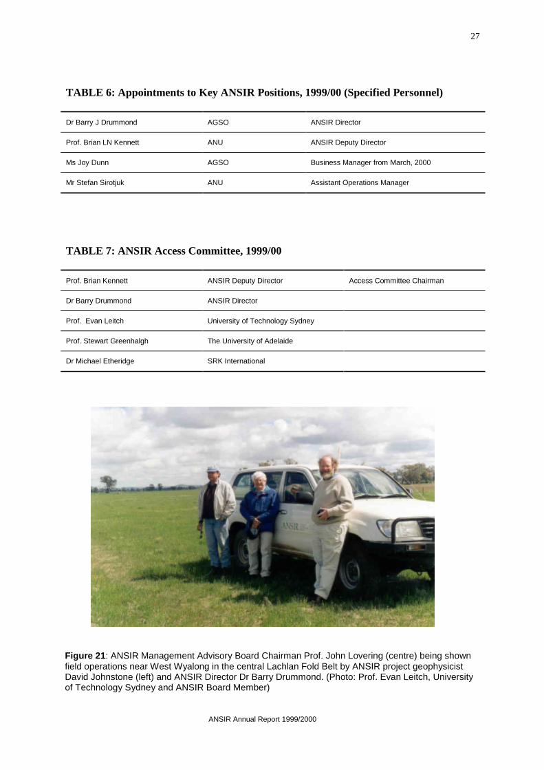
Figure 21: ANSIR Management Advisory Board Chairman Prof. John Lovering (centre) being shownfield operations near West Wyalong in the central Lachlan Fold Belt by ANSIR project geophysicistDavid Johnstone (left) and ANSIR Director Dr Barry Drummond. (Photo: Prof. Evan Leitch, Universityof Technology Sydney and ANSIR Board Member)
TABLE 6: Appointments to Key ANSIR Positions, 1999/00 (Specified Personnel)
Dr Barry J Drummond AGSO ANSIR Director
Prof. Brian LN Kennett ANU ANSIR Deputy Director
Ms Joy Dunn AGSO Business Manager from March, 2000
Mr Stefan Sirotjuk ANU Assistant Operations Manager
TABLE 7: ANSIR Access Committee, 1999/00
Prof. Brian Kennett ANSIR Deputy Director Access Committee Chairman
Dr Barry Drummond ANSIR Director
Prof. Evan Leitch University of Technology Sydney
Prof. Stewart Greenhalgh The University of Adelaide
Dr Michael Etheridge SRK International
28
ANSIR Annual Report 1999/2000
Enhancing the FacilityBoth the portable instrument pool and thereflection seismic equipment pool were enhancedduring the year. The upgrade of the short periodportable instruments to 16-bit sample sizecontinued. This allows the instruments to recorda greater dynamic range than previously possible.Extra cables and geophones were ordered for thereflection recording equipment. These will allowmore cost-efficient high resolution imaging, highresolution imaging in a wider range of geologicalconditions, and more reliable performance inareas with highly attenuating near surfaceconditions. They will also allow high resolutionlines to be recorded simultaneously with regional
scale lines by using the multi-line capability ofANSIR’s ARAM24 recording system. Inanticipation of the needs of several projects thathave been proposed for next year, ANSIR hasalso purchased additional electronics andsoftware that will capture the (GPS-based)absolute time of each sweep of our vibratoryseismic sources. This will allow the vibratorysources to be used more efficiently with our shortperiod portable instruments. With this purchase,we are moving closer to being able to fullyintegrate our pools of portable recorders andreflection seismic equipment in a singleexperiment.
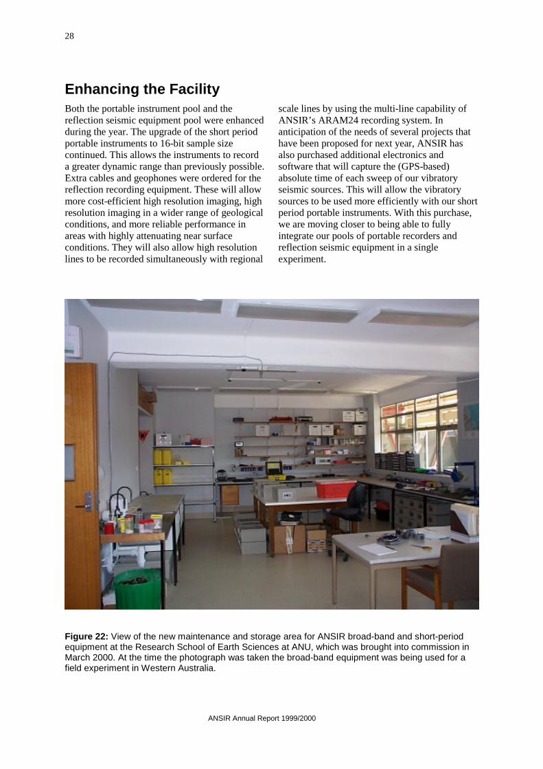
Figure 22: View of the new maintenance and storage area for ANSIR broad-band and short-periodequipment at the Research School of Earth Sciences at ANU, which was brought into commission inMarch 2000. At the time the photograph was taken the broad-band equipment was being used for afield experiment in Western Australia.

ANSIR Annual Report 1999/2000
29
GRANTS AND AWARDSANSIR is not aware of any grants or awards from traditional university funding sources, particularlythe ARC that helped fund fieldwork with ANSIR equipment in 1999/2000.
Table 8 lists funds from other sources.
TABLE 8: Other Project FundsThis table reflects project funds paid into and expended from the ANSIR accounts held by AGSO asFacility Agent.
Project and Title Researcher Funding Source Duration Value
98-15R: AGCRC Lachlan IISeismic Transect
AGCRC/AGSORussell Korsch
AGCRC
NSW DMR
Newcrest Mining
1 Year $ 292 185
$ 120 000
$ 18 045
98-07R: AGCRC Yilgarn SeismicTransect
AGCRC/AGSOBruce Goleby
AGCRC 1 Year $ 437 900

30
ANSIR Annual Report 1999/2000
PERFORMANCE INDICATORS AND PERFORMANCEMEASURESPerformance Indicators and Performance Measures are set out in the agreements AGSO and ANUsigned with the Commonwealth to establish ANSIR. It was envisaged that not all PerformanceIndicators would be achieved every year, but that all would be achieved over the life of the Facility.Table 9 below summarises the performance indicators, and the comments are designed to indicate howANSIR addressed the Performance Measures in 1999/2000. Ticks show those Performance Indicatorsfor which significant progress was achieved during the year.
TABLE 9: Performance Indicators and Performance Measures
PERFORMANCE INDICATOR Achieved 99/00
COMMENT
Progress achieved
✔ This was our first full year of operations. All elements of ANSIRequipment were used in research projects that included theuniversity and government research sectors and industry.
Our formal calls for project proposals resulted in projects thatmove us into new areas of research, including alternative energysources.
ANSIR research projects covered large areas of southeastAustralia and Western Australia, and were conducted at a rangeof scales.
Our first experiment with broad band portable instruments in thechallenging environment of Antarctica was successful. It alsoextended the international collaboration on ANSIR-supportedprojects to include New Zealand.
Although the bulk of ANSIR equipment was in place at the startof the year, development and enhancement of the facilitycontinued, with upgrades to our short period portableinstruments, and additional geophones and cables purchased forthe reflection recording equipment. Additional electronics andsoftware purchased this year will facilitate the use of ourvibratory energy sources with our short period portablerecorders.
Advances to knowledge, education and training, and social and economic development
✔
Research based on ANSIR data was presented at a number ofimportant conferences, including:• A conference of the International Union of Geodesy and
Geophysics in Birmingham, England;• the Millenial 9th International Symposium on Deep Seismic
Profiling of the Continents and their Margins in Ulvik,Norway; and
• The Conference of the Australian Society of ExplorationGeophysicists in Perth.
ANSIR projects made significant contributions to understandingand revising the geology of a number of parts of Australia,including:• better definition of the district scale structures near
Kalgoorlie in Western Australia, including an attempt toimage the three dimensional architecture of key featuresthrough the use of networks of two dimensional images; and
• images at several scales of features in the central LachlanFold Belt in New South Wales.
Deployments of ANSIR broadband portable instruments insoutheast Australia and Antarctica will contribute new knowledgeon the lithospheric structure in those areas

ANSIR Annual Report 1999/2000
31
The number of postgraduate students using ANSIR data for theirresearch projects grew slightly. The regions being studied rangefrom large portions of the continent to old river channels severalhundred metres wide.
The Deputy Director’s short course based on his published texton seismic tomography was presented at Monash University to amixed group of postgraduate students, university researchersand lecturers and industry geophysicists.
The list of publications based on ANSIR-supported researchcontinues to grow.
Facility promotion ✔ ANSIR moved to two calls for research proposals each year, inFebruary and August.
The facility was promoted through attendance of the ANSIRDirector and Deputy Director at several national andinternational conferences, listed above.
The ANSIR Director is a co-chairman of a new CoordinatingCommittee of the International Lithosphere Program providingan avenue for promoting ANSIR as a research facility to theinternational research community.
ANSIR featured in several articles in magazines for non-technical, non-scientific readers.
The ANSIR Web page continued to prove a valuable avenue fordistributing ANSIR information.
Contribution to enhancingAustralia’s prestige
✔ The use of ANSIR’s broad band portable instruments in a projectin Antarctica allowed us to extend the international collaborationbased on ANSIR data to New Zealand.
The research results and the quality of data presented in papersat the international conferences listed above were of high qualitywhen benchmarked against the efforts of peer researchers fromoverseas.
Contribution to researchlinkages
✔ All ANSIR projects involve collaboration between researchgroups, or between industry and research groups.
ANSIR was able to facilitate links between Australianresearchers seeking to work on similar topics. The project in thecentral Lachlan Fold Belt (Case Study 4) was based on twoproposals originally submitted to ANSIR, and ultimately usedfunding from 4 sources: the Cooperative Research CentresProgram, AGSO, the NSW State Government and a mineralexploration company.
Contribution to Australianindustry
✔ Staff from exploration companies actively collaborated in severalprojects; their companies provided in-kind support for fieldexperiments. Papers authored by industry staff are now beingprepared for the scientific press.
Collaboration extended to service companies which contributedto the visualisation research results and their promulgation to theexploration sector.
A number of small service companies provided consultancy andcontract services to seismic reflection field operations.
32
ANSIR Annual Report 1999/2000
Enhancing the Facility ✔ The ANSIR Board pursued the objective of “providing nationalleadership, international visibility and collaboration in communityservice through the use and operation of world class facilities forseismological research” by:• contributing to the debate on science issues in Australia
through submissions to a number of reviews anddiscussions of Australia’s science base; and
• developing a proposal for a multidisciplinary, multi-sectornational program in the Earth sciences, and starting theprocess of taking the program to the university sector.
Promoting the objectives ofthe MNRF Program
✔ All efforts to promote ANSIR and our research results, andsubmissions to national reviews of the science base, havestressed the role of the MNRF Program in developing ANSIR.
ANSIR emphasises that its projects contribute to the economic,environmental and social well being of Australians.
ANSIR Annual Report 1999/2000
33
PUBLICATIONS 1999/2000
Bai, C-Y. & Kennett, B.L.N., 2000. Automatic phase-picking and identification by full use of a single three-component broadband seismogram. Bulletin of theSeismological Society of America, 90, 187-198.*
Clitheroe, G., Gudmundsson, O. & Kennett, B.L.N.,2000. The crustal thickness of Australia. Journal ofGeophysical Research, 105, 13697-13713.
Deen, T.J., Gohl, K., Leslie, C., Papp, E. & Wake-Dyster, K., 2000. Seismic refraction inversion of apalaeochannel system in the Lachlan Fold Belt,central New South Wales. Exploration Geophysics,31, 389-393.
Drummond, B.J., Goleby, B.R., Barton, T.J. &Korsch, R.J., 2000. The Moho as a detachmentsurface. 9th International Symposium on DeepSeismic Profiling of the Continents and their Margins,Ulvik, Norway, 18-23 June, 2000, Abstracts, 93.
Drummond, B.J., Cox, S.F. & Goleby, B.R., 2000.The role of fluids in the formation of regional-scaledetachment surfaces. 9th International Symposium onDeep Seismic Profiling of the Continents and theirMargins, Ulvik, Norway, 18-23 June, 2000, Abstracts,51.
Dunne, J.C., Beresford, G. & Kennett, B.L.N., 2000.Guidelines for building a detailed elastic depth model.Geophysics, 65, 35-45.*
Finlayson, D. M., Gudmundsson, O., Johnson, R.W.,Itikarai, I., Shimamura, H. & Nishimura, Y., 1999.Wide-angle seismic profiling across the Rabaulvolcano: a framework for tomographic imaging ofcaldera architecture. International Union of Geodesyand Geophysics General Assembly, Birmingham,U.K., Abstracts B, 152.
Furumura, M., Kennett, B.L.N. & Furumura, T.,1999. Seismic wavefield calculation for laterallyheterogeneous Earth models II - the effect of uppermantle heterogeneity. Geophysical JournalInternational, 138, 623-644.*
Gohl, K., 1999. Report of Seismic Reflection Surveyat North Parkes Mine, Central NSW by MacquarieUniversity, Sydney Australian Geological SurveyOrganisation, Record, 1999/57.
Goleby, B.R., Korsch, R.J., Drummond, B.J., Fomin,T., Owen, A.J. & Bell, B., 2000. Three dimensionalcrustal structure from deep seismic reflection data inthe Archaean granite-greenstone Yilgarn Craton,Western Australia. 9th International Symposium onDeep Seismic Profiling of the Continents and theirMargins, Ulvik, Norway, 18-23 June, 2000, Abstracts,52.
Goleby, B.R., Korsch, R.J., Sorjonen-Ward, P.,Groenewald, P.B., Bell, B., Wyche, S., Bateman, R.,Fomin, T., Drummond, B.J. & Owen, A.J., 2000.Crustal structure and fluid flow in the EasternGoldfields, Western Australia. Workshop on Resultsfrom the AGCRC’s Yilgarn Deep Seismic ReflectionSurvey and Fluid Flow Modelling Projects. 87p, 20Colour Figures. Australian Geological SurveyOrganisation, Record, 2000/34.
Goncharov, A., O’Brien, G. & Drummond, B.J.,2000. Seismic velocities in the North West Shelfregion, Australia, from near-vertical and wide-anglereflection and refraction studies. ExplorationGeophysics, 31, 347-352.*
Gudmundsson, O., Finlayson, D.M., Itikarai, I.,Shimamura, H., Nishimura, Y., & Johnson, R. W.,1999. P-velocity tomography of shallow structurebeneath Rabaul caldera based on local earthquake andexplosion data. International Union of Geodesy andGeophysics General Assembly, Birmingham, U.K.,Abstracts B, 152.
Kaiho, Y. & Kennett, B.L.N., 2000. Three-dimensional seismic structure beneath theAustralasian region from refracted wave observations.Geophysical Journal International, 142,
Kennett, B.L.N., 2000. Crust and lithosphere fromseismic observations. In J.J. Veevers (Editor) Billion-year earth history of Australia and neighbours inGondwanaland. Gemoc Press, Sydney, 74-77.
Kennett, B.L.N., 2000. Stacking 3-componentseismograms. Geophysical Journal International, 141,263-269.*
Kleffmann, S., Hackney, R., Hollingsworth, D.,Goleby, B.R., Dentith, M. & Powell, C., 2000. Deepseismic reflection profiling of the ProterozoicHamersley Province, Western Australia. 9thInternational Symposium on Deep Seismic Profilingof the Continents and their Margins, Ulvik, Norway,18-23 June, 2000, Abstracts, 121.
Korsch, R.J., Glen, R.A., Jones, L.E.A., Johnstone,D.W., Finlayson, D.M., & Lawrie, K.C., 2000. Deepseismic imaging of an ancient convergent platemargin, eastern Lachlan Orogen, Australia. 9th
International Symposium on Deep Seismic Profilingof the Continents and their Margins, Ulvik, Norway,18-23 June, 2000, Abstracts, 52.
Korsch, R.J., Barton, T.J., Drummond, B.J.,Finlayson, D.M., Fomin, T., Goleby, B.R., Johnstone,D.W., Jones, L.E.A., Mifsud, J. & Owen, A.J., 2000.Crustal thrust systems in the Phanerozoic Tasmanorogenic system, eastern Australia. 9th InternationalSymposium on Deep Seismic Profiling of theContinents and their Margins, Ulvik, Norway, 18-23June, 2000, Abstracts, 82.
34
ANSIR Annual Report 1999/2000
Leslie, C., Jones, L.E.A, Papp, E, Wake-Dyster, K.,Deen, T.J., & Gohl, K., 2000. High-resolution seismicimagery of palaeochannels near West Wyalong, NewSouth Wales. Exploration Geophysics, 31, 383-388.
Palmer, D., Goleby, B.R. & Drummond, B.J, 2000.The effects of sampling on refraction statics.Exploration Geophysics, 31, 270-274.
Sato, T. & Kennett, B.L.N., 2000. Two-dimensionalrefraction inversion by progressive modeldevelopment. Geophysical Journal International, 140,543-558.
Spassov, E. & Kennett, B.L.N., 2000. Stress andfaulting in southeast Australia as derived from thestrongest earthquakes in the region. Journal of AsianEarth Science, 18, 17-23.*
Terracorp, 1999a. 1999 CABGAS Seismic Survey,Darling Basin, NSW - Field Acquisition andOperations Report for ANSIR. Australian GeologicalSurvey Organisation, Record, 1999/54.
Terracorp, 1999b. 1999 Yilgarn Seismic Survey,Kalgoorlie/Boulder, WA - Field Acquisition andOperations Report for ANSIR. Australian GeologicalSurvey Organisation, Record, 1999/55.
Terracorp, 1999c. 1999 Lachlan and Marsden SeismicSurvey, West Wyalong, NSW - Field Acquisition andOperations Report for ANSIR Australian GeologicalSurvey Organisation, Record, 1999/56.
Widiyantoro, S., Gorbatov, A., Kennett, B.L.N. &Fukao, Y., 2000. Improving global shear-wave delay-time tomography using three-dimensional ray tracingand iterative inversion. Geophysical JournalInternational, 141, 747-758.
Widiyantoro, S., Kennett, B.L.N. & van der Hilst,R.D., 1999. Seismic tomography with P and S datareveals lateral variation in the rigidity of deep slabs.Earth and Planetary Science Letters, 173, 91-100.
Willcox, B., Johnstone, D., Wake-Dyster, K., Leven,J., Yeates, A., Mills, K. & Shaw, R., 2000. A deep-crustal seismic image through the Bancannia Troughand Koonenberry Zone, New South Wales. ASEGPreview, February 2000, 114 (abstract).
Publications in press
Bai, C-Y. & Kennett, B.L.N., 2000. Phaseidentification and attribute analysis of broadbandseismograms at far-regional distances. Journal ofSeismology.
Bell, B., Goleby, B.R., Fomin, T., Owen, A.J. &Korsch, R.J., 2000. Detailed gravity as an aid forconstraining crustal structures interpreted from deepseismic reflection profiling within the EasternGoldfields, Western Australia. 15th AustralianGeological Convention, Sydney, 3-7 July, 2000,Abstracts, 59.
Clitheroe, G., Gudmundsson, O. & Kennett, B.L.N.,2000. Sedimentary and upper-crustal structure ofAustralia from receiver functions, Australian Journalof Earth Science, 153.
Collins, C. & Drummond, B.J., 2000. Crustalthickness patterns in the Australian Continent. 15th
Australian Geological Convention, Sydney, 3-7 July2000, Abstracts, 59.
Debayle, E. & Kennett, B.L.N., 2000. The Australiancontinental upper mantle - structure and deformationinferred from surface waves. Journal of GeophysicalResearch.
Dentith, M.C., Dent, V.F. & Drummond, B.J., 2000,Deep crustal structure in the southwestern YilgarnCraton, Western Australian Tectonophysics, inpress.*
Direen, N.G., Archibald, N.J., Hill, E.J., Mackey,T.E., Raymond, O.L., Lyons, P., Korsch, R.J. &Holden, D.J., 2000. “Annelidical Geometry” – A 3-Dgeological and geophysical appraisal of majorstructures in the eastern Lachlan Orogen using multi-scale edge analysis. 15th Australian GeologicalConvention, Sydney, 3-7 July, 2000. Abstracts, 59.
Drummond, B.J., Goleby, B.R., Owen, A.J., Yeates,A.N., Swager, C., Zhang, Y. & Jackson, J.K., 2000.Seismic reflection imaging of mineral systems; threecase histories. Geophysics.*
Drummond, B.J., Goleby, B.R. & Swager, C.P., 2000.Crustal signature of late Archaean tectonic episodes inthe Yilgarn Craton, Western Australia: evidence fromdeep seismic sounding. Tectonophysics.*
Drummond, B.J., Owen, A.J., Jackson, J.C., Goleby,B.R. & Sheard, S.N., 2000. Seismic reflectionimaging of the environment around the Mount Isa orebodies, northern Australia – A case study.Geophysics.*
Drummond, B.J., Barton, T.J., Korsch, R.J.,Rawlinson, N., Yeates, A.N., Collins, C.D.N. &Brown, A.V., 2000. A new passive margin model forthe Neoproterozoic and early Palaeozoic of Tasmania,Australia. Tectomnophysics*.
Glen, R.A., Korsch, R.J., Jones, L.E.A. & Johnstone,D.W., 2000. Seismic evidence for a major arc-backcollision in the Lachlan Orogen. 15th AustralianGeological Convention, Sydney, 3-7 July, 2000,Abstracts, 59.
Goleby, B.R., Bell, B., Korsch, R.J., Fomin, T.,Owen, A.J., Nicoll, M.G. & Drummond, B.J., 2000.Towards the third dimension in the EasternGoldfields, WA from combined seismic reflectionand potential field studies. 15th Australian GeologicalConvention, Sydney, 3-7 July, 2000, Abstracts, 59.

ANSIR Annual Report 1999/2000
35
Goleby, B.R., Drummond, B.J., Korsch, R.J., Fomin,T., Owen, A.J. & Bell, B., 2000. Crustal structure –thrust stacks and gold pathways within the Archaeangranite-greenstones of the Eastern Goldfields,Western Australia: as revealed by deep seismicreflection profiling. 15th Australian GeologicalConvention, Sydney, 3-7 July, 2000, Abstracts, 59.
Goncharov, A., Kennard, J., Colwell, J., Fomin, T.,Kritski, A., Petkovic, P., Symonds, P. & Sayers, J.,2000. Towards improved understanding of the deepstructure of the Australian northwest margin fromcombined refraction/reflection seismic studies. 15th
Australian Geological Convention, Sydney, 3-7 July,2000, Abstracts, 59.
Graeber, F.M., Houseman, G.A. & Greenhalgh, S.A.,2000. The three-dimensional upper mantle P-wavevelocity structure of western Victoria. 15th AustralianGeological Convention, Sydney, 3-7 July, 2000,Abstracts, 59.
Hatherly, P., Poole, G. & Xun, L., 2000. Seismicity inthe Appin area of NSW and its association withmining activities. Proceedings of the AustralianEarthquake Engineering Society Conference,November, 2000.
Kennett, B.L.N., 2000. The Mantle BeneathAustralia. 15th Australian Geological Convention,Sydney, 3-7 July, 2000, Abstracts, 59.
Kennett, B.L.N. & Ringdal, F. Locating seismicevents in a CTBT context. Pure and AppliedGeophysics.
Korsch, R.J., Lawrie, K.C., Johnstone, D.W. & Jones,L.E.A., 2000. A deep seismic reflection profile acrossthe Gilmore Fault, Eastern Lachlan Orogen. 15th
Australian Geological Convention, Sydney, 3-7 July,2000, Abstracts, 59.
Marson-Pidgeon, K. & Kennett, B.L.N., 2000.Flexible computation of teleseismic synthetics forsource and structural studies. Geophysical JournalInternational.
Sambridge, M.S. & Kennett, B.L.N., 2000. Seismicevent location: nonlinear inversion using aneighbourhood algorithm. Pure and AppliedGeophysics.
* Publications by ANSIR Researchers whichare not based on data collected with ANSIRequipment, but serve to promote ANSIR as acentre of excellence.

36
ANSIR Annual Report 1999/2000
PERSONNEL ASSOCIATED WITH ANSIR DURING1999/2000
The following personnel were associated with ANSIR during 1999/00. Those listed under “ProjectResearchers” and “Postgraduate Students” participated in research projects, and were not involved inthe day-to-day management and operations of ANSIR.
ANSIR Specified Personnel
Dr Barry J. Drummond ANSIR Director AGSOProf. Brian L.N. Kennett ANSIR Deputy Director ANUMr Peter Maher Business Manager AGSO until March 2000Ms Joy Dunn Business Manager AGSO from March 2000Mr Stefan Sirotjuk Assistant Operations Manager ANU
Project Researchers (Researchers from AGSO, ANU or third parties who participated in projectsusing data collected in whole or in part with ANSIR equipment)
Dr S. Bannister Institute of Geological & Nuclear Sciences, New ZealandDr Roger Bateman Kalgoorlie Consolidated Gold Mines Pty LtdProf. M. Cara University of StrasbourgDr G. Clitheroe US Geological SurveyMr Clive Collins AGSODr Fred Davey Institute of Geological & Nuclear Sciences, New ZealandDr E. Debayle RSES, ANUDr Barry Drummond AGSODr Douglas Finlayson AGSO and AGCRCDr Richard Glen NSW Department of Mineral Resources, Geological SurveyDr Karsten Gohl Macquarie UniversityDr Bruce Goleby AGSODr E. Graeber Monash UniversityDr O. Gudmundsson RSES, ANUDr Peter Hatherley CSIRO Exploration and MiningMr Patrick Henry Rabaul Volcanological ObservatoryAssoc. Prof. Greg Houseman Monash UniversityMr John Holliday Newcrest Mining Pty LtdDr Imi Itikarai Rabaul Volcanological ObservatoryDr Wally Johnson AGSODr Leonie Jones AGSO and AGCRCProf Brian LN Kennett ANUDr Ken Lawrie AGSODr James Leven AGSO and AGCRCDr J. J. Leveque University of StrasbourgMr Fraser MacCorquodale Newcrest Mining Pty LtdMr Phil McInerney North LimitedDr Y. Nishimura Hokkaido University, JapanDr Eva Papp ANU (Geology) and CRC LEMEMr Greg Poole BHP CoalProf. Lee Powell University of Wisconsin, USADr Ray Shaw Consultant to NSW Department of Mineral ResourcesProf Hideki Shimamura Hokkaido University, JapanMr Stuart Smith North LimitedProf. Cliff Thurber University of Wisconsin, USA

ANSIR Annual Report 1999/2000
37
Mr Barry Willcox AGSOMr Tony Yeates AGSO
Postgraduate Students
Mr John Bus Macquarie UniversityMs Tara Deen Macquarie UniversityMr Ron Hackney Tectonics Special Research Centre, University of WAMr David Hollinsgworth Curtin University of TechnologyMr Christopher Leslie ANU and CRC LEMEMrs K. Marson-Pidgeon RSES, ANUMr K. Yoshizawa RSES, ANU
Scientific Support Staff
Mr Tim Barton Geophysicist AGSOMr David Johnstone Geophysicist AGSOMr Andrew Owen Geophysicist AGSO
Technical Support Staff
Mr Armando Arcidiaco Technical Officer ANU 20%Mr Alan Crawford Mechanic AGSO 100%Mr Tony Percival Technical Officer ANU 30%
Temporary Field Staff as required
Service Companies:
Function/Project Company Nature of Service
Facilities Management Services Trace-Terracorp Pty Ltd Operate Seismic ReflectionEquipment housed at AGSO –from August 1998.
Lachlan II Seismic Transect Hampton Transport Services
Dynamic Satellite Services
Line preparation contract.
Surveyors.
Yilgarn Seismic Transect Quartermaine Consultants
TPV Excavations
Dynamic Satellite Services
Investigation for AboriginalSites.
Line preparation contract.
Surveyors.

38
ANSIR Annual Report 1999/2000
Contact Details
Dr Barry Drummond (ANSIR Director)Australian Geological Survey OrganisationGPO Box 378Canberra ACT 2601
Tel 02-6249 9381Fax 02-6249 9972Email [email protected]
Prof. Brian Kennett (ANSIR Deputy Director)Research School of Earth SciencesAustralian National UniversityCanberra ACT 0200
Tel 02-6249 4621Fax 02-6257 2737Email [email protected]
Mr Peter Maher (ANSIR Business Manager until March 2000)Australian Geological Survey OrganisationGPO Box 378Canberra ACT 2601
Tel 02-6249 9558Fax 02-6249 9972Email [email protected]
Ms Joy Dunn (ANSIR Business Manager from March 2000)Australian Geological Survey OrganisationGPO Box 378Canberra ACT 2601
Tel 02-6249 9364Fax 02-6249 9972Email [email protected]

ANSIR Annual Report 1999/2000
39
List of Acronyms
ANSIR Australian National Seismic Imaging Resource
AGSO Australian Geological Survey Organisation
ANU Australian National University
AGCRC Australian Geodynamics Cooperative Research Centre
APPEA Australian Petroleum Production and Exploration Association
ARC Australian Research Council
AGU American Geophysical Union
ASEG Australian Society for Exploration Geophysicists
BHEI Broken Hill Exploration Initiative
COILS Committee for Coordinating Interdisciplinary Lithospheric Studies
CSIRO Commonwealth Scientific Industrial Research Organisation
CRC LEME Cooperative Research Centre for Landscape Evolution and Mineral Exploration
KCGM Kalgoorlie Consolidated Gold Mines Ltd
MNRF Major National Research Facility
RSES Research School of Earth Sciences, ANU
TSRC Tectonics Special Research Centre
VIEPS Victorian Institute of Earth and Planetary Sciences