annual report - beslter.org · dr. richard v. pouyat, usda forest service dr. emma j....
TRANSCRIPT

Annual Report
2010
Covering
August 2009—August 2010
Urban LTER: Human Settlements as Ecosystems: Metropolitan Baltimore from 1797 – 2100
August 2010
www.beslter.org

Baltimore Ecosystem Study Annual Report 2010 ____________________________________________________________________________________________
__________________________________________________________________________________ An Urban LTER 2 August 2010
Preface to the Annual Report On the following pages is the Annual Report of the Baltimore Ecosystem Study (BES) for the period 2009-20010. The Baltimore Ecosystem Study, a Long-Term Ecological Research (LTER) project, was initiated in 1997. The BES is one of 26 LTER projects, representing diverse ecosystems and research emphases. It is funded by the National Science Foundation to learn how an urban area works as an ecological system. Over the last nine years we have learned new, and sometimes surprising, things about Baltimore’s urban ecosystem. This report summarizes the most recent scientific and educational contributions BES has made. As one of only two Long-Term Ecological Research sites focused on an urban environment, we want to know the ecological interactions in the whole range of habitats—from the center city of Baltimore, to the surrounding rural areas. We are conducting research on the soil, the plants and animals on land and in the streams, the water quality, and condition of the air in and around Baltimore. For that information to make sense, we are also studying how families, associations, organizations and political bodies make decisions that affect ecological processes. In other words, we are treating the whole collection of city, suburban and rural areas as a complex urban ecological system that includes people and their activities. This is a really unusual approach to ecology because it combines with social sciences, physical sciences, and education to understand a big metropolitan area as an ecological system. Saying that an urban area is a system just means that we are concerned with the interactions between wild and domestic organisms, people and their organizations, the natural and built environment, and how they all affect one another. It is these relationships that determine the quality of the environment we experience. The program brings together researchers from many disciplines and organizations to collect new data and synthesize existing information on both the ecological and engineered systems of Baltimore. Our interest is not only with the present environment, but with the historical changes that have led to the conditions that exist today, and with the environmental trends into the future. The ecological knowledge BES creates helps support educational and community-based activities. Indeed, the interactions between our researchers and the Baltimore community are important components of our project. We hope that the information produced by our work, which integrates many disciplines and the efforts of many research and educational institutions in Baltimore and beyond, is of interest and use to you. You may contact the researchers, educators, and professional members of the Baltimore Ecosystem Study through the Project Facilitator, Holly Beyar ([email protected]), and locate updated information and additional information on the project through its website ( http://www.beslter.org ). Steward T.A. Pickett, BES Project Director and Principal Investigator Cary Institute of Ecosystem Studies Box AB Millbrook NY 12545

Baltimore Ecosystem Study Annual Report 2010 ____________________________________________________________________________________________
__________________________________________________________________________________ An Urban LTER 3 August 2010
Acknowledgement of Support The Baltimore Ecosystem Study project is supported by the National Science
Foundation Long-Term Ecological Research program, grant number DEB 0423476.
The USDA Forest Service Northern Research Station contributes research staff time,
equipment, funds and in kind services to BES. In addition we thank the University
of Maryland, Baltimore County for their contribution to office, laboratory and field
space at the Center for Urban Environmental Research and Education. The US
Geological Survey, the City of Baltimore Department of Recreation and Parks, the
Baltimore City Department of Public Works, the Baltimore County Department of
Parks, the Baltimore County Department of Environmental Protection and Resource
Management, the Maryland Department of Natural Resources, and the McDonogh
School all kindly provide access or management of land and equipment used by the
Baltimore Ecosystem Study for ecological, hydrological, and meteorological field
studies. The USDA ARS Environmental Microbial Safety Lab contributes resources
for water pathogen analysis. Additional support and assistance has been provided
by many agencies, communities and individuals who are listed in the report.
Acknowledgment and Disclaimer
"This research was supported by funding from the NSF Long-term Ecological Research (LTER) Program." "This material is based upon work supported by the National Science Foundation under Grant No. 0423476." "Any opinions, findings, and conclusions or recommendations expressed in this material are those of the author(s) and do not necessarily reflect the views of the National Science Foundation."

Baltimore Ecosystem Study Annual Report 2010 ____________________________________________________________________________________________
__________________________________________________________________________________ An Urban LTER 4 August 2010
Table of Contents Preface to the Annual Report ......................................................... 2
Acknowledgement of Support ........................................................ 3
Participants
People ......................................................................... 5 – 12
Organizations ............................................................... 12 – 15
Activities ............................................................................. 16 – 46
Outreach ............................................................................. 46 – 62
Presentations ................................................................ 52 – 57
Posters .............................................................................. 58
Websites ...................................................................... 59 – 62
Findings .............................................................................. 63 – 79
Contributions ....................................................................... 80 – 89
Publications and Products
Journal Publications ....................................................... 89 – 93
Books and Book Chapters ............................................... 93 – 95
Report to Agency or Organization .......................................... 95
Theses/Dissertations ..................................................... 95 – 96
Abstracts .................................................................... 96 – 103
Other Publications Related to BES Work ................................. 103
Magazine Articles ............................................................... 103
Newspaper Articles ............................................................. 103
Databases ......................................................................... 104
Educational Products .......................................................... 104
Other Products ......................................................... 104 – 105
Baltimore Ecosystem Study Annual Report 2010 ____________________________________________________________________________________________
__________________________________________________________________________________ An Urban LTER 5 August 2010
Participants
Project Director: Dr. Steward T.A. Pickett, Cary Institute of Ecosystem Studies Co-Principal Investigators Dr. Daniel J. Bain, University of Pittsburgh Dr. Lawrence E. Band, University of North Carolina, Chapel Hill Mr. Kenneth T. Belt, USDA Forest Service Dr. Alan R. Berkowitz, Cary Institute of Ecosystem Studies Dr. Christopher G. Boone, Arizona State University Dr. Grace S. Brush, The Johns Hopkins University Dr. Geoffrey L. Buckley, Ohio University Dr. Mary L. Cadenasso, University of California, Davis Ms. Jacqueline M. Carrera, Parks & People Foundation, Inc. Dr. Shawn E. Dalton, University of New Brunswick Mr. Edward J. Doheny, US Geological Survey Dr. Kirstin Dow, University of South Carolina Dr. Emily M. Elliott, University of Pittsburgh Dr. Erle C. Ellis, University of Maryland, Baltimore County Dr. Peter M. Groffman, Cary Institute of Ecosystem Studies Dr. J. Morgan Grove, USDA Forest Service Dr. Gordon M. Heisler, USDA Forest Service Dr. Quintaniay Holifield, USDA Forest Service Dr. John L. Hom, USDA Forest Service Dr. Elena G. Irwin, Ohio State University Dr. Sujay S. Kaushal, University of Maryland, Earth System Science
Interdisciplinary Center Laboratory Dr. Shannon L. LaDeau, Cary Institute of Ecosystem Studies Dr. Neely L. Law, Center for Watershed Protection Mr. Charles P. Lord, Urban Ecology Institute Dr. Paul Mayer, US Environmental Protection Agency Mr. Brian P. McGrath, Urban-Interface, Parsons-The New School for Design Dr. Andrew J. Miller, University of Maryland, Baltimore County Dr. Robert J. Neff, University of Maryland, Baltimore County Dr. Charles H. Nilon, University of Missouri, Columbia Dr. David J. Nowak, USDA Forest Service Mr. Jarlath O’Neil-Dunne, University of Vermont Dr. Tommy S. Parker, University of Louisville Dr. Richard V. Pouyat, USDA Forest Service Dr. Emma J. Rosi-Marshall, Cary Institute of Ecosystem Studies Dr. Christopher M. Swan, University of Maryland, Baltimore County Dr. Katalin Szlavecz, The Johns Hopkins University Dr. Christina L. Tague, San Diego State University Dr. David E. Tenenbaum, University of Massachusetts, Boston Dr. Austin R. Troy, University of Vermont Dr. Mark J. Twery, USDA Forest Service Dr. Amanda W. Vemuri, Vemuri Associates Dr. Paige S. Warren, University of Massachusetts, Amherst Dr. Mary L. Washington, Parks & People Foundation, Inc.

Baltimore Ecosystem Study Annual Report 2010 ____________________________________________________________________________________________
__________________________________________________________________________________ An Urban LTER 6 August 2010
Dr. Claire Welty, University of Maryland, Baltimore County, Center for Urban Environmental Research and Education
Dr. Thomas H. Whitlow, Cornell University Dr. Allison C. Whitmer, Georgetown University Staff Ms. Holly J. Beyar, BES Project Facilitator, Cary Institute of Ecosystem Studies Ms. Bess Caplan, BES Ecology Education Leader, Cary Institute of Ecosystem
Studies Ms. Amy Rynes, University of Maryland, Baltimore County, Center of Urban
Environmental Research and Education Ms. Sabrina Strohmier, University of Maryland, Baltimore County, Center for Urban
Environmental Research and Education Mr. Jonathan M. Walsh, Information Manager, Cary Institute of Ecosystem Studies Collaborators Ms. Acqunetta Anderson, Benjamin Harrison Society Dr. Andy Anderson, Michigan State University, KBS LTER Dr. Juan Armesto, Institute for Ecological Research – Chile Ms. Miriam Avins, Baltimore Green Space Ms. Rebecca Bell, Maryland State Department of Education Dr. Joel Bloomquist, US Geological Survey, MD-DE-DC Water Science Center Ms. Patricia Bradley, US Environmental Protection Agency Dr. Anthony J. Brazel, Arizona State University Dr. John Butnor, USDA Forest Service Dr. Margaret Carreiro, University of Louisville Dr. Ryan Casey, Towson University Dr. Michel Cavigelli, USDA Agricultural Research Service (ARS) Mr. Yong Chen, Oregon State University Ms. Jill Clark, Ohio State University Ms. Abigail Cocke, Parks & People Foundation, Inc. Dr. Janet Coffey, University of Maryland, College Park, College of Education Mr. Stephen E. Curtin, US Geological Survey Dr. Csaba Csuzdi, Hungarian Museum of Natural History, Budapest, Hungary Ms. Katya Dennisova, Baltimore City Public Schools Mr. Jonathan J. Dillow, US Geological Survey Ms. Anne Draddy, Baltimore City Department of Recreation and Parks Mr. Sam Droege, USGS Patuxent Wildlife Research Center Mr. William F. Eberhart, Jr., Gwynns Falls Trail Council Dr. William Effland, US Environmental Protection Agency Dr. Joan Ehrenfeld, Rutgers University Dr. Andrew Elby, University of Maryland, College Park, College of Education Dr. Kirk Gaddy, Bluford Drew Jemison STEM Academy Dr. Tom Giambelluca, University of Hawaii, Manoa Dr. Daniel Giminez, Rutgers University Mr. Ramon Gomez, Jr., USDA Forest Service Dr. Richard H. Grant, Purdue University Dr. Glenn Guntenspergen, US Geological Survey Mr. Guy Hager, Parks & People Foundation, Inc.
Baltimore Ecosystem Study Annual Report 2010 ____________________________________________________________________________________________
__________________________________________________________________________________ An Urban LTER 7 August 2010
Dr. Sarah Haines, Towson University, Center for Science & Mathematics and Environmental Science & Studies Program
Dr. David Hammer, University of Maryland, College Park, College of Education Dr. Scott Holan, University of Missouri Dr. Sandra Honda, University of Maryland, College Park, College of Education Dr. Elisabeth Hornung, St. Stephen University, Hungary Dr. Ciriyam Jayaprakash, Ohio State University Dr. Eric Keeling, Cary Institute of Ecosystem Studies Dr. Zoltan Korsos, Hungarian Museum of Natural History, Budapest, Hungary Mr. Edward Landa, US Geological Survey Dr. Steven Lev, Towson University Ms. Monica Logan, Parks & People Foundation, Inc. Ms. Betsy Marchand, US Geological Survey Ms. Victoria Marshall, Parsons-The New School for Design Dr. Ron McChesney, Independent Geographer Dr. Melissa McCormick, Smithsonian Environmental Research Center Dr. Michael P. McGuire, University of Maryland, Baltimore County, Center of Urban
Environmental Research and Education Dr. John C. Moore, Colorado State University, SGS LTER Mr. George Newberry, Baltimore County Public Schools Dr. David Newburn, Texas A&M Ms. Karen Ogle, Baltimore County Department of Environmental Protection and
Resource Management Mr. Donald Outen, Baltimore County Department of Environmental Protection and
Resource Management Dr. Mutlu Ozdogan, University of Wisconsin, Madison Mr. Jacinto Padin, Urban Interface Ms. Corrine Parks, Carrie Murray Nature Center, Baltimore City Department of
Recreation and Parks Ms. Terry Patton, Franklin Square Elementary/Middle School Ms. Courtney Peed, Oregon Ridge Nature Center of Baltimore County Mr. Mateo Pinto, Urban-Interface Mr. Kernell G. Ries, US Geological Survey Ms. Inez Robb, Watershed 263 Community Council Mr. Richard W. Saffer, US Geological Survey Dr. Nicanor Saliendra, USDA Forest Service Ms. Felicia Savage, Maryland Science Center Mr. Robert J. Shedlock, US Geological Survey, MD-DE-DC Water Science Center Dr. Daniel Shelton, USDA ARS Environmental Microbial Safety Lab, Beltsville Dr. James Smith, Princeton University Ms. Kari Smith, Parks & People Foundation, Inc. Dr. Joel Snodgrass, Towson University Mr. Dan Soeder, US Geological Survey Mr. William Stack, Center for Watershed Protection Mr. Steve Stewart, Baltimore County Department of Environmental Protection and
Resource Management Ms. Erika Svendsen, USDA Forest Service Dr. John Wallace, Millersville University Dr. Jean-Paul Watson, Sandia National Laboratories

Baltimore Ecosystem Study Annual Report 2010 ____________________________________________________________________________________________
__________________________________________________________________________________ An Urban LTER 8 August 2010
Ms. Alissa Whiteman, Boston College, Urban Ecology Institute Dr. Anna Wilder, Woodrow Wilson High School Dr. Chris Wikle, University of Missouri Mr. Ian Yesilonis, USDA Forest Service Dr. Wayne Zipperer, USDA Forest Service Pre-College Teachers— Teacher Institute Participants Ms. Rosan Aboyme, middle school, Baltimore City Ms. Nzinga Ayo-Mamadi, high school, Baltimore City Ms. Becky Bradley, high school, Baltimore County Ms. Delores Burgess, middle school, Baltimore City Ms. Jasmin Castillo, high school, Baltimore City Ms. Sherri Cobb, high school, Baltimore City Ms. Colleen Cotton, high school, Baltimore County Ms. Laura Dailey, middle school, Baltimore County Mr. Richard Foot, high school, Baltimore County Ms. Emma Goff, middle school, Baltimore County Dr. Carla Guarraia, high school, private independent, Baltimore County Mr. Tom Keller, high school, Baltimore County Ms. Kathy Kingsley, high school, Baltimore County Mr. Douglas Lalia, high school, Baltimore County Mr. Rogie Legaspi, high school, Baltimore City Mr. Roger Lucas, middle school, Baltimore City Ma. Victoria Malendres, high school, Baltimore City Ms. Gwen Mullen, high school, Baltimore City Ms. Geraldine Okwesa, middle school, Baltimore City Ms. Julia Punch, middle school, Baltimore City Mr. Shan Rajendran, high school, Baltimore City Ma. Vilma Ramos, high school, Baltimore City Ms. Zenaida T. San Felipe, middle school, Baltimore City Mr. Trevor Shattuck, high school, Gilman School Mr. Paul Tomasevich, high school, Baltimore County Ms. Florentina Villamor, high school, Baltimore City Mr. John Walker, middle school, Baltimore County Ms. Paige Walker, middle schook, Baltimore County Ms. Toni Wallace, middle school, Baltimore County Mr. Tim Ward, middle school, Baltimore County Mr. Perry Warren, middle school, Baltimore County Research Experience for Teachers Mr. Ralph Causarano, middle school, Baltimore County Mr. Richard Foot, high school, Baltimore County Dr. Carla Guarraia, high school, private independent, Baltimore County Ms. Laura Dailey, middle school, Baltimore County Mr. Tom Keller, high school, Baltimore County Ms. Kathy Kingsley, high school, Baltimore County Ms. Kate McLean, middle school, Baltimore County Ms. Evelyn Sharkey, high school, Baltimore City

Baltimore Ecosystem Study Annual Report 2010 ____________________________________________________________________________________________
__________________________________________________________________________________ An Urban LTER 9 August 2010
Teachers-in-Residence Mr. Richard Foot, high school, Baltimore County Mr. Terry Grant, high school, St. Paul’s School for Girls Research Assistants Mr. Michael Bernard, The Johns Hopkins University Ms. Kathryn Brayton, US Geological Survey Mr. Dan Dillon, Cary Institute of Ecosystem Studies Mr. David Flores, University of Maryland Mr. Michael C. Geissel, US Geological Survey Mr. John Goossen, US Geological Survey Ms. Melissa Grese, University of Maryland, Baltimore County Ms. Mary Hardcastle, Parks & People Foundation, Inc. Ms. Christina Hohn, North Carolina State University, College of Veterinary Medicine Mr. David Lewis, Cary Institute of Ecosystem Studies Ms. Maria Madero, Parks & People Foundation, Inc. Ms. Lisa Martel, Cary Institute of Ecosystem Studies Mr. Jaleel Nash, Parks & People Foundation, Inc. Mr. Ed Papenfuse, Maryland State Archives Mr. Matthew Patterson, USDA Forest Service Mr. Ryan Patterson, Parks & People Foundation, Inc. Ms. Sarah J. Poole, US Geological Survey Mr. Amir Poudel, The Johns Hopkins University Mr. Robin Schmidt, Cary Institute of Ecosystem Studies Ms. Desiree Shelley, Parks & People Foundation, Inc. Ms. Ashley Sides, University of Maryland, Center for Environmental Science,
Chesapeake Biological Laboratory Mr. Bryant E. Smith, Parks & People Foundation, Inc. Ms. Casey Sperling, University of Maryland, Center for Environmental Science,
Chesapeake Biological Laboratory Mr. Phillip Stafford, Parks & People Foundation, Inc. Ms. Katherine Tuite, University of Pittsburgh Mr. Istvan Turcsanyi, University of Maryland, Baltimore County Postdoctoral Associates Dr. Neil D. Bettez, Cary Institute of Ecosystem Studies Dr. Shuiwang Duan, University of Maryland, Center for Environmental Science,
Chesapeake Biological Laboratory Dr. Ganlin Huang, University of California, Davis Dr. Terry J. Loecke, Cary Institute of Ecosystem Studies Dr. Julia Savva, The Johns Hopkins University Dr. Kirsten Schwarz, University of California, Davis Dr. Monica Lipscomb Smith, University of North Carolina, Chapel Hill Dr. Chona Sister, Arizona State University Dr. Brian Voigt, University of Vermont Dr. Shuxia Wu, University of North Carolina, Chapel Hill Dr. Weiqi Zhou, University of California, Davis

Baltimore Ecosystem Study Annual Report 2010 ____________________________________________________________________________________________
__________________________________________________________________________________ An Urban LTER 10 August 2010
Graduate Students Mr. Dylan Allen, University of Missouri-Columbia Ms. Nicole Angeli, The Johns Hopkins University, Parks & People Foundation, Inc Ms. Meg Arenburg, Yale University Mr. Michael Battaglia, Ohio University Ms. Barbara Beckingham, University of Maryland, Baltimore County (IGERT) Ms. Aditi Bhaskar, University of Maryland, Baltimore County (IGERT) Mr. Peter Bogush, University of Maryland, Baltimore County Mr. Patrick Bond, Towson University Mr. Steve Brown, Ohio University Mr. Jerry Burgess, The Johns Hopkins University Mr. Chih-han Chang, The Johns Hopkins University Ms. Michelle Corrigan, Ohio University Mr. Jonathan Dandois, University of Maryland, Baltimore County Ms. Katie Delaney, University of Maryland, Center for Environmental Science,
Chesapeake Biological Laboratory Mr. Chandler Denison, University of Missouri-Columbia Mr. Jon Duncan, University of North Carolina, Chapel Hill Ms. Alexis Ellis, SUNY-College of Environmental Sciences & Forestry, Syracuse Mr. Alexander P. Felson, Rutgers University Ms. Robert Griesbach, University of Maryland, Baltimore County Ms. Irene Guida, University of Venice Mr. Jayant Gupchup, The Johns Hopkins University Ms. Melanie Harrison, University of Maryland, Baltimore County (IGERT) Mr. Taehee Hwang, University of North Carolina, Chapel Hill Ms. Holli Howard, University of Vermont Ms. Anna Johnson, University of Maryland, Baltimore County Mr. Daniel Jones, University of Maryland, Baltimore County-GES Ms. Susannah B. Lerman, University of Massachusetts-Amherst Mr. Paul Lilly, University of Vermont Mr. Garth Lindner, University of Maryland, Baltimore County (IGERT) Mr. Matthew MacLeod, Cornell University Ms. Nick Magliocca, University of Maryland, Baltimore County Mr. Michael Martin, The Johns Hopkins University Mr. Andrew McCarty, University of Pittsburgh Ms. Laura Merner, University of Maryland, Baltimore County Mr. Timothy Meyers, Towson University Ms. Katherine Middlecamp, University of Pittsburgh Mr. Hang Ryeol Na, SUNY-College of Environmental Sciences & Forestry, Syracuse Ms. Tamara Newcomer, University of Maryland, Baltimore County Ms. Emma Noonan, Towson University Mr. Keaton Norquist, Boston College Law School Mr. Michael Pennino, University of Maryland, Baltimore County Ms. Erin Pierce, Ohio University Mr. Scott Pitz, The Johns Hopkins University Mr. Stephen Posner, University of Vermont, Gund Institute for Ecological Economics Ms. Meghan Rodier, Ohio University Ms. Amanda Roberts Davis, University of Maryland, Baltimore County Ms. Meghan Rodier, Ohio University

Baltimore Ecosystem Study Annual Report 2010 ____________________________________________________________________________________________
__________________________________________________________________________________ An Urban LTER 11 August 2010
Ms. Michele Romolini, University of Vermont Ms. Christiane Runyan, University of Maryland, Baltimore County Ms. Katerina Savvas, Univerity of North Caroline, Chapel Hill Mr. Satish Serchan, University of Vermont, Parks & People Foundation, Inc. Ms. Marion Sikora, University of Pittsburgh Ms. Gwendolyn Stanko, University of Maryland, Center for Environmental Science,
Chesapeake Biological Laboratory Ms. Olyssa Starry, University of Maryland, Baltimore County (IGERT) Ms. Tara Trammell, University of Louisville Ms. Erin Tush, The Johns Hopkins University (IGERT) Ms. Robin Van Meter, University of Maryland, Baltimore County (IGERT) Ms. Elisa VanMetter, University of Maryland, College Park, Parks & People
Foundation Inc. Ms. Lie’Ann Van-Tull, University of Maryland, Baltimore County Mr. Chang Wang, Ohio State University Ms. Tara Willey, University of Maryland, Baltimore County (IGERT) Ms. Yvette Williams, University of Maryland, Baltimore County Mr. Doug Wrenn, Ohio State University Ms. Lijun Xia, The Johns Hopkins University Ms. Yun Yang, University of Massachusetts-Boston Ms. Sheena Young, University of Maryland, Baltimore County Undergraduate Students Ms. Hannah Band, The Johns Hopkins University Mr. Matthew Bansak, University of Vermont Ms. Natalie Bray, The Johns Hopkins University Ms. Senora Cressman, University of Maryland, Baltimore County Ms. Courtney Francik, Harvard University, Parks and People Foundation, Inc. Ms. Alex Geiger, University of Maryland, Baltimore County, Parks & People
Foundation, Inc. Ms. Fawn-Marie Golden, University of Maryland, Baltimore County, US Geological
Survey Mr. Leroy Harcum, Baltimore City Community College Mr. Karim Hemady, University of Maryland, Center for Environmental Science,
Chesapeake Biological Laboratory Mr. Dan Hoff, University of Maryland, Baltimore County Ms. Helen Huang, The Johns Hopkins University Ms. Catie Iacovino, University of Maryland, Baltimore County Mr. Burton D. Putrah, University of Vermont Ms. Anna R. Royar, University of Vermont Mr. Gregory Schulz, The Johns Hopkins University Mr. Brennan Smith, University of Maryland, Baltimore County Mr. Conner Smith, Columbia University Mr. Jin Tao, The Johns Hopkins University Mr. Lore Trower, Baltimore City Community College, Parks & People Foundation,
Inc. Ms. Amina Utley, College of Notre Dame, Parks & People Foundation, Inc. Ms. Tonya Watts, Baltimore City Community College

Baltimore Ecosystem Study Annual Report 2010 ____________________________________________________________________________________________
__________________________________________________________________________________ An Urban LTER 12 August 2010
Research Experience for Undergraduates Mr. Edson Chavez, University of Maryland, Baltimore County Mr. Evan Roberts, University of Maryland, Baltimore County Ms. Roxanne Sanderson, University of Maryland, Baltimore County Mr. Dakota Smith, University of Maryland, Baltimore County Ms. Gwen Utz, Millersville University High School Students Mr. Alex Burkhardt, Bryn Mawr High School, Baltimore Mr. Gregory Jackson, North Carroll High School Mr. Joshua Lucas, Marriott’s Ridge High School, Marriottsville, MD Ms. Nicole Reed, Baltimore City Freedom Academy, Baltimore Mr. Justin Tucker, Western School of Technology & Environmental Science,
Baltimore Partner Organizations Arizona State University Baltimore City Department of Public Works, Water Quality Management Baltimore City Department of Recreation and Parks Baltimore County Department of Environmental Protection and Resource
Management Baltimore County Department of Recreation and Parks Baltimore Green Space Boston College, Environmental Studies Program Carrie Murray Nature Center Center for Urban Environmental Research and Education (CUERE) (UMBC) Center for Watershed Protection Central Arizona-Phoenix LTER Chesapeake Biological Laboratory Colorado School of Mines Colorado State University—Environmental Science Literacy Project Columbia University Cornell University Coweeta LTER Franklin Square Elementary School GLOBE Program Glyndon Elementary School Harvard Forest LTER Hubbard Brook Ecosystem Study LTER Hungarian Museum of Natural History, Budapest The Johns Hopkins University Kellogg Biological Station LTER Program—Environmental Science Literacy Project King’s College, London Lawrence Livermore National Laboratory Maryland Department of Natural Resources and Forest Service Maryland Science Center Maryland Sea Grant Maryland Water Resources Research Center McDonogh School, Inc.

Baltimore Ecosystem Study Annual Report 2010 ____________________________________________________________________________________________
__________________________________________________________________________________ An Urban LTER 13 August 2010
Michigan State University, Teacher Education—Environmental Science Literacy Project
Mid-Atlantic Federal Partnership for the Environment National Science Foundation Ohio University Oregon Ridge Nature Center of Baltimore County Parks & People Foundation, Inc. Plum Island Ecosystem LTER Princeton University Purdue University Rutgers University San Diego State University Sandia National Laboratories Santa Barbara Coastal LTER Program—Environmental Science Literacy Project Shippensburg University Short Grass Steppe LTER Program—Environmental Science Literacy Project Smithsonian Environmental Research Center, Edgewater, MD Stanford University SUNY School of Environmental Science and Forestry Szent Istvan (St. Stephen) University, Budapest, Hungary Towson University University of California, Davis University of Louisville University of Maryland, Baltimore County Department of Civil and Environmental Engineering, Department of Economics, Department of Geography and Environmental Systems, Department of Information Systems, and Department of Public Policy University of Maryland, Center for Environmental Science, Chesapeake Biological
Laboratory University of Maryland, College Park, College of Education, Department of
Curriculum and Instruction University of Massachusetts, Amherst University of Massachusetts, Boston University of Missouri, Columbia University of New Brunswick University of North Carolina, Chapel Hill University of South Carolina University of Vermont Urban Ecology Institute Urban-Interface, LLC USDA Forest Service-Northeastern Research Station USDA Forest Service-Southeastern Research Station USDA ARS Environmental Microbial Safety Lab, Beltsville US Environmental Protection Agency, National Risk Management Lab, Ada, OK US Geological Survey Watershed 263 Community Council

Baltimore Ecosystem Study Annual Report 2010 ____________________________________________________________________________________________
__________________________________________________________________________________ An Urban LTER 14 August 2010
Other Collaborators Alliance for Community Trees Anne Arundel County Association of Science Technology Centers Baltimore Alliance for Great Urban Parks Baltimore Area Master Gardeners Baltimore-Chesapeake Bay Outward Bound Program Baltimore City Community College Baltimore City Department of Planning Baltimore City Department of Transportation Baltimore City Forest Conservancy District Board Baltimore City Green School Task Force Baltimore City Public School System Baltimore City Sustainability Commission Baltimore Community Foundation Baltimore County Forest Conservation District Board Baltimore County, Maryland Demographic Information Systems Office Baltimore County Schools Baltimore Harbor Watershed Association Baltimore Neighborhood Indicators Alliance Benjamin Harrison Society Bons Secour of Maryland Foundation Chesapeake Bay Program City Parks Alliance Civic Works College of Notre Dame of Maryland Coppin State University Friends of Gwynns Falls/Leakin Park Friends School Great Parks Alliance Greenmount Community Planning Council Gwynns Falls Trail Council Gwynns Falls Watershed Association Harford County, Department of Public Works Harlem Park Middle School/Urban Watershed Ecology Center Herring Run Watershed Association Howard County Institute for Ecological Research, Chiloe, Chile Irvine Natural Science Center The Johns Hopkins University, School of Environmental Science and Policy Jones Falls Watershed Association The Lindbergh Foundation Living Classrooms Foundation Maryland Association for Environmental and Outdoor Education (MAEOE) Maryland Audubon Maryland Department of the Environment Maryland Geological Survey Maryland Institute College of Art Maryland Port Authority

Baltimore Ecosystem Study Annual Report 2010 ____________________________________________________________________________________________
__________________________________________________________________________________ An Urban LTER 15 August 2010
Maryland State Archives Maryland State Department of Education Maryland Water Monitoring Council (MWMC) Montgomery County Department of Environmental Protection Morgan State University National Aquarium in Baltimore National Weather Service, Washington-Baltimore Office Neighborhood Design Center Neighborhood Nestwatch – Smithsonian Migratory Bird Center Operation Reach Out Southwest Prince George’s County Revitalizing Baltimore Sandtown-Winchester Community Building in Partnership – Urban Youth Corps Smithsonian Institute Museum of Natural History St. Paul School for Girls Tree Baltimore University of Hawaii, Manoa University of Idaho, Department of Forest Resources University of Maryland, Department of Natural Resource Sciences University of Maryland, School of Nursing US Army Corps of Engineers USDA Natural Resources Conservation Service US Environmental Protection Agency, Chesapeake Bay Program US Environmental Protection Agency, Office of Research and Development Urban Ecology Collaborative Washington Village / Pigtown Neighborhood Planning Council Western High School of Technology and Environmental Science Woodberry Urban Forest Initiative Woodrow Wilson High School

Baltimore Ecosystem Study Annual Report 2010 ____________________________________________________________________________________________
__________________________________________________________________________________ An Urban LTER 16 August 2010
Activities How cities, suburban, and exurban areas function as integrated, ecological systems remains a frontier for research and education. This gap in knowledge means that our basic understanding of ecology does not yet fully embrace one of the most widespread and extreme human interventions in the biosphere. It also means that people's ability to assess options for ecological management, design, and restoration in and around cities and suburbs is limited. The ecological knowledge gap in urban areas is crucial because urbanization in all its forms is a growing component of global change. The Baltimore Ecosystem Study LTER (BES) has three components: 1) Research, 2) Education, and 3) Community Engagement. The research component employs two complementary approaches needed to build ecological knowledge of urban systems. First, social and economic processes are combined with physical dynamics and ecological processes. Second, because cities and suburbs are characterized by rapid change, both retrospective and long-term perspectives are critical. Developing and making the most of a broad range of educational opportunities satisfies the responsibility to share ecological knowledge with the widest audience. The community engagement component of BES recognizes the responsibilities and opportunities of conducting research where people live. Applying ecological knowledge to management, environmental quality, and environmental equity acknowledges society's needs. Successful application requires dialog rather than outreach or one way delivery of scientific information. Using new ecological knowledge about urban systems in planning, design, and restoration provides important opportunities both to test ecological theory and to improve urban quality of life. The scientific knowledge gap, new scientific opportunities, and our responsibility to the public have prompted us to pose three questions to guide our scientific research and our interactions with citizens in metropolitan Baltimore: 1. How do the spatial structure of socio-economic, ecological, and physical factors
in an urban area relate to one another, and how do they change through time? 2. What are the fluxes of energy, matter, capital, and population in urban
systems, and how do they change over the long term? 3. How can people develop and use an understanding of the metropolis as an
ecological system to improve the quality of their environment, and to reduce pollution loadings to downstream air- and watersheds?
We have continued and enhanced core long-term activities, and initiated new work that promotes the goals of the Long-Term Ecological Research Network. Field studies continue to exploit a variety of research and demonstration sites, including the 17,150 ha Gwynns Falls watershed, a forested reference watershed at Oregon Ridge County Park, an urban atmospheric flux tower at Cub Hill, and a highly urbanized storm drainage – Watershed 263 (WS 263) – in west Baltimore. Gwynns Falls includes stable agricultural land, farms that are currently being converted from

Baltimore Ecosystem Study Annual Report 2010 ____________________________________________________________________________________________
__________________________________________________________________________________ An Urban LTER 17 August 2010
agricultural to suburban uses, as well as areas that have been intensively urbanized for centuries. The Cub Hill site is on the edge of the city and represents extensive suburban landscapes. In addition to these intensively studied sites, our research also includes 400 sample points for soils, vegetation, and surfaces, spread throughout Baltimore City, Baltimore County, and parts of adjacent counties in the metropolitan area. Social science and historical data expand our scope into Carroll and Harford Counties. We list key activities under each of our three guiding questions. Ongoing Major Activities Addressing Question 1: How do the spatial structure of socio-economic, ecological, and physical factors in an urban area relate to one another, and how do they change through time? To answer Question 1, we are conducting the following major research activities: • Quantify the biological, built, and social patch structure of Baltimore. • Document patch change. • Discover biotic changes. • Survey soil heterogeneity and quantify heavy metals. • Operate a meteorological network. • Conduct modeling at various scales. • Compare gradients within metropolitan Baltimore, and with other cities. • Model and empirically test ecological-social relationships. The activities answering Question 1 address the spatial structure, the temporal dynamics, and the integration of the social, ecological, and physical components of the Baltimore ecosystem. Additional detail appears in the research section of the BES web page at http://beslter.org New and Continuing Activities Addressing Question 1: 1. Bird Monitoring Project. Co-PIs Charlie Nilon and Paige Warren continue collaboration on the bird monitoring project. They also collaborate with Drs. Scott Holan and Chris Wikle at the University Missouri on a Bayesian analysis of the data and on development of spatial models to predict both distribution and abundance of individual species and communities. A manuscript on this work is being prepared. Grad student Chandler Denison also conducted research for his thesis. Co-PI Paige Warren continued to work on analyses of the factors influencing the diversity and distributions of a key guild of birds in Baltimore—woodpeckers and other cavity nesting species. These species are vulnerable to management of urban forests through our removal of dead wood, a key resource for the species. They also depend on the presence of a healthy urban forest with mature trees. Both resources are strongly influenced by human activities. A manuscript is currently in preparation from this work.

Baltimore Ecosystem Study Annual Report 2010 ____________________________________________________________________________________________
__________________________________________________________________________________ An Urban LTER 18 August 2010
2. Land Cover Analysis and Modeling. Linking landscape pattern to ecosystem process requires accurate pattern analysis. HERCULES has been developed in order to describe and quantify the heterogeneity in the urban landscape from an ecological perspective rather than rely on classifications of land use. A key process in the application of HERCULES is the visual estimation of relative amounts of land cover features within the patch. To evaluate the accuracy of these estimates, we must understand what influences this accuracy. We conducted analyses on HERCULES land cover patches in the Gwynns Falls to determine how (1) whole patch characteristics such as size and shape, and (2) within patch characteristics such as type, amount and configuration of land cover elements influences the ability to accurately estimate the relative cover of the elements within HERCULES patches. Through this analysis we are able to determine the circumstances under which estimating land cover is problematic and establish when a semi-automatic approach combining visual interpretation and object-based classification is needed (Zhou et al., Submitted). Urban landscapes frequently experience higher temperatures than surrounding rural or non-built landscapes. Understanding the spatial pattern of land surface temperature (LST) in cities is important for urban planning, heat mitigation, and air pollution studies. We developed five models to compare how HERCULES land cover classes, normalized difference vegetation index (NDVI), social factors, and the combinations of social factors with land cover classes and NDVI perform in estimating LST at the census block group level. (Huang et al., submitted). We examined the relationship between tree canopy and social factors to determine whether the benefits of the tree canopy are equitably distributed. These relationships were compared in Baltimore and Sacramento, CA. We have adapted the HERCULES land cover model developed for the Gwynns Falls watershed to the more arid, originally grassland urban system of Sacramento, California. The HERCULES model was used to organize a new collaborative interdisciplinary team based in Fresno, California. The group is working to evaluate home owner water use in terms of landscape structure and social factors in light of the installation of water meters for the first time. 3. Land Cover Assessments and Urban Tree Canopy. We are working with the City of Baltimore and surrounding counties of Anne Arundel, Baltimore, Howard, Montgomery and Prince George’s to develop high-resolution landcover assessments. 4. Urban Forestry. Analyzing field plot and tree mortality data from field data collected in 1999, 2001, 2004, and 2009. Data collected on the plots relate to number of trees and physical parameters of these trees, as well as measures on associated vegetation types (e.g., shrubs, grass) and impervious surfaces.
Baltimore Ecosystem Study Annual Report 2010 ____________________________________________________________________________________________
__________________________________________________________________________________ An Urban LTER 19 August 2010
5. Environmental Justice. Co-PI Geoff Buckley continues research on asphalt, street trees and environmental justice. His book on professional forestry in Maryland and book chapter on Baltimore’s neighborhood improvement associations (with Co-PI C.G. Boone) will be published in November. Graduate student Erin Pierce collected information on the City of Baltimore, Department of Parks and Recreation’s annual budget. She completed her thesis focused on the establishment of Baltimore County’s urban growth boundary. Grad Students Mike Battaglia and Michelle Corrigan also completed their thesis projects this past spring. Mike investigated the Berea and Madison East-end neighborhoods as suitable sites to initiate a program of tree planting. Michelle studied the role that the Duncan Street Miracle Garden plays in alleviating food insecurity among residents in Baltimore. One new student to the project, Meghan Rodier, began her research into the role that government entities and NGOs play in promoting tree planting. Meghan’s summer research was supported by NSF. She will be funded by the USDA Forest Service for two quarters next year. Cross-site research on the environmental justice of ecosystem services from trees in metropolitan areas began in June. Supported through a NCEAS working group award, representatives from BES, CAP, FCE, as well as the ULTRA-Ex groups from Los Angeles, Raleigh-Durham, and D.C.-Baltimore met to begin analysis and author papers that examine the distributive and process equity of ecosystem services from tree cover in more than a dozen metropolitan areas situated in a variety of ecological biomes. Four papers are currently being prepared that (i) explore the range of ecosystem services in cities, how ecosystem services and preferences may change over time, and who benefits most and least from the managed provision of ecosystem services; (ii) address the values, bias, and assumptions behind the data used to make decisions regarding ecosystem services; (iii) examine the implications of the transition from the sanitary to the sustainable city in terms of management of services, rule structures and governance, urban planning paradigms, role of citizenry in science, planning, and management of urban habitats; and (iv) a comparative analysis of existing tree cover and other surface characteristics along with land use and value data, and sociodemographic data in eight metropolitan areas (Baltimore, Phoenix, Los Angeles, Sacramento, Miami, Raleigh-Durham, D.C., and New York City). The group will reconvene in March 2011 and possibly for two subsequent meetings, depending on funding availability. 6. Analysis of the Social Dynamics of Environmental Equity in
Baltimore, MD. Research continued on amenity and disamenity data sets for a longitudinal analysis of environmental equity in Baltimore. This includes a long-term geospatial dataset on parks in Baltimore City that has been analyzed using a potential park congestion method against demographic information for the census from 1930 to the present. For disamenities, a spatialized dataset of the Dunn & Bradstreet directories from 1960 to 1980, using SEC codes identical to the EPA’s Toxics Release Inventory (TRI), has been generated as a pseudo-TRI dataset that will be combined with TRI data from 1990 to the present. An analysis of the D&B data in relation to social characteristics of surrounding neighborhoods has begun.

Baltimore Ecosystem Study Annual Report 2010 ____________________________________________________________________________________________
__________________________________________________________________________________ An Urban LTER 20 August 2010
7. Watershed 263. Continuing work on a dynamic, spatially explicit modeling tool to facilitate learning about the interactions among the biophysical and socio-economic components of Baltimore's Watershed 263 and quantitatively assess landscape restoration activities within the watershed. We focus on individual and neighborhood measures of quality of life, how these metrics are expected to change over time as the City of Baltimore strives to achieve their urban forestry initiative goals, and how perceived quality of life affects residential location choice decisions. 8. Social Network Analysis. Grad student Michele Romolini conducted a social network analysis of environmental stewardship groups in Baltimore, including an analysis of the spatial structure of their working areas. 9. Urban Crime and Social Cohesion. Co-PI Austin Troy continued to research the relationship between the level of yard care and maintenance to crime, using a dataset collected by our team in 2007. 10. Property Data Analysis. Co-PI Austin Troy collaborated with recent UVM PhD graduate Treg Christopher on an analysis in which property data were analyzed using hierarchical linear models to determine the effects of environmental factors on property values at different scales. 11. Data Set Creation—Patterns of Urbanization in the Baltimore
Region. Historical residential subdivision GIS data: Using historical subdivision plat image files from the Maryland State Archives (www.plats.net) and county tax assessors GIS databases, we reconstructed the residential subdivision history for two counties in the Baltimore metro region: Carroll and Harford Counties (Figures 1 and 2). Specifically: o Harford County: We dated the year of platting for 1,784 subdivisions containing
79,731 land parcels in Harford County, Maryland. The dataset covers the years 1900 to 2010.
o Carroll County: We dated the year of platting for 1,925 subdivisions. The subdivisions were then reclassified as either a major subdivision (four or more buildable lots; 1,100 total) or minor (three or fewer buildable lots; 825 total). In addition, for subdivisions between 1980 and 2007 we also reconstructed the entire internal history that records the timing and location of different development phases of the subdivision. By creating this complete history of each development and its internal dynamics the data now mirrors the actual decision-making process of land conversion and thus adds a great deal more realism and flexibility for modeling. This same process is being replicated in Harford and Baltimore counties in the Baltimore-Washington metro area.
o In addition, work is underway on developing the residential subdivision data for Baltimore County. To date, we have completed the dating of 2,400 subdivisions for 1960-2010 and expect to complete 3,000-3,500 total for this time period.

Baltimore Ecosystem Study Annual Report 2010 ____________________________________________________________________________________________
__________________________________________________________________________________ An Urban LTER 21 August 2010
Figure 1: Carroll County Historical Residential Subdivision Data

Baltimore Ecosystem Study Annual Report 2010 ____________________________________________________________________________________________
__________________________________________________________________________________ An Urban LTER 22 August 2010
Figure 2: Harford County Historical Residential Subdivision Data

Baltimore Ecosystem Study Annual Report 2010 ____________________________________________________________________________________________
__________________________________________________________________________________ An Urban LTER 23 August 2010
Historical business location: We purchased a georeferenced dataset of all business establishments over four employees in the Baltimore metro area for 1990-2010. This consists of 49,171 records and includes a number of fields: number of employees by establishment location, estimated annual revenue by establishment location, year of business founding, NAICS and old SIC industrial classification code systems (thousands of business categories). The data includes all businesses that operated over the 1990-2010 time period, including recent start ups and those that went out of business at some point after 1990. We aggregated this to a 1sq km grid consisting of 5,773 cells, to create an employment density grid map (Figure 3).
Figure 3: Business Location Data
Baltimore Ecosystem Study Annual Report 2010 ____________________________________________________________________________________________
__________________________________________________________________________________ An Urban LTER 24 August 2010
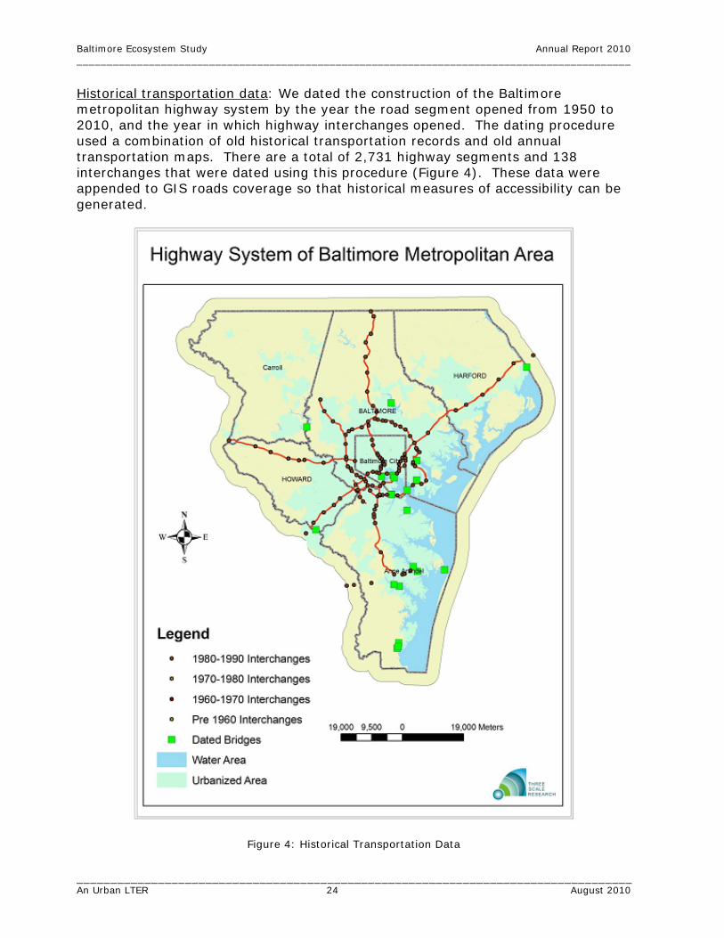
Historical transportation data: We dated the construction of the Baltimore metropolitan highway system by the year the road segment opened from 1950 to 2010, and the year in which highway interchanges opened. The dating procedure used a combination of old historical transportation records and old annual transportation maps. There are a total of 2,731 highway segments and 138 interchanges that were dated using this procedure (Figure 4). These data were appended to GIS roads coverage so that historical measures of accessibility can be generated.
Figure 4: Historical Transportation Data

Baltimore Ecosystem Study Annual Report 2010 ____________________________________________________________________________________________
__________________________________________________________________________________ An Urban LTER 25 August 2010
Conservation land use data for Carroll County: In addition to the subdivision data, we also constructed the historical data on land preservation. These data were available from Carroll County in spreadsheet format – it was then just a matter of matching parcel numbers and addresses. As of 2007 the county had around 950 parcels of land preserved on a total 54,000 acres (out of 289,000 for the entire county). Figure 5 shows the various land uses for the county as of 2007 based on the residential subdivision, agricultural land preservation and other land use data.
Figure 5: 2007 Carroll County Land Use
(Legend: major = major subdivision with 4 or more lots; minor = minor subdivision with 2-3 lots; other residential = non-platted residential parcels)
Historical housing price data for Maryland: Through BES contacts and collaborators at state agencies, we obtained annual housing price transaction data from the Maryland Department of Planning’s database for 1996-2009. These data will be used to construct local house price indices to model changes in price trends and volatility. 12. Spatial Data Analysis. The evolution of residential subdivision patterns: We analyzed the historical land use dataset that we developed for Carroll County to examine space-time dynamics in the pattern of developed land from 1960 to 2005. We measured the localized patterns of development relative to each individual subdivision as it appears on the landscape over time, which quantifies the local pattern of land use relative to each subdivision when it was developed. Because the spatial decision making unit is the subdivision, our descriptive analysis corresponds directly with a behavioral model of residential subdivision development. We define the proportion of developed land

Baltimore Ecosystem Study Annual Report 2010 ____________________________________________________________________________________________
__________________________________________________________________________________ An Urban LTER 26 August 2010
within a local buffer surrounding each of the individual subdivisions as: p(i,j,k,t) = a(i, j, k, t)/A(i, k, t), where a(i,j,k,t) is the total area of land in land use j, surrounding subdivision i, at a distance k from the subdivision border, in period t and A(i,k,t) is the total area of developable land in the buffer surrounding subdivision i, in period t. Using a script in ARCGIS we created varying distance buffers (100, 200, 400 and 800 meters) around each subdivision in each 5-year interval from 1960 to 2005. We broke land out into nine different land use categories including subdivision development, other residential, commercial, industrial and two different categories of undeveloped land (undeveloped and undevelopable). By evaluating this metric at a local subdivision scale and plotting as a function of time, this measure provides information on the pattern of developed land as it relates to the repelling versus agglomerative effects of subdivisions. The proportion of developed land measures local development density for each subdivision and reveals something about the location of development at a disaggregate scale. In addition, by controlling for undevelopable land we are able to remove large, protected parcels from consideration in determining the true aggregate fragmentation measure as it relates to future development. Results are discussed below. Measuring leapfrog development: Leapfrog development refers to a pattern of vacant land that is skipped over while land farther from the city center is developed first. Analysis of the historical land use dataset for Carroll County, permitted us to generate a measure of leapfrog establishment for each residential subdivision at the time of its development from 1960-2005. We measure the relative amount of leapfrog development that is associated with each subdivision event as follows: First, we create historical land use maps for each five-year period and identify the subdivisions that existed at that time period. The road segment that connects each subdivision to the city edge is identified and a local buffer is drawn around this. Then this buffer is intersected with the historical land use map to identify the relative amount of land that is undeveloped, but developable and that is located within this buffer. Because this land is located closer to the city center and could be developed, but was not at the time the subdivision was developed, this is a measure of leapfrog development that is created by that subdivision. After a subdivision is created, we apply this measure to each subsequent land use map to generate a time series of leapfrog development for each subdivision. This allows us to study the persistence of leapfrog development for each subdivision and across space. 13. Econometric Modeling of Land Development. Competing risks duration model for Carroll County: Using the historical subdivision and historical land preservation data for Carroll County, we has estimated a competing risks duration model of multiple land conversion options for undeveloped land. These options are a major subdivision (four or more buildable lots), minor subdivision (less than three buildable lots) or agricultural land preservation. Using these data from 1993-2007, the competing effect of these different conversion events is estimated to examine how each of these events interact with one another to explain the observed land use patterns for the county over the fifteen year period. The model is effectively a dynamic probability framework that accounts for the effect of various factors (soil type, distance to the city, surrounding land uses,

Baltimore Ecosystem Study Annual Report 2010 ____________________________________________________________________________________________
__________________________________________________________________________________ An Urban LTER 27 August 2010
etc.) on the likelihood of each of the three separate competing events occurring. The objective of the model is to uncover which factors affect the decisions between the three types of events and whether these events compete or interact with one another. The most important factors affecting the decision to pick one type over the other are assumed to be surrounding land uses in the previous periods, distance to large metro areas, lot sizes, soil quality, slope, and access to road networks. Preliminary findings are discussed below. Two other models are currently under development also using the Carroll County data. o A real options model of land conversion: The price data is used to construct a
localized quality-adjusted price index, which is then used in a common time series model to get estimates for historical house price drift and volatility. These local values are then used in a duration model where subdivisions are divided into three separate size groups and each is interacted with a continuous measure of distance to the two major central business locations (Baltimore and Washington, DC). Our focus is on determining if theoretical predictions for the development size and distance hold in all areas of an exurban county and, if not, what factors explain this effect.
o A Geographically-weighted Regression (GWR) model of land conversion:
Descriptive analysis of land conversion and preservation for Carroll County suggest a clear change in the likelihood of preservation versus large-scale development as one moves further away from the central business districts. However, “global” models only provide county-wide average parameter estimates for the decisions to develop versus preserve. It is clear from descriptive analysis that there is spatial heterogeneity in the explanatory factors affecting these two decisions. Using a multinomial discrete choice model and the GWR framework, which returns individual measures of the coefficients, these values will be mapped using GIS and uncover the spatial heterogeneity in the factors affecting development and preservation.
14. Agent-based Modeling. A dynamic monocentric model of household location and residential land development: We developed an agent-based model of household location demand and landowner development decisions to investigate urban land markets and spatial patterns when competition among households for residential location is spatially constrained, leading to potential differences in short and long run equilibrium rents across space. Our starting point is Capozza and Helsley’s (1990) model of a growing monocentric city with stochastic income growth. While the basic framework is the same, our model differs in several ways: (1) households are heterogeneous in income, (2) population growth in the region is determined by utility differences between the region and the rest of the world and, (3) household bids for location are not assumed to instantaneously adjust to a long run spatial equilibrium. Instead, households in our model formulate bids by anticipating the total number of households that are bidding for a particular location which determines their expected level of competition. When the number of anticipated bidders is not large, arbitrage is possible and households can maximize utility by retaining some amount of residual income which leads to land rents that differ from

Baltimore Ecosystem Study Annual Report 2010 ____________________________________________________________________________________________
__________________________________________________________________________________ An Urban LTER 28 August 2010
the spatial equilibrium. The model is specified using parameters based on estimates from the literature and simulated over time on a two dimensional grid using Netlogo software. 15. New Research Funding Relevant to BES. Collaborative Research, WSC-Category 2: Regional Climate Variability and Patterns of Urban Development – Impacts on the Urban Water Cycle and Nutrient Export. PI: Claire Welty; Co-PIs and Senior Researchers: Ed Doheny, Arthur Gold, Peter Groffman, Morgan Grove, Elena Irwin, Allen Klaiber, Sujay Kaushal, Michael McGuire, Andrew Miller, James Smith, Charles Towe, Elie Bou-Zeid. Dates: 1/1/2011–12/31/2015. Sponsor: NSF. Funding: $5,000,000. Description: This project will integrate theories and models across the disciplines of hydrologic science, environmental engineering, biogeochemistry, and economics to evaluate the interactions between urban development patterns and the hydrologic cycle and its associated nutrient cycles within the context of regional and local climate variability. Core elements include spatial modeling of urban development patterns and individual land use and location processes at parcel and neighborhood scales and for different policy scenarios; three-dimensional modeling of coupled surface water-groundwater and land surface-atmospheric systems at multiple scales (including consideration of the engineered water system), where development patterns are incorporated as input; and field work and modeling aimed at quantifying flow paths and fluxes of water and nutrients in this system. We will use the Baltimore Ecosystem Study LTER as a platform for place-based research to carry out the proposed work. Ongoing Major Activities Addressing Question 2: What are the fluxes of energy, matter, capital, and population in urban systems, and how do they change over the long term? To answer Question 2, we are conducting the following major research activities: • Document human demographic and social processes. • Quantify stream flow, chemistry, and key biota. • Measure extreme storm water flows and flooding. • Measure vegetation processes and nitrogen flux in riparian zones. • Measure biogeochemical pools and fluxes in contrasting upland patch types. • Quantify meteorological exchanges between surface and atmosphere using flux
tower technology. • Model atmospheric, hydrological and socio-economic fluxes in and across
contrasting watersheds. The research aimed at answering Question 2 takes into account the spatial structure of the Baltimore ecosystem, seeks feedbacks between socio-economic and biogeophysical processes, and has established sites in which long-term status and changes in fluxes are being measured. Integrated models, which incorporate ecological, hydrological, built, human and social capital, are key tools for understanding processes of flux and projecting changes into the future.

Baltimore Ecosystem Study Annual Report 2010 ____________________________________________________________________________________________
__________________________________________________________________________________ An Urban LTER 29 August 2010
New and Continuing Activities Addressing Question 2: 1. Stream Gaging. Since 1998, the US Geological Survey (USGS) has operated six stream gaging stations using full or partial NSF funding that provides part of the base infrastructure for physical investigations by the Baltimore Ecosystem Study. In addition, USGS operates five full-service stream gages in the Gwynns Falls watershed, and thirty other stations in the Baltimore region through funding from USGS and local cooperators. All discharge data are published each year in the USGS Annual Water-Data Report. USGS also initiated an analysis of flood frequency along the Gwynns Falls main stem using published discharge data from the four active stream gages on Gwynns Falls. Under a separate NSF grant that is focused on investigation of the urban water cycle, USGS has operated and maintained continuous-stage recorders at five small urban, sub-watersheds of Dead Run, which is a tributary to the Gwynns Falls. USGS also continues to collaborate with the U.S. Environmental Protection Agency and Montgomery County, MD to investigate impacts of urbanization on stream ecology in the Clarksburg Special Protection Area in Montgomery County, Maryland. 2. Urban Breeding Habitats – Mosquito Species. We began a pilot study to test the hypothesis that urban breeding habitats support fewer mosquito species but greater abundances of vector species that bite humans and may carry disease. All mosquitoes require water to breed. Temporary pools of standing water near stream banks were sampled monthly from sites surrounded by urban (paved) and rural (forested) landscapes within the BES domain. 3. Ecology of Invasive Species. The focus of this research is earthworm-soil fungi-tree three-way interactions. We are testing several hypotheses about how non-native earthworms might alter soil microbial communities and thus plant growth. In 2009-2010 year we continued collecting data on earthworm community composition from experimental plots with different leaf litter treatment. We have also been collecting biweekly data on soil respiration on earthworm exclusion and inclusion plots. In July 2010 we harvested the experiments. Part of the soil samples were archived for further analysis. The mesofauna extraction, measurements on root fungal colonization, and on N mineralization are ongoing. 4. Resampling the BES Permanent Plots. Co-PI Szlavecz and her lab members helped Cary REU student Russell Auwae to collect and process earthworm samples at the BES permanent forest plots. 5. Cub Hill Eddy Flux Tower. Research examines response of urban forest carbon dynamics under anthropogenic disturbance, land use change, elevated levels of green house gases and heat island effects (CO2, ozone and temperature).

Baltimore Ecosystem Study Annual Report 2010 ____________________________________________________________________________________________
__________________________________________________________________________________ An Urban LTER 30 August 2010
• Re-measurement of 2005 UFORE/iTree plots around the Cub Hill tower for validation of carbon uptake around tower was done in summer 2010.
• Ameriflux urban to rural tower site comparisons between NJ and Baltimore: We are conducting data reduction and comparison along urban to rural gradient. We collaborate with colleagues in Orlando and Syracuse on urban land use flux towers.
• Implementation of urban to rural tree/grass species plantings for growth, isotope and bioassay study with the University of Pittsburgh at Maryland Science Center (Cub Hill, SLEF and University of Pittsburgh).
• Obtained a new building at Cub Hill from the Maryland Department of Natural Resources Forest Service for expansion to urban air pollution and ICP Level 2 monitoring.
6. Wireless Sensor Networks (WSN) for Soil Monitoring. The WSN system is operation at Cub Hill. We have expanded our Cub Hill deployment: currently we have 53 motes operating in forest and grass sites. Post-doctoral fellow Yulia Savva is currently analyzing the massive dataset to reveal spatiotemporal patterns at various land use-land cover types at Cub Hill. 7. Soil CO2 Efflux Measurements. Graduate student Lijun Xia compared the more traditional chamber method to the continuous gas well method in the lab as well as in the field. These measurements are now complete and she has been analyzing the field data. 8. Investigating Urban Biodiversity: The Metacommunity Approach. Co-PI Szlavecz collaborated with Chris Swan, Tara Willey, and Steward Pickett to develop a new conceptual model to approach urban biodiversity studies. Since basic ecological theory cannot completely explain patterns in biodiversity in urban ecosystems, we suggest that true integration of an ecological and socioeconomic perspective is necessary. The new conceptual model of urban community ecology includes specific, testable hypotheses that will aid in understanding the general mechanisms by which species assemble in urban places, thus explaining patterns in alpha, beta and gamma diversity. 9. Factors Regulating Net Methane Flux in Urban Forests and
Grasslands. Methane is a potent greenhouse gas consumed through a biological oxidation process in soils. During urban and suburban land use change, native ecosystems are shifted to impervious surfaces, urban forests, and grasslands (lawns). These changes can influence CH4 uptake through alterations in physical, chemical and biological soil conditions. Long-term BES monitoring has found high net CH4 uptake in rural forests, lower net uptake in urban forests and complete inhibition of uptake in urban lawns. (Groffman et al. 2006, Groffman and Pouyat 2009) Here, we investigated four factors that could be causing this inhibition; reduced diffusion of methane into soils, production of methane in anaerobic microsites, inhibition of uptake by nitrogen additions from fertilizer or atmospheric deposition, and the presence of an unknown inhibitor in urban soils. Triplicate Soil samples were collected from four rural forest plots, four urban forest plots, and four urban grassland plots (36 samples total). Methane consumption rates were measured

Baltimore Ecosystem Study Annual Report 2010 ____________________________________________________________________________________________
__________________________________________________________________________________ An Urban LTER 31 August 2010
under ambient atmospheric and 10 ppm CH4 levels, with and without additions of 5 mg N/kg as NH4SO4. CH4 production rates were measured under anaerobic conditions. 10. Isotopic Tools Studying Atmospheric Pollutants Along Highway
Road Gradients. This research explores the use of isotopic tools to examine the deposition and sequestration of key atmospheric pollutants, CO2 and NOx, by vegetation. As part of this research, an inter-city comparison between pollution gradients in Baltimore and Pittsburgh was completed, and a study of a highway road deposition gradient was completed. This research will be the first to document the isotopic signature of vehicle emissions (NOx) in the US, and moreover one of the only to assess the impact of these emissions to ecosystems along urban to rural gradients. This is a key concern to the scientists and water quality managers in urban systems, biogeochemists, the stable isotope community, as well as air quality modelers. 11. Effects of Pharmaceuticals and Personal Care Products on Stream
Ecosystems. Co-PI Emma Rosi-Marshall is a recent addition to the BES team. She has been selecting study sites for research in examining the effects of pharmaceuticals and personal care products on stream ecosystems in the Baltimore area. This work to begin in the Fall of 2010 is funded by an LTER supplemental award. 12. Remote Sensing of Vegetation using 3-D Ecosynth. Co-PI Erle Ellis has worked with Grad Student Jonathan Dandois and on remote sensing of vegetation using computer vision for mapping wildland urban interface vegetation and structure. REU Student Evan Roberts has helped develop and test the new 3D vegetation scanning system. 13. Organic Matter. Co-PI Ken Belt is working on a series of papers using synthesized information from the literature and from data collected on baseflow and storm runoff in LTER streams. The data include information on fine particulate organic matter (FPOM) various particulate organic matter types and fractions, coarse particulate organic matter (CPOM), dissolved organic carbon (DOC), C, and N. All data are being analyzed in a hydrologic context and are being integrated with unit value and daily value USGS flow data. Co-authors will include BES Co-PI’s R. Pouyat, C. Swan, A. Miller, C. Welty, S. Kaushal, P. Groffman, and others. Below are tentative titles and descriptions of the work. Urban Drainage Networks: the Gutter Subsidy the “Urban Karst” effect and the Urban Engineered Stream Continuum (UESC). This is a concept-data paper to put into perspective the complete hydrological picture of how organic matter and coincidentally, other constituents, moves to streams from locations in the landscape distant from the traditional riparian patches. It will use synthesized literature and data from BES and Baltimore City Department of Public Works (DPW) sampling programs. It will include results of a leaf load model focusing on three of the LTER stream catchments that examines the expected leaf fall into and near gutters and small urban streams. Elements will include: The urban landscape and its streams;

Baltimore Ecosystem Study Annual Report 2010 ____________________________________________________________________________________________
__________________________________________________________________________________ An Urban LTER 32 August 2010
Connectivity of Urban drainage networks, streams and groundwater; the gutter subsidy, leaf load estimates (CPOM) from stream samples, remotely sensed ISC data; and the Urban Engineered Stream Continuum (UESC). Stream Litter Breakdown along an Urban-Rural Land Use Gradient. This work examines stream leaf litter breakdown rates: riparian/upland and urban/rural. In-situ leaf litter breakdown rates were measured during Winter-Spring of 2005 in an urban (Gwynns Falls at Gwynnbrook) and a forested (Baisman Run) stream, using Sycamore (riparian) and Planetree (the hybrid "urban" counterpart) leaf litter. The paper also compares Sycamore tree litter breakdown from along the urban rural gradient. Elements will include: Sycamore vs. Planetree breakdown rates in urban and rural streams; Sycamore breakdown rates along an urban-rural gradient; gutter effects of Planetree breakdown; leaf moisture characteristics of urban vs. suburban Planetree litter; and leaf loads in the urban landscape. Fine Particulate (FPOM) and Dissolved Organic Matter (DOC): Concentrations, Size Fractions and Fluxes in the urban landscape. This work draws on grab and focused sampling that included total suspended solids (TSS) and FPOM (=VSS) from the thirteen BES stream networks covering an urbanization gradients, over years 2005-2007, and covers a variety of hydrologic contexts, even though focused storm sampling is not included. The TSS and FPOM data can be parsed by size fraction 0.7 μm, 250 μm, 500 μm and 1mm and this will be done for all analyses. A useful derived variable will be percent organic matter (i.e. FPOM/TSS), since this relates to the "food" quality of seston. The paper will examine various contexts and drivers for FPOM and DOC concentrations and fluxes, land use, season, drainage network density and baseflow hydrologic interactions, put these into an ecological context and discuss them in terms of the urban engineered stream continuum (UESC). Fine Particulate (FPOM) and Dissolved Organic Matter (DOC): Stormwater Concentrations, Size Fractions and Fluxes in the urban landscape. This work draws on the focused stormwater hydrograph sampling using automated ISCO instruments from three intensive sites (Dead Run, Baisman Run, Gwynns Falls at Gwynnbrook), and also Gwynns Falls at Villa Nova, for the Fall of 2007. The same constituent parameters were done as above, but without fractioning into size classes. The bulk of the DOC samples have not been analyzed due to budget cutbacks. The paper will also examine various contexts and drivers for FPOM and DOC concentration at fluxes, land use, season, drainage network density and Baseflow Hydrologic Interactions. These will be put into an ecological context and discussed in terms of the urban engineered stream continuum (UESC). It will, however, focus on smaller time scales and examine stormwater runoff dynamics in terms of flow rate and hydrograph position; baseflow and seasonal hydrologic interactions; and potential effects on annual loads. 14. Pathogens: E. coli. Co-PI Ken Belt is working on two papers utilizing data already collected. (1) with co-author K. Readel: Long-term E. coli stream concentrations and fluxes in the urban landscape: small headwater streams and storm drains. This work draws from sampling in BES-Forest Service (FS) streams for E. coli continued until May 2008 (when FS budget constraints forced cessation). These data are currently

Baltimore Ecosystem Study Annual Report 2010 ____________________________________________________________________________________________
__________________________________________________________________________________ An Urban LTER 33 August 2010
being reviewed and analyzed in the context of the temperature data collected by FS, the flow data collected by USGS and ancillary nutrient and cation data produced by the Cary Institute of Ecosystem Studies. The final analysis of this data (affecting QC process, programming) has been delayed due to budget and personnel cutbacks. (2) with J. Higgins: In-situ survival of Escherichia coli in stream water. Work is also still under way for an E. coli survival paper which will describe the long periods E. coli 0157 can survive in urban stream waters. These data need further statistical analysis due to data design change mid-way through the collection process. 15. Stream Temperature. Co-PIs Ken Belt and Gordon Heisler are preparing a paper: Long-term E. coli stream temperatures and thermal fluxes in the urban landscape: small headwater streams and storm drains. These almost continuous measurements of stream temperature in ca twenty BES-FS streams have continued (but with about half the stations being dropped in May 2008 due to FS budget cutbacks.) These data are currently being reviewed and will be analyzed in the context of the flow data collected by USGS and ancillary nutrient and cation data produced by the Cary Institute. The paper will examine various contexts and drivers for temperatures and fluxes, land use, season and drainage network density, and baseflow hydrologic interactions. The data will be put into an ecological context and discussed in terms of the urban engineered stream continuum (UESC). It will, however, also focus on smaller time scales and examine stormwater runoff dynamics in terms of flow rate and hydrograph position; baseflow and seasonal hydrologic interactions; and potential effects on annual loads. The final analysis of this data (affecting QC process, programming) has been delayed due to budget and personnel cutbacks. 16. Climate Change. Co-PI Ken Belt is involved in several efforts to establish stream site networks for monitoring climate change. Belt acts as a BES LTER representative on these efforts which include: (1) a Maryland effort by the Maryland Water Monitoring Council (MWMC), (2) USGS climate change monitoring, and (3) the USDA Forest Service experimental forest and ranges network. The MWMC Monitoring and Assessment committee is conducting a workshop in September to initiate the establishment of a network of stream sites (from existing resources) to detect climate change in Maryland streams (and possibly other states). Belt is also communicating with the USGS folks in conjunction with their efforts establish a national network led by Peter Murdock, and hopefully, to name the Chesapeake Bay watershed, as a CORE site. Belt has been pushing the idea of including urban, and of course the BES sites, in these networks. Belt will also be exploring the feasibility of integrating the USFS experimental forests and range networks into these processes so that long-term data sets can be used in conjunction with any Maryland data collection and as sites for various kinds of experimental stream work in cross-site comparisons. Hopefully these contacts and contexts can be used to revive our long-term FS stream temperature and related work (E. coli, litter processing, denitrification, etc.) in grant proposals. In particular the stream temperature data has potential for supporting in-stream biogeochemical process work and in quantifying the effects of trees in both upland and riparian on temperature regimes in streams and shallow groundwater. One of the things Belt hopes to push with the Maryland network is

Baltimore Ecosystem Study Annual Report 2010 ____________________________________________________________________________________________
__________________________________________________________________________________ An Urban LTER 34 August 2010
the idea of getting beyond the "typical" parameters and add in-stream process and function to any effort to do long-term monitoring regarding climate change effects on streams (e.g. denitrification, litter breakdown). 16. Watershed 263, Ultra Urban Headwater Catchments. This work, done in partnership with Baltimore City Department of Public Works, continues with the objective of measuring change in runoff quantity and quality as the watershed restoration activities increase in the catchment. Monitoring at the two small urban headwater catchments continues (with continuing equipment problems) and data is being analyzed to produce a paper which discusses the water quality characteristics of these two ultra urban sites and how they are being used to place into context old, highly impervious sites such as these in terms of other urban and suburban sites and in terms of management issues. Budget cutbacks in both the FS and DPW have severely decreased already thin resources for monitoring in these two storm drains. In particular the repeated damage by surcharging pipe flows to the ISCO samplers has necessitated that these be withdrawn from the field because too few personnel were available to be ever-ready to remove them in the event of high flows. This has temporarily ended storm composite sampling. The sites also suffer from inadequate flow ratings, again due to limited personnel availability and primary devices (flumes). It is hoped that these sites can be included in a grant proposal to allow these activities to resume. A US Forest Service general technical report and a data paper are being planned that will serve as a summary of the methods and hydrology research so far in this catchment. In the meantime the data will be used for various purposes such as for the urban stream work mentioned above and for modeling purposes. We are also looking for resources to resume application of the SWMM Model. 17. Measuring and Modeling Urban Temperature Patterns. BES climate scientists are measuring and modeling the pattern of urban temperatures in Baltimore and surrounding areas. 18. Urban Water Cycle. Research has been conducted on the urban water cycle, including comparisons of watershed hydrologic response associated with varying patterns of urban development and stormwater management; geomorphology and hydraulics of the urban riparian zone, and the influence of urban infrastructure on flow patterns and residence times in urban streams. 19. Stormwater Pond Food Webs. Research by Ph.D. student Robin Van Meter and Co-PI Chris Swan studying pond food webs and the effect of road deicer/road salt on life in the ponds is finishing. 20. Research on Pond Branch Hydrology and Biogeochemistry. Work has continued on the hydrologic controls of nitrogen biogeochemistry. Specifically, we are interested in what causes stream nitrate concentrations to peak in summer. While there are many mechanisms that could potentially contribute to this behavior, we are focusing on those that are hydrologic in nature. Research has focused on Pond Branch, the forested reference watershed and has combined field work and distributed hydroecological modeling.

Baltimore Ecosystem Study Annual Report 2010 ____________________________________________________________________________________________
__________________________________________________________________________________ An Urban LTER 35 August 2010
Riparian Transects: We have instrumented two transects across the valley bottom with wells with capacitance-based water level probes. While the general patterns reveal interesting diurnal patterns, the precise values have been offset from observed on several field visits. Each well has been recalibrated and one has been replaced with a new unit. Four of the eight wells have also been instrumented with a pressure transducer to more accurately determine water tables. Preliminary results suggest that diurnal variability is exhibited in each well, but the amplitudes are higher in the headwaters than the downstream locations. This may have importance for the spatial patterns of nitrogen processing and transport which we intend to explore in the coming year. At these transects we are interested in measuring controls of denitrification, namely soil moisture and soil oxygen. Soil cores are also being collected seasonally. Water Quality Sampling: Beginning in late May, longitudinal stream sampling has been conducted to address two questions: (1) Are there changes in form of nitrogen from upstream to outlet? (2) Where along the stream does nitrogen enter? If we know the spatial location of nitrogen input, we could better quantify the mechanisms accounting for the seasonal shift. Is there a shift in flowpaths to groundwater in summer that could account for the difference? Sampling springs and riparian wells would give us the ability to quantify groundwater chemistry. Sampling locations include six stream locations, two groundwater springs, and four groundwater wells. Stream sampling sites are located: near the headcut at the inception of the stream, at the upper transect of wells, above the gasline cut, below the gasline cut, at the lower transect of wells, and at the watershed outlet. Soil Moisture: Better defining the biogeochemically active portions of variable source areas is a major research challenge. Expansion and contraction of variable source areas on seasonal and event timescales could determine whether certain areas contribute or dilute nitrate concentrations. To examine the spatial extent of variable source areas, we have established transects for soil moisture measurements in representative portions of riparian microtopographies and different types of hillslopes (narrow incised hollows, broad gradually sloping hollows, and steep planar slopes). The initial survey was just conducted and at least monthly samples will continue over the next year. 21. Lawn Management and Suburban Watershed Modeling. Analysis of lawn fertilizer use emphasized determinants of fertilizer applications to residential lawns and incorporation of results into watershed models. Limited predictive capabilities for the amount of fertilization applied based on parcel and lawn size and parcel tax value provides the ability to condition a stochastic model of N addition. Development of a watershed model incorporating impervious surface, lawn, forest and other covers includes run-on infiltration in a set of the suburban catchments and demonstrates the marginal reduction of stormwater runoff based on conversion of lawns to wooded areas. Ongoing work will quantify the change in N cycling components as a result both of land cover conversion and different lawn management scenarios. Two papers have been submitted on this topic with another manuscript in development.

Baltimore Ecosystem Study Annual Report 2010 ____________________________________________________________________________________________
__________________________________________________________________________________ An Urban LTER 36 August 2010
22. Analysis of BES and Mid-Atlantic Watershed N Export. Time series analysis of catchment discharge and nitrogen concentration and loads for eight BES sites and four mid-Atlantic (non-BES) sites were carried out with the USGS Fluxmaster regression package. There appears to be a flush of nitrate into streamwater in less developed catchments where groundwater storage and transport are important. This indicates that the major loading on N into the Chesapeake Bay when wet conditions follow dry conditions may be weighted to agricultural and low density suburban catchments, and that there is as much as a one year memory effect to N export based on the groundwater flushing time. A masters thesis was completed this summer by grad student Katerina Savvas and will be submitted for publication. 23. Sediment Core Studies—Chesapeake Tributaries—N Cycling. Co-PI Grace Brush supervised grad student and IGERT Erin Tush in collecting and analyzing sediment cores in Chesapeake tributaries in order to understand nitrogen cycling under different kinds of land use and to compare the results from sediment cores with nitrogen cycling in storm water management ponds. Undergraduate student Hannah Band assisted Erin in collection and preparation of cores and conducted pollen analyses of the cores. 24. Invasive Ragweed Studies. Guided by Co-PI Grace Brush grad student Michael Martin collected extant ragweed populations from all over eastern US and Canada and also herbarium specimens from the US to characterize the genetics of ragweed populations. He will compare populations 100 to 150 years old with extant populations in order to determine whether the huge invasive success of ragweed is related to cross pollination and increased genetic diversity following deforestation and land clearance. He will follow this up by investigating the genetics of pollen grains from sediment cores. 25. Isotope Analysis of Plant Material. Grad student Jin Tao, working with Co-PI Grace Brush is setting up a protocol for collecting plant sample material and collecting material for isotope analysis from plants that occur on different geologic substrates. The goal of this study is to compile an “isotope” landscape of the BES and surrounding area to determine the sources of nutrients. 26. Development of Rating Curves for a Network of Stream Gages. The study watersheds with gages presently collecting stage data encompass a range of development histories and land-cover patterns as well as some variation in geologic controls. These gages have the capacity to provide critical information about watershed hydrologic response over a range of spatial scales and development patterns if we can support reliable rating curves or stage-discharge relationships. It is often difficult or impossible to collect direct discharge measurements at high flows, most of which are generated by summer thunderstorms, both because of the dangerous conditions in the channel and also because the stream rises and falls so rapidly that field crews cannot reach the sites in time and cannot make measurements rapidly enough to keep pace with changing water levels even when they are on site during the storm. Modeling efforts are devised to fill this gap.

Baltimore Ecosystem Study Annual Report 2010 ____________________________________________________________________________________________
__________________________________________________________________________________ An Urban LTER 37 August 2010
Current efforts involve the use of 2d hydraulic models to simulate flow patterns and water levels associated with recorded stages during high-flow events. We are currently using TUFLOW, a depth-averaged 2d finite-difference model with simulation of the hydraulics of urban infrastructure. In order to generate working models we utilize high-resolution LiDAR data available for each gage site and supplement the LiDAR topography with field survey data collected using a total station to characterize the channel bed and the water surface at base flow (Figures 6,7).
Figure 6. Shaded relief contour map showing merged LiDAR and field-surveyed topography for the Dead Run tributary at the DR-5 gage site. The line running down the channel center line was used to extract model results for comparison with surveyed water levels along the longitudinal profile of the channel.

Baltimore Ecosystem Study Annual Report 2010 ____________________________________________________________________________________________
__________________________________________________________________________________ An Urban LTER 38 August 2010
Figure 7. Shaded relief perspective view of the Red Run channel, floodplain, adjacent raised parking lot and road embankment, based on merged LiDAR and field-surveyed topography at the Painters Mill Road gage. Bridge deck is not shown but the vertical bridge pier along the left bank of the channel is included in the model.
The merged topographic data sets are used as input, along with resistance coefficients representing the spatial variability of surface roughness, in order to drive the 2d model. We collect longitudinal profiles of the water surface over a range of stages, including stages from base flow to stages near or above bankfull, and match the surveyed profiles to simulated water-surface profiles generated by the model. The set of stage-discharge data points generated using the model for lower flows are compared with data generated by direct discharge measurement within that same range of flows in order to determine whether the model is consistent with the portion of the rating curve determined from direct measurement. We then find the discharge that best matches each of the longitudinal water-surface profiles surveyed for higher flows. This allows us to develop a provisional rating curve for the gage. We test the provisional rating curve by using it to develop an input discharge hydrograph based on the recorded stage hydrograph for a known storm associated with flooding at the stream gage. If the resulting model run provides a strong match to the original stage record as well as the surveyed longitudinal profile, the rating curve is considered successful. This in turn allows us to convert our stage records to discharge records and to assess the differences in watershed response among our network of gages. 26. Analysis of the Effects of Urban Infrastructure on Longitudinal
Profiles, Residence Time and Flow Paths. The geomorphic template for urban streams and riparian zones is heavily influenced both by upstream modification of the land surface, leading to alterations in watershed hydrologic response, and by direct modification of the riparian zone itself through channel straightening, construction of road embankments, construction of gabions or other protective structures, and earth-moving operations modifying

Baltimore Ecosystem Study Annual Report 2010 ____________________________________________________________________________________________
__________________________________________________________________________________ An Urban LTER 39 August 2010
floodplain topography. One of our research goals is to characterize the relationship between morphology and flow patterns in urban riparian zones and to determine whether there are characteristic patterns that can be tied to the type of development and infrastructure in the watershed. To date we have conducted extensive longitudinal surveys of the channel thalweg along one highly urbanized channel (Dead Run at Woodlawn, the reach including the DR4 site; Figure 8), one suburban channel in a watershed developed more recently with less direct modification of the valley floor (Red Run at Painters Mill Road; Figure 9), and one channel in a suburban watershed within a protected forest reserve that has no bridges or road crossings (Horsehead Branch at McDonogh; Figure 10). Additional surveys are planned for Fall 2010, with the goal of developing a more complete analysis of controls on longitudinal profile and residence time in channels representing a range of development patterns.
Figure 8. Dead Run water-surface profiles.

Baltimore Ecosystem Study Annual Report 2010 ____________________________________________________________________________________________
__________________________________________________________________________________ An Urban LTER 40 August 2010
Figure 9. Red Run water surface profiles.
Figure 10. Horsehead Branch water-surface profiles.

Baltimore Ecosystem Study Annual Report 2010 ____________________________________________________________________________________________
__________________________________________________________________________________ An Urban LTER 41 August 2010
Ongoing Major Activities Addressing Question 3: How can people develop and use an understanding of the metropolis as an ecological system to improve the quality of their environment, and to reduce pollution loadings to downstream air- and watersheds? To answer Question 3, we conduct the following major education, interaction, and research activities: • Develop or participate in educational partnerships. • Analyze the ecological knowledge base and its use in different social contexts. • Interact with governmental agencies at various levels to exchange ecological
knowledge and information. • Interact with communities, community groups, and non-governmental
organizations to enhance ecological understanding. • Design social and educational assessments to determine the changing role of
ecological knowledge in Baltimore. • Manage information to enhance flow of data and knowledge within BES, and
between BES and agencies, communities, and individuals. • Participate in assessment of storm drain Watershed 263 restoration activities
and evaluation. • Provide internships for secondary, college, and graduate students, and
fellowships for teacher involvement in ecological research. • Focus studies in the Minebank Run stream restoration project.
In addressing Question 3, partnerships are crucial. Because this question deals with the flow of information and its use, our activities recognize the diversity of sources and users of ecological and other relevant information, and the need to maintain two-way flows of information and joint understanding of ecological issues. Of the three areas of activity in BES, this one is the most fluid and developmental, since it depends on evolving and expanding relationships in the Baltimore region as well as evolving and expanding ecological understanding. New and Continuing Activities Addressing Question 3: 1. Kidsgrow. We have continued to develop and provide curriculum and teacher professional development to the Parks & People Foundation KidsGrow After-School Program. In the 2009-2010 school year, KidsGrow was located at two sites; Franklin Square Elementary School and William Paca Elementary School. Approximately 130 students participated in the program at these two highly urbanized Baltimore City Public Schools. Five complete modules from the My City’s An Ecosystem! curriculum were taught during the school year, plus the students were engaged in field trips and with classroom visitors. The students took field trips to Port Discovery Children’s Museum, Cromwell Valley Farm, Great Kids Farm, and the White House. They also visited community gardens and participated in an environmental arts program twice a month. Students also participated in an overnight experience at Patapsco State Park and Echo Hill Outdoor Science Center. The fall semester was spent on a rich exploration of urban ecosystems and

Baltimore Ecosystem Study Annual Report 2010 ____________________________________________________________________________________________
__________________________________________________________________________________ An Urban LTER 42 August 2010
decomposition. Students developed an understanding of urban ecosystems by studying their schoolyard and neighborhood ecosystems and investigating the causes of decomposition. During the spring semester, students learned about water in the city, the ecological history of their communities and were engaged in the Ecology of Food, Agriculture and Nutrition module. During the latter module, students began to understand where our food comes from before it gets to the grocery or corner store. Students at both schools planted their own schoolyard vegetable gardens and held a Salad Extravaganza at the end of the school year. 2. Research Experience for Teachers (RET). With the support of the new NSF MSP grant for the Baltimore Partnership for Environmental Science Literacy, we were able to offer four teachers an intensive 6-week research experience during the summer of 2010. Each worked closely with a scientific mentor, developing and carrying out an independent research project. In some cases, the research will continue into the coming school year. The RET Fellows also participated in a 6-week summer graduate course at Towson University. Each Fellow will be participating in school year workshops and working closely with BES scientists and educators to develop and test teaching activities that build on their research experiences. The four Fellows spent six weeks during the summer of 2010 and completed their RET work in August. They are: Ralph Causarano: Mr. Causarano, a science teacher at Franklin Middle School, conducted research with mentor scientist, Dr. Andrew Miller (BES and University of Maryland, Baltimore County). His research focused on land use impacts on stream flow in the Dead Run subwatershed of the Gwynns Falls watershed. Kathy Kingsley: Ms. Kingsley, a science teacher at Owings Mills High School, conducted research with mentor scientist, Dan Dillon (BES and Cary Institute of Ecosystem Studies). Her research focused on stream chemistry data comparisons across multiple stream sites within the Gwynns Falls watershed. Evelyn Sharkey: Ms. Sharkey, a science teacher at Northwestern High School, conducted research with mentor scientist, Dr. Chris Swan (BES and UMBC). Her research focused on the impacts of increased salinity on leaf litter respiration. Kate McLean: Ms. McLean, a science teacher at General Stricker Middle School, conducted research with mentor scientist, Neil Bettez (BES and Cary Institute of Ecosystem Studies). Her research focused on nitrogen deposition along the urban to rural gradient of the Gwynns Falls watershed. 3. Towson University Summer Course. Investigating Urban Ecosystems: Research and Teaching Applications. In addition to conducting 6-week research projects, the four RET Fellows participated in a two credit graduate course called Investing Urban Ecosystems: Research and Teaching Applications. This graduate course, developed specifically for participants in the Baltimore Partnership for Environmental Science Literacy project, met twice weekly for six weeks beginning in late June 2010. The Tuesday session of each week focused on cutting edge science content from BES and related urban ecosystem research. The Thursday session of each week was presented by a science educator

Baltimore Ecosystem Study Annual Report 2010 ____________________________________________________________________________________________
__________________________________________________________________________________ An Urban LTER 43 August 2010
and included insights from research into teaching and learning about that week’s topic and included examples of effective pedagogy and instructional materials for use in middle and high school classrooms. The four RETs will continue to participate in the Baltimore Partnership by joining the teachers from the Summer Teachers’ Institute for five one-day professional development sessions to be held during the 2010-2011 school year. 4. Baltimore Ecosystem Study Teachers’ Institute. Seventeen teachers participated in a summer workshop that represents the first portion of a year-long Baltimore Ecosystem Study Teachers’ Institute. The workshop, an 8-day professional development program focusing on urban ecology and placed-based teaching methods, was designed specifically for participants in the Baltimore Partnership for Environmental Science Literacy funded by the National Science Foundation. These middle and high school science teachers received training in environmental science research and teaching techniques, and learned about the project’s education research into student thinking and learning. Three days overlapped with the Towson University Summer Course, “Investigating Urban Ecosystems: Research and Teaching Applications.” On those days, Institute participants joined the four Research Experiences for Teachers (RET) Fellows for afternoon lectures by BES scientists and Towson University professors. Overall teacher goals of the Summer Institute included: • Gaining deeper content knowledge about the key dimensions of environmental
science literacy. • Developing strong ecosystem thinking skills – the ability to apply systems
thinking, evidence-based (scientific) thinking, spatial and temporal thinking, quantitative reasoning, trans-disciplinary thinking, and creativity to understand any place as an ecosystem.
• Learning about patterns and challenges in student thinking and learning about environmental science in general, and urban ecosystems in particular.
• Learning about effective pedagogies and teaching resources. • Gaining an appreciation for the nature of environmental science and inquiry,
with specific reference to understanding urban ecosystems. • Viewing teaching and learning of environmental science in the context of
learning progressions. • Having increased confidence to teach about urban ecosystems. • Understanding the benefits and costs of various approaches to teaching
environmental science. These seventeen teachers along with the four RETs will continue to participate in this Partnership during the 2010-2011 school year by attending five one-day professional development sessions. The teachers will develop concrete plans for teaching about the Baltimore ecosystem in the upcoming school year, provide students the abilities to attain positive outcomes in terms of content knowledge, skills, citizenship practices and attitudes towards science and become part of a learning community of students, scientists, teachers, and education researchers in Baltimore and across the nation, that is interested in defining and fostering environmental science literacy.

Baltimore Ecosystem Study Annual Report 2010 ____________________________________________________________________________________________
__________________________________________________________________________________ An Urban LTER 44 August 2010
5. Communicating Climate Change (C3). In the fall of 2008, BES began a partnership with the Maryland Science Center and eleven other science centers around the country. This collaborative partnership, entitled, “Communicating Climate Change” (C3), is supported by an NSF Informal Science Education grant and uses current research and citizen participation to illustrate local signs of climate change. This year the C3 project in the Baltimore region used citizen scientists to gather local temperature data across an urban to rural gradient to illustrate the effects of the Urban Heat Island. BES scientists advised the science center in temperature collection methods. 6. Education Research: Investigations in Student Thinking and
Learning. BES is a partner in an NSF MSP-supported project that is developing a comprehensive framework for environmental science literacy. The project is a collaboration headed by John Moore (Colorado State University) at the Short Grass Steppe LTER Site, and includes Andy Anderson (Michigan State University) at the Kellogg Biological Station LTER site, Allison Whitmer (Georgetown University) at the Santa Barbara Coastal Ecosystem LTER site, and a number of other colleagues at colleges and universities across the nation. This project is allowing us to conduct significant, long-term and large scale (across sites) research about how students think and learn along key strands of an environmental literacy learning progression. Extensive research took place during this past year as part of the work of the Carbon, Water and Biodiversity Strands of the MSP project. Students and teachers completed “tests” to describe their thinking about key ideas in these subject areas, and student interviews were carried out to complement the written tests. This work continues in the current year. 7. Ecology Teaching Study. Plans are underway to repeat the study in order to begin describing long term trends in ecology teaching in the metropolis. 8. Watershed 263. Parks & People Foundation worked with federal, state, and local government and community-based organizations to develop and implement restoration plan for 900-acre storm drain watershed (Watershed 263). Eleven neighborhoods in Southwest Baltimore are demonstrating the impact of greening strategies on quality and quantity of storm water runoff and quality of life. PPF has also collaborated with the US Forest Service and Baltimore City DPW to collect baseline data for assessing impact of restoration activities. PPF continued to work with the Watershed 263 Stakeholder Council to develop indicators to monitor and evaluate outcomes of the large-scale watershed restoration project in collaboration with Eileen McGurty of Johns Hopkins University. 9. Building Resources and Nurturing Community Health &
Environmental Stewardship (BRANCHES). Parks & People implemented BRANCHES youth forestry training and summer employment program with Department of Recreation and Parks in four public parks in Baltimore and on two public housing sites. BRANCHES provides economically

Baltimore Ecosystem Study Annual Report 2010 ____________________________________________________________________________________________
__________________________________________________________________________________ An Urban LTER 45 August 2010
disadvantaged youth with training and employment experience to develop useful job skills that can lead to long-term opportunities in tree care related professions. PPF coordinated consultation between BES scientists and Department of Recreation and Parks staff to develop training for youth team supervisors. Funding was secured to extend the BRANCHES youth training forestry program for year-round afterschool employment for nine youth environmental education for 2009-2010 academic year and summer 2010. 10. Research and Community Engagement. Much of our community engagement is facilitated by BES key partner, Parks & People Foundation, Inc. They participated in the following additional projects on behalf of BES: • Initiated technology transfer and community outreach education organizing and
support for the Harris Creek Watershed (246), a joint project of the Baltimore City Department of Public Works, and the Baltimore Harbor Watershed Association.
• Strengthened relationship with Coppin State University, a member institution of the historically black colleges and universities systems. Maintained relationship and outreach to Baltimore City Community College to provide field experiences and professional development for their new formed Environmental Sciences major.
• Initiated a series of “Green Career Ladder Exploration Workshops” as part of the with the Mayor’s Office of Economic Development, Afterschool Matters II program at four Baltimore City Public High Schools. Parks & People, BES scientists and interns participated as facilitators.
• Provided environmental education enrichment for 750 Baltimore City 2nd and 3rd graders participating in the PPF SuperKids Camp 6-week reading enrichment summer program; and 60 Baltimore City Middle School Youth participating in Project BLUE (Baltimore Lessons in Urban Ecosystems) using curriculum jointly developed by Parks & People Foundation interns and USDA-Forest Service scientists.
• Organized and provided technical and logistical support to BES scientists, and graduate assistants working on tree canopy and community garden studies.
• Participant in TreeBaltimore initiative to increase tree planting in Baltimore to reach the City Urban Tree Canopy Goal.
11. Information Management. The BES website is an active online presence for this LTER. Updates and improvements are ongoing. Following are recent highlights and accomplishments: • BES website now has ten years of stream chemistry data available online. • Curricula and materials for the Math and Science Partnership are online on the
BES website. • The BES data access page is now completely dynamic, generated from a search
form that builds an SQL query based on the terms the user enters. The code allows the user to enter as many, or as few words as desired. Rather than using an "AND" logical approach, which would dictate that all words must be present, an "OR" linking is used so that records that match any of the words are displayed. This approach allows the user to freely add as many words as desired.

Baltimore Ecosystem Study Annual Report 2010 ____________________________________________________________________________________________
__________________________________________________________________________________ An Urban LTER 46 August 2010
• There are currently 529 datasets available on the BES website. • BES metadata is kept in 100% EML format. The data display page in a human
readable form on the website is generated from the EML, as is the information that is harvested by the LTER Metacat system.
• All data in the Spatial Analysis Lab directed by Co-PI Jarlath O’Neil-Dunne are available online on the BES website and the LTER Metacat. The corresponding metadata is also online and searchable.
• BES Publications online have been standardized to EndNote format. From this format they are imported into a database which is searchable on the BES website. The BES publication database is also available through the LTER Network Office portal via their harvesting system.
• We are now hosting a "Moodle" Learning Management System to deliver curricula online.
• Website developments currently underway include a Content Management System (Drupal) for the BES Intranet and an improved online tabbed metadata entry/edit form.
Information Manager Jonathan Walsh is a member of the LTERMaps project, ProjectDB and others. He is also member of the LTER Network GIS Committee and EML Best Practices Committee. Outreach Outreach is fundamental to the mission and success of the Baltimore Ecosystem Study. As a research question, we are concerned to know how people develop and use knowledge of the metropolitan area as an ecological system. In addition, we have learned from the literature and from a ten year social science and community restoration research program in Baltimore predating the LTER effort, that informing and working with communities and constituencies is required to conduct ecological research in the city and suburbs. Hence, we conduct a wide variety of community and educational activities. 1. BES Annual Meeting and Community Open House/Greening
Celebration. Formal public outreach is accomplished through the BES Annual Meeting, attended by scientists, educators, community members, and decision leaders from the Baltimore region as well as by BES researchers and educators. The evening Open House is held annually in conjunction with the Parks & People Foundation's Annual Greening Celebration. Parks & People has been instrumental in attracting Baltimore residents and local and federal government leaders to the Open House and Greening Celebration. Over time, the number of attendees at these functions has grown. Attendance at the Annual Meeting in 2009 was over 125 and there were approximately 200 attendees at the Greening Celebration. Parks & People Foundation presented awards to individuals and groups for their local community gardens. Additional Research Meetings held during the year focused on the upcoming BES renewal. These meetings included presentations and discussions on climate and environmental change, environmental justice, land use and land cover,

Baltimore Ecosystem Study Annual Report 2010 ____________________________________________________________________________________________
__________________________________________________________________________________ An Urban LTER 47 August 2010
sustainability and resilience, current and future challenges for cities and integrative modeling and sampling. 2. Educational Outreach. • Many of the educational items previously covered in this report can also be
considered outreach, as they brought urban ecology perspectives to important and often underserved audiences. Beyond our formal work with participating teachers and their students, and the KidsGrow after school program we engage in informal outreach on a regular basis, often in conjunction with Parks & People Foundation programs. During the current reporting period, the Education Coordinator participated in many Parks & People events, sometimes wearing a combined volunteer/BES education hat.
• Co-PI Shannon LaDeau provided data and expertise to the BES education team
to support curriculum development around phenology, climate change, and mosquitoes.
• Co-PI Kathy Szlavecz gave a lecture on Soil ecosystems in cities, at the
Teachers’ Workshop on Urban Soils (NSF funded Math Science Partnership) at Towson University on November 7, 2009. She has also students and the public on the issues of earthworm invasion.
• Developing user-friendly graphic interface (“see Grazor” at
www.lifeunderyourfeet.org/en/tools/). This interface allows the public (at any level of scientific interest) soil data collected with our wireless sensor network. Users can look at maps, time-series data, and calculate daily, monthly, etc. averages. They can download the data and use them for their own purposes.
• Co-PI Ken Belt gave a class lecture on the development of the organic matter
research questions and approaches to the Urban Experimental Design graduate Class at UMBC on October 4, 2009. He gave another class lecture on November 4, 2009 at UMBC on "Urban stream ecosystems: complexities, continuums and gutter subsidies," for the course, Water in the Urban Environment. Belt also gave a lecture for the REU Summer Program, “Urban stream continuums, organic matter and gutter subsidies: the complexities of engineered ‘urban karst,’” at Towson University, on July 20, 2010.
• Owings Mills High School Urban Ecology Course, Owings Mills, MD, April 13,
2010. The junior and senior classes of Owings Mills High School of the Baltimore County Public School system participated in a hands-on activity in conducting a soil quality assessment on the campus grounds of the school. Co-PI Dr. Quin Holifield, a soil scientist with the USDA Forest Service-NRS-8, was invited by Ms. Kathy Kingsley, an instructor in biology and environmental science, to conduct the day-long activity. The objectives of the activity were to conduct a soil quality assessment on the school grounds, to improve communication skills and to increase problem solving and critical thinking skills and to encourage the students to explore all aspects of science. Forty students participated in the urban field ecology course. The students were divided into groups and explored

Baltimore Ecosystem Study Annual Report 2010 ____________________________________________________________________________________________
__________________________________________________________________________________ An Urban LTER 48 August 2010
an open field and a wooded area located on the campus grounds. The activities included outdoor exercises where students looked at the biodiversity of organisms living in the soils. They also tested the fertility of the soil and determined infiltration rates and soil texture. Cary Institute/BES Science Education Interns, Tom Kruger and Tim Turner, from Towson University also assisted Dr. Holifield and Ms. Kingsley. After collecting data, the students compared the data gathered and discussed the implications of their results. A discussion was also held about possible career paths that students can consider while pursuing a college education. The event was so successful that Dr. Holifield was invited to return.
• Franklin Square Elementary/Middle School Science Fair, Baltimore, MD, May 28,
2010. As a part of the Maryland State Department of Education Volunteer Science State Curriculum Initiative, students are encouraged to participate in the annual science fair. The objectives of the science fair are: (1) to encourage students to explore all aspects of science, (2) to improve communication skills and, (3) to increase problem solving and critical thinking skills. The event was coordinated by Mrs. Miranda White, a third grade teacher at the Franklin Square Elementary/Middle School #95. Judges were selected from various federal, state and local agencies and community organizations and local businesses. Co-PI Quin Holifield served as a judge. First, second and third place ribbons were awarded for each grade level (pre-K through 8). Over 125 students participated in this annual event which is held at the school. It is also noteworthy that the school located in the heart of Watershed 269, a site for urban watershed research currently being conducted by the USDA Forest Service-NRS-8, Baltimore City Department of Public Works, BES and BES partner, Parks & People Foundation, Inc. of Baltimore.
• Parks & People Foundation arranged for 500 2nd and 3rd graders to plant trees as
part of the SuperKids Camps Summer 2009 at locations across Baltimore City. Students learned about the Chesapeake Bay Watershed water quality and the importance of tree canopy to a healthy environment.
• Parks & People organized outdoor experiential activities for youth at Winans
Meadow, a trailhead of the Gwynns Fall Trail in Leakin Park. • Participants from Parks & People developed content for the “Linking Science and
Decision-making” section of BES website, highlighting role of the Urban Resources Initiative (URI) and the Green Career Ladder in coordinating research on, and restoration of, Baltimore’s urban ecosystem.
3. Field Trips and Tours. • The Benjamin Banneker Field Trip by Meade Middle School, Philadelphia, PA to
Catonsville, MD, May 11, 2010. The Meade Middle School visited the Benjamin Banneker Historical Park and Museum in Catonsville. The purpose of this field trip was to introduce students to the contributions of Benjamin Banneker, the first African American scientist, who lived during the American Colonial Era. The trip was also designed to encourage students to consider an academic and/or career path in the field of science and the environment. The activities included a

Baltimore Ecosystem Study Annual Report 2010 ____________________________________________________________________________________________
__________________________________________________________________________________ An Urban LTER 49 August 2010
nature walk, a tour of the museum and a presentation of the aspects of soil science by Co-PI Quin Holifield, a soil scientist and educator with the USDA Forest Service. Approximately thirty students, their teachers and principal from the largely urbanized areas of Philadelphia participated. The trip was organized by Barbara McGuiness of the USDA Forest Service and Jacqueline Leonard of Temple University.
4. Other Outreach. • Co-PI Grace Brush participates in the Central Baltimore Partnership. It is a
coalition of neighborhood, private and public institutions with the objective of increasing investment and improving the quality of life in a section of the city bounded by several institutions of higher learning. Dr. Brush organizes projects where undergraduates can be involved in improving the quality of life of the people who live in this area—from planting gardens to building playgrounds, to reducing urban runoff, etc.
• Dr. Brush is a member of the Advisory Board of the Center for a Livable Future
and the Henry Spira/Grace Project of the Johns Hopkins University School of Public Health. She is also on the Advisory Board of the Urban Resources Initiative, Baltimore.
• BES News online has replaced the BES Bulletin. Current news can be added as
it happens. BES Education news is now a part of the BES News.
• BES Grad Student Rep Tammy Newcomer has set up a Facebook page for BES. It is used by students and researchers. Includes events, activity and photos of BES activity.
• BES Grad Student Rep Tammy Newcomer is conducting a series of interviews
with other grad students working on the project. The latest interview is available on the BES website on the main page slider.
• Co-PI Geoff Buckley presented at two colloquia—one at the University of
Pittsburgh and the other at Aquinas College. He also, provided historical context for East Baltimore’s “tree summit” in April 2010.
• The Civic Justice Corps (CJC), Baltimore, July 1-26, 2010. Maryland’s Governor
Martin O’Malley’s youth initiative was established in 2008 in conjunction with the Maryland Department of Natural Resources and the Maryland Department of Juvenile Services and other youth-based urban organizations. The CJC engages young adults in extensive natural resource management and park conservation projects and provides members with a stipend. There are opportunities for skill development and personal growth through a supportive, team-based environment, emphasizing the satisfaction of completing projects that benefit Maryland's natural resources. During the six-week long CJC program, which was coordinated by Mary Hardcastle and Desiree Shelley of Parks & People Foundation, Inc., in conjunction with the Maryland Department of Natural Resources, the Baltimore City Department of Parks and Recreation and the USDA Forest Service, nearly thirty CJC Crews were hosted by the various

Baltimore Ecosystem Study Annual Report 2010 ____________________________________________________________________________________________
__________________________________________________________________________________ An Urban LTER 50 August 2010
organizations and participated in environmental educational learning activities. These activities were held at various community gardens located both east and west of the city of Baltimore. The environmental education activities focused on the importance of water, urban soils, the urban heat island effect, and community gardening with emphases on food and nutrition. Approximately 140 young adults, ages 15-21 participated in the program.
• Co-PI Mark Twery arranged for the Liz Lerman Dance Exchange to join scientists
in the 2009 Baltimore Ecosystem Study Annual Meeting. The Dance Exchange group gave an interpretive presentation to start off the meeting. Scientists and dancers explored the interfaces between science and art throughout the day. The Liz Lerman Dance Exchange is dedicated to the proposition that dance matters, and that deep and important subjects can be explored through movement, leading to greater understanding of topics ranging from the human genome to urban sprawl. The collaboration of dancers and scientists is a natural though sometimes surprising fit. Both artists and scientists need to be keen observers of their surroundings to succeed. It is only through careful observation and interpretation that most phenomena can be understood. Translation of that understanding into a language that can deliver information to a wider population is another skill necessary to succeed at either science or art, and collaboration across disciplines can be an effective method to open lines of communication to a large audience. These principles are what drove the development of this collaboration between the Dance Exchange and the BES.
• We have worked with other cities seeking to build upon research on object-
based image analysis techniques conducted in Baltimore; including Philadelphia, New York, Pittsburgh, and the District of Columbia.
• Co-PI Ken Belt continues to serve on the board of directors of the Maryland Water Monitoring Council (MWMC). He also serves on the Monitoring and Assessment Committee with respect to initiating a network of stream sites designed to measure the effects of climate change, and on the Annual Conference Planning Committee. Belt’s activities with the MWMC are in the context of providing a link for resource managers to the scientific community as a representative of the USDA Forest Service and the BES LTER.
• Co-PIs Rich Pouyat and Ken Belt attended the Water Environment Research
Foundation (WERF) water sustainability meeting, “Integration: A New Framework and Strategy for Water Management in Towns and Cities,” June 14, 2010 in Washington, DC, as BES LTER representatives. The objective was to learn about urban water sustainability issues and make contacts for potential urban forestry and hydrology funding. Both Belt and Pouyat gave comments at the meeting regarding the BES LTER and the value of both long-term research and the watershed approach to studying water sustainability issues.
• Co-PI Gordon Heisler continues to collaborate with the Parks & People
Foundation, the Maryland Science Center, and the Association of Science Technology Centers on a project called Communicating Climate Change (C3). C3 aims to engage members of the public as citizen scientists in Baltimore to

Baltimore Ecosystem Study Annual Report 2010 ____________________________________________________________________________________________
__________________________________________________________________________________ An Urban LTER 51 August 2010
collect air temperature data to help define the extent and intensity of the urban heat island effect across the city.
• Co-PI Sujay Kaushal co-organized the Ecosystem Based Management Workshop,
“Past, Present, and Future of Streams: Implications for Ecosystem Services in 2008-2009.” During 2008-2009 he answered questions regarding the site and helped serve as liaison with parks for site permissions for STREON (Stream Ecological Observatory Network). He also served on the workshop Steering Committee and as Co-Organizer for the NSF Denitrification Research Coordination Network (RCN). Kaushal was Associate Editor for Biogeochemistry; Co-Convener of the Special Session on Past, Present, and Future of Tributaries in Chesapeake Bay, Ecosystem Based Management Conference; participant in the NSF Workshop on Chinese-U.S. Partnerships in Engineering and Science; Project Blue Outreach for Urban Ecology; and Panelist for the Humane Metropolis meeting in Baltimore.
• Project Director Steward Pickett was a panelist for “Models, Metrics and Future
Scenarios,” at Transitioning to Sustainability: The Challenge of Developing Sustainable Urban Systems at the National Academies’ Second Sustainability R&D Forum, Washington, DC, September 23, 2009. He also Co-chaired the Ecological Society of America “Water-Ecosystem Services, Drought and Environmental Justice” at the First Millennium Conference in Athens, GA, November 2009. He was a panelist at (1) Perspectives on Ecology and the City, Department of Urban Studies and Planning Speaker Series, at Massachusetts Institute of Technology, Cambridge MA, April 27, 2010; and (2) Scaling and Diffusion of Water Solutions, in Rethinking Water: A Critical Resource: A workshop to Advance Water Research and Teaching at the, Massachusetts Institute of Technology, Cambridge, MA. May 21, 2010. Dr. Pickett is on the Board of Directors of the American Institute of Biological Sciences (2007-2010). He also maintains the Director’s Web Log on the BES website.
• Parks & People Foundation (PPF) is a key BES partner in outreach into the
community and with public and other nonprofit organizations. Some of the outreach they provided has: o Enhanced and better integrated the operations and activities of BES, with
existing PPF projects and local partners. o Increased the body of practical knowledge of how urban residents develop an
understanding of the metropolis as an ecological system to improve the quality of their environment and daily lives.
o Increased understanding of participatory approaches to long-term integrated urban ecological research as it relates to public agencies and nonprofit organizations.
o Strengthened relationships in Watershed 263 between community leaders and BES scientists; built the Watershed 263 Stakeholder Council to serve as community voice in watershed restoration project.
o Strengthened existing relationships with Baltimore City government agencies and elected officials.

Baltimore Ecosystem Study Annual Report 2010 ____________________________________________________________________________________________
__________________________________________________________________________________ An Urban LTER 52 August 2010
o Maintained and extended the relationship with the Housing Authority of Baltimore City to green and implement storm drain management practices on public housing property.
o Co-PI Mary Washington worked with the Mayor’s Office of Economic Development on Green Careers Ladder workshops during 2009-2010. She is also on the Coppin State University Committee on Sustainability participating in the Community Greening and Sustainability program on campus.
• Parks & People Foundation aids BES scientists and staff in developing
relationships with local public agencies, non-profits, community groups and residents.
• Parks & People representatives participated in Urban Ecology Collaborative
Second Annual Meeting. They maintain leadership roles in the Environmental Education Working Group, Restoration Tools and Green Jobs Network Working Group, serve on the Baltimore Sustainability Commission and participate on the BES Project Management Committee.
Presentations, Posters and Websites Considered Outreach Activities Presentations Belt, K. 2009. S. Kaushal, C. Swan, W. Stack, R. Pouyat, and P. Groffman. 2009. Urban stream continuums and gutter subsidies: the effects of engineered “urban karst” on organic matter and lotic ecology. Baltimore Ecosystem Study Annual Meeting. Baltimore, MD. October 21. Belt, K., S. Kaushal, C. Swan, W. Stack, R. Pouyat, and P. Groffman. 2010. Urban stream continuums, upland riparian zones, & gutter subsidies: the effects of engineered “urban karst” on organic matter and lotic ecology. Invited seminar. Civil and Environmental Engineering Seminar Series. University of Maryland, Baltimore County, Baltimore, MD. March 3. Belt, K.T. 2010. Watershed 263: catchment restoration & research “hotspot.” BES LTER Quarterly Research Meeting. University of Maryland, Baltimore County, Baltimore, MD. April 21. Belt, K.T. 2010. Urban streams: more than gutters. Invited talk. Johns Hopkins University, Geography & Environmental Engineering class. April 26. Belt, K.T. 2010. Urban hydrology and stream restoration goals. Invited talk and stream field walk. BES LTER workshop for "Research for Experience for Teachers" summer program, at Cromwell Valley Park, July 1. Belt, K.T., S. Kaushal, C. Swan, R. Pouyat, W. Stack, and P. Groffman. 2010. Urban stream continuums, organic matter and gutter subsidies: the complexities of engineered "urban karst.” Invited talk. Summer Research Experience in Urban Environmental Biogeochemistry, Chemistry Department, Towson University, Towson, MD. July 20.

Baltimore Ecosystem Study Annual Report 2010 ____________________________________________________________________________________________
__________________________________________________________________________________ An Urban LTER 53 August 2010
Bhaskar, A., C. Welty, and R. Maxwell. 2009. Challenges in urban watershed modeling. Baltimore Ecosystem Study Annual Meeting. Baltimore, MD. October 21. Bhaskar, A., C. Welty, and R.M. Maxwell. 2010. Urban hydrologic modeling in the Baltimore metropolitan region. Chesapeake Modeling Symposium. Annapolis, MD. May 10-11. Boone, C.G. 2009. Environmental justice and urban dynamics in a post-industrial city: lessons from Baltimore. Consortium for Science, Policy & Outcomes. Arizona State University. Tempe, AZ. October. Boone, C.G. 2010. Changing preferences for ecosystem services over time. NSF LTER MiniSymposium, Ecosystem Services in a Changing World. Arlington, VA. March 4. Buckley, G.L. 2009. Baltimore’s urban forest: a century of change. Aquinas College (colloquium). Grand Rapids, MI. October. Buckley, G.L. and C.G. Boone. 2009. Lots for tots: paving the way for recreational space in Baltimore. Baltimore Ecosystem Study Annual Meeting. Baltimore, MD. October 21. Buckley, G.L. 2010. Professional forestry in Baltimore: historical roots and enduring legacies. Tree Baltimore “Tree Summit.” Baltimore, MD. April. Buckley, G.L. 2010. Making the neighborhood “safe for white occupancy”: race, class, and environmental justice in Baltimore, Maryland, 1900-1945. University of Pittsburgh (colloquium). Pittsburgh, PA. May. Brush, G.S. 2009. Reading Chesapeake history through the sediments. Johns Hopkins University Alumni Program. St. Michaels, MD. October 2. Brush, G.S. 2009. Historical land use and the estuarine economy. Johns Hopkins University Alumni Program. St. Michaels, MD. October 3. Brush, G.S. 2009. Agriculture and the estuarine economy. Coastal and Estuarine Research Federation 20th Biennial Conference, Estuaries and Coasts in a Changing World. Portland, OR. November 4. Cadenasso, M.L. 2009. Reconceptualizing urban heterogeneity: consequences for understanding and enhancing ecological processes to foster sustainability. New York University, New York, NY. November 14. Cadenasso, M.L. 2010. Integrating the Baltimore landscape: ecological and social implications of linking tree canopy and water quality. Urban ecology and conservation symposium sponsored by the Urban Ecosystem Research Consortium of Portland/Vancouver. Portland, OR. January 25.

Baltimore Ecosystem Study Annual Report 2010 ____________________________________________________________________________________________
__________________________________________________________________________________ An Urban LTER 54 August 2010
Chen, Y., C. Jayaprakash, and E.G. Irwin. 2009. A microfoundation model of exurban land development patterns. Selected paper. Regional Science Association International Annual Meeting. San Francisco, CA. November 18-20. Cocke, A. 2010. Neighborhood tree surveys as an integrated component of a community forestry strategy. Lewis Ginter Botanical Gardens, Tree Care Symposium. Richmond, VA. April 9. Cocke, A. 2009. Neighborhood tree surveys as an integrated component of a community forestry strategy. Alliance for Community Trees, Partners in Community Forestry Conference. Portland, OR. November 10. Hom, J. 2010. Urban forests and carbon flux: cities as windows into the future. Villanova University, Biology Department. Invited seminar. January 28. Irwin, E.G. 2009. Social-ecological systems (SES’s) research: some perspectives on the good, the bad and the ugly. Invited seminar. University of Maine, Sustainability Solutions Initiative, September 10. Irwin, E.G. 2009. Spatial dynamics and economic models of land use change. Invited seminar. Department of Agricultural Economics, University of Nebraska, Lincoln, NE. October 8. Irwin, E.G. 2009. Locational and land use dynamics modeling in the Baltimore region. Research update, BES LTER Research Group. University of Maryland, Baltimore County. Baltimore, MD. October 20. Irwin, E.G. 2010. Spatial dynamics and economic models of land use change. Invited seminar. Center for Urban Environmental Research and Education, University of Maryland, Baltimore County, Baltimore, MD. April 23. Irwin, E.G. 2010. Spatial dynamics models of land use change. Invited seminar. Department of Economics, Oberlin College, Oberlin, OH. April 30. Kaushal, S.S., P.M. Groffman, E. Elliott, L.E. Band, C.A. Shields, and C. Kendall. 2009. Hydrologic “connectivity” alters nitrate sources in human-dominated streams of the Chesapeake Bay watershed. National Science Foundation, Long-Term Ecological Research Network, All Scientist’s Meeting. YMCA of the Rockies, Estes Park, Colorado. September 14-16. Kaushal, S.S., S.E.G. Findlay, P.M. Groffman, K.T. Belt, K. Delaney, T. Newcomer, G. Stanko, and P.M. Mayer. 2009. Organic matter and emerging contaminants along an urban river continuum. Baltimore Ecosystem Study Annual Meeting. Baltimore, MD. October 21. LaDeau, S.L. 2010. West Nile virus impact in avian hosts: interactions with human land use and climate. Ecology and Evolution of Infectious Disease Conference. Cornell University. Ithaca, NY. June 3.

Baltimore Ecosystem Study Annual Report 2010 ____________________________________________________________________________________________
__________________________________________________________________________________ An Urban LTER 55 August 2010
Lord, C.P. 2010. Cities as emergent systems. Environmental Protection Agency, Region I, Civil Rights Series. Boston, MA. May 13. McConaghie, J., M. Lipscomb-Smith, W. Zhou, P. Groffman, L. Band, and M. Cadenasso. 2009. Linking watershed structure to ecological function: differential influence of urban land cover elements on nitrogen and water flux. National Science Foundation, Long-Term Ecological Research Network, All Scientist’s Meeting. YMCA of the Rockies, Estes Park, CO. September 14-17. McGuire, M.P. 2009. Seeing data through the cloud: a demonstration of Google tools for publication and interactive web-based visualization of monitoring data. Maryland Department of the Environment GIS Day. Baltimore, MD. November 20. Miller, A.J., G. Lindner, P. Larson, and C. Welty. 2009. Model-based rating curves for the expanded Gwynns Falls monitoring network. Baltimore Ecosystem Study Annual Meeting, Baltimore, MD. October 22. Miller, A.J. 2009. LiDAR remote sensing as a tool for studying streams in urbanizing watersheds. Montgomery County Planning Board. Rockville, MD. November 12. Miller, A.J., J.A. Smith, M.L. Baeck, P. Bates, and T. Fewtrell. 2010. Reconstruction of flood magnitude, inundation extent and flow patterns in an urban flood. NOAA Eastern Regional Flash Flood Workshop. Scranton, PA. June 2-4. Newcomer, T.A., S.S. Kaushal, P.M. Mayer, A.R. Shields, and P.M. Groffman. 2009. Effects of watershed organic carbon sources on denitrification in forested, restored and urbanized streams. Coastal and Estuarine Research Federation 20th Biennial Conference, Estuaries and Coasts in a Changing World. Portland, OR. November 4. Nowak, D. 2009. Permanent plot results (Baltimore and Baltimore County) and spatial modeling. Baltimore Ecosystem Study Annual Meeting. Baltimore, MD. October 21. Nowak, D. 2010. The role of urban trees and forests in adaptation of cities to climate change. ICLEI Resilient Cities Congress. Bonn, Germany. May 30. O’Neil-Dunne, J.P.M. 2010. Top-down approach to tree canopy assessment. Tree Summit 2010. Washington, DC. March 25. O’Neil-Dunne, J.P.M. 2010. Tree Canopy Assessment. Pittsburgh Urban Forestry Master Planning Conference. Pittsburgh, PA. July 12. Pickett, S.T.A. 2010. Baltimore as watershed: the approach of the Baltimore Ecosystem Study LTER. WaterWays: Confluence of Art, Science, Policy and Philosophy. University of North Texas. March 3. Pickett, S.T.A. 2010. The creation and use of ecological space: a biologist’s perspective from the wild to the urban. Department of Urban Studies and Planning, Massachusetts Institute of Technology. March 9.

Baltimore Ecosystem Study Annual Report 2010 ____________________________________________________________________________________________
__________________________________________________________________________________ An Urban LTER 56 August 2010
Pickett, S.T.A. 2010 Ecologies? A view of the structure and status of ecological science in context of design. Critical Ecologies: On the Biological, Horticultural, and Anthropological Antecedents to Design. Graduate School of Design, Harvard University. April 2-3. Pickett, S.T.A. 2010. An overview of the Baltimore Ecosystem Study, Long-Term Ecological Research project and future directions of urban ecology. Boston University. April 16. Pickett, S.T.A. 2010. Integrated urban ecosystem research: strategy and insights from Baltimore, Maryland. Parsons Laboratory, Civil and Environmental Engineering, Massachusetts Institute of Technology. April 22. Raddick, J., T. Kim, L. Grimaldo, J. Gupchup, A. Terzis, A. Szalay, K. Szlavecz. 2009. A visualization tool to explore spatio-temporal relationships in soil sensor data. Baltimore Ecosystem Study Annual Meeting. Baltimore, MD. October 21. Runyan, C., C. Welty, P. Larson. 2009. Characterization of vegetation-shallow groundwater interactions along an urban riparian corridor. Baltimore Ecosystem Study Annual Meeting. Baltimore, MD. October 21. Ryan, R.J., C. Welty, and P. Larson. 2009. Inflow and transient storage in urban streams: one more reason to protect riparian forests. Baltimore Ecosystem Study Annual Meeting. Baltimore, MD. October 21. Schwarz, K., S.T.A. Pickett, R.G. Lathrop, K.C. Weathers, R.V. Pouyat, and M.L. Cadenasso. 2009. An empirical model of the spatial distribution of lead in urban residential soils of Baltimore, Maryland. National Science Foundation, Long-Term Ecological Research Network, All Scientist’s Meeting. YMCA of the Rockies, Estes Park, CO. September 14-17. Schwarz, K., S.T.A. Pickett, R.G. Lathrop, K.C. Weathers, R.V. Pouyat, and M.L. Cadenasso. 2009. A comparison of three models describing the spatial distribution of lead in urban residential soils of Baltimore, Maryland. Baltimore Ecosystem Study Annual Meeting. Baltimore, MD. October 21-22. Stanko, G., S. Kaushal, P. Mayer, K. Belt, and C. Welty. 2009. Spatial dependency on patterns in streamwater chemistry in restored and unrestored urban streams. Coastal and Estuarine Research Federation 20th Biennial Conference, Estuaries and Coasts in a Changing World. Portland, OR. November 2. Szlavecz, K. 2010. The urban soil ecosystem. Lecture for the Towson REU Program. Towson University. July 28. Szlavecz, K. 2010. An end-to-end system for soil monitoring for the Baltimore Ecosystem Study. Center for Urban Environmental Research and Education (CUERE), University of Maryland, Baltimore County. April 2.

Baltimore Ecosystem Study Annual Report 2010 ____________________________________________________________________________________________
__________________________________________________________________________________ An Urban LTER 57 August 2010
Szlavecz, K., M. McCormick, L. Xia, D. Whigham, T. Filley, C. Csuzdi. 2009. Non-indigenous earthworms, soil carbon cycling and tree seedling growth in mid-Atlantic deciduous forests, USA. World Conference on Biological Invasions and Ecosystem Functions. Porto, Portugal. October 29. Warren, P.S. 2010. Urban greening and urban growth: implications for biodiversity and beyond. MillionTreesNYC, Green Infrastructure, and Urban Ecology: A Research Symposium. Invited speaker. New York, NY. March 5. Warren, P.S. 2010. Urban greening and urban growth: implications for biodiversity and beyond. Summer Institute of Boston College, Newton, MA. July 8. Washington, M.L. 2009. Careers in ecology and natural resources management. Baltimore City Community College, Environmental Science Program. Baltimore, MD. November 1. Welty, C., A.J. Miller, M.P. McGuire, P.C. Larson, C. Runyan, E. Doheny, J. Dillow, J. Campbell, A. Bhaskar, G. Lindner, and A. Seck. 2009. Integrating real-time sensor networks, data assimilation, and predictive modeling to quantify the urban water cycle. Baltimore Ecosystem Study Annual Meeting. Baltimore, MD. October 21. Welty, C., M.L. Baeck, A. Bhaskar, E. Doheny, S. Drzyzga, B. Hanlon, C. Jantz, P. Larson, G. Lindner, R. Maxwell, M. McGuire, A. Miller, and J. Smith. 2010. Modeling coupled feedbacks between the hydrologic cycle and patterns of urban growth. Chesapeake Modeling Symposium. Annapolis, MD. May 10-11. Wrenn, D.H. and E.G. Irwin. 2010. Rationally indecisive: a competing risks model of rural subdivision development. Southern Regional Science Association Meeting. Washington, DC. March 25-27. Wrenn, D.H. and E.G. Irwin. 2010. Rationally indecisive: a competing risks model of rural subdivision development. Agricultural and Applied Economics Association Annual Meetings. Denver, CO. July 25-27. Yesilonis, I. and R. Pouyat. 2010. Soil carbon pools and fluxes in urban forest patches. Carbon Sequestration in Urban Ecosystems Symposium. Ohio State University Carbon Management and Sequestration Center, Columbus, OH. April 14. Zhou, W., G. Huang, S.T.A. Pickett, and M.L. Cadenasso. 2009. 100 years of forest cover change in the urbanizing Gwynns Falls watershed, Baltimore, Maryland: spatial and temporal dynamics. National Science Foundation, Long-Term Ecological Research Network, All Scientist’s Meeting. YMCA of the Rockies, Estes Park, CO. September 14-17. Zhou, W., G. Huang, S.T.A. Pickett, and M.L. Cadenasso. 2009. 100 years of forest cover change in the urbanizing Gwynns Falls watershed, Baltimore, Maryland: spatial and temporal dynamics. Baltimore Ecosystem Study Annual Meeting. Baltimore, MD. October 21-22.

Baltimore Ecosystem Study Annual Report 2010 ____________________________________________________________________________________________
__________________________________________________________________________________ An Urban LTER 58 August 2010
Posters Belt, K.T., S.S. Kaushal, C.M. Swan, R.V. Pouyat, and P.M. Groffman. 2009. Dissolved organic carbon in streams: the effect of hydrologic state and stormwater runoff on concentrations and fluxes along an urban stream continuum. Baltimore Ecosystem Study Annual Meeting. Baltimore, MD. October 21. Belt, K.T., S.S. Kaushal, C.M. Swan, R.V. Pouyat, and P.M. Groffman. 2009. Dissolved organic carbon in streams: the effect of hydrologic state and stormwater runoff on concentrations and fluxes along an urban stream continuum. Maryland Water Monitoring Council (MWMC) 15th Annual Conference. Maritime Institute of Technology and Graduate School, December 3. Belt, K.T., S.S. Kaushal, C.M. Swan, R.V. Pouyat, P.M. Groffman. 2010. Dissolved organic carbon in streams: the effect of hydrologic state and stormwater runoff on concentrations and fluxes along an urban stream continuum. SETAC-Chesapeake/ Potomac Regional Chapter (SETAC-CPRC). Towson University. April 19. Dow, K., J.M. Grove, S. Murdoch, J. O’Neil-Dunne, C. Boone, and G. Buckley. 2009. A parcel-level dasymetric approach to mapping changes in the distribution of urban flooding risks, Baltimore, Maryland (1950-2000). National Science Foundation, Long-Term Ecological Research Network, All Scientists Meeting. YMCA of the Rockies, Estes Park, CO. September 14-16. Kjar, D.S., K. Szlavecz, M. Cavigelli, J. Phillips, and C. Scace. 2010. Ant (Hymenoptera: Formicidae) community differences associated with organic, no-till, and chisel-till cropping systems. XVI International Congress of the International Union for the Study of Social Insects. Copenhagen, Denmark. August 8-14. Saliendra, N., J. Hom, R. Pouyat, G. Heisler, D. Nowak, M. Patterson, I. Yesilonis, B. Crawford, and S. Grimmond. 2009. Reconciling carbon fluxes and footprints in a heterogeneous landscape at an urban/suburban tower near Baltimore, Maryland. Ameriflux Workshop. Washington, DC. September 21-23 Saliendra, N., J. Hom, R. Pouyat, G. Heisler, D. Nowak, M. Patterson, I. Yesilonis, B. Crawford, and S. Grimmond. 2009. Carbon, Water, and heat fluxes in relation to footprints of an eddy-covariance tower in a heterogeneous suburban landscape near Baltimore, MD. Baltimore Ecosystem Study Annual Meeting, Baltimore, MD. October 21-22. Savva, J., J. Gupchup, K. Szlavecz, A. Terzis, A. Szalay, D. Carlson, R. Musaloiu-E., S. Pitz, and G. Heisler. 2009. Spatial and temporal variability of soil temperature at mesoscale: a study in Cub Hill. Baltimore Ecosystem Study Annual Meeting. Baltimore, MD. October 21. Xia L., Y. Chen, J. Gupchup, and K. Szlavecz. 2009. Sensor technology Application: measuring soil CO2 efflux. 2009. Baltimore Ecosystem Study Annual Meeting. Baltimore, MD. October 21.

Baltimore Ecosystem Study Annual Report 2010 ____________________________________________________________________________________________
__________________________________________________________________________________ An Urban LTER 59 August 2010
Websites www.beslter.org – Main website for the Baltimore Ecosystem Study. http://www.beslter.org/whatsnewframe.html – BES News online which includes meetings and events, recent publications, research activity news, education news and other relevant news items. http://beslter.org/perspective/perspective.aspx?action=all-pages&collection=Education – Repository of curricula and other instructional support materials, education-related report and other resources for educators. http://www.beslter.org/msp – This webpage was created to support the Baltimore Partnership for Environmental Science Literacy, including: participants in the BES Teacher Institute and Research Experiences for Teachers Fellows who participated in the Investigating Urban Ecosystems: Research and Teaching Applications course. It is also used to post resources and assignments for the teachers. http://www.beslter.org/virtual_tour/index.html – This website page is a virtual tour of BES which provides a detailed description of the research sites. The tour is divided into three themes: Streams, Meteorology, and Permanent Plots. http://beslter.org/biocomplexity-and-habitable-planet.html – Repository of curriculum and instructional support materials for the BioComplexity and the Habitable Planet project. http://www.besdata.org – The Open Research System provides partnering research groups and the broader environmental research community a mechanism to share research and data products on the web. http://www.beslter.org/frame4-page_3h_05.html – Highlights the research on mosquito communities and vector-borne disease risk. www.beslter.org/biocomplexity – Used to disseminate curricula and study materials including GIS files and software for the BES Biocomplexity K-12 education program. www.umbc.edu/cuere – Website for BES contributing organization—Center for Urban Environmental Research and Education. http://his09.umbc.edu/dash/ – In cooperation with the Consortium of Universities for the Advancement of Hydrologic Science, Inc. (CUAHSI), CUERE has also utilized some of the long-term BES data to demonstrate the capabilities of the CUAHSI Hydrologic Information System. CUERE has continued to maintain the Data Access System for Hydrology which provides a map-based data discovery and dissemination system where BES data can be visualized and downloaded. In 2008 the BES stream chemistry and long term study plot soil data were added to this system.
Baltimore Ecosystem Study Annual Report 2010 ____________________________________________________________________________________________
__________________________________________________________________________________ An Urban LTER 60 August 2010
http://his09.umbc.edu/BESOD/cuahsi_1_0.asmx?WSDL – CUAHSI WaterML (http://his.cuahsi.org/wofws.html) web service featuring the BES stream chemistry dataset. http://his09.umbc.edu/BESoil/cuahsi_1_0.asmx?WSDL – CUAHSI WaterML (http://his.cuahsi.org/wofws.html) web service featuring the BES long term study plot soil data. http://cuereims.umbc.edu/website/bes – This is a clickable Arc-GIS map which includes BES data collection points. A number of features have been added to the map such as the capability to link directly to monitoring site information and directly download stream chemistry data. www.lifeunderyourfeet.org – This website is dedicated to various aspects of soil research, primarily to developing sensor networks for soil monitoring. We have been collecting data from several sites, among them from urban forests in the Baltimore Ecosystem Study. The data are downloadable from the web. Development and release (alpha version) of Grazor, and new graphical web-interface to view, and download soil physical data at various sites in the Baltimore Metropolitan area. http://www.as.phy.ohiou.edu/Departments/Geography/lter.html – Ohio University webpage describing faculty, students, publications and theses related to BES. www.fsl.orst.edu/climdb/ – Daily weather data from the BES primary weather station since April of 2000 are posted for free public access on the National LTER database, ClimDB. For comparison, we also post data from two National Weather Service stations, the Baltimore Washington International Airport (BWI) and the Baltimore Downtown station (DMH) at the Maryland Science Center. http://ecovalue.uvm.edu/ – Based at the University of Vermont, the EcoValue project provides an interactive decision support system for assessing and reporting the economic value of ecosystem goods and services in geographic context. http://md.water.usgs.gov/BES – USGS webpage describing BES and USGS related activity. http://waterdata.usgs.gov/nwis – Historical data for six stream gaging stations supported by BES and many other stations in or near the study area are publicly available at this site. Data available includes historical daily mean discharges, peak flows, field measurements, and stream flow statistics (daily, monthly, annual). http://waterdata.usgs.gov/md/nwis/current?type=flow – Near real-time streamflow data for five stream-gaging stations supported by BES and many other stations in or near the study. http://ida.water.usgs.gov/ida/ – Approved instantaneous discharge data for six stream-gaging stations supported by BES and many other stations in or near the
Baltimore Ecosystem Study Annual Report 2010 ____________________________________________________________________________________________
__________________________________________________________________________________ An Urban LTER 61 August 2010
study reach are available for downloading at this site. Site was recently updated to include all approved discharge data for water year 2009. http://wdr.water.usgs.gov/ – Annual summary of data for six stream-gaging stations supported by BES and many other stations in or near the study area are publicly available at this site (2006-2009). http://www.residentialcarbon.org – The site supports community outreach for the Residential Carbon Project, educates landowners about the project, and describes the work to interested parties. Note: Website was mentioned on NPR in a radio interview. http://www.unb.ca/enviro/research_baltimore.html – Describes the analysis work on Organizational Partnerships and Natural Resource Management in the Gwynns Falls Watershed. http://nrs.fs.fed.us/urban/utc/ – Description: Urban Tree Canopy (UTC). First UTC prototype was developed for Baltimore and has now been applied to numerous cities in the U.S. Many of the associated publications focus on Baltimore. The website (1) describes the UTC, (2) addresses frequently asked questions; (3) identifies current UTC cities; (4) lists data requirements; and (5) includes relevant publications and products. ftp://bcftp:[email protected]/deprm – The Oregon Ridge Park Forest Health Assessment and Forest Management Plan. User name=bcftp, PW=bacounty. The Oregon Ridge Park Forest Health Assessment and Forest Management Plan prepared by Mar-Len Environmental Consultants, with assistance from Co-PI Mark Twery. This report is the result of a DEPRM initiative, in collaboration with the Department of Recreation and Parks, to address forest sustainability of large forested County-owned lands, using the UDSA Forest Service NED method. http://www.dnr.state.md.us/forests/programs/urban/urbantreecanopygoals.asp Description of needs and methods for assessing existing and potential Urban Tree Canopy; resources describing general and various specific assessments and UTC goals. www.parksandpeople.org – A section of the Parks & People website (http://www.parksandpeople.org/learn/baltimore-ecosystem-study/) is devoted to the Baltimore Ecosystem Study and the Urban Resources Initiative. www.ecotope.org/projects/global_frag/ – This is a project page for BES REU-supported research on global patterns of landscape fragmentation in anthropogenic landscapes. http://ecotope.org/projects/ecosynth/ – This site focuses on a user-deployed 3D scanning system for mapping and measuring vegetation biomass, carbon and potentially biodiversity across landscapes.

Baltimore Ecosystem Study Annual Report 2010 ____________________________________________________________________________________________
__________________________________________________________________________________ An Urban LTER 62 August 2010
http://letters-sal.blogspot.com/ – Letters from SAL. This site reports on GIS advances from the UVM Spatial Analysis Laboratory, focused primarily on the Baltimore Ecosystem Study. It includes commentary, preliminary results, and software tutorials. http://weblogs.baltimoresun.com/news/local/bay_environment/blog/2009/03/icy_dilemma_road_salt_taints_s.html – Baltimore Sun’s environmental blog: “Icy dilemma: Road salt taints streams, reservoirs.” http://www.itreetools.org/carboncalculator/entry.cfm – The CarbonPlus calculator is a web-based application for informing the public about their carbon emissions and promoting action to reduce those emissions.

Baltimore Ecosystem Study Annual Report 2010 ____________________________________________________________________________________________
__________________________________________________________________________________ An Urban LTER 63 August 2010
Findings For each of the three overarching research questions for BES, we highlight new findings below. Findings Addressing Question 1: Structure, Integration, and Dynamics of Ecological, Socio-economic, and Physical Factors in the Baltimore Ecosystem. BES is founded on the hypothesis that urban ecosystem function is related to urban ecosystem structure. Therefore, findings concerning the structure of patchiness throughout the metropolitan ecosystem are crucial. 1. Bird Monitoring Project. Working with BES and CAP scientists, theoretical advancements in urban ecology have been made. Specifically, we have developed a model for applying metacommunity theory to urban ecosystems (Swan et al. in press) and linked neighborhood level socioeconomic processes, such as the ecology of prestige, with spatial patterns of species distribution (Warren et al. 2010). We showed that Baltimore and Phoenix bird communities exhibit similar shifts in dominant species between wildland (forest, desert) and urban habitats, suggesting a potential role for competition in structuring urban bird communities (Shochat et al. 2010). Figure 11 from Chandler Denison’s thesis that shows some of the more interesting findings about the relationship between bird abundance and census tract block group data. Chandler looked at the relationship between starling abundance and block group socioeconomic characteristics. He found that starlings were most abundant in block groups where more than 70% of the residents were black, and that within those block groups the best predictors of seeing a starling were areas with older housing (high age of housing). This information is useful in building spatial models and predictive models that can be used by both researchers and by the planning and management community.

Baltimore Ecosystem Study Annual Report 2010 ____________________________________________________________________________________________
__________________________________________________________________________________ An Urban LTER 64 August 2010
2. Land Cover Analysis and Modeling. All three types of variables 1) whole patch size and shape, 2) within patch composition of land cover features, and 3) within patch configuration of land cover features were significant factors in predicting the accuracy of estimating the cover of those features. However, their order of importance increases through that list (1 being the least important). Errors in area estimates are more likely to occur for patches with smaller sizes or more complex shapes, which have larger perimeter to area ratios. The most important composition variable in predicting this accuracy is the percent cover of buildings. As the percent cover of buildings increases, the accuracy of estimating building cover decreases, but the accuracy of estimating coarse vegetation, fine vegetation, and pavement increases. We found that the configuration of land cover features within HERCULES patches is the most significant factor. Our results suggest that errors in estimating area are more likely to occur when within patch composition is more diverse. In general, errors of area estimates based on visual interpretation are more likely to occur when patches are smaller or have more complex shapes, and land cover features within a patch 1) are more diverse; 2) more fragmented; 3) have a higher degree of shape complexity; and 4) are physically less connected. All three groups of variables (NDVI, Land cover, and social variables) contribute significantly to understanding the spatial heterogeneity in land surface temperature (LST). Land cover and NDVI explained LST to a similar extent (approx. 70%). Social factors alone explained 53% of LST’s variance. Adding social factors in the combined models added little to the explanatory power (4.0%) compared to using
Figure 11. Predicted probability of starling occurrence within neighborhoods that are 70% or more black residents (H%black). Within these areas, the occurrence probabilities are based on an H%Bach and H%Agehse, L%Bach and H%Agehse, L%Bach and L%Agehse, and H%Bach and L%Agehse.

Baltimore Ecosystem Study Annual Report 2010 ____________________________________________________________________________________________
__________________________________________________________________________________ An Urban LTER 65 August 2010
land cover classes or NDVI alone as independent variables. LST increases with more buildings, less coarse vegetation cover, smaller NDVI value and variables indicating a worse social situation. 3. Land Cover Assessments and Urban Tree Canopy. By integrating LiDAR (light detection and ranging) data with imagery, estimates of tree canopy as a percentage of land area within the city of Baltimore increased from 20% to 27%. Further investigation revealed the advantage of this approach and the reason for the improved accounting of tree canopy which is due to the fact that LiDAR is not sensitive to shadowing. LiDAR is an active sensor that emits its own energy, in contrast to imaging sensors, which rely on reflected energy from the sun. This finding points to limitations in tree canopy estimates provided by numerous other studies and systematic bias to the under accounting of tree canopy within heavily urbanized areas. This has implications for a wide range of studies that rely on land cover data such as water quality modeling and environmental justice investigations (Figure 12).
Figure 12. Comparison of the ability of satellite false-color infrared imagery (left panel) and LiDAR imagery (right panel) to detect vegetation in shadows of buildings or other topographic features. The red ovals indicate trees that are obscured in the false color image, but which are detectable in the LiDAR image. Image provided by University of Vermont, SAL. 4. Environmental Justice. Co-PI Geoff Buckley supervised three grad students who completed theses this year. According to Mike Battaglia’s thesis, successful tree planting in Baltimore neighborhoods depends on two criteria: available planting space and resident support. His thesis explored both issues in two neighborhoods with a history of anti-tree sentiments—Berea and Madison East-end. While the results of his spatial

Baltimore Ecosystem Study Annual Report 2010 ____________________________________________________________________________________________
__________________________________________________________________________________ An Urban LTER 66 August 2010
analysis show that potential planting space is available—albeit limited—qualitative interviews with residents reveal mixed feelings about tree planting. The current situation appears to be the result of complex social and economic processes. Both neighborhoods present significant challenges to Baltimore’s urban forest managers. Michelle Corrigan’s thesis studied community gardening and the localization of food production in Baltimore, Maryland and Athens, Ohio. In-depth interviews with gardeners and field observations at both locations reveal the challenges of community gardening and the level of involvement various people have within the food system. While community gardens allow gardeners to more fully engage with food systems—and gain access to higher quality foods—they they do not necessarily contribute to cost savings. Erin Pierce’s thesis examined the historic process of urban growth boundary adoption and implementation in Baltimore County. More specifically, she used the Lower Back River Neck as a case study to explore the impacts of county-level policy decisions. Employing qualitative methods, this research shows that boundary adoption experienced false starts and was influenced by private planning efforts. Results indicate that the boundary’s purpose has evolved and it is now the symbol of the county’s Smart Growth effort. 5. Analysis of the Social Dynamics of Environmental Equity in
Baltimore, MD. Environmental equity of amenities in Baltimore: In addition to established methods for measuring distribution of and access to parks, we employed a novel park service area approach that uses Thiessen polygons and dasymetric reapportioning of census data to measure potential park congestion as an equity outcome measure. We found that a higher proportion of African Americans have access to parks within walking distance, defined as 400 meters or less, than whites, but whites have access to more acreage of parks within walking distance than blacks. A needs-based assessment shows that areas with the highest need have the best access to parks but also have access to less acreage of parks compared to low-need areas. Park service areas that are predominantly black have higher park congestion than areas that are predominantly white, although differences are less apparent at the city level than at the metropolitan level. We examined how segregation ordinances, racial covenants, improvement associations, the Home Owners Loan Corporation, and the Parks and Recreation Board created separate black spaces historically underserved with parks. These mechanisms ultimately fueled middle class flight and suburbanization and black inheritance of much of Baltimore City’s space, including its parks. Vegetation and social legacies: Using an urban-to-suburban watershed in the Baltimore Metropolitan Region, we examined the relationship between demographics, housing characteristics, and lifestyle clusters from 1960 and 2000 with areas of high woody and herbaceous vegetation cover in 1999. Since landscape features develop over time, we hypothesized that present-day vegetation should also reflect social characteristics of past residents. We found that 1960 demographics and age of housing are better predictors of high woody or tree coverage in 1999 than demographics and housing characteristics from 2000. Key
Baltimore Ecosystem Study Annual Report 2010 ____________________________________________________________________________________________
__________________________________________________________________________________ An Urban LTER 67 August 2010
variables from 1960 are percent in professional occupations (+), percent of pre-WWI housing (−), percent of post-WWII housing (+), and population density (−). Past and present demographic and housing variables are poor predictors of high herbaceous cover in 1999. Lifestyle clusters for 2000 are very good predictors of high herbaceous coverage in 1999, but lifestyle clusters from 1960 and 2000 are poor predictors of high woody vegetation coverage. These findings suggest that herbaceous or grassy areas, typically lawns, are good reflections of contemporary lifestyle characteristics of residents while neighborhoods with heavy tree canopies have largely inherited the preferred landscapes of past residents and communities. Biological growth time scales of trees and woody vegetation means that such vegetation may outlast the original inhabitants who designed, purchased, and planted them. The landscapes we see today are therefore legacies of past consumption patterns. 6. Property Data Analysis. We found that multi-level hierarchical linear modeling (HLM) provides an improved means over standard hedonic modeling to assess the contribution of environmental amenities to housing price. Using HLM found that effects of environmental amenities are non-stationary and determined at various spatial levels. 7. Social Network Analysis. Longitudinal and comparative studies were found to be needed to assess the effectiveness and impacts of polycentric stewardship networks. 8. Watershed 263. A prototype model for assessing interactions of human and environmental systems in watershed 263 was developed. This model is still under refinement.
9. Evolution of Residential Subdivision Patterns in Carroll County. Our descriptive analysis of development pattern dynamics reveals the following stylized facts: • The pattern of development around residential subdivisions is highly fragmented
with on average between 43 to 53% of the land available for development in these areas remaining undeveloped through the most recent period.
• The temporal dynamics of neighboring development is described by an initial phase in which new subdivisions appeared predominantly in areas with little or no existing development (1960 to 1975) followed by a “filling up” phase in which an increasing proportion of subdivisions being located in areas with existing and increasing amounts of development.
• While there is evidence of the clumpiness of development patterns surrounding subdivisions particularly in later years, there is no evidence that this pattern has become substantially more clustered or concentrated on a localized scale (400 meter) over time.
10. Competing Risks Duration Model for Carroll County. The key findings of the initial model developed in Spring-Summer 2010 (and presented at the Agricultural & Applied Economics Association (AAEA) Annual Meeting) are:

Baltimore Ecosystem Study Annual Report 2010 ____________________________________________________________________________________________
__________________________________________________________________________________ An Urban LTER 68 August 2010
• Major subdivision developments and preservation parcels are affected by different factors. Distance decreases the hazard rate for major developments and increases it for preservation. This result is evident from Figure 13 in which much of the land preservation for the county is located far from the metro areas and major developments are closer to the metro area.
• Surrounding major subdivision and commercial property reduce the hazard of
preservation. The implication of this is that land that is greater value in residential or commercial use does not appear to compete with preservation.
• The potential for preservation is significantly reduced for parcels with steep
slopes and poor soils, but not for either of the development types. • Minor developments are not affected by distance. This is also made clear by
inspecting the figure below and scattered pattern for these small developments.
• Finally, all three conversion options are positively affected by development size. This result is not surprising for major developments and preservation, but is for minor developments. One plausible explanation may be that for a lot of minor developments there remains a large area of undeveloped, but still developable land called the “remaining portion.” In many cases these areas are substantial and so add to the size of the overall decision-making unit.
Figure 13: 2007 Carroll County Land Use (Legend: major = major subdivision with 4 or more lots; minor = minor subdivision with 2-3 lots;
other residential = non-platted residential parcels)

Baltimore Ecosystem Study Annual Report 2010 ____________________________________________________________________________________________
__________________________________________________________________________________ An Urban LTER 69 August 2010
Findings Addressing Question 2: This question evaluates fluxes of energy, matter, capital, and population in the Baltimore ecosystem. 1. Stream Gaging. The primary USGS product is a continuous data stream, published annually, with most station data available in near real-time. The other work mentioned also provides contributions to the primary product, and is ongoing. The flood-frequency analysis is in progress, and results may be published in one of the USGS investigative report series next year. 2. Urban Breeding Habitats – Mosquito Species. We identified ten mosquito species. Four occurred in both urban and rural samples, including Culex pipiens. Three potentially important bridge vectors, that is mosquitoes that feed on both birds and humans, were found only in urban sites (Aedes vexans, Aedes albopictus, Ochlerotatus japonicas). A higher relative abundance of dragonfly larvae, macro-invertebrates known to feed on mosquito larvae, were also found in the rural site (Figure 14).
Figure 14. Mean mosquito abundance (left axis) and predator: mosquito ratio (right axis) from urban and rural water sources, early summer 2009. Enzootic (bird-feeding) and bridge (bird and human feeders) vectors are separated from other mosquito species.
3. Ecology of Invasive Species. We found that: (1) soil respiration was significantly and consistently higher at the high earthworm density site compared to the earthworm exclusion plots; (2) earthworm density was significantly higher (on the average two times) under the tulip poplar subplots compared to the beech plots, and (3) the legacy of selective feeding on leaf litter types by soil macrofauna (primarily earthworms) can be found in the soil. We also found that temperature sensitivity of beech litter subplots is larger than tulip poplar subplots. This finding might have implications for longer-term temperature changes. The differences between treatments are declining over time.

Baltimore Ecosystem Study Annual Report 2010 ____________________________________________________________________________________________
__________________________________________________________________________________ An Urban LTER 70 August 2010
0
0.2
0.4
0.6
0.8
1
Rural Forest Urban Forest Urban Grass
Pote
ntia
l net
nitr
ifica
tion
(mgN
kg-
1d-
1 )
-2.5
-2
-1.5
-1
-0.5
0
0.5
1Rural Forest Urban Forest Urban Grass
Met
hane
upt
ake
(mg
CH
4kg
-1h-
1 )
4. Wireless Sensor Networks for Soil Monitoring. The second generation mote design performs very well. The installation of the newly developed software, KOALA, allows us to access the data remotely in several sites (Johns Hopkins University campus, Cub Hill, the Smithsonian Environmental Research Center, and, most recently, the Beltsville Agricultural Research Center Farming System Project). 5. Factors Regulating Net Methane Flux in Urban Forests and
Grasslands. Patterns of consumption in sieved soils in the laboratory were comparable to previous field results, eliminating diffusion as a possible inhibiting mechanism. No methane was produced in anaerobic incubations, signifying that microsite production was not important. Mixtures of urban and rural soils produced no disproportionate reductions in uptake, suggesting that unknown inhibitors were not a factor. N additions had no effect on consumption, suggesting that N inputs do not immediately inhibit uptake. However, grasslands and urban forests had higher rates of N cycling by nitrification and mineralization, and there were strong negative relationships between CH4 uptake and nitrification (Figure 15). These results suggest that long-term differences in N cycling associated with urban land use change may have led to a reduction in the microbial populations responsible for methane uptake.
Figure 15. Methane uptake (left) and potential net nitrification rates in soils from rural forest, urban forest and urban grassland sites in the Baltimore metropolitan area. Values are mean (standard error) of three samples taken in four replicate sites of each ecosystem type. Methane uptake and nitrification were mirror images of each other, with rural forest sites having very high rates of methane uptake and very low rates of nitrification, while urban grasslands had the opposite pattern. 6. Isotopic Tools Studying Atmospheric Pollutants in Urban to Rural
Gradients and Along Highway Road Gradients. In the road gradient study, fluxes of nitrogen deposition were two to four times higher near the roadway than at the control site in each month. Excess deposition was also reflected in plant tissue, where lower C:N ratios near the roadway indicate additional nitrogen assimilation by plants. Further, carbon and nitrogen isotopic signatures of plant tissue suggest plants were taking up nitrogen and carbon from an automobile source near the highway and from biogenic sources far from the

Baltimore Ecosystem Study Annual Report 2010 ____________________________________________________________________________________________
__________________________________________________________________________________ An Urban LTER 71 August 2010
road; these spatial patterns were also observed in nitrogen isotope values in NO2 and HNO3 from the gradient. In the urban to rural gradients, we observed urban deposition of NO2 was three times and two times higher in urban Baltimore and Pittsburgh, respectively, relative to rural sites. Additionally, these NO2 fluxes are not captured for the monitoring network of dry deposition in the U.S., the EPA funded CASTNET program. As a consequence, these results suggest landscape loading of nitrogen deposition is far different than that reported by current monitoring networks. Further, this work demonstrates that highways and urban areas are hotspots of reactive nitrogen deposition—and thus may have a disproportionate impact on ecosystems and water quality. 7. Cub Hill Eddy Flux Tower. Carbon, water, and energy flux were measured in a complex urban environment with relatively high vegetation cover. Results show that the vegetation cover indices correlates well with carbon uptake and land surface temperature. 8. Remote Sensing of Vegetation using 3-D Ecosynth. High resolution 3D measurements of vegetation structure and spectral characteristics can be produced inexpensively by open-source computer vision. Results using computer vision for mapping wildland urban interface vegetation and structure were published in a paper in Remote Sensing by Dandois and Ellis. 9. Organic Matter. Dissolved organic carbon (DOC) and fine particulate organic matter (FPOM) concentrations in streams were greater in more urbanized catchments and in elevated flows especially during stormwater runoff events. Urbanized streams export huge quantities of dissolved and particulate organic matter, far in excess of natural catchments. These are likely to come from multiple sources, as the three dimensional network of urban water systems (water, sewer, and storm drains, i.e. “urban karst”) all have different effects on organic matter fluxes. In particular though, the organic matter fluxes deriving from greatly expanded upland drainage networks (gutters etc.) provide very large subsidies (the gutter subsidy) which, through stormwater flows, provide organic matter subsidies to urban streams. 10. Stream Temperatures. Water temperatures in summer were higher in more urbanized streams. Small catchments exhibited a large spike in temperature that did not immediately decline with the cessation of surface runoff, indicating that shallow groundwaters may also be higher in temperature. A significant portion of the summer stream temperature distribution fell outside the tolerance limits of a number of fish species. Buried streams, those carried in storm drainage networks, may provide an ameliorating effect, since they deliver cool waters which reduce the effects of thermal fluxes from storm runoff and heat island effects. 11. E. Coli. E. coli concentrations are higher in more urbanized streams, but E. coli 0157 was also detected in less urbanized catchments suggesting that sources other than

Baltimore Ecosystem Study Annual Report 2010 ____________________________________________________________________________________________
__________________________________________________________________________________ An Urban LTER 72 August 2010
leaky sewers may be important. Longer than expected in-situ survival rates of E. coli 0157 also suggest that these pathogens are able to survive outside their hosts’ bodies and do not die quickly after spending time in aquatic environments. 12. Watershed 263, Ultra Urban Headwater Catchments. Ultra urban small catchments may be hotspots for the export of urban runoff pollutants, such as metals, nutrients, BOD, with concentrations exceeding background and regulatory levels in both baseflow and stormflows. With both high concentrations and flows (on a per hectare basis) these watersheds likely have extremely high export rates. 14. Measuring and Modeling Urban Temperature Patterns. Computer modeling of the pattern of temperature difference across the Baltimore region provided estimates of the effect of tree planting programs and park influences on air temperature. Air temperatures in the larger Baltimore Parks are cooler than in surrounding areas, but the parks also reduce temperatures in adjacent neighborhoods. The computer modeling predicted that after sunset on an evening with low wind and clear sky, Patterson, Carroll, Clifton, and Herrington Run Parks reduced air temperatures out to as much as 300 m (1000 ft) from park boundaries. Reductions extended even farther from Druid Hill and Leakin Parks.
The map, Figure 16 on the left, shows an example of predicted air temperature reductions that would occur with a major tree planting program in the city of Baltimore. The tree planting would double the tree canopy cover in developed land uses within Baltimore. The cooling effect of tree cover is usually greatest in the evening about sundown or a few hours later. The map shows temperature reductions at 8 PM EST, July 6, when skies were clear sky and wind speed was low. The predicted average reduction at this hour was 1.7 °C (3.1 °F). The maximum reduction at one location at this hour was 4.0 °C (7.2 °F). Land cover influences on air temperature are smaller in mid-day. Averaged across the whole city over a typical summer day with generally clear sky, the doubled tree canopy would reduce temperatures by 0.36 °C (0.65 °F). (Ellis, 2010, Thesis; Heisler et al. 2010, presentation at Ninth Urban Environment Symposium).
Figure 16.
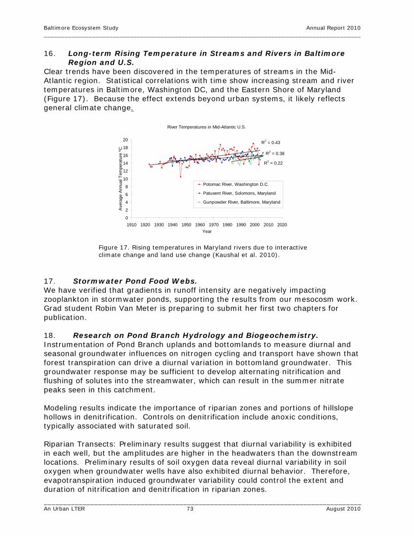
Baltimore Ecosystem Study Annual Report 2010 ____________________________________________________________________________________________
__________________________________________________________________________________ An Urban LTER 73 August 2010
River Temperatures in Mid-Atlantic U.S.
R2 = 0.43
R2 = 0.38
R2 = 0.22
0
2
4
6
8
10
12
14
16
18
20
1910 1920 1930 1940 1950 1960 1970 1980 1990 2000 2010 2020Year
Aver
age
Annu
al T
empe
ratu
re ºC
Potomac River, Washington D.C.
Patuxent River, Solomons, Maryland
Gunpowder River, Baltimore, Maryland
16. Long-term Rising Temperature in Streams and Rivers in Baltimore Region and U.S.
Clear trends have been discovered in the temperatures of streams in the Mid-Atlantic region. Statistical correlations with time show increasing stream and river temperatures in Baltimore, Washington DC, and the Eastern Shore of Maryland (Figure 17). Because the effect extends beyond urban systems, it likely reflects general climate change.
Figure 17. Rising temperatures in Maryland rivers due to interactive climate change and land use change (Kaushal et al. 2010).
17. Stormwater Pond Food Webs. We have verified that gradients in runoff intensity are negatively impacting zooplankton in stormwater ponds, supporting the results from our mesocosm work. Grad student Robin Van Meter is preparing to submit her first two chapters for publication. 18. Research on Pond Branch Hydrology and Biogeochemistry. Instrumentation of Pond Branch uplands and bottomlands to measure diurnal and seasonal groundwater influences on nitrogen cycling and transport have shown that forest transpiration can drive a diurnal variation in bottomland groundwater. This groundwater response may be sufficient to develop alternating nitrification and flushing of solutes into the streamwater, which can result in the summer nitrate peaks seen in this catchment. Modeling results indicate the importance of riparian zones and portions of hillslope hollows in denitrification. Controls on denitrification include anoxic conditions, typically associated with saturated soil. Riparian Transects: Preliminary results suggest that diurnal variability is exhibited in each well, but the amplitudes are higher in the headwaters than the downstream locations. Preliminary results of soil oxygen data reveal diurnal variability in soil oxygen when groundwater wells have also exhibited diurnal behavior. Therefore, evapotranspiration induced groundwater variability could control the extent and duration of nitrification and denitrification in riparian zones.

Baltimore Ecosystem Study Annual Report 2010 ____________________________________________________________________________________________
__________________________________________________________________________________ An Urban LTER 74 August 2010
Development and application of RHESSys model to the Baisman Run and Glyndon catchments. Simulations are quantifying the contribution of increased tree canopy cover as a BMP to reduce stormwater. One paper is under revision for Journal of the American Water Resources Association. 19. Lawn Management and Suburban Watershed Modeling. Empirical analysis of household lawn management information from survey, remote sensing and PropertyView information indicates lawn fertilization is correlated with household size and lawn size, with a negative correlation with lawn size. Small lawns tend to be fertilized more intensively than larger lawns. 20. A Dynamic Monocentric Model of Household Location and
Residential Land Development. Preliminary findings show that this model provides an alternative explanation of scattered development that is an alternative to the traditional explanations of leapfrog development and to alternative models of scattering and leapfrogging that focus on the role of local spatial interactions. Clearly differences in density and land uses, local spatial interactions and other sources of spatial heterogeneity are relevant in explaining observed patterns of scattered development. The interesting result of our model is that, despite its highly restrictive treatment of space, scattering emerges when spatial constraints that limit short run competition are considered. Specifically, we find that scattered development emerges when transportation costs are low and the variance in income is high. Under these conditions, richer households maximize their utility by bidding on outlying locations that, because they are far from the city, are not affordable by all. Scattering results in these peripheral areas because the number of households bidding is small relative to available locations. Over time, we observe a persistent coexistence of both clustering and scatteredness of urban land use. Despite its simplified treatment of space, the model is able to explain several key stylized facts regarding urbanization patterns in growing areas that are not well explained by other urban economic models that rely on a long run spatial equilibrium assumption: (1) a proportionately large and persistent pattern of scattered development over time, (2) a positive correlation between mean household income and the degree of scattered development in peripheral areas and, (3) a negative correlation between the rate of population growth and the degree of scattered development. 21. Forest Successional Studies. Forest succession in the riparian areas is changing from wetland to dry species related to hydrologic changes in those areas, whereas forest succession in the upland areas remains a progression of early successional species to late successional species in abandoned areas. Upland trees growing in riparian areas record dry and wet periods in their tree rings. (Bain and Brush, in preparation and REU 2008 studies.) 22. Development of Rating Curves for a Network of Stream Gages. To date we have collected channel-bed field surveys and generated supporting data sets for modeling all five of the new gages in the Dead Run watershed; Red Run at

Baltimore Ecosystem Study Annual Report 2010 ____________________________________________________________________________________________
__________________________________________________________________________________ An Urban LTER 75 August 2010
Painters Mill Road; and Horsehead Branch. We currently have working stage-discharge relationships for the DR2, DR4, DR5 and Red Run gages and we have sufficient field data collected in 2010 and earlier over a range of low and high flows to complete rating curves for DR1 and DR3, which we expect to have done by early fall. Horsehead Branch has been a challenge owing to the fact that its typical hydrologic response is quite subdued and there are few opportunities to map water levels at high stages. In addition, the lack of real-time data for that gage does not allow us to track water level in order to plan field site visits. With a soon-to-be installed real-time uplink for this gage we will be focusing on collecting the necessary information as flow events occur over the next several months. The two remaining gage sites, Gwynns Falls at McDonogh and Maidens Choice at Wilkens Avenue, will be addressed this fall and winter. Figure 18 illustrates the match between modeled discharge and surveyed high-water marks at the DR5 gage site for a series of low and high flows, the largest of which occurred in July 2008. The location is immediately upstream of the road and culvert. The model results have been compared with data available from direct and indirect discharge measurements and sensitivity analyses have been performed in order to assess the effect of different choices of parameter value and boundary conditions on the shape of the rating curve (Figure 19).
Figure 18. Match between modeled discharge and surveyed water levels for a series of flows at the DR5 gage site.

Baltimore Ecosystem Study Annual Report 2010 ____________________________________________________________________________________________
__________________________________________________________________________________ An Urban LTER 76 August 2010
Figure 19. DR5 rating curve showing the variation in the curves when model parameters are adjusted. The large solid circles are USGS measured discharge points, with one indirect contracted-opening discharge estimate at the high end of the curve.
23. Analysis of the Effects of Urban Infrastructure on Longitudinal
Profiles, Residence Time and Flow Paths. Preliminary results from modeling studies of the three reaches named in # 22 were presented at the Spring 2009 and Fall 2009 AGU meetings. Stepped longitudinal profiles in these channels at sites modified by urban development are associated with extremely long residence times at low flow with deep pools of virtually zero gradient separated by short riffles. During baseflow periods, water and associated constituents are stored for long periods of time separated by brief intervals where they trickle from one pool to the next. Pools at the DR4 site make up 69% of reach length and account for less than 5% of the head loss and 92-95% of the residence time along the reach at base flow. Approximately 50% of total head loss at low flow is associated with the two culvert locations along the 3100-foot surveyed profile. Preliminary modeling results for the DR4 reach of Dead Run suggest that the TUFLOW model produces residence-time estimates that are consistent with those derived by Ryan et al. (in press) from tracer tests for comparable flows along the same reach. Along the surveyed reach above and below the bridge at the Red Run gage site, pools make up 87% of reach length and account for 3-5% of the head loss and 98-99% of residence time at base flow. Two bridge crossings are associated with 32% of total head loss at low flow along the 2700-foot surveyed profile. Residence times increase exponentially at lower discharges, and residence time in pools may be 1-2 orders of magnitude higher than in riffles (Figure 20).

Baltimore Ecosystem Study Annual Report 2010 ____________________________________________________________________________________________
__________________________________________________________________________________ An Urban LTER 77 August 2010
Figure 20. Cumulative residence times for Dead Run and Red Run. The surveyed reach at Horsehead Branch has no urban infrastructure directly impinging on the channel, although there is a sanitary sewer buried beneath the adjacent forested floodplain. However, there are several debris jams formed by fallen trees along the length of the study reach. These do not exert as dominant an influence on the longitudinal profile as bridge crossings and culverts do at Dead Run and Red Run, but they do back up pools at low flow and the three prominent debris jams accounted for 37% of total head loss at low flow along the 1700-foot surveyed profile. Naturally occurring obstructions in the less urbanized channel and obstructions formed by infrastructure in urban channels may have similar kinds of impacts on residence time at low flow. However, comparative plots of percent

Baltimore Ecosystem Study Annual Report 2010 ____________________________________________________________________________________________
__________________________________________________________________________________ An Urban LTER 78 August 2010
cumulative head loss vs. percent cumulative reach length indicate that the urban channels have profiles that are more stepped with a less even distribution of gradients and head loss (Figure 21).
Figure 21. Comparison of cumulative head loss vs. cumulative reach length for three surveyed channel reaches.
Frequency analysis of flow data from the USGS gage at the Dead Run DR4 study site indicates that flows of 0.25 cfs or less occur more than 10% of the time and flows of 1 cfs or less occur almost 66% of the time. Thus the stepped profile and long residence times in pools at low flow reflect conditions that persist in this channel through much of the year. These observations run counter to the view of urban streams as geometrically and hydraulically simple conduits with little capacity for storing or processing materials provided from the upstream watershed.

Baltimore Ecosystem Study Annual Report 2010 ____________________________________________________________________________________________
__________________________________________________________________________________ An Urban LTER 79 August 2010
Findings Addressing Question 3: How can people develop and use an understanding of the metropolis as an ecological system to improve the quality of their environment, and to reduce pollution loadings to downstream air- and water-sheds? The findings and outcomes reported here deal with the feedback between ecological, physical, and social knowledge, and the behaviors and actions of individuals and institutions. This section reviews accomplishments in transferring knowledge that can inform environmental actions and decision makings, including school, non-formal education, and interaction with managers and policy makers. This question also illustrates how BES is engaged with the communities and institutions in Baltimore. 1. Ecology Teaching Study. Results of the Ecology Teaching Study, described in previous reports, are being included in manuscripts now in preparation. 2. Responsive Teaching Study. We now are analyzing the results of two years of intensive professional development with teachers, and research with the teachers and their classrooms. BES Teacher in Residence, Terry Grant, will be included in a book of case studies that is being produced from this project.

Baltimore Ecosystem Study Annual Report 2010 ____________________________________________________________________________________________
__________________________________________________________________________________ An Urban LTER 80 August 2010
Contributions 1. Within Discipline. • Streamflow data are provided on a regular basis and on special request to
individual investigators. • Pilot studies have contributed to two NSF grant proposals for collaborative work
on mosquito diversity and production in urban environments (NSF Dimensions of Biodiversity June 2010 and NSF DEB July 2010).
• Species invasion is a global environmental problem, and cities are not only
‘hotspots’ for species introduction, but the urban environment facilitates colonization and spread of non-native species. While there are several studies examining patterns of urban biodiversity in vertebrates and plants, to our knowledge this is the first attempt to synthesize urban soil invertebrate species distribution data. Understanding the ecology of non-native species and their behavior and population characteristics is essential for understanding the mechanisms of species invasion and management of invasive species. The results of this work highlight the complexity of the biotic interactions between and among species and trophic levels, and the implications for carbon transformations and long term carbon storage in soils. The model based upon BES long term soil temperature data has the novel element of incorporating land use/land cover information. It can be used for predicting the average daily soil temperature in the Baltimore area for sites with similar hydrological and soil conditions.
• Co-PI Elliott and her grad students have documented inter- and intra-city spatial
patterns in deposition of reactive nitrogen—a key eutrophication agent, ecosystem nutrient, and potentially harmful compound for human health.
• Research in the area of community and population ecology focusing on birds,
provides useful information on the ecology of birds in urban residential neighborhoods. Primary contributions have been theoretical advancements in the field of urban community ecology. This work focuses on understanding the factors that shape bird populations and communities in “Everyday Baltimore.”
• Improved understanding of the relationship between land use and land cover at
the property parcel level.
• Co-PI Chris Swan completed the submission of a conceptual framework, a community ecological perspective of urban ecosystems. This will become a chapter in the upcoming 2010 publication, “A Handbook of Urban Ecology.”
• A contribution to the discipline of urban meteorology includes the finding of a
method to model urban air temperature patterns and assess the influence of parks on air temperatures by using the model results combined with GIS analysis.

Baltimore Ecosystem Study Annual Report 2010 ____________________________________________________________________________________________
__________________________________________________________________________________ An Urban LTER 81 August 2010
• Data creation: The Baltimore metropolitan area of about 2.8 million people comprising multiple counties is studied to model the quantity and quality of urban land expansion. The processes that produce extensive urban development that has a combined pattern of compact central cities, sprawling suburbs, and fragmented exurban patches, are best studied with highly disaggregate data over a long term period of time. However, the vast majority of land use models use data that is either limited in space (e.g., aggregate data on land use shares at the county level) or time (e.g., spatially disaggregate data that spans a 5-10 year period). We are working to address these traditional data shortcomings by compiling spatially referenced, temporally rich data on land use at the micro scale to study urban development and change. We are doing this by creating unique spatial micro datasets of urbanization at a parcel level and over long time extents. Spatial micro data over time are necessary to study the underlying economic, social, institutional processes that influence individual location and land use decisions and the complex feedbacks among human decisions, land use change patterns and ecosystem services.
• Modeling: Most urban economic models of land use abstract from the multiple
sources of spatial heterogeneity and local interactions that are known to influence observed land use pattern dynamics. In addition, they rely on long run assumption of spatial equilibrium to jointly model land rents and individual location and land use decisions. While the assumption of homogeneous land eases the burden of theoretical analysis, it has substantially hindered the development of spatial economic models of land use derived from micro-foundations that can incorporate spatial heterogeneity and interactions. On the other hand, empirical models of land use change are able to incorporate any number of spatially heterogeneous variables, but do not provide the needed structural framework for modeling the evolution of land use patterns over time. Empirical agent-based models, in which land use pattern dynamics are explicitly modeled as the result of individual household, developer and landowner decisions, provide a useful modeling approach that can incorporate spatial heterogeneity and interactions. However, economic agent-based models of land markets are still in their infancy and many open challenges to this modeling approach remain. In particular, the problem of how to model land rents and the feedbacks among individual demands for location, urban land rents and land development decisions is complicated by the need to account for endogenous prices that reflect aggregate demand and supply conditions. The standard approach in urban economic models of land development is to rely on a static spatial equilibrium assumption to derive equilibrium land rents. Specifically, competition for spatially differentiated locations is assumed to result in a spatial equilibrium in which these differences are fully capitalized into equilibrium rents, making households indifferent to location. While this is a reasonable long run assumption, short and long run conditions in land and housing markets can clearly differ, e.g., due to arbitrage opportunities that may arise from a lack of competition in local land markets or search costs that impose short run constraints. Under such conditions, households are not necessarily indifferent to location and thus alternative predictions of short run equilibrium land rents and locational choices may emerge. We develop a model of urban land markets and urban spatial patterns when competition among households for residential

Baltimore Ecosystem Study Annual Report 2010 ____________________________________________________________________________________________
__________________________________________________________________________________ An Urban LTER 82 August 2010
location is spatially constrained, leading to potential differences in short and long run equilibrium rents across space. We are interested in exploring whether such a model can explain certain stylized facts regarding scattered development that are not explained by the traditional models, but that nonetheless characterize land market dynamics in many outer suburban and exurban areas. We find that accounting for short run dynamics provides an alternative explanation of scattered development that has not been considered in the literature. Our work contributes to the development of dynamic agent-based land use models that are based on a rigorous treatment of land markets while avoiding the unrealistic long run assumption of spatial equilibrium and accounting for greater realism in spatial and agent heterogeneity.
• A Graduate Student Symposium was organized by Grad Student Rep Kirsten
Schwarz and held in conjunction with the BES Annual Meeting. The symposium featured talks by BES Project Director Steward Pickett who discussed the project structure, the history of the project and urban ecology within the LTER Network, how grad students fit into the project and resources available to the students; Co-PI’s Mary Washington of the Parks & People Foundation who spoke about the BES connection to the community and communicating science to the public; Jonathan Walsh, BES Information Manager talked about graduate student representation on the BES website, data access, the internal area of the website, student calendar and blogs; Ecology Education Program Leader Bess Caplan gave an overview of the BES educational programs and opportunities for grad students to work with K-12 students. A highlight of the meeting was a talk by Saran Twombly of NSF entitled, The History, Challenges, and Future of Interdisciplinary Research at NSF. In her talk Saran discussed NSF programs, and pointed to future research and the importance of measuring critical environmental variables and changes in key human activities affecting them. The future is expected to shift to more interdisciplinary research, participatory approaches to environmental education, and public engagement. The students also had the opportunity to briefly talk about their work followed by group discussion and potential collaborations. The meeting was very well received by the students.
• The BES June 2010 Quarterly Meeting was organized by BES Grad Student Rep
Tamara Newcomer and featured BES graduate students presenting talks about their research. The meeting was well attended by students as well as other BES researchers, collaborators and interested parties. Some students had completed their research and presented findings while other students new to the project made short presentations about their planned research. It was a great opportunity for the students to gather and learn about each other’s work and where there might be additional possibilities for more collaboration. The meeting was followed by the BES Annual Picnic, organized by Parks & People Foundation, which provided an additional opportunity for more discussion between students and researchers.
• This work contributes to human dimensions of urban ecology by addressing
questions related to how the environment affects human communities,

Baltimore Ecosystem Study Annual Report 2010 ____________________________________________________________________________________________
__________________________________________________________________________________ An Urban LTER 83 August 2010
particularly as expressed through property values, and how human intervention through stewardship groups can affect environmental quality in urban areas.
2. Contributions To Other Disciplines. • Paleoecological studies show that forest cover throughout the Chesapeake
watershed has been important in maintaining the health of the estuary (Brush 2009).
• USGS data, reports, and online products are widely used in all disciplines of the
geosciences and natural-resources management communities. • As inexpensive computing devices become pervasive, scientific experiments
increasingly use on-line data acquisition and monitoring. Multiple sensors collect densely sampled data streams, making data acquisition easy; but, it requires a substantial effort to turn the raw data into a scientifically meaningful, calibrated data set. To build an end-to-end system that collects real data, and to test the system in several domain sciences is an interest for computer scientists and engineers. Wireless sensor networks will revolutionize environmental monitoring. Our comparative measurements will allow giving more accurate estimates on soil CO2 fluxes and the effects of land use and land cover on those fluxes.
• Advances in using object-based image analysis techniques to extract information
from a multi-disparate high-resolution remotely sensed datasets. • Interdisciplinary collaboration is at the heart of BES education work. By
integrating education with the BES scientists’ work and science with our education work we strengthen all aspects of the project.
3. Contributions To Education and Human Resources. • USGS provides regular development opportunities to its scientists and
technicians through its National Training Center, other regional training, and conference attendance. Cooperators, including BES investigators, are eligible to participate in USGS training programs on a space-available basis.
• Through all of BES education work, from the My City’s An Ecosystem curriculum
for KidsGrow to ecology units for high school students to work with IGERT graduate students, the project contributes to the development of an ecologically literate citizenry in Baltimore, and, potentially, to a new generation of urban ecologists.
• Seventeen students used the results from their BES research to prepare and
successfully defend theses and obtain advanced degrees during the period 2009-2010.

Baltimore Ecosystem Study Annual Report 2010 ____________________________________________________________________________________________
__________________________________________________________________________________ An Urban LTER 84 August 2010
4. Contributions To Research and Higher Education • CUERE (UMBC’s Center for Urban Environmental Research and Education) serves
as host to the field operations of the Baltimore Ecosystem Study, providing lab, office, and meeting space to BES PIs and students as a subcontractor to the Cary Institute of Ecosystem Studies. CUERE’s GIS Laboratory provides spatial data analysis services to BES researchers as needed. In addition, CUERE provides BES with an academic link to UMBC, whereby several of the BES PIs serve as adjunct faculty at UMBC, and UMBC faculty and students work on BES-related projects.
• CUERE has continued to be instrumental in leveraging the presence of the BES
on campus to increase related research activities. In August 2009, CUERE received a new award entitled, “Integrating Real-Time Chemical Sensors into Understanding of Groundwater Contributions to Surface Water in a Model Urban Observatory.” PI: C. Welty, Co-PIs: S. Kaushal, M. Maxwell, L. Band, P. Groffman, K. Belt, A. Miller, M. McGuire, and J. Duncan.
• In July 2010, CUERE received preliminary word from NSF on awards under the
Water Sustainability and Climate program and NSF MRI. • BES research continues to provide critical examples for Dr. Cadenasso’s lectures
in the core upper division undergraduate course “Urban Ecology” at the University of California (UC), Davis. Publications produced as a result of the BES are also frequently included as required course reading. During the past academic year, sixteen undergraduates, graduates, and returning students enrolled in the course and represented five different majors from two colleges.
• BES research also provided illustrations of ecological concepts for the lectures in
a graduate course “Ecosystems and Landscapes” at UC Davis. This is a required core course for all graduate students in this area of emphasis. For the first time, the course was also available to undergraduates.
• As part of a seminar visit to NYU (see presentations), Dr. Cadenasso spent two
hours in the classroom discussing the interdisciplinary nature of BES as well as specific findings from the research with graduate students in a Sustainable Development course.
• BES research was critical to guest lectures Dr. Cadenasso provided during the
past year in 1) Introduction to Environmental Horticulture and Urban Forestry, 2) Sustainable Landscape Design, and 3) graduate seminar entitled “Landscape and Community Connectivity” sponsored by the Road Ecology Institute at UC Davis.
• The USGS MD-DE-DC Water Science Center resides on the campus of the
University of Maryland Baltimore County, and its facilities and resources are available to students, staff, and other BES researchers.

Baltimore Ecosystem Study Annual Report 2010 ____________________________________________________________________________________________
__________________________________________________________________________________ An Urban LTER 85 August 2010
• Initial mosquito data have already been incorporated into education activities and curriculum, as described above. One undergraduate research student (REU) participated in data collection and analysis in the first year of this work.
• Results of Isotopic studies have important implication for those interested in
improving water quality and management stormflow runoff. Additionally, these results will be of great interest to those modeling air quality.
• Development of new GIS datasets and OBIA routines.
• Co-PI Chris Boone has drawn on his research data sources and the methods in
his urban dynamics course.
• Co-PI Sujay Kaushal taught a course “Principles and Practices of Ecosystem Restoration” at University of Maryland College Park, which had a module on urban ecosystems. The course is well enrolled by both graduate students and local and state water quality managers.
• Co-PI Andy Miller has incorporated BES-related research findings into both
graduate and undergraduate courses at UMBC.
• Co-PI Chris Swan mentored several graduate students on research focusing on (1) both on the genetic and taxonomic patterns in biodiversity in urban ecosystems; (2) the consequence of road deicer runoff on urban stormwater pond food-webs; (3) community assembly in urban stream networks, and the role of restoration in regulating patterns in biodiversity. Swan also participated in the RET mentoring program, mentoring a secondary school chemistry teacher. The teacher performed an experiment and developed curricula examining how road deicers influence microbial processing of detritus in streams.
• Co-PI Austin Troy taught a mixed graduate and undergraduate course at the
University of Vermont entitled, “Integrating GIS and Statistics” in Spring 2010, which utilized data, methods, and case studies from the Baltimore Ecosystem Study. The class resulted in a number of projects on BES. See website http://www.uvm.edu/envnr/gradgis/advanced/ Troy also included a segment on BES in undergraduate spring 2010 course entitled, “Ecosystem Management.” These courses educate graduate and undergraduate students about BES and methods used in BES research including GIS and spatial statistics.
• Co-PI Larry Band has taught a short course on the RHESSys application in May
of 2010 with another scheduled for later September 2010.
• Baltimore City Community College (BCCC) Internship: Co-PI Ken Belt has continued to help with aspects of the new environmental science program at BCCC (field trips, providing contacts, advice and information, etc.). Belt also set up an internship program for the spring semester 2010; this involved instruction by various researchers on USFS and BES as well as field visits to a variety of field research sites, and was a part of a required course for the environmental

Baltimore Ecosystem Study Annual Report 2010 ____________________________________________________________________________________________
__________________________________________________________________________________ An Urban LTER 86 August 2010
science program. Belt worked, for the most part, through Hydrology instructor R. Danforth.
• Graduate Course: Sustainability in Action: Boston. Course 11.375, Department
of Urban Studies and Planning, MIT. Lead professor: J. Layzer, co-professors: S. Pickett, K. Seidman. Spring semester 2010. Insights from BES were used in field trip and discussion components of this graduate course.
• Special topics in urban ecology were provided to Alexis Schulman, PhD Student,
Department of Urban Studies and Planning, MIT (“Special Research Topics: Resilience and Complexity in Urban Systems,” Fall 2009) and to Michele Romolini, PhD Student, University of Vermont (Special Topics: “Urban Ecology,” Fall 2009).
• Co-PI Charlie Nilon makes extensive use of examples from research with BES in his undergraduate and graduate courses. Examples and data from the bird monitoring project are used as an example of a community ecology study in a non-majors natural resources class. Data from the monitoring project in also used in his urban wildlife conservation class that is taught to undergraduates and graduate students.
Training/Development • BES Co-PIs and researchers have trained interns, graduate and undergraduate
students, REU students, K-12 teachers and others in various aspects of BES research.
• CUERE continues to host UMBC’s IGERT program “Water in the Urban
Environment.” As of August 2010, thirteen of the twenty PhD IGERT trainees are working with BES investigators as their mentors (Groffman (1), Swan (3), Welty (1), Pouyat (2), Kaushal (1), Ghosh (1), Miller (2), Ellis (2)). The IGERT trainees have interacted with many BES investigators and other graduate students in a number of ways and the IGERT has therefore significantly contributed to building the graduate student population affiliated with BES.
• CUERE trained two REU students and one high school student in summer of
2010 under NSF grant 0854307 in lab, field, and computer techniques. • HERCULES land cover model is providing training and development for three
post-doctoral researchers and two graduate student researchers. One post-doc specializes in remote sensing, GIS, and spatial analysis and he is using these methods to develop further expertise in landscape ecology theory. The second post-doc is a social scientist and she is working with social and ecological data to investigate the links and feedbacks between the two in an urban setting. Working with ecological concepts and data is new for her. The third post-doc is developing research in the area of ecosystem services and environmental justice. The graduate students have been able to learn basic GIS and spatial analysis skills. Both students are using HERCULES in their dissertation research.
Baltimore Ecosystem Study Annual Report 2010 ____________________________________________________________________________________________
__________________________________________________________________________________ An Urban LTER 87 August 2010
• Dr. Cadenasso is working with graduate students and faculty in the community
development program at UC Davis to encourage collaborative cross disciplinary research activities on regional change, urbanization of the CA landscape, and environmental justice issues.
• Co-PI Dr. Grace Brush has trained student researchers to identify plants, collect field data and to objectively sample vegetation in the field.
• One of Co-PI Emily Elliott’s graduate students was trained in methods using
passive samplers to quantify gaseous reactive nitrogen concentrations, mass spectrometry, ion chromatography, and flux calculations as part of the research.
• USDA Forest Service NRS-8 and Woodrow Wilson High School/Benjamin
Harrison Society Teacher Workshop, Baltimore, MD—July 2010. Several teachers from the Woodrow Wilson High School of the Washington, DC Public School System participated in a teacher workshop held at the University of Maryland, Baltimore County, Center for Urban Environmental Research and Education (UMBC-CUERE) conducted by Quin Holifield, of the USDA Forest Service, NRS-8 and Nic Saliendra a Forest Biometeorologist affliated with UMBC-CUERE and the USDA Forest Service. Teachers were introduced to the concepts of the new ECO I-Tree, urban soils, and global warming. Lesson plans and handouts were disseminated. During the discussion, an urban soils curriculum and a global warming curriculum based on the Ameri-Flux data website and on information from John Hom of USDA Global Change Program, was developed. The newly developed curriculum will be implemented during the 2010-2011 academic year. The majority of the activities will take place at Rock Creek Park. Approximate 196 students will be enrolled in the Urban Ecology Course that will be taught this school year.
• Chandler Denison completed his MS this spring and a manuscript on his findings
is being prepared. Wildlife research continues to provide opportunities for training and development. One PhD student, Dylan Allen, will be collecting data in Baltimore in spring 2011 focused on reproductive ecology of opossums.
• Co-PI Paige Warren contributed to the training and development of graduate
student, Susannah Lerman. • Training at other universities and LTER sites on the use and application of
object-based image analysis techniques. • A graduate student and post-doctoral fellow were trained in examination and
use of historical sources of social and environmental data, spatial analysis, and integrated quantitative and qualitative methods for answering socio-ecological questions.
• Co-PI Mary Washington of the Parks & People Foundation planned, coordinated
and hosted the BES Annual Staff Field Safety and Community Awareness

Baltimore Ecosystem Study Annual Report 2010 ____________________________________________________________________________________________
__________________________________________________________________________________ An Urban LTER 88 August 2010
Training Workshop, held on June 7th, 2010 at UMBC-TRC. There were approximately fifteen researchers and interns trained.
• Parks & People supervised and trained undergraduate and graduate student
interns in the following projects: o Leading Watershed Ecology Education enrichment program with Parks &
People’s SuperKids Camp. o Organizing and capacity-building strategies for Watershed 263
Stakeholders Council. o Maintaining Community Greening and Gardens survey and Database. o Expanding Green Career Ladder enrichment activities for BRANCHES
summer and afterschool youth forestry training and employment program.
o Analyzing Green Career Ladder evaluation tools for BRANCHES and MD Civil Justice Corps.
o Leading environmental and ecological sciences field studies for BRANCHES and CJC summer youth forestry program.
o Collected data and entered it on spreadsheets and GIS maps of ten neighborhood tree surveys.
• Parks & People also conducted community trainings on:
o Community Grants program opportunities, o Capacity building and leadership development in Watershed 263, o Watershed and Stormdrain Awareness, o Rainbarrel Construction, o Community Greening trainings in planning and carrying out community
restoration projects. 5. Contributions Beyond Science and Engineering. • Co-PI Grace Brush has encouraged students to connect with the environment
(their habitat) by keeping journals of everyday observations, which will eventually lead to long term data sets of various environmental variables including precipitation, time of snowfall, time of bird appearances (migratory patterns) and plant phenology (time of flowering and leafing), etc.
• USGS continues to add real-time capabilities to stream-gaging stations to
provide flood warning and a regular provisional data stream for recreation, education, and numerous other water-resources management applications.
• Supported State of Maryland tree planting and urban canopy tree cover
initiatives to offset carbon dioxide and reduce emissions.
• Collaboration with the Maryland Science Center led to training of six citizen scientists in collection of air temperature data, thus expanding their knowledge of climate and meteorological measurements.

Baltimore Ecosystem Study Annual Report 2010 ____________________________________________________________________________________________
__________________________________________________________________________________ An Urban LTER 89 August 2010
• Kurt Kocher of the Baltimore City Department of Public Works, in revamping the website for the Bureau of Water and Wastewater, requested the use of research by Co-PI Christopher Boone on Baltimore’s sewers.
• Additional contributions include management recommendations for tree canopy
cover to support a key guild of bird species, woodpecker and cavity nesting birds.
• Several activities shared insights, data, and approaches from the BES LTER with
audiences of regional planners, urban designers, and artists concerned with sustainability and environmental justice. These included the following: (1) Ecological Society of America, First Millennium Conference. Water-Ecosystem Services, Drought and Environmental Justice. Athens, Georgia, November, 2009; (2) Humane Metropolis Baltimore, June 11, 2009; Maryland Historical Society; (3) Baltimore as Watershed: The Approach of the Baltimore Ecosystem Study LTER. WaterWays: Confluence of Art, Science, Policy and Philosophy. University of North Texas, 3 March 2010; (4) “Ecologies? A View of the Structure and Status of Ecological Science in Context of Design.” Critical Ecologies: On the Biological, Horticultural, and Anthropological Antecedents to Design. Graduate School of Design, Harvard University, 2-3 April 2010; and (5) “The Creation and Use of Ecological Space: A Biologist’s Perspective from the Wild to the Urban.” Department of Urban Studies and Planning, MIT, 9 March 2010.
Publications and Products Journal Publications Boone, C.G., M.L. Cadenasso, J.M. Grove, K. Schwarz, G.L. Buckley. 2010. Landscape, vegetation characteristics, and group identity in an urban and suburban watershed: why the 60s matter. Urban Ecosystems. 13(3):255-271. doi:10.1007/s11252-009-0118-7. Carrion-Flores, C., E.G. Irwin. 2010. Identifying spatial interactions effect in the presence of spatial error autocorrelation: an application to land use spillovers. Energy and Resource Economics. 32(2):135-153. doi:10.1016/j.reseneeco.2009.11.009. Chapin III, F.S., S.R. Carpenter, G.P. Kofinas, C. Folke, N. Abel, W.C. Clark, P. Olsson, D.M. Stafford Smith, B. Walker, O.R. Young, F. Berkes, R. Biggs, J.M. Grove, R. L. Naylor, E. Pinkerton, W. Steffen, F.J. Swanson. 2010. Ecosystem stewardship: sustainability strategies for a rapidly changing planet. Trends in Ecology and Evolution. 25(4):241-249. doi:10.1016/j.tree.2009.10.008. Claessens, L., C.L. Tague, L.E. Band, P.M. Groffman, S.T. Kenworthy. 2009. Hydro-ecological linkages in urbanizing watersheds: an empirical assessment of in-stream nitrate loss and evidence of saturation kinetics. Journal of Geophysical Research Biogeosciences. 114(G04016). doi:10.1029/2009JG001017.

Baltimore Ecosystem Study Annual Report 2010 ____________________________________________________________________________________________
__________________________________________________________________________________ An Urban LTER 90 August 2010
Claessens, L., C.L. Tague. 2009. Transport-based method for estimating in-stream nitrogen uptake at ambient concentration from nutrient addition experiments. Limnology and Oceanography:Methods. 7(December):811-822. Claessens, L., C.L. Tague, P.M. Groffman, J.M. Melack. 2010. Longitudinal assessment of the effect of concentration on stream N uptake rates in an urbanizing watershed. Biogeochemistry. 98:63-74. doi:10.1007/s10533-009-9376-y. Claessens, L., C.L. Tague, P.M. Groffman, J.M. Melack. 2010. Longitudinal and seasonal variation of stream N uptake in an urbanizing watershed: effect of organic matter, stream size, transient storage and debris dams. Biogeochemistry. 98:45-62. doi:10.1007/s10533-009-9375-z. Dandois, J.P., E.C. Ellis. 2010. Remote sensing of vegetation structure using computer vision. Remote Sensing. 2(4 Special Issue Ecological Status and Change by Remote Sensing):1157-1176. doi:10.3390/rs2041157. Findlay, S.E.G., W.H. McDowell, D.T. Fischer, M.L. Pace, N. Caraco, S.S. Kaushal, K.C. Weathers. 2010. Total carbon analysis may overestimate organic carbon content of fresh waters in the presence of high dissolved inorganic carbon. Limnology and Oceanography:Methods. 8:196-201. doi:10.4319/lom.2010.8.196. Gift, D.M., P.M. Groffman, S.S. Kaushal, P.M. Mayer. 2010. Denitrification potential, root biomass, and organic matter in degraded and restored urban riparian zones. Restoration Ecology. 18(1):113-120. doi:10.1111/j.1526-100X.2008.00438.x. Irwin, E.G., C. Jayaprakash, D.K. Munroe. 2009. Towards a comprehensive model of urban spatial dynamics. Landscape Ecology. 24(9):1223–1236. doi:10.1007/s10980-009-9353-9. Irwin, E.G., K.P. Bell, N.E. Bockstael, D.A. Newburn, M.D. Partridge, J. Wu. 2009. The economics of urban-rural space. Annual Review of Resource Economics. 1(1):435-462. doi:10.1146/annurev.resource.050708.144253. Irwin, E.G. 2010. New directions for urban economic models of land use change: incorporating spatial dynamics and heterogeneity. Journal of Regional Science. 50(1):65-91. doi:10.1111/j.1467-9787.2009.00655.x. Kaushal, S.S., G.E. Likens, N.A. Jaworski, M.L. Pace, A.M. Sides, D.A. Seekell, K.T. Belt, D.T. Secor, R.L. Wingate. 2010. Rising stream and river temperatures in the United States. Frontiers in Ecology and Environment. 8(9):461-466. doi:10.1890/090037. Klocker, C.A., S.S. Kaushal, P.M. Groffman, P.M. Mayer, R.P. Morgan. 2009. Nitrogen uptake and denitrification in restored and unrestored streams in urban Maryland, USA. Aquatic Sciences. 71(4):411-424. doi:10.1007/s00027-009-0118-y.

Baltimore Ecosystem Study Annual Report 2010 ____________________________________________________________________________________________
__________________________________________________________________________________ An Urban LTER 91 August 2010
Lord, C., K. Norquist. 2010. Cities as emergent systems: race as a rule in organized complexity. Environmental Law. 40(2):551-596. Martin, M.D., M. Chamecki, G.S. Brush. 2010. Anthesis synchronization and floral morphology determine diurnal patterns of ragweed pollen dispersal. Journal of Agriculture and Forest Meteorology. 150(9):1307-1317. doi:10.1016/j.agrformet.2010.06.001 Mayer, P.M., P.M. Groffman, E.A. Striz, S.S. Kaushal. 2010. Nitrogen dynamics at the ground water-surface water interface of a degraded urban stream. Journal of Environmental Quality. 39:810-823. McGrath, B., V. Marshall. 2009. New patterns in urban design. Architectural Design. 79(6):48-53. doi:10.1002/ad.978. Merse, C.L., G.L. Buckley, C.G. Boone. 2009. Street trees and urban renewal: A Baltimore case study. The Geographical Bulletin. 50(2):65-82. Ntelekos, A.A., M. Oppenheimer, J.A. Smith, A.J. Miller. 2010. Urbanization, climate change and flood policy in the United States. Climate Change. doi:10.1007/s10584-009-9789-6. Pace, M.L., S.E. Hampton, K.E. Limburg, E.M. Bennett, E.M. Cook, A.E. Davis, J.M. Grove, K.Y. Kaneshiro, S.L. LaDeau, G.E. Likens, D.M. McKnight, D.C. Richardson, D.L. Strayer. 2010. Communicating with the public: opportunities and rewards for individual ecologists. Frontiers in Ecology and Environment. 8(6):292-298. doi:10.1890/090168. Ryan, R.J., P.C. Larson, C. Welty. 2010. The logistics and mechanics of conducting tracer injection experiments in urban streams. Urban Ecosystems. Online Savva, Y., K. Szlavecz, R.V. Pouyat, P.M. Groffman, G. Heisler. 2010. Effects of land use and vegetation cover on soil temperature in an urban ecosystem. Soil Science Society of America. 74(2):469-480. doi:10.2136/sssaj2009.0107. Shochat, E., S.B. Lerman, J.M. Anderies, P.S. Warren, S.H. Faeth, C.H. Nilon. 2010. Invasion, competition, and biodiversity loss in urban ecosystems. BioScience. 60(3):199-208. Smith, M.L., W. Zhou, M.L. Cadenasso, J.M. Grove, L.E. Band. 2010. Evaluation of the National Land Cover Database for hydrologic applications in urban and suburban Baltimore, Maryland. Journal of the American Water Resources Association. 46(2):429-442. doi:10.1111/j.1752-1688.2009.00412.x. Terzis, A.R., R. Musaloiu-E, J. Cogan, K. Szlavecz, A.S. Szalay, R.J. Gray, S. Ozer, C.M. Liang, J. Gupchup, R. Burns. 2010. Wireless sensor networks for soil science. International Journal of Sensor Networks. 7(1/2):53-70. doi:10.1504/IJSNET.2010.031850.

Baltimore Ecosystem Study Annual Report 2010 ____________________________________________________________________________________________
__________________________________________________________________________________ An Urban LTER 92 August 2010
Zhou, W., K. Schwarz, M.L. Cadenasso. 2010. Mapping urban landscape heterogeneity: agreement between visual interpretation and digital classification approaches. Landscape Ecology. 25(1):53-67. doi:10.1007/s10980-009-9427-8. Journals-In Press Peters, D.P.C., A.E. Lugo, F.S. Chapin III, S.T.A. Pickett, M. Duniway, A.V. Rocha, F.J. Swanson, C. Laney, J. Jones. 2010 In press. Unpacking complexities of disturbance: insights from cross-system comparisons. BioScience. Pickett, S.T.A., M.L. Cadenasso, J.M. Grove, C.G. Boone, E.G. Irwin, P.M. Groffman, S.S. Kaushal, V. Marshall, B.P. McGrath, C.H. Nilon, R.V. Pouyat, K. Szlavecz, A. Troy, P.S. Warren. 2010 In press. Urban ecological systems: foundations and a decade of progress. Journal of Environmental Management. Ryan, R.J., C. Welty, P.C. Larson. 2010 In press. Variation in surface water-groundwater exchange with land use in an urban stream. Journal of Hydrology. doi:10.1016/jhydrol.2010.06.004. Journals-Accepted Brady, M., E.G. Irwin. 2010 Accepted. Accounting for spatial effects in economic models of land use. Environmental and Resource Economics. Meierdiercks, K.L., J.A. Smith, M.L. Baeck, A.J. Miller. 2010 Accepted. Heterogeneity of hydrologic response in urban watersheds. Journal of the American Water Resources Association. Szlavecz, K., M. McCormick, L. Xia, J. Saunders, T. Morcol, D.F. Whigham, T.R. Filley. 2010 Accepted. Ecosystem effects of non-native earthworms in Mid-Atlantic deciduous forests. Biological Invasions. Journals-Submitted Bain, D.J., R.V. Pouyat, I.D. Yesilonis. 2010 Submitted. Metal concentrations in urban riparian sediments along an urbanization gradient. Biogeochemistry. Christopher, T., A. Troy. 2010 Submitted. A multilevel, property hedonic analyses of parks in Baltimore, MD. Spatial Economic Analysis. Crook, N., C. Welty, R. Knight. 2010 Submitted. Geophysical characterization of an urban watershed. Journal of Environmental and Engineering Geophysics. Huang, G., W. Zhou, M.L. Cadenasso. 2010 Submitted. Is everyone hot in the city? Spatial patterns of land surface temperatures, land cover, and neighborhood socioeconomic characteristics in Baltimore City, MD. Journal of Environmental Management.

Baltimore Ecosystem Study Annual Report 2010 ____________________________________________________________________________________________
__________________________________________________________________________________ An Urban LTER 93 August 2010
Lindner, G.A., A.J. Miller. 2010 Submitted. Hydraulic modeling of stage-discharge relationships in urban streams. Journal of Hydrologic Engineering. McGuire, M.P., V. Janeja, A. Gangopadhyay. 2010 Submitted. Mining large environmental sensor datasets with spatio-temporal neighborhoods. GeoInformatica. Meierdiercks, K.L., J.A. Smith, M.L. Baeck, A.J. Miller. 2010 Submitted. Flood frequency on an urban drainage network. Journal of Hydrologic Engineering. Meierdiercks, K.L., J.A. Smith, M.L. Baeck, A.J. Miller. 2010 Submitted. Analyses of urban drainage network structure and its impact on hydrologic response. Journal of the American Water Works Association. Mittman, T., L.E. Band, T. Huang, M.L. Smith. 2010 Submitted. Extending process-based hydrologic modeling to the suburban landscape: the potential of proxy-catchment calibration. Journal of American Water Resource Association. Nilon, C.H. 2010 Submitted. Urban biodiversity: conservation and management. Landscape and Ecological Engineering. Pickett, S.T.A., G.L. Buckley, S.S. Kaushal, Y. Williams. 2009 Submitted. Social-ecological science in the humane metropolis. Urban Ecosystems. Zhou, W., G. Huang, S.T.A. Pickett, M.L. Cadenasso. 2010 Submitted. 90 years of forest cover change in the urbanizing Gwynns Falls watershed, Baltimore, Maryland: spatial and temporal dynamics. Landscape Ecology. Zhou, W., M.L. Cadenasso. 2010 Submitted. Effects of patch characteristics and within patch heterogeneity on the accuracy of urban land cover classification from visual interpretation. Landscape Ecology. Books-Accepted Buckley, G.L. 2010 Accepted. America’s conservation impulse: A century of saving trees in the Old Line State. Center for American Places. Santa Fe. Book Chapters Ehrenfeld, J.G., E.K. Stander. 2010. Habitat function in urban riparian zones. Pages 103-118. In: Aitkenhead-Peterson, J., A. Volder, eds. Urban Ecosystem Ecology, Agronomy Monograph 55. American Society of Agronomy, Crop Science Society of America, and Soil Science Society of America (ASA-CSSA-SSSA). Madison, WI. Heisler, G.M. 2010. Health impacts of ultraviolet radiation in urban ecosystems: a review. Pages 331-369. In: Gao, W., D.L. Schmoldt, J.R. Slusser, eds. UV radiation in global climate change: measurements, modeling and effects on ecosystems. Springer-Verlag and Tsinghua University Press. New York and Beijing.

Baltimore Ecosystem Study Annual Report 2010 ____________________________________________________________________________________________
__________________________________________________________________________________ An Urban LTER 94 August 2010
Heisler, G.M., A.J. Brazel. 2010. The urban physical environment: temperature and urban heat islands. Pages 29-56. In: Aitkenhead-Peterson, J., A. Volder, eds. Urban Ecosystem Ecology, Agronomy Monograph 55. American Society of Agronomy, Crop Science Society of America, and Soil Science Society of America (ASA-CSSA-SSSA). Madison, WI. Marshall, V. 2010. Onset, event and release. Pages 185-190. In: Bolchover, J., J.D. Solomon, eds. Sustain and Develop, 306090, vol. 13 Architectural Press. Princeton, NJ. McGrath, B. 2010. Diagrams of the city/the city as diagram In: Garcia, M., ed. Diagrams of architecture: AD Reader. John Wiley & Sons. London. McGuire, M.P., V.P. Janeja, A. Gangopadhyay. 2010. Spatiotemporal neighborhood discovery for sensor data. Pages 203-225. In: Gaber, M.M., ed. Knowledge Discovery from Sensor Data, vol. 5840. Springer. Berlin. McGrath, B. 2010. Indigenous and scientific water management design: experiences in Thailand and Baltimore. In: Fabian, L., P. Vigano, eds. Extreme city: climate change and the transformation of the waterscape. Institute for Urbanism and Architecture. Venice. Pickett, S.T.A. 2010. The wild and the city. Pages 153-159. In: Fearn, E., ed. State of the wild: a global portrait 2010-2011 Island Press. Washington, DC. Pouyat, R.V., K. Szlavecz, I.D. Yesilonis, P.M. Groffman, K. Schwarz. 2010. Chemical, physical and biological characteristics of urban soils. Pages 119-152. In: Aitkenhead-Peterson, J., A. Volder, eds. Urban Ecosystem Ecology, Agronomy Monograph 55. American Society of Agronomy, Crop Science Society of America, and Soil Science Society of America (ASA-CSSA-SSSA). Madison, WI. Shochat, E., S. Lerman, E. Fernandez-Juricic. 2010. Birds in urban ecosystems: population dynamics, community structure, biodiversity, and conservation. Pages 75-86. In: Aitkenhead-Peterson, J., A. Volder, eds. Urban Ecosystem Ecology Agronomy Monograph 55. American Society of Agronomy, Crop Science Society of America, and Soil Science Society of America (ASA-CSSA-SSSA). Madison, WI. Stander, E.K., J.G. Ehrenfeld. 2010. Urban riparian function. Pages 253-276. In: Aitkenhead-Peterson, J., A. Volder, eds. Urban Ecosystem Ecology, Agronomy Monograph 55. American Society of Agronomy, Crop Science Society of America, and Soil Science Society of America (ASA-CSSA-SSSA). Madison, WI. Thaitakoo, D., B. McGrath. 2010. Indigenous and scientific water management: fusing research on urban headwater transformations in Northern Thailand and Metropolitan Baltimore. Pages 225-240. In: Shaw, R., D. Thaitakoo, eds. Water Communities. Emerald Publishing Group. London.
Baltimore Ecosystem Study Annual Report 2010 ____________________________________________________________________________________________
__________________________________________________________________________________ An Urban LTER 95 August 2010
Book Chapters-In Press Canuel, E.A., G.S. Brush, T.M. Cronin, R. Lockwood, A.R. Zimmerman. In press. Understanding interactions between climate, anthropogenic activities and the environment. In: Gibson, J., ed. Application of paleoenvironmental techniques in estuarine studies, Springer. Costanza, R. In press. The value of a restored earth and its contribution to a sustainable and desirable future. In: Comin, F.A., ed. Ecological restoration: a global challenge, Cambridge University Press. Szlavecz, K., P.S. Warren, S.T.A. Pickett. In press. Biodiversity in the urban landscape. In: Cincotta, R., L. Gorenflo, eds. Human demography and biodiversity: ecological studies, Springer. Swan, C.M., S.T.A. Pickett, K. Szlavecz, P.S. Warren, K.T. Willey. In press. Biodiversity and community composition in urban ecosystems: coupled human, spatial and metacommunity processes. In: Holyoak, M., M.A. Leibold, R.D. Holt, eds. Metacommunities: spatial dynamics and ecological communities. University of Chicago Press. Chicago. Warren, P.S., S. Harlan, C.G. Boone, S.B. Lerman, E. Shochat, A.P. Kinzig. In press. Urban ecology and human social organization. Pages 172-201. In: Gaston, K., ed. Urban Ecology, Cambridge University Press. Book Chapters Accepted Buckley, G.L., C.G. Boone. Accepted. To promote the material and moral welfare of the community: Neighborhood Improvement Associations in Baltimore, Maryland, 1900-1945. In: Rodger, R., G. Massard-Guilbaud, eds. Environmental and social justice in the city: historical perspectives. Cambridge: White Horse. Reports Nowak, D.J., R.E. Hoehn, R.V. Pouyat, I.D. Yesilonis. 2009. The urban forest within Baltimore County's urban-rural demarcation line. USDA Forest Service. USGS. 2010. Water resources data for the United States, water year 2009. US Geological Survey. Theses/Dissertations Chevalier, M. 2009. Toxic playground: a retrospective study of environmental justice in Baltimore Maryland. Ohio University, Athens, OH. Delaney, K.M. 2009. Organic nitrogen and carbon transformations in a stream network of Chesapeake Bay watershed. University of Maryland, College Park, MD.

Baltimore Ecosystem Study Annual Report 2010 ____________________________________________________________________________________________
__________________________________________________________________________________ An Urban LTER 96 August 2010
Ellis, A. 2009. Analyzing canopy cover effects on urban temperatures in Baltimore City, MD. State University of New York, Syracuse, NY. Mittman, T.S. 2009. Assessing the impact of the urban tree canopy on streamflow response: an extension of physically based hydrologic modeling to the suburban landscape. University of North Carolina, Chapel Hill, NC. Stanko, G.M. 2009. Longitudinal variability in streamwater chemistry and carbon and nitrogen dynamics in restored and degraded urban stream networks. University of Maryland, College Park, MD. Voigt, B. 2009. Models of anthropogenic influence on the landscape. University of Vermont, Burlington, VT. Battaglia, M.J. 2010. A multi-methods approach to determining appropriate locations for tree planting in two of Baltimore's tree-poor neighborhoods. Ohio University, Athens, OH. Corrigan, M.P. 2010. Growing what you eat: developing community gardens and improving food security. Ohio University, Athens, OH. Denison, C.B. 2010. Effects of socioeconomics on European starling (Sturnus vulgaris) abundance in Baltimore Maryland. University of Missouri, Columbia, MO. Felson, A.J. 2010. Suburbanization and amphibian metapopulations. Rutgers University, New Brunswick, NJ. Pierce, E. 2010. The historic roots of green urban policy in Baltimore County, Maryland. Ohio University, Athens, OH. Schwarz, K. 2010. The spatial distribution of lead in urban residential soil and correlations with urban land cover of Baltimore, Maryland. Rutgers University, New Brunswick, NJ. Smith, M.L. 2010. Heterogeneity in the urban landscape: Impacts on hydrologic processes and nitrogen pollution. University of North Carolina, Chapel Hill, NC. Abstracts Allen, D., C.H. Nilon. 2009. Reproductive strategies of opossums in an urbanized environment. International Symposium on Urban Wildlife and the Environment. 21-24 June. Amherst, MA. Belt, K., S.S. Kaushal, C.M. Swan, W.P. Stack, R. Pouyat, P. Groffman. 2009. Urban stream continuums and gutter subsidies: the effects of upland riparian zones and engineered "urban karst" on organic matter and lotic ecology. Bridging the Gap: Connecting Ecological Research and Restoration Practice, 13-14 March 2009, College of New Jersey, Ewing, NJ.

Baltimore Ecosystem Study Annual Report 2010 ____________________________________________________________________________________________
__________________________________________________________________________________ An Urban LTER 97 August 2010
Belt, K.T., D.C. Outen, A. Hairston-Strang, C. Howells. 2009. Forests and water: monitoring & research: the pursuit of useful knowledge in a changing world. Maryland Water Monitoring Council 15th Annual Conference, 3 December 2009, North Linthicum, MD. Berkowitz, A.R., L.M. Jablonski, G.A. Middendorf. 2010. Diversifying the Ecological Village: Lessons from SEEDS and the Baltimore Ecosystem Study. Ecological Society of America 95th Annual Meeting; 6 August 2010, Pittsburgh, PA. Bhaskar, A., C. Welty. 2010. Water balances in urbanized metropolitan Baltimore. CUAHSI 2nd Biennial Colloquium on Hydrologic Science and Engineering, 19-22 July 2010, Boulder, CO. Bhaskar, A., C. Welty, R. Maxwell. 2009. Urban watershed modeling across landscape scales. Eos Trans. AGU, 90(52), Fall Meet. Suppl., Abstract H43A-0996, 14-17 December 2009, San Francisco, CA. Bigsby, K., J.M. Grove, M.R. McHale. 2010. A spatially explicit analysis of net primary production in urban ecosystems. Ecological Society of America 95th Annual Meeting, 4 August 2010, Pittsburgh, PA. Brush, G.S. 2010. Historical agricultural transitions and changes in material fluxes from the landscape. Ecological Society of America 95th Annual Meeting, 5 August 2010, Pittsburgh, PA. Buckley, G.L., M. Chevalier-Flick. 2010. Toxic playground: the story of Baltimore's Swann Park. Association of American Geographers Annual Meeting, 16 April 2010, Washington, DC. Burgess, J.L., C.M. Swan, K. Szlavecz. 2010. Impacts of soil resource base on oak seedling functional response. Ecological Society of America 95th Annual Meeting, 4 August 2010, Pittsburgh, PA. Chang, C.-H., K. Szlavecz, S.L. Pitz, C. Csuzdi, M.K. McCormick, T.R. Filley. 2010. Recent increase in earthworm abundance in Mid-Atlantic deciduous forests. Ecological Society of America 95th Annual Meeting, 4 August 2010, Pittsburgh, PA. Dandois, J.P., E.C. Ellis. 2010. Remote sensing of vegetation structure using computer vision. Ecological Society of America 95th Annual Meeting, 3 August 2010, Pittsburgh, PA. Duan, S., S.S. Kaushal, P.M. Groffman, S.E.G. Findlay, M.M. Grese, T.A. Newcomer, M. Pennino, C. Sperling. 2010. Effects of temperature and source on organic matter leaching and decomposition in Baltimore urban area. Ecological Society of America 95th Annual Meeting, 5 August 2010, Pittsburgh, PA. Duncan, J.M., L.E. Band. 2010. Quantifying landscape controls on riparian biogeochemical hotspots in a Piedmont forested catchment. CUAHSI 2nd Biennial Colloquium on Hydrologic Science and Engineering, 19-22 July 2010, Boulder, CO.

Baltimore Ecosystem Study Annual Report 2010 ____________________________________________________________________________________________
__________________________________________________________________________________ An Urban LTER 98 August 2010
Elliott, E.M., K.M. Middlecamp, M.T. Sikora. 2010. Spatial heterogeneity in atmospheric deposition and human engineering: delivery of automobile emissions to aquatic systems. Ecological Society of America 95th Annual Meeting, 5 August 2010, Pittsburgh, PA. Ellis, E.C. 2010. Ecology in the Anthropocene. Ecological Society of America 95th Annual Meeting, 5 August 2010, Pittsburgh, PA. Ellis, E.C., E. Antill, H. Kreft. 2010. Plant biodiversity in an anthropogenic biosphere. Ecological Society of America 95th Annual Meeting, 6 August 2010, Pittsburgh, PA. Grese, M.M., S.S. Kaushal, T.A. Newcomer, S.E.G. Findlay, P.M. Groffman. 2010. Effects of urbanization on variability in temperature and diurnal oxygen patterns in streams. Ecological Society of America 95th Annual Meeting, 3 August 2010, Pittsburgh, NY. Groffman, P.M. 2009. The bio-geo-socio-chemistry of home lawns. International Annual Meeting ASA-CSSA-SSSA: Footprints in the Landscape: Sustainability through Plant and Soil Sciences., 4 November 2009, Pittsburgh, PA. Grove, J.M., J. O'Neil-Dunne. 2010. Urban Tree Canopy (UTC) research and applications: progress and future directions. MillionTreesNYC, Green Infrastructure, and Urban Ecology: A Research Symposium, 5 March 2010, New York. Harrison, M., P.M. Groffman, P.M. Mayer, S.S. Kaushal. 2010. An investigation of in situ denitrification in urban and forested wetlands using the 15N push-pull method. Ecological Society of America 95th Annual Meeting, 4 August 2010, Pittsburgh, PA. Heisler, G.M., D.J. Nowak, A. Ellis, I. Yesilonis, E. Greenfield. 2010. Tree- and impervious-cover influences on air temperature in Baltimore, MD. MillionTreesNYC, green infrastructure, and urban ecology: a research symposium, 5-6 March 2010, New York. Heisler, G.M., D.J. Nowak, A. Ellis, I. Yesilonis, E. Greenfield. 2010. Modeling influences of tree cover change on below-canopy urban air temperature. Ninth Urban Environmental Symposium of the American Meteorological Society, 6 August 2010, Keystone, CO. Hom, J., N. Saliendra, K. Clark, M. Patterson, N. Skowronski, I. Yesilonis. 2009. Carbon flux associated with land use, management and disturbance along an urban to rural gradient. AsiaFlux Workshop 2009 Integrating Cross-scale Ecosystem Knowledge: Bridges and Barriers, 28 October 2009, University of Hokkaido, Sapporo, Japan.

Baltimore Ecosystem Study Annual Report 2010 ____________________________________________________________________________________________
__________________________________________________________________________________ An Urban LTER 99 August 2010
Hom, J., N. Saliendra, K. Clark, M. Patterson, N. Skowronski, I. Yesilonis, D.J. Nowak. 2010. Urban forests and carbon flux: cities as windows into the future. Emerging Issues Along Urban-Rural Interfaces 3 - Linking Science & Society, 14 April 2010, Atlanta, GA. Huang, G., W. Zhou, M.L. Cadenasso. 2010. Understanding the relationship between urban land surface temperature, landscape heterogeneity and social structure. IEEE International Geoscience and Remote Sensing Symposium (IGARSS 2010), 30 July 2010, Honolulu, HI. Kaushal, S.S., M.L. Pace, P.M. Groffman, L.E. Band, K.T. Belt, P.M. Mayer, C. Welty. 2010. Land use and climate variability amplify contaminant pulses. Eos Transactions AGU. 91(25):221-222. Kaushal, S.S., P.M. Groffman, L.E. Band, E.M. Elliott, C.A. Shields, C. Kendall, P.M. Mayer, T.A. Newcomer. 2010. Tracking stream nitrogen sources using isotopes: implications for managing coastal eutrophication and urban sustainability. Ecological Society of America 95th Annual Meeting, 3 August 2010, Pittsburgh, PA. LaDeau, S.L., J.R. Wallace. 2010. Spatio-temporal heterogeneities in mosquito communities and vector-borne disease risk in an urban landscape. Ecological Society of America 95th Annual Meeting, 2 August 2010, Pittsburgh, PA. LaDeau, S.L., C. Calder, P. Doran, P. Marra. 2010. West Nile virus impact in avian hosts is associated with human land use and climate. 2010 Conference on Ecology and Evolution of Infectious Diseases, Ithaca, NY. Lilly, P.J., J.C. Jenkins, M. Carroll. 2010. Management effects on C and N dynamics in a turfgrass system. Ecological Society of America 95th Annual Meeting, 6 August 2010. Lindner, G.A., A.J. Miller. 2009. Urban infrastructure and longitudinal stream profiles. Eos Trans. AGU, 90(52) Fall Meet. Suppl., Abstract H53H-04, 29 December 2009, San Francisco. Lindner, G., A.J. Miller. 2010. Hydraulic modeling of discharge rating curves in urban streams. CUAHSI 2nd Biennial Colloquium on Hydrologic Science and Engineering, 19-22 July 2010, Boulder, CO. Loecke, T.D., S.L. LaDeau, P.M. Groffman, K.K. Treseder, H. Birge, A. Leon. 2010. Long-term elevated atmospheric CO2 promotes tree productivity. Ecological Society of America 95th Annual Meeting, 4 August 2010, Pittsburgh, PA. Ma, Y., T.R. Filley, C.T. Johnston, K.A. Szlavecz, M. McCormick. 2009. Soil-earthworm-litter system controls on the stabilization of soil organic carbon in eastern deciduous forests. Eos Trans. AGU, 90(52), Fall Meet. Suppl., Abstract B51F-0360, 14-18 December 2009, San Francisco.

Baltimore Ecosystem Study Annual Report 2010 ____________________________________________________________________________________________
__________________________________________________________________________________ An Urban LTER 100 August 2010
Marshall, V. 2010. Transformative subjects. MillionTreesNYC, green infrastructure, and urban ecology: a research symposium, 5-6 March 2010, New York. Martin, M.D., G.S. Brush, E.A. Zimmer. 2010. Temporal phylogeography in the native range of invasive common ragweed (Ambrosia artemisiifolia). Ecological Society of America 95th Annual Meeting, 5 August 2010, Pittsburgh, PA. Martin, M.D., G.S. Brush, E.A. Zimmer. 2010. Temporal phylogeography in the native range of invasive common ragweed (Ambrosia artemisiifolia). Botany 2010, 3 August 2010, Providence, RI. Mayer, P.M., E. Doheny, B.M. Faulkner, K.J. Forshay, D. Galeone, P.M. Groffman, S.S. Kaushal, M. Langland, D. Low, D. Merritts, J.T. Scott, E. Striz, R. Walter. 2010. Nutrient management implications of patterns in groundwater chemistry and flow paths in impaired streams. Ecological Society of America 95th Annual Meeting, 4 August 2010, Pittsburgh, PA. McGrath, B. 2010. Indigenous and scientific water management design: experiences in Thailand and in Baltimore. International Workshop Extreme City: Climate Change and the Transformation of the Waterscape, 10 April 2010, Venice, Italy. Metcalf, J., T. Parker. 2009. The effects of matrix composition on mammalian resource use in urban patches. International Symposium on Urban Wildlife and the Environment, 21-24 June 2009, Amherst, MA. Middlecamp, K.M., E.M. Elliott. 2010. Isotopic investigation of nitrogen deposition along a highway road gradient. Ecological Society of America 95th Annual Meeting, 5 August 2010, Pittsburgh, PA. Miller, A.J., G.A. Lindner. 2009. Hysteretic behavior of stage-discharge relationships in urban streams. Eos Trans. AGU, 90(52), Fall Meet. Suppl., Abstract H43A-0998, 29 December 2009, San Francisco. Newcomer, T.A., S.S. Kaushal, P.M. Mayer, P.M. Groffman. 2010. Effects of organic carbon sources on denitrification in forested, restored, and urbanized streams. Ecological Society of America 95th Annual Meeting, 5 August 2010, Pittsburgh, PA. Nilon, C.H., P.S. Warren, S. Holan, C. Wikle. 2009. BES bird monitoring project: bird species composition, abundance, and distribution in everyday Baltimore. International Symposium on Urban Wildlife and the Environment, 23 June 2009, Amherst, MA. Noonan, E.T., R.V. Pouyat, I.D. Yesilonis. 2010. Organic carbon concentrations in riparian soils along a suburban to urban gradient in Baltimore, Maryland. Ecological Society of America 95th Annual Meeting, 3 August 2010, Pittsburgh, PA.

Baltimore Ecosystem Study Annual Report 2010 ____________________________________________________________________________________________
__________________________________________________________________________________ An Urban LTER 101 August 2010
Parker, T. 2009. Urban landscape attributes correlated with resource use and behavior in urban wildlife. International Symposium on Urban Wildlife and the Environment, 21-24 June 2009, Amherst, MA. Pennino, M., S.S. Kaushal, S. Murthy, L. Harris. 2010. Sources and transformations of carbon, nitrogen, and phosphorus in the Potomac River: Management, climate, and long-term recovery. Ecological Society of America 95th Annual Meeting, 3 August 2020, Pittsburgh, PA. Pickett, S.T.A., M.L. Cadenasso. 2010. Linking ecological and social processes in metropolitan Baltimore watersheds. American Association for the Advancement of Science Annual Meeting, 19 February 2010, San Diego, CA. Pickett, S.T.A. 2010. Challenges and opportunities for interdisciplinary research along urban-rural gradients: examples from Baltimore, MD. Emerging Issues Along Urban-Rural Interfaces 3 - Linking Science & Society, 11 April 2010, Atlanta, GA. Pouyat, R.V., I.D. Yesilonis, K. Szlavecz, P.M. Groffman. 2009. Urban mosaics: the chemical, physical, and ecological characteristics of urban soils. 5th International SUITMA (Soils of Urban, Industrial, Traffic, Mining, and Military Areas) Conference, 21 September 2009, New York. Pouyat, R.V. 2010. Creating and translating ecological knowledge: the case of urban ecological systems. Emerging Issues Along Urban-Rural Interfaces 3 - Linking Science & Society, 11 April 2010, Atlanta, GA. Romolini, M., J.M. Grove. 2010. Polycentric networks and resilience in urban systems. Ecological Society of America 95th Annual Meeting; 3 August 2010, Pittsburgh, PA. Romolini, M., W. Brinkley, K. Wolf. 2010. What is urban environmental stewardship? Working toward a practitioner‐derived definition in Seattle. MillionTreesNYC, green infrastructure, and urban ecology: a research symposium, 5-6 March 2010, New York. Saliendra, N.Z., J.L. Hom, R.V. Pouyat, G.M. Heisler, D.J. Nowak, M. Patterson, I. Yesilonis, B. Crawford, C.S.B. Grimmond. 2009. Reconciling latent and sensible energy fluxes with footprints in a heterogeneous landscape at an urban-suburban tower near Baltimore, Maryland. Eos Trans. AGU, 90(52), Fall Meet. Suppl. Abstract B33D-0417, 14-18 December 2009, San Francisco. Savva, Y., K. Szlavecz, R.V. Pouyat, P.M. Groffman, G. Heisler. 2009. Effects of land use and vegetation cover on soil temperature in urban ecosystem. 5th International SUITMA (Soils of Urban, Industrial, Traffic, Mining, and Military Areas) Conference, 22 September 2009, New York. Savva, Y., K. Szlavecz, P.M. Groffman, R.V. Pouyat. 2010. Effect of land use on nitrogen cycling in Baltimore residential areas in MD, USA. Ecological Society of America 95th Annual Meeting, 5 August 2010, Pittsburgh, PA.

Baltimore Ecosystem Study Annual Report 2010 ____________________________________________________________________________________________
__________________________________________________________________________________ An Urban LTER 102 August 2010
Smith, M.L., L.E. Band. 2009. Physical and social impacts on hydrologic properties of residential lawn soils. Eos Trans. AGU, 90(52), Fall Meet. Suppl. Abstract H52A-05, December 2009, San Francisco. Starry, O., S. Lloyd, R.V. Pouyat. 2010. Spatial variation in greenroof potential and associated effects on stormwater retention at the watershed scale. Ecological Society of America 95th Annual Meeting, 3 August 2010, Pittsburgh, PA. Swan, C.M., S.T.A. Pickett, K. Szlavecz, K.T. Willey. 2010. Biodiversity and community assembly in urban ecosystems. Ecological Society of America 95th Annual Meeting, 6 August 2010, Pittsburgh, PA. Szlavecz, K., M.K. McCormick, L. Xia, D.F. Whigham. 2009. Direct and indirect effects of earthworms on mycorrhizal fungi. Ecological Society of American 94th Annual Meeting, 3 August 2010, Albuquerque, NM. Tenenbaum, D.E., L.E. Band, A. Moody, J. Xiao. 2009. Moderate resolution remote sensing of surface moisture conditions in urbanizing landscapes. Eos Trans. AGU, 90(52), Fall Meet. Suppl., Abstract H33C-0888, 16 December 2009, San Francisco. Van Meter, R.J., C.M. Swan. 2010. The presence of road salt is related to novel food web patterns in urban stormwater detention ponds. Ecological Society of America 95th Annual Conference, 4 August 2010, Pittsburgh, PA. Warren, P.S., B.C.P. Kane, C.H. Nilon. 2009. The socio-ecology of dying trees: cavity nesting birds, hazard trees, and declining urban forest canopies. International Symposium on Urban Wildlife and the Environment 21-24 June 2009, Amherst, MA. Warren, P.S. 2010. From patterns to emerging processes in urban behavioural ecology. ECBB 2010 V Europena Conference on Behavioural Biology, 18 July 2010, Ferrara, Italy. Whitlow, T.H., J. Anguita, J.N. Barney, I.D. Yesilonis. 2010. Ecosystem services, air quality, and human health: The need for realistic expectations. Ecological Society of America 95th Annual Meeting, 3 August 2010, Pittsburgh, PA. Willey, K.T., B.L. Brown, C.M. Swan. 2010. Fish metacommunity properties are constrained by the dendritic structure of riverine networks. Ecological Society of America 95th Annual Meeting, 3 August 2010, Pittsburgh, PA. Williams, Y. 2010. Lots of opportunities: Management of vacant lots as a socio-ecological system. Ecological Society of America 95th Annual Meeting, 4 August 2010, Pittsburgh, PA.

Baltimore Ecosystem Study Annual Report 2010 ____________________________________________________________________________________________
__________________________________________________________________________________ An Urban LTER 103 August 2010
Xia, L., K. Szlavecz, A. Szalay, R.M. Musaloiu, J. Gupchup, S. Pitz. 2009. Comparison of assessment of CO2 fluxes measurements using CO2 Well Method and Closed Dynamic Chamber Method. Ecological Society of America 94th Annual Meeting, 3 August 2009, Albuquerque, NM. Xia, L., K. Szlavecz, M.K. McCormick, D.F. Whigham, S. Pitz. 2010. Combined effects of forest age, leaf litter quality, and earthworm abundance on soil C efflux. Ecological Society of America 95th Annual Meeting, 5 August 2010, Pittsburgh, PA. Yang, Y., D.E. Tenenbaum. 2009. Comparison of transect sampling and object-oriented image classification methods of urbanizing catchments. Eos Trans. AGU, 90(52), Fall Meet. Suppl., Abstract IN13A-1071, 14 December 2009. Zhou, W., M.L. Cadenasso. 2010. A semi-automatic approach for characterizing and analyzing spatial heterogeneity in urban landscapes: integrating visual interpretation and object-based classification. Ecological Society of America 95th Annual Meeting, 4 August 2010, Pittsburgh, PA. Other Publications Related to BES Work Belt, K.T., H.J. Beyar, D. Dillon, I. Yesilonis, S. Strohmier, S.T.A. Pickett, C. Welty, L. Manuel. 2010. Guidance, Policies and Safety for the Use of BES Facilities and Research Sites 2010. Cary Institute. Editorial. 2009. Beyond the pristine: earth's disturbed ecosystems have much more to offer than many would give them credit for. Nature. 460:435-436. doi:10.1038/460435b. Nelson, A. 2010. Leaf Litter talks with Dr. Steward T.A. Pickett, Project Director, Baltimore Ecosystem Study in Nelson, A., ed. Leaf Litter: Biohabitats Inc. Pickett, S.T.A. In press. Urban ecology. In: Carr, N., ed. Encyclopædia Britannica. Chicago: Encyclopædia Britannica, Inc. Magazine Articles Malakoff, D. 2010. Boomer forest: today's urban trees are rooted in the 1960s me generation. Conservation Magazine: Society for Conservation Biology. Newspaper Articles Pickett, S.T.A. 2010. Even for city folks, ecology begins at home. Poughkeepsie Journal. 28 March.

Baltimore Ecosystem Study Annual Report 2010 ____________________________________________________________________________________________
__________________________________________________________________________________ An Urban LTER 104 August 2010
Databases Flood Frequency Data. A flood frequency analysis for the main stem of Gwynns Falls was initiated by USGS to describe the variability of flood frequency stream discharges along an urban-rural gradient. The analysis is making use of peak-flow discharges that were determined as part of BES efforts at four main stem stations on Gwynns Falls between 1998 and 2009, as well as historical peak flow information from the station on Gwynns Falls at Villa Nova, MD, which has historical data dating back to 1956. Educational Products Project Blue Proposal to develop educational curriculum using the hydrological water cycle. A “Project Blue” proposal involving USGS staff was submitted to the USGS National Office in Reston, VA for development of an educational curriculum for students, involving the hydrological water cycle, the processes introduced to that cycle by urbanization, urban water use, variability of water use among urban communities, and different approaches that may be taken in response to climate change and protecting future water supplies in the Greater Baltimore Metropolitan Area. If proposal is funded, USGS will work closely with the BES educational team in helping to develop and implement the curriculum. Other Products • Pollen studies of sediment cores; sample collection for isoscape map. • Preparation of drawing and computer models for urban design scenarios for
three neighborhoods in the Baltimore region: Dead Run, Harlem Park, and Baisman Run. Layered detailed site plans showing built, vegetated and stream structures were prepared and coordinated with larger watershed maps showing stream network continuity maps including Chesapeake Bay and Gwynns Falls. Best Management Practices and slope types pictogram/icon design and classification matrix were prepared to present possible design options. Figures and rendered illustrations were prepared from 3D computer models situated in relation to “Bing” aerial and bird eye views. Three sites are shown in a comparative matrix. Detail slope information was coordinated with panoramic site survey photographs. All information is formatted for publication and dissemination in a graphic design sheet layout with a glossary of Stormwater Best Management Practices manuals from: EPA, Maryland, Connecticut, PlanNYC, California, and other jurisdictions.
• Biocomplexity and the Habitable Planet: Curriculum for Teaching High School
Environmental Science. BES Head of Education, Co-PI Alan Berkowitz and Project Director Steward Pickett are part of the Principal Investigator Team developing this innovative capstone course for High School classes with collaborators from TERC in Cambridge, MA. Upon completion, Biocomplexity

Baltimore Ecosystem Study Annual Report 2010 ____________________________________________________________________________________________
__________________________________________________________________________________ An Urban LTER 105 August 2010
and the Habitable Planet will be a set of instructional materials that engages students, teachers, and their parents in the science of coupled natural human (CNH) systems. It will include two semester-long modules, each with two units, comprising student guides, teachers guides, an ecology primer, research protocols, and data and other materials from the LTER and/or BioComplexity research communities. During the 2009-2010 period covered by this report, plans for research at Woodlawn High School to collect data for the curriculum were made, part of the curriculum were edited, and pilot testing was overseen by Cary Institute staff.
• My City’s An Ecosystem: A Handbook for After-School Program Leaders. My
City’s An Ecosystem is an engaging set of Modules that integrate good, hands-on science, an emersion in nature, and development of citizenship and thinking skills for elementary aged youth participating in after school enrichment programs. The Modules have been used by several KidsGrow after school programs at five different school sites in inner-city Baltimore. While designed for school-based sites which serve their own students, the curriculum also is suited for other types of after-school programs. The curriculum was expanded this year to include a phenology module. A Water in the City module was completed as well. Currently, work is under way on a middle school and high school extension of the curriculum which includes a biodiversity and soils component. Modules, available from the BES Baltimore Education Office ([email protected]) include:
o Creating an Urban Ecology Center in Our Neighborhood o Habitats o The Urban Climate o Hurricanes o What Happens to Stuff? o Ecology of Food, Agriculture & Nutrition o Phenology o Water in the City o African American History
• Co-PI Sujay Kaushal participated in and assisted in development of the NSF
Funded Educational video for middle schoolers led by the American Museum of Natural History. Dr. Yael Wyner of the Museum will make the video available to middle school students throughout New York.