annual report npdes municipal separate storm sewer … · iii-f4. identifying impairment by other...
TRANSCRIPT

00-DP-3320 MD0068349 AUGUST 2004
Published by the Montgomery County Department of Environmental Protection for the Maryland Department of the Environment
Annual Report NPDES Municipal Separate Storm Sewer System Permit
00-DP-3320 MD0068349 AUGUST 2004
THIS PAGE INTENTIONALLY LEFT BLANK
Montgomery County Department of Environmental Protection
TABLE OF CONTENTS Page LIST OF ACRONYMS ................................................................................................................. iii LIST OF FIGURES ....................................................................................................................... iv LIST OF TABLES...........................................................................................................................v REFERENCES .............................................................................................................................. vi LIST OF ATTACHMENTS ......................................................................................................... vii BACKGROUND ..........................................................................................................................I-1 OVERVIEW ............................................................................................................................... II-1 STANDARD PERMIT CONDITIONS..................................................................................... III-1 A. Permit Administration ................................................................................................... III-1 B. Legal Authority.............................................................................................................. III-1 C. Source Identification ....................................................................................................... III-1
1. Electronic Mapping ................................................................................................ III-1 2 Mapping of New Pollutant Sources........................................................................ III-4 3 Urban Best Management Practices......................................................................... III-4
D. Discharge Characterization ............................................................................................. III-6
1. Outfall and Instream Monitoring ........................................................................... III-6 2. Stormwater Design Manual Monitoring................................................................. III-7
Geomorphic Monitoring .................................................................................... III-8 Modeling the Selected Watershed ..................................................................... III-9 Rainfall and Runoff Monitoring ........................................................................ III-9 Additional Monitoring to Evaluate Stream Changes ....................................... III-10
3. Long Term Discharge Characterization During 2003.......................................... III-11 Biological and Physical Habitat Monitoring.................................................... III-11 Benthic Community Structure and Function Differences.................... III-15 Water Chemistry .............................................................................................. III-18 Rainfall and Runoff.............................................................................. III-21 Comparison between Upper Good Hope and Lower Paint Branch ..... III-24
E. Management Programs ................................................................................................ III-29
1. Stormwater Management Program....................................................................... III-29 Facility Inspections and Maintenance.............................................................. III-29 Stormwater Management Ordinance and Implementation .............................. III-30
2. Water Quality Program Enforcement................................................................... III-33 Outfall Screening ............................................................................................. III-33
00-DP-3320 MD0068349 Page ii Annual Report August 2004
Montgomery County Department of Environmental Protection
TABLE OF CONTENTS (continued) ....................................................................................Page
Water Quality Investigations during 2003....................................................... III-34 Implementation Status of Stormwater Pollution Prevention Plans.................. III-36
3. Illegal Dumping and Spills................................................................................... III-40 4. Sediment and Erosion Control ............................................................................. III-40
Implementing Program Improvements ............................................................ III-40 Responsible Personnel Certification ................................................................ III-40 Grading Permits for Projects Greater Than One Acre ..................................... III-40
5. Public Education and Outreach ............................................................................ III-41 Environmental Outreach .................................................................................. III-41 Watershed Outreach......................................................................................... III-41 County’s Pollution Prevention Program .......................................................... III-45
6. Road Maintenance and Pollution Prevention ....................................................... III-46 Storm Drain System......................................................................................... III-46 Street Sweeping ............................................................................................... III-47
7. Integrated Pest Management ................................................................................ III-49 F. Watershed Restoration .................................................................................................. III-50
1. Watershed Screening............................................................................................ III-52 Biological and Physical Habitat Monitoring.................................................... III-52
2. Selected Restoration Watershed........................................................................... III-62 Restoration Goal .............................................................................................. III-62 Turkey Branch Watershed ............................................................................... III-63
G. Program Funding........................................................................................................... III-64 H. Assessment of Controls ................................................................................................. III-65
SPECIAL PROGRAMMATIC CONDITIONS ....................................................................... IV-1
00-DP-3320 MD0068349 Page iii Annual Report August 2004
Montgomery County Department of Environmental Protection
LIST OF ACRONYMS
BMP Best Management Practice CIP Capital Improvement Program COE U.S. Army Corps of Engineers DEP Department of Environmental Protection DPS Department of Permitting Services DPWT Department of Public Works and Transportation EPA U.S. Environmental Protection Agency GIS Geographic Information System IBI Index of Biological Integrity MDE Maryland Department of the Environment MS4 Municipal Separate Storm Sewer System NPDES National Pollutant Discharge Elimination System USGS U.S. Geological Survey

00-DP-3320 MD0068349 Page iv Annual Report August 2004
Montgomery County Department of Environmental Protection
LIST OF FIGURES Page
III-D1. Stations and Watersheds for Permit-Required Monitoring during 2003 ....................... III-6 III-D2. Drainage Areas and Monitoring Stations for the Design Manual Monitoring ............. III-7 III-D3. Long-Term Discharge Characterization. Biology and Habitat Conditions ................ III-12 III-D4 Long-Term Discharge Characterization. Comparison of Biological Community Scores ...................................................................................................... III-14 III-D5. Comparison for 2003 by percent functional feeding groups in two first-order Paint
Branch streams............................................................................................................. III-16 III-D6. Comparison for 2003 by percent functional feeding groups in mainstem Paint Branch
upstream and downstream of the Stewart-April Lane Tributary. ................................ III-17 III-D7. Monthly Total Precipitation (inches) average across Maryland 1998-2003 ............... III-21 III-D8. Daily Discharge Measurements from June 2002 to June 2004 at Dawsonville MD... III-22 III-D9. 24-hour rainfall of at least 0.01 inches at BWI for the year 2003... ............................ III-23 III-D10. Total Nitrogen Concentrations in Paint Branch. Storm Events 1998-1999.............. III-25 III-D11. Total Phosphorus and Total Suspended Solids Concentrations in the Paint Branch. Storm Events 1998-1999. ................................................................... III-26 III-D12. Chloride Concentrations in the Paint Branch. Storm Events 1998-1999 ................. III-27 III-D13. Oil and Grease and Total Copper Concentrations in the Paint Branch Storm Events. 1998-1999. .......................................................................................... III-28 III-E1. Comparison of Stormwater Implementation by type by year, 2001-2003................... III-33 III-E2. Locations of Rainscapes Activities. ............................................................................. III-43 III-E3. Total Linear Feet of Storm Drains Cleaned from 1996 through 2003......................... III-46 III-E4. Street Sweeping Activities during 2003....................................................................... III-48 III-F1. Status of Montgomery County Watershed Projects for FY2005-2010 ........................ III-50 III-F2. Identifying Impairment by other than Physical Habitat in Bennett Creek during 2003.................................................................................................................... III-56 III-F3. Identifying Impairment by other than Physical Habitat in Cabin John Creek during 2003.................................................................................................................... III-57 III-F4. Identifying Impairment by other than Physical Habitat in Little Bennett Creek during 2003.................................................................................................................... III-58 III-F5. Identifying Impairment by other than Physical Habitat in Lower Rock Creek during 2003.................................................................................................................... III-60 III-F6. Identifying Impairment by other than Physical Habitat in Upper Rock Creek during 2003.................................................................................................................... III-61
00-DP-3320 MD0068349 Page v Annual Report August 2004
Montgomery County Department of Environmental Protection
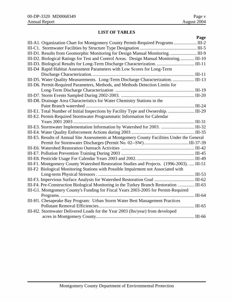
LIST OF TABLES Page III-A1. Organization Chart for Montgomery County Permit-Required Programs .................... III-2 III-C1. Stormwater Facilities by Structure Type Designation .................................................. III-5 III-D1. Results from Geomorphic Monitoring for Design Manual Monitoring. ....................... III-9 III-D2. Biological Ratings for Test and Control Areas. Design Manual Monitoring............. III-10 III-D3. Biological Results for Long-Term Discharge Characterization. ................................. III-11 III-D4 Rapid Habitat Assessment Parameters with Low Scores for Long-Term Discharge Characterization.......................................................................................... III-11 III-D5. Water Quality Measurements. Long-Term Discharge Characterization. ................... III-13 III-D6. Permit-Required Parameters, Methods, and Methods Detection Limits for Long-Term Discharge Characterization ..................................................................... III-19 III-D7. Storm Events Sampled During 2002-2003. ................................................................ III-20 III-D8. Drainage Area Characteristics for Water Chemistry Stations in the Paint Branch watershed ............................................................................................... III-24 III-E1. Total Number of Initial Inspections by Facility Type and Ownership. ....................... III-29 III-E2. Permit-Required Stormwater Programmatic Information for Calendar Years 2001 2003 .......................................................................................................... III-31 III-E3. Stormwater Implementation Information by Watershed for 2003. ............................. III-32 III-E4. Water Quality Enforcement Actions during 2003 ....................................................... III-35 III-E5. Results of Annual Site Assessments at Montgomery County Facilities Under the General
Permit for Stormwater Discharges (Permit No. 02--SW).......................................III-37-39 III-E6. Watershed Restoration Outreach Activities ................................................................ III-42 III-E7. Pollution Prevention Training During 2003 ................................................................ III-45 III-E8. Pesticide Usage For Calendar Years 2003 and 2002. .................................................. III-49 III-F1. Montgomery County Watershed Restoration Studies and Projects. (1996-2003). ..... III-51 III-F2 Biological Monitoring Stations with Possible Impairment not Associated with Long-term Physical Stressors . .................................................................................... III-53 III-F3. Impervious Surface Analysis for Watershed Restoration Goal ................................... III-62 III-F4. Pre-Construction Biological Monitoring in the Turkey Branch Restoration . ............. III-63 III-G1. Montgomery County's Funding for Fiscal Years 2003-2005 for Permit-Required Programs. ..................................................................................................................... III-64 III-H1. Chesapeake Bay Program: Urban Storm Water Best Management Practices Pollutant Removal Efficiencies.................................................................................... III-65 III-H2. Stormwater Delivered Loads for the Year 2003 (lbs/year) from developed acres in Montgomery County...................................................................................... III-66
00-DP-3320 MD0068349 Page vi Annual Report August 2004
Montgomery County Department of Environmental Protection
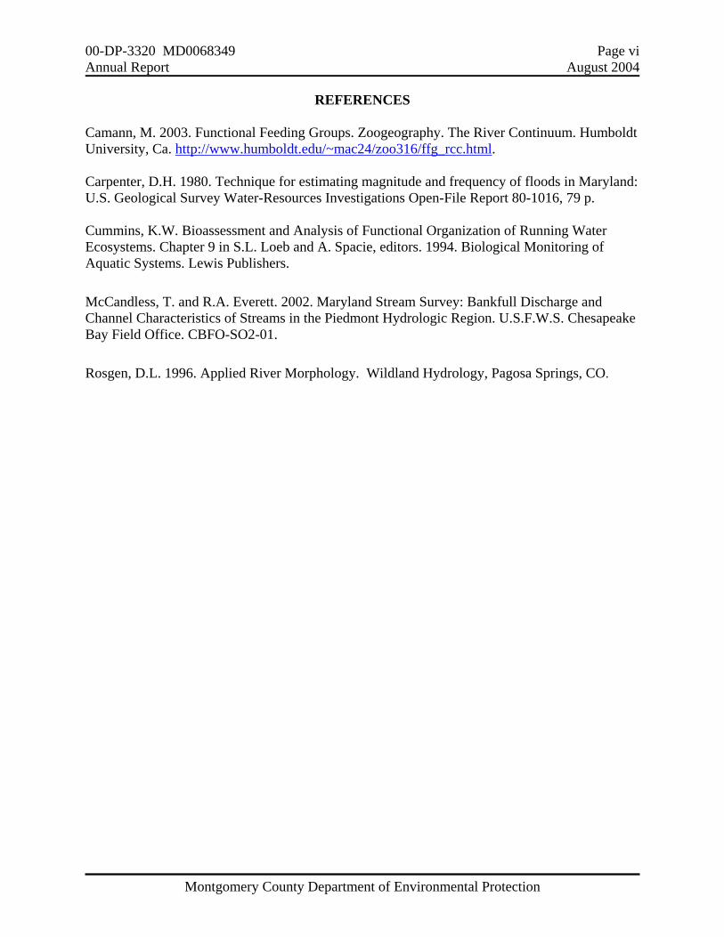
REFERENCES
Camann, M. 2003. Functional Feeding Groups. Zoogeography. The River Continuum. Humboldt University, Ca. http://www.humboldt.edu/~mac24/zoo316/ffg_rcc.html. Carpenter, D.H. 1980. Technique for estimating magnitude and frequency of floods in Maryland: U.S. Geological Survey Water-Resources Investigations Open-File Report 80-1016, 79 p. Cummins, K.W. Bioassessment and Analysis of Functional Organization of Running Water Ecosystems. Chapter 9 in S.L. Loeb and A. Spacie, editors. 1994. Biological Monitoring of Aquatic Systems. Lewis Publishers. McCandless, T. and R.A. Everett. 2002. Maryland Stream Survey: Bankfull Discharge and Channel Characteristics of Streams in the Piedmont Hydrologic Region. U.S.F.W.S. Chesapeake Bay Field Office. CBFO-SO2-01. Rosgen, D.L. 1996. Applied River Morphology. Wildland Hydrology, Pagosa Springs, CO.
00-DP-3320 MD0068349 Page vii Annual Report August 2004
Montgomery County Department of Environmental Protection
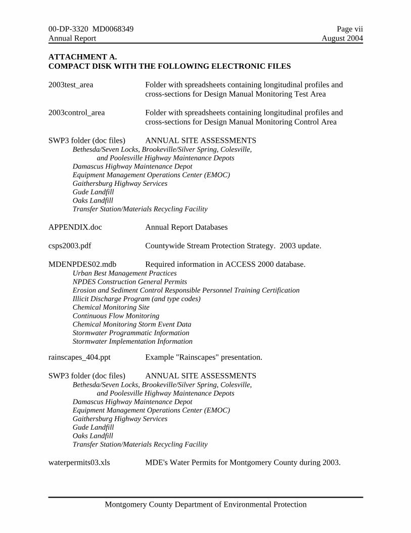
ATTACHMENT A. COMPACT DISK WITH THE FOLLOWING ELECTRONIC FILES 2003test_area Folder with spreadsheets containing longitudinal profiles and cross-sections for Design Manual Monitoring Test Area 2003control_area Folder with spreadsheets containing longitudinal profiles and cross-sections for Design Manual Monitoring Control Area SWP3 folder (doc files) ANNUAL SITE ASSESSMENTS Bethesda/Seven Locks, Brookeville/Silver Spring, Colesville, and Poolesville Highway Maintenance Depots Damascus Highway Maintenance Depot Equipment Management Operations Center (EMOC) Gaithersburg Highway Services Gude Landfill Oaks Landfill Transfer Station/Materials Recycling Facility APPENDIX.doc Annual Report Databases csps2003.pdf Countywide Stream Protection Strategy. 2003 update. MDENPDES02.mdb Required information in ACCESS 2000 database. Urban Best Management Practices NPDES Construction General Permits Erosion and Sediment Control Responsible Personnel Training Certification Illicit Discharge Program (and type codes) Chemical Monitoring Site Continuous Flow Monitoring Chemical Monitoring Storm Event Data Stormwater Programmatic Information Stormwater Implementation Information rainscapes_404.ppt Example "Rainscapes" presentation. SWP3 folder (doc files) ANNUAL SITE ASSESSMENTS Bethesda/Seven Locks, Brookeville/Silver Spring, Colesville, and Poolesville Highway Maintenance Depots Damascus Highway Maintenance Depot Equipment Management Operations Center (EMOC) Gaithersburg Highway Services Gude Landfill Oaks Landfill Transfer Station/Materials Recycling Facility waterpermits03.xls MDE's Water Permits for Montgomery County during 2003.
00-DP-3320 MD0068349 Page viii Annual Report August 2004
Montgomery County Department of Environmental Protection
THIS PAGE INTENTIONALLY LEFT BLANK

00-DP-3320 MD0068349 Page I-1 Annual Report August 2004
Montgomery County Department of Environmental Protection
MONTGOMERY COUNTY MARYLAND NATIONAL POLLUTANT DISCHARGE ELIMINATION SYSTEM
MUNICIPAL SEPARATE STORM SEWER SYSTEM DISCHARGE PERMIT I. BACKGROUND This submission fulfills the requirement for an annual progress report to the Maryland Department of the Environment (MDE) as specified in Part V of Permit Number 00-DP-3320 MD0068349 (the Permit). The five-year Permit term began July 5, 2001, covering stormwater discharges from the municipal separate storm sewer system (MS4) in Montgomery County, Maryland. Significant accomplishments in the County’s stormwater management program during the 2001 calendar year are highlighted in the Overview. The report itself has been organized based on the headings in the Permit’s Section III. to document how specific required elements of the County’s stormwater management program are being implemented. The Montgomery County Department of Environmental Protection (DEP) has primary responsibility for the majority of the requirements of the Permit, including interagency coordination, annual reporting, source identification, discharge characterization, monitoring, stormwater facility inspection and maintenance enforcement, illicit discharge detection and elimination, watershed public outreach, and watershed restoration plans. The Department of Permitting Services (DPS) is responsible for the County’s Stormwater and Sediment and Erosion Control Program. The Department of Public Works and Transportation (DPWT) is responsible for storm drains, road and roadside maintenance, solid waste disposal, and the General Permit for Storm Water Discharges Associated with Industrial Facilities at the County-owned vehicle and road maintenance and solid waste management facilities. The Maryland Department of the Environment (MDE) modified the County's Permit effective January 26, 2004 to add six small localities as co-permittees for coverage under the Phase II of the National Pollutant Discharge Elimination System (NPDES) MS4 Permit Program. There were five municipalities: the Towns of Chevy Chase, Kensington, Poolesville, and Somerset, and Chevy Chase Village; and one special tax district, the Village of Friendship Heights. Details on these localities and existing coverage under the County's NPDES MS4 permit were provided in the September 2003 co-permittee application to MDE. The Annual Report for 2004 will include information specific as to how permit requirements are being met in these six localities. The database format is included in electronic version as Appendix A in Attachment A. This includes the field names, formats, and explanatory information provided by MDE.
00-DP-3320 MD0068349 Page II-1 Annual Report August 2004
Montgomery County Department of Environmental Protection
II. OVERVIEW Source Identification The Permit requires Montgomery County to inventory and map potential pollutant sources and means of conveyance into receiving streams and other water bodies. To comply, the County continues to update and enhance its Geographic Information System (GIS) capabilities for source identification, natural resources mapping, and program tracking. During 2003 into 2004, the DPS made significant progress in updating the subdivision storm drain system electronic database. This update should be completed by the summer of 2005 and will add information on all public and private storm drains built in the County since October 1997. The ongoing effort will also establish a process to add digitized information on new storm drain systems in a routine manner. The comprehensive, geographically-referenced database that will allow access to all state and local permits is still under development. As in past years, the DEP obtained the list of NPDES-permitted municipal and industrial facilities in the County from MDE and created a GIS data layer of their locations. There were a total of 310 sites with NPDES program permits in the County, of which 72 were General Industrial Stormwater Permits and 4 were Municipal Stormwater permits. The County's submission for the MDE Urban Best Management Practices (BMPs) database includes 3,670 records, of which 2,366 represent sites with more than one BMP on the site. The DEP made a significant effort this year to find information from existing paper files for all facilities constructed prior to the County's first NPDES MS4 Permit (1996). The Stormwater Facility Management Program (SWFMP) will move to a new data management system within the next year and hopes to have many of the data deficiencies resolved before the data is moved. Discharge Characterization The Permit requires that "Montgomery County shall contribute to Maryland’s understanding of stormwater runoff and its effect on water resources by conducting a monitoring program." During 2003, the DEP continued its paired outfall and instream integrated water chemistry,
biological, and physical habitat monitoring in the Stewart-April Lane Tributary and Lower Paint Branch Mainstem. Detailed analysis is deferred until post-construction data is available. o From spring 2001 to October 2002, there was an extended drought which resulted in the
lowest flows on record in the Potomac River and other area waterways. In contrast, record high precipitation during 2003 produced record high flows in these same water bodies.
o Twelve baseflow and 11 storm events were monitored. This included stormflow conditions after the President's Day Blizzard in February which dumped more than 24" of snow in the region. During 2002, eight baseflow and six storm events were sampled, although the extended drought prevented achieving the County's goal of once per month storm sampling.
o A comparison of storm water chemistry conditions in the Upper and Lower Paint Branch documented the extent of poor water quality in the Stewart-April Lane tributary. During 1998 and 1999, the concentrations of both Oil and Grease and Total Copper were
00-DP-3320 MD0068349 Page II-2 Annual Report August 2004
Montgomery County Department of Environmental Protection
consistently higher in the Stewart-April Lane tributary than elsewhere. These toxic substances add to the adverse impacts of the uncontrolled stormwater volume into the Stewart-April Lane tributary.
o Biological monitoring results for the Stewart-April Lane tributary showed poor benthic macroinvertebrate and fish resource conditions for 1994, 2001, and 2002. During 2003, no fish were caught during sampling so fish conditions continued to be rated as "poor", but the benthic macroinvertebrate conditions improved to "fair". The biological conditions in the lower Paint Branch mainstem were fair for the benthic community both above and below the Stewart-April Lane Tributary, and "good" for the fish community above but "fair" for the fish community below the tributary. Habitat conditions were good at all three stations, although on the lower end of that ranking for the Stewart-April Lane tributary.
o The composition of the benthic community in the Stewart-April Lane tributary in the Lower Paint Branch were compared to those for a station in Gum Springs in the Upper Paint Branch. Both represent first order streams, but the Stewart-April Lane tributary has a much higher percent imperviousness and no stormwater control compared to Gum Springs. The benthic community in first order headwater streams is dominated by collectors and shredders, which was true for both stations. However, the Stewart-April Lane tributary had a much higher biotic index score indicating a larger number of organic-pollution tolerant taxa.
The first round of required monitoring to assess the State's Stormwater Design Manual was completed during summer 2003. The County is monitoring in the Clarksburg Town Center Tributary (test watershed) and comparing results from the Sopers Branch (control watershed). During 2003, the test watershed experienced rapid development and corresponding land cover changes. Detailed analysis will be presented when more data are available. The baseline cross-section and stream profiles are included with this submission. The protocols being used have been adapted from McCandless and Everett (2002) and include cross section surveys, longitudinal profiles, pebble counts, and sinuosity measurements.
Management Programs The Permit requires that the County maintain specific jurisdiction-wide management programs to control stormwater discharges to the maximum extent practicable. These include stormwater management facility inspection and maintenance, stormwater management permitting and plan review, sediment and erosion control enforcement, illicit discharge identification and elimination, stormwater pollution prevention plans for County-owned industrial facilities, and public outreach. In 2003, the DEP performed 950 initial stormwater facility inspections, of which 684 were at
privately owned facilities and 266 were at publicly owned facilities. These initial inspections identified need for repair at approximately 78% of all structures--about 89% of the aboveground structures and 63% of the belowground structures. In contrast, during 2002, initial inspections identified some sort of repair was needed at 99% of the aboveground structures and 71% of the belowground structures..
The DPS reported that the number of sediment control permits increased slightly from 2002 to
00-DP-3320 MD0068349 Page II-3 Annual Report August 2004
Montgomery County Department of Environmental Protection
2003 as did the total developed acres. However, the amount of land served by stormwater management facilities increased by a greater percentage. This was due to changes in the County Code which removed large lot exemptions for newly subdivided land prior to 2003 and which required previously existing lots to meet current standards if application for a sediment control permit was made on or after July 1, 2003.
During early 2004, the DEP screened a total of 101 outfalls, focusing on older, urban areas, including those located in the Phase 2 municipalities of the Towns of Chevy Chase, Kensington, Somerset, the Village of Friendship Heights, and Chevy Chase Village. Of the 18 outfalls found to have flows, 14 were identified as piped streams with constant flow while four were determined to have dry weather flows. Of these, two showed detergent above detection limit, one showed chlorine above detection limit, and one showed copper above detection limit. Source tracking was unsuccessful at these outfalls because of the many potential contributing sources and the apparent lack of continuous input.
For calendar year 2003, the DEP investigated 193 water quality complaints and 78 hazardous materials incidents. These investigations resulted in the issuance of 37 Enforcement Actions (21 Civil Citations with fines totaling $10,500 and 16 Notices of Violation (NOVs)). The majority of these were improper handling of automotive fluids but there were also a large number for improper handling or improper disposal of cooking grease.
The annual site assessments at the County-owned facilities covered under the General Permit for Stormwater Discharges from Industrial facilities were conducted during spring 2004. These assessments identified staffing changes, site changes, and site activities not included on the existing Stormwater Pollution Prevention Plans, particularly for three of the facilities: Seven Locks, Gaithersburg/Equipment Maintenance Operations Center, and the Silver Spring/Brookeville facilities. The DPWT is following up on recommendations from this year's assessments to update the Stormwater Pollution Prevention Plans, increase employee training for pollution prevention, and implement additional vacuum sweeping to reduce the amount of materials in runoff to each site's stormwater management facilities.
The DEP continued a multimedia approach for environmental outreach and public education, including print, web site, and video, and an extensive calendar of activities on the County's web site. The Watershed Management Division continued its emphasis of hands-on involvement such as stream walks, clean-ups, storm drain stenciling, and tree plantings. During 2003, the DEP expanded ongoing outreach efforts for watershed restoration using Chesapeake Bay Trust funding to support the existing "Rainscapes" program. This program involves residents and resource users in pollution source control, water conservation, and creation of backyard wildlife habitat. Seven workshops were conducted and four sites used to construct demonstration rain gardens.
During 2003, the County Council and County Executive approved a resolution creating the Montgomery County Environmental Policy. The Policy required that all County Agencies and Departments develop an Environmental Action Plan by June 30, 2004 to document existing efforts for environmental protection or improvement and also set goals for the coming year.. Results from implementation of these Environmental Action Plans will be included in future Annual Reports.
00-DP-3320 MD0068349 Page II-4 Annual Report August 2004
Montgomery County Department of Environmental Protection
The DPWT re-initiated its countywide street sweeping program using a one-third cost-share
arrangement with DEP. The DEP support recognized the importance of the County's street sweeping program as a means of reducing solids being carried into its stormwater management facilities and waterways. During 2003, the amount of materials collected was tracked by sweeping route to better evaluate which areas were the "dirtiest" and therefore should be swept first, or more frequently, for greatest cost-effectiveness. The average of 1.09 tons collected per curb mile was about twice that from 1999-2001, but the total amount collected represented less than 10% of the total amount of de-icing materials applied during the previous winter. In general, the areas in the southern, more urbanized parts of the County showed the highest per curb mile collection rate regardless of sweep start date. This finding supports the need to sweep these areas first, to condense sweeping into less than the five months currently allotted, and to consider multiple sweepings in those areas with the greatest amounts of accumulated material.
Watershed Restoration The Permit requires that the County continue its systematic assessment of water quality within all of its watersheds and to maximize water quality benefits in priority subwatersheds using efforts that are definable and the effects of which are measurable. The County program integrates biological monitoring and physical habitat assessments with stormwater retrofit and stream restoration opportunities, water quality discharge law enforcement, and public outreach and involvement. This approach leads to pollution prevention and project construction efforts that are watershed-based and that will provide water quality benefits to the maximum extent practicable. Ongoing and planned watershed assessments and project implementation for FY2005-2010 will
add controls for a total of 4,699 acres and restoration of 42.05 miles of stream. Total cost through December 2003 (including State and Federal cost-share funding) for watershed restoration efforts completed or underway has been $22.9 million dollars. During 2003, the County began a cooperative effort with the COE and the City of Gaithersburg to complete a watershed restoration inventory of the Great Seneca Creek and Muddy Branch watersheds. These areas represent roughly one-third of the total County land area and include drainage from densely-developed areas of Gaithersburg and Germantown.
The DEP continued its countywide screening for biological impairments during 2003. Monitored watersheds were Bennett Creek, Cabin John Creek, Fahrney Branch, Little Bennett Creek, and Rock Creek. Fifteen of the 60 stations (25%) showed impairment from other than physical habitat factors. The one station monitored in Fahrney Branch showed no impairment in the biological community, rated "good" for habitat with an "excellent" fish and "good" benthic community. The majority of the impaired stations lacked pollution-intolerant species and had evidence of fine sediment deposition. Thirteen of these stations are located in the Cabin John Creek and Rock Creek watersheds, six of these 13 in subwatersheds where implementation of stormwater retrofits and stream restoration projects has begun. It is possible that project implementation will also improve water quality and reduce the sources of the existing impairments. Nine stations have

00-DP-3320 MD0068349 Page II-5 Annual Report August 2004
Montgomery County Department of Environmental Protection
been identified for additional investigation through the County’s illicit discharge screening program for 2004.
Turkey Branch in Lower Rock Creek is the subwatershed selected to meet the permit-required watershed restoration goal. Two stream restoration projects in Lower Turkey Branch, covering impacts in 1.7 linear miles of stream, are expected to be completed by December 2004. Two new stormwater management ponds for control to 217 acres and a dry pond retrofit for 189 acres are expected to be constructed during 2005. Pre-construction monitoring was conducted during 2002 and 2003. Post-construction monitoring will take place one year, three years, and then five years after completion of the projects to assess changes in stream condition.
Program Funding The Permit requires that Montgomery County submit each year a fiscal analysis of the capital, operation, and maintenance expenditures necessary for compliance. During FY04, the County spent $12.148 million for these programs and has budgeted $17.303 million for FY05. The significant funding increases in recent years reflect consistent revenues from the Water Quality Protection Charge for stormwater facility maintenance and in Capital Improvement Project (CIP) program funding to implement projects from existing restoration inventories and to begin watershed restoration assessments in the Great Seneca Creek watershed and Muddy Branch, about one-third of the total County land area. Assessment of Controls The permit requires the County to annually submit estimates of expected pollutant load reductions as a result of its proposed management programs. For consistency with the Tributary Strategies process, the County is using the CBP guidelines for removal efficiencies by BMP category. For the year 2003, about 35.1% of all developed lands had some sort of stormwater control with an estimated 8.4% reduction in Total Nitrogen (TN) and a 16.9% reduction in Total Phosphorus (TP) being delivered from developed lands to the County streams and other waterways.

00-DP-3320 MD0068349 Page III-1 Annual Report August 2004
Montgomery County Department of Environmental Protection
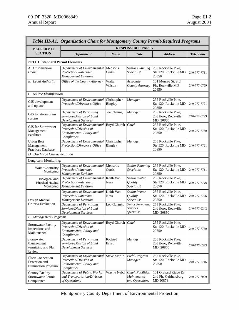
III. STANDARD PERMIT CONDITIONS A. Permit Administration An updated organization chart and contact information is shown in Table III-A1 and enclosed electronically on the CD in Attachment A. The only change from last year was in the Responsible Party for the Illicit Connection Detection and Elimination Program and the Illegal Dumping and Spills Program. B. Legal Authority
The Maryland Department of the Environment (MDE) modified the County's permit effective January 26, 2004 to add six small localities as co-permittees for coverage under the Phase II of the NPDES MS4 Permit Program. There were five municipalities: the Towns of Chevy Chase, Kensington, Poolesville, and Somerset, and Chevy Chase Village; and one special tax district, the Village of Friendship Heights. The County already included these areas within its existing permit activities. The Office of the County Attorney confirmed in the fall of 2002 that all six of these localities are subject to the provisions of Chapter 19 (Erosion and Sediment Control, Stormwater Water Management, Floodplain Management) of the County's Code, but needed stormwater permit coverage under the Phase II rule because of MDE designation. Details on these localities and existing coverage under the County's Permit were provided in the September 2003 co-permittee application to MDE. C. Source Identification C1. Electronic Mapping Base maps have been created and previously submitted to MDE for all required elements under this section. Updates are done routinely on most elements. The most significant outstanding piece is that of the electronic mapping and attribute database for the storm drain system and drainage areas to all major outfalls. The most recent comprehensive submission covered the publicly-owned storm drain systems for which plans were available as of October 1997. During 2003 into 2004, the Department of Permitting Services made significant progress in updating the subdivision storm drain system electronic database. This included filling the position to oversee the GIS mapping and tracking process, developing appropriate attribute tables, writing applications for plan review and extraction, and hiring temporary staff to create the digitized information. The digitizing will continue through 2004, with the intent to have the database update completed by the summer of 2005. This update will add information on all public and private storm drains built in the County since October 1997. The ongoing effort will also establish a process to add digitized information on new storm drain systems in a routine manner. Since August 2003, the DEP mapped an additional 19.6 miles of the County's storm drain system using field reconnaissance. This includes the systems in four of the six co-permittee areas. The Towns of Kensington and Poolesville have initiated storm drain mapping projects
00-DP-3320 MD0068349 Page III-2 Annual Report August 2004
Montgomery County Department of Environmental Protection
Table III-A1. Organization Chart for Montgomery County Permit-Required Programs
RESPONSIBLE PARTY MS4 PERMIT SECTION Department Name Title Address Telephone
Part III. Standard Permit Elements
A. Organization Chart
Department of Environmental Protection/Watershed Management Division
Meosotis Curtis
Senior Planning Specialist
255 Rockville Pike, Ste 120, Rockville MD 20850
240-777-7711
B. Legal Authority Office of the County Attorney Walter Wilson
Associate County Attorney
101 Monroe St. 3rd Flr. Rockville MD 20850
240-777-6759
C. Source Identification
GIS development and update
Department of Environmental Protection/Director's Office
Christopher Bingley
Manager 255 Rockville Pike, Ste 120, Rockville MD 20850
240-777-7721
GIS for storm drain system
Department of Permitting Services/Division of Land Development Services
Joe Cheung Manager 255 Rockville Pike, 2nd floor, Rockville MD 20850
240-777-6299
GIS for Stormwater Management Facilities
Department of Environmental Protection/Division of Environmental Policy and Compliance
Boyd Church Chief 255 Rockville Pike, Ste 120, Rockville MD 20850 240-777-7760
Urban Best Management Practices Database
Department of Environmental Protection/Director's Office
Christopher Bingley
Manager 255 Rockville Pike, Ste 120, Rockville MD 20850
240-777-7721
D. Discharge Characterization
Long-term Monitoring:
Water Chemistry Monitoring
Department of Environmental Protection/Watershed Management Division
Meosotis Curtis
Senior Planning Specialist
255 Rockville Pike, Ste 120, Rockville MD 20850
240-777-7711
Biological and Physical Habitat
Monitoring
Department of Environmental Protection/Watershed Management Division
Keith Van Ness
Senior Water Quality Specialist
255 Rockville Pike, Ste 120, Rockville MD 20850
240-777-7726
Department of Environmental Protection/Watershed Management Division
Keith Van Ness
Senior Water Quality Specialist
255 Rockville Pike, Ste 120, Rockville MD 20850
240-777-7726 Design Manual Criteria Evaluation Department of Permitting
Services/Division of Land Development Services
Leo Galanko Senior Permitting Services Specialist
255 Rockville Pike, 2nd floor, Rockville MD 20850
240-777-6242
E. Management Programs
Stormwater Facility Inspections and Maintenance
Department of Environmental Protection/Division of Environmental Policy and Compliance
Boyd Church Chief 255 Rockville Pike, Ste 120, Rockville MD 20850 240-777-7760
Stormwater Management Permitting and Plan Review
Department of Permitting Services/Division of Land Development Services
Richard Brush
Manager 255 Rockville Pike, 2nd floor, Rockville MD 20850 240-777-6343
Illicit Connection Detection and Elimination Program
Department of Environmental Protection/Division of Environmental Policy and Compliance
Steve Martin Field Program Manager
255 Rockville Pike, Ste 120, Rockville MD 20850 240-777-7746
County Facility Stormwater Permit Compliance
Department of Public Works and Transportation/Division of Operations
Wayne Nebel Chief, Facilities Maintenance and Operations
101 Orchard Ridge Dr. 2nd Flr. Gaithersburg MD 20878
240-777-6099
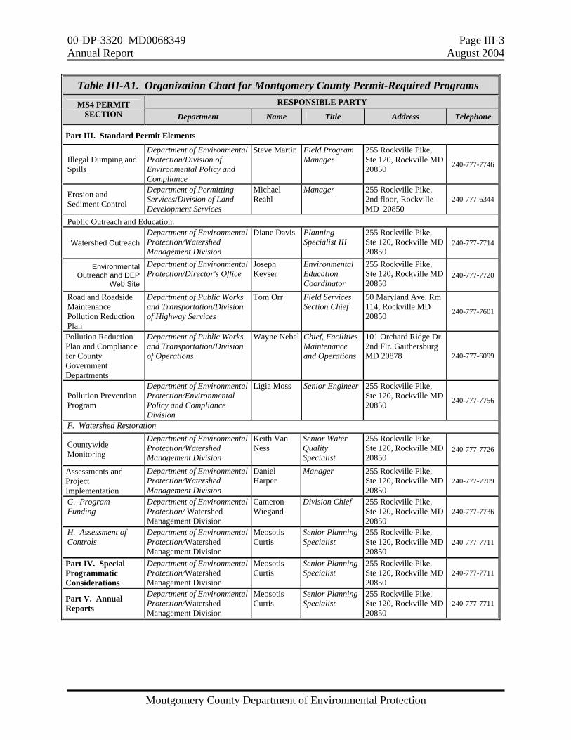
00-DP-3320 MD0068349 Page III-3 Annual Report August 2004
Montgomery County Department of Environmental Protection
Table III-A1. Organization Chart for Montgomery County Permit-Required Programs
RESPONSIBLE PARTY MS4 PERMIT SECTION Department Name Title Address Telephone
Part III. Standard Permit Elements
Illegal Dumping and Spills
Department of Environmental Protection/Division of Environmental Policy and Compliance
Steve Martin Field Program Manager
255 Rockville Pike, Ste 120, Rockville MD 20850 240-777-7746
Erosion and Sediment Control
Department of Permitting Services/Division of Land Development Services
Michael Reahl
Manager 255 Rockville Pike, 2nd floor, Rockville MD 20850
240-777-6344
Public Outreach and Education:
Watershed Outreach Department of Environmental Protection/Watershed Management Division
Diane Davis Planning Specialist III
255 Rockville Pike, Ste 120, Rockville MD 20850
240-777-7714
Environmental Outreach and DEP
Web Site
Department of Environmental Protection/Director's Office
Joseph Keyser
Environmental Education Coordinator
255 Rockville Pike, Ste 120, Rockville MD 20850
240-777-7720
Road and Roadside Maintenance Pollution Reduction Plan
Department of Public Works and Transportation/Division of Highway Services
Tom Orr Field Services Section Chief
50 Maryland Ave. Rm 114, Rockville MD 20850 240-777-7601
Pollution Reduction Plan and Compliance for County Government Departments
Department of Public Works and Transportation/Division of Operations
Wayne Nebel Chief, Facilities Maintenance and Operations
101 Orchard Ridge Dr. 2nd Flr. Gaithersburg MD 20878 240-777-6099
Pollution Prevention Program
Department of Environmental Protection/Environmental Policy and Compliance Division
Ligia Moss Senior Engineer 255 Rockville Pike, Ste 120, Rockville MD 20850 240-777-7756
F. Watershed Restoration
Countywide Monitoring
Department of Environmental Protection/Watershed Management Division
Keith Van Ness
Senior Water Quality Specialist
255 Rockville Pike, Ste 120, Rockville MD 20850
240-777-7726
Assessments and Project Implementation
Department of Environmental Protection/Watershed Management Division
Daniel Harper
Manager 255 Rockville Pike, Ste 120, Rockville MD 20850
240-777-7709
G. Program Funding
Department of Environmental Protection/ Watershed Management Division
Cameron Wiegand
Division Chief 255 Rockville Pike, Ste 120, Rockville MD 20850
240-777-7736
H. Assessment of Controls
Department of Environmental Protection/Watershed Management Division
Meosotis Curtis
Senior Planning Specialist
255 Rockville Pike, Ste 120, Rockville MD 20850
240-777-7711
Part IV. Special Programmatic Considerations
Department of Environmental Protection/Watershed Management Division
Meosotis Curtis
Senior Planning Specialist
255 Rockville Pike, Ste 120, Rockville MD 20850
240-777-7711
Part V. Annual Reports
Department of Environmental Protection/Watershed Management Division
Meosotis Curtis
Senior Planning Specialist
255 Rockville Pike, Ste 120, Rockville MD 20850
240-777-7711
00-DP-3320 MD0068349 Page III-4 Annual Report August 2004
Montgomery County Department of Environmental Protection
within their boundaries using the County's database as a template. These municipalities will provide the County with electronic maps and attributes information when the projects are completed. Expected completion is in late 2004 for the Town of Poolesville and in 2005 for the Town of Kensington. C2. Mapping of New Pollutant Sources The DEP is continuing the development of the comprehensive database that will connect its environmental enforcement database and mapping information on permitted and other potential pollution sources. To date, the emphasis has been on the air quality permits. As in past years, the DEP obtained the list of NPDES-permitted municipal and industrial facilities in the County from MDE and created a GIS data layer of their locations. There were a total of 310 sites with NPDES program permits in the County, of which 72 were General Industrial Stormwater Permits and 4 were municipal stormwater permits. The majority of these sites were in the Potomac watershed--only 10 sites were in the Patuxent River watershed. These sites are included in a spreadsheet on CD in Attachment A. C3. Urban Best Management Practices Database
The database included in electronic format on the CD in Attachment A uses the format required for the MDE’s Urban BMP Database. There are 3,670 records in this database, shown by structure type in Table III-C1. The three structure types with the greatest number are Oil Grit Separator (812), Dry Pond Quantity Control Only (610), and Infiltration Trench Quality Control Only (532). There are 2,366 unique sites represented with multiple facilities on one site sharing the same integer for structure number (STRU_NO) but different non-integer number (e.g. STRU_NOs 1002 and 1002.2 are on the same site). The multiple facilities may be in-series (for sequential treatment) or may be separately located around the site. The DEP made a significant effort this year to find information from existing paper files for all facilities constructed prior to the County's first Permit (1996). The Stormwater Facility Management Program (SWFMP) will move to a new data management system within the next year and hopes to have many of the data deficiencies resolved before the data is moved. There are a few data fields with consistent missing data, including three required for the Urban BMP database. Drainage Area (DA) -- There are 1,463 structures shown in the database that are still missing DA. This is because the DA has not yet been calculated or the facility itself has not yet been confirmed through the inspections program and therefore may not exist. Built Date -- For many of the pre-1996 structures, the date was not recorded and cannot be determined from existing paper files. Any records added from 1996 on will have a built date entered. Land Use -- The data for this field are not complete because of the difference in the land use classification system used by Montgomery County and that used by the Maryland Department of Planning Land Use. The SWFMP will attempt to resolve these differences over the next year.

00-DP-3320 MD0068349 Page III-5 Annual Report August 2004
Montgomery County Department of Environmental Protection
Table III-C1. Stormwater Facilities by Structure Type Designation Structure Type
Designation Description Number
BAYSAV Baysaver 21BR Bioretention, quality control 39BRQN Bioretention, quantity control 1BUFFER Buffer, vegetative strip 1CS Control structure, underground only 10FS Flow splitter 170INF Infiltration trench quality control only 535INFC Infiltration trench and structural chamber system, quality control only 3INFCQN Infiltration trench and structural chamber, quantity and quality control 8INFQN Infiltration trench, quality and quantity control 53INFQNU Infiltration trench, quality and quantity buried, non-surface fed 6INFU Infiltration trench, quality control underground 4INT Interceptor 2LS Level spreader 47PD Pond 29PDIB Pond-infiltration basin, quality control only 17PDIBED Pond-infiltration basin with extended detention 3PDIBQN Pond-infiltration basin, quantity control only 28PDIBQNED Pond-infiltration basin with quantity control and extended detention 7PDQN Pond, quantity control only 610PDQNED Pond with quantity control and extended detention 59PDQNSF Pond-dry, quantity control with sand filter base 17PDWD Pond-wetland only 9PDWDED Pond-wetland and extended detention 15PDWDQN Pond-wetland, quantity control only 39PDWDQNED Pond-wetland with quantity control and extended detention 44PDWT Pond-wet, quality control only 52PDWTED Pond-wet with extended detention 9PDWTQN Pond-wet, quantity control only 134PDWTQNED Pond-wet with quantity control and extended detention 55PP Plunge pool 5PSF Peat sand filter 3SEP Oil-Grit separator 812SEPSF Oil-Grit separator and sand filter 70SF Sand filter 194SFQN Sand filter, quantity control only 20SFU Sand filter, underground 14SP Stone pit 1STC Stormceptor 203STFIL Stormfilter 8UG Underground detention 290UGC Underground chamber system, quantity control only 3UGINF Underground storage with a stone bottom infiltration 3VP Vegetated pool 7VS Vegetated swale 10
Total Number of Structures: 3670

00-DP-3320 MD0068349 Page III-6 Annual Report August 2004
Montgomery County Department of Environmental Protection
D. Discharge Characterization The permit requires that "Montgomery County shall contribute to Maryland’s understanding of stormwater runoff and its effect on water resources by conducting a monitoring program." The locations of the County stations and watersheds in which Permit-required monitoring took place during the year 2003 are shown in Figure III-D1. D1. Outfall and Instream Monitoring During 2002, the County began its paired outfall and instream monitoring in the Stewart-April Lane Tributary and Paint Branch Mainstem. Station locations and details were submitted in previous Annual Report for 2002. Continuous flow readings are being recorded at the outfall and instream sites. The DEP is maintaining continuous flow monitoring on the mainstem of the Upper Good Hope for a long-term record of flow pattern or volume changes. The permit-required tipping bucket rain gauge is located at the Washington Suburban Sanitary Commission (WSSC) Laboratory Facility, only about a mile directly north of the lower Paint Branch monitoring stations. The WSSC is providing laboratory analytical services for all County monitoring programs.
Figure III-D1. Stations and Watersheds for Permit Required Monitoring during 2003.

00-DP-3320 MD0068349 Page III-7 Annual Report August 2004
Montgomery County Department of Environmental Protection
Figures Not to Scale
D2. Stormwater Design Manual Monitoring The Permit requires the County to evaluate the effectiveness of the 2000 Maryland Stormwater Design Manual criteria for stream channel protection. This includes permanently monumented cross-sections, annual comparison surveys, and hydrologic and/or hydraulic model to monitor stream channel changes as a result of development or retrofits in the contributing watershed. The County's selected small watershed is in Little Seneca Creek in the Clarksburg Town Center north and west of Gaithersburg. The results from this test watershed will be compared with those from Sopers Branch within the Little Bennett Regional Park. The Sopers Branch watershed is a control area with stable land cover characteristics. As shown in Figure III-D2, four monitoring stations have been established in each watershed. Details on existing land cover characteristics and station locations for the test and the control watersheds were presented in last year's Annual Report. In 2002, land use in both watersheds was predominantly forest and agricultural fields. During 2003, the test watershed experienced rapid development and corresponding land cover changes.
Figure III-D2. Design Manual Monitoring for Clarksburg Town Center (Little Seneca Test Area) and Sopers Branch Control Area
00-DP-3320 MD0068349 Page III-8 Annual Report August 2004
Montgomery County Department of Environmental Protection
Geomorphic Monitoring Detailed analysis will be presented when more data are available. Data were collected in 2002 and 2003 in the test watershed and in 2003 in the control watershed. The baseline cross-section and stream profiles are included in electronic spreadsheets in Attachment A. The protocols used are adapted from McCandless and Everett (2002) and include cross section surveys, longitudinal profiles, pebble counts, and sinuosity measurements. Results are shown in Table III-D1.
• The cross section surveys involve length and height measurements across a section of the stream. Bankfull height average, bankfull width, flood prone height and flood prone width are determined from the cross section data. There are up to four cross sections within each monitored reach.
• A longitudinal profile is generated for each of the eight monitoring station areas (four
in each watershed). The length of each longitudinal profile is equal to 20 bankfull widths. Slope, maximum pool depth, feature types (riffle, run, pool) and lengths, and pebble counts are recorded for each profile. Diagrams of the longitudinal profiles are also generated.
• One pebble count is conducted per reach to determine substrate size distribution.
Ten transects are established for each pebble count. Ten pebbles are measured across each transect, for a total of 100 pebbles. Stream width, stream feature, and thalweg distance are recorded at each transect. The proportions of pool, riffle, and run are also determined at each transect.
• The sinuosity index was determined with the following equation:
Sinuosity Index = Stream Distance/Valley Distance
The sinuosity index is used in describing the "crookedness" of the stream. Natural streams with steep slopes have low sinuosities (< 1.2), while those with low slopes typically have high sinuosities (> 1.5) (Rosgen, 1996). Piedmont streams, such as those in the Clarksburg area, tend to have moderate slopes. The Stream Distance is the distance from point A to point B measured along the thalweg (primary flow path) of the stream. The Valley Distance is the straight line distance from point A to point B usually measured along the stream bank.

00-DP-3320 MD0068349 Page III-9 Annual Report August 2004
Montgomery County Department of Environmental Protection
Table III-D1. Results from Geomorphic Monitoring for Design Manual Monitoring
(2002-2003) Little Seneca Test
LSLS104 SopersBranch Control
PARAMETER 1 2 3 4 1 2 3 4 HABITAT
Segment Length (m) 56.0 50.1 71.4 132.8 37.6 37.8 81.9 63.9 % Riffle 74 73 54 51 63 68 54 42
% Run 0 11 28 37 28 23 26 51 % Pool 26 16 18 12 9 9 20 7
CHANNEL PARAMETERS Wetted Width (ft) 4.70 5.90 6.30 9.30 3.30 5.40 6.60 6.00
Channel Width (ft) 6.10 7.10 11.10 9.30 7.30 10.80 N/A 11.30Thalweg Depth (ft) 9.65 6.66 13.23 6.50 8.45 6.93 10.15 15.46
Right Bank Height (ft) 5.15 5.94 11.69 5.88 4.79 4.27 8.12 10.98Left Bank Height (ft) 6.52 5.54 10.61 5.48 5.71 5.65 6.68 11.95
Flood Prone Depth (ft) 1.90 2.20 1.68 1.04 1.02 1.34 1.74 Flood Prone Width (ft) 11.20 37.00 13.10 36.60 9.00 11.20 13.30 14.50
Mean Bankfull Depth (ft) 6.65 8.22 8.02 4.68 6.31 6.06 6.79 4.46 Bankfull Width (ft) 9.70 10.30 11.00 22.10 6.50 8.40 8.60 13.10Width/Depth Ratio 1.5 1.3 1.4 4.7 1.0 1.4 1.3 2.9
Entrenchment Ratio 1.2 3.6 1.2 1.7 1.4 1.3 1.5 1.1 ADDITIONAL MEASUREMENTS
% Slope 5.46 5.17 3.89 4.34 6.76 7.17 3.68 3.54 Straight Line Distance (m) 37.60 45.50 49.70 94.80 26.40 31.80 65.50 56.10
Sinuosity Index 1.49 1.10 1.44 1.40 1.42 1.19 1.25 1.14 Modeling the Selected Watershed The Permit requires that a hydrologic and/or hydraulic model be used to analyze the effects of rainfall; discharge rates; stage; and, if necessary, continuous flow on channel geometry. The DPS is requiring the developers within the test watershed to prepare and run a TR-20 model to compare pre-development and post-development runoff. The model requires identification of existing and proposed land uses, impervious area, and stormwater management to predict post-development runoff. Site design and stormwater management plans have been approved for the first phase of the two significant developments proposed for the test watershed. The model runs have been deferred until the remaining phases (currently under review) of the development projects have advanced far enough in the design and approval process that the proposed stormwater management facilities and land uses can be accurately reflected in the model set up. Rainfall and Runoff Monitoring Rain gauge data will be used in evaluating the response of streamflow to rainfall amounts and intensities. One rain gauge was installed midway between both watersheds at the Little Bennett Regional Park Maintenance Yard compound, and began recording on September 24, 2003 at 15:35.
00-DP-3320 MD0068349 Page III-10 Annual Report August 2004
Montgomery County Department of Environmental Protection
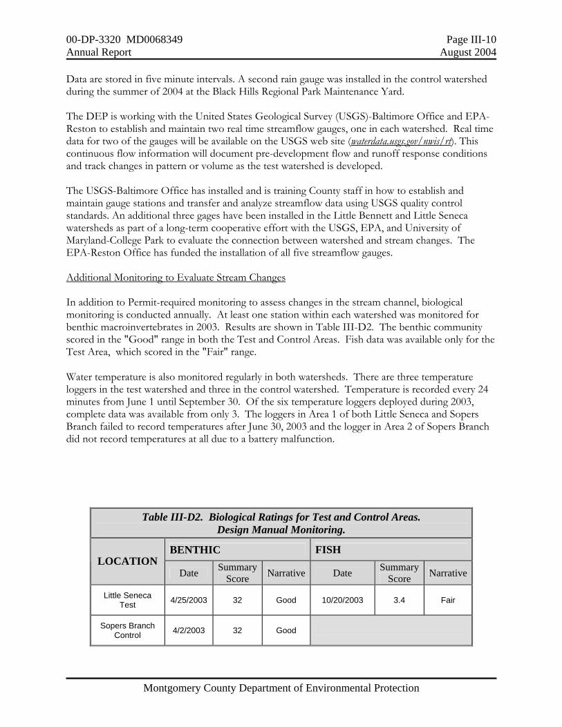
Data are stored in five minute intervals. A second rain gauge was installed in the control watershed during the summer of 2004 at the Black Hills Regional Park Maintenance Yard. The DEP is working with the United States Geological Survey (USGS)-Baltimore Office and EPA-Reston to establish and maintain two real time streamflow gauges, one in each watershed. Real time data for two of the gauges will be available on the USGS web site (waterdata.usgs.gov/nwis/rt). This continuous flow information will document pre-development flow and runoff response conditions and track changes in pattern or volume as the test watershed is developed. The USGS-Baltimore Office has installed and is training County staff in how to establish and maintain gauge stations and transfer and analyze streamflow data using USGS quality control standards. An additional three gages have been installed in the Little Bennett and Little Seneca watersheds as part of a long-term cooperative effort with the USGS, EPA, and University of Maryland-College Park to evaluate the connection between watershed and stream changes. The EPA-Reston Office has funded the installation of all five streamflow gauges. Additional Monitoring to Evaluate Stream Changes In addition to Permit-required monitoring to assess changes in the stream channel, biological monitoring is conducted annually. At least one station within each watershed was monitored for benthic macroinvertebrates in 2003. Results are shown in Table III-D2. The benthic community scored in the "Good" range in both the Test and Control Areas. Fish data was available only for the Test Area, which scored in the "Fair" range. Water temperature is also monitored regularly in both watersheds. There are three temperature loggers in the test watershed and three in the control watershed. Temperature is recorded every 24 minutes from June 1 until September 30. Of the six temperature loggers deployed during 2003, complete data was available from only 3. The loggers in Area 1 of both Little Seneca and Sopers Branch failed to record temperatures after June 30, 2003 and the logger in Area 2 of Sopers Branch did not record temperatures at all due to a battery malfunction.
Table III-D2. Biological Ratings for Test and Control Areas. Design Manual Monitoring.
BENTHIC FISH LOCATION
Date Summary Score Narrative Date Summary
Score Narrative
Little Seneca Test 4/25/2003 32 Good 10/20/2003 3.4 Fair
Sopers Branch Control 4/2/2003 32 Good

00-DP-3320 MD0068349 Page III-11 Annual Report August 2004
Montgomery County Department of Environmental Protection
D3. Long Term Discharge Characterization during 2003
Biological and Physical Habitat Monitoring
To date, DEP has four years of pre-construction data at the Stewart-April Lane tributary station (PBPB104) and two years of data at mainstem lower Paint Branch stations PBPB309B (upstream of the tributary) and PBPB310A (downstream of the tributary). As shown in Table III-D3, this includes fish data for 1995 and benthic macroinvertebrate data for 1996 for PBPB104, and fish and benthic macroinvertebrate data for 2001, 2002, and 2003 for all three stations. Detailed analysis is deferred until after retrofit construction is complete.
Table III-D3. Biological Results for Long-Term Discharge Characterization.
PRPB104 tributary
PBPB309B upstream
PBPB310A downstream YEAR
(Pre-Construction) Fish Benthic Fish Benthic Fish Benthic
1995 1996 2001 2002
2003 (no fish)
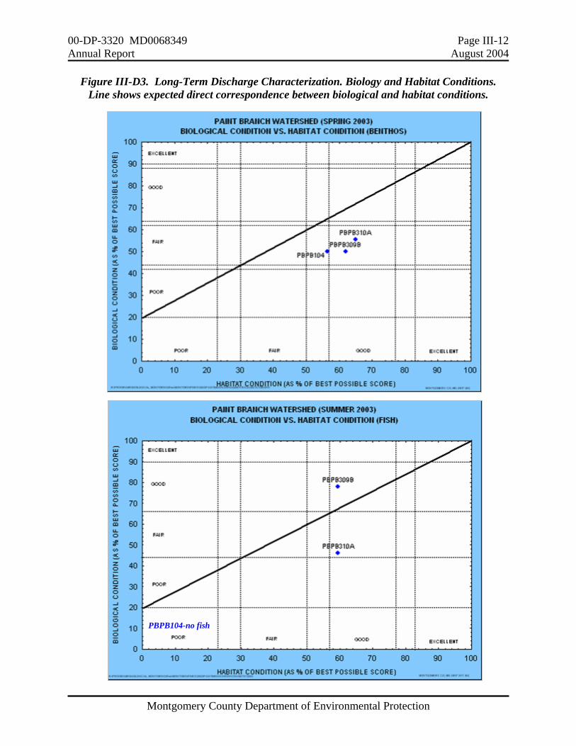
Table III-D4 shows the rapid habitat assessment parameters that scored less than good at each station. The rapid habitat assessment rated overall "Good" at all three sites, although conditions in the tributary were on the lower end of that category. One or both banks showed stability problems at all three stations. Figure III-D3 is a graphical comparison of the habitat ratings with those for the biological community for the 2003 sampling. The benthic macroinvertebrate community was fair for all three sites, while the fish community was good at PBPB309B, fair at PBPB310A, and poor at PBPB104 (no fish).
Table III-D4. Rapid Habitat Assessment Parameters with Low Scores for Long-Term Discharge Characterization.
PBPB104 Stewart April Lane Tributary
• Instream cover (scored 10 out of 20) • Bank Stability (Left Bank scored 4 out of 10 and
Right Bank scored a 3 out of 10).
PBPB309B Paint Branch mainstem upstream of PBPB104 confluence
• Sediment deposition (scored 7 out of 20) • Embeddedness (scored 7 out of 20) • Left Bank Stability (scored 4 out of 10)
PBPB310A Paint Branch mainstem, downstream of PBPB104 confluence
• Instream cover (scored 6 out of 10) • Embeddedness (scored 10 out of 20) • Right Bank stability (scored 3 out of 10)
00-DP-3320 MD0068349 Page III-12 Annual Report August 2004
Montgomery County Department of Environmental Protection
Figure III-D3. Long-Term Discharge Characterization. Biology and Habitat Conditions. Line shows expected direct correspondence between biological and habitat conditions.
PBPB104-no fish
00-DP-3320 MD0068349 Page III-13 Annual Report August 2004
Montgomery County Department of Environmental Protection
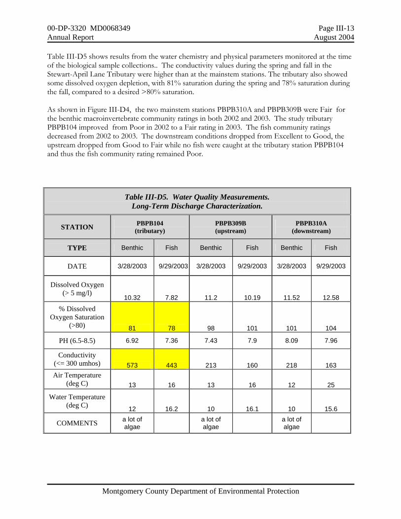
Table III-D5 shows results from the water chemistry and physical parameters monitored at the time of the biological sample collections.. The conductivity values during the spring and fall in the Stewart-April Lane Tributary were higher than at the mainstem stations. The tributary also showed some dissolved oxygen depletion, with 81% saturation during the spring and 78% saturation during the fall, compared to a desired >80% saturation. As shown in Figure III-D4, the two mainstem stations PBPB310A and PBPB309B were Fair for the benthic macroinvertebrate community ratings in both 2002 and 2003. The study tributary PBPB104 improved from Poor in 2002 to a Fair rating in 2003. The fish community ratings decreased from 2002 to 2003. The downstream conditions dropped from Excellent to Good, the upstream dropped from Good to Fair while no fish were caught at the tributary station PBPB104 and thus the fish community rating remained Poor.
Table III-D5. Water Quality Measurements. Long-Term Discharge Characterization.
STATION PBPB104 (tributary)
PBPB309B (upstream)
PBPB310A (downstream)
TYPE Benthic Fish Benthic Fish Benthic Fish
DATE 3/28/2003 9/29/2003 3/28/2003 9/29/2003 3/28/2003 9/29/2003
Dissolved Oxygen (> 5 mg/l)
10.32 7.82 11.2 10.19 11.52 12.58
% Dissolved Oxygen Saturation
(>80) 81 78 98 101 101 104
PH (6.5-8.5) 6.92 7.36 7.43 7.9 8.09 7.96
Conductivity (<= 300 umhos) 573 443 213 160 218 163 Air Temperature
(deg C) 13 16 13 16 12 25
Water Temperature (deg C) 12 16.2 10 16.1 10 15.6
COMMENTS a lot of algae a lot of
algae a lot of algae

00-DP-3320 MD0068349 Page III-14 Annual Report August 2004
Montgomery County Department of Environmental Protection
Figure III-D4. Long-Term Discharge Characterization Comparison of Biological Community Scores
00-DP-3320 MD0068349 Page III-15 Annual Report August 2004
Montgomery County Department of Environmental Protection
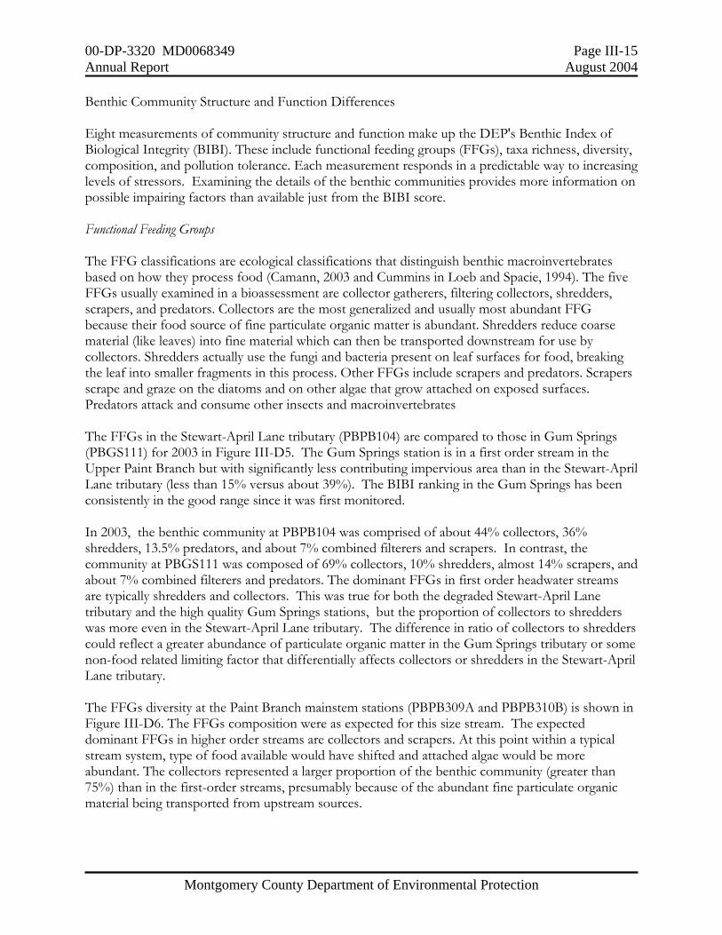
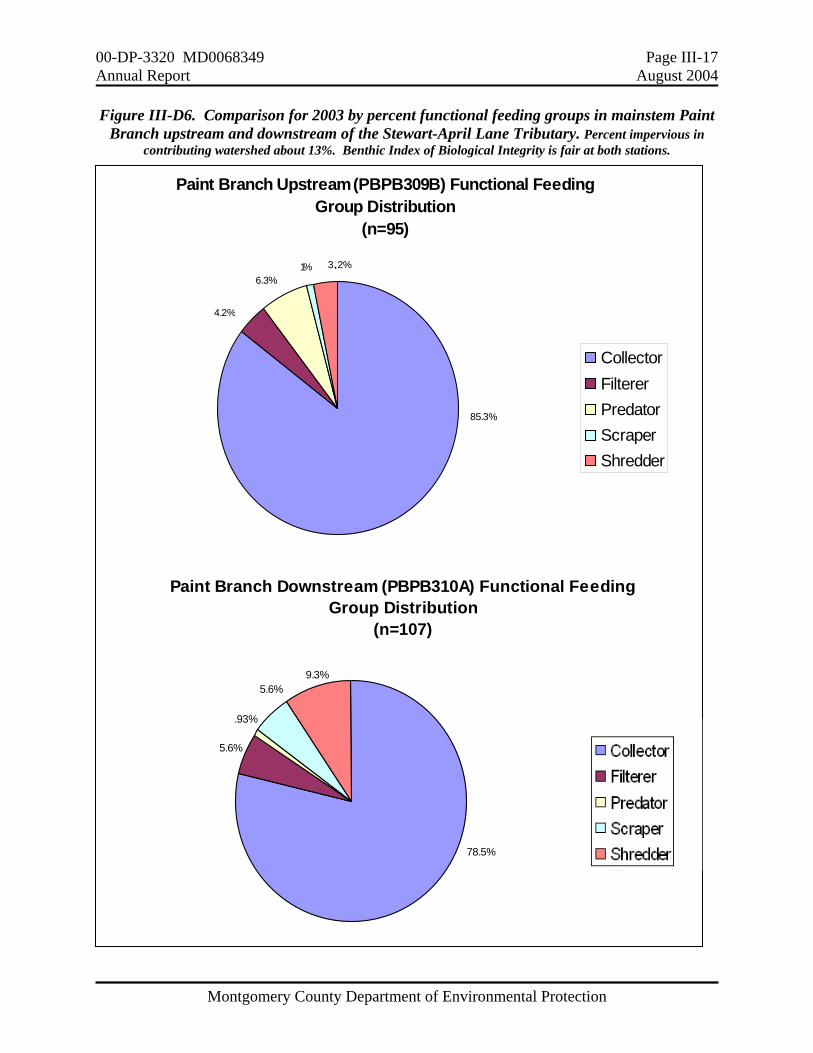
Benthic Community Structure and Function Differences Eight measurements of community structure and function make up the DEP's Benthic Index of Biological Integrity (BIBI). These include functional feeding groups (FFGs), taxa richness, diversity, composition, and pollution tolerance. Each measurement responds in a predictable way to increasing levels of stressors. Examining the details of the benthic communities provides more information on possible impairing factors than available just from the BIBI score. Functional Feeding Groups The FFG classifications are ecological classifications that distinguish benthic macroinvertebrates based on how they process food (Camann, 2003 and Cummins in Loeb and Spacie, 1994). The five FFGs usually examined in a bioassessment are collector gatherers, filtering collectors, shredders, scrapers, and predators. Collectors are the most generalized and usually most abundant FFG because their food source of fine particulate organic matter is abundant. Shredders reduce coarse material (like leaves) into fine material which can then be transported downstream for use by collectors. Shredders actually use the fungi and bacteria present on leaf surfaces for food, breaking the leaf into smaller fragments in this process. Other FFGs include scrapers and predators. Scrapers scrape and graze on the diatoms and on other algae that grow attached on exposed surfaces. Predators attack and consume other insects and macroinvertebrates The FFGs in the Stewart-April Lane tributary (PBPB104) are compared to those in Gum Springs (PBGS111) for 2003 in Figure III-D5. The Gum Springs station is in a first order stream in the Upper Paint Branch but with significantly less contributing impervious area than in the Stewart-April Lane tributary (less than 15% versus about 39%). The BIBI ranking in the Gum Springs has been consistently in the good range since it was first monitored. In 2003, the benthic community at PBPB104 was comprised of about 44% collectors, 36% shredders, 13.5% predators, and about 7% combined filterers and scrapers. In contrast, the community at PBGS111 was composed of 69% collectors, 10% shredders, almost 14% scrapers, and about 7% combined filterers and predators. The dominant FFGs in first order headwater streams are typically shredders and collectors. This was true for both the degraded Stewart-April Lane tributary and the high quality Gum Springs stations, but the proportion of collectors to shredders was more even in the Stewart-April Lane tributary. The difference in ratio of collectors to shredders could reflect a greater abundance of particulate organic matter in the Gum Springs tributary or some non-food related limiting factor that differentially affects collectors or shredders in the Stewart-April Lane tributary. The FFGs diversity at the Paint Branch mainstem stations (PBPB309A and PBPB310B) is shown in Figure III-D6. The FFGs composition were as expected for this size stream. The expected dominant FFGs in higher order streams are collectors and scrapers. At this point within a typical stream system, type of food available would have shifted and attached algae would be more abundant. The collectors represented a larger proportion of the benthic community (greater than 75%) than in the first-order streams, presumably because of the abundant fine particulate organic material being transported from upstream sources.

00-DP-3320 MD0068349 Page III-16 Annual Report August 2004
Montgomery County Department of Environmental Protection
Figure III-D5. Comparison for 2003 by percent functional feeding groups in two first order Paint Branch streams.
Stewart April Lane Tributary: 39% impervious, Benthic Index of Biological Integrity poor. Gum Springs Tributary: less than 15% impervious, Benthic Index of Biological Integrity good.
Stewart April Lane Tributary (PBPB104) Functional Feeding Group Distribution
(n=89)
CollectorFiltererPredatorScraperShredder
43.8%
3.3%
36%
13.5% 3.4%
Gum Springs Tributary (PBGS111)
Functional Feeding Group Distribution (n=154)
CollectorFiltererPredatorScraperShredder
68.9%
9.7%
13.6%
1.9%
5.8%
00-DP-3320 MD0068349 Page III-17 Annual Report August 2004
Montgomery County Department of Environmental Protection
Figure III-D6. Comparison for 2003 by percent functional feeding groups in mainstem Paint Branch upstream and downstream of the Stewart-April Lane Tributary. Percent impervious in
contributing watershed about 13%. Benthic Index of Biological Integrity is fair at both stations.
Paint Branch Downstream (PBPB310A) Functional Feeding Group Distribution
(n=107)
CollectorFiltererPredatorScraperShredder78.5%
9.3%5.6%
.93%
5.6%
Paint Branch Upstream (PBPB309B) Functional Feeding Group Distribution
(n=95)
CollectorFiltererPredatorScraperShredder
85.3%
3.2%6.3%
4.2%
1%
00-DP-3320 MD0068349 Page III-18 Annual Report August 2004
Montgomery County Department of Environmental Protection
Taxa Richness Taxa richness reflects the number of different taxa found at a station, with more taxa showing a more diverse community. The average number of taxa found in the Stewart-April Lane tributary during the four years of monitoring was much less than that at Gum Springs (10 vs. 18 taxa). The 10 taxa found in the tributary were also less than for either mainstem station--12 taxa upstream and 15 downstream. Biotic Index and Pollution Tolerance The biotic index measures the amount of organic pollution tolerant benthic macroinvertebrates in a subsample. The higher the index number, the more pollution tolerant individuals are in the subsample and the more likely the stream will show a Fair or Poor biological condition. The maximum biotic index score is 10. Communities with scores less than 3.31 are considered to have few pollution tolerant individuals, between 3.31 and 6.66 to have moderate numbers of pollution tolerant taxa, and communities with scores greater than 6.66 to have a large percent of the community composed of pollution tolerant individuals. In 2003, the Stewart-April Lane tributary had a biotic index score of 7.21 while the Gum Springs had a biotic index score of 4.23. The higher biotic index score in the Stewart-April Lane tributary is indicative of a high amount of organic pollution tolerant taxa in this tributary. Water Chemistry Table III-D6 lists the parameters, methods, and method detection limits, and indicates the availability of the U.S. Corps of Engineers (COE) pre-construction data for comparison. The COE data will be used along with the Permit-required data to characterize the uncontrolled runoff from the subwatershed and to contrast with post-construction results. The first samples for long-term discharge characterization in the Stewart-April Lane Tributary (outfall) and in Lower Paint Branch mainstem (instream) were taken in May 2002. Flow monitoring, baseflow, and storm event water chemistry data collected during 2002-2003 for the outfall and instream stations are included in the electronic database submitted on the CD in Attachment A. The storm event mean concentrations (EMCs) for 2002 have been recalculated, using storm flow volumes based on updated rating curves. The values submitted for the 2002 Annual Report were based on preliminary information. Continuous flow readings are being recorded at both the outfall and instream sites. The tipping bucket rain gauge is located at the WSSC Laboratory Facility in Silver Spring, only about a mile directly north of the monitoring stations. The WSSC is providing laboratory analytical services for all County monitoring programs.
00-DP-3320 MD0068349 Page III-19 Annual Report August 2004
Montgomery County Department of Environmental Protection
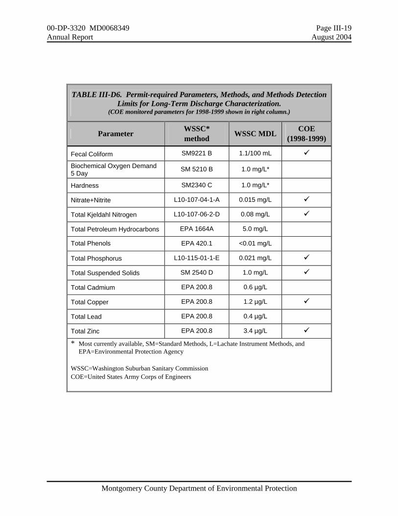
TABLE III-D6. Permit-required Parameters, Methods, and Methods Detection Limits for Long-Term Discharge Characterization.
(COE monitored parameters for 1998-1999 shown in right column.)
Parameter WSSC* method WSSC MDL COE
(1998-1999) Fecal Coliform SM9221 B 1.1/100 mL Biochemical Oxygen Demand 5 Day SM 5210 B 1.0 mg/L* Hardness SM2340 C 1.0 mg/L* Nitrate+Nitrite L10-107-04-1-A 0.015 mg/L Total Kjeldahl Nitrogen L10-107-06-2-D 0.08 mg/L Total Petroleum Hydrocarbons EPA 1664A 5.0 mg/L
Total Phenols EPA 420.1 <0.01 mg/L Total Phosphorus L10-115-01-1-E 0.021 mg/L Total Suspended Solids SM 2540 D 1.0 mg/L Total Cadmium EPA 200.8 0.6 µg/L Total Copper EPA 200.8 1.2 µg/L Total Lead EPA 200.8 0.4 µg/L Total Zinc EPA 200.8 3.4 µg/L
* Most currently available, SM=Standard Methods, L=Lachate Instrument Methods, and EPA=Environmental Protection Agency
WSSC=Washington Suburban Sanitary Commission COE=United States Army Corps of Engineers
00-DP-3320 MD0068349 Page III-20 Annual Report August 2004
Montgomery County Department of Environmental Protection
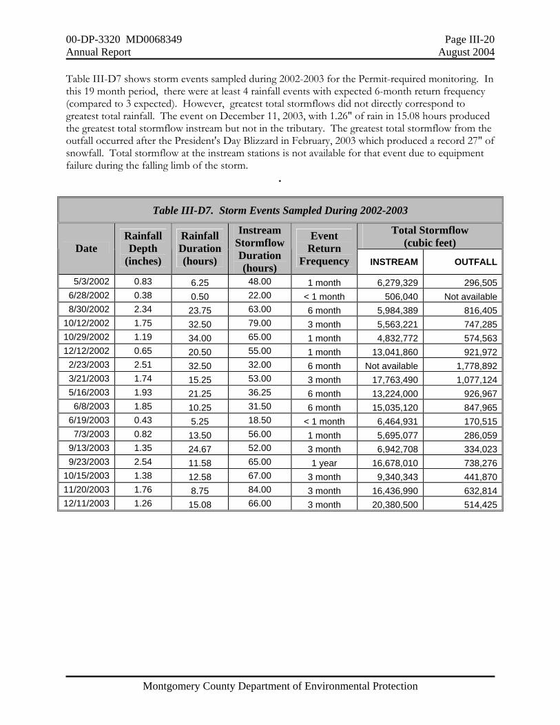
Table III-D7 shows storm events sampled during 2002-2003 for the Permit-required monitoring. In this 19 month period, there were at least 4 rainfall events with expected 6-month return frequency (compared to 3 expected). However, greatest total stormflows did not directly correspond to greatest total rainfall. The event on December 11, 2003, with 1.26" of rain in 15.08 hours produced the greatest total stormflow instream but not in the tributary. The greatest total stormflow from the outfall occurred after the President's Day Blizzard in February, 2003 which produced a record 27" of snowfall. Total stormflow at the instream stations is not available for that event due to equipment failure during the falling limb of the storm.
.
Table III-D7. Storm Events Sampled During 2002-2003
Total Stormflow (cubic feet) Date
Rainfall Depth
(inches)
Rainfall Duration (hours)
Instream Stormflow Duration (hours)
Event Return
Frequency INSTREAM OUTFALL
5/3/2002 0.83 6.25 48.00 1 month 6,279,329 296,5056/28/2002 0.38 0.50 22.00 < 1 month 506,040 Not available8/30/2002 2.34 23.75 63.00 6 month 5,984,389 816,405
10/12/2002 1.75 32.50 79.00 3 month 5,563,221 747,28510/29/2002 1.19 34.00 65.00 1 month 4,832,772 574,56312/12/2002 0.65 20.50 55.00 1 month 13,041,860 921,972
2/23/2003 2.51 32.50 32.00 6 month Not available 1,778,8923/21/2003 1.74 15.25 53.00 3 month 17,763,490 1,077,1245/16/2003 1.93 21.25 36.25 6 month 13,224,000 926,9676/8/2003 1.85 10.25 31.50 6 month 15,035,120 847,965
6/19/2003 0.43 5.25 18.50 < 1 month 6,464,931 170,5157/3/2003 0.82 13.50 56.00 1 month 5,695,077 286,059
9/13/2003 1.35 24.67 52.00 3 month 6,942,708 334,0239/23/2003 2.54 11.58 65.00 1 year 16,678,010 738,276
10/15/2003 1.38 12.58 67.00 3 month 9,340,343 441,87011/20/2003 1.76 8.75 84.00 3 month 16,436,990 632,81412/11/2003 1.26 15.08 66.00 3 month 20,380,500 514,425
00-DP-3320 MD0068349 Page III-21 Annual Report August 2004
Montgomery County Department of Environmental Protection
0.0
1.0
2.0
3.0
4.0
5.0
6.0
7.0
8.0
9.0
10.0
Jan-98 Jul-98 Jan-99 Jul-99 Jan-00 Jul-00 Jan-01 Jul-01 Jan-02 Jul-02 Jan-03 Jul-03
Mon
thly
tota
l pre
cipi
tatio
n (in
ches
)
observednormal
Monthly Total Precipitation (inches) average across MarylandHurricane Floyd
YEAR % normal 1998 97 1999 98 2000 102 2001 83 2002 97 2003 144
Source: Northeast Regional Climate Center
Presidents Day
Blizzard
Rainfall and Runoff Precipitation patterns in Maryland during 1998 through 2003 differed markedly from year to year and from season to season as shown in Figure III-D7. While four of the six years had within 2% of annual total average rainfall, three of those four years (1998, 1999, and 2002) had below normal rainfall during the summer months (June through August). In fact, there was an extended drought from spring 2001 to October 2002, resulting in the lowest flows on record in the Potomac River and other area waterways. In contrast, the record high precipitation during 2003 produced record high flows in these same water bodies. For the Permit-required monitoring, below normal rainfall during most of 2002 did not allow the goal of one successful storm sampling per month or three per season. For the Permit period beginning in July 2001, qualifying rainfall events must be at least one-half hour in duration. One of the rainfall events in any quarter must be of at least 0.3" in quantity in a 24-hour period and at least two in any quarter must be of at least 0.6" in quantity in a 24-hour period. Melting snow may count as a valid storm event provided the equivalent quantity in rain inches meets the above requirements.
Figure III-D7. Monthly Total Precipitation (inches) average across Maryland 1998-2003.
00-DP-3320 MD0068349 Page III-22 Annual Report August 2004
Montgomery County Department of Environmental Protection
Comparing the 24-hour rainfall to peak flow response underscores the importance of antecedent moisture conditions in attempting to predict runoff to rainfall relationships. During 2002-2003, the largest rainfall at the Tech Road gauge occurred on September 23, 2003---Hurricane Isabel. The 2.5 inches measured in 12-hours at the WSSC rain gauge corresponded to a 1-year rain event. The resulting flood at the USGS stream gauge on Northwest Branch at Colesville (roughly 3 miles northwest of the WSSC rain gauge) corresponded to an event between the 5-year and 10-year floods (Carpenter, 1987). There was significant flooding throughout the region during 2003. For example, Figure III-D8 shows that in Seneca Creek at Dawsonville (about 20 miles to the north and west of the lower Paint Branch), there were 9 events during 2003 with instantaneous peak flows exceeding the 2-year peakflow of 2,550 cfs (Carpenter, 1980, shown as ‘flood stage’ on Figure III-D8). The peak event on September 23, 2003 of 6,860 cfs was between a 5-year (5,020 cfs) and a 10-year (7,670 cfs) flood event, compared to the 1-year return frequency for the measured rainfall.
Figure III-D8. Daily Discharge Measurements from June 2002 to June 2004
Source: USGS.
00-DP-3320 MD0068349 Page III-23 Annual Report August 2004
Montgomery County Department of Environmental Protection
The record year of rainfall had a significantly greater number of storms than expected with total precipitation of at least 1” in 24-hour. This amount corresponds to approximately a 2-month frequency rainfall according to the Montgomery County Stormwater Design Manual. As shown in Figure III-D9, there were 18 events at BWI Airport of at least 1" in 24 hours in 2003--compared to the nine that would be expected based on the stormwater design manual. There were no events at BWI (or at any other rain gauge in the region) which corresponded to 2-year or lesser frequency events (>3.2" in 24-hours), although gauged rivers and streams showed many peak flows at lesser return frequencies. It is likely that the significant antecedent soil moisture condition as well as actual rainfall intensity (amount per hour) produced the observed flooding throughout the region which would not be predicted from the 24-hour rainfall amounts.
Figure III-D9. 24-hour rainfall of at least 0.01 inches at BWI for the year 2003. 1.00" in 24 hours is equal to about a 2-month frequency event
(Montgomery County Stormwater Design Manual criteria)
1
2
1
3
1 22
3 2
10
0
0
5
10
15
20
25
Jan Feb Mar Apr May Jun Jul Aug Sep Oct Nov Dec
# of
eve
nts
0.01-1.00 INCH 1.00 INCH OR MORE
1.68"
1.83"
2.55"
1.96"
0.79"
1.63" 1.84"
0.96"
2.4"
3.19"1.5"
1.33"
Number above column=maximum 24-hr rainfall during that month

00-DP-3320 MD0068349 Page III-24 Annual Report August 2004
Montgomery County Department of Environmental Protection
Comparison between Upper Good Hope and Lower Paint Branch The County monitored water chemistry at the outfall of the Colesville Maintenance Depot and downstream in the mainstem of the Upper Good Hope from 1996-2001. Permit-required monitoring in the Stewart-April Lane tributary and the Lower Paint Branch began in 2002. However, during 1998-1999, the COE monitored the Stewart-April Lane tributary to evaluate pre-retrofit construction baseflow and stormflow pollutants. A comparison of existing water quality conditions in the upper and lower Paint Branch will be useful in determining which water chemistry factors could be contributing to differences in the aquatic communities in these areas. The Colesville Maintenance Depot includes approximately 12 acres of mostly impervious area with administrative buildings, parking lots, vehicle maintenance and repair areas, two road salt storage facilities, and a fueling station. In 1998, the County completed site improvements and stormwater retrofits which resulted in significant reductions in stormflow volumes leaving the site. The post-retrofit monitoring also seemed to show lower pollutant means in both baseflow and stormwater discharges from the Depot outfall. Land cover characteristics differ significantly from the upper to lower Paint Branch. Drainage area characteristics for the Stewart-April Lane tributary and the instream stations are shown in Table III-D8. The Upper Good Hope has a high quality aquatic community, including a self-sustaining brown trout population. Its drainage of about 654 acres includes mainly low-density residential land uses and over 60% woods. The Stewart-April Lane Tributary has impervious cover of over 38% and poor aquatic community and habitat conditions.. The drainage to the instream station on the lower Paint Branch mainstem has a moderate percent of impervious (13%) but is dominated by lawns and open (pervious) urban land (57%). Biological and habitat monitoring from 1996-2001 showed good stream resource conditions in the Upper Good Hope both above and below the tributary that receives runoff from the County's Colesville Maintenance Depot. In contrast, the benthic macroinvertebrate community shows some impairment in the lower Paint Branch both above and below the Stewart-April Lane tributary.
Table III-D8. Drainage Areas Characteristics for Water Chemistry Stations in the Paint Branch watershed.
PERCENT Drainage Area Characteristics Impervious Woods Cropland Lawn/
Open Land
Total Acres
Stream miles
Instream: Upper Good Hope Mainstem 7.5 60.9 0 31.6 654 3.14Outfall: Stewart-April Lane Tributary 38.7 21.3 0 40.0 223.4 0.6Instream: Paint Branch Mainstem 13.0 26.6 3.4 57.0 7,734.0 31.5

00-DP-3320 MD0068349 Page III-25 Annual Report August 2004
Montgomery County Department of Environmental Protection
Figure III-D10 shows results for storm event nitrogen monitoring at the Colesville Depot outfall, the Stewart-April Lane Tributary, and the Upper Good Hope mainstem. There were no consistent differences among the concentrations representing the different limbs of the hydrograph (rising, peak, and falling). However, there were differences among the stations. Total nitrogen (sum of Total Kjeldahl Nitrogen and Nitrate+Nitrite) tended to be much higher during storm events in the Stewart-April Lane Tributary than in either the Colesville Depot Tributary or the Upper Paint Branch. This is unexpected based on contributing land uses, which would be expected to show higher nitrogen in runoff from drainage dominated by grassed areas than the drainage that has the highest percentage of impervious areas. Figure III-D11 compares the results for storm event monitoring of Total Phosphorus (TP) and Total Suspended Solids (TSS). TP tended to be lower in the Stewart-April Lane Tributary than at the other two stations, particularly during the spring months. Phosphorus tends to be associated with particles, but there is no clear correlation in the pattern of TP concentrations with those for TSS. The highest TP concentrations at all three stations were observed during the spring months, which could reflect seasonal urban fertilizer use. The highest TSS concentrations were observed during the winter months at the Colesville Depot outfall, which would also coincide with that facility's seasonal salt/sand mixing for road de-icing.
Figure III-D10. Total Nitrogen Concentrations in the Paint Branch. Storm Events 1998-1999.
0.000
1.000
2.000
3.000
4.000
5.000
6.000
Oct-98 Nov-98 Dec-98 Jan-99 Feb-99 Mar-99 Apr-99 May-99 Jun-99 Jul-99 Aug-99
Tota
l Nitr
ogen
(mg/
l)
RISING PEAK FALLINGRISING PEAK FALLINGRISING PEAK FALLING
Stewart-April:Good Hope:
Colesville Depot:
00-DP-3320 MD0068349 Page III-26 Annual Report August 2004
Montgomery County Department of Environmental Protection
-5
45
95
145
195
245
Oct-98 Nov-98 Dec-98 Jan-99 Feb-99 Mar-99 Apr-99 May-99 Jun-99 Jul-99 Aug-99
Tota
l Sus
pend
ed S
olid
s (m
g/l)
RISING PEAK FALLINGRISING PEAK FALLINGRISING PEAK FALLING
Note: Negative values= below method detection limitStewart-April:Good Hope:
Colesville Depot:
-0.060
0.180
0.420
0.660
0.900
Oct-98 Nov-98 Dec-98 Jan-99 Feb-99 Mar-99 Apr-99 May-99 Jun-99 Jul-99 Aug-99
Tota
l Pho
spho
rus
(mg/
l)
Figure III-D11. Total Phosphorus and Total Suspended Solids Concentrations in the Paint Branch. Storm Events 1998-1999.

00-DP-3320 MD0068349 Page III-27 Annual Report August 2004
Montgomery County Department of Environmental Protection
One parameter of concern specifically in the Upper Paint Branch was that of chlorides, as an indicator of seasonal road salt storage and mixing at the Colesville Depot and runoff into the Good Hope. As shown in Figure III-D12, there are very low levels of chlorides and apparently little seasonal road salt influence into the Stewart-April Lane Tributary although there are seasonally high values for the Good Hope. The increased chloride concentration during the winter into spring months was shown in both the Colesville Depot Tributary and in the Good Hope downstream of its confluence. This was a consistent pattern in all monitored years, yet the stream resource conditions above and below this Tributary have remained in the good range since DEP began monitoring. Figure III-D13 shows results for Oil and Grease and Total Copper during storm events. The Oil and Grease sample collection occurs during the rising limb only, that is as a "first flush" event. The concentrations for both these parameters were higher in the Stewart-April Lane Tributary than at the Upper Paint Branch stations. The Total Copper results are similar to those for Total Zinc, the other heavy metal that was monitored at Stewart-April Lane Tributary during 1998-1999. All three of these are toxic to aquatic organisms. Their presence in measurable amounts in stormwater worsen the adverse impacts of uncontrolled stormwater runoff on the Stewart-April Lane Tributary. The large amount of residential and commercial parking areas in the contributing drainage are potential sources of these pollutants. Figure III-D12. Chloride Concentrations in the Paint Branch. Storm Events 1998-1999
0
200
400
600
800
1000
1200
1400
1600
1800
2000
2200
2400
Oct-98 Nov-98 Dec-98 Jan-99 Feb-99 Mar-99 Apr-99 May-99 Jun-99 Jul-99 Aug-99
Chl
orid
es (m
g/l)
RISING PEAK FALLINGRISING PEAK FALLING
Stewart-April:Good Hope:
00-DP-3320 MD0068349 Page III-28 Annual Report August 2004
Montgomery County Department of Environmental Protection
Figure III-D13. Oil and Grease and Total Copper Concentrations in the Paint Branch. Storm Events 1998-1999
-0.005
0.005
0.015
0.025
0.035
0.045
0.055
0.065
Oct-98 Nov-98 Dec-98 Jan-99 Feb-99 Mar-99 Apr-99 May-99 Jun-99 Jul-99 Aug-99
Tot
al C
oppe
r (m
g/l)
RISING PEAK FALLINGRISING PEAK FALLINGRISING PEAK FALLING
Stewart-April:Good Hope:
Colesville Depot:
Note: Negative values= below method detection limit
-10
0
10
20
30
40
50
60
70
80
90
9/30/1998 10/28/1998 11/25/1998 12/23/1998 1/20/1999 2/17/1999 3/17/1999 4/14/1999 5/12/1999 6/9/1999 7/7/1999 8/4/1999 9/1/1999
Oil
and
Gre
ase
(mg/
l)
Stewart-AprilGood HopeColesville Depot

00-DP-3320 MD0068349 Page III-29 Annual Report August 2004
Montgomery County Department of Environmental Protection
E. Management Programs E1. Stormwater Management Program Facility Inspections and Maintenance In 2003, the DEP performed 950 initial inspections, of which 684 were at privately owned facilities and 266 were at publicly owned facilities. Table III-E1 shows the total number of initial inspections by facility type and ownership. The majority of the inspections occurred at three structure types--oil-grit separators (374), infiltration (248), and at dry ponds (172). All of these inspections were conducted by DEP’s contractor under the Stormwater Facility and Inspection Support contract. These initial inspections identified need for repair at approximately 78% of all structures--about 89% of the aboveground structures and 63% of the belowground structures. In contrast, during 2002, initial inspections identified some sort of repair was needed at 99% of the aboveground structures and 71% of the belowground structures. Aboveground facilities include ponds, infiltration, and filtration (bioretention and surface sand filter) structure types. Belowground structures include all structures located physically underground such as oil-grit separators, underground sand filters, and underground storage facilities. As in previous years, the number of belowground inspections for reasons other than routine maintenance was much lower than those for aboveground structures. There were 225 inspections at aboveground facilities and 91 inspections at belowground facilities related to public complaints, to follow-up to 2002 inspection work, and for reconnaissance at facilities being considered for transfer into the DEP's Stormwater Facility Maintenance Program (SWFMP). Maintenance (other than grass cutting and trash removal) is funded through the Water Quality Protection Charge for facilities in the SWFMP. The cost for repairs to 20 ponds during 2003 was $99,397.
Table III-E1. Total Number of Initial Inspections by Facility Type and Ownership
Structure Type Privately Owned
Publicly Owned
Total Number
Dry Pond (Detention) 145 27 172
Filtration 44 3 47 Infiltration 141 107 248 Oil-Grit Separators 244 103 347 Other 16 2 18 Underground Storage 34 2 36 Wet Pond (Retention) 60 22 82
Total Number of Structures 684 266 950
00-DP-3320 MD0068349 Page III-30 Annual Report August 2004
Montgomery County Department of Environmental Protection
Aboveground Facility Inspections The number of initial inspections of aboveground facilities in 2003 was 540. Of these, 379 were at privately owned and 161 were at publicly owned facilities. Of the 540 facilities, 479 needed repairs, seven requiring immediate repairs. Seventy-three facilities required at least one follow-up inspection. The average number of follow-up inspections by DEP’s Inspectors was two per facility; the maximum number was six for one facility. The DEP inspection program provided final inspections at 76 of these facilities, which certifies the facility is up to standard for potential inclusion in the DEP's SWFMP. Seventy-four of these were privately owned and two were publicly owned facilities. Thirteen of these have been accepted for transfer into the DEP program-eight dry ponds and five wet ponds. Belowground Facility Inspections The number of initial inspections of belowground facilities in 2003 was 410--304 at privately owned and 106 at publicly owned facilities. Repairs were made at 258 of these, with 128 facilities having at least one follow-up inspection. The DEP provided final inspections at 382 of these--290 privately owned and 92 publicly owned facilities. Eight of these facilities have been accepted for transfer into the SWFMP--seven oil grit separators and one underground storage structure. Stormwater Management Ordinance and Implementation The permit-required information on stormwater management concept plans approved during the reporting year is shown in Table III-E2 and included in the database on the CD in Attachment A. The number of sediment control permits increased slightly from 2002 to 2003 as did the total developed acres. However, the amount of land served by stormwater management facilities increased by a greater percentage. This was due to changes in the County Code which removed large lot exemptions for newly subdivided land prior to 2003 and which required previously existing lots to meet current standards if application for a sediment control permit was made on or after July 1, 2003. Many of these existing lots were either previously exempt from stormwater management or had previously been granted waivers. New houses are being constructed on a large number of either infill lots or lots in which the existing house will be demolished and replaced by a new house in Montgomery County. Since houses already exist on surrounding lots and infrastructure is already in place, onsite stormwater management may be impractical for smaller lots. Much of the time, the concern is not how to treat or infiltrate runoff but how to convey it safely away from neighboring properties. In these cases, the previous exemption has been verified and the stormwater management requirement has been satisfied through fee payment. During 2003, there were 69 such cases on small, existing residential lots that were created prior to enactment of the first stormwater management laws. The majority of collected stormwater management waiver fee dollars pertain to waivers of channel protection volume requirements for commercial redevelopment projects. The MDE does not require channel protection volume for redevelopment. Montgomery County does. Therefore, if the County waives a redevelopment project of channel protection volume requirements it is not waiving the project of any state mandated stormwater management controls. Water quality requirements are not waived.
00-DP-3320 MD0068349 Page III-31 Annual Report August 2004
Montgomery County Department of Environmental Protection
Table III-E2. Permit-required Stormwater Programmatic Information for Calendar Years 2001 - 2003.
YEAR PERMIT CONDITION 2001 2002 2003
Number of Sediment Control Permits Issued 886 890 912
Total Number of New Preliminary Plans Received, including those that are exempt or for which full or partial waivers were granted
231 190 239
Redevelopment Projects 35 26 28
Projects Exempt from Stormwater Management Requirements 59 27 0
Number of New Projects Which Received Full or Partial Waivers of Two-Year Stormwater Management Requirements
52 37 0
Number of New Projects Which Received Waivers of Channel Protection Volume Storage Requirements
0 5 3
Number of New Projects Which Received Waivers of Quality Management Requirements 31 40 9
Number of Redevelopment Projects Which Received Full or Partial Waivers of Two-Year Stormwater Management Requirements
23 8 0
Number of Redevelopment Projects Which Received Waivers of Channel Protection Volume Storage Requirements
0 7 2
Number of Redevelopment Projects Which Received Waivers of Water Quality Management Requirements
10 4 0
Waiver Fees (Required Where Waivers Are Granted. Collected at the Time Building Permits Are Requested)
$1,183,587 $1,200,484 $910,213
Acres Developed (Based on Issued Sediment Control Permits) 2,125 1,390 1,466
Acres Served by Stormwater Management Facilities (Based on Approved Stormwater Facilities which are included in issued Sediment Control Permits)
1,256 1,122 1,382
00-DP-3320 MD0068349 Page III-32 Annual Report August 2004
Montgomery County Department of Environmental Protection
Table III-E3 compares BMPs approved and implemented in 2003 by major County watersheds. This information is included in the database on the CD in Attachment A. During 2003, the number of BMPs continued to increase in the Potomac watershed. The number also increased in the Monocacy watershed and remained about the same in the Patuxent and Anacostia watersheds. Individual BMPs may be part of a treatment train, where runoff is initially treated by a filtration facility and then discharged into a pond for additional treatment. As shown in Figure III-E1, filtration practices remained the largest type of BMP from 2001-2003. There was also a significant increase in the number of non-structural practices over this three-year period--from none implemented in 2001 to 98 in 2003. Non-structural practices are stormwater runoff treatment techniques that use natural measures to reduce pollution levels, do not require extensive construction efforts and that may promote pollutant reduction by elimination of pollutant sources. There may be multiple uses or implementations of non-structural techniques within one project. Examples include rooftop runoff disconnection and drainage to vegetated buffers or grassed swales.
Notes:
1. For This Report CPV Means either Two Year Stormwater Management or One Year Extended Detention depending on when the stormwater management concept was approved.
2. “Other” Facilities Typically Include Those Not Approved By MDE as Meeting Full Water Quality Requirements
Table III-E3. Stormwater Implementation Information by Watershed for 2003.
BMP TYPE POTOMAC ANACOSTIA MONOCACY PATUXENT Pond 0 0 1 1 Wetland 7 1 0 0 Infiltration 12 2 1 5 Filtration 90 24 3 1 Open Channel 0 0 0 0 Other 30 6 2 2 NonStructural 37 15 3 3 CPV_FAC (Channel Protection) 40 8 2 1
QP10_FAC (10-year discharge) 0 0 0 0
FLOWSPLITTERS 32 12 0 0
TOTAL 248 68 12 13
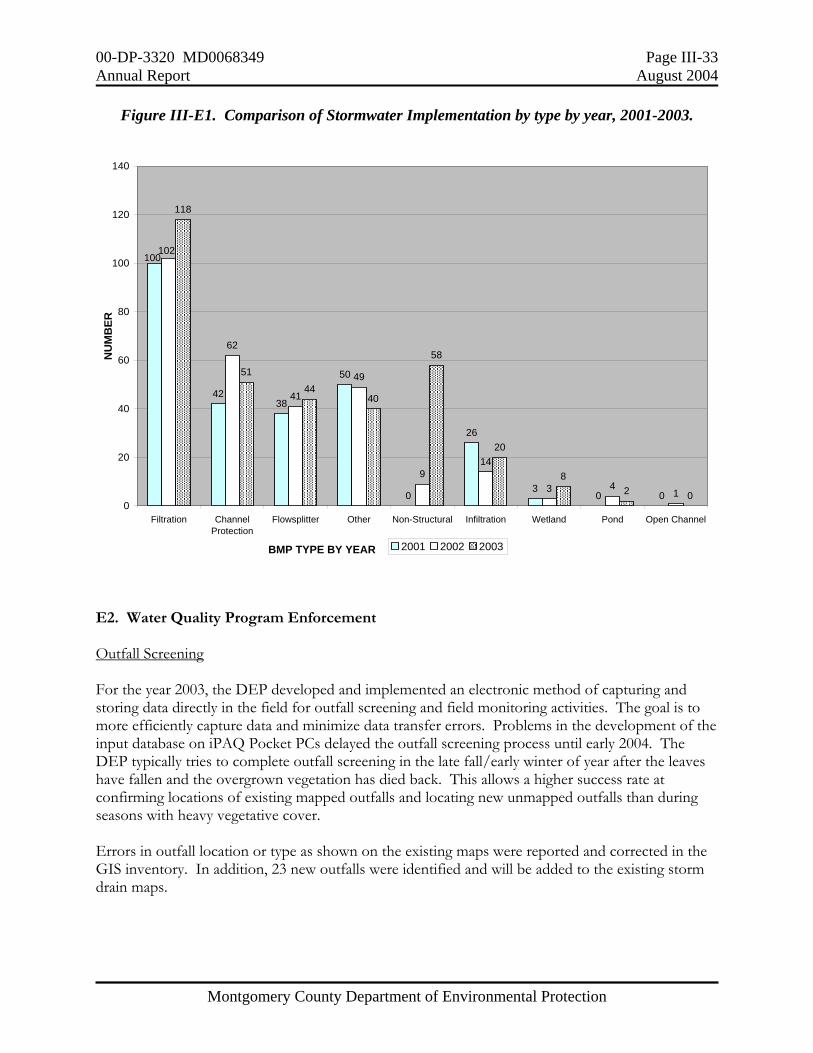
00-DP-3320 MD0068349 Page III-33 Annual Report August 2004
Montgomery County Department of Environmental Protection
Figure III-E1. Comparison of Stormwater Implementation by type by year, 2001-2003.
E2. Water Quality Program Enforcement Outfall Screening
For the year 2003, the DEP developed and implemented an electronic method of capturing and storing data directly in the field for outfall screening and field monitoring activities. The goal is to more efficiently capture data and minimize data transfer errors. Problems in the development of the input database on iPAQ Pocket PCs delayed the outfall screening process until early 2004. The DEP typically tries to complete outfall screening in the late fall/early winter of year after the leaves have fallen and the overgrown vegetation has died back. This allows a higher success rate at confirming locations of existing mapped outfalls and locating new unmapped outfalls than during seasons with heavy vegetative cover. Errors in outfall location or type as shown on the existing maps were reported and corrected in the GIS inventory. In addition, 23 new outfalls were identified and will be added to the existing storm drain maps.
4238
50
0
26
30 0
62
41
49
914
3 41
118
51
4440
58
20
82 0
100102
0
20
40
60
80
100
120
140
Filtration ChannelProtection
Flowsplitter Other Non-Structural Infiltration Wetland Pond Open Channel
BMP TYPE BY YEAR
NU
MB
ER
2001 2002 2003

00-DP-3320 MD0068349 Page III-34 Annual Report August 2004
Montgomery County Department of Environmental Protection
During early 2004, the DEP screened a total of 101 outfalls of which 18 had dry weather flows. The focus was on the older, urban areas, targeting outfalls that are located in the Phase 2 municipalities of the Towns of Chevy Chase, Kensington, Somerset, the Village of Friendship Heights, and Chevy Chase Village. In addition, the DEP screened outfalls in the Montgomery Mall and Rock Spring Industrial Center and the White Flint Mall area based on existing heavy commercial uses and prior experiences with water quality complaints. The DEP also conducted follow up screening at nine outfalls (two in the Hawlings River watershed and seven in the Muddy Branch watershed) that drained to reaches identified as having biological impairment by other than just physical habitat factors. Results from the outfall screening are included in the database on CD in Attachment A. The DEP has not completed drainage area delineations to outfalls not associated with stormwater management facilities. It is anticipated that this information will be included in next year's annual submission. Of the 18 outfalls found to have flows, 14 were identified as piped streams with constant flow while four were determined to have dry weather flows. Of the four determined to have dry weather flows, two showed detergent above detection limit, one showed chlorine above detection limit, and one showed copper above detection limit. Subsequent source tracking was unsuccessful at these outfalls because of the many potential contributing sources and the apparent lack of continuous input. Additional field investigations at these outfalls will not be conducted until their next scheduled round of screening or if water quality incidents are reported or observed. For the year 2004, the DEP will continue its focus on the older, urban areas, targeting outfalls and will include the seven reaches identified as impaired by other than physical habitat factors through the countywide monitoring. These are listed in Section III-F1.
Water Quality Investigations during 2003 For calendar year 2003, the DEP Division of Environmental Policy and Compliance (DEPC) investigated 193 water quality complaints and 78 hazardous materials incidents. Specific information is shown in Table III-E4. These resulted in the issuance of 37 Enforcement Actions (21 Civil Citations with fines totaling $10,500 and 16 Notices of Violation (NOVs)). The majority of these were improper handling of automotive fluids but there were also a large number associated for improper handling or improper disposal of cooking grease.
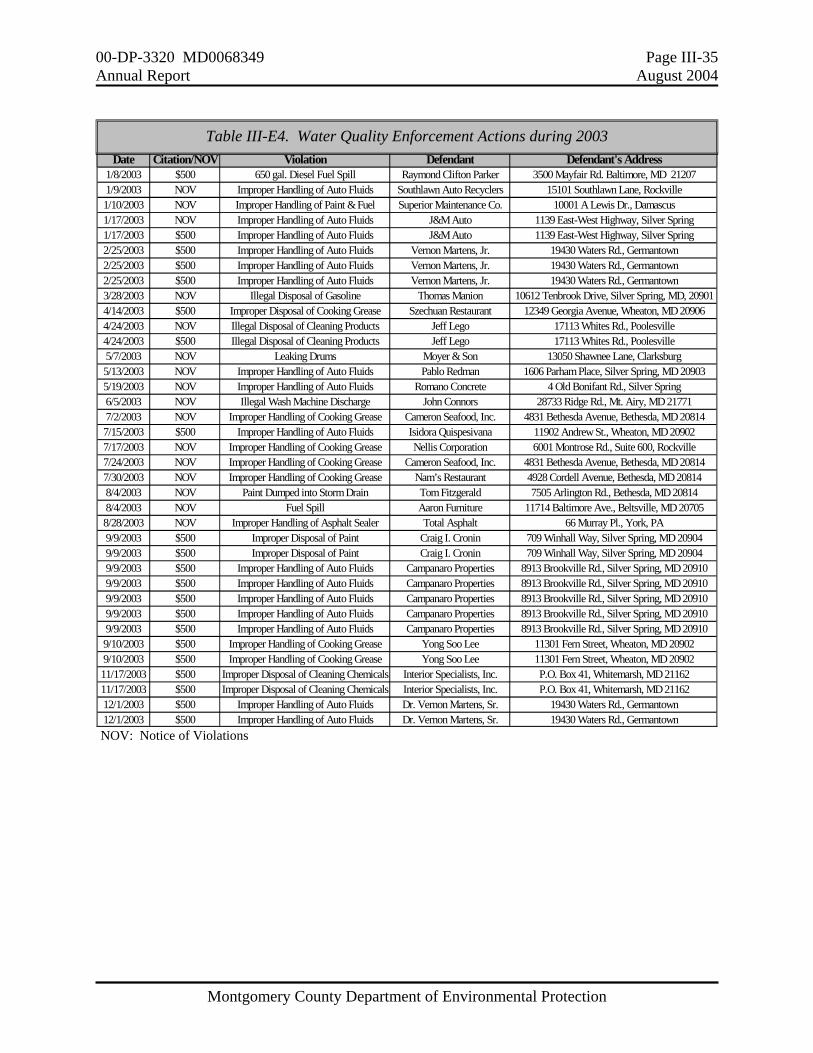
00-DP-3320 MD0068349 Page III-35 Annual Report August 2004
Montgomery County Department of Environmental Protection
.
NOV: Notice of Violations
Date Citation/NOV Violation Defendant Defendant's Address1/8/2003 $500 650 gal. Diesel Fuel Spill Raymond Clifton Parker 3500 Mayfair Rd. Baltimore, MD 212071/9/2003 NOV Improper Handling of Auto Fluids Southlawn Auto Recyclers 15101 Southlawn Lane, Rockville1/10/2003 NOV Improper Handling of Paint & Fuel Superior Maintenance Co. 10001 A Lewis Dr., Damascus1/17/2003 NOV Improper Handling of Auto Fluids J&M Auto 1139 East-West Highway, Silver Spring1/17/2003 $500 Improper Handling of Auto Fluids J&M Auto 1139 East-West Highway, Silver Spring2/25/2003 $500 Improper Handling of Auto Fluids Vernon Martens, Jr. 19430 Waters Rd., Germantown2/25/2003 $500 Improper Handling of Auto Fluids Vernon Martens, Jr. 19430 Waters Rd., Germantown2/25/2003 $500 Improper Handling of Auto Fluids Vernon Martens, Jr. 19430 Waters Rd., Germantown3/28/2003 NOV Illegal Disposal of Gasoline Thomas Manion 10612 Tenbrook Drive, Silver Spring, MD, 209014/14/2003 $500 Improper Disposal of Cooking Grease Szechuan Restaurant 12349 Georgia Avenue, Wheaton, MD 209064/24/2003 NOV Illegal Disposal of Cleaning Products Jeff Lego 17113 Whites Rd., Poolesville4/24/2003 $500 Illegal Disposal of Cleaning Products Jeff Lego 17113 Whites Rd., Poolesville5/7/2003 NOV Leaking Drums Moyer & Son 13050 Shawnee Lane, Clarksburg5/13/2003 NOV Improper Handling of Auto Fluids Pablo Redman 1606 Parham Place, Silver Spring, MD 209035/19/2003 NOV Improper Handling of Auto Fluids Romano Concrete 4 Old Bonifant Rd., Silver Spring6/5/2003 NOV Illegal Wash Machine Discharge John Connors 28733 Ridge Rd., Mt. Airy, MD 217717/2/2003 NOV Improper Handling of Cooking Grease Cameron Seafood, Inc. 4831 Bethesda Avenue, Bethesda, MD 208147/15/2003 $500 Improper Handling of Auto Fluids Isidora Quispesivana 11902 Andrew St., Wheaton, MD 209027/17/2003 NOV Improper Handling of Cooking Grease Nellis Corporation 6001 Montrose Rd., Suite 600, Rockville7/24/2003 NOV Improper Handling of Cooking Grease Cameron Seafood, Inc. 4831 Bethesda Avenue, Bethesda, MD 208147/30/2003 NOV Improper Handling of Cooking Grease Nam’s Restaurant 4928 Cordell Avenue, Bethesda, MD 208148/4/2003 NOV Paint Dumped into Storm Drain Tom Fitzgerald 7505 Arlington Rd., Bethesda, MD 208148/4/2003 NOV Fuel Spill Aaron Furniture 11714 Baltimore Ave., Beltsville, MD 207058/28/2003 NOV Improper Handling of Asphalt Sealer Total Asphalt 66 Murray Pl., York, PA9/9/2003 $500 Improper Disposal of Paint Craig I. Cronin 709 Winhall Way, Silver Spring, MD 209049/9/2003 $500 Improper Disposal of Paint Craig I. Cronin 709 Winhall Way, Silver Spring, MD 209049/9/2003 $500 Improper Handling of Auto Fluids Campanaro Properties 8913 Brookville Rd., Silver Spring, MD 209109/9/2003 $500 Improper Handling of Auto Fluids Campanaro Properties 8913 Brookville Rd., Silver Spring, MD 209109/9/2003 $500 Improper Handling of Auto Fluids Campanaro Properties 8913 Brookville Rd., Silver Spring, MD 209109/9/2003 $500 Improper Handling of Auto Fluids Campanaro Properties 8913 Brookville Rd., Silver Spring, MD 209109/9/2003 $500 Improper Handling of Auto Fluids Campanaro Properties 8913 Brookville Rd., Silver Spring, MD 209109/10/2003 $500 Improper Handling of Cooking Grease Yong Soo Lee 11301 Fern Street, Wheaton, MD 209029/10/2003 $500 Improper Handling of Cooking Grease Yong Soo Lee 11301 Fern Street, Wheaton, MD 2090211/17/2003 $500 Improper Disposal of Cleaning Chemicals Interior Specialists, Inc. P.O. Box 41, Whitemarsh, MD 2116211/17/2003 $500 Improper Disposal of Cleaning Chemicals Interior Specialists, Inc. P.O. Box 41, Whitemarsh, MD 2116212/1/2003 $500 Improper Handling of Auto Fluids Dr. Vernon Martens, Sr. 19430 Waters Rd., Germantown12/1/2003 $500 Improper Handling of Auto Fluids Dr. Vernon Martens, Sr. 19430 Waters Rd., Germantown
Table III-E4. Water Quality Enforcement Actions during 2003
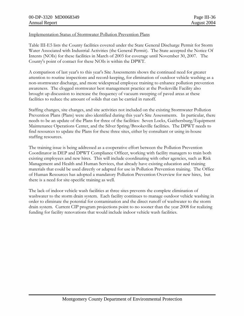
00-DP-3320 MD0068349 Page III-36 Annual Report August 2004
Montgomery County Department of Environmental Protection
Implementation Status of Stormwater Pollution Prevention Plans Table III-E5 lists the County facilities covered under the State General Discharge Permit for Storm Water Associated with Industrial Activities (the General Permit). The State accepted the Notice Of Intents (NOIs) for these facilities in March of 2003 for coverage until November 30, 2007. The County's point of contact for these NOIs is within the DPWT. A comparison of last year's to this year's Site Assessments shows the continued need for greater attention to routine inspections and record-keeping, for elimination of outdoor vehicle washing as a non-stormwater discharge, and more widespread employee training to enhance pollution prevention awareness. The clogged stormwater best management practice at the Poolesville Facility also brought up discussion to increase the frequency of vacuum sweeping of paved areas at these facilities to reduce the amount of solids that can be carried in runoff. Staffing changes, site changes, and site activities not included on the existing Stormwater Pollution Prevention Plans (Plans) were also identified during this year's Site Assessments. In particular, there needs to be an update of the Plans for three of the facilities: Seven Locks, Gaithersburg/Equipment Maintenance Operations Center, and the Silver Spring/Brookeville facilities. The DPWT needs to find resources to update the Plans for these three sites, either by consultant or using in-house staffing resources. The training issue is being addressed as a cooperative effort between the Pollution Prevention Coordinator in DEP and DPWT Compliance Officer, working with facility managers to train both existing employees and new hires. This will include coordinating with other agencies, such as Risk Management and Health and Human Services, that already have existing education and training materials that could be used directly or adapted for use in Pollution Prevention training. The Office of Human Resources has adopted a mandatory Pollution Prevention Overview for new hires, but there is a need for site-specific training as well. The lack of indoor vehicle wash facilities at three sites prevents the complete elimination of washwater to the storm drain system. Each facility continues to manage outdoor vehicle washing in order to eliminate the potential for contamination and the direct runoff of washwater to the storm drain system. Current CIP program projections point to no sooner than the year 2008 for realizing funding for facility renovations that would include indoor vehicle wash facilities.

00-DP-3320 MD0068349 Page III-37 Annual Report August 2004
Montgomery County Department of Environmental Protection
TABLE III-E5. Results of Annual Site Assessments at Montgomery County Facilities Under
the General Permit for Stormwater Discharges (Permit No. 02--SW). FACILITY SUMMARY 2003 ASSESSMENT 2004
Colesville Highway Maintenance Depot Anacostia-Paint Branch; 12 acres
1. Maintains good condition. 2. Need to eliminate any outside vehicle washing because of additional permit required. 3. Need for routine sweeping of outside areas to reduce grit and other solids that could get into storm water best management practices (BMPs). 4. Last training occurred in October 2001; two staff participated.
1. Depot is well maintained and in good condition. 2. Additional attention needed regarding sweeping the yard and general maintenance clean-up during and after milling operations. 3. Need to eliminate any outside vehicle washing because of additional permit required. 4. Storage bins outside need to have a containment devises placed out front. 5. Pollution Prevention Team needs to be updated to identify responsible parties 6 Routine pollution prevention training needs to be offered.
Damascus Highway Maintenance Depot Potomac-Great Seneca Creek; 1.4 acres
1. Public "drop-off" area not yet added to routine inspections. Needs to be swept frequently to minimize blowing trash and monitored frequently for potential spills or leaking material. 2. No provisions for indoor vehicle washing at site. Outdoor vehicle washing requires permit. 3. Last training occurred in October 2001; two staff participated.
1. Public drop-off area has been added to routine inspections, and is hand swept weekly. 2. Salt domes are well maintained and regular sweeping general area is done. 3. No provisions for indoor vehicle washing at site. Outdoor vehicle washing requires permit. 4. Spill prevention and containment BMPs are evident in service bays. 5. Routine pollution prevention training needs to be offered. 6. Pollution Prevention Team needs to be updated to identify responsible parties
Gaithersburg Highway Maintenance Depots, Equipment Maintenance Operations Center & Gaithersburg/Rockville Transit Services Potomac-Rock Creek; 26 acres
1. Significant contractor fuel spill in December 2002 was addressed rapidly and effectively. 2. Need to cover all outside storage areas and remove potential contaminating products as soon as possible. 3. Need to maintain routine trash removal, area cleaning, and sweeping of paved areas. 4. Pollution Prevention and Environmental Management training presented in March 2002. About 60 staff attended.
1. Site plan needs to be updated upon completion of Compressed Natural Gas site at EMOC. 2. Need to cover or eliminate outdoor storage areas and maintain inventory control of products on site. 3. Need to maintain routine trash removal, area cleaning, and sweeping of paved areas. 4. Need to establish emergency procedures for fuel transfer monitoring and spills. 5. Need to schedule more frequent inspections for routine maintenance of sediment traps, particularly those for steam-cleaning operation and for temporary asphalt grinding/recycling area 6. Need to secure Gaithersburg lot to prevent out- of- hours dumping. 7. Routine pollution prevention training needs to be offered.
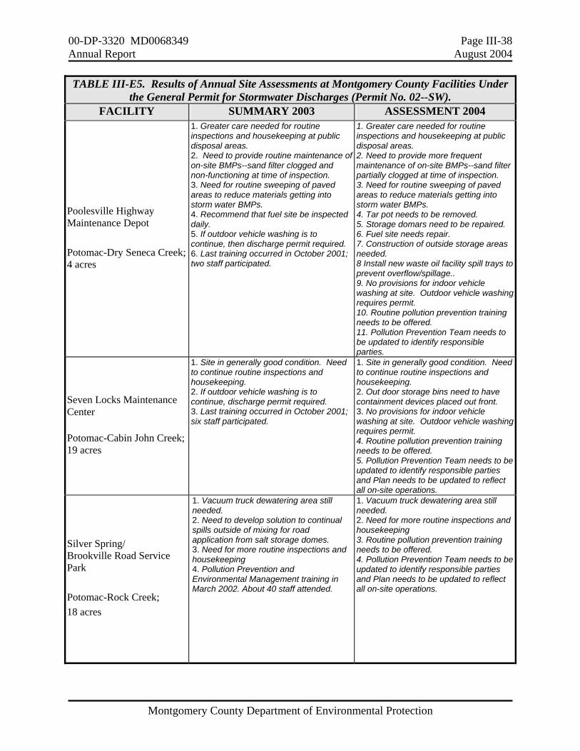
00-DP-3320 MD0068349 Page III-38 Annual Report August 2004
Montgomery County Department of Environmental Protection
TABLE III-E5. Results of Annual Site Assessments at Montgomery County Facilities Under the General Permit for Stormwater Discharges (Permit No. 02--SW).
FACILITY SUMMARY 2003 ASSESSMENT 2004
Poolesville Highway Maintenance Depot Potomac-Dry Seneca Creek; 4 acres
1. Greater care needed for routine inspections and housekeeping at public disposal areas. 2. Need to provide routine maintenance of on-site BMPs--sand filter clogged and non-functioning at time of inspection. 3. Need for routine sweeping of paved areas to reduce materials getting into storm water BMPs. 4. Recommend that fuel site be inspected daily. 5. If outdoor vehicle washing is to continue, then discharge permit required. 6. Last training occurred in October 2001; two staff participated.
1. Greater care needed for routine inspections and housekeeping at public disposal areas. 2. Need to provide more frequent maintenance of on-site BMPs--sand filter partially clogged at time of inspection. 3. Need for routine sweeping of paved areas to reduce materials getting into storm water BMPs. 4. Tar pot needs to be removed. 5. Storage domars need to be repaired. 6. Fuel site needs repair. 7. Construction of outside storage areas needed. 8 Install new waste oil facility spill trays to prevent overflow/spillage.. 9. No provisions for indoor vehicle washing at site. Outdoor vehicle washing requires permit. 10. Routine pollution prevention training needs to be offered. 11. Pollution Prevention Team needs to be updated to identify responsible parties.
Seven Locks Maintenance Center
Potomac-Cabin John Creek; 19 acres
1. Site in generally good condition. Need to continue routine inspections and housekeeping. 2. If outdoor vehicle washing is to continue, discharge permit required. 3. Last training occurred in October 2001; six staff participated.
1. Site in generally good condition. Need to continue routine inspections and housekeeping. 2. Out door storage bins need to have containment devices placed out front. 3. No provisions for indoor vehicle washing at site. Outdoor vehicle washing requires permit. 4. Routine pollution prevention training needs to be offered. 5. Pollution Prevention Team needs to be updated to identify responsible parties and Plan needs to be updated to reflect all on-site operations.
Silver Spring/ Brookville Road Service Park Potomac-Rock Creek; 18 acres
1. Vacuum truck dewatering area still needed. 2. Need to develop solution to continual spills outside of mixing for road application from salt storage domes. 3. Need for more routine inspections and housekeeping 4. Pollution Prevention and Environmental Management training in March 2002. About 40 staff attended.
1. Vacuum truck dewatering area still needed. 2. Need for more routine inspections and housekeeping 3. Routine pollution prevention training needs to be offered. 4. Pollution Prevention Team needs to be updated to identify responsible parties and Plan needs to be updated to reflect all on-site operations.
00-DP-3320 MD0068349 Page III-39 Annual Report August 2004
Montgomery County Department of Environmental Protection
TABLE III-E5. Results of Annual Site Assessments at Montgomery County Facilities Under the General Permit for Stormwater Discharges (Permit No. 02--SW).
FACILITY SUMMARY 2003 ASSESSMENT 2004
Solid Waste Transfer Station/Materials Recycling Facility Potomac-Rock Creek; 43 out of 52.5 acres
1. Outfall specific as well as area assessment provided. 2. Culvert and leachate loading repair needs noted in March and completed in April 2003 3. Used oil stored on-site was removed for recycling. Noted small leaks from equipment and added additional spill absorbent material at site. 4. Two County site managers and two contractor staff received pollution prevention training on June 14, 2002. The leachate treatment plant contractor, Weston Solutions, Inc., also receives company safety and environmental protection training.
1. Outfall specific as well as area assessment provided. 2. General comment to continue with current routine cleaning and maintenance of inlets, storm drains, and general housekeeping. 3. Hazardous Materials Storage Area. Roof over entire area completed. 4. On December 12, 2003, a County site manager as well as representatives from Covanta and MES received Pollution Prevention training at a class provided by DEP. Operations contractors at the Transfer Station, Covanta Energy and Maryland Environmental Service, also have their own environmental and safety training programs. 5. Structural damage to storm water inlets identified in 2003 inspections has been put out for bid to accomplish repairs in the spring of 2004. 6 Pollution Prevention Team needs to be updated to identify responsible parties.
Gude Landfill (closed 1982) Potomac-Rock Creek; 120 acres
1. Outfall specific as well as area assessment provided. 2. Need for some trash removal. 3. Need for leachate seep repairs noted during March and completed by April 2003. 4. One contractor, Covanta Energy, and two site employees attended pollution prevention training on June 14, 2002. The contractor also has its own environmental compliance manager that routinely visits the site and conducts a training program.
1. Outfall specific as well as area assessment provided. 2. Need for some trash removal. 3. Some leachate seep repairs and drainage repairs have been performed in the past year. Additional required repairs have been identified. 4. One contractor, Covanta Energy, and one County employee attended pollution prevention training on December 11, 2003. The contractor also has its own environmental compliance manager that routinely visits the site, does inspections and conducts a training program. 5. Pollution Prevention Team needs to be updated to identify responsible parties
Oaks Landfill Patuxent-Hawlings River and Potomac-Rock Creek; 190 out of 545 total acres
1. Outfall specific as well as area assessment provided. 2. Culvert and leachate loading repair needs noted in March and completed in April 2003 3. Used oil stored on-site was removed for recycling. Noted small leaks from equipment and added additional spill absorbent material at site. 4. Two County site managers and two contractor staff received pollution prevention training on June 14, 2002. The leachate treatment plant contractor, Weston Solutions, Inc., also receives company safety and environmental protection training.
1. Outfall specific as well as area assessment provided. 2. Two of the storm water down chutes from the top of the landfill have had structural shifts and are degraded but still functional. 3. One contractor, Weston Solutions, and one County site manager received pollution prevention training on December 11, 2003. The leachate treatment plant contractor, Weston Solutions, Inc., also receives company safety and environmental protection training. 4. Pollution Prevention Team needs to be updated to identify responsible parties
00-DP-3320 MD0068349 Page III-40 Annual Report August 2004
Montgomery County Department of Environmental Protection
E3. Illegal Dumping and Spills The DEP continues to support its Illegal Dumping Hotline at 240-777-3867 ("DUMP"). During the year 2003, there were 550 complaints of illegal dumping, the vast majority of which concerned bags of trash, vegetation (leaves or brush), or other unwanted materials either dumped or being stored on private or public property. Only a small percentage of these cases represented a potential for direct runoff of contaminated material into a storm drain or receiving stream. Complaint resolution invariably involved removal and proper disposal of trash and debris and proper storage (i.e. under cover) of other materials E4. Sediment and Erosion Control Implementing Program Improvements During 2001, the MDE evaluation of Montgomery County’s application for the delegation of erosion and sediment control enforcement authority identified several inspection and recordkeeping issues. These were addressed by the 2003 MDE review of Montgomery County's erosion and sediment control program, in which MDE stated:
"Results of the field inspection of active construction sites found most to be in good condition and in compliance with erosion and sediment control requirements. Recent program improvements regarding stabilization, documentation, and plan approvals have resulted in better field conditions. When construction sites had erosion and sediment problems, the County's use of enforcement was successful for correcting the violations found. The Sediment Control and Stormwater Inspection staff should be commended for their effort."
Responsible Personnel Certification The Permit requires the County to conduct responsible personnel certification classes to educate construction site operators regarding erosion and sediment control compliance at least three times per year. During 2003, the DPS held 3 classes (June, September, and December) with 36 people in attendance. List of attendees is included in the electronic database in Attachment A. Earth Disturbances for Projects Greater Than One Acre The Permit requires the County to report quarterly on earth disturbances exceeding one acre or more. Data submitted must include site name, site owner and address, disturbed area, local grading permit number, site location, and the type of development (e.g., residential, commercial, etc. During 2003, the DPS continued the required quarterly reports as EXCEL spreadsheets via e-mail to MDE. The annual results are included in the electronic database in Attachment A.
00-DP-3320 MD0068349 Page III-41 Annual Report August 2004
Montgomery County Department of Environmental Protection
E5. Public Education and Outreach Environmental Outreach The DEP continues a multimedia approach for environmental outreach and public education. During 2003, this included buying print advertisements in the Gazette and also in various community guides, producing factsheets available in limited printings and also to be downloaded from the DEP web site, and conducting 14 workshops on Environmental Lawn Care or Home Composting for community groups. The DEP also maintained an extensive calendar of activities for citizen environmental outreach and involvement on the County’s web site. Joe Keyser of DEP continued his weekly column called The GreenMan in the local Gazette newspapers and its video equivalent on the local County cable channel. The GreenMan Show on local Cable Channel 6 was a 2003 Silver Statue Award Winner in the 24th Annual Telly Awards. The Telly Awards are a national showcase for outstanding non-network and cable productions. The GreenMan topics included earth friendly alternative landscaping and lawn care, natural pest control, and using native plants for more sustainable landscapes. The schedule is posted at www.greenmanshow.com The DEP does not have a way of directly measuring how much pollution is reduced by providing this outreach material. However, the continuing requests for this type of information and for workshops from community groups would seem to support resident interest to practice these techniques in their own backyards. Watershed Outreach The DEP's Watershed Management Division (WMD) continues a vigorous outreach program to increase citizen stewardship to protect watershed resources. This includes providing technical assistance and presentations to watershed-based community groups and cooperating with homeowner groups, non-governmental groups, and other local agencies to support partnership efforts. These cooperative efforts are most notable in the Anacostia (as part of the Anacostia Watershed Restoration Agreement) and in the Patuxent (as part of the Patuxent Reservoirs Watershed Protection Agreement. The DEP’s watershed outreach program emphasizes hands-on involvement such as stream clean-ups, storm drain stenciling, and tree plantings. Capital Improvement Program Projects The WMD recognizes that public support is crucial to the successful implementation of watershed restoration projects and routinely holds public meetings for ongoing studies and proposed CIP projects. The project managers occasionally organize Saturday and/or weekday Stream Walks at certain projects to allow the public to see first-hand the extent of existing problems and possible remediation. During 2003, the WMD held 8 public meetings and 3 field meetings with residents on projects in Rock Creek, Watts Branch, Little Falls, and the Hawlings River. In addition to day-to-day management of the consultants engaged in design and construction, the CIP staff are also responsible for responding to telephone calls and inquiries about project status, direction, and erosion problems. Outreach can represent a significant staff time commitment, particularly for projects in densely developed areas or involving privately-owned property. Table III--E6 includes the types and number of project responses required during 2003.
00-DP-3320 MD0068349 Page III-42 Annual Report August 2004
Montgomery County Department of Environmental Protection
Table III-E6. Watershed Restoration Outreach Activities.
Public Meetings • Hawlings River, Project 7a - December 11, 2003 • Northwest Branch, Lower Glenmont Stream Restoration Project -
May 15, 2003, 10 people • Rock Creek, Alta Vista Stream Restoration:
Project Stream Walk- May 31, 2003- 7 people Public Meeting, April 22, 2003- 12 people
• Rock Creek, Stoney Creek SWM Facility (NIH Community Liaison Council) - April 2003, 40 people Maryland-National Capital Park and Planning Commission – April 23, 2003 Mandatory Referral - February 13, 2003, 30 people
• Watts Branch Watershed Study, March 20, 2003- 11 people Field Meetings
• Little Falls-3 people • Rock Creek, Coquelin Run-1 person • Rock Creek, Sycamore Creek Stream Restoration- 10 people
Field Visits • Northwest Branch
Dumont Oaks Stream Restoration – 4 regarding easements Northwood Stream Restoration – 6 regarding project Rollingstone Tributary Watershed– 1 regarding drainage problem, mosquitoes Sherwood Forest Stream Restoration – 4 regarding easements
• Sligo Creek Watershed– 1 native plants, rain garden Telephone/e-mail contacts
• Little Falls- 16 • Northwest Branch
Dumont Oaks Stream Restoration - 5 Northwood Stream Restoration - 10 Sherwood Forest Stream Restoration - 8
• Rock Creek Rock Creek, 2 Alta Vista, Olney Oaks- 12 Josephs Branch- 14 Stoney Creek Stormwater Management Facility - 10 Sycamore Creek- 45
• Watts Branch- 20 Erosion complaints
• Cabin John Creek, Longview Drive Tributary • Northwest Branch, Rollingstone Tributary • Paint Branch, Fairland Farms Tributary • Rock Creek, Lafayette Drive • Rock Creek Tributary, Rosensteel Drive • Watts Branch, Glen Mill Drive

00-DP-3320 MD0068349 Page III-43 Annual Report August 2004
Montgomery County Department of Environmental Protection
Rainscapes In April of 2003, the Chesapeake Bay Trust (CBT) awarded the DEP a grant of $29,125 through its Urban Watershed Restoration Project. This grant was given for educational materials, workshops, and demonstration projects for the "Rainscapes" program that had been developed in early 2002 in partnership with the Potomac Conservancy. The Rainscapes program goes beyond the CIP to involve residents and resource users in pollution source control, water conservation, and creation of backyard wildlife habitat. Figure III-E2 shows the locations of the "Make and Take" Rain Barrel Workshops and the "Rainscapes" Workshops for the CBT project. There are CIP projects being built in four of these five watersheds (Paint Branch, Northwest Branch, Sligo Creek, and Rock Creek) to address stormwater runoff problems. The Upper Patuxent watershed is targeted for watershed protection initiatives because it drains to the Triadelphia Reservoir, which is part of the regional drinking water supply.
Figure III-E2. Locations of Rainscapes Activities.
00-DP-3320 MD0068349 Page III-44 Annual Report August 2004
Montgomery County Department of Environmental Protection
The web site (rainscapes.org) was enhanced to include a "Rainscapes" electronic gazette and also a backyard survey. An example presentation from the DEP Rainscapes workshop is included on CD in Attachment A. During 2003, the DEP conducted four workshops on "Make Your Own Rain Barrels" that were tied to information on urban stormwater control and water conservation. About 120 people participated in these workshops. The Coca-Cola Bottling Plant located near Rockville provided the white plastic barrels free of charge, and the Montgomery County Solid Waste Transfer Station provided trucks large enough to transport 16 barrels at one time. In fall 2003, the DEP conducted "Rainscapes" Workshops for three of four planned demonstration sites to provide background information and basic training for teachers, homeowners, and community groups to design and build their own. The 35 participants at these three workshops were involved in preparing and planting the demonstration sites. The grant-funded portion of this program will be completed during 2004. Plans are underway to assure the continuation of DEP technical support and involvement with interested community groups beyond the CBT funding. Water Quality Advisory Group The Water Quality Advisory Group (WQAG) was created in 1995 through the Water Quality Discharge Law. The Law was necessary to provide enforcement authority against illicit discharges to the County's storm drain system. The 15 voting members represent the academic and scientific, agricultural, business, environmental, and public-at-large communities. There are 3 public agency representatives, one each from the DEP, the Maryland-National Capital Park and Planning Commission (M-NCPPC), and the WSSC. The WQAG meets monthly to discuss and provide recommendations on water quality issues affecting the County. These topics have included drought, groundwater, forest conservation, erosion and sediment control and stormwater, pollution prevention, West Nile Virus, Chesapeake Bay Tributaries Strategies, and wastewater treatment. The WQAG has strongly supported the urban watershed restoration work being conducted by DEP and benefits from active participation by the public agency members who bring first-hand experience with these issues to the meetings. Topics and activities during 2003 included: West Nile Virus Mosquito Control: A Measured Response; Letter of Statement regarding Proposed Future Transportation Corridors; Continued support for Nutrient Management Plan implementation for farmers in the County; Review of the County’s Special Protection Areas Program; Wastewater treatment as related to Chesapeake Bay Pollutant Reduction Goals; Patuxent River Commission presentation on the activities of the Patuxent watershed; Groundwater Program update; Master Planning process discussion.

00-DP-3320 MD0068349 Page III-45 Annual Report August 2004
Montgomery County Department of Environmental Protection
County's Pollution Prevention Program The Pollution Prevention Program in Montgomery County was initiated in 1999 so that the County can improve its overall environmental performance and compliance of regulations and at the same time operate more efficiently and reduce costs, reduce risk, reduce county liability, and provide a safer work environment for employees. As only one staff person was assigned to this task, countywide progress in Pollution Prevention continues to be slow. However, the DEP continues to make progress in pollution prevention training and awareness by providing monthly meetings and initiating a Pollution Prevention Overview Course. Table III-E7 provides a summary of Pollution Prevention Training during 2003 including topic-oriented meetings and the Pollution Prevention Overview course. The Pollution Prevention Overview course is offered to all county employees through the Office of Human Resources. Course objectives are to:
• understand the basic principles and concepts of pollution prevention in the public sector; • understand the applicable regulations and eliminate or greatly reduce violations of these
regulations; • identify ways to reduce hazardous substances, pollutants, or contaminants; and, • develop an action plan to prevent and manage pollution.
Montgomery County Environmental Policy During 2003, the County Council and County Executive approved a resolution creating the Montgomery County Environmental Policy. The Policy required that all County Agencies and Departments develop an Environmental Action Plan by June 30, 2004 to document existing efforts for environmental protection or improvement and also set goals for the coming year. The resolution created an interagency steering committee called the Environmental Policy Implementation Task Force to identify a framework for tracking progress from year to year. The County Executive's Office held a kickoff meeting for all agencies and departments in May, 2004. Features of the resulting Environmental Action Plan will be included in next year's Annual Report.
Table III-E7. Pollution Prevention Training During 2003
Date 10/30/03 2/26/04 12/4/03 12/11/03 Training Topic
Maryland requirements for storing or disposing of hazardous wastes. Guest Speaker: Ed Hammerberg, Chief of the Regulations Regulations/Permitting Division in the Hazardous Waste Program of the Maryland Department of the Environment.
Roundtable discussion on goals for the pollution prevention program, goals reached last year, RCRA & NPDES compliance, assistance needed from the P2 Coordinator, and upcoming pollution prevention events.
Basics of Pollution Prevention
Basics of Pollution Prevention
# Attendees 8 9 11 13
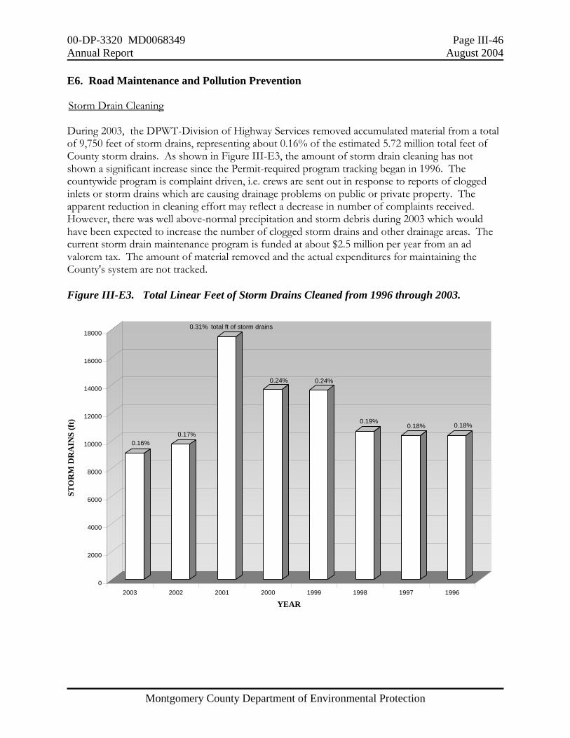
00-DP-3320 MD0068349 Page III-46 Annual Report August 2004
Montgomery County Department of Environmental Protection
E6. Road Maintenance and Pollution Prevention Storm Drain Cleaning During 2003, the DPWT-Division of Highway Services removed accumulated material from a total of 9,750 feet of storm drains, representing about 0.16% of the estimated 5.72 million total feet of County storm drains. As shown in Figure III-E3, the amount of storm drain cleaning has not shown a significant increase since the Permit-required program tracking began in 1996. The countywide program is complaint driven, i.e. crews are sent out in response to reports of clogged inlets or storm drains which are causing drainage problems on public or private property. The apparent reduction in cleaning effort may reflect a decrease in number of complaints received. However, there was well above-normal precipitation and storm debris during 2003 which would have been expected to increase the number of clogged storm drains and other drainage areas. The current storm drain maintenance program is funded at about $2.5 million per year from an ad valorem tax. The amount of material removed and the actual expenditures for maintaining the County's system are not tracked. Figure III-E3. Total Linear Feet of Storm Drains Cleaned from 1996 through 2003.
0.16%0.17%
0.24% 0.24%
0.19%0.18% 0.18%
0
2000
4000
6000
8000
10000
12000
14000
16000
18000
STO
RM
DR
AIN
S (f
t)
2003 2002 2001 2000 1999 1998 1997 1996
YEAR
0.31% total ft of storm drains

00-DP-3320 MD0068349 Page III-47 Annual Report August 2004
Montgomery County Department of Environmental Protection
Street Sweeping In 2001, the DEP published a report which supported the importance of the County's street-sweeping program in reducing solids being carried into its stormwater management facilities and waterways. The County's program was primarily a means to clean up any remaining salt, sand, and grit applied during the winter months and to keep County roads free of debris and trash throughout the year. During the first Permit period, the DPWT program removed a fairly consistent amount per year (an average of about 2,322 tons of materials). The total tons of sand and salt applied varied from 13,144 to 39,224 tons per winter, depending on the number of snow and ice events. There was no DPWT funding budgeted for streetsweeping during 2002 and only 183 curb miles out of about 2,200 County-maintained miles were swept. In FY03, the DEP agreed to cost-share for vacuum streetsweeping as a best management practice to reduce the amount of solids that could enter County-maintained stormwater management facilities. The DEP provided approximately $112,000 of the total $320,000 cost. The DEP requested that areas with stormwater management ponds and dense urban development should be swept first, including those in the Anacostia and Watts Branch watersheds. The DPWT had previously rotated among the sweeping routes so that no one area would always be the first swept. In 2003, the DPWT also required the sweeping contractor to keep track of the total amount of material swept by route, to translate into pounds collected per curb mile. This would allow comparison across different areas of the county and would be useful to identify the "dirtiest" areas to be swept first, or more frequently, for greatest cost-effectiveness. Areas with the greatest accumulated amount should be swept before rainfall and traffic dissipated the materials into the storm drain system. From April into August, 2003, the DPWT-Highway Services swept 3,895 curb miles of arterial roads and 182 miles of residential roads, collecting 4,451 tons of materials. This represented the highest average amount collected (about 1.09 ton per curb mile) since DEP began reporting curb miles swept. The average amount collected from 1999-2001 was only 0.449 tons per curb mile. However, 66,645 tons of salt and sand had been applied during the very cold and snowy winter of 2002/2003, so that less than 10% of the applied material was collected by the subsequent sweeping operation. Figure III-E4 shows a comparison of sweep start dates and amount collected per curb mile. In general, the areas in the southern, more urbanized parts of the County showed the highest per curb mile collection rate regardless of sweep start date. There were some exceptions to this pattern, such as the Town of Poolesville in western Montgomery County which was among the last areas swept but in the highest category for material collected per curb mile. Areas in the southern part of the County tended to show higher amount collected per curb mile, regardless of start date. The 2004 street sweeping data will be analyzed in a similar fashion and then recommendations made on which specific areas to sweep first, to condense sweeping into less than the five months currently allotted, and to consider multiple sweepings in those areas with the greatest amounts of accumulated material.
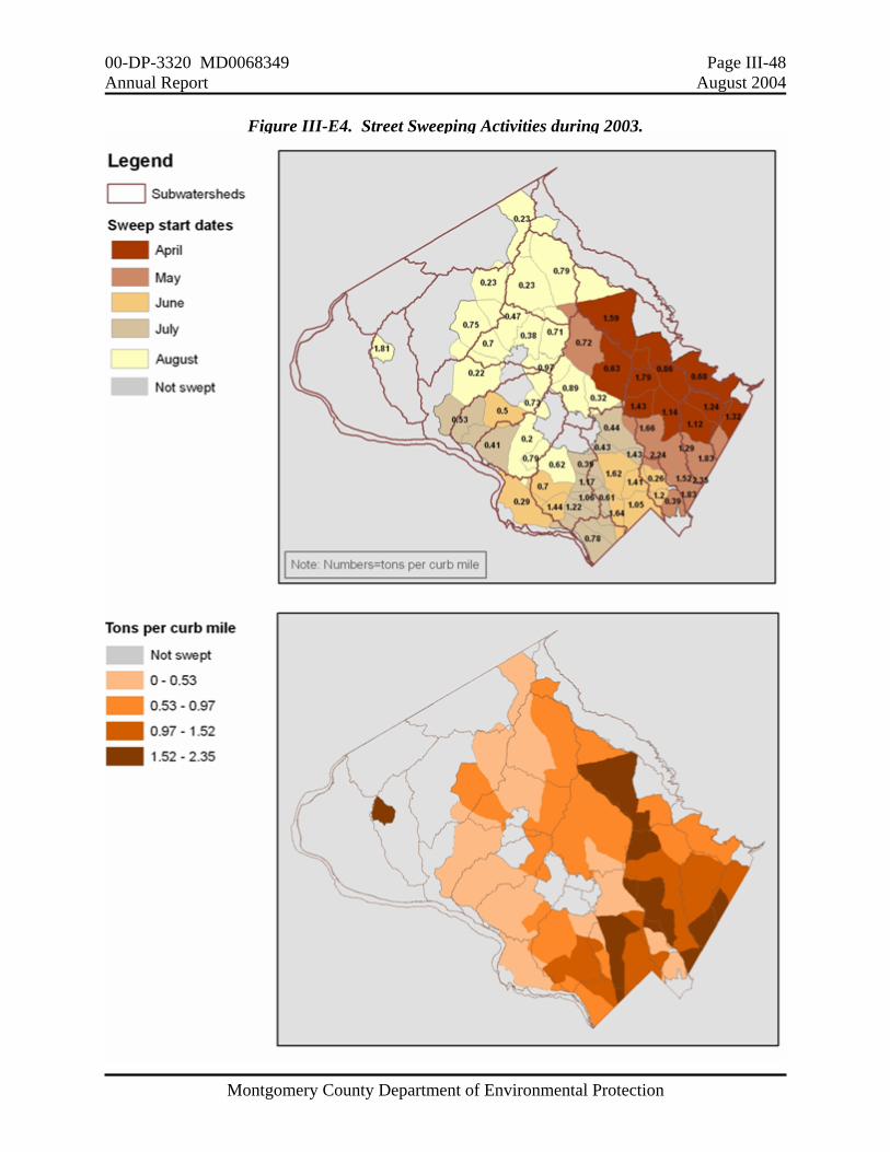
00-DP-3320 MD0068349 Page III-48 Annual Report August 2004
Montgomery County Department of Environmental Protection
Figure III-E4. Street Sweeping Activities during 2003.

00-DP-3320 MD0068349 Page III-49 Annual Report August 2004
Montgomery County Department of Environmental Protection
E7. Integrated Pest Management Montgomery County is required to examine the use, control, and reduction of herbicide, pesticide, and fertilizer for all of its departments. The County continues to implement its Integrated Pest Management (IPM) program at county-owned facilities by the DPWT-Division of Operations. There were no fertilizers applied at any of these facilities during 2002 or 2003. Table III-E8 shows pesticide use at facilities maintained by the DPWT-Division of Operations for calendar years 2003 and 2002. The increase in quantities compared to years past reflects the increase in facilities covered under the DPWT IPM Program. The new County Correctional Facility in Clarksburg, the Glen Echo Park, the County’s Department of Recreation facilities and the DPWT depots were all added in 2003, increasing coverage from 190 acres at 88 facilities to 230 acres at 96 facilities. The amount of square footage under the Structural Pest Control Program increased from 1,175,000 to 1,375,000 square feet.
Table III-E8. Pesticide Usage for Calendar Years 2003 and 2002.
Purpose 2003 2002
Landscaping No fertilizers were applied.
230 acres at 96 facilities Roundup 10 gallons (undiluted)
198 acres at 88 facilities
Roundup 10 gallons (undiluted)
Structural Pest Control *Outside use only.
1,375,000 sq ft at 75 facilities Maxforce gel 18.75 (lb) Boric Acid 59.00 (lb) Roach glue boards 187 ea. Maxforce roach baits 482 ea. Drax ant gel 10 (lb) Wasp spray (32 cans) 48 (lb)* Delta Guard (granules) 500 (lb)* Talon-G (rodent bait) 12.25 (lb)*
1,175,000 sq ft at 73 facilities Maxforce gel 5.43 (lb) Boric Acid 39.37 (lb) Roach glue boards 1,293 ea. Maxforce roach baits 530 ea. Drax ant gel 5.06 (lb) Wasp spray (5 cans) 7.5 (lb)* Delta Guard (granules) 160 (lb)* Talon-G (rodent bait) 11.25 (lb)*
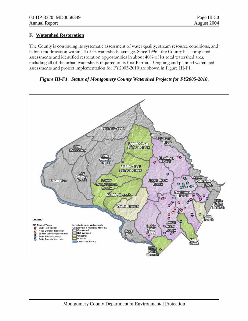
00-DP-3320 MD0068349 Page III-50 Annual Report August 2004
Montgomery County Department of Environmental Protection
F. Watershed Restoration The County is continuing its systematic assessment of water quality, stream resource conditions, and habitat modification within all of its watersheds. acreage. Since 1996, the County has completed assessments and identified restoration opportunities in about 40% of its total watershed area, including all of the urban watersheds required in its first Permit.. Ongoing and planned watershed assessments and project implementation for FY2005-2010 are shown in Figure III-F1.
Figure III-F1. Status of Montgomery County Watershed Projects for FY2005-2010.

00-DP-3320 MD0068349 Page III-51 Annual Report August 2004
Montgomery County Department of Environmental Protection
During 2003, the County completed the Hawlings River Watershed Restoration Study and began a watershed restoration inventory in the Great Seneca Creek and Muddy Branch watersheds. The inventory will be a cooperative effort with the COE and the City of Gaithersburg. These two drainage areas represent roughly one-third of the total County land area and include drainage from the densely developed areas of Gaithersburg and Germantown. Table III-F1 summarizes the status of the DEP's significant watershed restoration efforts through 2003. Total cost through December 2003 (including State and Federal cost-share funding) for watershed restoration efforts completed or underway has been $22.9 million dollars. The results from the Permit-required monitoring and restoration assessments continue to be used to support the Countywide Stream Protection Strategy. The 2003 update is included in electronic format on CD in Attachment A. The 2003 update supports monitoring conclusions that have been passed on in previous Annual Reports. The primary causes of biological impacts to County streams continue to be stream erosion and associated sedimentation. The Permit-required restoration efforts will continue to focus on addressing those major impairments.
TABLE III-F1 . Montgomery County Watershed Restoration Studies and Projects.
(1996-2003). * Estimated costs for those projects still under design.
Table III-F1. Status of Watershed Restoration Studies and Project Implementation.
Project Type Completed Underway or In design
Cost * ($m)
Watershed Study
Upper Paint Branch; Northwest Branch; Rock Creek; Hawlings River (219.5 sq. miles)
Cabin John Creek; Lower Paint Branch ( 94.3 sq. miles)
3.131
Stormwater Retrofit
659 acres (9 projects) 4,040 acres (26 projects) 8.259
Stream Restoration 8.25 miles (13 projects) 33.8 miles (38 projects) 11.472
00-DP-3320 MD0068349 Page III-52 Annual Report August 2004
Montgomery County Department of Environmental Protection
F1. Watershed Screening Biological and Physical Habitat Monitoring The DEP continues its countywide biological and physical habitat monitoring to identify and evaluate water quality problems by subwatershed. The DEP is in its second round of countywide monitoring of all subwatersheds. In 2003, monitoring was completed at 60 stations in five subwatersheds (Bennett Creek, Cabin John Creek, Fahrney Branch, Little Bennett Creek, and Rock Creek ). The one station monitored in Fahrney Branch showed no impairment in the biological community, rated "good" for habitat with an "excellent" fish and "good" benthic community. Of the remaining 59 biological monitoring stations, 15 (25%) had impairment in both fish and benthic macroinvertebrates. These 15 stations shown in Table III-F2 were identified from the biological monitoring and stream habitat assessments as having impairment other than that which could be attributed to habitat conditions alone. The majority of these stations was lacking pollution-intolerant species and had evidence of fine sediment deposition. Five stations (CJSB101, CJBC202, LRLR201, LRSB101A, and LRTB202A) were found to have only one fish species. This may reflect still existing impacts from the 2002 drought which resulted in very little or no baseflow in some of smaller tributaries. Pioneering fish species would be expected to dominate at these stations since these species rapidly colonize once more normal conditions return. Thirteen of the 15 stations shown in Table III-F2 are located in the Cabin John Creek or Rock Creek watersheds. Three of these 13 stations (CJSB101, LRLR201, and LRSB101A) were listed as impaired by previous monitoring but follow-up outfall screening did not find chronic water chemistry problems. Six of these 13 (CJBC202, CJSB101, LRJB204, LRSB101A, LRTB202A, LRTB203C) are located in subwatersheds where the County is already pursuing stormwater retrofits and stream restoration projects and were included in previous investigations for illicit discharges to the storm drain system.. It is possible that project implementation in the drainage to these stations will also reduce the sources of the existing impairments. The remaining seven stations in these two watersheds, along with the single station each in Bennett Creek and in Little Bennett Creek, will be investigated as part of the County’s illicit discharge screening program for 2004.. These nine stations are highlighted in yellow in Table III-F2.
00-DP-3320 MD0068349 Page III-53 Annual Report August 2004
Montgomery County Department of Environmental Protection
Table III-F2: Biological Monitoring Stations with Possible Impairment not Associated with Long-Term Physical Stressors. The highlighted stations are in reaches which need follow up to identify other than physical habitat factors which are producing impairments.
WATERSHED STATION
LOCATION and POSSIBLE CAUSES OF IMPAIRMENT FOLLOW UP ACTIONS
BENNETT CREEK
BCBC208 Bennett Creek Mainstem, Clarksburg Road. DLF, SSE, and ESC. Infrequent riffles.
Field investigation to determine upstream sediment impairment and possible fish blockage at Clarksburg Road.
CABIN JOHN CREEK
CJBC202 Booze Creek, River Road. SSE, STP, IWT
Field investigation at Holton Arms School to evaluate and inspect sediment control. At least two sediment spills were noted from Holton Arms School’s property. This reach is included in an ongoing watershed assessment and restoration opportunities study.
CJSB101 Snakeden Creek, Seven Locks Road. SSE, DBS, banks unstable and sediment problems.
Field investigation to determine sediment impairment and evaluate storm-water flows. Restoration of this stream will be conducted.
LITTLE BENNETT CREEK
LBBR202 Browning Run, Clarksburg Road. Drought recovery, STP possible due to elevated pH readings in the spring. Banks unstable.
Field investigation to perform a continuous water chemistry test with Hydrolab to monitor long-term pH readings. Further upstream, a manure pond was breached for a period of time before being repaired.
LOWER ROCK CREEK
LRJB204 Beach Drive. Banks unstable, minimal bank vegetation, and sediment problems. Stream restoration will begin June 2004.
LRLB202 Grosvenor Place. LTP, IWT, banks unstable and sediment problems.
Field investigation to analyze water chemistry above station and evaluate stormwater flows with focus on sediment impairment. Continuous water temperature will also be recorded.
LRLR201 Avery Road. Large natural fish blockage just downstream, LTP, Unstable habitat and large amount of human trash. High conductivity readings
Field evaluation to determine source of trash in stream and perform water chemistry. Joint efforts with the City of Rockville will be examined.
LRLR425 Beach Drive. DBS, Heavy sediments found, lacking habitat for fish and bugs.
Field investigation to evaluate stormwater flows with focus on sediment impairment.
LRSB101A Bauer Drive. DBS, sediment deposition and unstable banks.
Stream restoration will be completed in the Fall of 2004.
LRTB202A Beret Lane. Unstable banks and little riparian buffer.
Stream restoration will begin Fall 2004. There was a fish kill in this tributary on July 24, 2000.
LRTB203C Edgebrook Road. IWT, high conductivity readings, and LTP.
Stream restoration will begin Fall 2004. There was a fish kill in this tributary on July 24, 2000.

00-DP-3320 MD0068349 Page III-54 Annual Report August 2004
Montgomery County Department of Environmental Protection
Table III-F2: Biological Monitoring Stations with Possible Impairment not Associated with Long-Term Physical Stressors. The highlighted stations are in reaches which need follow up to identify other than physical habitat factors which are producing impairments.
WATERSHED STATION
LOCATION and POSSIBLE CAUSES OF IMPAIRMENT FOLLOW UP ACTIONS
UPPER ROCK CREEK
URST201 Southlawn Tributary
This stream has numerous permitted and grandfathered point source discharges. DEP has and will continue to investigate violations, but the stream is severely impaired.
URNB302 Upstream of Bowie Mill Road Field investigation to determine sediment impairment, data indicates embeddedness and sediment deposition problems.
URFV101 Flower Valley. DBS.
Field investigation to determine sediment impairment and perform 24 hour monitoring of conductivity. Determine source of sediment impairment.
URRC402 Rock Creek Mainstem. DBS, IWT Lower summer dissolved oxygen readings.
Field investigation to determine sediment impairment and perform 24 hour monitoring of dissolved oxygen. Long-term water temperature will also be collected. A 30% concept design for stream restoration. has been completed for the reach including this station.
Winter/Spring High Flows = WHF Summer High Flows = SHF Suspended Sediment Event = SSE Drought Low Flow = DLF Increased Water Temperature = IWT Degraded Benthic Substrate = DBS Entrenched Stream Channel = ESC Short Term Pollutant Event = STP Long Term Pollutant Event = LTP

00-DP-3320 MD0068349 Page III-55 Annual Report August 2004
Montgomery County Department of Environmental Protection
Bennett Creek Figure III-F2 shows biological monitoring results for the Bennett Creek watershed. Four stations scored good to excellent for both habitat and biological conditions. One station, BCBC301, scored good for habitat conditions, excellent for benthics, but fair for fish. Only one station, BCBC208, showed a good habitat condition and a fair biological condition for both fish and benthics and thus potential impairment from other than habitat factors. In 1999, this station was determined to have inconclusive results about whether this tributary was impaired solely by habitat stressors. It is believed that this tributary showed the lingering effects from the 2002 drought. Field investigations will be conducted to determine if the new bridge on Clarksburg Road may be a contributing fish blockage. Sediment deposition and bank instability at this station support further investigation for possible contributing upstream land uses. Cabin John Creek As shown in Figure III-F3, the Cabin John watershed showed little to no impairment from other than habitat factors for all but two stations (CJBC202 and CJSB101). Most of this watershed is being evaluated for stormwater retrofits and stream restoration opportunities. .Station CJBC202 is located in Booze Creek, at the Holton Arms School which had at least two noted sediment spills. To the best ability, clean up of sediments in the flood plain and stream were conducted after both incidences. In addition, improved stormwater controls were added to prevent further sediment releases from their property. Stream restoration is underway for the entire Booze Creek subwatershed. CJSB101 is rated as a high priority to begin stream restoration in 2005. Little Bennett Creek In Little Bennett, only one of the 15 stations monitored, LBBR202, scored good habitat but fair biological conditions for both fish and bugs. Results are shown in Figure III-F4. During the spring benthic collection, a high pH reading was recorded and may be an indication of a water chemistry problem. In addition, there is a manure pond upstream of this station that was breached for a period of time, which might have also contributed to the degradation of this stream. Corrective action has been taken to prevent further breaching.
00-DP-3320 MD0068349 Page III-56 Annual Report August 2004
Montgomery County Department of Environmental Protection
Figure III-F2. Identifying Impairment by other than Physical Habitat in Bennett Creek during 2003. Line shows expected direct correspondence between biological and habitat conditions.
00-DP-3320 MD0068349 Page III-57 Annual Report August 2004
Montgomery County Department of Environmental Protection
Figure III-F3. Identifying Impairment by other than Physical Habitat in Cabin John Creek during 2003. Line shows expected direct correspondence between biological and habitat conditions.

00-DP-3320 MD0068349 Page III-58 Annual Report August 2004
Montgomery County Department of Environmental Protection
Figure III-F4. Identifying Impairment by other than Physical Habitat in Little Bennett Creek during 2003. Line shows expected direct correspondence between biological and habitat conditions.
00-DP-3320 MD0068349 Page III-59 Annual Report August 2004
Montgomery County Department of Environmental Protection
Lower Rock Creek Of all watersheds monitored in 2003, Lower Rock Creek had the most stations showing impairment from other than habitat. As shown in Figure III-F5, seven of the 10 stations (LRJB204, LRLB202, LRLR201, LRLR425, LRSB101A, LRTB202A, and LRTB203C) monitored were found to have fair to good habitat condition while the biological conditions ranged between poor and fair conditions. All of these stations were observed to have heavy sediment deposits that inhibited the riffle/benthic species for both the benthics and fish. Stream restoration in LRJB204’s tributary’s began in June 2004. Stream restoration construction will be completed by fall of 2004 in the tributary where LRSB101A is located and near station LRSB101A. Elevated water temperatures and possible poor water chemistry are a concern at station LRLB202. Follow up monitoring will be conducted. This station is located in a stream that runs through an old dump, which may be leaching out and contaminating the stream. Coordination with DEP environmental enforcement and the City of Rockville will be conducted for determining potential pollutant sources. Station LRLR425 was observed to have minimal stable habitat for benthics and fish and also an elevated amount of fine sediments. Additional field evaluation will be conducted on stormwater flows and controlling impervious surface runoff. Two of the Lower Rock Creek stations are in Turkey Branch, the first subwatershed selected for the Permit-required watershed restoration requirement. Invasive bamboo and a mowed lawn have disrupted the riparian buffer at station LRTB202A. Station LRTB203 had elevated water temperature and high conductivity which could be impairing the biological communities in this tributary. This tributary is still recovering from a fish kill on July 24, 2000 when an asphalt application on a parking lot was washed into the stream by a rain event. Over 1,000 fish, 1,000 crayfish, and numerous aquatic insects were killed as a result of the sealant containing a coal, tar, clay, and latex mixture. Stream restoration will begin in this tributary in the fall of 2004 and post-construction monitoring will be used to determine success of the restoration effort. Upper Rock Creek As shown in Figure III-F6, four (URFV101, URST201, URNB302, and URRC402) of 18 stations had a combination of good habitat with fair to poor biological condition. High conductivity, water temperature, and sediment deposition seemed to be the contributing stressors on the biological communities at URFV101. The DEP has prepared a 30% concept design for stream restoration near this station. URST201 is in the Southlawn Tributary, a drainage with a long history of problems from heavy commercial and industrial land uses. Many of the industrial facilities now have NPDES permits with specific water quality limits. URNB302 is on the North Branch of Rock Creek just above Bowie Mill Road. Sediment deposition was observed in this area. Station URRC402 had low dissolved oxygen readings, elevated water temperatures, and degradation of the riffles by fine sediments.
00-DP-3320 MD0068349 Page III-60 Annual Report August 2004
Montgomery County Department of Environmental Protection
Figure III-F5.. Identifying Impairment by other than Physical Habitat in Lower Rock Creek during 2003. Line shows expected direct correspondence between biological and habitat conditions.
00-DP-3320 MD0068349 Page III-61 Annual Report August 2004
Montgomery County Department of Environmental Protection
Figure III-F6.. Identifying Impairment by other than Physical Habitat in Upper Rock Creek during 2003. Line shows expected direct correspondence between biological and habitat conditions.
00-DP-3320 MD0068349 Page III-62 Annual Report August 2004
Montgomery County Department of Environmental Protection
F2. Selected Restoration Watershed Restoration Goal The Permit requires the County to track progress and evaluate effectiveness of implementing programs and projects to restore a drainage area "equaling ten percent of Montgomery County’s impervious area that has not been treated to the maximum extent practicable". In the Annual Report for 2001, the County estimated the amount of its uncontrolled impervious area using an average imperviousness of 20% for developed land acreage (residential, commercial, and industrial) and acreage controlled by BMPs as reported for pollutant loads generation. The watershed restoration goal was estimated as 1,398 acres and this number was used for the subsequent selection of the 2,434 acre Turkey Branch subwatershed in the Lower Rock Creek watershed. For the Annual Report for 2002, the restoration goal acreage was adjusted to 1,418 acres based on updated electronic mapping and attribute information. The revised analysis for 2003 is shown in Table III-F3. There has been a significant increase in the number of acres reported under control for 2002 (45,660 vs. 35,706). This reflects the completion of drainage area delineations and verifications for the Source Identification elements of the Permit.
Table III-F3. Impervious Surface Analysis for Watershed Restoration Goal
Total County Acres 324,552
Total Acres of Impervious Surface 30,805.0 (2003) 29,127.5(2002)
Total Acres of Impervious Surface minus exclusions
14,117.1 (2003) 14,182.1 (2002)
10% Goal in Acres (based on Annual Report for 2002) 1,418.2
Turkey Branch (Restoration Watershed) in Acres 2,434
Excluded Areas: (total area, not just impervious area; in acres, except for State Maintained Roads)
Rural Zoning (RC, RDT, and RZ) 96,692
Parklands and Forests 61,284
Municipalities with own stormwater management programs Rockville 8,614 Gaithersburg 6,402 Takoma Park 1,335
Large Federal Properties 2,761
State Maintained Roads 1,411.7 miles
Existing Controls
Stormwater BMPs (by Year) 45,660 (2003) 35,706 (2002)
Drainage to Stream Restoration Projects (completed in 2003 or before) 1,814

00-DP-3320 MD0068349 Page III-63 Annual Report August 2004
Montgomery County Department of Environmental Protection
Turkey Branch Watershed A detailed assessment of the Turkey Branch subwatershed and a restoration schedule was submitted in January, 2003 as required in the Permit. Two stream restoration projects in Lower Turkey Branch, covering impacts in 1.7 linear miles of stream, are expected to be completed by December 2004. Two new stormwater management ponds for control to 217 acres and a dry pond retrofit for 189 acres are expected to be constructed during 2005. Pre-construction monitoring was conducted during 2002 and 2003. Post-construction monitoring will take place one year, three years, and then five years after completion of the projects to assess changes in stream condition. During 2002, six stations were monitored in the Turkey Branch watershed. Locations were previously submitted. Monitoring was completed for benthic macroinvertebrates, physical/chemical grab samples, and habitat assessments at all stations and for fish at five of the six stations. The overall watershed stream condition is “poor”. Summary scores and narrative ratings for benthic and fish IBIs for both 2002 and 2003 are provided in Table III-F4. The reach at station LRTB202A was dry when fish monitoring was originally scheduled so that pre-construction fish monitoring was actually conducted in 2003. Fish monitoring was repeated at LRTB202A and LRTB203C in 2003 to compare with results from the drought of 2002.
Table III-F4. Pre-Construction Biological Monitoring in the Turkey Branch Watershed. (B=Benthic, F=Fish, IBI=index of biological integrity).
BIBI FIBI
Station Date Summary Score
Narrative Rating
Date Summary Score
Narrative Rating
LRTB101 4/17/2002 12 Poor 7/19/2002 1.9 Poor LRTB202 4/18/2002 14 Poor 7/19/2002 1 Poor LRTB202A 4/17/2002 16 Poor 7/16/2003 1 Poor LRTB203A 4/17/2002 18 Fair 7/19/2002 1.7 Poor LRTB203A 3/25/2003 14 Poor LRTB203B 3/22/2002 16 Poor 7/16/2002 1.9 Poor LRTB203C 4/19/2002 10 Poor 7/24/2002 2.8 Fair LRTB203C 3/25/2003 16 Poor 7/16/2003 2.3 Fair
00-DP-3320 MD0068349 Page III-64 Annual Report August 2004
Montgomery County Department of Environmental Protection
G. Program Funding The Permit requires the County to submit a fiscal analysis of its expenditures and maintain adequate program funding to comply with all conditions of this permit. Table III-G1 compares expenditures in FY04 with those budgeted for FY05. The County's fiscal year runs from July 1 of one year to June 30 of the next. The funding under Watershed Restoration CIP for watershed assessments, project identification, and project construction represents the single largest category of total expenditures, about 48% proposed for FY05. The costs for the Stormwater Maintenance Inspections and Facility Repairs represent about 25% of the total proposed for FY05.
TABLE III-G1. Montgomery County’s Funding for Fiscal Years (FY) 2003-2005 for Permit-required Programs. (CIP=Capital Improvement Project).
Thousand $s by fiscal year
PERMIT CATEGORY
FY03 FY04 FY05 C. Source Identification Storm Drain Inventory 31* 98 195D. Discharge Characterization Outfall and Instream Station Water Chemistry
Monitoring 50 50 50E. Management Programs Stormwater/Sediment Control Casework Management 369 394 322Plan Review-Stormwater Management and Sediment/Erosion Control 864 924 1,220Maintenance Inspections 989 899 1,379Stormwater Facility Repairs
WQPC 1,005** 2,773 2,968operating 26
DEP Public Outreach and Coordination 333 339 265Water Quality Discharge Law Enforcement 246 268 254Inspection-Stormwater Management and
Sediment/Erosion Control 945 956 1,178Street Sweeping
DPWT DEP
11.7 208 112
208112
Baseline and Reference Stream Monitoring (includes integrated Discharge Characterization and Design Manual programs) 574 572 612
Countywide Groundwater Monitoring Program 185 262 236Watershed Assessments and Action Plans (includes
inventories, planning studies, project design, and construction): CIP 5,395 4,267 8,304
TOTAL 11,023 12,148 17,303* Reduced from budgeted $140,000 to meet mandated mid-year reductions. ** Reflects establishment of Water Quality Protection Charge (WQPC) to fund phase-in of public
maintenance responsibility for privately-owned residential facilities.

00-DP-3320 MD0068349 Page III-65 Annual Report August 2004
Montgomery County Department of Environmental Protection
H. Assessment of Controls The permit requires the County to annually submit estimates of expected pollutant load reductions as a result of its proposed management programs. For consistency with the Tributary Strategies process, the County has begun using the Chesapeake Bay Program (CBP) guidelines for BMP removal efficiencies to estimate pollutant load reduction calculations. These assumptions are shown in Table III-H1. As detailed in last year's Annual Report, the average percent reduction is lower for the CBP guidelines than used in previous assessments of County controls.
Table III-H1. Chesapeake Bay Program: Urban Storm Water Best Management Practices. Pollutant Removal Efficiencies.
PARAMETER TN TP TSS
Wet Ponds and Wetlands 30 50 80
Category B. Dry Detention Ponds and Hydrodynamic Structures
5 10 10
Category C. Dry Extended Detention Ponds
30 20 60
Category D. Infiltration
50 70 90
Category E. Filtering Practices
40 60 80
Category F. Roadway Systems
TBD TBD TBD
Category I: Stream Restoration
0.02 lb/linear ft/yr
0.0035 lb/linear ft/yr
2.55 lb/linear ft/yr
Table III-H2 shows the estimate of TN and TP annual stormwater loads from developed lands and the reductions associated with existing stormwater controls in the County. Approximately 35.1% of all developed lands are under some form of stormwater management, with an estimated 8.4% reduction in TN and a 16.9% reduction in TP loadings in runoff due to those controls. The County will continue to implement stormwater retrofits as sites and funding become available. Finding suitable sites is becoming more difficult and construction costs are much higher in the most densely-developed areas. These are typically the areas with the most physically degraded streams. The County is more closely evaluating alternatives to stormwater management ponds, including smaller on-site structures such as bioretention areas for commercial facilities and rain gardens in residential areas to augment the watershed restoration CIP program. However, there is limited data currently available to quantify the benefits of these alternative urban runoff control approaches.
00-DP-3320 MD0068349 Page III-66 Annual Report August 2004
Montgomery County Department of Environmental Protection
TABLE III-H2. Stormwater Delivered Loads for the Year 2003 (lbs/year) from developed acres in Montgomery County
Annual Report TN (lbs/yr) TP (lbs/yr)
Acres Developed 147,464 1,268,190 122,395
Acres with BMPS (estimated) 51,713 1,1619,08 101,662
% acres controlled 35.1 % reduced 8.4 % reduced 16.9 average % reduction efficiency
(based on Bay Program efficiencies by type 21.3 40.0average Loading (lbs/acre)
(based on County monitoring 1994-2001)8.6 0.83
00-DP-3320 MD0068349 Page IV-1 Annual Report August 2004
Montgomery County Department of Environmental Protection
PART IV. SPECIAL PROGRAMMATIC CONDITIONS The Permit requires that the County assist with the implementation of the Tributary Strategies to meet nutrient reductions goals for the Tributary Basins that it lies within. These are the Middle Potomac and the Patuxent River Tributary Basins. During 2003, the County continued to participate in the activities of both the Middle-Potomac Tributary Team and the Patuxent River Commission as the Maryland Tributary Strategies were being defined. The Executive Summary was published in April 2004, with an update in June 2004 to show reduction targets for each of the ten Tributary Basins. There were no reduction targets by County as had been expected based on lengthy discussions with State Tributary Strategy staff. The Department of Natural Resources has now convened the Tributary Strategy Implementation Committee to develop implementation plans for each tributary basin by December 2004. Montgomery County and the other more urban localities have requested that the Tributary Basin information be broken out by County. This breakout is necessary so that each locality can better identify any additional programs and resources needed to specifically meet the Bay mainstem and tidal tributary water quality goals beyond those being used to meet local Permit-required water quality protection goals. The DEP also participates in a variety of statewide, regional and interjurisdictional forums for water quality protection and management. • The DEP rejoined the Board of the Maryland Water Monitoring Council (MWMC) during 2003
and expanded its involvement in MWMC activities. During this year, the DEP has:
1. Participated in the Roundtable Workshop on Annual Monitoring Plans and forwarded station locations for posting on the MWMC "Clickable Map" of programs
2. Compiled information on non-state programs (e.g. academic, federal, local, and volunteer) from the Monitoring Program Surveys and the Roundtable Workshop for use in the State Water Monitoring Strategy document
3. Participated in the MWMC Groundwater Level Workgroup 4. Participated in the poster session and attended the Annual Meeting in November.
• The County continued its ongoing multi-jurisdictional efforts to protect the Anacostia and the
Patuxent Reservoirs Watershed. This has led to cooperative funding for monitoring, modeling, and restoration and retrofit project inventories, design, and construction. The County monitoring results are being used for regional screening and priority setting in these watersheds. The projects that are being built contribute toward the County's Permit-required watershed restoration goal and also the pollutant reductions that will be needed to meet the Tributary Strategies nutrient caps.
Who to Call If you Have a Watershed or Water Quality Question: Montgomery County Agencies Department of Environmental Protection (DEP) http://www.montgomerycountymd.gov/siteHead.asp?page=/mc/services/dep/index.html Countywide Monitoring ..................................................................... 240-777-7726 Hawlings River Watershed Restoration ............................................ 240-777-7711 Illegal Dumping Hotline..................................................................... 240-777-7700 Rainscapes .......................................................................................... 240-777-7720 Stormwater Management Structures ................................................. 240-777-7744 Water Pollution................................................................................... 240-777-7770 Watershed Outreach and Stewardship............................................... 240-777-7714 Department of Permitting Services (DPS) Sediment from construction site entering streams.............................. 240-777-6366 Stormwater management and sediment control plan review issues ... 240-777-6320 Water supply wells and septic tank issues.......................................... 240-777-6300 Department of Public Works and Transportation (DPWT) Blocked storm drain, inlet pipe or erosion from public storm drain240-777-ROAD Recycling and hazardous household waste disposal .......................... 240-777-6400 Soil Conservation District Agricultural best management practices ............................................ 301-590-2855 Inter-County Agencies Maryland-National Capital Park and Planning Commission (M-NCPPC) Problems with streams, trash and debris in County parks and in streams301-495-2535 Weed Warriors (Volunteer Invasive Plant Control Program) ............ 301-495-2464 Washington Suburban Sanitary Commission (WSSC) Patuxent Reservoirs Watershed Protection Agreement...................... 301-206-8100 Discolored or odorous drinking water; sanitary sewer problems....... 301-206-4002 Maryland State Agencies Maryland Department of the Environment (MDE) Emergency Response (hazardous materials spills or discharges) ...... 410-537-3937 Fish kills ............................................................................................. 410-974-3238 Department of Natural Resources (DNR) Illegal dumping on state park land ..................................................... 301-924-2127
MONTGOMERY COUNTY DEPARTMENT OF ENVIRONMENTAL PROTECTION