annual review 2003/2004
TRANSCRIPT

A Division of the Department of
Infrastructure, Energy and Resources
Annual Review
2003/2004
MINERAL RESOURCES TASMANIATasmania
DEPARTMENT of INFRASTRUCTURE, ENERGY and RESOURCES
Mineral Resources Tasmania PO Box 56 Rosny Park Tasmania 7018
Phone: (03) 6233 8377 l Fax: (03) 6233 8338
Email: [email protected] l Internet: www.mrt.tas.gov.au

Mineral Resources TasmaniaMineral Resources Tasmania (MRT) is a Division of the Department of Infrastructure, Energy and Resources.
The primary role of MRT is to ensure that Tasmania’s mineral resources and infrastructure development are
managed in a sustainable way now, and for future generations, in accordance with current government policy,
partnership agreements, and the goals of Tasmania Together.
This role includes ensuring that there is a fair and sustainable return to the community when mineral or petroleum
resources are developed, and includes the provision of information to local government and land management
groups for geohazards, groundwater and construction materials.
— Mission —1 To contribute to the economic development of Tasmania by providing the necessary information and services
to foster responsible land management, and mineral resource and infrastructure development, for the benefit of
the Tasmanian community.
— Objectives —1 Benefit the Tasmanian community by an effective and co-ordinated government approach to mineral resources,
infrastructure development and land management.
1 Maximise the opportunities for community growth by providing timely and relevant information integrated
with other government systems.
1 Optimise the operational performance of MRT by developing the organisational structure to support the
whole-of-government business processes.
— Activities —Activities within the Division include:
1 Collection, integration, interpretation, publication and presentation of geoscientific information.
1 Collection, integration, interpretation, publication and presentation of information promoting Tasmania’s
mineral resource potential, and land stability and groundwater issues.
1 Issue of legal titles to mining tenements, collation and recording of statistics relating to mining production,
collection of fees and rentals, management of royalty regimes, and recording of mining tenements.
1 Regulation of mineral and petroleum exploration in Tasmania, including offshore waters administered by the
State, and the promotion of vacant areas available for onshore and offshore exploration.
1 Environmental appraisal, monitoring and management of mining heritage and land access issues.
1 Setting and monitoring of standards for both the performance of exploration activities and the technical
reporting of exploration records and case histories.
— Major issues and initiatives for 2004/2005 —1 Continue upgrading data on the TIGER System.
1 Continue the promotional program to encourage mineral exploration in Tasmania.
1 Produce land stability maps of urban areas in Tasmania, in line with the guidelines developed following the
Thredbo disaster.
1 Complete the series of planning information maps with regard to groundwater.
1 Continue the rehabilitation of abandoned mining sites in Tasmania.
2
Mineral Resources Tasmania

ContentsMineral Resources Tasmania — Divisional Overview … … … … … … … … … … … … … … … … 5
Financial performance … … … … … … … … … … … … … … … … … … … … … … … … … 10
Performance indicators … … … … … … … … … … … … … … … … … … … … … … … … 13
Review of MRT Branch Activities, 2003/2004 … … … … … … … … … … … … … … … … … … 15
Metallic Minerals and Geochemistry … … … … … … … … … … … … … … … … … … … … 15
Industrial Minerals and Land Management … … … … … … … … … … … … … … … … … … 18
Registry … … … … … … … … … … … … … … … … … … … … … … … … … … … 22
Engineering Geology and Groundwater Section … … … … … … … … … … … … … … 25
Information Systems and Geophysics … … … … … … … … … … … … … … … … … … … … 26
Data Management … … … … … … … … … … … … … … … … … … … … … … … … … … 30
Finance, Royalty and Administration … … … … … … … … … … … … … … … … … … … … 32
Publications … … … … … … … … … … … … … … … … … … … … … … … … … … 32
Library … … … … … … … … … … … … … … … … … … … … … … … … … … … … 32
Mineral Sector Overview… … … … … … … … … … … … … … … … … … … … … … … … … … 35
Commodity prices … … … … … … … … … … … … … … … … … … … … … … … … … … 36
Value of the Tasmanian mineral industry … … … … … … … … … … … … … … … … … … 38
Mineral exploration expenditure … … … … … … … … … … … … … … … … … … … … … 40
Review of Mineral Sector Operations … … … … … … … … … … … … … … … … … … … … … 41
Metallic minerals … … … … … … … … … … … … … … … … … … … … … … … … … … 41
Industrial minerals … … … … … … … … … … … … … … … … … … … … … … … … … … 47
Construction materials … … … … … … … … … … … … … … … … … … … … … … … … … 48
Fuel minerals … … … … … … … … … … … … … … … … … … … … … … … … … … … … 49
Mineral processing operations … … … … … … … … … … … … … … … … … … … … … … 50
Annual Report, Rehabilitation of Mining Lands Trust Fund … … … … … … … … … … … … … … 53
3
2003/2004 Annual Review
Cover image: Multi-beam sonar map of the seafloor off Tasmania (image courtesy Geoscience Australia)

4
Mineral Resources Tasmania
5
2003/2004 Annual Review
Mineral Resources Tasmania
— Divisional overview, 2003/2004
The mining industry in Tasmania again experienceddifficult, but improving, conditions during the year.Commodity prices recovered in United States dollar (USD) terms throughout the year, but this was partly countered bya rise in the value of the Australian dollar. Towards the end of the year, a decline in the value of the Australian dollarhad a significant effect on improving the profitability ofmining operations.
This cycle was felt most strongly at the Renison Bell tinmine, which was under administration for the bulk of theyear. Following a decision to remove dewatering pumps inJanuary 2004, the Administrator of Renison Bell Limitedannounced in March that he had accepted an offer byBluestone Nominees Pty Ltd to purchase the mine. Thecompany is now restoring the mine’s infrastructure andplans to resume production by the end of 2004.
All other major mines continued to perform strongly during the year. The Rosebery mine became part of a newcompany, Zinifex Limited, and is now operating withoutan Administrator. By year’s end, major explorationprograms were underway at the Henty, Beaconsfield,Rosebery and Mount Lyell mines, with encouraging results reported from Beaconsfield.
Allegiance Mining NL had developed an explorationdecline at the Avebury nickel deposit to 110 metres bymid-June. The company plans to conduct a full feasibilitystudy and development approvals in parallel to enableproduction to commence by the end of 2005.
An increase in the price of iron ore pellets has improved the viability of the Savage River mine and Australian BulkMinerals is seeking a partner to enable the mine to continue as an underground operation in the future.
The Thylacine gas discovery in permit T/30P and the Yolla gasfield are both in Tasmanian waters and are to be
developed in the near future. The gas from both these fields will be piped to Victoria.
Internally, the major initiatives and issues affecting MRT in 2003/2004 included:
1 Enhancing the provision of geoscientific data throughthe Tasmanian Information on Geoscience andExploration Resources (TIGER) system;
1 Undertaking a series of promotional activities toencourage mineral exploration in Tasmania which wasat a low level at the beginning of the year;
1 Completion of a three-dimensional model of thegeological structure and major mineralising pathways of Tasmania to provide new information for explorers;
1 Completion of the second (final) phase of the WesternTasmanian Regional Minerals Program study; and
1 Provision of an appropriate level of resources for theenvironmental monitoring of exploration and miningtenements, and for inspection of mines and quarries.
The major issues and initiatives for 2004/2005 are to:
1 Continue upgrading data on the TIGER system;
1 Continue the promotional program to encouragemineral exploration in Tasmania;
1 Produce land stability maps of urban areas in Tasmania, in line with the guidelines developed following theThredbo disaster;
1 Complete the series of planning information maps withregard to groundwater; and
1 Continue the rehabilitation of abandoned mining sitesin Tasmania.
Ten years of MRT achievements (1995–2004)
— a review of MRT’s past successes and future directions
This year marks the tenth anniversary of my filling the roleof Director, Mineral Resources Tasmania and State ChiefGeologist. I wish to take this opportunity to publiclyacknowledge, and sincerely thank, all MRT staff, both pastand present, for their hard work and dedication, withoutwhich the successful accomplishment and delivery of theobjectives set when I became Director of MRT inDecember 1994 could not have been achieved.
With the successful construction of the TIGER System(2003), the acquisition of numerous regional remotesensing data sets (1995–2002), and the development anddistribution of the 3D geoscientific model of Tasmania(2004), MRT staff have delivered the three ‘mega-projects’which were conceived in 1994/1995.
On accepting the position I set out to build a unified MRTwhich would be robust enough to continue into the futureunder the guidelines given by the then TasmanianGovernment to ‘go digital’ with a ‘print on demand’capacity, to increase mineral exploration investment inTasmania, and to improve the information available forpro-active land management.
The outcomes of these aims were achieved by a series ofprojects conducted over the past ten years. The projectswere originally defined in Decade of Growth — Vision forMineral Sector Growth — TASGEOL 2004 (TasmanianGeological Survey Record 1995/12) and revised in Visionfor Mineral Sector Growth — TASGEOL 2005 — Phase 2(Tasmanian Geological Survey Record 1999/02).
TASGEOL was originally devised in 1995, following onfrom the successful completion of the NETGOLD Project(1993/1994), as a nine-year development plan forupgrading geoscientific information on Tasmania as anincentive for increased investment in mineral explorationand effective land management.
Projects under TASGEOL 2005 were undertaken to:
1 Develop a digital information management system tointegrate, maintain and analyse geoscientific data onTasmania and convert all existing hard-copy data intodigital format for the system to use. This resulted in theTIGER System and development of digital databasesfor all geoscientific data on Tasmania. The system wascompleted at the end of June 2003 but it will take untilat least June 2005 for all existing data to be converted.
1 Obtain modern, high level remote sensing data overwestern and northern Tasmania. This has occurred with funding through the Regional Forest Agreement (RFA)process; the TASGO–TASMAP projects incollaboration with the Australian Geological SurveyOrganisation (AGSO) (now Geoscience Australia, GA); and the Western Tasmanian Regional MineralsProgram (WTRMP).
1 Integrate all existing geoscientific data into theinformation management system (TIGER System) so as to have one unified system (this will continue until atleast the end of 2005).
1 Develop a 3D geoscience model of Tasmania to definethe basic building blocks and fluid paths forming theEarth’s crust in Tasmania. This resulted in an initial 3Dmodel based on the TASGO–TASMAP project data,developed in association with AGSO/GA. TasmanianGovernment and WTRMP funding was then used to
build on this initial model by incorporating the best data then available to produce the 3D Geological Model ofTasmania in association with the pmd*CRC.
Specifically the following activities were successfullyundertaken by staff at MRT. This list is not acomprehensive list of all activities undertaken by MRTover the period, but a list of those activities over and abovethose required to fulfil the legislative, regulatory andon-going government policy requirements.
1 completion of the development of the TIGER System(Project TIGER);
1 continuation of the development of digital databasesand conversion of existing hard-copy geological mapsinto digital format;
1 completion of the interpretation of data acquired during the WTRMP, data package development andpromotion;
1 production of a unified, 3D geological model ofTasmania;
1 production and presentation of promotional material on Tasmania’s mineral prospectivity;
1 undertaking the first of four phases of a Tasmania-wideLandslide Hazard Risk Assessment Program;
1 completion of conversion of all existing hard-copygeological maps from western and northern Tasmania(as far as the River Tamar) to digital format;
1 continuing digital capture of outstanding geoscientificand open-file company data into the TIGER System;and
1 production of a concise ‘Tasmanian MineralProspectivity’ promotional document.
6
Mineral Resources Tasmania
MRT’s Future — Responding to changing World community attitudes to the
minerals industry, infrastructure development and environmental situations
Community expectations of the minerals industry areundergoing an unprecedented period of change due to abroad array of inter-related technical, social, andenvironmental issues. These expectations also includeproviding a fair return to the community for miningactivities (royalty payments) and a non-negativeenvironmental impact following mine closure, and, inmany countries, involvement of indigenous people inmining projects.
The minerals industry has, over the past three to four years, been subject to many company mergers, de-mergers andconsolidation, resulting in a reduction in the number ofcompanies able to undertake future investment ingreenfields exploration in Tasmania. As a consequence ofthese changes, minerals exploration is in a period oftransition as it continues to face this broad array ofchanges.
Financial implications have increased as investors,indigenous people, local communities, non-governmental
organisations and other interest groups apply increasingscrutiny to exploration and mining operations. With globalcommunications, local incidents can be rapidly broadcastworldwide.
Although government is not an ‘explorer’ or ‘miner’ it must be aware of, and ready to tackle, problems emerging due tothe changing nature of the technologies used in mining andmineral extraction, the way mining companies areresponding to changing conditions, costs and liabilitiesrelated to mine closure, and the challenge of managingmining’s relationship with local communities. Basically,government must not only be aware but act on behalf of the community.
Society must continue to obtain the energy, mineral, andwater resources that are needed to keep our economygoing, whilst making sure that the industries associatedwith these resources are kept viable. At the same timegovernment must ensure that responsible remediation ofthe effects of withdrawing these assets from the earth

(e.g. greenhouse gas sequestration, mine clean-up,management of salinisation, etc.) are undertaken.
This apparent paradox presents constantly changing issuesand challenges that require a critical mass of earth scientists and support staff to be retained by the State. This is thecontribution MRT makes to the community.
MRT, a Division of the Department of Infrastructure,Energy and Resources (DIER), is Tasmania’s ‘corporateasset’ for geoscientific information. MRT has amulti-tasking workforce which undertakes activities ranging from regulatory functions to innovative geoscientificprojects, with the aim of attracting mineral explorers andexploration dollars to Tasmania and regulating theindustry.
MRT needs to continue to provide corporate informationfor facilitating strategic infrastructure development andallowing land management to be undertaken in asustainable way now, and for future generations, inaccordance with current government policy, partnershipagreements and the goals of Tasmania Together.
MRT must also continue to carry out all activities using the philosophy enunciated in DIER’s charter, The Will and TheWay. This charter has two aspects: The Will, which is about how we undertake our activities; and The Way, which isabout what we do. Therefore MRT undertakes consultation and information activities to ensure end-users andstakeholder’s needs are identified and considered duringdecision-making processes.
Through its promotional program, and face-to-facemeetings with companies, MRT gains direct feedback fromend-users in relation to their data needs to encourageexploration in Tasmania. It also works very closely with anumber of local, state and commonwealth bodies,including a close working relationship with the Universityof Tasmania’s Centre for Ore Deposit Research(CODES-SRC), which continues to conduct appliedresearch of value to the Tasmanian minerals explorationand mining industries.
Another vital area of information is obtained throughconsultation with colleagues from all areas of DIER so asto draw on the diversity of skills and experience in theorganisation and to bring about integrated outcomes. MRT is currently involved in providing geological, land stabilityand rock type variation data to other divisions in thePhysical Infrastructure Group for the planning of roads and linear infrastructure, and to ensure access to minerals is not restricted by future developments.
MRT has developed a philosophy of being innovative andwilling to take sensible risks. It supports the existingcommercial and social structure of Tasmania by thedelivery of information to the public and commercialsectors, via the TIGER System, and ensures that landstability data is available to local government, thusproviding a framework for facilitating new development tocontribute to the economic and environmentaldevelopment of Tasmania.
The TIGER System provides regional, high-quality,geoscientific information essential for servicing theminerals and petroleum exploration sectors, and to localgovernment and land management groups for geohazard
risk mitigation, groundwater delineation and qualitycontrol; and for the understanding of construction materials to aid in infrastructure development. The TIGER System is a single, state-of-the-art, comprehensive informationmanagement system which allows the capture, storage,maintenance, integration and delivery of geoscientific andmineral tenement data to anyone who requires theinformation.
In pursuing these objectives we are aiming to ensure theeffective integration of the key infrastructure serving thecommunity. This comprises our physical transport andenergy assets (for example roads, bridges, ports andpowerlines), our information systems capturing,maintaining and providing data (for example in transport,mining and forestry), and the policy environment andregulatory systems in which business is conducted.
The future role of MRT will be directed towards:
1 encouraging new greenfields exploration by continuingto provide and promote new geoscientific data to extend and upgrade areas of mineral potential;
1 encouraging exploration activities and the developmentof non-metallic mineral resources;
1 continuing to enforce high environmental standards forexploration and mining activities;
1 providing information which helps mitigate the risk ofdamage from natural hazards;
1 providing a framework within which geoscientificinformation can be developed to contribute to theeconomic, social and environmental development ofTasmania;
1 developing programs to promote Tasmania as an areawith low sovereign risk for new investmentopportunities; and
1 developing strategies to combat the perception thatTasmania is a green lockup.
MRT is currently providing, or is gearing up to provide,information on all of the issues raised, albeit in afinancially-constrained manner. MRT already providesgeoscientific information for a wide range of end-use butmainly for minerals exploration, geohazard risk assessment and groundwater distribution and quality. Tasmania is also considered to have a tenement system which is transparent, fair and secure.
Over the past 20 years the Tasmanian Government haspaid out over $20 million (in 2004 values) in purchasinghouses which have been damaged by landslide activity.Proper planning and regional geoscientific studies toidentify regions subject to geohazards, as is beingundertaken in most European countries, can save furtherfinancial outlays. Similarly, geoscientific data can also beused as a catalyst to attract further investment in mineralexploration by companies in Tasmania by increasing ourknowledge of Tasmania’s mineral prospectivity.
Tasmania is resource and agriculturally focussed and much more exposed to international competition than other more industrialised States. This means that any industry policyfor Tasmania needs to be attuned to the needs of export
7
2003/2004 Annual Review
8
Mineral Resources Tasmania
industries and recognise the requirement for internationalcompetitiveness.
Tasmania cannot ignore the realities of competing in aglobal market, it is not an option.
For a sustainable future for the minerals industry inTasmania the government will need to focus its industrypolicies so that it commits to the development of industrieswhich utilise the resources, skills and ingenuity in themining and natural resource industries based in the State.
Tasmania’s west coast is a well recognised mineral-richarea. As well, Tasmania has a low sovereign risk profile,and access to growing Australian and Asian markets.Access to greenhouse-friendly renewable electricity poweris also a positive factor.
For society to continue with the present standard of livingit must continue to access the energy, mineral, and waterresources that are needed to keep our economy going,whilst ensuring that the industries associated with theseresources remain viable.
For mining to be sustainable it must not only contribute tothe economic growth of the State and specific regions, butthe industry must also accept responsibility forenvironmental and cultural impacts. There is a need for arange of local economic activities in a mining area that canendure when the mineral deposit is depleted.
It is the role of government to collect regional geoscientificdata so that sensible land management decisions can bemade in regard to the minerals industry, infrastructureplanning, land stability, salinity issues and the sustainableuse of groundwater.
There is a need to encourage both the development ofmineral resources and the protection of the environment, as well as demonstrating that economic benefits of miningcan, and should, be achieved without a long-termdetrimental effect on our natural environment.
This then leads to a requirement to continue obtaining newgeoscientific data, as, to a greater degree than most otherdeveloped nations, Australia’s ability to maintain asustainable society requires solutions that arise basicallyfrom geoscientific information.
Another priority is to continue to carry out rehabilitationwork on abandoned mine sites for which no individual orcompany can now be held responsible. Activities in thisarea should concentrate on improving community safetyand on re-establishing local environmental conditions, andwhere possible, contributing to future uses of the site suchas tourism and mineral specimens collection.
The current government accepts that sustainabledevelopment of mineral resources and new value-addingprocesses can only occur in partnership with localcommunities, and that this will result in continuedeconomic growth and the maintenance of jobs in theindustry and in surrounding regional communities.
Geoscience investigates the records of our past to produce a blueprint for our future. It:
1 provides the resources for maintaining our lifestyle;
1 helps us keep our communities safe from hazards; and,
1 is critical for the protection of our unique environments.
If the above points are accepted, then the future goal forMRT is to provide a framework within which geoscientificdata can be obtained and developed to contribute to theeconomic, social and environmental development ofTasmania.
This will mean that the main role of MRT will be to collect, integrate, maintain and make available information onTasmania’s geoscientific endowment, through the TIGERSystem, to facilitate infrastructure development and betterland management and to continuing to promoteTasmania’s mineral prospectivity. Other roles includeadministration of mineral tenements and ensuring thatthere is a fair and sustainable return to the communitywhen mineral or petroleum resources are developed.
This should then lead to the following outcomes that willhelp fulfil the Tasmania Together Goal 20, that is to“Promote our island advantages including our ‘clean-green’ image, natural resources, location and people” by:
1 improving public awareness of geoscientific data beingapplied to solving day-to-day problems, such asproviding natural hazard risk assessment, as well as tothe minerals area;
1 demonstrating how geological understanding can aid inassessing environmental risk;
1 improving how we apply geoscientific information tomaintain our land and water quality;
1 improving co-operation between agencies, including the development of more effective structures; and
1 defining priority areas for the gathering of newgeoscientific data to increase the understanding ofmineral prospectivity across Tasmania.
There are a number of negative attitudes within mineralexploration companies which will also have to beaddressed. These include:
1 Mature provinces are the hardest to attract greenfieldsexploration to; exploring in Australia is challenged bythe fact that most mining districts are mature.
1 A cynicism within large mining houses that results inthem avoiding greenfields exploration under the falseassumption that if you are not the first or secondexplorer, you are probably too late.
1 Pressure on the exploration industry to be more costeffective; this is starting to drive industry offshore toimmature/high-risk regions with the possibility of highrewards. With the move to offshore regions Australiacould soon be the only first-world country without avibrant, economic, geoscience and mining universitysector.
Specifically for Tasmania, the negative issues include:
1 negative perceptions of the location of resources (e.g.wet and rugged terrain, hard to work in); and
1 negative perceptions of the sector (old technology, dirty, environmentally unfriendly, green lockup).
There is a need to be innovative and to try new conceptsand technologies, so that the work undertaken by MRThelps to progress activity and to negate an attitude thatTasmania is a ‘mature’ exploration province. There is a
9
2003/2004 Annual Review
need to get companies to re-assess the potential ofTasmania.
Overall, Australia is considered to be a ‘mature’exploration environment, but both Newcrest Mining (inNSW) and Minotaur Resources Ltd (Prominent Hill in SA) have recently discovered large, previously unknowndeposits in areas considered to be ‘mature’.
The ‘old’ days (pre-1993) of unrestricted field mapping andassociated applied research projects are no longerconsidered priority areas for the spending of public funds.Following the 1993–1996 restructuring of MRT,government policy directed that all geoscientific appliedresearch activities were now to be a function of theCODES-SRC, at the University of Tasmania, and projectfunds were, and still are, allocated in the budget process for the CODES-SRC to undertake such research inco-operation with MRT.
Day-to day activities now include digitisation of data andthe maintenance of information in the TIGER System.Office-based activities, such as collating new informationand upgrading and converting older information intodigital formats, are a key part of MRT’s on-going work, asis maintaining the TIGER System. Until all data areconverted into digital format and integrated into thecorporate information management system they cannot beassessed, and priority areas for upgrading old informationcannot be presented for new initiative funding.
Future MRT core activities will vary with time and bedefined by MRT, in consultation with our client base, toundertake projects prioritised in line with governmentpriorities and policy outcomes as defined by TasmaniaTogether and Partnership Agreements with localgovernment. Activities will not be defined by what was‘traditionally done’ in the 1960s to 1980s, as governmentnow has different priorities due to changing communityneeds.
In the immediate future MRT will undertake a gap analysis of the 3D model of Tasmania and define new strategic data collection projects, to enhance existing databases andimprove understanding of the geoscientific parameters thatconstitute Tasmania, for consideration of funding throughthe budget process. This is envisaged to occur during2004/2005, with applications for project funding from2005/2006 onwards. The level of activity will depend onthe level of available resources.
MRT will also complete the conversion of all existinghard-copy geological maps from northern (east of the River Tamar) and eastern Tasmania to digital format and develop strategic data-gathering projects based on mineral systemsor geological provinces, with yearly outputs and promotion for eastern and western Tasmania.
Overall, Tasmania is in a good position with regard tosome areas of basic geoscientific data. This is facilitated bythe TIGER System and allows pre-competitive andcompany exploration data on Tasmania to be integrated,analysed and be available to all via the World Wide Web.
The future direction of MRT with respect to data gatheringwill depend on a number of factors, some totally outsideour influence. An example of this is the three-prongedapproach put in place by the Ministerial Council onMineral and Petroleum Resources (MCMPR) to determinethe best way to lift falling investment in greenfieldsexploration in Australia.
The MCMPR has commissioned the Standing Committeeof Officials to develop a long-term vision for the mineralsand petroleum sectors; commissioned the ChiefGovernment Geologists Committee to develop a mineralpromotion marketing plan, initially for 2003/2005, but able to be annually reviewed; and endorsed the MineralExploration Action Agenda (MEAA) established by theCommonwealth to reinvigorate mineral exploration inAustralia. At present the MEAA initiatives have failed togain support for funding through the CommonwealthGovernment’s budget process.
MRT needs to have new projects ready to take advantageof any Commonwealth funding assistance which maybecome available under the Mineral Exploration ActionAgenda.
In summary, MRT’s future roles include:
1 the provision of information to local government,infrastructure developers and land management groupsfor geohazards, groundwater and constructionmaterials;
1 tenement management;
1 geoscientific data gathering, maintenance and delivery;and
1 the promotion of Tasmania’s mineral prospectivity.
In undertaking these roles, MRT will ensure that end-userand stakeholder needs are considered when makingdecisions on divisional priorities, by maintaining regularcontact with individuals, interest groups and companies inthe minerals industry, local government, university, and the public at large.
Again, my sincere thanks to the staff of MRT who havemade, and will continue to make, a contribution to theeconomic, environmental and social well being ofTasmania.
Dr A V (Tony) Brown
Director of Mines and State Chief Geologist
10
Mineral Resources Tasmania
Financial Performance
The 2003/2004 consolidated fund appropriation to Mineral Resources Tasmania was $5.778 million. This fundingconsisted of:
1 $3.441 million for salaries for 55 full-time-equivalentstaff, plus 4 temporary staff;
1 $1.919 million for operating expenditure including rent;and
1 $0.418 million for administered payments ($350,000Restoration of Degraded Mineral Lands and $68,000grant for the Tasmanian Government MiningScholarships at the University of TasmaniaCODES-SRC unit).
The total operating budget remained largely unchanged for2003/2004. The division received funds for salaryindexation negotiated under the State Service WagesAgreement, although this was partly offset by theimposition of budget management strategies. MRT’soperating budget was cut by $50,000 in 2003/2004, with afurther $50,000 cut required for 2004/2005 to meet thebudget management strategy of $100,000.
MRT had other State funding sources for 2003/2004, withthe carry forward of Infrastructure Funds to completeProject TIGER and a landslip risk assessment project. Thiscarry forward amounted to $168,000. MRT also receivedfunding of $100,000 under the Social Infrastructure Fundfor additional work on the 3D model. Further details ofthese projects are included in this report.
In 2003/2004 MRT completed work on the WesternTasmanian Regional Minerals Program. This was aCommonwealth-funded project totalling $5 million. Theproject was largely completed in 2002/2003, although$183,000 was carried forward into 2003/2004 to completethe project.
MRT continues to keep a tight control over expenditures to ensure that the division gets value for its limited funding.
Tasmanian government agencies are funded on an outputsbasis. The outputs represent the goods and servicesdelivered by MRT, and the cost of delivering those services. The government purchases these goods and services tomeet policy objectives. The total output figure does notequal the consolidated fund appropriation available to thedivision due to the fact that overheads associated with head office are loaded into outputs.
MRT has two outputs for general operating and two foradministered payments.
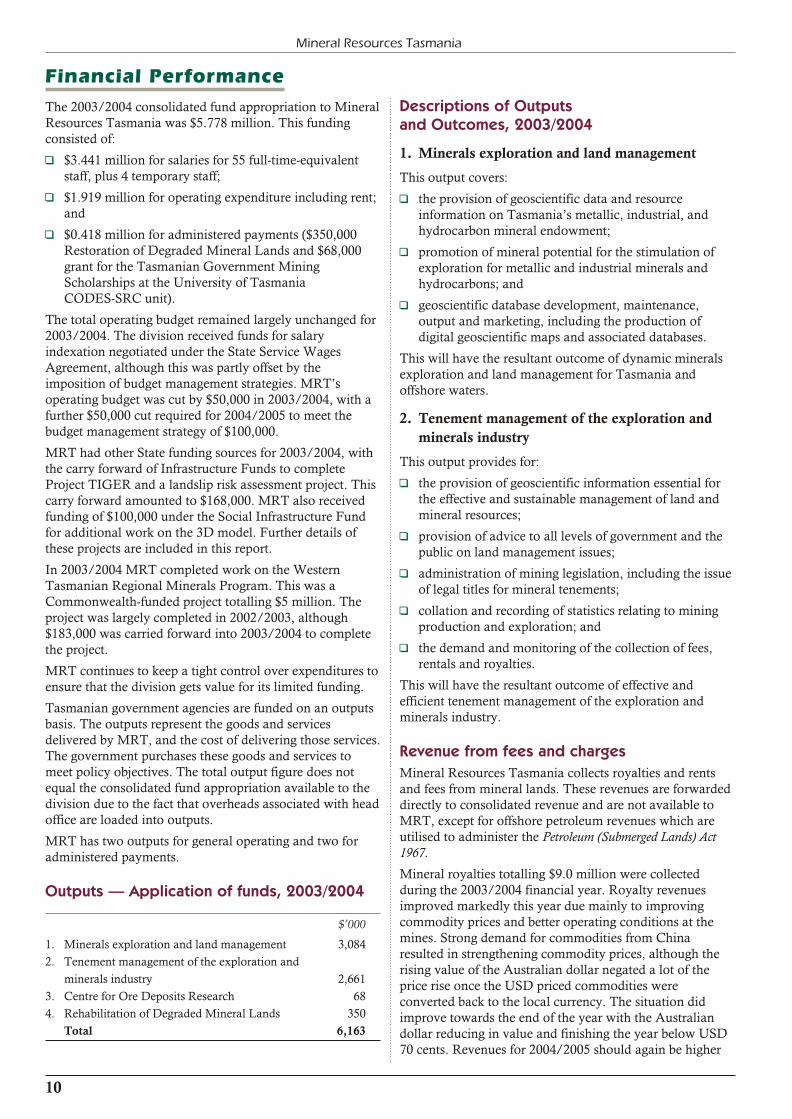
Outputs — Application of funds, 2003/2004
$’000
1. Minerals exploration and land management 3,084
2. Tenement management of the exploration and
minerals industry 2,661
3. Centre for Ore Deposits Research 68
4. Rehabilitation of Degraded Mineral Lands 350
Total 6,163
Descriptions of Outputs and Outcomes, 2003/2004
1. Minerals exploration and land management
This output covers:
1 the provision of geoscientific data and resourceinformation on Tasmania’s metallic, industrial, andhydrocarbon mineral endowment;
1 promotion of mineral potential for the stimulation ofexploration for metallic and industrial minerals andhydrocarbons; and
1 geoscientific database development, maintenance,output and marketing, including the production ofdigital geoscientific maps and associated databases.
This will have the resultant outcome of dynamic mineralsexploration and land management for Tasmania andoffshore waters.
2. Tenement management of the exploration and
minerals industry
This output provides for:
1 the provision of geoscientific information essential forthe effective and sustainable management of land andmineral resources;
1 provision of advice to all levels of government and thepublic on land management issues;
1 administration of mining legislation, including the issueof legal titles for mineral tenements;
1 collation and recording of statistics relating to miningproduction and exploration; and
1 the demand and monitoring of the collection of fees,rentals and royalties.
This will have the resultant outcome of effective andefficient tenement management of the exploration andminerals industry.
Revenue from fees and charges
Mineral Resources Tasmania collects royalties and rentsand fees from mineral lands. These revenues are forwardeddirectly to consolidated revenue and are not available toMRT, except for offshore petroleum revenues which areutilised to administer the Petroleum (Submerged Lands) Act1967.
Mineral royalties totalling $9.0 million were collectedduring the 2003/2004 financial year. Royalty revenuesimproved markedly this year due mainly to improvingcommodity prices and better operating conditions at themines. Strong demand for commodities from Chinaresulted in strengthening commodity prices, although therising value of the Australian dollar negated a lot of theprice rise once the USD priced commodities wereconverted back to the local currency. The situation didimprove towards the end of the year with the Australiandollar reducing in value and finishing the year below USD70 cents. Revenues for 2004/2005 should again be higher

11
2003/2004 Annual Review
due to the resumption of operations at the Renison tinmine, and the continuing higher prices for commodities.
Individual mine reports in this review discuss productionand profitability of mining operations.
Rents and fees from mineral lands raised $0.942 million in2003/2004, which was well above budget due to asignificant upsurge in exploration licence applications.
Increased revenues for petroleum rents and fees areexpected in 2004/2005 due to a major lease holder makingtwo rental payments in that year. Revenues are thenexpected to go back to the 2003/2004 target figure.
Target Actual Target
03/04 03/04 04/05
Royalties ($,000) 7,000 8,979 9,000
Rents and Fees ($,000) 721 942 741
Rents and Fees — Petroleum ($,000) 169 231 310
Sales of Maps and Publications ($,000) 13 14 14
Royalty assessment
MRT is responsible for the collection of mineral royaltiesfrom Crown Land tenements. Royalty is not a tax but apayment to the community for the purchase ofnon-renewable resources from the State.
MRT conducts a royalty audit program to ensure tenementholders are paying in accordance with the legislation. Theaudit program mainly concentrates on the metallic mineswhich pay royalty based on net sales and profits. Metallicmines pay the vast majority of royalty revenue.
The Tasmanian royalty regime operates under two systemsdepending on the type of resource recovered. Companiesproducing a metallic mineral or coal pay under a two-tiered
regime where royalty is paid on the net sales and the profitfrom a mine. Royalty on the recovery of non-metallicminerals on Crown leases is set on a per cubic metre or pertonne basis.
The two-tiered metallic and coal royalty consists of an advalorem percentage payable on net sales, and aformula-based percentage of profits. This system requiresmining companies to pay a fixed percentage of sales inroyalty for ore extracted, and allows the community tobenefit further in good times when a company is making aprofit.
Following negotiations with the mining industry, newroyalty rates were approved in August 1997, with theregime taking effect from 1 July 1997. Non-metallic ratesincreased from $1.00 per cubic metre to $1.20 per cubicmetre, while it was agreed that metallic mineral and coalroyalties would be increased incrementally over a numberof years to the current full level.
The ad valorem rate for net sales is 1.6%. The profitcomponent of the royalty regime is calculated via anexponential formula which increases the percentage ofprofit royalty paid as the mine’s profit increases.
A royalty cap of 5% of net sales has been set so thathigh-cost, short-life mines are not discriminated against.
Mining companies that expand into downstreamprocessing to produce a near pure specific metal can applyto the Treasurer to receive a 20% rebate on royaltiespayable. Companies that produce gold doré can apply toclaim a 10% rebate on royalties.
The Treasurer has the discretion to increase the gold dorérebate to 20% depending on criteria such as the magnitudeof investment undertaken and the benefit to the Tasmanianeconomy from the investments.
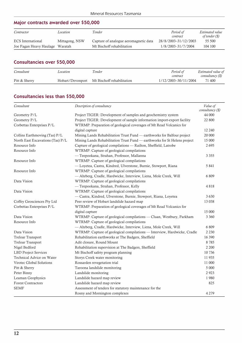
Major contracts awarded over $50,000
Contractor Location Tender Period of Estimated value contract of tender ($)
ECS International Mittagong, NSW Capture of analogue aeromagnetic data 28/8/2003–31/12/2003 55 500
Joe Fagan Heavy Haulage Waratah Mt Bischoff rehabilitation 1/8/2003–31/7/2004 104 100
Consultancies over $50,000
Consultant Location Tender Period of Estimated value of contract consultancy ($)
Pitt & Sherry Hobart/Devonport Mt Bischoff rehabilitation 1/12/2003–30/11/2004 71 400
Consultancies less than $50,000
Consultant Description of consultancy Value of consultancy ($)
Geometry P/L Project TIGER: Development of samples and geochemistry system 44 000
Geometry P/L Project TIGER: Development of sample information import-export facility 22 800
Corbettas Enterprises P/L WTRMP: Preparation of geological coverages of Mt Read Volcanics for
digital capture 12 240
Collins Earthmoving (Tas) P/L Mining Lands Rehabilitation Trust Fund — earthworks for Balfour project 20 000
North East Excavations (Tas) P/L Mining Lands Rehabilitation Trust Fund — earthworks for St Helens project 15 000
Resource Info Capture of geological compilations — Railton, Sheffield, Latrobe 2 695
Resource Info WTRMP: Capture of geological compilations
— Teepookana, Strahan, Professor, Mallanna 3 355
Resource Info WTRMP: Capture of geological compilations
— Loyetea, Castra, Kindred, Ulverstone, Burnie, Stowport, Riana 5 841
Resource Info WTRMP: Capture of geological compilations
— Ahrberg, Cradle, Hardwicke, Interview, Liena, Mole Creek, Will 6 809
Data Vision WTRMP: Capture of geological compilations
— Teepookana, Strahan, Professor, Kelly 4 818
Data Vision WTRMP: Capture of geological compilations
— Castra, Kindred, Ulverstone, Burnie, Stowport, Riana, Loyetea 3 630
Coffey Geosciences Pty Ltd Peer review of Hobart landslide hazard map 13 038
Corbettas Enterprises P/L WTRMP: Preparation of geological coverages of Mt Read Volcanics for
digital capture 15 000
Data Vision WTRMP: Capture of geological compilations — Cluan, Westbury, Parkham 3 360
Resource Info WTRMP: Capture of geological compilations
— Ahrberg, Cradle, Hardwicke, Interview, Liena, Mole Creek, Will 6 809
Data Vision WTRMP: Capture of geological compilations — Interview, Hardwicke, Cradle 2 230
Treloar Transport Rehabilitation earthworks at The Badgers, Sheffield 16 390
Treloar Transport Adit closure, Round Mount 8 785
Nigel Bedford Rehabilitation supervision at The Badgers, Sheffield 2 200
LBD Project Services Mt Bischoff safety program planning 10 736
Technical Advice on Water Storys Creek water monitoring 11 935
Virotec Global Solutions Rossarden revegetation trial 11 000
Pitt & Sherry Taroona landslide monitoring 5 000
Peter Binny Landslide monitoring 2 923
Leaman Geophysics Landslide hazard map review 1 980
Forest Contractors Landslide hazard map review 825
SEMF Assessment of tenders for statutory maintenance for the
Rosny and Mornington complexes 4 279
12
Mineral Resources Tasmania
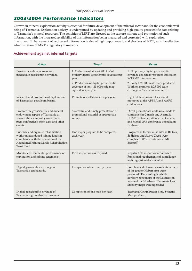
2003/2004 Performance Indicators
Growth in mineral exploration activity is essential for future development of the mineral sector and for the economic wellbeing of Tasmania. Exploration activity is underpinned by updating and providing high quality geoscientific data relatingto Tasmania’s mineral resources. The activities of MRT are directed at the capture, storage and promotion of suchinformation, with the increased availability of this information being measured and correlated with explorationinvestment. Enhancement of geohazard information is also of high importance to stakeholders of MRT, as is the effectiveadministration of MRT’s regulatory framework.
Achievement against internal targets
13
2003/2004 Annual Review
Action Target Result
Provide new data in areas withinadequate geoscientific coverage.
1. Collection of at least 200 km2 ofprimary digital geoscientific coverage per year.
2. Production of digital geoscientificcoverage of ten 1:25 000 scale mapequivalents per year.
1. No primary digital geoscientificcoverage collected; resources utilised onWTRMP interpretation.
2. Forty 1:25 000 scale maps produced.Work on seamless 1:25 000 scalecoverage of Tasmania continued.
Research and promotion of explorationof Tasmanian petroleum basins.
Promote one offshore area per year. Eight offshore areas released andpromoted at the APPEA and AAPGconferences.
Promote the geoscientific and mineralendowment aspects of Tasmania atvarious shows, industry conferences,press conferences, open days and otherevents.
Successful and timely presentation ofpromotional material at appropriatevenues.
Direct promotional visits were made tocompanies in Canada and Australia.PDAC conference attended in Canadaand Mining 2003 conference attended inBrisbane.
Prioritise and organise rehabilitationworks on abandoned mining lands incompliance with the operation of theAbandoned Mining Lands Rehabilitation Trust Fund.
One major program to be completedeach year.
Programs at former mine sites at Balfour, St Helens and Storys Creek werecompleted. Work continues at MtBischoff.
Monitor environmental performance onexploration and mining tenements.
Field inspections as required. Regular field inspections conducted.Functional requirements of complianceauditing system documented.
Digital geoscientific coverage ofTasmania’s geohazards.
Completion of one map per year. Four landslide hazard classification maps of the greater Hobart area wereproduced. The existing landslideadvisory zone maps of the Launcestonarea and the Northwest Tasmania LandStability maps were upgraded.
Digital geoscientific coverage ofTasmania’s groundwater resources.
Completion of one map per year. Tasmania Groundwater Flow SystemsMap produced.

Achievement against external targets
Target 2003/2004 result 2002/2003
Increase exploration expenditure and maintainlevel at 2% of total Australian explorationexpenditure.
Exploration expenditure increased to $7.6 millionin 2003/2004, with Tasmania’s share of Australian expenditure increasing to 0.97%.
0.59%
Increase level of exploration expenditure to aminimum of $30 million per financial year.
$4.3 million
Obtain an increase in the area held underExploration Licence.
Area held under All Minerals and Non-metallicExploration Licences increased to 10 063 km2. Afurther 60 826 km2 is held for onshore oilexploration.
8391 km2
Obtain an increase in the number of Exploration Licences granted.
The number of Exploration Licences heldincreased to 141.
127
Obtain an increase in the percentage of Strategic Prospectivity Zones (SPZ) held under EL’s.
The percentage of land in SPZ areas held underEL’s increased to 9230 km2.
6943 km2
Mineral Resources Tasmania — Legislation and Committees
Legislation administered
1 Mineral Resources Development Act 1995
1 Mining (Strategic Prospectivity Zones) Act 1993
1 Petroleum (Submerged Lands) Act 1982
1 Iron Ore (Savage River) Deed of Variation Act 1990
Statutory bodies
1 Nomenclature Board
Non-statutory bodies
1 Ministerial Council for Mineral and Petroleum Resources (MCMPR) and associated Standing Committee of Officials,Task Forces and Working Groups
1 ABS Mining Statistics User Advisory Group
1 Australian Society of Exploration Geophysicists Data Standards Committee
1 Australian Urban Regional Information Systems Association (AURISA)
1 Chief Government Geologists Committee
1 CODES-SRC Advisory Board
1 DPIWE Application Assessment Panel
1 Evaluation of Geoscience Australia’s Geoscience Survey and Research Activities
1 Government Geoscience Information Policy Advisory Committee and associated Working Group
1 Crown Land Assessment Working Group
1 Groundwater Coordination Committee
1 Inter-Departmental Oceans Policy Working Group
1 Land Information Coordination Committee (LICC)
1 LICC Sub-committee — The List Management Advisory Group
1 Mineral Exploration Working Group
1 Mineral Resources Industry Advisory Panel
1 Mining Heritage Committee
1 National Groundwater Committee
1 Tasmanian Statistical Advisory Committee
14
Mineral Resources Tasmania
15
2003/2004 Annual Review
Mineral Resources Tasmania — Branch Activities, 2003/2004
Metallic Mineralsand Geochemistry
During 2003/2004 the Metallic Minerals andGeochemistry Branch was involved in a number of projects and programs. Emphasis was placed on preparinggeological information for digital capture and upgrading ofdatabases for delivery of data via the world-wide web.
Western Tasmanian Regional MineralsProgram (WTRMP)
Planning of projects was done in conjunction withCommonwealth Government, industry and MRTpersonnel.
Two reports on field checking of features in theaeromagnetic and radiometric data in northwest Tasmaniawere close to completion at year end.
The study to recompile and synthesise the geology ofTasmania’s main mineralised rock suite, the Mount ReadVolcanics (MRV), was completed, with the presentation ofa general geological legend for the MRV and a critique onthe 1:25 000 scale geology with suggestions for amendment of rock unit assignments. The way was prepared forcompletion of the upgrade of the geology of the MRV by acontract geologist preparing information from theremaining areas for digital capture.
The final two reports on the mineral potential of Devoniangranite aureoles were received from consultants. Thesefocussed on areas in northwest and central north Tasmania.
The interpretation of data from the HyMap hyperspectralremote sensing mineral survey of the Queenstown regionwas completed by the CSIRO following ground validationof mineral mapping interpretations by CSIRO and MRTpersonnel, partly in conjunction with a Ph.D. student fromCODES-SRC.
Upgraded data and images from the Pacrim II radar survey of part of western Tasmania were received from NASA.
Three-dimensional geological modelof Tasmania
The then Deputy Premier launched the three-dimensionalgeological model and prospectivity analysis of Tasmaniaon 17 October 2003. A regional study of this magnitudeand detail was a world’s first. Following minor correction,the model was distributed on 1 April 2004.
The model involved the input of mine-scale data from themining industry. The project was co-ordinated by the
Predictive Mineral Discovery Cooperative Research Centre (pmdCRC) based at the University of Melbourne, whichsubcontracted Geoinformatics Exploration Limited toproduce the visual model based on information supplied by pmdCRC and MRT personnel.
The project established a new benchmark forindustry-government co-operation and involved integration of regional-scale data, provided mainly by MRT, withdetailed information from the major mines, generouslyprovided by mine management to be incorporated in themodel. The Centre for Ore Deposit Studies (CODES) at the University of Tasmania was contracted to produce digitalmaps of volcanic associations and rock alteration mineralassemblages to be incorporated in this model.
The model was extensively promoted during the latter partof the year and has received wide praise for itscomprehensiveness and innovation.
Geoscientific data generation
The generation of new primary geoscientific data wassuspended to enable focus on the capture of existing datainto digital formats, and to enable completion of thethree-dimensional geological model and WesternTasmanian Regional Minerals Program projects.
Fifty geological map sheets were prepared for digitalcapture by the Branch during the year (Devonport,Latrobe, Railton, Sheffield, Calder, Yolla, Studland,Mallanna, Professor, Bellinger, Strahan, Kelly,Teepookana, Liena, Mole Creek, Montana, Cluan,Deloraine, Westbury, Parkham, Bridgenorth, Burnie,Stowport, Riana, Loyetea, Ulverstone, Kindred, Castra,Cradle, Will, Goulds, Collingwood, Loddon, Bridport,Tam O’Shanter, Waterhouse, Tomahawk, Lyme Regis,Musselroe, Naturaliste, Eddystone, Ansons Bay, TheGardens and Binalong). Of these, 31 sheets were preparedby a contract geologist working on a WTRMP project. TheYolla and Calder sheets included limited field checking and incorporation of interpretations of WTRMP geophysicaldata, while the Studland sheet included geologicalinterpretation of the geophysics.
Branch members are involved in a co-operative project with Geoscience Australia and an expert consultant to define the mineral potential of Tasmanian granites and surroundingrocks as part of a broader study of eastern Australia.
During 2003/2004 Mineral Resources Tasmania consisted of five branches: Metallic Minerals and Geochemistry;Industrial Minerals and Land Management; Information Systems and Geophysics; Data Management; and Royalty,Finance and Administration.
Because of the integrated nature of the branches, outputs provided under the banner of the Tasmanian Geological Surveyare contributed to by staff of all branches.
Database development
The main work of the branch for the year involved thedevelopment of database structures for the TIGER Systemand the verification and capture of data for incorporation in the new system.
A total of 20,386 records in the drill holes module wereverified, completing quality assurance of the database.There are 743 records that lack references and were notverifiable.
The TASROK and ROKSTOR databases for MRT rocksamples were merged into a database of over 30,000 MRTsamples. Migration into an Oracle database andpreparation of business rules have been advanced.
Approximately 25% of the mineral deposits database hasbeen verified and corrections have been made to thedatabase structure.
Geochemical data have been successfully migrated to theOracle platform.
Information for the Australian Spatial Data Dictionary was updated.
Core library
A successful application was made for Capital InvestmentProgram funding to extend the Mornington core library in2004/2005.
The level of usage of the core library continued, with 52visits during the year to inspect drill core.
Large volumes of core continue to be sent by companies tothe Mornington core library. At one stage, there was apotentially serious situation with major amounts of corefrom the Renison Bell and Hellyer mine leases possiblyneeding accommodation at Mornington. Core transferfrom Renison Bell was underway when the sale of the mine was announced. Following discussions with the newowners the core was returned at their expense.
The core library supervisor again visited the West Coast toinspect core that will be transferred to MRT in the future.
Mineral exploration and otherpromotional activities
Promotional missions were conducted to Perth in June2003 and to Sydney and Brisbane during May 2004.Promotional displays were held at the Annual Meeting ofthe Prospectors and Developers Association of Canada(PDAC) in Toronto in March 2004, and at the Mining 2003trade show in Brisbane in November 2003. Pre- andpost-convention visits were made to companies in Torontoand Vancouver as part of an Australian delegation and also with a Tasmanian team.
These activities were well received and resulted inapplications for exploration licences.
There was also evidence that the three-dimensionalgeological model and prospectivity analysis of Tasmania,and data generated by the Western Tasmanian RegionalMinerals Program (WTRMP) and the TIGER Project,were stimulating exploration licence applications,especially in western Tasmania. A large number of visitors
to MRT were shown the 3-D model and displays producedrelevant to their areas. Parts of the prospectivity analysiswere incorporated in an information memorandumproduced by Intec Limited to attract joint venture partnersto conduct exploration in the Hellyer mine area.
Articles, promotional material and information on mineralprospectivity and exploration activities in Tasmania wereprepared for various specialist mining journals.
Several branch members made contributions to displaysheld at the Burnie, Hobart and Launceston shows. Inaddition, the petrologist conducted displays andpublication sales for the National GemmologicalSymposium, held in Hobart, and presented talks at schools.
A successful promotional display was held at the 24-caratGold symposium held in Hobart in June 2004.
Petrology
The petrologist supervises the petrological and lapidarylaboratories, which service internal and external clients, aswell as managing or supporting several projects anddatabases. He is also involved with projects and generalexploration administration.
The lapidary and petrology laboratories provided a total of$24,064 worth of analyses and services to the Departmentof Infrastructure, Energy and Resources (DIER) ($6,325)and external clients ($17,739). Most of this external workcannot be otherwise conducted within Tasmania.
The lapidary laboratories prepared 167 standard thinsections and 19 polished thin sections, making a totalthroughput of 186 samples. Most of these were done on anas-needed basis by the field assistant; this work was valuedat $4,460.
The technical officer for petrological services processed 313 samples by X-ray diffraction, including 175 quantitativedust analyses. He also conducted 47 soil and sizing testsand 70 optical asbestos identifications, a total of 430samples processed, valued at $19,604. About half of histime was spent preparing samples for, and operating, theXRF for the Geochemistry Section.
A total of 345 external (contract) samples were received forinvestigation, mostly by X-ray diffraction. These samplesincluded 247 for occupational health clients, 46 soils, seven construction materials, 14 industrial samples, two forensicsamples, 20 general rocks and 29 other samples. Thisexternal work came from a wide range of external sources,including the Transport and Workplace Safety branches ofDIER, Tasmania Police, Hydro Tasmania, the Department of Primary Industries, Water and Environment and othergovernment departments, the University of Tasmania (staffand students), various mining, mineral processing andmineral exploration companies, environmental andoccupational health consultants, geotechnical and soiltesting companies, the general public and miscellaneousbusinesses.
Samples studied include geological materials (constructionmaterials, mineral concentrates, ore samples, rocks, soils,sands and clays), fish products and anthropogenic materials (including forensic samples, concretes, asbestos sheeting,
16
Mineral Resources Tasmania

17
2003/2004 Annual Review
industrial materials, dusts, acid drainage, etc). Forensicstudies continued with work for Tasmania Police.
The soil laboratory has been closed due to accommodationpressures at Rosny. The equipment has been redistributedbetween various laboratories, allowing soil investigations to continue.
The petrologist, as official radiation safety officer, hasoverseen some radiation storage, X-ray equipment safetyinspections and other safety issues. Laboratory safety audits are underway.
The petrologist is helping update the Tasmanian gemstonebooklet and posters, and update the list of designatedfossicking areas. The Catalogue of Mineral Occurrences inTasmania has been updated. The petrologist also handlesnumerous public and commercial enquiries on all mannerof mineral, mining and rock-related matters, particularly inregard to mineral locations and identification, occupational health issues, and mine locations. The petrologist is alsocurator for MRT’s rock and mineral specimens.
Geochemical laboratory
During 2003/2004 the laboratory was staffed by a seniorchemist and a technical officer. A geologist/geochemistand another technical officer provided part-time assistance.Although our sample preparation technician does most ofthe water analyses, the laboratory is undermanned due tothe absence of a specialist chemist/technician ininstrumental/wet chemistry. Absence or leave of anypersonnel severely limits the ability of the laboratory tosupply anything other than provisional results.
The laboratory generates the chemical/geochemical datanecessary to maintain MRT’s databases. A total of 324samples, consisting of 154 water samples, 154 rocks and 16minerals or products, were submitted for 8,595 individualdeterminations during the year.
A total of 395 samples were assayed for 7,201 individualdeterminations. The 395 samples analysed comprised 128waters, 126 rocks and 141 minerals or products.
A major upgrade to the sample preparation laboratory tomeet air quality standards and OH & S requirements wassuccessfully completed early in the financial year. Tomaintain the smooth running of the upgraded samplepreparation dust extraction unit, a new enclosed motorreplaced the less protected and fused original motor. Thenew motor has resulted in further improvement due toincreased suction which has given more control over theextraction system. This has made for a safer workingenvironment with a higher level of efficiency andeffectiveness.
The use of new and improved sample boxes for storage onpallets is being progressively implemented. This will allowfor the rearrangement of stored samples and betteraccessibility.
Repair of the Leco Induction Furnace, involvingreplacement of capacitors and resistors at a cost of $2,600,has avoided purchasing a replacement instrument valued at about $45,000.
Careful operation and maintenance has kept the XRF unitand AA instruments operating in a stable condition
throughout the year. Further updating of the hardware andWindows-based software operating system has alloweddata generated by the XRF to be better incorporated intothe Tiger System databases. Apart from saving time on theoperation of the unit and data processing, this will furtherlimit the possibility of data transposition errors. The datafrom the XRF, Laboratory Register of Chemical Analysesand water analyses is now available in Excel format. Thisallows new data to be made freely accessible through theTiger System.
Other activities
1 Meetings of the Future Together Core Group andassociated groups were attended during the year.
1 Four staff members are on safety and workplaceharassment committees.
1 Branch members were involved in planning, presentingpapers and leading excursions for the AustralianGeological Convention held in Hobart in February2004.
1 A branch member is convener of a committee to prepare authority tables for the National Geodata Model, aworking group established under the GovernmentGeologists Information Policy Advisory Committee. Ameeting of the group was held in Melbourne in June2004.
1 Three geologists attended the international 24-carat Goldworkshop held at Wrest Point in June 2004.
1 Mineral exploration report and exploration performance assessments were carried out as needed, as waspreparation of promotional leaflets for ExplorationRelease Areas. Particular attention was placed onmonitoring performance on exploration licences.
1 The petrologist presented a poster paper at theAustralian Geological Convention in Adelaide in July2003.
1 Numerous meetings were held with industry andCODES-SRC, and presentations were given at theannual meeting of the Tasmanian Minerals Council onthe three-dimensional geological model of Tasmania.
1 Many requests for information on geology, mineralresources, minerals and related matters were receivedand dealt with promptly.
1 Meetings of the Tasmanian Statistical AdvisoryCommittee were attended during the year.
1 Safety audits have been carried out in the laboratoriesand core library, including the safe storage ofradioactive mineral samples. Work was done inupdating safety manuals.
1 A geologist attended the Ishihara granite symposium inSydney in July 2003.
1 A business review of the Exploration Release Areaprocess was prepared.
1 Training sessions on the 3-D model and FracSISsoftware were attended by geologists, and staff members undertook other self development training during theyear.

18
Mineral Resources Tasmania
Industrial Minerals andLand Management
This branch is responsible for the investigation andpromotion of industrial minerals, including coal andhydrocarbons; the management of mineral tenements, landaccess issues and environmental control of explorationactivity; and the protection of mining heritage. It is alsoresponsible for providing information for the managementof groundwater resources and geohazards, especially landstability.
Strategic Prospectivity Zones
Strategic Prospectivity Zones (SPZ) cover 25 200 km2 or37% of Tasmania. The areas in each SPZ occupied bymining tenements at the end of June 2004 are shownbelow.
Metallic Non-metallic
SPZ Area Occupied Area Occupied
(km2) (%) (km2) (%)
Adamsfield 69.7 94.58 0.0 0.0
Arthur 566.1 51.10 310.3 28.01
Balfour 550.0 14.18 475.1 12.14
Beaconsfield 26.7 99.98 0.0 0.0
Cape Sorell 364.0 26.33 0.0 0.0
Mount Read 1909.8 26.63 107.6 1.50
North East 3393.0 34.95 320.5 3.30
Zeehan/Waratah 1000.7 54.56 137.3 7.49
(7880.0) (1350.8)
In comparison to last year’s occupancy for metallicminerals, the Mount Read SPZ has increased from 16.73%to 26.63%, the North East SPZ has increased from 31.27%to 34.95%, and the Zeehan /Waratah SPZ has increasedfrom 22.53% to 54.56%.
Petroleum exploration and production
Seven offshore exploration permits and one onshore permit are currently held for oil and gas exploration, a productionlicence is held over the Yolla gas/condensate field in theBass Basin, and a retention lease is held over a smallacreage adjacent to the Yolla field. No hydrocarbons areproduced in Tasmania or offshore waters, but gasproduction from the Yolla field is expected to commence in late September 2004, and from the Thylacine field in mid2006.
The production licence over the Yolla field is held by aconsortium headed by Origin Energy Resources Limitedand AWE Petroleum Limited. The consortium was granted a renewal of the retention lease in October 2001, and aProduction Licence was subsequently granted in April2003. The BassGas project to develop the Yolla fieldinvolves construction of a production platform and anundersea pipeline to a processing plant onshore Victorianear Lang Lang. The project is expected to supply around10 per cent of Victoria’s natural gas needs for 15 years.MRT has been involved with discussions with the BassGasproponents, and Victorian and Commonwealthgovernment agencies, regarding the necessary approvals for the project. Yolla-4, the first of two development wells, was spudded on 18 June 2004.
Woodside Energy Limited, on behalf of the Otway Gasconsortium, has applied for a production licence for thedevelopment of the Thylacine gasfield, discovered in 2001in the Otway Basin northwest of King Island. Thylacinewill be developed concurrently with the neighbouringGeographe field, in Victorian waters, and the gas will bepiped to a processing plant near Port Campbell in Victoria.Production is expected to commence in mid 2006 to supply the growing southeast Australian gas market.
Santos Limited completed a 1336 km 2D seismic surveywest of King Island during November and December 2003.
Total Tasmanian offshore petroleum explorationexpenditure for 2003/2004 was approximately $3.278million. The total offshore petroleum explorationexpenditure for Australia in the period 1 April 2003 to31 March 2004 was $714 million. Petroleum developmentexpenditure in Tasmanian waters in 2003/2004 wasapproximately $247.6 million, mainly on the initial phasesof the BassGas development.
Collaborative studies of the Bass and Sorell basins byMRT, Geoscience Australia and the Australian School ofPetroleum (ASP) (formerly the National Centre forPetroleum Geology and Geophysics), funded by theWestern Tasmanian Regional Minerals Program, werecompleted in late 2003. These studies, listed below, haveprovided a greatly improved understanding of thepetroleum prospectivity of these basins.
1 Geology and hydrocarbon prospectivity of the Bass andDurroon basins — Interpretation report;
1 Bass and Durroon basins GIS Project;
ADAMSFIELD
MTREAD
MTREAD
ARTHUR
BEACONSFIELD
BALFOUR
ZEEHANWARATAH
CAPE SORELL
NORTHEAST
STRATEGIC PROSPECTIVITYZONES
STRATEGIC PROSPECTIVITYZONES

19
2003/2004 Annual Review
1 Review and compilation of open filemicropalaeontology and palynology data from offshoreTasmania;
1 Bass and Durroon basins, basic data compilation;
1 An audit of petroleum exploration wells in the BassBasin;
1 Regional potential field interpretation report, Bass andDurroon basins;
1 Western Tasmania regional seismic data, selectedreprocessed lines from seismic surveys T69A and T70A.
A study on aspects of the petroleum prospectivity of theSorell Basin, titled West Tasmania study: hydrocarbongeneration, migration, leakage and seepage, was completed byASP in March 2004. Palynological projects on the BassBasin were undertaken by a consultant.
Sample collections related to offshore petroleumexploration, housed by MRT and including microfossils,drill core, cuttings and sidewall core, were reshelved andcatalogued during the year. Seventy reports received during the year were indexed. Most open-file exploration reportscan now be viewed and downloaded from the MRTwebsite.
Eight offshore areas were gazetted for competitive workprogram bidding during 2004. Three of these areas in theBass Basin were re-released areas with a closing date of 30September 2004. The other areas comprised one in theOtway Basin closing on 30 September 2004, whilst threeareas in the Bass Basin and one area in the Sorell Basinclose for bids on 31 March 2005. Area T2004-5 (SorellBasin) has been nominated as a Designated Frontier Area.This measure allows an immediate uplift of 150% onPetroleum Resource Rent Tax deductions for explorationexpenditure incurred in the area. MRT staff have beenactively involved in promotion of the offshore release areas, most importantly at major industry conferences. Staff
attended the APPEA conference in Canberra and theAAPG conference in Dallas (USA) to promote the offshore acreage.
Onshore, Great South Land Minerals Limited holdsSpecial Exploration Licence 13/98 for petroleum, coveringmost of the Tasmania Basin. Renewal of this licence isunder review.
Tasmanian Natural Gas Pipeline
Alinta DTH Pty Limited acquired the Tasmanian NaturalGas Pipeline (TNGP) from Duke Energy International inApril 2004. The TNGP transports natural gas fromLongford in Victoria to Bell Bay, Hobart and Port Latta via approximately 740 km of onshore and offshore pipeline.The gas is sourced from the Gippsland Basin in Bass Straitand made available, via the TNGP, to industrial anddomestic markets in Tasmania.
The TNGP project expands the gas market in southeastAustralia. A total of 20 permanent staff is employed tooperate the pipeline, most of them based in Tasmania.
Industrial minerals
Tasmania Magnesite NL holds retention licences at ArthurRiver and Lyons River, and is actively seeking a buyer forthe licences.
Mineral Holdings Australia Ltd continues to seek a jointventure partner for the development of dolomite andlimestone resources in northwest Tasmania. The companywishes to develop an export industry based on chemical,industrial and agricultural carbonate products.
The proposal to develop heavy minerals beach sands atNaracoopa, on King Island, by Tasmanian Titanium PtyLtd has received all necessary approvals from the KingIsland Council and the Tasmanian Government. It is the
Australia
Tasmania
EX
PE
ND
ITU
RE
IN
TA
SM
AN
IAN
WA
TE
RS
($ m
illio
n)
60
50
40
30
20
10
0
TO
TA
L A
US
TR
AL
IAN
EX
PE
ND
ITU
RE
($ m
illion
)
1200
1000
800
600
400
200
0
OFFSHORE PETROLEUM EXPLORATION EXPENDITURE
19
87
19
89
19
91
19
93
19
96
19
98
19
99
20
01
20
03
company’s intention to proceed with the development of amine when funding is secured.
JJ MacDonald Pty Ltd was granted a retention licence over the Maydena/Pine Hill silica flour deposit. The companyhas made a considerable investment in defining theresource and testing the chemical and physical properties of the deposit. It is the company’s intention to apply for aMining Lease in 2004/2005.
Environmental management
The environmental monitoring of exploration programscontinued with diligence and attention to detail. Regularfield visits were made to ensure exploration work was being conducted in an environmentally responsible manner andthat rehabilitation of past sites was successful.
Compliance auditing
In response to the Regional Forest Agreement and theRPDC Land Tenure Inquiry, MRT instigated a GIS-basedproject in 1998/1999 to develop a recording system ofon-ground exploration activity. This project resulted incompliance auditing of the Mineral Exploration Code ofPractice and in the auditing of the environmental effects ofexploration in Tasmania.
As part of Project TIGER, Deloitte Touche Tohmatsuundertook a Business Process Review of the complianceauditing system in 2003. Following this review MRT hasdocumented the functional requirements required totransfer this system into the corporate TIGER System. Theconversion is dependent on resources or funding beingmade available during this financial year.
Forty-three exploration work programs were submitted toMRT for approval during the past year. Thirty-nine of these were approved, while four remain pending. Seventeen ofthese programs (including those pending) were within CAR Reserves and required comment from the MineralExploration Working Group. Members of the MineralExploration Working Group attended a number of on-sitefield inspections during the reporting period.
Table 1 summarises the types of activities approved, withina broad division of Tasmania’s land tenure system.
A total of 1.54 hectares of actual on-ground disturbancewas recorded through the year. Table 2 shows thebreakdown of the disturbance for the different land tenuresand activity types. Not all approved activities actually tookplace, and as High Quality Wilderness overlies othertenures, disturbance within this classification is accountedfor in the figures for the other land tenures.
Of the 1.54 hectares of disturbance attributed to thoseexploration activities conducted during the reporting year,1.19 hectares were rehabilitated, with the remainder to berehabilitated through the life of the licence. It is a licencecondition that all disturbances will be rehabilitated onexpiry of the licence and prior to the return of theenvironmental bond.
In Table 3 the area that has been rehabilitated is shown foreach activity and land tenure category. A percentage of thearea rehabilitated against the disturbances in the abovetable is also shown. Approximately 77.3% of the area
disturbed in the reporting period, for all land categories, has been rehabilitated.
Because of the very low environmental impact of griddingthis activity does not feature in terms of disturbanceattributed to exploration activity, although it doesconstitute a portion of the proposals and as such is still
20
Mineral Resources Tasmania
Table 1: Activities approved
Activity Car High State Crown Private HECReserve Quality Forest Land Property LandSystem Wilderness
Drill sites 17 16 42 9 13 0
Tracks (m) 1500 1500 1300 0 0 0
Costeans (m) 0 0 50 50 200 0
Helipads 2 4 2 0 0 0
Bulk samples 0 0 12 1 0 0
Table 2: Area of disturbance
Activity Car High State Crown Private HEC(ha) Reserve Quality Forest Land Property Land
System Wilderness
Drill sites 0.08 0.08 0.15 0 0.02 0
Tracks 0.30 0.30 0.62 0 0 0
Costeans 0 0 0.02 0.02 0.08 0
Helipads 0.06 0.12 0.06 0 0 0
Bulk samples 0 0 0.12 0.01 0 0
Total (ha) 0.44 0.50 0.97 0.03 0.10 0
Table 3: Area rehabilitated
Activity Car High State Crown Private HEC(ha) Reserve Quality Forest Land Property Land
System Wilderness
Drill sites 0.08 0.08 0.03 0 0.02 0
Tracks 0.30 0.30 0.48 0 0 0
Costeans 0 0 0.02 0.02 0 0
Helipads 0.06 0.12 0.06 0 0 0
Bulk samples 0 0 0.12 0.01 0 0
Total area
disturbed 0.44 0.50 0.70 0.03 0.02 0
Total area
rehabilitated 0.44 0.50 0.97 0.03 0.10 0
Percentage of
overall disturbance
rehabilitated 100 100 72 100 20 0
Table 4: Disturbance and rehabilitation over three years
Year Car Reserve State Crown Private HEC TotalSystem Forest Land Property Land
Disturbance (ha)
2001/2002 0.42 0.32 0.05 0.16 0.05 1.00
2002/2003 0.07 2.30 0.25 0.02 0.02 2.66
2003/2004 0.44 0.97 0.03 0.10 0 1.54
Total disturbance 0.93 3.59 0.33 0.28 0.07 5.20
Rehabilitated (ha)
2001/2002 0.21 0.32 0.05 0.16 0.05 0.79
2002/2003 0.07 2.30 0.25 0.02 0.02 2.66
2003/2004 0.44 0.70 0.03 0.02 0 1.19
Total rehabilitated 0.72 3.32 0.33 0.20 0.07 4.64
Percentage of
overall disturbance
rehabilitated 77.4 92.5 100 71.4 100 89.2
21
2003/2004 Annual Review
noted. A total of 58.2 line kilometres of gridding wasundertaken in the year, with 51.2 km in CAR ReserveSystem areas, 5 km on Crown Land, and 2 km on privateproperty. Of this, 27.5 km of gridding was in High QualityWilderness areas.
Table 4 presents running totals over the last three years ofthe area of disturbance and the area rehabilitated.
Approximately 90% of overall disturbance has beenrehabilitated. Disturbances are no longer counted as suchif:
1 no further rehabilitation work is required of theexplorer;
1 the area is taken up as a Mining Lease.
As High Quality Wilderness is an overlying layer on theabove land tenures it is treated separately (Table 5).
Table 5: Disturbance and rehabilitation, High QualityWilderness areas
Year Disturbance Rehabilitated Percentage of
(ha) (ha) overall disturbance
rehabilitated
2001/2002 0 0 NA
2002/2003 0 0 NA
2003/2004 0.50 0.50 100
Total 0.50 0.50 100
Codes of practice
The fourth edition of the Mineral Exploration Code of Practiceis a code under the Mineral Resources Development Act 1995.As specified in the Resource Planning and DevelopmentCommission ‘Inquiry into areas to be reserved under theTasmania–Commonwealth Regional Forest Agreement’,this code will be reviewed at regular intervals and issued for public comment. This review will follow the release of theReserve Management Code of Practice, providing adequateresources are made available, to ensure that both codes areconsistent. A project proposal has been submitted to fund afifth edition of the Mineral Exploration Code of Practice during the coming financial year.
The second edition of the Quarry Code of Practice was issuedin September 2000 and has been gazetted as a code underthe Mineral Resources Development Act 1995.
Mines Inspection
Several mines continued to suffer difficult economicconditions during 2003 but recovery was apparent during2004. Notably Pasminco emerged from administration asZinifex Limited, while the Renison Bell mine was acquiredby Bluestone Nominees Pty Ltd, which is to redevelop themine.
Two new operations commenced during the year.Allegiance Metals Pty Ltd began construction of a declineat Avebury near Zeehan, and is preparing a developmentproposal for production of nickel to commence in 2005.Cornwall Coal NL commenced production at Kimboltonnear Hamilton, initially supplying coal to the Norske Skogpaper mill at Boyer. Australian Bulk Minerals at Savage
River continued to investigate the potential forunderground development of the North Pit.
Leasing
Surveys of mining leases using GPS technology areroutinely carried out during inspections. The results areused to provide data to populate a geographic informationsystem which was developed in 2003. As data accumulatesit will provide a comprehensive picture of the disturbancecaused by mining and quarrying, and the effects ofsubsequent rehabilitation. Site plans can also be generatedand supplied to operators to form the basis of mining plansfor development applications. Discrepancies between leaseposition and the actual pit location can be recognised andlease adjustments recommended.
Instructions were issued to stop work at an unregulatedsand pit adjacent to a farm dam at South Arm and twogravel pits at Dorset. Liaison with councils resulted in theclosure and rehabilitation of an unregulated sand pit on theforeshore near Marrawah, and a gravel pit on King Island.A dispute between neighbours affected by road traffic froma pit near Sheffield exposed problems with the regulation of Level 1 permits when production rates increase.
Tailings dams
Provisions for the safety of tailings dams have beenresolved. Amendments to the Water Management Act 1999were passed by Parliament in 2003 and the regulationspromulgated in 2004. Approval for larger dams is requiredunder the Environmental Management and Pollution ControlAct 1994; these must incorporate design, safety andoperational requirements under the Water ManagementAct. MRT is involved in dam operations throughrehabilitation and mining lease provisions.
Planning issues
Submissions were drafted for planning schemes which were under review.
1 At Clarence submissions focussed on protection ofexisting resources at the Flagstaff Gully quarry andaccess to known sand resources at Llanherne.
1 At West Tamar, a submission focussed on excessivelyonerous information requirements for extractiveindustry approval applications.
An objection was made to a proposed subdivision close tothe Flagstaff Gully quarry which resulted in modificationsto the development proposal.
MRT has been providing the mineral prospectivity mapseries to council planners under exchange of informationprovisions of the partnership agreements.
Rehabilitation works
Mine rehabilitation was carried out by MRT at abandonedalluvial tin mines near St Helens and Balfour, and at gravelpits near Sheffield. Shaft protection programs were carriedout at Oakleigh Creek, Round Mount and Mt Bischoff, and weed control was undertaken at the Queensbury mine.Work was funded by the Rehabilitation of AbandonedMining Lands Trust Fund. A detailed report is providedlater in this Review.
The site of the historic Mt Bischoff mine is degraded andacid drainage emissions affect some twenty kilometres ofthe Arthur River downstream. A Commonwealth grantfrom RiverWorks Tasmania, administered by MRT, wasused to investigate the environmental impacts of theBischoff workings, and to recommend and carry out aninitial phase of drainage control. Wet conditions caused the drain construction to be interrupted in the winter months of 2003, with work being completed during 2004.
Savage River Rehabilitation Program (SRRP)
The Savage River Rehabilitation Program (SRRP) iscarried out in partnership by the Department of PrimaryIndustries, Water and Environment and Australian BulkMinerals. The strategic plan was revised to provide forincreased treatment and to reduced reliance on mitigationprojects. The major works underway are the continuedrehabilitation of ‘B’ Dump, which is being redeveloped tominimise acid generation. Planning for an alkalinityaddition trial for treatment of waste rock seepage water isproceeding.
Archaeological surveys
The Silver King mine site was surveyed for the ZeehanLandcare group. Reconnaissance surveys of the OonahSmelter, South King and Zeehan Bell workings werecarried out. Possible impacts on heritage features by theproposed rehabilitation works at Balfour were assessed.
Registry Section
The Registry Section maintains a number of miningtenement registers in hard copy and electronic format. Thesection provides advice to officers within MRT, enquirersfrom other agencies, the mining industry, the legalprofession and the general public on a wide range ofmatters associated with mining tenements and legislation.
The processing of applications for mining tenements andissue of tenement documentation continues to provide themajority of work for the section’s officers.
Close liaison is maintained with professional geologicalofficers of MRT, particularly in relation to maintenance ofthe TASXPLOR database, monitoring of explorationexpenditure, circulation of company reports, andpreparation and circulation of the TasXplorer news sheet.
The section liaises with a number of other agencies inregard to tenement applications and provides informationto field staff who monitor on-ground activity on miningtenements.
Requesting and collation of production and expenditurestatistics is an important activity carried out by the section.These statistics provide the basic data for collection ofroyalties and assessment of exploration levels.
As a result of forced budget savings it was necessary torestructure areas of the Registry Section. Changes havebeen foreshadowed in legislation to meet increases inprocessing times following a decrease in staff levels.
Exploration Release Areas are offered to potential explorers by way of the TasXplorer news sheet, which is circulated
widely within the Australian mining community. The news sheet is sent to 332 clients of MRT by facsimile (87), e-mail(63) and post (182), and is also available on the MRTwebsite. Twenty-two ERA’s were offered during the periodresulting in seven exploration licences being applied forover an area of 232 km2.
Officers of the section play a key role in maintenance of the TASXPLOR and REGIS modules within the TIGERSystem.
Mining legislation
The Mineral Resources Development Act 1995, which cameinto force on 1 July 1996, is the principal legislationrelating to the management and regulation of miningtenements in Tasmania.
Mineral Resources Tasmania provides information through Service Tasmania outlets, and forms approved under theMineral Resources Development Act 1995 are available viaMRT’s webpage or on disc.
Mining Tribunal
Under the Mineral Resources Development Act 1995, a MiningTribunal, consisting of a magistrate, has coverage of allTasmania.
The Act places an obligation on the Director of Mines toattempt to resolve disputes before there is a formal hearingbefore the tribunal. In effect this usually consists of aninformal meeting, arranged by the Registrar of Mines,between the parties.
Experience to date suggests that the dispute resolutionprocess required by the Act adequately covers mostsituations that would otherwise require formaldetermination.
Matters referred to the Mining Tribunal during the yearwere:
74178 ZZ Exploration Pty Ltd v McDermott Mining Pty Ltd — ELA 17/2003
Appeal against awarding of Exploration ReleaseArea. Appeal withdrawn.
74190 S M Coppe, D & K Lake and S Rawnsley v Lefroy Resources Ltd — ELA 28/2003
Objection lodged by landowners. No resolution todate.
74195 G Lear v Sapphire Trading Ltd — 167M/1991,EL35/2001 and EL2/2002
Dispute re interest in mining tenements. Claimwithdrawn
74199 H M Murphy v Auzex Resources Pty Ltd — ELA 41/2003
Objections lodged by owner of land found to beoutside application area. Objection withdrawn.
74201 G J Cresswell Transport Pty Ltd v M L & R D Graham — 1474P/M
Request for determination of compensation. Noresolution to date.
22
Mineral Resources Tasmania
23
2003/2004 Annual Review
74206 Hydro-Electric Corporation and Tarkine National
Coalition Inc. v Auzex Resources Pty Ltd
— ELA 19/2004
Objection lodged by holder of Crown Land Leaseand conservation action group. No resolution todate.
74207 Hydro-Electric Corporation v Providence Gold
and Minerals Pty Ltd — ELA 46/2003
Objection lodged by holder of Crown Land Lease.No resolution to date.
74208 Tarkine National Coalition Inc. v Auzex Resources
Pty Ltd — ELA 4/2004
Objection lodged to highlight natural values of areaswithin application area. No resolution to date.
74209 Tarkine National Coalition Inc. v Auzex Resources
Pty Ltd — ELA 3/2004
Objection lodged to highlight natural values of areaswithin application area. No resolution to date.
74210 Tarkine National Coalition Inc. v Index Groupof Companies Pty Ltd — ELA 33/2004
Objection lodged to highlight natural values of areaswithin application area. No resolution to date.
74211 Tarkine National Coalition Inc. v Discovery Nickel Ltd— ELA 18/2004
Objection lodged to highlight natural values of areaswithin application area. No resolution to date.
74212 M J Cocker v J J Stewart and P W Askins — ELA 29/2004
Objection lodged to highlight natural values of areaswithin application area. No resolution to date.
74213 J M Hayward v Greatland Pty Ltd — ELA 31/2004
Objection lodged by land owner. No resolution todate.
Four matters were resolved by mediation during the yearand formal hearings were conducted by the MiningTribunal for five matters.

24
Mineral Resources Tasmania
Total number of all types of exploration rightsheld as at 30 June 2004
Mining Tenement Number Area
Exploration Licences —
Category 1 (Metallic minerals) 115 5 669 km2
Category 2 (Fuel minerals) 2 75 km2
Category 3 (Construction minerals) 7 145 km2
Category 4 (Oil — onshore) 2 60 826 km2
Category 5 (Industrial minerals) 15 2 502 km2
Retention Licences —
Category 1 (Metallic minerals) 14 118 km2
Category 2 (Fuel minerals) 5 170 km2
Category 3 (Construction minerals) 5 23 km2
Category 5 (Industrial minerals) 8 30 km2
Prospectors Licences issued 99 Not applicable
Permits to explore for petroleum
under the Commonwealth Petroleum
(Submerged Lands) Act 1967 7 363 Blocks
Retention Licence under the CPSLA 1967 1 5 Blocks
Pipeline licences held under the CPSLA 1967 2
Pipeline licences held under the Tasmanian
Petroleum (Submerged Lands) Act 1982 1
Production licences held under the Tasmanian
Petroleum (Submerged Lands) Act 1982 1
Leases applied for
Product Number Area (ha)
All minerals 1 597
Dolomite 1 100
Easement 2 4
Gold 1 18
Gravel 9 100
Gravel and clay 1 5
Magnesite 1 647
Peat 1 9
Sand 4 61
Sand and gravel 3 249
Sand and stone 1 25
Silica 1 1
Specimens 2 38
Stone 4 65
Stone and gravel 3 17
Tin 2 126
Storage lease 1 107
Total 38 2169
Leases granted
Product Number Area (ha)
All minerals 2 60
All minerals and stone 1 11
Gold 3 532
Gravel 6 85
Nickel 1 400
Sand 2 11
Sand and gravel 1 74
Specimens 2 2
Stone 7 47
Stone and gravel 1 10
Storage lease 1 107
Tin 1 66
Total 28 1405
Total number of leases in force at 30 June 2004
Principal product Number Area (ha)
All minerals 30 19 136
All minerals and stone 6 5 709
Clay 8 92
Coal 3 6 314
Coal and stone 1 175
Copper 1 5
Dolerite 1 40
Dolomite 3 238
Easements 18 285
Gold 16 1 535
Granite 4 50
Gravel 168 3 133
Gravel and clay 2 34
Lime sand 4 219
Limestone 12 1 276
Magnesite 2 1 167
Magnetite 1 55
Nickel 1 400
Ochre 1 15
Peat 1 9
Quartzite 1 191
Sand 53 2 181
Sand and gravel 24 1 551
Sand and stone 10 322
Sandstone 5 39
Shale 3 35
Silica 5 437
Silica sand 1 20
Silica, sand and stone 1 50
Slate 3 165
Specimens 15 119
Stone 227 5 432
Stone and gravel 24 483
Storage lease 1 107
Tin 8 915
Umber 1 6
Total 665 51 940
Lease Applications, 2003/2004

25
2003/2004 Annual Review
Engineering Geology and Groundwater Section
This section provides geoscientific information for the
management of groundwater resources, waste disposal sites
and geohazards, especially land stability. By ensuring
relevant geoscientific data are available to the public and
private sectors, better land-use decisions can be made.
The section was involved in a number of projects during
the year. Enquiries from local government, other agencies
and the general public for information on both engineering
geology and groundwater continued as a prime function.
Engineering Geology
Land stability is a major issue in Tasmania and the current
property boom is placing additional calls for information
on areas throughout the State. Much of the routine work
carried out on land stability matters falls into the following
three main activities.
Geohazards database
The new landslide database (constructed in the previous
year) was designed to store much of the data relating to
land stability in Tasmania and underpins the project work
that is being done by MRT. Considerable effort went into
housekeeping tasks over the year by a working group. This
included documenting the data dictionary and developing
business rules which will be incorporated into a user
manual to be developed in the coming year. Minor fixes
and changes to the database are being documented. Data is
being routinely entered into the database and retrieved via
querying tools.
Monitored landslide program
A report on the Beauty Point landslide is currently being
prepared. This report is the first in a series on monitored
landslides that occur in northern Tasmania. The emphasis
of these reports is to collate all available information into a
single document that can be passed onto the key
stakeholders for risk assessment and management purposes.
Landslide hazard mapping program
Work is well underway on the first of a new landslip
hazard map series which aims to produce maps of the
major urban areas. These maps are based on a
methodology that has been developed over the last three
years for MRT.
The first maps for completion cover the area of the Hobart
Municipality and will include rockfall, debris flow and
deep-seated landslide hazards. MRT is working with the
Hobart City Council in partnership to ensure the maps
include knowledge of past landslips and other geological
information that is held in council files. Such knowledge
underpins the hazard map methodology and ensures a
robust depiction of the potential hazards for the area.
A seminar outlining the project, and inviting feedback, washeld in Launceston and Hobart. Feedback received wasencouraging and has helped shape the final output.
Groundwater
Groundwater is a precious resource in Tasmania thatcontributes considerably to the prosperity of the State byunderpinning various forms of primary industry. Asdemand for water increases, careful management isrequired to ensure long-term sustainable use and to preventcontamination. Inappropriate use of groundwater is leading to salinity problems on farmland in some parts ofTasmania, while groundwater contamination associatedwith various forms of land use is a continuing problem.
State Groundwater Coordinating Group
While the legislative responsibility for groundwatermanagement belongs to the Department of PrimaryIndustries, Water and Environment (DPIWE), much of the skill base and data relating to groundwater reside inMineral Resources Tasmania. The State GroundwaterCoordinating Group meets regularly to ensure personnel inboth departments are informed of all activities and that atruly co-ordinated approach to water management can beachieved.
An MRT hydrogeologist represents Tasmania on theNational Groundwater Committee (NGC). During the lastyear, the NGC has organised two major workshops, one on Groundwater Dependent Ecosystems (GDE) and the otheron future research needs for integrated surface andgroundwater management. As a result of this work, twopapers; Report on the national workshop on the groundwaterdependent ecosystems and Knowledge gaps for groundwaterreforms were published. MRT was involved with DPIWE in undertaking a preliminary desktop study of GDE inTasmania. A successful groundwater school was organisedin Hobart in November.
Four Commonwealth Government-funded salinity projectsand one wastewater reuse project commenced during theyear. MRT provided supervision, technical advice and data to these important initiatives.
Groundwater monitoring
MRT manages a monitoring network of 34 boreholesthroughout Tasmania, with routine sampling every sixmonths. An ongoing process of upgrading the networkcontinued with the deployment of new data recorders. Theinformation collected provides baseline data to enablelong-term trends in water quality and quantity to beanalysed. A review of the network was completed duringthe year to allow informed management decisions to bemade about the network. The report includes a summary of the results of fourteen years of monitoring activity,including trends in water levels and chemistry.
Groundwater maps
Work on the 1:500 000 scale map of Tasmaniangroundwater flow systems was completed in conjunctionwith DPIWE. The map and accompanying report provideinformation critical for the future management of thedryland salinity process in Tasmania under the NationalAction Plan program. Maps at 1:250 000 and 1:100 000scale were prepared to draft standard summarising the

hydrogeology of Tasmania. These maps, when published,will represent the first synthesis of groundwater knowledgeof the area and are, in part, being produced for localcouncils under the partnership agreements.
Groundwater database
The groundwater database, when fully functional, will be amajor asset for water management in Tasmania.Unfortunately there is still a considerable amount of workthat is required to sort out issues associated with migrationand design. Queries of the database are being maderoutinely to support project work being undertaken byMRT, and some data can be accessed via the internet. Thisis helping to provide timely information to members of thepublic.
Driller’s reports
Drillers are required to submit reports of groundwaterinvestigations on a form that was recently redesigned forthis purpose. The completed forms are checked and entered into the database by MRT staff.
Groundwater quality
Groundwater quality protection issues associated with anumber of wastewater reuse schemes continued to form animportant element of the section’s activities. This includedadvice on the potential affects on groundwater by thismethod of irrigation. The section also provides advice ongroundwater issues relating to mining tenements.
Information Systemsand Geophysics
The main activities of the Information Systems andGeophysics Branch in the 2003/2004 year were:
1 Maintenance and development of the TIGER(Tasmanian Information on Geoscience andExploration Resources) System;
1 Maintenance and development of RIMS (RoadInformation Management System);
1 Undertaking a Business Process Review of MRT’sactivities; and
1 IT related training of MRT staff.
The branch also provided geophysical services and adviceto MRT and our clients, and computer and networksupport for MRT.
The branch is structured to reflect the functions needed toachieve the outcomes required by MRT and has Project,Operations and Geophysics sections. At 30 June there wasone fixed-term staff member in the Project Sectionundertaking the MRT Business Process Definition Projectand five permanent systems support staff in the OperationsSection. The systems support staff are deployed within thefunctional areas of PC and network operations or databaseand TIGER System support. One other permanent staffmember supports the Road Information ManagementSystem (RIMS). The branch manager is also responsible for geophysical activities.
Major branch achievements during the year included:
1 completion of the geophysical aspects of the WesternTasmanian Regional Minerals Program;
1 a successful transition from project-based developmentof the TIGER System;
1 migration of datasets to the TIGER System;
1 release of two new versions of the RIMS software;
1 building an increased skills-base for information systems staff;
1 a continued high level of use of the MRT website;
1 implementing updated project management guidelineswithin MRT;
1 one-on-one training for project proponents and workinggroup coordinators;
1 completing a process review for a number of mineraltenement related activities; and
1 establishing an MRT Information Management Group.
Data capture
Capture of metadata summarising technical documentsrelating to exploration continued throughout the year, with119 new summaries entered and 222 summaries updated.In addition to internet searching of the summaries ofopen-file technical documents held by MRT, all open-filedocuments relating to onshore or offshore exploration andopen-file MRT publications can be viewed or downloadedin full over the internet.
All mineral exploration reports are now required to be inthe national standard format for digital reporting.Compliance with the report format at initial lodgement isnow in excess of 95 per cent. This has reduced the timebetween receipt of reports and completion of theconversion to a web-viewable format. Consultation withand assistance to stakeholders to ensure close compliancewith the data formats detailed in the national guidelines has continued and has contributed to the high-level ofconformance with the guidelines.
TIGER System
Following completion of Project TIGER on 30 June 2003the TIGER System, which provides a single storageenvironment for MRT’s corporate data, entered a phase ofmaintenance and enhancement supported entirely by MRTresources. The MRT website enables access to thiscorporate data and associated metadata from anywhere inthe world with internet access.
MRT staff enter, maintain and search corporate datarelating to all aspects of MRT’s activities includingtenements, exploration reports, MRT publications,groundwater, drilling, geohazards, samples andobservations, mineral deposits and geophysics using a
26
Mineral Resources Tasmania
27
2003/2004 Annual Review
number of browser-based thin client applications accessedvia the MRT intranet. The data are delivered to clientsthrough the MRT website using customised textual andspatial searches. A number of sets of basic data can bedownloaded from the website.
An Information Management Group, that includes bothmanagement and technical staff, oversees the ongoingoperation of the Information Management System and was established as part of the transition from developmentstatus to operational status. The group receives information from a number of working groups that provide informationon issues to be resolved and define new functions for theTIGER System, as well as allocating resources inaccordance with departmental and divisional priorities.Change request and fail and fix methodologies have beenintroduced to assist the working groups with continuing the progressive migration of legacy data into the TIGERSystem, and in developing the specifications for furtherdevelopment of the system.
Data migration into the TIGER System has progressedsteadily throughout the year, and tools for final verificationand user acceptance of migrated data have been developedusing Oracle Discoverer. At the end of the year migrationactivity was centred on the samples, geochemistry andobservations module, where all rock chemistry data hadbeen migrated and migration of the rock and mineralcatalogues (TASROK) was in progress. Upgrades to thedata model and thin client applications have been requiredduring the migration to accommodate new business rulesand additional data items. New tools are being investigated for developing the browser-based forms and reports used by the thin-client applications.
Project TIGER formally closed when the Project SteeringCommittee accepted the project manager’s Project ClosureReport at the final steering committee meeting on2 October 2003. Work has continued on developing a newShort Form Data Licence Agreement, which has now beenapproved by the LICC, and on developing a Data ShareAgreement with The LIST.
IT summary
In accordance with government guidelines, MRT replacesdesktop PCs every three years and transfers the originalPCs to the Schools Program. New PCs are purchased withthe current Microsoft enterprise operating system and as aconsequence the introduction of Windows XP hascommenced following extensive testing of softwarecompatibility. The progressive migration of desktopworkstations to Office XP has now been completed.
There are four network PC servers, three of which runWindows 2000. The main PC network server has beenupgraded and is now running Netware 6.1 withapproximately 136 gigabytes of on-line storage. Windows2000 servers provide anti-virus, email, intranet and imagedelivery services to MRT staff. Files on the corporate Unixsystems are accessed from PCs using Samba software.Automatic gathering of software inventories from desktopPCs and licence metering are part of the IT infrastructure.
Two Unix systems provide corporate informationtechnology services to MRT staff. In addition there is a
Unix server dedicated to development and testing for theTIGER System, a Unix web-server for the MRT intranet,and a small Unix server used for Samba and for interimstorage and backup of scanned documents. A further twoUnix servers host the MRT website. The communicationslink to the Rosny Park building was upgraded in May 2003and the MRT website was relocated to Rosny Park tosimplify maintenance and up-loading of data to the website servers.
In addition to direct support of the TIGER System, theoperational group has provided support for many divisional information-related activities.
1 MRT is now part of a DIER-wide Microsoft Exchangemail system that allows shared calendars across thedivisions of DIER.
1 A review of MRT’s spatial data storage requirements isin progress to determine the requirements for use ofspatial data and hence the options for storage andaccess. Extensive consultation with users has enabledmuch infrequently accessed data to be archived to CDand removed from network servers withoutinconvenience to users.
1 Desktop workstations have been installed in the MRTlibrary to provide public access to on-line MRTinformation resources and to the 3D geological modelof Tasmania.
1 Information systems infrastructure has been improvedwith the installation of new switches and hubs, theinstallation of extra UPS capacity, and air conditioningand upgraded computer room security.
Extensive one-on-one and group training has been provided to users in the use of the thin client applications in theTIGER System, in spatial indexing of exploration activity,in use of Microsoft Outlook and the MRT website.Members of staff from all branches of MRT have receivedexternal training in the use of Oracle Discoverer to querythe corporate database. Information Systems staff havereceived external training or undertaken self-trainingcourses in development of applications using Oraclesoftware, and in the underlying infrastructure of theTIGER System.
The development and maintenance environments for bothRIMS and the TIGER System are co-located within MRTand this has produced overall benefits for DIER. Aresource of one full-time equivalent staff member wasdedicated to RIMS during the year for applicationmaintenance and development. Two major softwarereleases and one minor release were completed. Externalcontractors migrated the Forward Program Reports toOracle Reports. As part of the plan to move from acustom-written reporting tool, a number of other reportswere also converted to Oracle Reports. Preparations arebeing made for the use of spatial data in RIMS and for theuse of Oracle Discoverer to access the RIMS database. Asecond RIMS developer will commence in August 2004.
The MRT website continued to be well used, with anaverage monthly download volume of 15 GB and a peakmonthly download volume of 57 GB. The MRT websiteprovides a high-speed access point for clients to access theopen-file data held in the MRT corporate information

Contour and flight-path data from analogue aeromagnetic surveys undertaken between 1957 and 1966 (bottom half) have been digitisedand processed using modern digital processing techniques. The surveys were flown with 400 metre line spacing and a nominal terrain
clearance of 150 metres, both of which are significantly better than any of the more modern surveys over the same area. The reprocesseddata (top half) show structure within the dolerite-covered northeast corner of the survey area and enhance subtle features previously not
visible or not clearly seen in the more modern data.
28
Mineral Resources Tasmania

29
2003/2004 Annual Review
management system. Mapping of the structure of thewebsite is currently being undertaken in preparation formigration to a new version of the Oracle Portal software.Links to the BizTas website provide details ofTasmanian-based service providers that can provideservices to MRT clients. Open-file data within the Oracledatabase is replicated on a daily basis from the MRTcorporate information management system to the website.The website also offers Web Map Service/Web FeatureService for a restricted number of datasets. Larger datasetsstored on the file system are not suited to routinereplication and several manually triggered data updateshave been undertaken. Research into possible options forautomated replication of data stored in the file system iscontinuing. In excess of four terabytes of network attachedstorage is used to accommodate these large data volumes.
Western Tasmanian Regional Minerals Program
A reference group with an independent chairman andmembers drawn from the Tasmanian Minerals Council, the Department of Industry, Science and Resources and MRTdeveloped a series of projects to implement the geoscienceinfrastructure recommendations of the Final RegionalDevelopment Plan of the Western Tasmanian RegionalMinerals Program. The Information Systems andGeophysics Branch was responsible for the acquisition ofaeromagnetic, radiometric and airborne electromagneticdata over parts of King Island and western andnorthwestern Tasmania, and for the scanning andimplementation of internet viewing and downloading of the technical documents held by MRT. The previously released data from aeromagnetic surveys over King Island andwestern and northwestern Tasmania, and electromagneticsurveys over selected areas of western and northwesternTasmania, have been well received by the mineralexploration industry.
A new project proposal for the capture of analogueaeromagnetic data from an area adjacent to that flownunder the Western Tasmanian Regional Minerals Programwas accepted by the Commonwealth and completed thisyear. Contour and flight-path data from aeromagneticsurveys undertaken between 1957 and 1966 were digitisedand processed using modern digital processing techniques.The surveys were flown with 400 metre line spacing and anominal terrain clearance of 150 metres, both of which aresignificantly better than any of the more modern surveysover the same area. The reprocessed data show structurewithin the dolerite-covered northeast corner of the survey
area and enhance subtle features previously not visible ornot clearly seen in the more modern data.
Geophysics
The MRT website has indexes to gravity base stations, toairborne geophysical surveys for which digital data areheld, and to gravity stations available for clients. Whereapplicable the basic digital data can also be downloaded.New open-file data has been added to the website as it isreceived. Survey control point information can be easilyretrieved from The LIST after carrying out a map-basedsearch on the MRT website.
Preparation has continued for conversion of geophysicaldata from AGD66 to GDA94. Specialised software hasbeen incorporated within some of MRT’s existingFORTRAN code to assist in the conversion process.
Business Process Definition Project
A project to document and refine MRT’s businessprocesses in order to take advantage of the new corporateinformation management system (TIGER), and to reducethe risks associated with dependence on individuals,commenced at the start of the year. The major deliverableswill include documentation of revised business processesthat support MRT’s core business, better integration ofrelated activities, documentation of the processes used tocarry out this project, and training and templates for MRTstaff to maintain documentation of business processes forMRT operational and project-based work.
An initial review showed that many activities throughoutMRT are related to mineral tenements and the projectcommenced with a review of all tenement-related activities. A process review has been completed for tenementapplications, bonds, renewals, relinquishments/surrenders/ expiries, royalty collection and reconciliation, rentdemands, annual review reporting and dealings. TheExploration Release Area process has been documentedand a number of changes flagged for inclusion in theREGIS system and tenement workflows.
Current project activities include documenting tenementcompliance (new applications, bonds, tenementinspections, tenement renewals, end of tenementcompliance, tenement performance compliance andtracking), developing functional requirements for TEAMSII, and describing the existing mining lease inspectionsystem.

30
Mineral Resources Tasmania
DataManagement
The role of the Data Management Branch includes:
1 geoscientific data management;
1 tenement management services;
1 management of the Geographic Information System(GIS);
1 management of the Computer-Aided Drafting (CAD)system; and
1 provision of support drafting services.
During 2003/2004 the capture of 1:25 000 scale digitalgeological data continued. Much of this work was done aspart of the Western Tasmanian Regional Minerals Program (WTRMP) and resulted in the completion of forty wholemap areas and four part map areas throughout Tasmania:
1 twenty-one 1:25 000 scale digital geological maps innorthwestern Tasmania (Ahrberg, Bellinger, Burnie,Castra, Devonport, Hardwicke, West Heemskirk,Kindred, Latrobe, Liena, Loyetea, Mole Creek,Montagu, Railton, Riana, Sheffield, Stowport,Studland, Tewkesbury, Ulverstone, Wynyard);
1 eleven complete 1:25 000 scale digital geological mapsin southwestern Tasmania (Endeavour, Hibbs, Kelly,Loddon, Mainwaring, Mallanna, Montgomery,Professor, Strahan, Teepookana, Veridian);
1 eight complete and four part 1:25 000 scale digitalgeological maps in eastern Tasmania (Blackmans Bay,Bridgenorth, Cluan, Collinsvale, Deloraine, Liffey,Longley, Montana, New Norfolk, Parkham, QuambyBluff, Westbury).
Work on the ‘seamless’ coverage of 1:25 000 scale digitalgeology of Tasmania continues, with maintenance beingcarried out on a regular basis. Maintenance of the1:250 000 scale digital geology of Tasmania was alsocarried out on a regular basis.
As a result of remodelling of the Devonian–Carboniferousgranitoids as part of the WTRMP, a new 1:500 000 scalemap showing the major granitoids of Tasmania wasproduced. A digital 1:500 000 scale mining infrastructuremap was also completed. Hardcopy outputs of other digital data, at 1:500 000 scale, showing geology with 3Dtopographic relief, construction material deposit locationsand mineral deposit locations were also commenced.
Twenty-one draft 1:100 000 scale groundwaterprospectivity maps were completed as part of the 1:100 000scale Municipal Planning Series of maps. These maps aredesigned to provide geoscientific and tenement information to municipal councils/land use planners in an easilyunderstood format. These maps are currently subject toreview.
In association with the 1:100 000 scale Municipal PlanningSeries maps, eight draft digital 1:250 000 scale mapscovering the groundwater prospectivity of Tasmania wereproduced. These maps are also subject to review.
A digital 1:500 000 scale map of groundwater flow systemsin Tasmania was completed in partnership with theDepartment of Primary Industries, Water andEnvironment.
Four landslide hazard classification maps were produced as part of a regional landslide hazard assessment of the greater Hobart area. These maps are now subject to review. Anupgrade of the existing landslide advisory zone maps of the Launceston area was undertaken, with fourteen new mapsproduced. The six 1:25 000 scale Northwest TasmaniaLand Stability maps were also upgraded.
CAD continues to be used as a support tool for manyprojects, with 35 maps and plans and 226 tenement mapsand diagrams being produced throughout the year.
Tenement administration work included:
1 forty-eight new exploration applications processed andentered into the tenement information system;
1 twenty-four exploration tender area plans produced andentered into the tenement information system;
1 thirty-eight new mining leases processed and enteredinto the tenement information system; and
1 data on thirty-eight proposed ‘on ground’ workprograms for exploration licences was entered into theMRT information system for monitoring this type ofexploration activity.
A total of 1200 hardcopy output products of digitalgeology/tenement data was produced on demand using the division’s inkjet plotters, with 119 sets of digital geologicaldata being produced for clients.
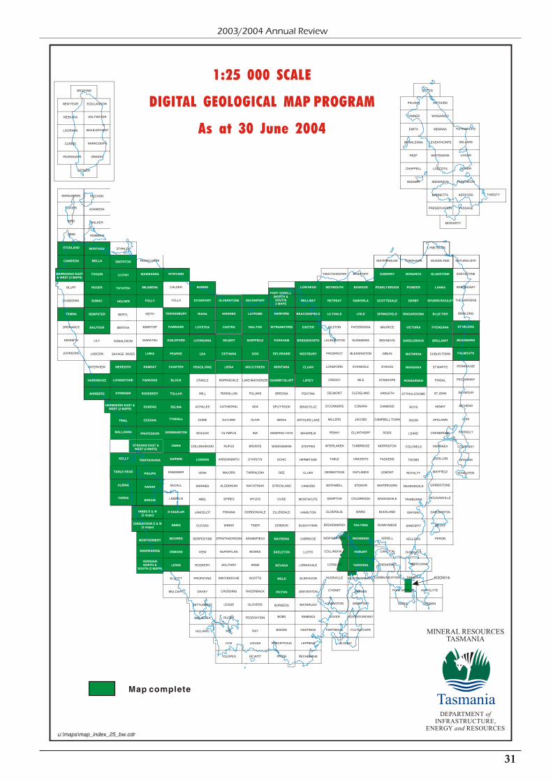
31
2003/2004 Annual Review
1:25 000 SCALE
DIGITAL GEOLOGICAL MAP PROGRAM
As at 30 June 2004
Map complete
MINERAL RESOURCESTASMANIA
DEPARTMENT ofINFRASTRUCTURE,
ENERGY and RESOURCES
Tasmania
STRAHAN EAST &WEST (2 MAPS)
BOBS
BISDEE
RAMINEA
HASTINGS
CLOUDY
DOVER
PARTRIDGE FLUTED CAPE
CYGNET
LYMINGTON GREAT BAY
ADVENTURE BAY
COMMUNICATION TARANNA
PORT ARTHUR
RAOUL
HIPPOLYTE
TASMAN
MURDUNNA
LISDILLON
MAYFIELD
BOUGANVILLE
GRINDSTONE
BICHENO
FRIENDLY
LODI
PICCANINNY
IRONHOUSE
SEYMOUR
FALMOUTH
BEAUMARIS
LYME REGIS
MUSSELROE
DUBLIN TOWN
ST MARYS
FINGAL
ST JOHN
HENRY
APSLAWN
CRANBROOK
SWANSEA
DARLINGTON
RIEDLE
PERON
GLADSTONE
LANKA
SPURRS RIVULET
BLUE TIER
PYENGANA
BRILLIANT
NATURALISTE
EDDYSTONE
ANSONS BAY
THE GARDENS
BINALONG
COLES BAY
GRAHAM
SCHOUTEN
ST HELENS
TOMAHAWK
ST PAULS DOME
ROYS
SNOW
LEAKE
COLONELS
TOOMS
ROYALTY
RAVENSDALE
TRIABUNNA
ORFORD
SANDSPIT
KELLEVIE
DUNALLEY
MONARCH
PIONEER
DERBY
RINGAROOMA
VICTORIA
SADDLEBACK
MATHINNA
MANGANA
ROSSARDEN
WATERHOUSE
MAURICE
BEN NEVIS
GIBLIN
STACKS
STANHOPE
HANLETH
DIAMOND
CAMPBELL TOWN
ROSS
MORRISTON
FADDENS
LEMONT
WHITEFOORD
WOODSDALE
BUCKLAND
RUNNYMEDE
SORELL
CARLTON
CREMORNE
OXBERRY
PEARLY BROOK
SCOTTSDALE
SPRINGFIELD
BRIDPORT
PATERSONIA
NUNAMARA
BLESSINGTON
EVANDALE
NILE
CLEVELAND
CONARA
JACOBS
ELLINTHORP
TUNBRIDGE
VINCENTS
OATLANDS
STONOR
COLEBROOK
BAINS
BLACKMANS BAY
BARNES
BOWOOD
NABOWLA
LISLE
TEA TREE
RICHMOND
HOBART
TAROONA
TAM O'SHANTER
DILSTON
LAUNCESTON
PROSPECT
LONGFORD
CRESSY
DELMONT
O'CONNORS
MILLERS
PENNY
INTERLAKEN
TABLE
DENNISTOUN
BOTHWELL
KEMPTON
ELDERSLIE
BROADMARSH
NEW NORFOLK
COLLINSVALE
LONGLEY
HUONVILLE
WEYMOUTH
RETREAT
LILYDALE
LOW HEAD
BELL BAY
BEACONSFIELD
EXETER
BRIDGENORTH
WESTBURY
CLUAN
LIFFEY
POATINA
BRADYS LO
ARTHURS LAKE
WIHAREJA
STEPPES
HERMITAGE
CLUNY
CAWOOD
MONTACUTE
HAMILTON
BUSHY PARK
UXBRIDGE
LLOYD
LONNAVALE
GLEN HUON
GEEVESTON
WATERLOO
BREONA
SPLIT ROCK
MIENA
MONPEELYATA
WADDAMANA
ECHO
DEE
STRICKLAND
OUSE
ELLENDALE
DOBSON
BURGESS
HARFORD
W FRANKFORD
PARKHAM
DELORAINE
MONTANA
QUAMBY BLUFF
MAYDENA
SKELETON
NEVADA
WELD
PICTON
LEPRENA
RECHERCHE
PRECIPITOUS
PRION
LOUISA
DE WITT
DEVONPORT
LATROBE
RAILTON
SHEFFIELD
GOG
MOLE CREEK
LAKE MACKENZIE
PILLANS
ADA
OLIVE
INA
BRONTE
D?ARCYS
TARRALEAH
WAYATINAH
WYLDS
GORDONVALE
TIGER
ADAMSFIELD
BOWES
ANNE
SCOTTS
RAZORBACK
GLOVERS
FEDERATION
RAY
COX
TOLOPEA
ULVERSTONE
KINDRED
CASTRA
WILMOT
CETHANA
LIENA
BORRADAILE
ROWALLAN
CATHEDRAL
DU CANE
OLYMPUS
RUFUS
ARROWSMITH
MAJORS
ALGONKIAN
SPIRES
POKANA
WINGS
STRATHGORDON
McPARTLAN
SOLITARY
MACONOCHIE
CROSSING
LEGGE
RUGBY
MEL
BURNIE
STOWPORT
RIANA
LOYETEA
LOONGANA
LEA
PENCIL PINE
LODDON
CRADLE
WILL
ACHILLES
DOME
GOULDS
COLLINGWOOD
VERA
WARNES
ABEL
LANCELOT
OLEGAS
SERPENTINE
VIEW
ROOKERY
PROPSTING
DAVEY
SETTLEMENT
BREAKSEA
HILLIARD
WYNYARD
TEWKESBURY
PARRAWE
GUILDFORD
PEARSE
CHARTER
BLOCK
TULLAH
SELINA
CALDER
YOLLA
TYNDALL
GORMANSTON
OWEN
DARWIN
D'AGUILAR
INNES
MOORES
OSMUND
LEWIS
ENGINEER
McCALL
LIMEKILN
ELLIOTT
MULCAHY
MAINWARING
VERIDIANNORTH &
SOUTH (2 MAPS)
KELLY
TABLE HEAD
VARNA
ALBINA
ROCKY CAPE
KEITH
BARETOP
WARATAH
MAWBANNA
MILABENA
FOLLY
LUINA
RAMSAY
PARSONS
ROSEBERY
DUNDAS
OCEANA
PROFESSOR
TEEPOOKANA
PHILIPS
SARAH
BIRCHS
MONTGOMERY
KENNETH
JOHNSONS
CUVIER
BIRD
GRIM
BLUFF
SUNDOWN
ORDNANCE
STUDLAND
CAMERON
TEMMA
LILY
LAGOON
INTERVIEW
MELLA
TOGARI
ROGER
SUMAC
DEMPSTER
BALFOUR
HARDWICKE
AHRBERG
MALLANNA
WICKHAM
STOKES
PEARSHAPE
SALTWATER
SEA ELEPHANT
NARACOOPA
GRASSY
EGG LAGOONNEW YEAR
REEKARA
LOORANA
CURRIE
MORIARTY
THIRSTY
PATRIARCHS
SELLARS
LOGAN
FISHER
PUNCHEON
KERFORD
PASSAGE
PALANA
TANNER
EMITA
WYBALENNA
REEF
CHAPPELL
BADGER
ARTHURS
WINGAROO
MEMANA
LEVENTHORPE
WHITEMARK
LOCCOTA
ANDERSON
BARRETTS
PRESERVATION
SISTER
ADAMSON
ROCHONKERAUDREN
WALKER
ROBBINS
MONTAGU STANLEY
SMITHTON
LILEAH
TAYATEA
HOLDER
BERYL
BERTHA
DONALDSON
SAVAGE RIVER
MEREDITH
LIVINGSTONE
STRINGER
HEEMSKIRK EAST &WEST (2 MAPS)
TRIAL
ENDEAVOUR E & W(2 maps)
KOONYA
HIBBS E & W(2 maps)
MARRAWAH EAST& WEST (2 MAPS)
PORT SORELL(NORTH &SOUTH)2 MAPS
u:\maps\map_index_25_bw.cdr

32
Mineral Resources Tasmania
Finance, Royalty andAdministration Branch
This branch provides the corporate support function forMineral Resources Tasmania, and is responsible for:
1 efficient royalty and fee collections and assessment sothat the system is properly managed and accounted forto the satisfaction of the Auditor-General;
1 timely provision of a financial, accounting andadministrative service to the division in conjunctionwith departmental corporate services;
1 production of publications relating to the interpretationand recording of Tasmania’s geoscientific nature,geohazards and mineral wealth, in both electronic andhard-copy form, including geological reports,promotional documents, newsletters, materials fordisplays, Exploration Release Area flyers, and otherreports and leaflets as required;
1 maintenance of the static content of the MRT website;
1 ensuring that all corporate information is kept in anorderly manner and is readily retrievable; and
1 maintenance of the MRT library collection, includingthe development and delivery of library and information services to MRT staff and members of the public.
Publications
Major publications produced during the year included:
1 The Mineral Resources Tasmania Annual Review for theyear 2002/2003.
1 Mineral exploration opportunities in Tasmania. A summaryof opportunities for mineral exploration and mineral resourcedevelopment in Tasmania — February 2004.
Twenty-one flyers promoting Exploration Release Areaswere produced.
The following reports were issued in the TasmanianGeological Record series during the year:
1999/05 — A blue amphibole occurrence from the northernArthur Lineament, by J. L. Everard.
2002/20 — Western Tasmania Regional Minerals Program.Ground truthing aeromagnetic and radiometricfeatures, northern Tasmania, by R. Poltock.
2002/21 — Western Tasmanian Regional Minerals Program— Area 3, northwest Tasmania, by D. McP. Duncan.
2003/02 — Tasmanian groundwater flow systems for drylandsalinity planning, by M. Latinovic, W. L. Matthews, C. Bastick, S. Lynch and P. Dyson.
2003/07 — The geology and groundwater resources of Nine MileBeach, eastern Tasmania, by W. C. Cromer.
2003/08 — Geology of the Mount Koonya area, by S. M. Forsyth.
2003/10 — Ground truthing of Western Tasmanian RegionalMineral Program geophysical data in the GraniteTor area, by M. P. McClenaghan.
2003/11 — A geophysical model of the major Tasmaniangranitoids, by D. E. Leaman and R. G. Richardson.
2003/12 — Ground truthing WTRMP geophysicalinterpretations south of Macquarie Harbour, by D. C. Green.
2003/13 — Western Tasmanian Regional Minerals ProgramDevonian Granite Aureoles Project. Regional mapset and geophysical signatures, by K. C. Morrison,A. R. Reed and N. J. Turner.
2003/14 — Western Tasmanian Regional Minerals ProgramDevonian Granite Aureoles Project. Tungstenprospectivity, King Island, by N. J. Turner, A. R. Reed and K. C. Morrison.
2003/15 — Western Tasmanian Regional Minerals ProgramDevonian Granite Aureoles Project. Devoniangranitoids and prospective copper, tin and gold,northwestern Tasmania, by N. J. Turner, A. R. Reed and K. C. Morrison.
2003/16 — Western Tasmanian Regional Minerals ProgramDevonian Granite Aureoles Project. The DolcoathGranite: a gold exploration target,by K. C. Morrison, A. R. Reed and N. J. Turner.
2003/17 — A review and interpretation of the Lower Palaeozoicgeology of the Que River–Sheffield area, withparticular reference to the Cambrian volcanicsequences, by K. D. Corbett.
Work continued on upgrading entries on the DOMINFOdatabase. A part-time project officer was employed toprepare rehabilitation and archaeological survey reports forinclusion in the database.
Library
The library continues to be staffed by a full-time librarian,with assistance being provided two days per week. TheWorkplace Standards Tasmania collection, althoughco-located in the Rosny Park Library, is managedseparately by a permanent part-time librarian.
Technical services
The Inmagic DB/Textworks library management softwarewas updated during the year to version 7.01.
An ongoing project of authority checking of subjectheadings and general cleaning up of the library cataloguecommenced.
Work commenced on adding uncatalogued and ceasedjournal holdings to the library management software.
Cataloguing of current field notebooks in use by geologistscontinues as books become available.
Collection
Work has continued on collection maintenance andimproved access to information. Considerable time wasspent freeing up space in the compactus in preparation for

33
2003/2004 Annual Review
expanding the aerial photograph collection into more shelfspace.
A total of 218 unpublished reports that were not previouslyavailable in the library have been retrieved from archivedfiles, copied for inclusion in the collection, and entered inthe DOMINFO database. A temporary staff member hasprovided assistance with this project.
A part-time project officer (funded through the IndustrialMinerals and Land Management Branch) completedorganising and indexing the aerial photographs collection.The entire collection was relocated within the compactus to improve access to and supervision of the photographs.
All journal subscriptions were renewed. Forty books,reports and standards were purchased during the year.
Geoscience consortium
Government geoscience libraries across Australia areinvestigating establishing a library consortium. Anticipated
benefits include the reduction of subscription costs(including online databases), collaborative purchasing, andresource and knowledge sharing. Librarians from eachlibrary have been contributing information and ideas which will be compiled into a report outlining options, servicesand recommendations.
Public access facility
A public facility was established in the library providingcomputer access to the library catalogue and the MRTwebsite, including document indexes and the 3-D model ofTasmanian geology.
Work experience placement
Work experience was provided through the library for aCommonwealth Rehabilitation Service placement for fourweeks during March. Experience was provided in databaseand bibliographic searching and general library clericalduties.

Tasmania — Infrastructure, Major Miningand Mineral Processing Operations
34
Mineral Resources Tasmania
Unders
ea p
ipelin
efr
om
Vic
toria
July 2004
144° 145° 146°
146°
147°
147°
148°
148°
43°
42°
41°
40°
40°
41°
42°
WYNYARD
BURNIE BELL BAY
DEVONPORT
CURRIE
GRASSY
LAUNCESTON
TRIABUNNA
QUEENSTOWN
HOBART
NORTH
KEY
Mineral processor
Mine
Exploration prospect
Major road
Railway
Transmission line
Gas pipeline
Sea port, airport
TASMANIAN TITANIUMNARACOOPAmineral sands
UNIMIN AUST. LTD,MOLE CREEK
limestone
CEMENT AUSTRALIA,RAILTONcement
ZINIFEX HOBARTSMELTER zinc metal, alloys,
cadmium, sulphuric acid
TASMANIA MINES,KARA
tungsten, magnetiteARTHUR RIVERmagnesite
AUSTRALIAN BULKMINERALS, SAVAGE RIVER
iron ore
HENTY GOLD LIMITED,HENTY
gold
MAIN CREEKmagnesite
AVEBURYnickel
CORNWALL COAL,KIMBOLTON
coal
COPPER MINES TASMANIA,MT LYELL
copper, gold
INTEC HELLYERMETALStailings
CIRCULAR HEADDOLOMITE, SMITHTON
dolomite
COMALCO, BELL BAYprimary aluminium
alloys, paste, powder TEMCO, BELL BAYferromanganese,
silicomanganese, sinter
BEACONSFIELD MINE JV,BEACONSFIELD
gold
CORNWALL COAL,CULLENSWOOD
coal
CORNWALL COAL,DUNCAN
coal
AUSTRALIAN BULK MINERALS,PORT LATTA
iron ore pellets
ZINIFEX ROSEBERYMINE
zinc, lead, gold, silver, copper
MINERAL RESOURCESTASMANIA
DEPARTMENT ofINFRASTRUCTURE,
ENERGY and RESOURCES
Tasmania
0 50 100 km

35
2003/2004 Annual Review
Mineral Sector Overview
The 2003/2004 year was marked by significantly strongerprices for base metals, most of which improved markedly in Australian dollar, as well as US dollar, terms. Thistranslated into markedly stronger performances by theoperating mines, with a number reporting recordproduction, and signs of a recovery in the level of mineralexploration.
Contained zinc, lead and copper in concentrates at theRosebery mine again reached record levels, but productionof gold doré was down, due to a higher proportion of goldand silver being recovered in base metal concentrates.Overall, the recovery of both gold and silver was higher.
Record production was achieved at the Mount Lyell mine.Stronger iron ore prices significantly improved theeconomic situation of the Savage River mine. Workcontinued on the pre-feasibility study of an undergroundblock-cave operation in the North Pit, but by year’s end nodecision had been announced on whether the mine wouldcontinue as an underground operation after 2008.
Both the Henty and Beaconsfield gold mines recordedrecord production levels.
Allegiance Mining NL commenced construction of adecline into the Avebury nickel deposit in early March2004 and announced that it would progress a full feasibilitystudy in parallel with the permitting process to enableproduction from the mine to commence in late calendaryear 2005.
Australian Tungsten Pty Limited continued investigationsinto the feasibility of resuming scheelite mining at Grassyon King Island. At year’s end, Van Dieman Mines Pty Ltdwas investigating the feasibility of commencing mining ofalluvial tin, gold and sapphire in the Pioneer–Gladstonearea.
Intec Hellyer Metals Pty Ltd, a wholly-owned subsidiary of Intec Limited, purchased the Hellyer mining lease andadjoining tenements from the Receiver of Western MetalsCopper Limited and has reported successful results fromtreating the tailings from the Hellyer mine at a pilot plant in Sydney. Intec has also announced that it has agreed topurchase the assets of Encore Metals NL, with a view totreating the zinc-lead-silver bearing Zeehan smelter slag atthe Hellyer site.
Improved conditions in the industry were accompanied byconsolidation on the corporate front by a number ofcompanies. The Rosebery mine became part of newly listed company Zinifex Limited on 5 April 2004. TheAdministrator of Renison Bell Limited announced that theassets of the company had been purchased by BluestoneNominees Pty Ltd and by year’s end work was welladvanced to enable reopening of the mine before the end of calendar year 2004. The Receiver and Manager forBeaconsfield Gold NL (BGNL) retired on 12 March 2004following successful fund raising and restructuring of debt,and the company has resumed trading on the AustralianStock Exchange.
The restored confidence of the industry was parallelled byinvestment in capital investment programs, includingsubstantial new exploration projects commencing at theBeaconsfield, Henty, Rosebery and Mount Lyell mines.BGNL announced early success in the exploration projectat the Beaconsfield gold mine, with an increase in reserves,allowing for mining depletion, of 37% from 31 December2003 to 30 June 2004. It is planned to continue thisexploration project into calendar year 2005.
The Australian Bureau of Statistics (ABS) reported a 77%increase in Tasmanian mineral exploration expenditure to$7.6 million for the year, compared with $4.3 million in2002/03. Tasmania’s share of Australian expenditureincreased from 0.59% to 0.97% during the year.
Despite expenditure on mineral exploration remaining atrelatively low levels, there is evidence of recovery startingin the greenfields (exploration licence) sector as well as onmining leases.
This is reflected in a marked increase in exploration licenceapplications from 42 in 2001/2002, to 48 in 2002/2003 to62 in 2003/2004. While these data need to be interpretedwith caution, because not all applications lead to grantedexploration licences, and of these, not all explorationlicences result in strong exploration programs, they doindicate a heightened level of interest in private sectormineral exploration in Tasmania.
There was continued significant progress in the nickelexploration being conducted by Allegiance Mining NL.The company reported a 24 metre-thick zone containing0.77% nickel and 0.28% zinc at the top of a 70 metresection of weathered ultramafic host rock at the Burbankprospect west of Avebury. Allegiance also announcedencouraging results from exploration for shallow and small, but high grade, nickel-copper-cobalt-platinum-palladium-gold deposits in the Melba Flats area east of Zeehan. Aninferred resource of 30 000 tonnes of 3% nickel wasdetermined for the Nickel Reward prospect, with the grades of the other elements not stated, and further promising drillintersections were reported from the Genets Winze–NorthCuni area. The success of this exploration has translatedinto a high level of exploration licence applications fornickel in prospective areas, involving some eightcompanies.
The revival of gold exploration continued in widespreadareas of Tasmania. Drilling programs were carried out byTasGold Limited at Golconda, Moina and Elliott Bay, byDiamond Ventures NL near Beaconsfield, by CalaResources Pty Ltd at Mathinna, and by F.C. Bardenhagenat Lyndhurst. Significant results were achieved by TasGold at the Potoroo prospect at Golconda, with wideintersections of 106 metres at 0.24 grams per tonne (g/t)and 24 metres of 0.57 g/t gold and narrow, high-gradeintersections of up to 11.2 g/t gold over 0.8 metres at thenearby Enterprise prospect.
Exploration activity was also improving for base metalsother than nickel. Newcrest Operations Limitedcommenced a major copper-gold exploration project in the

36
Mineral Resources Tasmania
Mount Jukes area south of Queenstown. TasGold Limitedannounced a significant intersection at the Wart Hillprospect, near Elliott Bay, of 3.9 metres of mineralisationgrading 12.6% zinc, 7.2% lead, 123 g/t silver and 0.6 g/tgold.
A recent feature of the industry is the successful capitalraising to create new exploration companies based entirelyor significantly on Tasmanian projects. Over the last 15months, two companies focussed on gold exploration inTasmania raised capital; TasGold Limited raised $2.32million and Lefroy Resources Limited raised $4.72 million. A base metal exploration company, Jaguar MineralsLimited, raised $3.14 million to explore for base metals inTasmania and elsewhere in eastern Australia.
The renewed activity is partly a result of the geoscientificdata gathering and promotional activities conducted by
government over the last few years, including ProjectTIGER and the Western Tasmanian Regional MineralsProgram, and a number of significant projects can beattributed to this activity. The three-dimensional geologicalmodel and prospectivity analysis of Tasmania is a world’sfirst synthesis of such a large region involving aco-operative approach between government and industry to assist with targeting subsurface mineral deposits. It hasattracted significant interest and has materially helpedsmall companies identify areas to explore.
For the first time in more than a decade, a number offactors are combining to reinvigorate the mining andmineral exploration sectors and the outlook has improvedsignificantly over the past year.
Commodity Prices
Demand for base metals improved markedly during2003/2004, mainly due to the growth of China’s economy.The result was that by the end of the financial year,commodity prices, in United States dollars (USD), hadincreased to levels not reached for many years. Commodity demand was so strong that local commodity prices brokeaway from the constraints of the rising Australian dollarand showed healthy rises.
During the first three quarters of the financial year thevalue of the Australian dollar (AUD) increased to a high ofUSD 80 cents, which negated much of the early USDcommodity price gains. The higher the value of the AUD is against the USD, the lower the returns to local companieswhen USD sale receipts are converted back to the localcurrency. By the end of the year the AUD value hadreduced to a level of around USD 70 cents, which furtherimproved local prices. The exchange rate still remains quite high when compared to the mid 50 cent level that wasexperienced during 2000, 2001 and 2002.
The gold price remained strong throughout the year,floating around the $550 level with an average value for the year of $546. The average price was below that of the $572average experienced in 2002/2003.
Zinc prices remain at near historically low levels. Eventhough prices have improved, zinc has not been affected bythe increase in demand, and resulting supply shortages,experienced by other commodities. The average prices for2003/2004 were not significantly improved from2002/2003, averaging $1346 per tonne. The price at theend of the year reached $1400 per tonne, which was asignificant improvement on the $1160 level at the start ofthe financial year.
Tin prices climbed steadily throughout the first threequarters of 2003/2004, and made significant gains in thelast quarter, closing the year at $13,000 per tonne aftertouching $14,000 per tonne in May, levels not achievedsince the late 1980s. After a number of years of depressedprices, demand for tin concentrate, particularly fromChina, has increased. The USD price for tin nearly doubled during the financial year, and has nearly trebled from thelows of 2002.
The copper price also made significant gains throughout2003/2004, particularly in the second half of the financialyear, and reached the $4,000 mark by year end, a pricewhich has not been achieved since 1995. Again demandfrom China drove the price to higher levels.
Lead prices improved, making a steady climb throughoutthe year and nearly doubling the opening AUD price byfinancial year end. Lead started the year at $720 per tonneand finished at around $1,260.
Nickel was the standout commodity for 2003/2004, risingto historical highs of $23,000 per tonne. The price rosethrough high Chinese demand for nickel to be used instainless steel production.
Iron ore prices improved during the year, with steel millsagreeing to a 19 per cent increase to suppliers. The fact that the AUD rose to nearly USD 80 cents, or by 19 per centagainst the USD, negated all the gain for much of the year.The reduction in value of the AUD settled to around USD71 cents towards the end of the year helped local iron oreproducers’ bottom line. The end result for the year helpedclaw back some of the lost ground from the AUD rising by18 percent in 2002/2003, when only a ten per cent increasein the iron ore price was negotiated.

37
2003/2004 Annual Review
Gold Copper
ZincLead
Aluminium Tin
Nickel Australian Dollar : American Dollar
700
600
500
400
300
200
100
0
1500
1100
900
700
500
300
3000
2600
2200
1800
1400
1000
23,000
19,000
15,000
11,000
7,000
4500
1700
1500
1300
1100
900
700
0.80
0.70
0.60
0.50
0.40
15,000
11,000
7000
3000
July
200
3
Aug
. 200
3
Sep
t. 20
03
Oct
. 200
3
Nov
. 200
3
Dec
. 200
3
Jan.
200
4
Feb
. 200
4
Mar
. 200
4
May
200
4
June
200
4
Apr
. 200
4
Au$/tonne Au$/tonne
Au$/tonneAu$/ounce
Au$/tonne
Au$/tonne
Au$/tonne
US$/tonneUS$/tonne
US$/tonne
US$/ounce
US$/tonneUS$/tonne
US$/tonne
4000
3500
3000
2500
2000
1500
July
200
3
Aug
. 200
3
Sep
t. 20
03
Oct
. 200
3
Nov
. 200
3
Dec
. 200
3
Jan.
200
4
Feb
. 200
4
Mar
. 200
4
May
200
4
June
200
4
Apr
. 200
4
July
200
3
Aug
. 200
3
Sep
t. 20
03
Oct
. 200
3
Nov
. 200
3
Dec
. 200
3
Jan.
200
4
Feb
. 200
4
Mar
. 200
4
May
200
4
June
200
4
Apr
. 200
4
1300
July
200
3
Aug
. 200
3
Sep
t. 20
03
Oct
. 200
3
Nov
. 200
3
Dec
. 200
3
Jan.
200
4
Feb
. 200
4
Mar
. 200
4
May
200
4
June
200
4
Apr
. 200
4
July
200
3
Aug
. 200
3
Sep
t. 20
03
Oct
. 200
3
Nov
. 200
3
Dec
. 200
3
Jan.
200
4
Feb
. 200
4
Mar
. 200
4
May
200
4
June
200
4
Apr
. 200
4
July
200
3
Aug
. 200
3
Sep
t. 20
03
Oct
. 200
3
Nov
. 200
3
Dec
. 200
3
Jan.
200
4
Feb
. 200
4
Mar
. 200
4
May
200
4
June
200
4
Apr
. 200
4
July
200
3
Aug
. 200
3
Sep
t. 20
03
Oct
. 200
3
Nov
. 200
3
Dec
. 200
3
Jan.
200
4
Feb
. 200
4
Mar
. 200
4
May
200
4
June
200
4
Apr
. 200
4
July
200
3
Aug
. 200
3
Sep
t. 20
03
Oct
. 200
3
Nov
. 200
3
Dec
. 200
3
Jan.
200
4
Feb
. 200
4
Mar
. 200
4
May
200
4
June
200
4
Apr
. 200
4
Pric
e ($
/oun
ce)
Pric
e ($
/tonn
e)P
rice
($/to
nne)
Pric
e ($
/tonn
e)
Pric
e ($
/tonn
e)P
rice
($/to
nne)
Pric
e ($
/tonn
e)Va
lue
($)

Value of the Tasmanian Mineral Industry
Year ended 30 June 20032 30 June 2004
Commodity Unit Total Quantity Total Quantity
Metallic Minerals
Copper (assayed) . . . . . . . . . . . . . . . . . . . . . . . . . . . . . . . . . . . (tonne) 32 447 30 340
Gold (assayed) . . . . . . . . . . . . . . . . . . . . . . . . . . . . . . . . . (kilogram) 7 547 10 872
Iron ore pellets . . . . . . . . . . . . . . . . . . . . . . . . . . . . . . . . . . . (tonne) 2 142 278 2 202 908
Iron (in magnetite) . . . . . . . . . . . . . . . . . . . . . . . . . . . . . . . . . . (tonne) 62 248 62 538
Lead (assayed) . . . . . . . . . . . . . . . . . . . . . . . . . . . . . . . . . . . (tonne) 28 727 30 619
Silver (assayed) . . . . . . . . . . . . . . . . . . . . . . . . . . . . . . . . . (kilogram) 74 189 72 588
Tin . . . . . . . . . . . . . . . . . . . . . . . . . . . . . . . . . . . (tonne) 4 297 4
Zinc (assayed) . . . . . . . . . . . . . . . . . . . . . . . . . . . . . . . . . . . (tonne) 86 815 94 560
Value of Metallic Minerals . . . . . . . . . . . . . . . . . . . . . . . . . . . . . . . . . . . . . $404 784 863 $462 832 347
Non-metallic, Industrial and Fuel Minerals
Clay – Cement . . . . . . . . . . . . . . . . . . . . . . . . . . . . . (tonne) 73 007 46 884
Brick . . . . . . . . . . . . . . . . . . . . . . . . . . . . . . (tonne) 28 173 29 742
Other . . . . . . . . . . . . . . . . . . . . . . . . . . . . . . (tonne) 100 nil
Kaolin . . . . . . . . . . . . . . . . . . . . . . . . . . . . . (tonne) 9 360 14 487
Dolomite . . . . . . . . . . . . . . . . . . . . . . . . . . . . . . . . . . . (tonne) 8 666 6 422
Limestone – Agricultural . . . . . . . . . . . . . . . . . . . . . . . . . (tonne) 138 206 135 293
Cement . . . . . . . . . . . . . . . . . . . . . . . . . . . . (tonne) 1 685 005 1 668 804
Chemical and metallurgical . . . . . . . . . . . . . (tonne) 73 562 61 975
Other . . . . . . . . . . . . . . . . . . . . . . . . . . . . . . (tonne) 63 858 57 830
Silica (glass and other) . . . . . . . . . . . . . . . . . . . . . . . . . . . . . . . . (tonne) 128 850 135 218
Sulphuric acid . . . . . . . . . . . . . . . . . . . . . . . . . . . . . . (mono tonne) 416 729 449 812
Coal (run of mine) . . . . . . . . . . . . . . . . . . . . . . . . . . . . . . . . . . . (tonne) 545 978 481 914
Coal (washed) . . . . . . . . . . . . . . . . . . . . . . . . . . . . . . . . . . . (tonne) 359 801 349 283
Peat . . . . . . . . . . . . . . . . . . . . . . . . . . . . . . . . . . . . . (m3) nil nil
Gemstones . . . . . . . . . . . . . . . . . . . . . . . . . . . . . . . . . . . . . . (kg) 2 9
Value of Non-metallic and Fuel Minerals . . . . . . . . . . . . . . . . . . . . . . . . . . $41 403 223 $48 600 317
Construction Materials
Building stone – Freestone . . . . . . . . . . . . . . . . . . . . . . . . . . . (tonne) 48 0
Other. . . . . . . . . . . . . . . . . . . . . . . . . . . . . . . (tonne) 1 603 2 747
Sandstone . . . . . . . . . . . . . . . . . . . . . . . . . . . (tonne) 1 088 1 872
Crushed and broken stone –
Basalt . . . . . . . . . . . . . . . . . . . . . . . . . . . . . . (tonne) 702 499 854 415
Dolerite. . . . . . . . . . . . . . . . . . . . . . . . . . . . . (tonne) 826 115 906 740
Limestone . . . . . . . . . . . . . . . . . . . . . . . . . . . (tonne) 48 111 41 056
Sandstone . . . . . . . . . . . . . . . . . . . . . . . . . . . (tonne) 66 202
Other. . . . . . . . . . . . . . . . . . . . . . . . . . . . . . . (tonne) 85 845 127 939
Gravel (aggregate) . . . . . . . . . . . . . . . . . . . . . . . . . . . . . . . . . . . (tonne) 27 495 40 265
Sand . . . . . . . . . . . . . . . . . . . . . . . . . . . . . . . . . . . (tonne) 382 645 485 245
Other road materials . . . . . . . . . . . . . . . . . . . . . . . . . . . . . . . . . (tonne) 1 961 655 1 755 607
Value of Construction Materials . . . . . . . . . . . . . . . . . . . . . . . . . . . . . . . . . $27 223 951 $34 040 997
Total value with Australian metal prices . . . . . . . . . . . . . . . . . . . . . . . . . . . $473 412 037 $545 473 661
Value added production from Tasmanian and other ores
Aluminium )
Cadmium )
Cement )
Ferromanganese ) . . . . . . . . . . . . . . . . . . . . . . . . . . . . . . . . . . . . . . . . $951 385 751 $912 027 959
Silicomanganese )
Sinter )
Superphosphate )
Zinc )
Value of mining and metallurgical production . . . . . . . . . . . . . . . . . . . . . . $1 424 797 588 $1 457 501 620
Reported average number of employees1. . . . . . . . . . . . . . . . . . . . . . . . . . . 3990 3889
1. Not all operators report full details
2. Figures for 2003 may vary from previously published results because of late or amended returns
38
Mineral Resources Tasmania

Value of Production, 2002/2003 and 2003/2004
2002/2003 2003/2004 % Change
Tonnes A$’000 Tonnes A$’000
Gold 7.55 - 10.9 - 44.4
Silver 74.2 - 72.6 - -2.2
Zinc 86 815 - 94 560 - 8.9
Copper 32 447 - 30 340 - -6.5
Lead 28 727 - 30 619 - 6.6
Tin 4 297 - 4 - -
Iron ore pellets 2 142 278 - 2 202 908 - 2.8
Total metallic minerals - 404,785 - 462,832 14.3
Non-metallic and fuel minerals - 41,403 - 48,600 17.4
Construction materials - 27,224 - 34,040 25.0
Value added production fromTasmanian and foreign ores
- 951,386 - 912,028 -4.1
Value of mining and mineralprocessing production
- 1,424,798 - 1,457,502 2.3
39
2003/2004 Annual Review
Metallurgical production
Construction materials
Non-metallic and fuel minerals
Metallic minerals
1994 1995 1996 1997 1998 1999 2000 2001 2002 2003
YEAR ENDED 30 JUNE
VAL
UE
OF
PR
OD
UC
TIO
N (
$'00
0)
1,600,000
1,400,000
1,200,000
1,000,000
600,000
400,000
200,000
0
800,000
2004
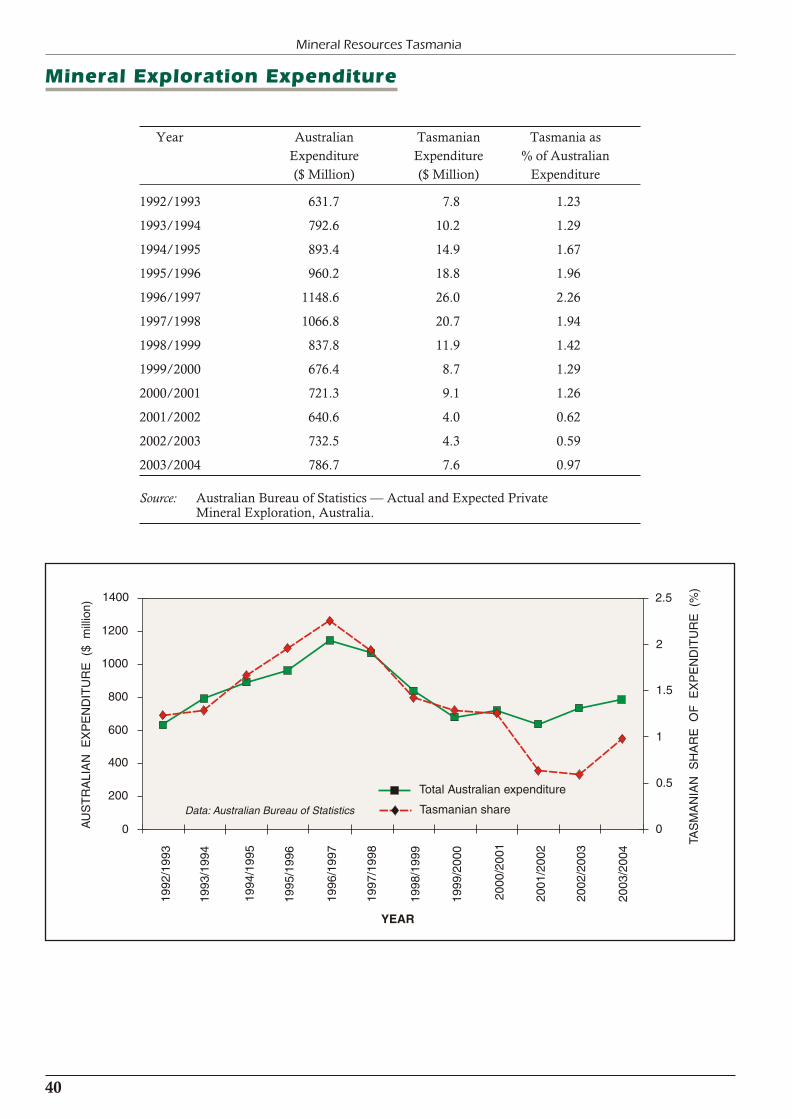
Mineral Exploration Expenditure
Year Australian Tasmanian Tasmania as
Expenditure Expenditure % of Australian
($ Million) ($ Million) Expenditure
1992/1993 631.7 7.8 1.23
1993/1994 792.6 10.2 1.29
1994/1995 893.4 14.9 1.67
1995/1996 960.2 18.8 1.96
1996/1997 1148.6 26.0 2.26
1997/1998 1066.8 20.7 1.94
1998/1999 837.8 11.9 1.42
1999/2000 676.4 8.7 1.29
2000/2001 721.3 9.1 1.26
2001/2002 640.6 4.0 0.62
2002/2003 732.5 4.3 0.59
2003/2004 786.7 7.6 0.97
Source: Australian Bureau of Statistics — Actual and Expected PrivateMineral Exploration, Australia.
40
Mineral Resources Tasmania
YEAR
Total Australian expenditure
Tasmanian shareData: Australian Bureau of Statistics
TAS
MA
NIA
N S
HA
RE
OF
EX
PE
ND
ITU
RE
(%
)
2.5
2
1.5
1
0.5
0
1998
/199
9
1999
/200
0
2000
/200
1
2001
/200
2
2002
/200
3
1997
/199
8
1996
/199
7
1995
/199
6
1994
/199
5
1993
/199
4
1992
/199
3
AU
ST
RA
LIA
N E
XP
EN
DIT
UR
E (
$ m
illio
n)
1400
1200
1000
800
600
400
200
0
2003
/200
4

41
2003/2004 Annual Review
Review of Mineral Sector Operations
— Metallic Minerals
BASE METALS
Zinifex Rosebery mine
Zinifex Limited is one of the world’s largest integrated zincand lead companies. The new company has been formed to own and operate two mines, Rosebery and Century mine(in Queensland), and four smelters that were owned byPasminco Limited.
Total ore production for the year was 785 000 tonnesgrading 13.6% Zn. Production from the lower levelstotalled 623 419 tonnes at 14.4% Zn and came from K andP Lens’. Production from the upper levels totalled162 193 tonnes at 10.6% Zn, coming from remnant miningfrom the No. 1 Shaft Pillar as well as cut and fill stopingfrom 17B South and the Access I.
Mine development
Total development advance totalled 4202 metres. Capitaldevelopment advance was 1257 metres which was mostlyrequired to continue extending the K North and P declinesand the P incline, in order to access future ore zones. Theoperating development was predominantly in the two main lower working panels, K Lens (42–46K), and P Lens(40–44P), and in Upper P Lens. Of the advance1376 metres were in waste and 1567 metres were in ore.
Mill production
Ore treated totalled 739 417 tonnes grading 4.48% Pb,13.71% Zn, 0.44% Cu, 117 g/t Ag and 2.04 g/t Au. Thiswas an 8.2% decrease in tonnage treated through theconcentrator compared with the previous year. The majorreasons for this reduction were a 7.7% decrease in tonnagefrom mine production and reduced throughput to maintainmetal recovery.
1 Gold production as doré totalled 346 kg containing 31% silver and 67% gold. This was down by 22.1% on theprevious year owing to a 33.1% reduction in gold todoré recovery. Gold head grades were up 20% on last
year but the gold to doré recovery was down due a
change in mineral association.
1 Copper metallurgy improved from the previous year. A
29.4% increase in head grade and a 24.2% improvement
in recovery resulted in a 44.1% increase in concentrate
production to 10 395 tonnes grading 7.15% Pb,
20.46% Cu, 2868 g/t Ag and 70 g/t Au.
1 Lead concentrate output increased by 2.3% on the
previous year to 43 141 tonnes at 64.01% Pb and
873 g/t Ag, mainly due to a 14.9% increase in head
grade on last year.
1 The high purity zinc concentrate of the previous year
was sustained. Zinc concentrate output increased by
9.4% to 155 208 tonnes at 57.17% Zn, mainly due to a
20.3% increase in head grade.
Reserves (as at March 2004)
Overall resources decreased by 1.705 million tonnescompared to the previous year due to deletions frommining and revision to resources. Reserves increased by478 000 tonnes compared with March 2003. This wascaused by conversion of inferred resources to reserves,mainly in K lens, and revisions, mainly in P lens. Theincreases were offset by depletions from mining andrevisions in the Upper Levels remnant mining reserves.
Identified ore reserves and resources at March 2004comprised:
Reserves Tonnes Pb Zn Cu Ag Au Fe (000s) (%) (%) (%) (g/t) (g/t) (%)
Proved 2,450 4.3 15.5 0.45 149 2.2 9.0
Probable 317 3.9 13.4 0.32 131 2.2 9.2
Total 2,767 4.2 15.3 0.43 147 2.2 9.0
Drilling
A total of 25 895 metres of diamond drilling wascompleted. The main areas of investigation were K LensNorth and at depth below P Lens.
Identified Mineral Resources, March 2004
tonnes Pb Zn Cu Ag Au Fe(000s) (%) (%) (%) (g/t) (g/t) (%)
Rosebery Measured 2 741 5.2 19.6 0.58 202 3.0 11.3
Indicated 868 4.5 16.0 0.62 160 3.4 14.2
Inferred 3 032 4.5 15.4 0.46 191 2.2 9.8
Inaccessible 1 953 3.4 11.4 0.71 110 1.9 15.1
Total Meas+Ind+Inf 6 640 4.8 17.2 0.53 191 2.7 11.0
South Hercules Total 560 1.9 3.7 0.11 157 3.0 4.4
GLOBAL Meas + Ind + Inf 7 200 4.6 16.2 0.50 188 2.7 10.5
42
Mineral Resources Tasmania
Capital expenditure
Capital expenditure during the year totalled $10.7 million.The major projects included:
1 underground development and construction of anunderground pump station;
1 purchase of an underground truck and undergroundlight vehicles;
1 raising the wall of the tailings dam; and
1 concentrate handling upgrade
Employment
A total of 194 people were employed in the mine. Fourlost-time accidents were sustained.
The mining department achieved a record 506 days LTIfree. OH&S management programs are focussed uponbehavioural systems and catastrophic risk management.The site is moving towards AS4801 certification. A total of73 Process Improvement Opportunity strategies weresubmitted by employees during the year.
Environmental management
ISO14001 Environmental Management Systemcertification has been maintained, and over 200 siteemployees and contractors have undergone environmentaltraining. Improvements to environmental risk management and compliance management have been completed thatwill facilitate ongoing improved performance of theoperations.
An estimated 605 000 tonnes of mill tailings were pumpedto storage in the Bobadil tailings dam during 2003/2004.The dam wall was raised during the summer and includedmodifications to the polishing pond that will enable bettermanagement of discharge water quality.
The Hercules EIP was concluded and formal closure of thesite was initiated. A closure plan developed in consultationwith the community and other stakeholders will beprepared by October 2004.
Biological monitoring of macro invertebrates has beeninitiated in the Ring River and Stitt River. Results from theStitt River are encouraging and indicate the existence of ahealthy population of fish. The results for the Ring Riveridentify significant impacts as a consequence of historicalmining practices around the Hercules site.
A full three-year environmental management plan reviewwas completed. It is hoped that the EMP review will formthe basis for modifications to the permit to fully reflect thenature of the operations. A review of rehabilitationrequirements and closure obligations was completed. As aconsequence more detailed and comprehensive closureplans and rehabilitation strategies will be developedco-operatively with the Department of Primary Industries,Water and Environment during the coming year.
Community relations
Zinifex Rosebery Mine continues to support the localcommunities through grants and sponsorship of sportingteams and community groups. Education and trainingsupport amongst the community has been maintained andincluded:
1 Eleven apprentices sponsored through Northern GroupTraining/William Adams and Caterpillar Elphinstone.
1 Education assistance to 15 eligible dependants ofemployees (12 at university and three attending college).
During late 2003 a MOU was signed with the RoseberyDistrict High School for the relocation and establishment of the mine nursery to the school as an applied learningproject. Community consultation and liaison with thecommunity and key stakeholders has been completed aspart of the Hercules mine closure process.
Intec Hellyer Metals Ltd
Intec Limited purchased the Hellyer tails resource, millinfrastructure and exploration licenses/leases from theReceiver for Western Metals Limited in January 2004.Intec Limited is a proprietary hydrometallurgicaltechnology development company. Ammtec Limitedpurchased the metallurgical research facility at River Road, Burnie. Ammtec is a Perth-based commercial metallurgicaltestwork company.
At year-end Intec had one full-time employee in Tasmania, with three sub-contracted employees undertaking Hellyercare and maintenance activities. The Burnie researchlaboratory employed six people full time and one part time.
The Hellyer concentrator and services infrastructureremained on care and maintenance pending discussionswith local mining companies on toll treating ore throughHellyer. Other options for the mill equipment were alsobeing considered.
The Hellyer tailings resource contained in a water-coveredstorage dam comprise 10.88 million tonnes at 0.16% Cu,3.0% Pb, 2.8% Zn, 88 g/t Ag and 2.6 g/t Au.
Hellyer Metals Project
The project aim is to process Hellyer tails and possiblesmelter waste feedstocks containing zinc and preciousmetals to produce zinc metal, copper oxychloride, lead and silver contained in a cement product, and gold bullion atthe Hellyer mine site. The Intec Polymetallic Leach process includes chloride leaching of tails and smelter waste, zincliquor iron removal with limestone, zinc dust cementationof lead and silver, zinc liquor purification andelectrowinning.
Progress to June 2004 included:
1 Pilot plant testing of the Intec Polymetallic Leachprocess at Brookvale in Sydney. The testworkcampaigns confirmed high extractions of zinc, lead,silver and copper. Gold extractions were lower due tothe refractory nature of the gold.
1 A pre-feasibility study was undertaken by HGEngineering Company in Canada. The outcome of thestudy was positive, with the next phase to construct ademonstration plant at the Burnie Research Labs in late2004.
1 Discussions were held with several parties who ownzinc-rich residues that may be amenable to reprocessingat the proposed Intec plant. These discussions areongoing.
43
2003/2004 Annual Review
Intec Limited will be undergoing a capital raising programin September/October 2004 to enable it to undertakefurther development of the Hellyer process and on otherproprietary Intec process development opportunities.
Intec Hellyer Metals Ltd also undertook a study into basemetal and gold exploration opportunities on the Hellyer,Que River and Mt Charter leases. The aim was toencourage third party exploration of select targets.Discussions with potential explorers are continuing.
Zeehan Zinc — Comstock
Mine development
Earthmoving operations having being directed towardscompleting the rehabilitation of the Central Waste RockDump, and the preparation of road access to the base of the Swansea Tramway Dump. This required the movement ofapproximately 30 000 tonnes of clay and waste.
Employment
Up to a total of forty people were employed during theyear.
Reserves
Zeehan Zinc has continued an ongoing review of resourcesalong the Balstrup Fault. Renison Goldfields ConsolidatedExploration Pty Ltd had calculated resources of 6 Mt at5.5% Zn, 3.3% Pb and 40 g/t Ag, while Western MetalsLimited had calculated resources of 5.1 Mt at 4% Zn and3.3% Pb.
COPPER
Copper Mines of Tasmania
Pty Ltd — Mt Lyell mine
The company reports that it remains committed to thecontinued operation of the Mt Lyell site. Investment invarious projects has resulted in the cost per tonne of copperproduced being maintained. Development of the decline tothe next production level, as well as level accessdevelopment, was completed. The company continues toseek ways to improve production while improving the coststructure.
Production
Production from the Prince Lyell mine was 2 514 484tonnes at 1.22% copper and 0.3 g/t gold. Production levelswere lower than the previous year, although the mineproduced at record tonnes for a three-month period, untilproduction was rescheduled to meet processingperformance. Waste mined totalled 53 054 tonnes.
Development
A total of 305 metres of decline development werecompleted as well as 318 metres of access development inwaste. Total development (ore and waste) for the year was3039 metres. Planned development for 2004/2005 is
2940 metres, including development of the decline to access the next level at 1465 mRL.
Reserves
Total Mineral Resources at 30 June 2004, at 1% Cu cut-off, were estimated at 36.09 million tonnes at 1.26% copper and 0.34 grams of gold per tonne. Measured and IndicatedMineral Resources total 11.06 million tonnes at 1.33%copper and 0.36 grams per tonne of gold.
The June 2004 Mineral Resource has not been converted to an ore reserve. The 2003 total ore reserve, depleted forproduction (2.5 Mt), was 4.50 Mt @ 1.29% Cu, 0.30 g/tAu.
Processing
A total of 2 465 398 tonnes of ore was processed producing95 742 dmt of copper concentrate grading 28.70% Cu,4.9 g/t gold containing 27 478 tonnes of copper and15,432 ounces of gold. Processing plant performance hasdeclined from the previous year, as throughput rates havebeen affected by the quality of material being processed.Main problems were in the tertiary and quaternary circuitswhere difficulties occurred with sticky, fine material,resulting in blockages. Increased quaternary screen andcrushing capacity was installed to overcome the bottleneck. Further improvements to the fixed plant are being assessedand considered to improve both consistency ofperformance and throughput rates.
Capital expenditure and projects
Total capital expenditure for the year was $3.744 million.Major items included extension of the main decline below1490 mRL, as well as level access, a pump station, and areplacement ventilation system in the lower part of themine. On the surface, capital was spent on a 140 mmSymons crusher and associated quaternary circuit upgrade.
Employment
The operation employed 250 people. Numbers varied fromthe previous year due to changes in shift roster patterns and variations to production and development schedules in themine. CMT directly employed 94 people, with 12 in themine, 39 in metallurgy, 29 in maintenance and 14 inadministration. Barminco, the underground miningcontractor, employed 150 people on site in the areas ofmine production, crushing, mobile and fixed plantmaintenance and administration. It is planned to continuewith the use of an underground mining contractor toundertake all production, development and services workin the mine. Additional contractors are used as required for shutdown and project work.
Rehabilitation and pollution control initiatives
Copper Mines of Tasmania has active programs ofenvironmental improvement and pollution control at theMount Lyell mine site and Princess Creek tailings storagefacility. Significant environmental projects during the yearincluded:
1 Continued rehabilitation of the intermediate stage of the waste rock dump. This includes forming of a watershedding landform and compacted clay cover.Revegetation is in progress.

44
Mineral Resources Tasmania
1 Continued reduction in size of the operations footprint.This includes ongoing clean up of the historic site andplanning for progressive removal of redundant, lowheritage value infrastructure and establishment of native vegetation.
1 Sustained improvement of water quality released fromthe tailings dam, with no breaches of water quality since August 2002. Includes active management of decantpond water levels and strategic placement of tailings instorage. Planning for a raise of the tailings dam wallduring the summer of 2004/2005 is in progress.
1 Active programs of environmental awareness raising,including a site environmental newsletter, increasedenvironmental profile, advancement of the site EMSand improved documentation.
1 Continual improvement in stormwater drainagemanagement on the mine and mill site, includingclosure of old drains and construction of additionalsediment traps.
CMT met its obligations to neutralise acid drainagegenerated by its mining operation, using co-treatment withalkaline tailings, and is working closely with thegovernment to reduce the acid drainage load from historicmining operations. Government-funded drainageimprovements have successfully segregated the mostintensely polluted water from clean water, in preparationfor potential treatment of the acid drainage.
Gold
Beaconsfield Mine
Joint Venture
The joint venture reports that production for 2003/2004was a record for tonnes of ore mined and milled andounces of gold produced. The one millionth tonne of orewas milled on 22 June 2004. Coincidentally, this milestonewas achieved on the 40th anniversary of the day on whichthe first modern diamond-drill hole was collared.
Production
A total of 4670 kg of gold and 534 kg of silver wasproduced from 234 440 tonnes of ore milled. Waste minedduring the year totalled 157 114 tonnes, of which52 156 tonnes was utilised as backfill underground with the remainder hoisted to the surface. The majority of the wasterock hoisted to the surface was utilised for the final stage ofconstruction of the tailings dam.
Major projects
Construction of the tailings dam was completed, withsufficient capacity until mid 2007. A major undergrounddiamond drilling program commenced with the aim ofextending the resource and generating an ore reservesufficient for five years production from mid 2005. Almost9000 metres of drilling was completed in the six months toJune 2004 with an additional 17 000 metres consideredlikely over the course of the next year.
Reserves
The ore reserves reported at 30 June 2004 comprised:
Measured Resource 149 000 tonnes at 29.8 g/t Au
(143,000 ounces contained gold)
Indicated Resource 400 000 tonnes at 22.2 g/t Au
(285,000 ounces contained gold)
Inferred Resource 586 000 tonnes at 19.0 g/t Au
(358,000 ounces contained gold)
Total Resource 1 135 000 tonnes at 21.5 g/t Au
(786,000 ounces contained gold)
Proven Reserve 226 000 tonnes at 17.9 g/t Au
(130,000 ounces contained gold)
Probable Reserve 510 000 tonnes at 15.3 g/t Au
(251,000 ounces contained gold)
Total Reserve 736 000 tonnes at 16.1 g/t Au
(381,000 ounces contained gold)
Capital expenditure
Capital expenditure for the year totalled $7,954,753. Majoritems of capital included:
1 the installation of a new regrind ball mill at theprocessing plant and rockbreaker over the grizzly on the underground hoisting system;
1 commencement of a major underground resourcediamond-drilling program;
1 completion of the final lift on the tailings dam;
1 construction of a second stock tank on the bacterialoxidation circuit;
1 installation of forward-facing cabs on two of the threeunderground trucks;
1 purchase of a new telehandler; and
1 a geotechnical site investigation at the site of a proposed new tailings dam.
Employment
At year end, the joint venture employed 134 people ofwhom eight were in technical services, 79 in mining, 36 inprocessing, eight in administration and two in occupational health and safety. Contractors were engaged for somemining and maintenance services, security, surface orehaulage and the assay laboratory.
Environmental management
With the completion of the final lift of the tailings dam to90 mRL, the outside batter slopes were covered with a layer of soil which had been stockpiled for the purpose, and thenhydro-mulched. At this stage a good strike of stabilising rye grass has occurred and it is anticipated that native seed willstart to grow in the coming spring.
A statutory revision of the project environmentalmanagement plan was completed early in 2004. In addition to the EMP review, the joint venture has undertakenseveral environmental studies including a baselinebiological study of Brandy Creek and Middle Arm Bay,and water quality monitoring of Middle Arm Bay. A mineclosure plan was also completed.
45
2003/2004 Annual Review
Placer Dome Asia Pacific
— Henty Gold mine
Production from the West Coast mine totalled 4389 kg ofgold and 1008 kg of silver, with 289 000 tonnes of ore and63 000 tonnes of waste being mined. Mining of Zone 15and the Intermediate Zone was completed. Development of the main Darwin South infrastructure was completed andmining was started in the orebody.
Reserves
Resources and reserves as at December 2003 comprised:
Measured + indicated resource 994 000 tonnes at 11.6 g/t Au
(369,000 ounces contained gold)
Inferred resource 300 000 tonnes at 8.7 g/t Au
(84,500 ounces contained gold)
Total resource 1 294 000 tonnes at 10.9 g/t Au
(454,000 ounces contained gold)
Proved + probable reserves 973 000 tonnes at 10.6 g/t Au
(333,000 ounces contained gold)
Rehabilitation, environmental andpollution control initiatives
The operation’s first stand-alone environmental policycame into effect during the year. This policy was developed through a consultative process with all site personnel, andstates the company’s commitment to preservation of theenvironment.
The site achieved a significant reduction in greenhouse gasemissions, due largely to reductions in diesel consumptionand explosives usage. The diesel consumption reductionresulted from a number of factors:
1 Winding down of mining in the upper reaches of themine, resulting in less travelling for equipment movingbetween operating locations.
1 Cessation of direct trucking of ore from underground tosurface.
The reduction in explosives usage was achieved by achange in mining methods. This was made possible bychanges in orebody characteristics and ground conditions.
The annual biological monitoring survey of the HentyRiver upstream and downstream of operations continued to confirm that the mine is having no impact on stream fauna. This was the eleventh year that the mine has carried outthis survey, which is a good indicator of the mine’sperformance with respect to managing pollutant levels indischarge water.
A review and update of Henty’s EnvironmentalManagement Plan was submitted to the Department ofPrimary Industries, Water and Environment. This reviewoutlines changes to the operation in the past three years,and planned modifications for the coming three years.
Capital expenditure
Capital expenditure totalled $12 million during the year.Major items included a paste fill plant, undergroundequipment, two trucks, a loader and a drill rig.
Employment
The operation employed 173 people, including 64contractors.
Safety program
The company has developed an implementation plan tocontinually improve safety performance at Henty. Featuresinclude a management information system, teaminvolvement, training programs and supervision.
Iron ore
Australian Bulk Minerals
(Savage River Mines)
Mine life has been extended to May 2009 through thedevelopment of Centre Pit South. A pre-feasibility study ofthe potential to continue ore extraction from North Deposit using underground mining methods, after the exhaustion of open pit reserves, was completed. The study indicated thatunderground mining using a block caving mining methodwas technically feasible. Although the project is marginal,the operation may prove attractive for a long-term supplyof iron ore pellets, particularly in current marketconditions. Interest is being sought to advance the project.
Employment
A total of 444 people, including contractors, are employedin the operation, with 189 in the mine, 98 in theconcentrator and 157 in the port, pellet plant andadministration.
Production
Production from the Savage River mine totalled 1.3 million cubic metres of iron ore and 7.8 million cubic metres ofwaste, a total of 9.1 million cubic metres mined. Of this5.09 million tonnes of ore were milled. Pellet productiontotalled 2.2 million tonnes, with 2.1 million tonnes ofpellets, 9300 tonnes of concentrate and 71 000 tonnes ofchips being sold.
Reserves
Resources at the end of June 2004 comprised:
North pit 88.9 million tonnes @ 51.7% DTR
South deposit 29.2 million tonnes @ 41.7% DTR
Centre pit south 59.7 million tonnes @ 48.9% DTR
Centre pit north 70.3 million tonnes @ 51.0% DTR
Total 248.1 million tonnes @ 49.6% DTR
Diluted recoverable reserves comprised:
North Pit 15 million tonnes @ 51.1% DTR
Centre pit south 9.9 million tonnes @ 47.1% DTR
Stockpiles 0.507 million tonnes @ 38.8% DTR
Capital expenditure
A total of $3.9 million was spent on capital expenditureduring the year. Major programs included tailings pipeline,diamond drilling, ball mill replacement, geotechnicalequipment, south centre pit dewatering, control systems,furnaces and electrical upgrades at Port Latta.
46
Mineral Resources Tasmania
Environmental and rehabilitation activities
Weed management was carried out at the former SavageRiver town site. Revegetation of land to the west of the stye at Port Latta continued, with weed management andreplanting. The company continued to fund the Coastcareprogram from Rocky Cape to Port Stanley. Dust deposition was measured at Cowrie Point and Crayfish Creek by highvolume air sampling with selective PM10 inlets. Theannual averages were 25.92 and 22.82 µg/m3 respectively.
In situ classification and separation of waste rock from thepits has continued. Waste from south deposit was placedalong the eastern boundary of B dump in clay-lined cellswith an alkaline rock cover. Alkaline rocks were alsoplaced to increase the length of the Broderick Creek wastedump flow through. These measures helped to achievesatisfactory copper levels in Savage River.
Nickel
Allegiance Mining NL
This company has identified an important nickel resourceat Avebury, six kilometres west of Zeehan, after severalyears of successful exploration. Following the issue of amining lease, assessment by the Department of PrimaryIndustries, Water and Environment, and developmentapproval from the West Coast Council, access andinfrastructure work commenced in January 2004. Workundertaken includes:
1 access and infrastructure is under construction;
1 development of the 1200 metre Viking Decline toprovide access to the Viking and North Aveburydeposits commenced;
1 10 000 metres of core drilling, metallurgical test work,and mine design studies are planned.
Anticipated cost for this investigation stage is $9.5 millionand is scheduled for completion in February 2005.Technical information will be used to prepare a definitivefeasibility study on the commercial development ofAvebury. With the completion of the study Allegiance willhave spent $16 million on the Avebury project.
The total indicated and inferred resource of the deposit is4.06 million tonnes at 1.5% Ni, representing 61 500 tonnesof nickel.
Tin
Bluestone Mines Tasmania
Pty Ltd
This company acquired the Renison Bell mine following its closure and flooding. Dewatering and rehabilitation of theoperation commenced in April, providing employment fortwelve people and additional contractors.
Reserves
The total measured, indicated and inferred resource is4.1 million tonnes at 1.75% Sn. Proved and probablereserves are 1.1 million tonnes at 1.60% Sn. Identifiedtailings resource is 17.9 million tonnes at 0.42% Sn.
Capital works
Expenditure on mine rehabilitation totalled $3.6 million.

47
2003/2004 Annual Review
Industrial Minerals
Limestone and dolomite
Beams Bros Pty Ltd
Operations continue to employ 22 people. Production forthe year comprised:
Metallurgical grade limestone 15 000 tonnes
Metallurgical grade dolomite 45 000 tonnes
Agricultural grade limestone and dolomite 77 000 tonnes
Dolomite 12 000 tonnes
A total of 22 000 cubic metres of waste stripping wascarried out at Flowery Gully and Cressy. Accessdevelopment was carried out within both quarries.Revegetation was carried out at the Cressy waste dump and at Flowery Gully.
Circular Head Dolomite
and Trading Co. Pty Ltd
This company produced 19 000 tonnes of dolomitescreenings, 30 000 tonnes of powder and 8000 cubic metresof ready-mixed concrete. Thirteen people were employed.Reserves at the Smithton leases are extensive.
Capital improvements include the provision of a portablejaw crusher and generator, a truck, and improving capacityby installing a larger screen. Exporting material formagnesium production is being investigated.
Unimin Australia Limited
This company operates a limestone quarry and calciner atMole Creek. Twenty-nine staff were employed throughoutthe financial year, comprising 21 in the quarry and limeplant operation, one in maintenance, two in administration and five in management and sales.
Production
Total limestone production was 147 340 tonnes, whichincluded 12 826 tonnes of crushed rock and 1282 tonnes of
screened rock. The remaining production was for
agricultural use and calciner feed.
Reserves and resources
Feed for the kiln was predominantly high-quality and
medium-quality limestone with some additional low
quality as the use of the resource is optimised and product
quality improved.
Feasibility work on a new agricultural lime plant was
completed. Whole-of-life stripping ratio and reserves of
high, medium and low quality limestone have been
reviewed and upgraded and the life of the resource
significantly extended.
Major projects
Work is continuing on a number of projects connected with
ensuring a long-term future for the operation. New dust
collectors were installed to the quicklime and hydrate
systems at a cost of around $200,000. Approval was
granted and design work commenced on the replacement
of the kiln top with a new and improved design at a cost of
around $400,000. Numerous small OH&S and
environmental projects continued to the value of $100,000.
Rehabilitation and environmental control
Normal procedures in line with Department of Primary
Industries, Water and Environment licence conditions
continued.
Stack emissions tests were carried out to verify compliance
at normal operating levels. Work continues on addressing
compliance at elevated kiln production levels, with design
work well in hand on new dust removal equipment.
Boundary noise was measured and a fugitive dust
management plan was prepared.
The total area disturbed by operations remains at
approximately 47 hectares. No land has been rehabilitated
to date but a site rehabilitation and closure plan has been
prepared.

Construction Materials
Boral Construction
Materials Group Ltd
The company continues to produce from twelve quarries
around Tasmania. Production exceeded 500 000 tonnes,
45% of which was road making material. Operations
employed 23 people and six subcontractors. A total of
23 000 tonnes of overburden was removed from quarries at
Bridgewater, Flowery Gully, The Nook and Remount
Road, Launceston.
Rehabilitation continues at the former limestone quarry at
Mt Nassau (Granton), and at Launceston. Rehabilitation
has commenced at McGrath’s quarry near Breadalbane,
and at South Arm. Upgrading of screens and walkways
was carried out at the Launceston Quarry.
Caroline Quarries
This company reported production of 14 300 tonnes of
silica sand from their Railton quarry, providing
employment for one permanent and two part-time
employees.
Duggans Pty Ltd
The company reports an increased level of production for
the year. Production of road making materials, concrete
products, construction materials and ready-mixed concrete
exceeded 100 000 tonnes. Nine people were employed.
Capital expenditure included a primary crusher, a loader
and excavator. Investigations were made into the potential
use of crushed sandstone for sand products.
Environmental works include maintenance of sediment
dams, rehabilitation and dust control. All waste material
from the concrete batch plant is recycled. Waste from
precast concrete products is utilised in road base to meet
Australian Standard HB 155-2002.
Gunns Limited —
Northeast quarry operations
This company operates 31 quarries in northeast Tasmania
for road making operations, mainly in connection with
forestry activities. Production for the year was 56 000 cubic
metres of road gravel. Up to thirty people were employed at
the height of the construction season. The operations are
intermittent and nearly all operations use subcontractors.
Reserves are plentiful for the foreseeable future. Four new
quarries were established during the year. A source of
aggregates on the East Coast continues to be elusive. A
total of $20,000 was spent on progressive rehabilitation and
drainage works.
Hanson Construction
Materials
The 2004 year was an exciting one for the company, withthe name change from Pioneer Concrete from 1 July andthe acquisition of Besser Tasmania, now known as HansonBuilding Products. Hanson also purchased the Calderquarry from Besser on 1 January.
Thirteen employees and contractors were employed inadministration and production. Production for the yearexceeded 260 000 tonnes of crushed rock at Hobart, and30 000 tonnes of sand from Calder since January 2004.
Rehabilitation continues in all areas, with a focus oneliminating pampas grass. Overburden stripping of RL170–165 has been stockpiled for future rehabilitation work.A trial of foam water mixture for haul road dustsuppression is being carried out.
A sales loader was purchased during the year. Adevelopment application has been submitted to theClarence City Council to extend quarry reserves to RL305.The result of this application is awaiting the outcome of anew planning scheme.
Industrial Sands and
Silica Pty Ltd
This company reported production of almost 11 000 tonnes of sand and gravel and that two people were employed.
Island Resources
Eight people, including contractors, are employed in theoperation in northeast Tasmania. A total of 94 000 tonneswere produced, with major products being concrete andfoundry sand and road gravel. The leases contain extensivesand and gravel reserves. Major projects undertaken duringthe year included the completion of a gas-fired drying plantat an estimated cost of $400,000.
Norske Skog
This company reports producing 86 000 tonnes of crushedrock for road construction and maintenance, with some 32kilometres of new roads being constructed. Fourteenpeople, including contractors, were employed in thequarrying operations. Principal pits worked wereBannisters, Maynes, Mt Lloyd, Puzzle and West Uxbridge. Material is extracted using a combination of drilling,blasting and crushing, or by direct excavation wherepossible. The company has fourteen quarries in State Forest and eight on private property. Life of the current pits is10 to 15 years.
The company has an annual budget of $30,000 forrehabilitation of quarries. Work includes regrading,planting vegetation and fertilising at sites where production
48
Mineral Resources Tasmania

49
2003/2004 Annual Review
has ceased. Junee, Shoobridge and Rayners quarries are inan advanced stage of rehabilitation. Continuousmaintenance includes clearing silt traps, and the placementof stockpiles of overburden and topsoil for rehabilitationwork.
RNB Trading Pty Ltd
This company reports that 97 000 tonnes of building sandwere produced at South Arm. Four people are directlyemployed. Representations were made for the development of the Clarence Planning Scheme with respect of extractiveindustries which supply the Hobart region.
Stornoway Quarries Pty Ltd
This company reported the production of 189 000 tonnes of structural and pavement materials, mainly from the
Raeburn quarry. Reserves provide for approximately tenyears life. Capital expenditure was $250,000. Operationsare controlled through an integrated environmentalmanagement system incorporating ISO 9002, ISO 14001and AS4801.
Treloar Transport Co.
Approximately 45 000 tonnes of crushed rock wereproduced, with base course for road construction being thechief product. Quarrying directly employed five people.Rehabilitation utilising limestone was carried out tomitigate the effects of pyritic leaching. Developmentsinclude planning for a crushing plant and G6 compliance(geological survey for road specification quality control).
Fuel Minerals
Cornwall Coal Company NL
A total of 61 people were employed in mining, processingand administration, with a further 17 contractors employed in open-cut operations and raw coal transport.
Duncan Colliery
Production continued throughout the year using acombination of pillar development and pillar extraction.All underground production from the Fingal Valley wasconcentrated at the Duncan Colliery.
Cullenswood open cut
The bulk sample operation continued throughout the year,with product proving satisfactory for customerrequirements. A development application is in preparationto enable mining within the rest of the lease.
Kimbolton Coal
All major environmental works were completed prior tocoal extraction commencing. Three strips were removedduring the year with the majority being sent to a localcustomer. The characteristics exhibited by the product coalcreated difficulties in handling and use. Mining wassuspended while the difficulties were investigated andactivities were relocated to Cullenswood.
Production
Production for 2003/2004 totalled 504 674 tonnes. Thiscoal was sourced from:
Duncan 436 736 tonnes
Cullenswood 15 192 tonnes
Kimbolton 52 746 tonnes
An additional 1250 tonnes of coal was purchased.
Washery throughput of raw coal totalled 475 857 tonnes toproduce 335 538 tonnes of saleable coal at a washery yieldof 66.76%. Coal sales totalled 393 370 tonnes.
Approximately 140 319 tonnes of reject materials weredeposited at the Duncan reject dump.
Reserves
Coal resources exceed twenty years life.
Capital expenditure
A total of $2.9 million was spent on plant and equipmentthroughout the year, the major expenditure being a miniwall mining system for the Duncan Colliery. This will bebrought into production in 2004/2005.
Laboratory facilities were upgraded with the addition of aspecialised oven.
Fuel distribution was upgraded with the purchase of dieselstorage.
Rehabilitation
Blackwood Colliery was rehabilitated and seed was applied using local species. Huntsman No. 2 open cut wasrevegetated using local species. An ongoing monitoringprogram is in place to determine germination and growthrate.
Mineral Processing Operations
Cement Australia Holdings
Pty Ltd
This company reported a continued high demand forcement products for the building and constructionindustries in Tasmania and in mainland States. A total of163 people are employed on site, including 155 in mine and plant operations.
Production
Production at the Railton cement plant totalled 1.115million tonnes of clinker which is a record for theoperation. A total of 1.205 million tonnes of cement wasproduced from the clinker, of which 1.086 million tonneswas shipped to markets in Victoria and NSW. Sales of theremaining production comprised 78 900 tonnes sold in bulk in Tasmania, and 43 000 tonnes of bagged cement.
Capital expenditure
A total of $3.7 million capital was spent during the year.This included completing the upgrade of the plant’s control system and electrical infrastructure.
Development
An extensive exploration program commenced in February 2004 to further define the deposit. The program is expectedto finish in August 2004 and will include approximately3000 m of diamond core drilling, 2500 m of RC drillingand over 1000 m of air core. The data collected will be used to update the ore block model with a view to furtheroptimization of the pit design and to investigateopportunities within the existing leases.
A total of 298 000 cubic metres of clay was taken from thenorthwest cutback of the New Mine during the lastfinancial year. This area of the pit is now providing goodquality limestone for cement production. A total of 2331cubic metres of topsoil was stripped and stockpiled forrehabilitation in the future.
Environmental management
A Site Water Management Plan has been adopted for themanagement of groundwater and surface water frommining and cement manufacturing operations. The planincludes concrete lining of hundreds of metres of drainsand the transformation of the disused open cut into a lake,which will act as a settlement pond. Both of these activitiesare designed to minimise sediment discharge to localwaterways to acceptable levels and to protect vulnerablespecies downstream.
The environmental management plan was updated toreflect current practices and plans for rehabilitation andcomplies with higher internal Cement Australia policiesthat were recently introduced.
Regular environmental activities, such as the measurementof groundwater levels through piezometer dipping andwater quality sampling and testing, were ongoing. Aneducation program for employees was conducted that
included fact sheets and information sessions on fourvulnerable species that are either on the property ordownstream of the operations.
Comalco
Comalco operates an electro metallurgical aluminiumrefinery at Bell Bay. A total of 629 people were employedincluding contractors. Production of aluminium was166 000 tonnes. Capital expenditure was $31 million.Major projects included:
1 Upgrade in smelter capacity achieved through amperage creep (from 109 kA to 114 kA).
1 Extension of natural gas to the casting shop, greencarbon and rodding room. The carbon baking furnacewas converted on arrival of natural gas to Tasmania.
1 Upgrade of information technology infrastructure.
1 Replacement of robot ingot stacker for the casting shop.
Impact Fertilisers
Production at the Hobart facility exceeded 180 000 tonnesof single superphosphate. A total of 105 people wereemployed together with an additional 20 contractors.
Development projects
The following capital projects were under way orcompleted during the year:
1 Air hygiene system in plant.
1 Effluent recycling pond and catchment system.
1 New scrubber plant for plant emissions.
1 Improved hoppers for dust control at wharf forunloading phosphate rocks.
1 Increased storage areas in Hobart and regional areas.
1 Out loading SSP dust control measures.
Tasmanian Electro
Metallurgical Co Pty Ltd
(TEMCO)
This company operates an electro-metallurgical smeltermaking ferro-alloys at Bell Bay. The company employs 275 people in production and administration, includingcontractors.
Production for the year comprised 133 000 tonnes offerro-manganese, 116 000 tonnes of silicon-manganese and214 000 tonnes of sinter. Sales totalled 134 000 tonnes offerro-manganese, 123 000 tonnes of silicon-manganese and377 000 tonnes of sinter.
Capital expenditure and major projects
A total of $7.6 million was spent on cost reduction, processimprovement and capital works. Major projects included:
50
Mineral Resources Tasmania

51
2003/2004 Annual Review
1 Tapping floor and slag fume collection upgrade for
No. 5 Furnace ($1.0 million).
1 Additional day bins for No. 3 furnace ($700,000).
1 Replacement of No. 5 furnace transformers ($600,000).
1 MIMS upgrade ($400,000).
1 Additional day bins for No. 5 furnace ($200,000).
1 Energy recovery unit Bailey replacement ($200,000).
1 Metal launder fume collection for No. 1 and No. 2
furnaces ($200,000).
Environmental works
The company is signatory to the Australian MineralsIndustry Code for Environmental Management 2001 andmaintains continued certification to ISO 14001.
1 Special projects have reduced the incidence of furnace
trips and reduced fugitive dust emissions. These have
involved engineering controls to the flare stacks and
improved procedures.
1 Investigations of fume dam mud recycling and
installation of a wet scrubber.
1 Land Care of the site has been increased to reduce
fugitive dust emissions and enhance the greening of the
site.
The rare and endangered species project with the RoyalTasmanian Botanical Gardens is continuing to develop.
Zinifex Hobart Smelter
The Risdon zinc smelter, formerly owned by Pasminco,became part of the operations of Zinifex Limited fromApril 2004.
The smelter uses the roast leach electrowin smeltingprocess to produce more than 250 000 tonnes of zinc metalper year, most of which is premium zinc alloy product.Zinifex plans to increase production to 260 000 tonnes peryear beyond 2005, with plans to increase EZDAproduction from 122 000 tonnes to 215 000 tonnes per yearover the next five years.
The smelter also produces more than 420 000 tonnes ofhigh quality sulphuric acid per year and approximately110 000 tonnes per year of paragoethite, which is shippedto Port Pirie for treatment.
Following a plant trial in 2003, the proportion of Centuryzinc concentrate treated was increased from 10 to 35 percent between April and June 2004. Process and plantdesign to convert to even higher levels is continuing withthe objective of achieving 70 per cent Century feed blend in 2006.
Zinifex is expecting to spend around $50 million during2004 and 2005, which includes $20 million formodifications necessary for Hobart to continuously process 70% of its concentrates from Century and $1.9 million toincrease EZDA capacity to 185 000 tonnes in 2005 as thefirst stage of the plan to increase production to 215 000tonnes.

52
Mineral Resources Tasmania

53
2003/2004 Annual Review
ANNUAL REPORT
Rehabilitation of Mining Lands Trust Fund
Mineral Resources Tasmania administers theRehabilitation of Mining Lands Trust Fund to carry outrehabilitation on abandoned mine sites in Tasmania. Thetrust was created by the Mineral Resources Development Act1995, with the State agreeing with the mining and quarrying industries to use a portion of mining royalty raised by theAct for rehabilitating Crown land affected by historicmining disturbance.
A total of $281,000 was spent on this program during theyear, with major programs at Balfour and St Helens.
Balfour
Erosion control and revegetation works were completedover approximately three hectares at Specimen Hill, to theimmediate west of Balfour. Utilising an excavator,earthworks were undertaken to reposition recoveredtopsoil, regrade the area and establish appropriate drainage. A site supervisor was engaged and local labour wasemployed to spread jute matting and native seed.Granulated kelp is being trialled as a soil conditioner andfertiliser.
Expenditure totalled $77,100.
St Helens
Erosion control and revegetation works were undertaken at the old tin mining area along Golden Fleece Creek. Deeperosion gullies were recontoured, while geotextile androck-lined drains were established to help further stabilisethese sites. The earthmoving contractor supplied aninnovative three metre wide ‘comb’ which allowedcross-slope ripping to be undertaken in steep areas. Jutematting was spread and seed and fertiliser applied. A sitesupervisor was engaged and St Helens workers wereemployed and trained to ensure that the project had localownership.
Expenditure totalled $42,700.
Northeast alluvial tin mines
Revegetation works carried over from 2002/2003 werecompleted and maintenance works (weed control andfertilising) were undertaken.
Expenditure totalled $19,200.
Storys Creek program
Revegetation of the jig tailings repository constructed in2003 was completed in July at a cost of $14,600.
Although sampling of Storys Creek and the South EskRiver was carried out throughout the works programs, thesteering committee determined that a monitoring programwas necessary to evaluate the effects of the project. Athree-year program has commenced, with preliminaryresults indicating a reduction in zinc levels in the creek.
Expenditure totalled $7,900.
Rossarden
Although tailings at the Aberfoyle mine were rehabilitatedby the Trust in 1997, revegetation success has been variable across the site due to metal contamination of the onlyavailable cover material. Soil conditioners derived from red mud, a waste product from alumina refining, have gained a reputation for absorbing metals. A trial has commenced togather information on possible application at Rossardenand other sites.
It is anticipated that vegetation should survive if the tailings are treated with Terra BTM, a BauxsolTM-derived soilamendment product designed specifically for the Rossarden application. Two trial areas have been selected, one wherethe tailings cover is contaminated with zinc, and the otherwhere copper-rich material was formerly stored on surface.Virotec International Ltd was the contractor and obtainedits raw material, stored red mud, from ComalcoAluminium Ltd at Bell Bay. Poa seedlings, a native grass,were subsequently planted in June.
Expenditure totalled $11,800.
Shaft, safety and weed control
Construction of a galvanised steel grating, commenced in2003, was completed to cover the Florence Shaft nearZeehan at a cost of $30,100.
Work commenced on a shaft safety program at MountBischoff, which is extensively visited by the public andmineral collectors. A concrete cover for the Central Balfour shaft was also designed. Expenditure totalled $14,500.
A pony trail passes close to the adits and a collapsed stopeat Round Mount near Cethana. The adits were blocked and the collapse protected by a fence. Bridge logs were removed from Machinery Creek and limestone was used toameliorate acid discharge. Expenditure totalled $7,900.
At Oakleigh Creek steel grating was installed over adamaged adit barrier and a formerly unrecognised shaft.Expenditure totalled $13,100.
An amount of $4,400 was spent on a trailer and four-wheelmotorbike maintenance to support Trust programs.
Gorse spraying was again undertaken at the remoteQueensbury mine near Zeehan. The Parks and WildlifeService continue to project manage and conduct this work.Weed removal was carried out at the Zeehan Queen mine,a site of former Trust activity. The Zeehan Landcare Group undertook this particular project. Expenditure totalled$6,900.
Quarry rehabilitation
A steep, disused gravel pit at The Badgers, near Sheffield, is visible from the town. A rehabilitation trial was conductedin 2003 which demonstrated the stability of a bench on thissite. Two additional benches were excavated to providefoundations for vegetation screens on nearby sections.
54
Mineral Resources Tasmania
Areas were ripped and drainage was improved. Steepslopes were protected with jute matting before seed wasapplied. Earthworks were carried out by Treloar Transport, with Conservation Volunteers Australia being engaged tocarry out the seed application.
Expenditure totalled $23,000.
Trust Fund reporting
The steering committee approved a project to publiciseTrust programs. The initial phase is digital capture oftechnical reports describing investigations, plans and results of programs. The reports will be available by documentsearch on the MRT website. Expenditure totalled $6,400.
Mt Bischoff remediation
A Commonwealth grant from RiverWorks Tasmania of$230,000 has been administered by MRT from 2002 to2004. Investigations into the environmental impacts of acid drainage were conducted and an initial phase ofrehabilitation work was carried out. An anoxic limestonediversion drain was constructed from Websters Creek toNorth Valley above the Waratah River. The works inquestion reflected Trust Fund objectives and the steeringcommittee approved extra funding to cover a budgetshortfall of $9,600.