appendix 1 - outcomes of statutory consultation on rex...
TRANSCRIPT
Appendix 1 - Outcomes of Statutory Consultation on Rex Minerals Hillside Mining Lease Proposal and Management Plan
Page 1 of 45
INTRODUCTION This document details the technical issues raised during the formal consultation process for Rex Minerals’ (Rex) Mining Lease Proposal and Management Plan (MLP) for the proposed development of the Hillside Copper Gold Iron Ore Mine on Yorke Peninsula. MINING LEASE ASSESSMENT PROCESS The MLP and Response Document along with all submissions received form part of the Mining Lease Assessment process. The key steps in this process are as follows:
• Rex Minerals’ MLP was formally submitted for assessment on 26 August 2013.
• Rex Minerals’ MLP was released for statutory consultation on 12 September 2013.
• The call for public submissions was made for a period of 6 weeks from 12 September to 24 October, and subsequently extended by a further two weeks ending on 8 November 2013.
• Between 27 September and 18 November 2013, all non-confidential submissions received were provided to Rex Minerals for consideration.
• Rex Minerals will now prepare a Response Document, responding to issues raised in the submissions.
• Upon receipt of Rex Minerals Response Document, DMITRE will confirm that the issues raised as a result of the statutory consultation have been satisfactorily addressed. If the Response Document is deemed suitable, DMITRE will continue with assessment of the MLP.
• The South Australian Minister for Mineral Resources and Energy will then consider the government assessment and subsequently make a decision whether or not to offer Rex Minerals the Mining Leases and Miscellaneous Purposes Licences.
OUTCOMES OF THE FORMAL CONSULTATION PROCESS The MLP prepared by Rex Minerals reflects a significant investigation into the potential impacts of the proposed mining development, however both the government and the public have identified a range of issues for further consideration. Rex has previously wholly received each of the 266 public submissions received during the consultation period, with the exception of 9 submissions marked ‘confidential’. The government expects Rex Minerals to review in detail each of the public submissions and the government submission, and to prepare a thorough Response Document accordingly. This document includes a summary of technical issues raised in those public submissions, as well as a complete list of technical issues raised by SA Government agencies. Rex are now afforded the opportunity to formally respond to the issues raised in the submissions. That response will directly contribute to the final SA Government assessment of the Rex proposal, the decision whether or not to grant the Minerals and Extractive Minerals Leases and two Miscellaneous Purpose Licences, and if so, any conditions that would be appropriate for those leases and licences.
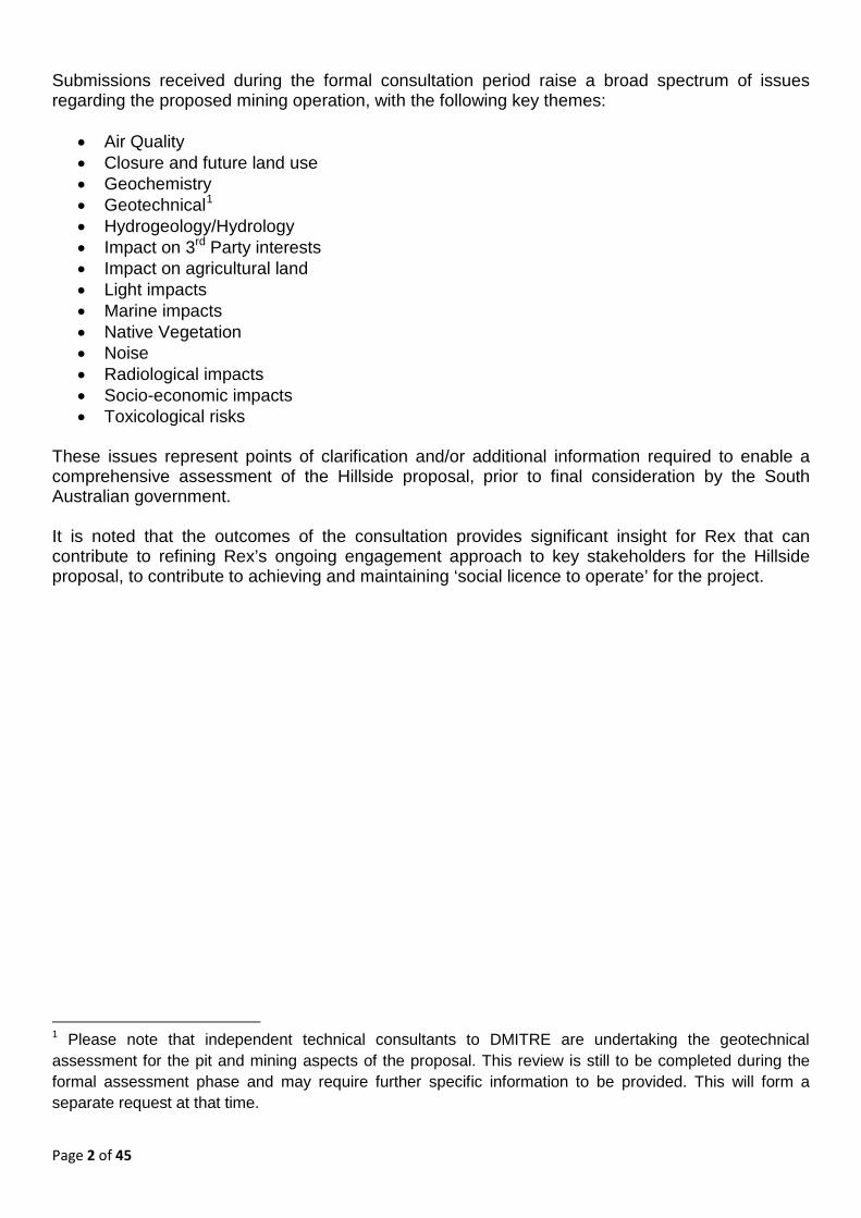
Page 2 of 45
Submissions received during the formal consultation period raise a broad spectrum of issues regarding the proposed mining operation, with the following key themes:
• Air Quality • Closure and future land use • Geochemistry • Geotechnical1 • Hydrogeology/Hydrology • Impact on 3rd Party interests • Impact on agricultural land • Light impacts • Marine impacts • Native Vegetation • Noise • Radiological impacts • Socio-economic impacts • Toxicological risks
These issues represent points of clarification and/or additional information required to enable a comprehensive assessment of the Hillside proposal, prior to final consideration by the South Australian government. It is noted that the outcomes of the consultation provides significant insight for Rex that can contribute to refining Rex’s ongoing engagement approach to key stakeholders for the Hillside proposal, to contribute to achieving and maintaining ‘social licence to operate’ for the project.
1 Please note that independent technical consultants to DMITRE are undertaking the geotechnical assessment for the pit and mining aspects of the proposal. This review is still to be completed during the formal assessment phase and may require further specific information to be provided. This will form a separate request at that time.
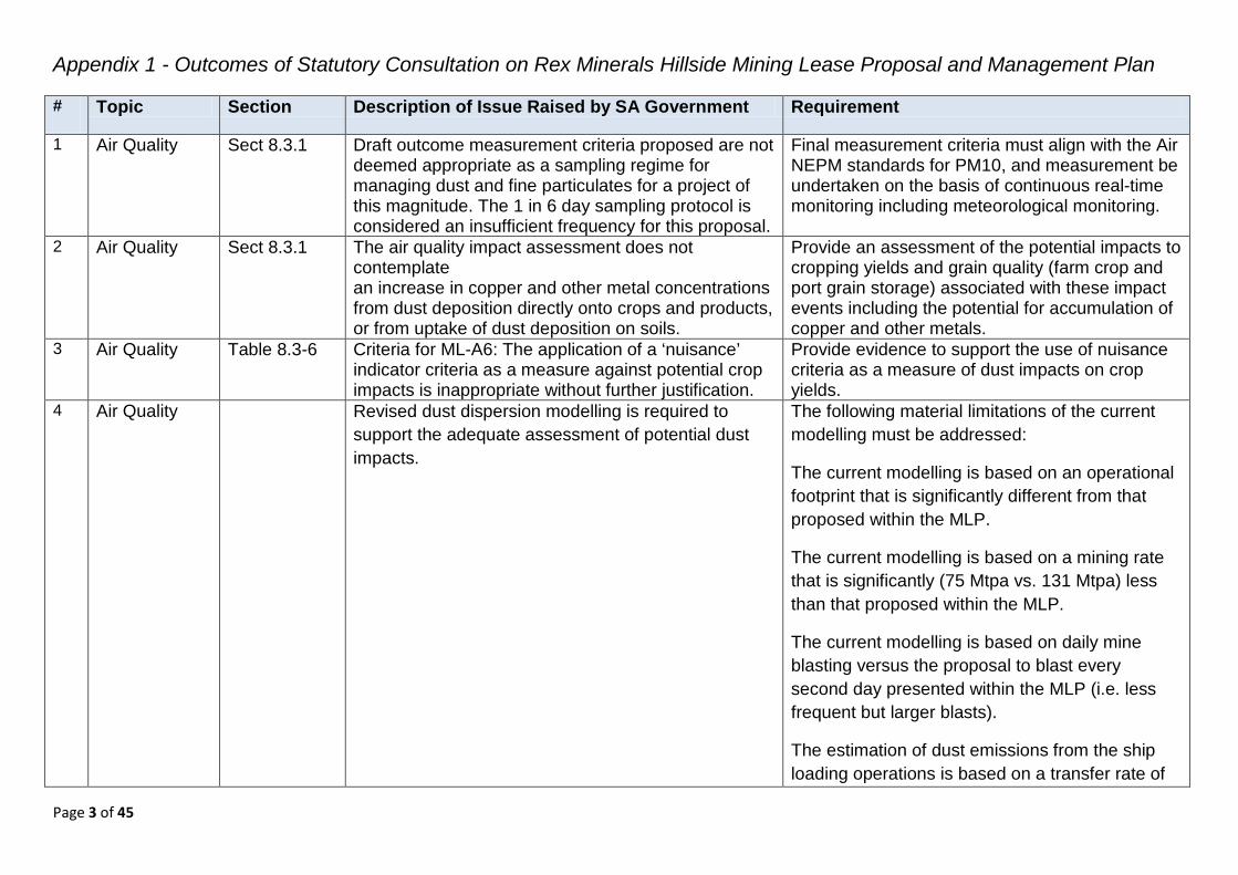
Appendix 1 - Outcomes of Statutory Consultation on Rex Minerals Hillside Mining Lease Proposal and Management Plan
Page 3 of 45
# Topic Section Description of Issue Raised by SA Government Requirement
1 Air Quality Sect 8.3.1 Draft outcome measurement criteria proposed are not deemed appropriate as a sampling regime for managing dust and fine particulates for a project of this magnitude. The 1 in 6 day sampling protocol is considered an insufficient frequency for this proposal.
Final measurement criteria must align with the Air NEPM standards for PM10, and measurement be undertaken on the basis of continuous real-time monitoring including meteorological monitoring.
2 Air Quality Sect 8.3.1 The air quality impact assessment does not contemplate an increase in copper and other metal concentrations from dust deposition directly onto crops and products, or from uptake of dust deposition on soils.
Provide an assessment of the potential impacts to cropping yields and grain quality (farm crop and port grain storage) associated with these impact events including the potential for accumulation of copper and other metals.
3 Air Quality Table 8.3-6 Criteria for ML-A6: The application of a ‘nuisance’ indicator criteria as a measure against potential crop impacts is inappropriate without further justification.
Provide evidence to support the use of nuisance criteria as a measure of dust impacts on crop yields.
4 Air Quality Revised dust dispersion modelling is required to support the adequate assessment of potential dust impacts.
The following material limitations of the current modelling must be addressed:
The current modelling is based on an operational footprint that is significantly different from that proposed within the MLP.
The current modelling is based on a mining rate that is significantly (75 Mtpa vs. 131 Mtpa) less than that proposed within the MLP.
The current modelling is based on daily mine blasting versus the proposal to blast every second day presented within the MLP (i.e. less frequent but larger blasts).
The estimation of dust emissions from the ship loading operations is based on a transfer rate of
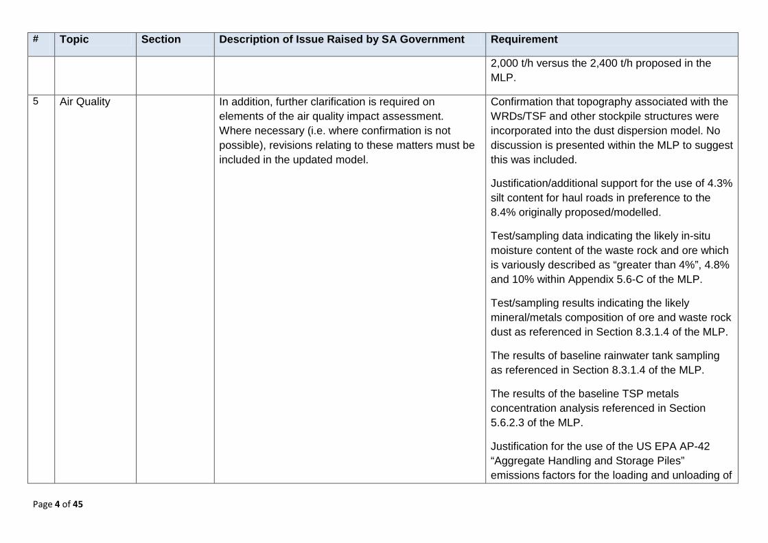
Page 4 of 45
# Topic Section Description of Issue Raised by SA Government Requirement
2,000 t/h versus the 2,400 t/h proposed in the MLP.
5 Air Quality In addition, further clarification is required on elements of the air quality impact assessment. Where necessary (i.e. where confirmation is not possible), revisions relating to these matters must be included in the updated model.
Confirmation that topography associated with the WRDs/TSF and other stockpile structures were incorporated into the dust dispersion model. No discussion is presented within the MLP to suggest this was included.
Justification/additional support for the use of 4.3% silt content for haul roads in preference to the 8.4% originally proposed/modelled.
Test/sampling data indicating the likely in-situ moisture content of the waste rock and ore which is variously described as “greater than 4%”, 4.8% and 10% within Appendix 5.6-C of the MLP.
Test/sampling results indicating the likely mineral/metals composition of ore and waste rock dust as referenced in Section 8.3.1.4 of the MLP.
The results of baseline rainwater tank sampling as referenced in Section 8.3.1.4 of the MLP.
The results of the baseline TSP metals concentration analysis referenced in Section 5.6.2.3 of the MLP.
Justification for the use of the US EPA AP-42 “Aggregate Handling and Storage Piles” emissions factors for the loading and unloading of
Page 5 of 45
# Topic Section Description of Issue Raised by SA Government Requirement
ore and waste rock material to/from haul trucks (Sections A.1.1.2 and A.1.8 of Appendix 5.6-C of the MLP) and in preference to other emissions factors such as those for haul truck unloading of overburden and the loading of overburden with excavators/shovels presented within Table 2 of the National Pollutant Inventory Emission Estimation Technique Manual for Mining (v3.1).
Confirmation that the 2,000 kg/t ship loading rate referenced in Table 11.41 of Appendix 5.6-C of the MLP is a typographical error, and that the rate assumed was actually 2,000 t/h (or 2400 t/h?).
Justification for limiting the location (and hence total length) of haul roads to the areas immediately surrounding the open pit and the southern extent of the Western WRD as shown in Figure 3.1 of Appendix 5.6-C of the MLP. In practice it is assumed that haul trucks will be required to travel via haul roads to tip points located all across the WRDs, potentially resulting in significantly greater haul road length than modelled, and potentially broader distribution of dust impacts. Justification sought that the modeling does represent worst case scenario for receptors.
Confirmation that the emissions estimation for wheel-generated dust included the total haul truck distance travelled per load, i.e. the distance
Page 6 of 45
# Topic Section Description of Issue Raised by SA Government Requirement
associated not only with the loaded truck traveling to tip points on the ROM stockpile and WRDs, but also including estimates of dust generation for the return (empty) trip back to the open pit operation.
Confirmation that wind erosion emissions from topsoil and subsoil stockpiles located adjacent to the open and surrounding the Western WRD (see Figure 6.5-12 of the MLP) were excluded from the modelling based on an assumption that successful revegetation would result in no erosion-based emissions.
Provision of details related to the design and operation of the primary crusher enclosure to allow an assessment of the appropriateness of the nominated crusher loading emission and dust control factor to be undertaken.
Justification for not including emission factors related to wind erosion for other (non-stockpile) cleared surfaces including haul road surfaces.
Discussion regarding the potential for dust and saline aerosol emissions from the installation and operation of underground raise ventilation bores.
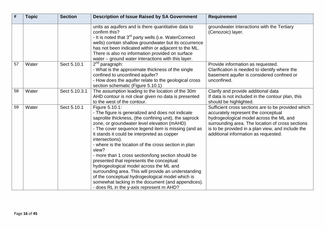
Justification for the failure to assess dust-related health impacts against relevant annual PM10, and 24-hour and annual PM2.5, criteria in accordance with the latest health science presented in the 2011 Ambient Air Quality NEPM

Page 7 of 45
# Topic Section Description of Issue Raised by SA Government Requirement
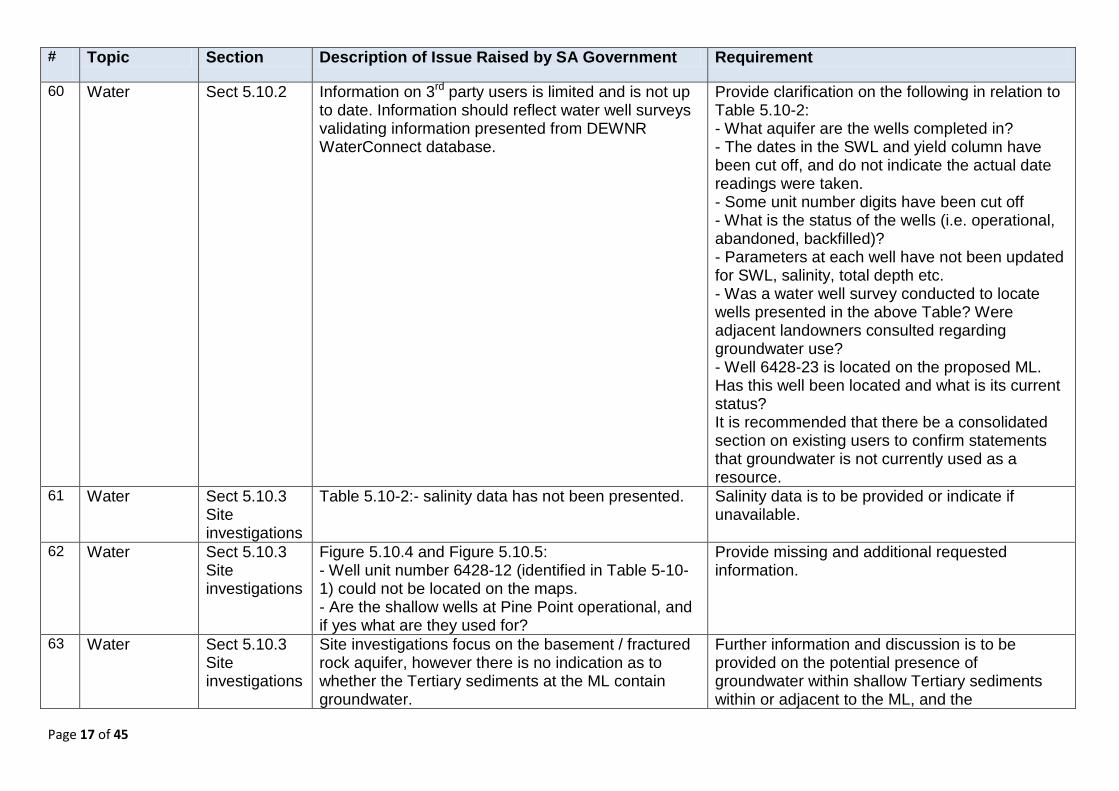
Review Report.
Justification for the use of annual average TSP and dust deposition as measures of potential impacts to amenity in preference to averaging periods of shorter duration (hourly/daily) which may better reflect the likely conditions that will effect individuals/communities perceptions of dust.
The provision of additional information as required to give context to the modelled dust deposition rates and the toxicological properties of the dust, such as data to allow the comparison of predicted rates and concentrations against standards, guidelines and/or other sources of ‘exposure-response’ data for each identified potential impact to allow the likely impacts of the Project to be quantified (e.g. a comparison of the likely build-up of copper in rainwater tanks against the Australian Drinking Water Guidelines criteria for copper and/or the predicted concentration of copper in stored grain against food consumption-related criteria taking into account the rate of turnover of the grain storages etc).
6 Closure Sect 6.9 Mine Completion
Figure 6.9-8: The vertical units (z) are difficult to interpret for cross section A:A; B:B, C:C. Do the units 0Z and 1000Z refer to ground level or m AHD?
Provide clarification on the vertical units reference datum being used.
7 Closure 6.9.4.4 Process for closure does not identify the modelling uncertainty of pit lake water level return post closure.
Provide clarification of uncertainty around the modelled rate of pit water recovery and impact this may have on the return of pit water levels

Page 8 of 45
# Topic Section Description of Issue Raised by SA Government Requirement
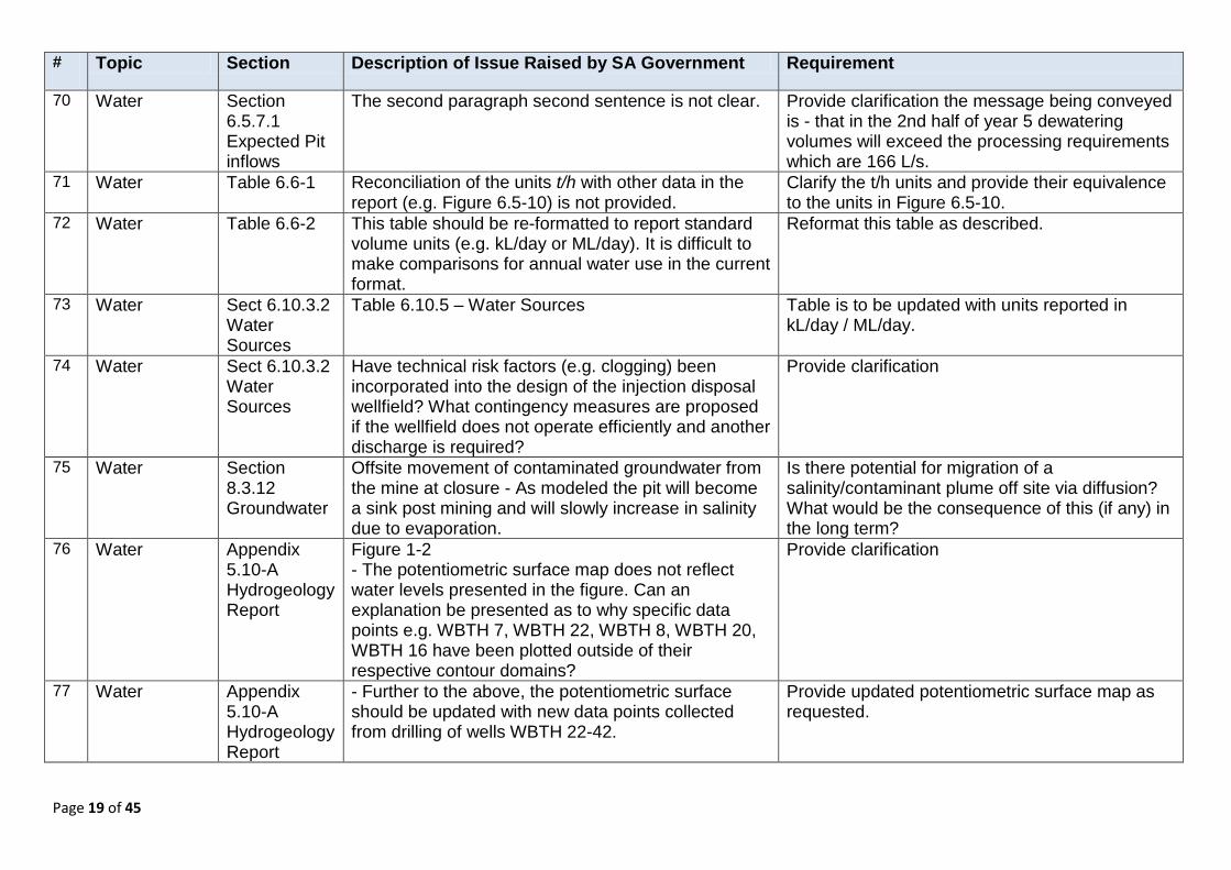
post mining. Provide assessment of pit lake water chemistry post- closure.
8 Closure 6.9.5.1 It is unclear what will be used to fill the pipeline at closure.
Provide clarification
9 Closure Sect 6.9 Mine Completion And Sect 8.3.14.3 Control and Management Strategies (Public Safety) Sect 8.3.17.3 Control and Management Strategies (Adjacent land use) Sect 8.3.18 Protection of Third Party Property (ML)
The post closure impact to third party property has not been addressed, specifically in relation to the long term stability of the pit wall (and pit wall surface expression), and the risk of subsidence of the UG mine in the long term on the following: a) Third Party Property b) Public Roads c) Waste rock dumps post closure d) Tailings storage facility post closure
Provide a detailed assessment addressing the outlined potential post closure impacts associated with geotechnical stability. The assessment should discuss any uncertainties around the residual risk for the predicted post-closure impacts. Provide confirmation that the final pit outline as shown in Figures 6.9-6 to 6.9-10 represent the final pit outline at the cessation of mining - not the long term geotechnically stable pit outline post closure.
10 Concentrate Characterisation of the copper concentrate is not clear.
Provide a full chemical composition and mineral speciation of the copper concentrate (e.g. MSDS).
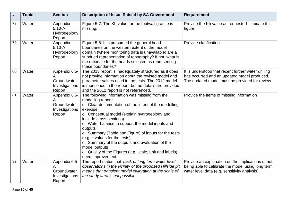
11 Editorial Section 6.4.2.1
Terms for waste rock dumps ‘Northern’ and ‘Southern’ are used in the text but mine site layout figures (6.4-3 and 6.4-4) refer to North Eastern and
Provide clarification
Page 9 of 45
# Topic Section Description of Issue Raised by SA Government Requirement
South Eastern WRD. 12 Editorial There is reference within the document and
appendices of an Air Quality Management Plan and a Dust Management and Monitoring Plan – are these proposed to be separate documents with different contents?
Provide clarification
13 Editorial 5.10.2 Non-specific terms are used to describe groundwater well depths, salinity and quality.
Specific values for water quality, depths and ranges should be used to describe the hydrogeological setting.
14 Editorial 6.6.6.5 Figure number missing at end of paragraph. Provide
15 Geochemistry Sect 6.7 Waste
Table 6-7-3 - Classification of rock types: In the lithology column breccia (pyritic) has been classed as ACM (acid consuming).
What is the rationale for classifying this rock type as ACM, given FeS2 minerals are present?
16 Geochemistry Section 8.3.11 Surface water
Table 8.3-45 ID ML-SW6: There is no comment in relation to the mobilisation of copper in oxidised waters.
Provide further information regarding mobilisation of copper in oxidised waters. Geochemically, what is the likely state of water that percolates through copper-oxide stockpiles? Is copper likely to be transported in oxidised runoff?
17 Geochemistry 6.5.8.5 How has the determination that soils and subsoil stockpiles are benign been concluded.
Provide clarification
18 Geochemistry Additional data is required to undertake an assessment of geochemical risks to the environment posed by the proposed mining project.
The following information is required : The drillhole database for waste rock and ore - in particular the raw data of sulfur and other metals that may be contained within the ore and host rocks to get a understanding on the distribution and concentration of these attributes; The sulfur block modelling report; The geology report on the host rock and ore including mineralogy (It is noted that the ore has elevated acid neutralising capacity; but only one sample analysis has been provided. It is necessary to get a understanding of the variance in concentration of sulfides that may report to the
Page 10 of 45
# Topic Section Description of Issue Raised by SA Government Requirement
TSF and waste rock facility). The mine waste characterisation data from the second round of sampling - 125 samples (the report has been provided but not raw data).
19 Geology Sect 5.8.1.2 Faults: Given the deposit is in a major structural corridor, what is the potential for fault movement / seismicity related to blasting and stress redistribution as a result of the open pit mining and sublevel stoping?
Further information to be provided on the potential for fault movement / seismicity related to blasting and stress redistribution as a result of the open pit mining and sublevel stoping?
20 Geology Sect 5.8.3 The terminology in the 4th paragraph is too general i.e. leachate testwork on samples from Hillside indicate that the leachate from samples is relatively benign, and that waste rock leachate is unlikely to present a significant risk to the environment.
What are the key parameters that are lacking that would allow a more definitive statement?
21 Geology Sect 5.8.3 (5th paragraph): The risk associated with atacamite’s solubility in rainwater is not described? How will the oxide stockpile be managed to contain this risk?
Additional information to be provided on the risk associated with atacamite’s solubility in rainwater, and how the oxide stockpile will be managed to contain this risk?
22 Geology Sect 5.16.4 Geological monuments
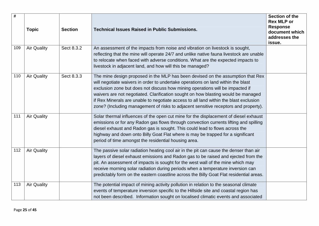
There are two listed coastal geological monuments listed as on the coast, adjacent to the proposed development site. These are Harts Mine (YK5) and Muloowurtie Formation (YK6).
Confirm the presence of both of these sites on a plan (currently Section 5.16.4 does not mention Muloowurtie Formation).
23 Geology Section 6.2 Reserves, Products and Markets
The resource to be accessed with underground development is not shown in the proposal.
A plan is required to show the reserve and resource limits in relation to the proposed pit outline and underground workings and the ore reserve statement provided in the MLP.
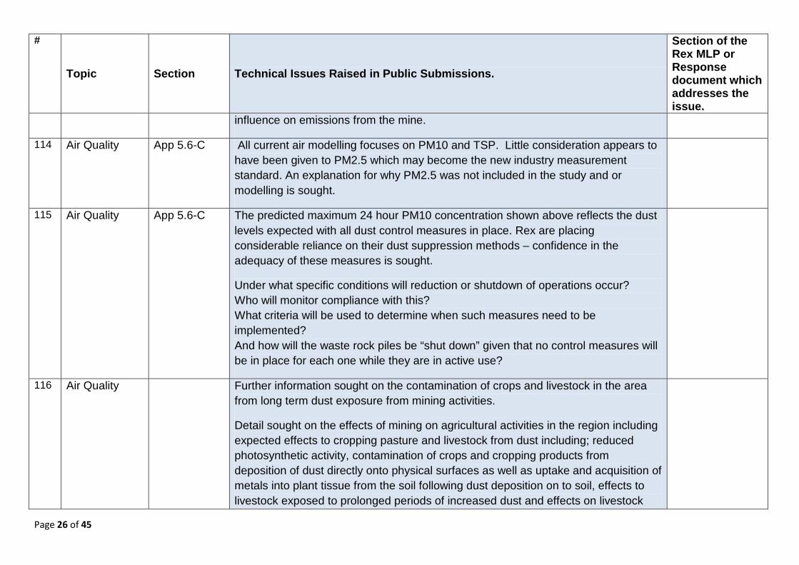
24 Geology General No information is provided to assess any sterilisation of potential resource areas under waste dump, tailings storage facility or other infrastructure areas. Exploration drilling may have established that no potentially economic mineralisation is present in these areas but the relevant drilling information has not been presented.
Evidence that potential for sterilisation has been minimised through exploration drilling.

Page 11 of 45
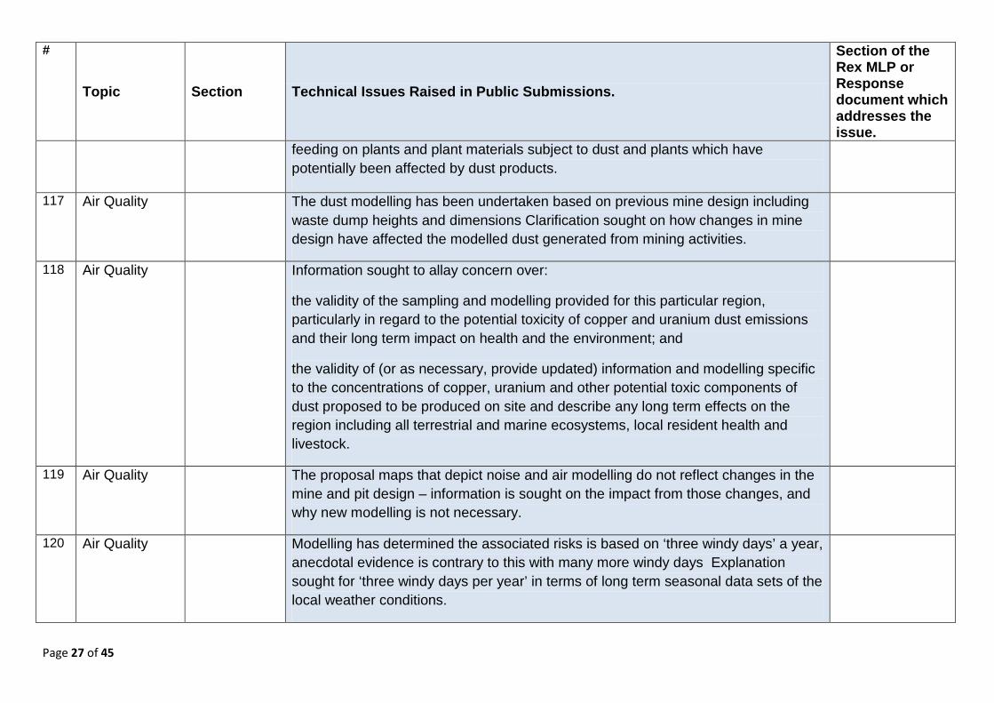
# Topic Section Description of Issue Raised by SA Government Requirement
25 Geology Section 6.2 Geological environment
Description in the MLP of the post Proterozoic geology is very brief and interspersed. It is difficult to undertake an assessment of geotechnical risks based on the information provided.
Further detailed interpretation is required about post-Proterozoic geology of the area.
26 Geology 8.3.12.4 The document (Page 8-176 and Page 8-174) appears to provide contradictory statements regarding the competency of the coastal granites and therefore the barrier to seawater ingress.
Clarify the competency of the coastal granites and the potential fractures or faults within them.
27 Geology Sect 1.2 The mining rate of 15 Mt/annum has been projected for ~15 years giving a total mass extracted of 225 Mt. How does this relate to the stated resource of 337 M/t which would extend the operation to ~22 years?
Clarification is to be provided on the total reserve to be mined, proposed production rates and mine life.
28 Geotechnical 8.3.13.2 It is not clear if potential structural / geotechnical issues due to TSF seepage have been assessed.
Provide information on the influence of base seepage from the TSF on the stability of the open pit.
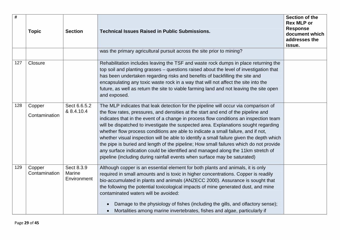
29 Geotechnical General Additional data is required to undertake a complete assessment of geotechnical risks to the environment posed by the proposed mining project.
Provide: (i) All available technical reports relating to: • mine geology • groundwater • open pit geotechnical conditions • open pit wall and mine design (including pit wall angles) • underground geotechnical conditions • underground development and stope design. (ii) Core logs, core photographs and borehole survey data for geotechnical boreholes. (iii) Borehole survey data for other boreholes in mine area (i.e.: collar locations) (iv) 3D wireframes or string files for: • topography • base of saprolite • base of oxidation • base of transition • ore lodes • geological contacts • Pine Point Fault and any other major faults • starter pits, pushback 1 pit, pushback 2 pit, final pit • waste dumps and tailings storage • underground development and stoping layout • proposed surface layout,
Page 12 of 45
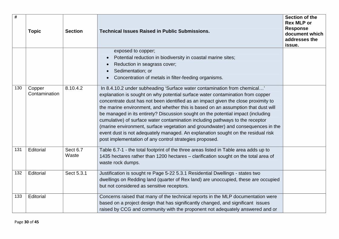
# Topic Section Description of Issue Raised by SA Government Requirement
including lease boundary, processing plant, road deviations. These files should be provided in Surpac or DXF formats.
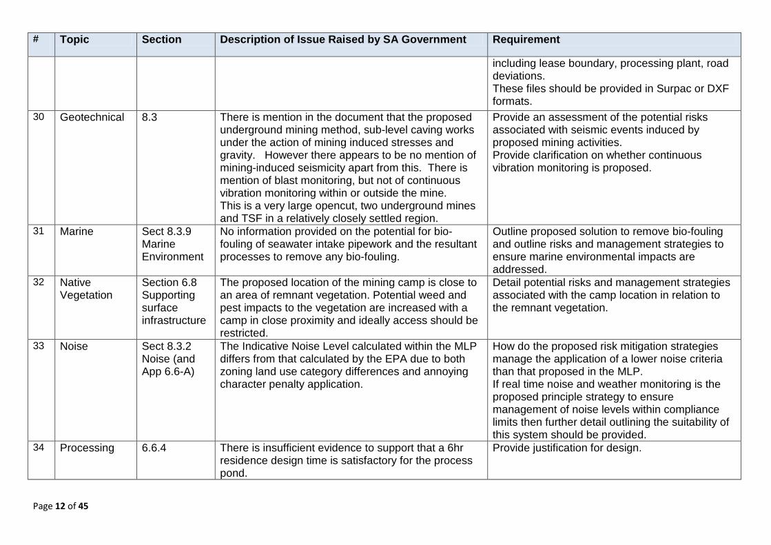
30 Geotechnical 8.3 There is mention in the document that the proposed underground mining method, sub-level caving works under the action of mining induced stresses and gravity. However there appears to be no mention of mining-induced seismicity apart from this. There is mention of blast monitoring, but not of continuous vibration monitoring within or outside the mine. This is a very large opencut, two underground mines and TSF in a relatively closely settled region.
Provide an assessment of the potential risks associated with seismic events induced by proposed mining activities. Provide clarification on whether continuous vibration monitoring is proposed.
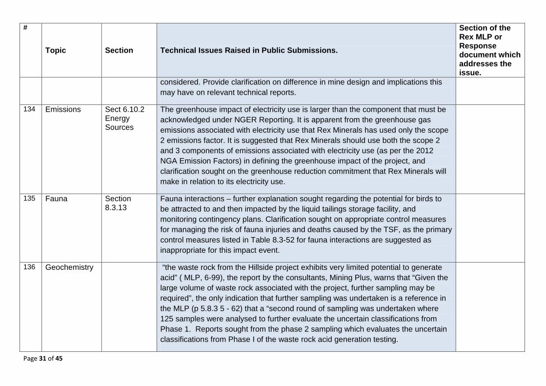
31 Marine Sect 8.3.9 Marine Environment
No information provided on the potential for bio-fouling of seawater intake pipework and the resultant processes to remove any bio-fouling.
Outline proposed solution to remove bio-fouling and outline risks and management strategies to ensure marine environmental impacts are addressed.
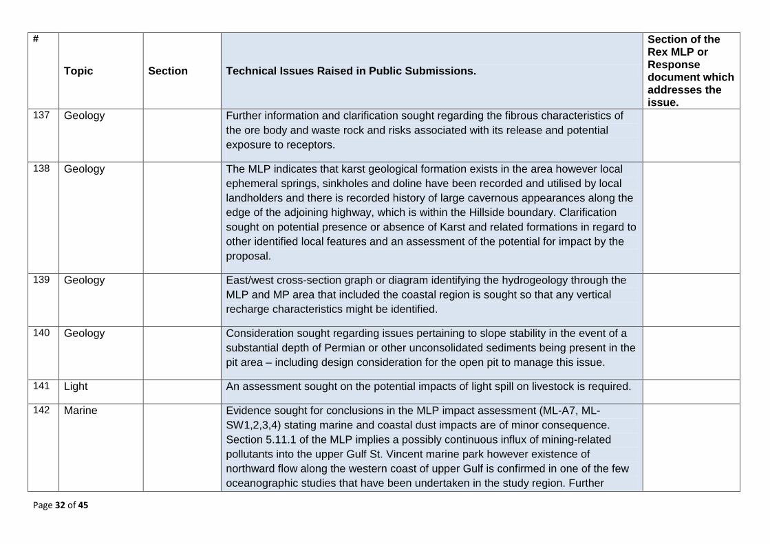
32 Native Vegetation
Section 6.8 Supporting surface infrastructure
The proposed location of the mining camp is close to an area of remnant vegetation. Potential weed and pest impacts to the vegetation are increased with a camp in close proximity and ideally access should be restricted.
Detail potential risks and management strategies associated with the camp location in relation to the remnant vegetation.
33 Noise Sect 8.3.2 Noise (and App 6.6-A)
The Indicative Noise Level calculated within the MLP differs from that calculated by the EPA due to both zoning land use category differences and annoying character penalty application.
How do the proposed risk mitigation strategies manage the application of a lower noise criteria than that proposed in the MLP. If real time noise and weather monitoring is the proposed principle strategy to ensure management of noise levels within compliance limits then further detail outlining the suitability of this system should be provided.
34 Processing 6.6.4 There is insufficient evidence to support that a 6hr residence design time is satisfactory for the process pond.
Provide justification for design.
Page 13 of 45
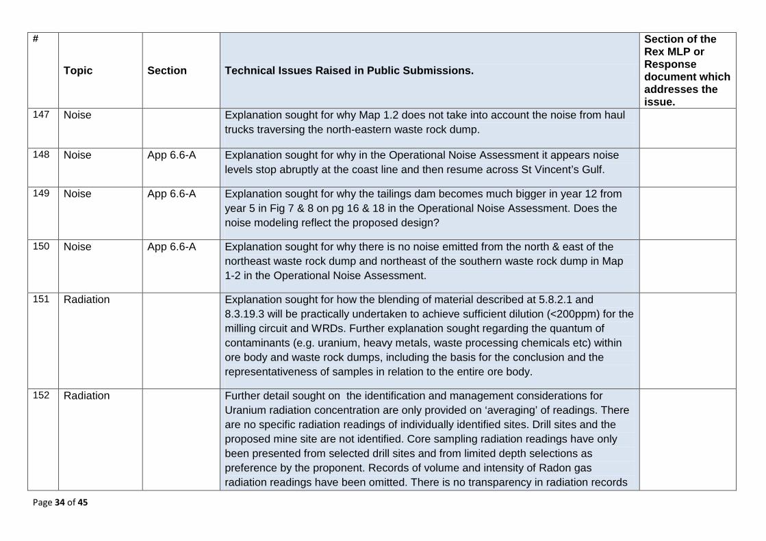
# Topic Section Description of Issue Raised by SA Government Requirement
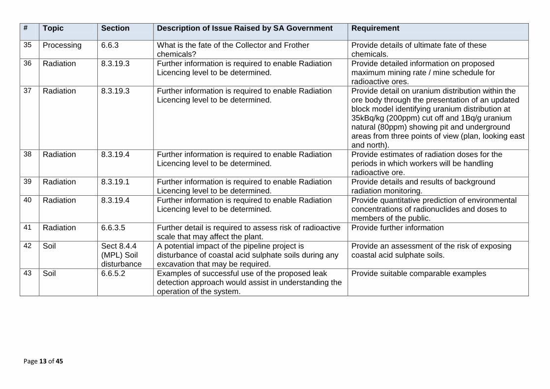
35 Processing 6.6.3 What is the fate of the Collector and Frother chemicals?
Provide details of ultimate fate of these chemicals.
36 Radiation 8.3.19.3 Further information is required to enable Radiation Licencing level to be determined.
Provide detailed information on proposed maximum mining rate / mine schedule for radioactive ores.
37 Radiation 8.3.19.3 Further information is required to enable Radiation Licencing level to be determined.
Provide detail on uranium distribution within the ore body through the presentation of an updated block model identifying uranium distribution at 35kBq/kg (200ppm) cut off and 1Bq/g uranium natural (80ppm) showing pit and underground areas from three points of view (plan, looking east and north).
38 Radiation 8.3.19.4 Further information is required to enable Radiation Licencing level to be determined.
Provide estimates of radiation doses for the periods in which workers will be handling radioactive ore.
39 Radiation 8.3.19.1 Further information is required to enable Radiation Licencing level to be determined.
Provide details and results of background radiation monitoring.
40 Radiation 8.3.19.4 Further information is required to enable Radiation Licencing level to be determined.
Provide quantitative prediction of environmental concentrations of radionuclides and doses to members of the public.
41 Radiation 6.6.3.5 Further detail is required to assess risk of radioactive scale that may affect the plant.
Provide further information
42 Soil Sect 8.4.4 (MPL) Soil disturbance
A potential impact of the pipeline project is disturbance of coastal acid sulphate soils during any excavation that may be required.
Provide an assessment of the risk of exposing coastal acid sulphate soils.
43 Soil 6.6.5.2 Examples of successful use of the proposed leak detection approach would assist in understanding the operation of the system.
Provide suitable comparable examples
Page 14 of 45
# Topic Section Description of Issue Raised by SA Government Requirement
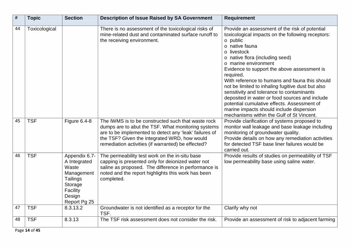
44 Toxicological There is no assessment of the toxicological risks of mine-related dust and contaminated surface runoff to the receiving environment.
Provide an assessment of the risk of potential toxicological impacts on the following receptors: o public o native fauna o livestock o native flora (including seed) o marine environment Evidence to support the above assessment is required. With reference to humans and fauna this should not be limited to inhaling fugitive dust but also sensitivity and tolerance to contaminants deposited in water or food sources and include potential cumulative effects. Assessment of marine impacts should include dispersion mechanisms within the Gulf of St Vincent.
45 TSF Figure 6.4-8 The IWMS is to be constructed such that waste rock dumps are to abut the TSF. What monitoring systems are to be implemented to detect any ‘leak’ failures of the TSF? Given the integrated WRD, how would remediation activities (if warranted) be effected?
Provide clarification of systems proposed to monitor wall leakage and base leakage including monitoring of groundwater quality. Provide details on how any remediation activities for detected TSF base liner failures would be carried out.
46 TSF Appendix 6.7-A Integrated Waste Management Tailings Storage Facility Design Report Pg 25
The permeability test work on the in-situ base capping is presented only for deionized water not saline as proposed. The difference in performance is noted and the report highlights this work has been completed.
Provide results of studies on permeability of TSF low permeability base using saline water.
47 TSF 8.3.13.2 Groundwater is not identified as a receptor for the TSF.
Clarify why not
48 TSF 8.3.13 The TSF risk assessment does not consider the risk. Provide an assessment of risk to adjacent farming
Page 15 of 45
# Topic Section Description of Issue Raised by SA Government Requirement
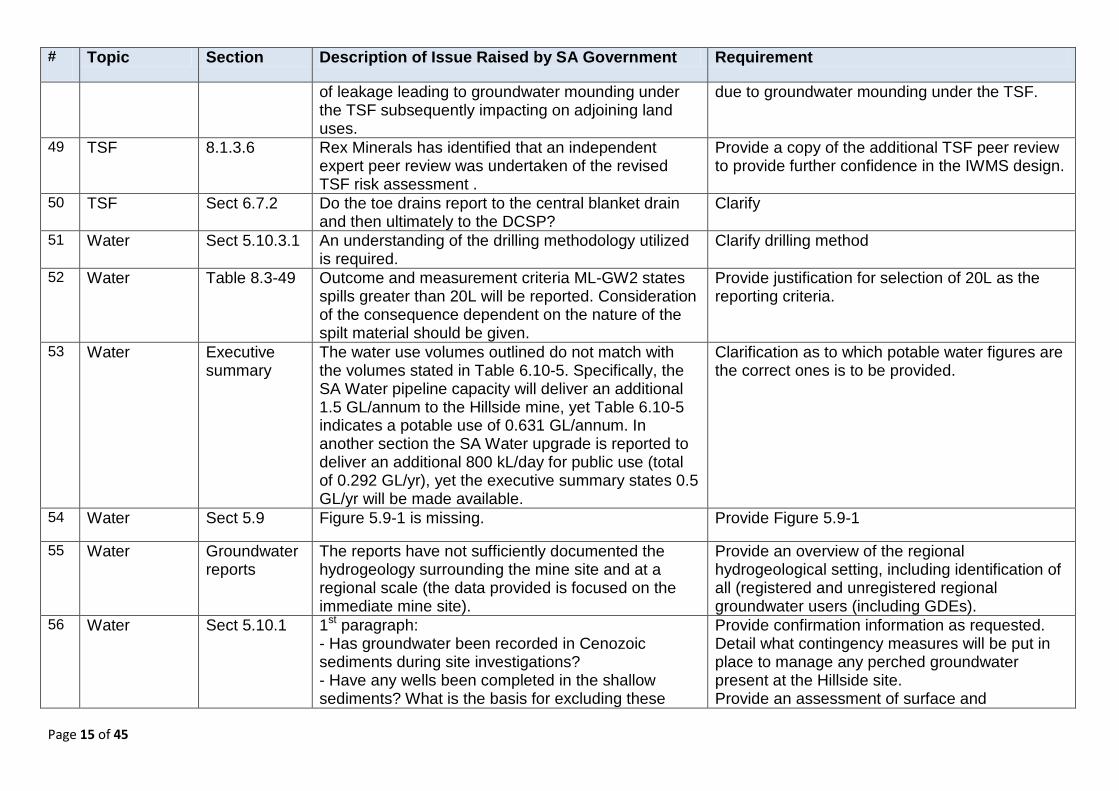
of leakage leading to groundwater mounding under the TSF subsequently impacting on adjoining land uses.
due to groundwater mounding under the TSF.
49 TSF 8.1.3.6 Rex Minerals has identified that an independent expert peer review was undertaken of the revised TSF risk assessment .
Provide a copy of the additional TSF peer review to provide further confidence in the IWMS design.
50 TSF Sect 6.7.2 Do the toe drains report to the central blanket drain and then ultimately to the DCSP?
Clarify
51 Water Sect 5.10.3.1 An understanding of the drilling methodology utilized is required.
Clarify drilling method
52 Water Table 8.3-49 Outcome and measurement criteria ML-GW2 states spills greater than 20L will be reported. Consideration of the consequence dependent on the nature of the spilt material should be given.
Provide justification for selection of 20L as the reporting criteria.
53 Water Executive summary
The water use volumes outlined do not match with the volumes stated in Table 6.10-5. Specifically, the SA Water pipeline capacity will deliver an additional 1.5 GL/annum to the Hillside mine, yet Table 6.10-5 indicates a potable use of 0.631 GL/annum. In another section the SA Water upgrade is reported to deliver an additional 800 kL/day for public use (total of 0.292 GL/yr), yet the executive summary states 0.5 GL/yr will be made available.
Clarification as to which potable water figures are the correct ones is to be provided.
54 Water Sect 5.9 Figure 5.9-1 is missing. Provide Figure 5.9-1
55 Water Groundwater reports
The reports have not sufficiently documented the hydrogeology surrounding the mine site and at a regional scale (the data provided is focused on the immediate mine site).
Provide an overview of the regional hydrogeological setting, including identification of all (registered and unregistered regional groundwater users (including GDEs).
56 Water Sect 5.10.1 1st paragraph: - Has groundwater been recorded in Cenozoic sediments during site investigations? - Have any wells been completed in the shallow sediments? What is the basis for excluding these
Provide confirmation information as requested. Detail what contingency measures will be put in place to manage any perched groundwater present at the Hillside site. Provide an assessment of surface and
Page 16 of 45
# Topic Section Description of Issue Raised by SA Government Requirement
units as aquifers and is there quantitative data to confirm this? - It is noted that 3rd party wells (i.e. WaterConnect wells) contain shallow groundwater but its occurrence has not been indicated within or adjacent to the ML. There is also no information provided on surface water – ground water interactions with this layer.
groundwater interactions with the Tertiary (Cenozoic) layer.
57 Water Sect 5.10.1 2nd paragraph: - What is the approximate thickness of the single confined to unconfined aquifer? - How does the aquifer relate to the geological cross section schematic (Figure 5.10.1)
Provide information as requested. Clarification is needed to identify where the basement aquifer is considered confined or unconfined.
58 Water Sect 5.10.3.1 The assumption leading to the location of the 30m AHD contour is not clear given no data is presented to the west of the contour.
Clarify and provide additional data If data is not included in the contour plan, this should be highlighted.
59 Water Sect 5.10.1 Figure 5.10.1: - The figure is generalized and does not indicate saprolite thickness, (the confining unit), the saprock zone, or groundwater level elevation (mAHD) - The cover sequence legend item is missing (and as it stands it could be interpreted as copper intersections). - where is the location of the cross section in plan view? - more than 1 cross section/long section should be presented that represents the conceptual hydrogeological model across the ML and surrounding area. This will provide an understanding of the conceptual hydrogeological model which is somewhat lacking in the document (and appendices). - does RL in the y-axis represent m AHD?
Sufficient cross sections are to be provided which accurately represent the conceptual hydrogeological model across the ML and surrounding area. The location of cross sections is to be provided in a plan view, and include the additional information as requested.
Page 17 of 45
# Topic Section Description of Issue Raised by SA Government Requirement
60 Water Sect 5.10.2 Information on 3rd party users is limited and is not up to date. Information should reflect water well surveys validating information presented from DEWNR WaterConnect database.
Provide clarification on the following in relation to Table 5.10-2: - What aquifer are the wells completed in? - The dates in the SWL and yield column have been cut off, and do not indicate the actual date readings were taken. - Some unit number digits have been cut off - What is the status of the wells (i.e. operational, abandoned, backfilled)? - Parameters at each well have not been updated for SWL, salinity, total depth etc. - Was a water well survey conducted to locate wells presented in the above Table? Were adjacent landowners consulted regarding groundwater use? - Well 6428-23 is located on the proposed ML. Has this well been located and what is its current status? It is recommended that there be a consolidated section on existing users to confirm statements that groundwater is not currently used as a resource.
61 Water Sect 5.10.3 Site investigations
Table 5.10-2:- salinity data has not been presented. Salinity data is to be provided or indicate if unavailable.
62 Water Sect 5.10.3 Site investigations
Figure 5.10.4 and Figure 5.10.5: - Well unit number 6428-12 (identified in Table 5-10-1) could not be located on the maps. - Are the shallow wells at Pine Point operational, and if yes what are they used for?
Provide missing and additional requested information.
63 Water Sect 5.10.3 Site investigations
Site investigations focus on the basement / fractured rock aquifer, however there is no indication as to whether the Tertiary sediments at the ML contain groundwater.
Further information and discussion is to be provided on the potential presence of groundwater within shallow Tertiary sediments within or adjacent to the ML, and the

Page 18 of 45
# Topic Section Description of Issue Raised by SA Government Requirement
characteristics of the shallow aquifer. 64 Water Sect 5.10.3 - The 2nd paragraph on page 5-76 states that limited
localized recharge may occur at Hillside by seepage through the saprolitic confining layer, but there is no indication as to where this may occur or its significance (given limited information presented for the cover sediments).
Provide clarification
65 Water Sect 5.10.3 Site investigations
Figure 5.10-7: - Data points for standing water levels do not all correspond with the contour value indicated on the potentiometric surface e.g. WBTH-31 plots within the 20-25 m contour interval, yet reports at RSWL of 30.8 mAHD.
Clarify the rationale for this.
66 Water Sect 5.10.4 Environmental value
Section 5.10.4.1 – Environmental Value: The threshold salinity value of “industrial” (i.e. value in mg/L) should be incorporated into the paragraph to make the statement more quantitative.
Provide a threshold salinity value for the ‘industrial’ category of environmental value.
67 Water Sect 5.10.4.2 Environmental value
Section 5.10.4.2 – Groundwater Dependent Ecosystems: The BOM website indicates the potential presence of vegetation dependent on groundwater near the coast, presumed to be within shallow alluvium. Land surface contours indicate the vegetation systems correspond to the bottom end of a drainage line that will be disrupted by the open pit.
Was this vegetation patch inspected and is there an associated impact from reduction in surface runoff or shallow through-flow during pit development?
68 Water Sect 6.3.1.1 Exploration activities
What is Rex’s independent water supply? Provide information on the mentioned independent water supply.
69 Water Sections 6.3.2.1 and 6.3.2.2 Exploration activities
Rehabilitation of drillholes: Proposed decommissioning of drillholes is not in accordance with M21 document. Existence of multiple aquifers is presented in Section 5, yet not acknowledged in this section.
Provide information to demonstrate that drillhole rehabilitation is in accordance with Guideline M21.
Page 19 of 45
# Topic Section Description of Issue Raised by SA Government Requirement
70 Water Section 6.5.7.1 Expected Pit inflows
The second paragraph second sentence is not clear. Provide clarification the message being conveyed is - that in the 2nd half of year 5 dewatering volumes will exceed the processing requirements which are 166 L/s.
71 Water Table 6.6-1 Reconciliation of the units t/h with other data in the report (e.g. Figure 6.5-10) is not provided.
Clarify the t/h units and provide their equivalence to the units in Figure 6.5-10.
72 Water Table 6.6-2 This table should be re-formatted to report standard volume units (e.g. kL/day or ML/day). It is difficult to make comparisons for annual water use in the current format.
Reformat this table as described.
73 Water Sect 6.10.3.2 Water Sources
Table 6.10.5 – Water Sources Table is to be updated with units reported in kL/day / ML/day.
74 Water Sect 6.10.3.2 Water Sources
Have technical risk factors (e.g. clogging) been incorporated into the design of the injection disposal wellfield? What contingency measures are proposed if the wellfield does not operate efficiently and another discharge is required?
Provide clarification
75 Water Section 8.3.12 Groundwater
Offsite movement of contaminated groundwater from the mine at closure - As modeled the pit will become a sink post mining and will slowly increase in salinity due to evaporation.
Is there potential for migration of a salinity/contaminant plume off site via diffusion? What would be the consequence of this (if any) in the long term?
76 Water Appendix 5.10-A Hydrogeology Report
Figure 1-2 - The potentiometric surface map does not reflect water levels presented in the figure. Can an explanation be presented as to why specific data points e.g. WBTH 7, WBTH 22, WBTH 8, WBTH 20, WBTH 16 have been plotted outside of their respective contour domains?
Provide clarification
77 Water Appendix 5.10-A Hydrogeology Report
- Further to the above, the potentiometric surface should be updated with new data points collected from drilling of wells WBTH 22-42.
Provide updated potentiometric surface map as requested.
Page 20 of 45
# Topic Section Description of Issue Raised by SA Government Requirement
78 Water Appendix 5.10-A Hydrogeology Report
Figure 5-7: The Kh value for the footwall granite is missing.
Provide the Kh value as requested – update this figure.
79 Water Appendix 5.10-A Hydrogeology Report
Figure 5-8: It is presumed the general head boundaries on the western extent of the model domain (where monitoring data is unavailable) are a subdued representation of topography? If not, what is the rationale for the heads selected as representing these boundaries?
Provide clarification
80 Water Appendix 6.5-A Groundwater Investigations Report
The 2013 report is inadequately structured as it does not provide information about the revised model and parameter values used in the tests. The 2012 model is mentioned in the report, but no details are provided and the 2012 report is not referenced.
It is understood that recent further water drilling has occurred and an updated model produced. The updated model must be provided for review.
81 Water Appendix 6.5-A Groundwater Investigations Report
The following information was missing from the modelling report: o Clear documentation of the intent of the modelling exercise o Conceptual model (explain hydrogeology and include cross-sections) o Water balance to support the model inputs and outputs o Summary (Table and Figure) of inputs for the tests (e.g. k values for the tests) o Summary of the outputs and evaluation of the model outputs o Quality of the Figures (e.g. scale, unit and labels) need improvement.
Provide the items of missing information
82 Water Appendix 6.5-A Groundwater Investigations Report
The report states that 'Lack of long term water level observations in the vicinity of the proposed Hillside pit means that transient model calibration at the scale of the study area is not possible'.
Provide an explanation on the implications of not being able to calibrate the model using long term water level data (e.g. sensitivity analysis).
Page 21 of 45
# Topic Section Description of Issue Raised by SA Government Requirement
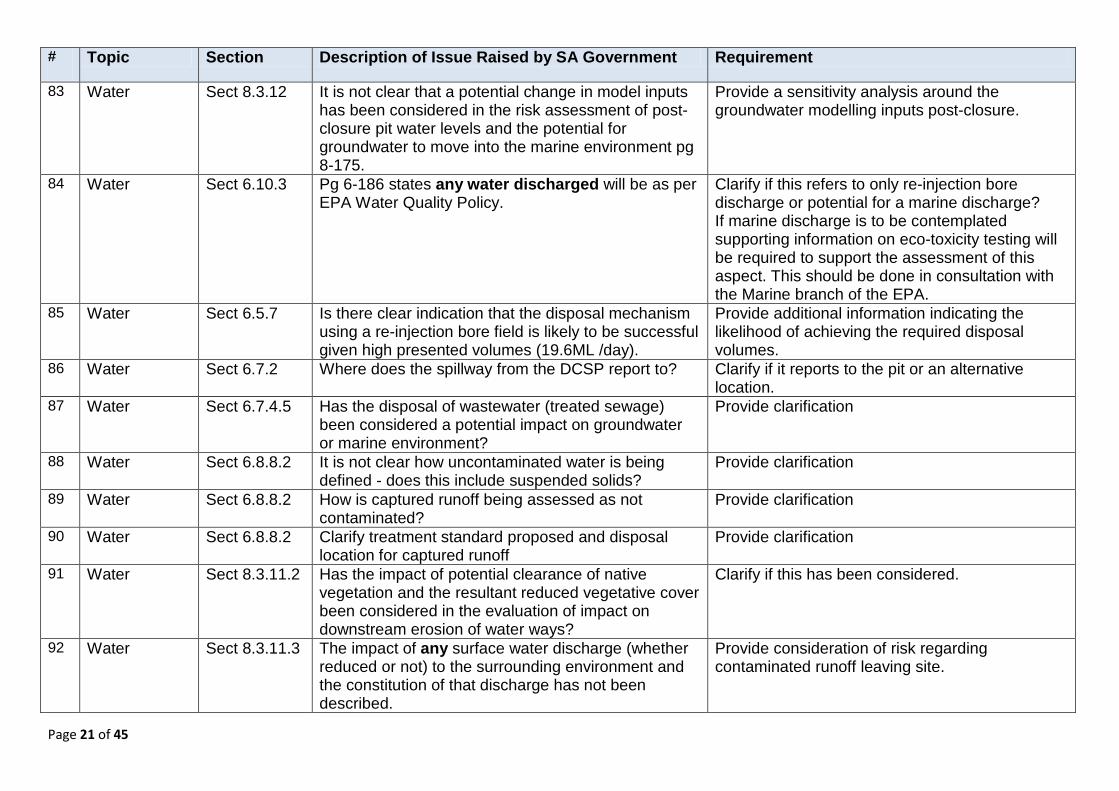
83 Water Sect 8.3.12 It is not clear that a potential change in model inputs has been considered in the risk assessment of post-closure pit water levels and the potential for groundwater to move into the marine environment pg 8-175.
Provide a sensitivity analysis around the groundwater modelling inputs post-closure.
84 Water Sect 6.10.3 Pg 6-186 states any water discharged will be as per EPA Water Quality Policy.
Clarify if this refers to only re-injection bore discharge or potential for a marine discharge? If marine discharge is to be contemplated supporting information on eco-toxicity testing will be required to support the assessment of this aspect. This should be done in consultation with the Marine branch of the EPA.
85 Water Sect 6.5.7 Is there clear indication that the disposal mechanism using a re-injection bore field is likely to be successful given high presented volumes (19.6ML /day).
Provide additional information indicating the likelihood of achieving the required disposal volumes.
86 Water Sect 6.7.2 Where does the spillway from the DCSP report to? Clarify if it reports to the pit or an alternative location.
87 Water Sect 6.7.4.5 Has the disposal of wastewater (treated sewage) been considered a potential impact on groundwater or marine environment?
Provide clarification
88 Water Sect 6.8.8.2 It is not clear how uncontaminated water is being defined - does this include suspended solids?
Provide clarification
89 Water Sect 6.8.8.2 How is captured runoff being assessed as not contaminated?
Provide clarification
90 Water Sect 6.8.8.2 Clarify treatment standard proposed and disposal location for captured runoff
Provide clarification
91 Water Sect 8.3.11.2 Has the impact of potential clearance of native vegetation and the resultant reduced vegetative cover been considered in the evaluation of impact on downstream erosion of water ways?
Clarify if this has been considered.
92 Water Sect 8.3.11.3 The impact of any surface water discharge (whether reduced or not) to the surrounding environment and the constitution of that discharge has not been described.
Provide consideration of risk regarding contaminated runoff leaving site.
Page 22 of 45
# Topic Section Description of Issue Raised by SA Government Requirement
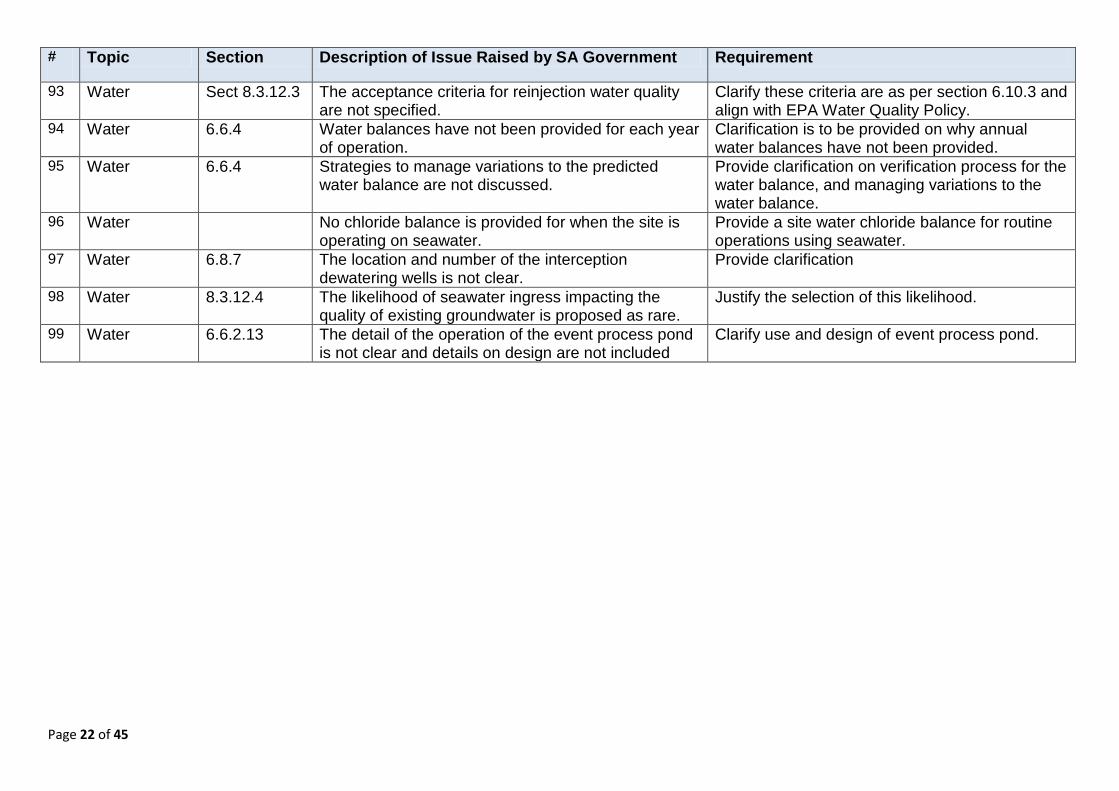
93 Water Sect 8.3.12.3 The acceptance criteria for reinjection water quality are not specified.
Clarify these criteria are as per section 6.10.3 and align with EPA Water Quality Policy.
94 Water 6.6.4 Water balances have not been provided for each year of operation.
Clarification is to be provided on why annual water balances have not been provided.
95 Water 6.6.4 Strategies to manage variations to the predicted water balance are not discussed.
Provide clarification on verification process for the water balance, and managing variations to the water balance.
96 Water No chloride balance is provided for when the site is operating on seawater.
Provide a site water chloride balance for routine operations using seawater.
97 Water 6.8.7 The location and number of the interception dewatering wells is not clear.
Provide clarification
98 Water 8.3.12.4 The likelihood of seawater ingress impacting the quality of existing groundwater is proposed as rare.
Justify the selection of this likelihood.
99 Water 6.6.2.13 The detail of the operation of the event process pond is not clear and details on design are not included
Clarify use and design of event process pond.
Page 23 of 45
#
Topic Section Technical Issues Raised in Public Submissions.
Section of the Rex MLP or Response document which addresses the issue.
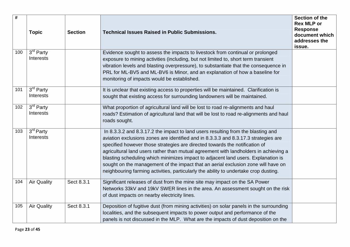
100 3rd Party Interests
Evidence sought to assess the impacts to livestock from continual or prolonged exposure to mining activities (including, but not limited to, short term transient vibration levels and blasting overpressure), to substantiate that the consequence in PRL for ML-BV5 and ML-BV6 is Minor, and an explanation of how a baseline for monitoring of impacts would be established.
101 3rd Party Interests
It is unclear that existing access to properties will be maintained. Clarification is sought that existing access for surrounding landowners will be maintained.
102 3rd Party Interests
What proportion of agricultural land will be lost to road re-alignments and haul roads? Estimation of agricultural land that will be lost to road re-alignments and haul roads sought.
103 3rd Party Interests
In 8.3.3.2 and 8.3.17.2 the impact to land users resulting from the blasting and aviation exclusions zones are identified and in 8.3.3.3 and 8.3.17.3 strategies are specified however those strategies are directed towards the notification of agricultural land users rather than mutual agreement with landholders in achieving a blasting scheduling which minimizes impact to adjacent land users. Explanation is sought on the management of the impact that an aerial exclusion zone will have on neighbouring farming activities, particularly the ability to undertake crop dusting.
104 Air Quality Sect 8.3.1 Significant releases of dust from the mine site may impact on the SA Power Networks 33kV and 19kV SWER lines in the area. An assessment sought on the risk of dust impacts on nearby electricity lines.
105 Air Quality Sect 8.3.1 Deposition of fugitive dust (from mining activities) on solar panels in the surrounding localities, and the subsequent impacts to power output and performance of the panels is not discussed in the MLP. What are the impacts of dust deposition on the
Page 24 of 45
#
Topic Section Technical Issues Raised in Public Submissions.
Section of the Rex MLP or Response document which addresses the issue.
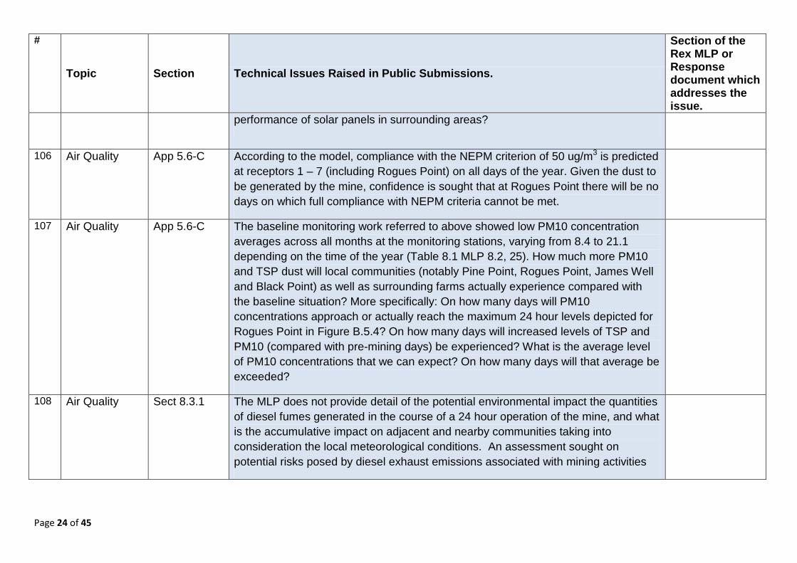
performance of solar panels in surrounding areas?
106 Air Quality App 5.6-C According to the model, compliance with the NEPM criterion of 50 ug/m3 is predicted at receptors 1 – 7 (including Rogues Point) on all days of the year. Given the dust to be generated by the mine, confidence is sought that at Rogues Point there will be no days on which full compliance with NEPM criteria cannot be met.
107 Air Quality App 5.6-C The baseline monitoring work referred to above showed low PM10 concentration averages across all months at the monitoring stations, varying from 8.4 to 21.1 depending on the time of the year (Table 8.1 MLP 8.2, 25). How much more PM10 and TSP dust will local communities (notably Pine Point, Rogues Point, James Well and Black Point) as well as surrounding farms actually experience compared with the baseline situation? More specifically: On how many days will PM10 concentrations approach or actually reach the maximum 24 hour levels depicted for Rogues Point in Figure B.5.4? On how many days will increased levels of TSP and PM10 (compared with pre-mining days) be experienced? What is the average level of PM10 concentrations that we can expect? On how many days will that average be exceeded?
108 Air Quality Sect 8.3.1 The MLP does not provide detail of the potential environmental impact the quantities of diesel fumes generated in the course of a 24 hour operation of the mine, and what is the accumulative impact on adjacent and nearby communities taking into consideration the local meteorological conditions. An assessment sought on potential risks posed by diesel exhaust emissions associated with mining activities
Page 25 of 45
#
Topic Section Technical Issues Raised in Public Submissions.
Section of the Rex MLP or Response document which addresses the issue.
109 Air Quality Sect 8.3.2 An assessment of the impacts from noise and vibration on livestock is sought, reflecting that the mine will operate 24/7 and unlike native fauna livestock are unable to relocate when faced with adverse conditions. What are the expected impacts to livestock in adjacent land, and how will this be managed?
110 Air Quality Sect 8.3.3 The mine design proposed in the MLP has been devised on the assumption that Rex will negotiate waivers in order to undertake operations on land within the blast exclusion zone but does not discuss how mining operations will be impacted if waivers are not negotiated. Clarification sought on how blasting would be managed if Rex Minerals are unable to negotiate access to all land within the blast exclusion zone? (Including management of risks to adjacent sensitive receptors and property).
111 Air Quality Solar thermal influences of the open cut mine for the displacement of diesel exhaust emissions or for any Radon gas flows through convection currents lifting and spilling diesel exhaust and Radon gas is sought. This could lead to flows across the highway and down onto Billy Goat Flat where is may be trapped for a significant period of time amongst the residential housing area.
112 Air Quality The passive solar radiation heating cool air in the pit can cause the denser than air layers of diesel exhaust emissions and Radon gas to be raised and ejected from the pit. An assessment of impacts is sought for the west wall of the mine which may receive morning solar radiation during periods when a temperature inversion can predictably form on the eastern coastline across the Billy Goat Flat residential areas.
113 Air Quality The potential impact of mining activity pollution in relation to the seasonal climate events of temperature inversion specific to the Hillside site and coastal region has not been described. Information sought on localised climatic events and associated
Page 26 of 45
#
Topic Section Technical Issues Raised in Public Submissions.
Section of the Rex MLP or Response document which addresses the issue.
influence on emissions from the mine.
114 Air Quality App 5.6-C All current air modelling focuses on PM10 and TSP. Little consideration appears to have been given to PM2.5 which may become the new industry measurement standard. An explanation for why PM2.5 was not included in the study and or modelling is sought.
115 Air Quality App 5.6-C The predicted maximum 24 hour PM10 concentration shown above reflects the dust levels expected with all dust control measures in place. Rex are placing considerable reliance on their dust suppression methods – confidence in the adequacy of these measures is sought.
Under what specific conditions will reduction or shutdown of operations occur? Who will monitor compliance with this? What criteria will be used to determine when such measures need to be implemented? And how will the waste rock piles be “shut down” given that no control measures will be in place for each one while they are in active use?
116 Air Quality Further information sought on the contamination of crops and livestock in the area from long term dust exposure from mining activities.
Detail sought on the effects of mining on agricultural activities in the region including expected effects to cropping pasture and livestock from dust including; reduced photosynthetic activity, contamination of crops and cropping products from deposition of dust directly onto physical surfaces as well as uptake and acquisition of metals into plant tissue from the soil following dust deposition on to soil, effects to livestock exposed to prolonged periods of increased dust and effects on livestock
Page 27 of 45
#
Topic Section Technical Issues Raised in Public Submissions.
Section of the Rex MLP or Response document which addresses the issue.
feeding on plants and plant materials subject to dust and plants which have potentially been affected by dust products.
117 Air Quality The dust modelling has been undertaken based on previous mine design including waste dump heights and dimensions Clarification sought on how changes in mine design have affected the modelled dust generated from mining activities.
118 Air Quality Information sought to allay concern over:
the validity of the sampling and modelling provided for this particular region, particularly in regard to the potential toxicity of copper and uranium dust emissions and their long term impact on health and the environment; and
the validity of (or as necessary, provide updated) information and modelling specific to the concentrations of copper, uranium and other potential toxic components of dust proposed to be produced on site and describe any long term effects on the region including all terrestrial and marine ecosystems, local resident health and livestock.
119 Air Quality The proposal maps that depict noise and air modelling do not reflect changes in the mine and pit design – information is sought on the impact from those changes, and why new modelling is not necessary.
120 Air Quality Modelling has determined the associated risks is based on ‘three windy days’ a year, anecdotal evidence is contrary to this with many more windy days Explanation sought for ‘three windy days per year’ in terms of long term seasonal data sets of the local weather conditions.

Page 28 of 45
#
Topic Section Technical Issues Raised in Public Submissions.
Section of the Rex MLP or Response document which addresses the issue.
121 Air Quality Currently premium malting barley is grown for local and international brewers adjacent the proposed mine site. There are concerns that dust contamination of the soils and crops will prevent our ability to continue to produce this type and yield of crop. Evidence is sought demonstrating how crops will be protected from particulate and soil contamination due to the proposed mine site.
122 Air Quality Concerns regarding rainwater supplies and health given the constant exposure to elevated dust levels. Provide evidence as above.
123 Closure The Federal Governments best practice guide ‘Landform Design for Rehabilitation’ in the South-Eastern states of Australia, any slope over about 8 degrees is unsuited to cropping given the risk of soil erosion if it is regularly cultivated. From Rex’s proposal, the slopes on the rehabilitated waste rock stacks will range from 10 to 20 degrees which would appear unsuitable for cropping. Further explanation sought on proposed post-rehabilitation outcomes.
124 Closure How does the proposed rehabilitation soil profile (500mm subsoil & 300mm topsoil) compare to the current soil profile on site.
125 Closure The assertion that arable land can be reclaimed from the stockpile and tailings area is questioned. The overburden stockpiles are mostly granite and gabbro which are igneous rocks and not soils that will support future farming. Does the description of the post-mine land use as ‘arable’ mean that it will be suitable only for grazing?
126 Closure The proposal to cover much of the site with the original topsoil is questioned. Further explanation sought on whether there will be sufficient topsoil available; the risk of topsoil degradation (loss of productive capacity) during the period prior to rehabilitation; and how much of the mine site will be returned to cropping land which
Page 29 of 45
#
Topic Section Technical Issues Raised in Public Submissions.
Section of the Rex MLP or Response document which addresses the issue.
was the primary agricultural pursuit across the site prior to mining?
127 Closure Rehabilitation includes leaving the TSF and waste rock dumps in place returning the top soil and planting grasses – questions raised about the level of investigation that has been undertaken regarding risks and benefits of backfilling the site and encapsulating any toxic waste rock in a way that will not affect the site into the future, as well as return the site to viable farming land and not leaving the site open and exposed.
128 Copper
Contamination
Sect 6.6.5.2 & 8.4.10.4
The MLP indicates that leak detection for the pipeline will occur via comparison of the flow rates, pressures, and densities at the start and end of the pipeline and indicates that in the event of a change in process flow conditions an inspection team will be dispatched to investigate the suspected area. Explanations sought regarding whether flow process conditions are able to indicate a small failure, and if not, whether visual inspection will be able to identify a small failure given the depth which the pipe is buried and length of the pipeline; How small failures which do not provide any surface indication could be identified and managed along the 11km stretch of pipeline (including during rainfall events when surface may be saturated)
129 Copper Contamination
Sect 8.3.9 Marine Environment
Although copper is an essential element for both plants and animals, it is only required in small amounts and is toxic in higher concentrations. Copper is readily bio-accumulated in plants and animals (ANZECC 2000). Assurance is sought that the following the potential toxicological impacts of mine generated dust, and mine contaminated waters will be avoided:
• Damage to the physiology of fishes (including the gills, and olfactory sense); • Mortalities among marine invertebrates, fishes and algae, particularly if
Page 30 of 45
#
Topic Section Technical Issues Raised in Public Submissions.
Section of the Rex MLP or Response document which addresses the issue.
exposed to copper; • Potential reduction in biodiversity in coastal marine sites; • Reduction in seagrass cover; • Sedimentation; or • Concentration of metals in filter-feeding organisms.
130 Copper Contamination
8.10.4.2 In 8.4.10.2 under subheading ‘Surface water contamination from chemical…’ explanation is sought on why potential surface water contamination from copper concentrate dust has not been identified as an impact given the close proximity to the marine environment, and whether this is based on an assumption that dust will be managed in its entirety? Discussion sought on the potential impact (including cumulative) of surface water contamination including pathways to the receptor (marine environment, surface vegetation and groundwater) and consequences in the event dust is not adequately managed. An explanation sought on the residual risk post implementation of any control strategies proposed.
131 Editorial Sect 6.7 Waste
Table 6.7-1 - the total footprint of the three areas listed in Table area adds up to 1435 hectares rather than 1200 hectares – clarification sought on the total area of waste rock dumps.
132 Editorial Sect 5.3.1 Justification is sought re Page 5-22 5.3.1 Residential Dwellings - states two dwellings on Redding land (quarter of Rex land) are unoccupied, these are occupied but not considered as sensitive receptors.
133 Editorial Concerns raised that many of the technical reports in the MLP documentation were based on a project design that has significantly changed, and significant issues raised by CCG and community with the proponent not adequately answered and or
Page 31 of 45
#
Topic Section Technical Issues Raised in Public Submissions.
Section of the Rex MLP or Response document which addresses the issue.
considered. Provide clarification on difference in mine design and implications this may have on relevant technical reports.
134 Emissions Sect 6.10.2 Energy Sources
The greenhouse impact of electricity use is larger than the component that must be acknowledged under NGER Reporting. It is apparent from the greenhouse gas emissions associated with electricity use that Rex Minerals has used only the scope 2 emissions factor. It is suggested that Rex Minerals should use both the scope 2 and 3 components of emissions associated with electricity use (as per the 2012 NGA Emission Factors) in defining the greenhouse impact of the project, and clarification sought on the greenhouse reduction commitment that Rex Minerals will make in relation to its electricity use.
135 Fauna Section 8.3.13
Fauna interactions – further explanation sought regarding the potential for birds to be attracted to and then impacted by the liquid tailings storage facility, and monitoring contingency plans. Clarification sought on appropriate control measures for managing the risk of fauna injuries and deaths caused by the TSF, as the primary control measures listed in Table 8.3-52 for fauna interactions are suggested as inappropriate for this impact event.
136 Geochemistry “the waste rock from the Hillside project exhibits very limited potential to generate acid” ( MLP, 6-99), the report by the consultants, Mining Plus, warns that “Given the large volume of waste rock associated with the project, further sampling may be required”, the only indication that further sampling was undertaken is a reference in the MLP (p 5.8.3 5 - 62) that a “second round of sampling was undertaken where 125 samples were analysed to further evaluate the uncertain classifications from Phase 1. Reports sought from the phase 2 sampling which evaluates the uncertain classifications from Phase I of the waste rock acid generation testing.
Page 32 of 45
#
Topic Section Technical Issues Raised in Public Submissions.
Section of the Rex MLP or Response document which addresses the issue.
137 Geology Further information and clarification sought regarding the fibrous characteristics of the ore body and waste rock and risks associated with its release and potential exposure to receptors.
138 Geology The MLP indicates that karst geological formation exists in the area however local ephemeral springs, sinkholes and doline have been recorded and utilised by local landholders and there is recorded history of large cavernous appearances along the edge of the adjoining highway, which is within the Hillside boundary. Clarification sought on potential presence or absence of Karst and related formations in regard to other identified local features and an assessment of the potential for impact by the proposal.
139 Geology East/west cross-section graph or diagram identifying the hydrogeology through the MLP and MP area that included the coastal region is sought so that any vertical recharge characteristics might be identified.
140 Geology Consideration sought regarding issues pertaining to slope stability in the event of a substantial depth of Permian or other unconsolidated sediments being present in the pit area – including design consideration for the open pit to manage this issue.
141 Light An assessment sought on the potential impacts of light spill on livestock is required.
142 Marine Evidence sought for conclusions in the MLP impact assessment (ML-A7, ML-SW1,2,3,4) stating marine and coastal dust impacts are of minor consequence. Section 5.11.1 of the MLP implies a possibly continuous influx of mining-related pollutants into the upper Gulf St. Vincent marine park however existence of northward flow along the western coast of upper Gulf is confirmed in one of the few oceanographic studies that have been undertaken in the study region. Further

Page 33 of 45
#
Topic Section Technical Issues Raised in Public Submissions.
Section of the Rex MLP or Response document which addresses the issue.
explanation sought on: how the flow pattern and slow flushing (hence ability of the water body to disperse effluents) of this region has been adequately considered in the risk assessment for air quality and marine impacts; what the level of toxicology of the built up dust is expected to be; what scientific evidence is available to demonstrate that marine flora and fauna would not be impacted by dust deposition and toxicology (both short term and cumulative impacts).
143 Meteorological Explanation sought on the expected impact to wind patterns and subsequent effect on the dispersion of fugitive dust and noise carry from mining operations resulting from the development of the Ceres Wind Farm, and whether this could influence modelling predictions in relation to sensitive receptors and compliance with noise criteria and NEPM.
144 Meteorological Evidence sought to underpin claims in relation to noise, dust and odour that meteorological conditions associated with high odour potential conditions such as calm and early morning temperature inversions are not commonly experienced in the proposed ML and MPL areas.
145 Native Vegetation
Concern raised about the management during operation of impacts on the Spider Club Orchid - further information sought on how the proponent would identify areas where the species exist and make adequate and suitable provisions to ensure its long term survival.
146 Noise Commitments sought regarding the provision of noise mitigation treatments for home owners such as double glazing.
Page 34 of 45
#
Topic Section Technical Issues Raised in Public Submissions.
Section of the Rex MLP or Response document which addresses the issue.
147 Noise Explanation sought for why Map 1.2 does not take into account the noise from haul trucks traversing the north-eastern waste rock dump.
148 Noise App 6.6-A Explanation sought for why in the Operational Noise Assessment it appears noise levels stop abruptly at the coast line and then resume across St Vincent’s Gulf.
149 Noise App 6.6-A Explanation sought for why the tailings dam becomes much bigger in year 12 from year 5 in Fig 7 & 8 on pg 16 & 18 in the Operational Noise Assessment. Does the noise modeling reflect the proposed design?
150 Noise App 6.6-A Explanation sought for why there is no noise emitted from the north & east of the northeast waste rock dump and northeast of the southern waste rock dump in Map 1-2 in the Operational Noise Assessment.
151 Radiation Explanation sought for how the blending of material described at 5.8.2.1 and 8.3.19.3 will be practically undertaken to achieve sufficient dilution (<200ppm) for the milling circuit and WRDs. Further explanation sought regarding the quantum of contaminants (e.g. uranium, heavy metals, waste processing chemicals etc) within ore body and waste rock dumps, including the basis for the conclusion and the representativeness of samples in relation to the entire ore body.
152 Radiation Further detail sought on the identification and management considerations for Uranium radiation concentration are only provided on ‘averaging’ of readings. There are no specific radiation readings of individually identified sites. Drill sites and the proposed mine site are not identified. Core sampling radiation readings have only been presented from selected drill sites and from limited depth selections as preference by the proponent. Records of volume and intensity of Radon gas radiation readings have been omitted. There is no transparency in radiation records

Page 35 of 45
#
Topic Section Technical Issues Raised in Public Submissions.
Section of the Rex MLP or Response document which addresses the issue.
upon which hazard and management criteria can be determined.
153 Radiation MLP does not consider leaching of uranium (and associated radionuclides) into Gulf St Vincent. Provide an assessment of the potential sources, pathways and receptors.
154 Radiation Further explanation sought on the risks associated with the production of Radon in waste rock dumps and tailings, and the mitigation strategies to prevent risk associated with it.
155 Radiation As uranium has been found at Hillside in concentrations up to 10,100 parts per million (ppm), explanation sought for why Uranium production is not proposed, given relatively high results compared with some other current Uranium operations.
156 Radiation Explanation sought for why blending to reduce uranium concentrations is intended to achieve no more than 200 ppm U rather than the potential changed leading-practice standard of 80 ppm U?
157 Radiation Appendix 5.8-A
Explanation sought as to:
• Whether the operators in the open cut mine and in the concentrator plant will be exposed to radiation
• Could elevated levels of uranium end up in the concentrate streams which will be slurried to the port and exported?
• Could elevated levels of uranium end up in the tailings and the waste rock piles?
• How will the mine be safely managed and rehabilitation completed effectively to ensure there are no radiation hazards?
Page 36 of 45
#
Topic Section Technical Issues Raised in Public Submissions.
Section of the Rex MLP or Response document which addresses the issue.
158 Seismicity Assessment of the likelihood and potential impact of mining induced seismicity.
159 Seismicity Explanation sought regarding the potential risk of blasting activities impacting on the integrity of coastal cliffs and an increase in risk of landslips, and how this will be managed.
160 Slurry Pipe Explanation sought for rationale for buried vs above ground slurry pipe construction, and justification for not removing the pipe as rehabilitation. Specifically:
• Justification for why a pipeline carrying potentially toxic product should not be above ground so that they can be inspected regularly to ensure there are no visible leaks;
• be appropriately bunded to contain any spills; and • be fitted with leak detection systems to register catastrophic failure and
shutdown pumping systems.
161 Socio-Economic
Further discussion sought on impacts on available/current workforce for local businesses, and how the proponent will manage their workforce without having significant effect on local business, farming and local government agencies though competition for limited employee pool.
162 Socio-Economic
An independent assessment sought on the proposed mine in relation to impacts on the economy of the local YP region and the state in both the long and short term, including all aspects of the regions current economy (i.e., recreation and tourism, commercial fishing, as well as agricultural practices).
163 Socio- Clarification sought on the impact the proposed operations will have on the total area
Page 37 of 45
#
Topic Section Technical Issues Raised in Public Submissions.
Section of the Rex MLP or Response document which addresses the issue.
Economic of productive agricultural cropping land available on Yorke Peninsula, impacts on adjacent land use, and the potential reduction of economic output from the agricultural sector, and the potential/impact of additional satellite sites being established by Rex on the Yorke Peninsula.
164 Socio-Economic
Clarification sought on the impact on the tourism industry in the vicinity of the proposed mining operations, and the benefit of mining operations relative to potential losses to already established industries.
165 Socio-Economic
Values Explanation sought regarding potential decrease in property values due to the proximity of the mine and long-term price inertia on its completion; and regarding potential for competition for rental and purchase of properties leading to a decrease in the affordability of properties in the area due to competition for property sales or rentals.
166 Socio-Economic
Further discussion is sought regarding the consultation process undertaken by Rex Minerals, including the validity and effectiveness of the CCG, information distribution, and the validity of the Community Perceptions Survey have also been raised.
167 Soil Sect 8.3.5 Further explanation sought regarding the longer-term impacts of the saline water use across the various suppression and disposal activities on site, including a total site estimate of the salt released should be provided.
168 TSF Explanation sought regarding the contents of the tailings dam and in what concentrations i.e. Heavy metals, uranium, waste processing chemicals etc).
169 TSF Explanation sought for why double poly liners were not used but rather a clay lined tailings system.
Page 38 of 45
#
Topic Section Technical Issues Raised in Public Submissions.
Section of the Rex MLP or Response document which addresses the issue.
170 Water The interrelationship of surface and groundwater flows has not been included. Explanation sought for the exclusion of interrelationship.
171 Water Section 6.6.4 Further explanation sought on exactly how and where surplus water will be re-injected, what potential impacts it might have, and how re-injection will be achieved and effectively managed
172 Water Further explanation sought regarding the basis for the ‘relatively slow’ pit refill rates including the modelled pit volume, whether the recharge rates are diminished after the initial years, and a post-mining operations water balance that shows the key flow assumptions.
173 Water The open pit appears to be approximately 1 km from the sea. The groundwater in the pit zone currently is highly saline and the groundwater elevation level is not dis-similar to mean sea level. None of the cross sectional diagrams of the pit show this proximity. The document does make reference to ‘self healing’ conditions due to clays etc, but does not indicate how quickly ‘self healing’ may take place following any geological events, including any minor seismic activity potentially triggered by digging the pit and removing groundwater.
174 Water Section 8.3.13
Further detail sought on potential impacts on adjacent farming due to reinjection, groundwater mounding under the TSF, or TSF leakage.
175 Water Potential impact event ML-GW5 discussed reduced groundwater quantity for native vegetation as a result of mine de-watering - impact description of associated risk assessment and management of reduced quantity of groundwater available for adjacent land users is sought, including what strategies will be implemented to
Page 39 of 45
#
Topic Section Technical Issues Raised in Public Submissions.
Section of the Rex MLP or Response document which addresses the issue.
prevent impact to surrounding groundwater users.
176 Water Potential impact event ML-GW2 describes groundwater contamination from AMD and leakage from water storages - description sought of the potential for leaching of contaminants (heavy metals) contained within the ore body and subsequent groundwater contamination, and what strategies will be adopted to reduce contamination of groundwater from heavy metals.
177 Water Groundwater modelling based on drill depths to 200m however underground mining planned to 700m; hydrogeological considerations of geological faults and fractures generating restriction of groundwater transmissivity flows cannot be equated and therein supports modelling extrapolations to an additional 500m. Explanation sought on why drill depths for modelling have not extended to 700m to inform risk assessment for underground mining operations.
178 Water Test pumping for groundwater volume that was undertaken was during the direst months of the year when the unconfined aquifer would predictably be dry/not saturated. Explanation sought on the appropriateness of timing of the pump testing.
179 Water Justification sought for the use of airlift techniques for test pumping to define groundwater volumes given concerns over accuracy of this method.
180 Water Records of rates of recharge and standing water level are absent as data sets for the cone of depression.
181 Water Additional surface water modelling sought which includes current mine design and proximity to local drainage lines and runoff paths.
Page 40 of 45
#
Topic Section Technical Issues Raised in Public Submissions.
Section of the Rex MLP or Response document which addresses the issue.
182 Water Confidence sought that following mine completion and pit flooding, there will be no leakage of pit water into the aquifers, and ultimately into the Gulf waters, over the next 500 plus years.
183 Water Explanation sought for not placing and encapsulating contaminated tailings and rock into the pit and backfilling.
184 Water Clarification sought on the level of contamination in the pit water post closure, and what will be the consequences if it leaches into the Gulf and or surrounding shallow groundwater.
185 Water Explanation sought regarding assumptions and risk relating to potential for the ‘seasonal perched Quaternary aquifer’ to be impacted by mining, given this was not targeted by drilling, and could be a water source for stock etc.
186 Water Clarification sought on apparent focus of Wells for test pumping targeting only the deeper aquifer (represented by groundwater model Layer 3) and only on attaining estimates of likely inflow to the pit wall.
187 Water The sole long-term pump test (conducted at well WBTH005, reported in Appendix A 9.7) is neither reported nor included in the tabulation in Section 4 of the body of the DFS report. The test indicates an acceleration of drawdown with time. Further discussion sought on the implications of this test, other than that it was conducted to gain an appreciation of the pumping effects on the fractured aquifer zone.
188 Water Hydraulic parameters from test pumping were used to inform the Groundwater (GW) model. Recharge and groundwater levels were not used as inputs. Clarification sought.
Page 41 of 45
#
Topic Section Technical Issues Raised in Public Submissions.
Section of the Rex MLP or Response document which addresses the issue.
189 Water Justification sought for validity of model given lack of baseline data including groundwater hydrographs (i.e. groundwater level fluctuations with time) available to calibrate the model, and why baseline data over a minimum of one complete year and preferably years that included drought-dominated regime and a wetter year was not obtained.
190 Water Justification sought for limited duration of test pumping activities.
191 Water Clarification sought on whether wells were installed in all hydrogeological zones (per the PFS), given no details of wells targeting the ‘seasonal perched Quaternary aquifer’.
192 Water Justification sought for modelling assumptions and further explanation of the implications of the model for the environment:
The permeability of Layer 4 has not been defined by field investigations; it is an assumed value. It appears to be a product of the lack of deep drilling.
It is noted that the outputs from the model indicate that Layer 4 is sensitive to changes in permeability and storativity (standard groundwater hydraulic parameters).
The calibration of the model is questionable as it appears to rely on five bores only; two in the Coastal Granite and three in the pit area. The model has embraced a zone of potentially fractured granites to the north and east of the proposed mine in a zone that appears to have an enhanced permeability.
A number of hypothetical cut-off wells have been modelled as intercepting
Page 42 of 45
#
Topic Section Technical Issues Raised in Public Submissions.
Section of the Rex MLP or Response document which addresses the issue.
groundwater flows that appear to exploit this zone of higher permeability. These cutoff wells are oriented north north-east of the proposed pit area to intercept 150L/s (essentially the mine processing water use requirement). Their role appears to be to intercept any potentially contaminated underground water migrating beyond the mining lease.
Theoretically, under the modelling scenario adopted, all underground water leaving the mine site through this zone can be intercepted except in the final two years of mine operation, wherein there is an 11% excess volume. Accordingly, in the final two years of operations, there is a threat of contaminated underground waters leaving the site that has not been addressed.
193 Water Explanation sought regarding post-closure outcomes: the dewatering cone of drawdown does not fully recover to pre-mining groundwater levels. Essentially, the pit (lake) becomes a permanent groundwater sink. Whilst this may, in the short to medium term, assist in restricting off-site migration of any contaminated underground water, there is nonetheless a stated effect for 550 years (the duration of the post-mining model). Whether this impacts on the ‘seasonal perched Quaternary aquifer’ or any other perched groundwater system remains unknown. If any connections exist, this would have implications for any stock bores in the zone of influence.
194 Water Comments sought on the following suggested groundwater reporting limitations
Whilst technically sound, the reporting of the test pumping and groundwater modelling is lacking appropriate context. It neither transparently explains the assumptions of the hydrogeological conceptualisation nor does it discuss results in

Page 43 of 45
#
Topic Section Technical Issues Raised in Public Submissions.
Section of the Rex MLP or Response document which addresses the issue.
terms of the wider environmental implications
The report neglects to address any surface water and groundwater interactions.
The report neglects to address any near surface waters.
Inter alia, the report does not address potential impacts to any groundwater dependent ecosystems in the zone of influence.
It is noted that the Coastal Granites are highly fractured and productive aquifers (up to 10 L/s) and GW discharge quality, as a result of mining, may have potential to exceed the ANZECC water quality guidelines for ecosystems.
Only the middle two layers of the GWM are verified by field investigations.
The deeper 4th layer assumes the rocks are tighter at depth therefore less permeable. This may not necessarily be the case as deep fractures may occur in fault zones in the Yorke Peninsula.
The ‘seasonal perched Quaternary aquifer’ has not been the subject of any field investigations. We recommend that, at a minimum, existing geotechnical logs from drill-holes and/or excavated test pits should be examined and pertinent data extracted (e.g. permeability values) to inform the groundwater modelling (Layer 1).
Operationally, it is unclear whether the mine is to have a dedicated water supply wellfield (to be drilled east of the proposed pit location of Wells 23-27 – Coastal Granites). This again requires clarification.
The cone of drawdown will be steep; however there may be linear extensions of less steep but more extensive drawdown along lines of enhanced permeability due to
Page 44 of 45
#
Topic Section Technical Issues Raised in Public Submissions.
Section of the Rex MLP or Response document which addresses the issue.
fracturing sympathetic with the regional geological faulting. No discussion of this is offered.
The water quality in the ore body versus the granite GW systems may be different. If so, a discussion is required as to how the disposal of the dewatered water and interaction between these different quality waters would be managed.
195 Water The reporting results in an apparent disconnect between the high yields intercepted during mineral RC drilling and dedicated water well drilling. This may be because fractures are essentially vertical and therefore wells drilled at the vertical may fail to intercept the more permeable fracture zones (as opposed to mineral holes drilled at angles that may intercept a number of sets of the fracture by their orientation). This leads to some confusion in the conceptualisation of the hydrogeology in that testing is indicating relatively impermeable conditions whilst the mineral drilling suggests that the geological zones can be highly permeability. Further clarification is sought. .
196 Water Issues specific to the Mining Plus DFS Report, dated 9 May 2013:
The well completion summary Table 1 and Figure 1 appear to be a subset of the complete program of wells drilled. No clear reason is given for not including all wells.
The drilling and test-pumping program is aligned to the pit rock mass, hanging wall and footwall zones only. Reasons are not given for the omission of other geological zones.
Discussion the results of the test pumping program is perfunctory. The DFS report states that all wells with airlift yield more than 1L/s were tested, but in the prefeasibility report there were more wells stated that fit this definition. If results were

Page 45 of 45
#
Topic Section Technical Issues Raised in Public Submissions.
Section of the Rex MLP or Response document which addresses the issue.
selectively reported, a reason for this is not given.