appendix 1.1 – the three tribes and their ancestral domains · pdf fileappendix 1.1...
TRANSCRIPT

APPENDIX 1.1 – THE THREE TRIBES AND THEIR ANCESTRAL DOMAINS The pilot survey covers three pre-selected indigenous peoples and their ancestral domains, i.e., Bago Tribe in Sugpon, Ilocos Sur; Kankanaey Tribe in Kibungan, Benguet; and the Bugkalot Tribe, found in scattered villages mainly in Nueva Vizcaya, Quirino and Aurora provinces in the northern part of Luzon Island in the Philippines.
A.1 The Bago Tribe The Bago tribal group is a product of intermarriage between the Ilocanos of the lowlands and different indigenous cultural communities of the Cordillera. They settled between the mountain ranges of Ilocos and the boarders of the Ilocos Provinces, La Union, and Pangasinan. They are of medium build, although some resemble the Kankanaeys with fair complexion and a sturdy build. Of Iloco-Cordillera descent, the Bago practice simple, ordinary methods of agriculture. Tobacco-drying barns are frequently found, together with harvests of garlic and onion. Their farming methods and practices include a system of initiating farm workers at harvest time through a working relationship known as gamal, ammuy, and bunggoy. Prominent members of the Bago indigenous group are former Governor Lupo Biteg of Ilocos Sur and his son Jonathan Biteg, who also became the Municipal Mayor of the same town. Today, Bago Maors have a league of their own, known as Ilocos Sur Upland Towns Association, which serves as a forum in which higher political authorities can hear their aspirations for development.
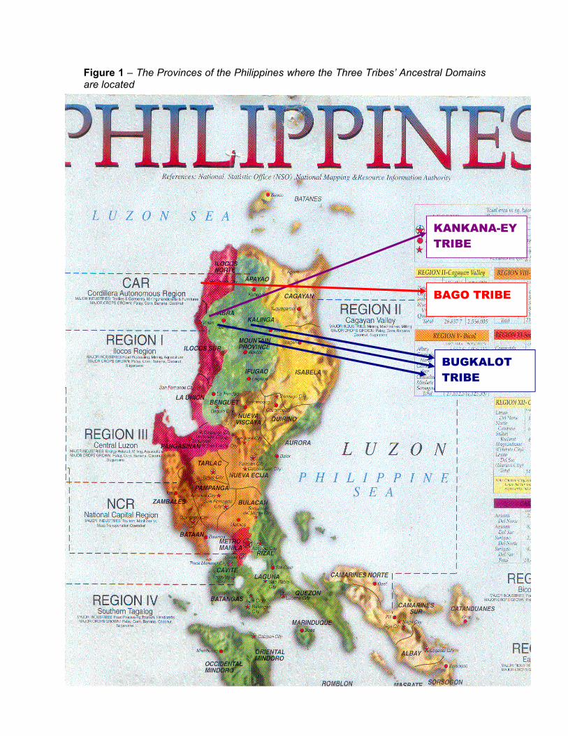
Figure 1 – The Provinces of the Philippines where the Three Tribes’ Ancestral Domains are located
KANKANA-EY TRIBE
BAGO TRIBE
BUGKALOT TRIBE
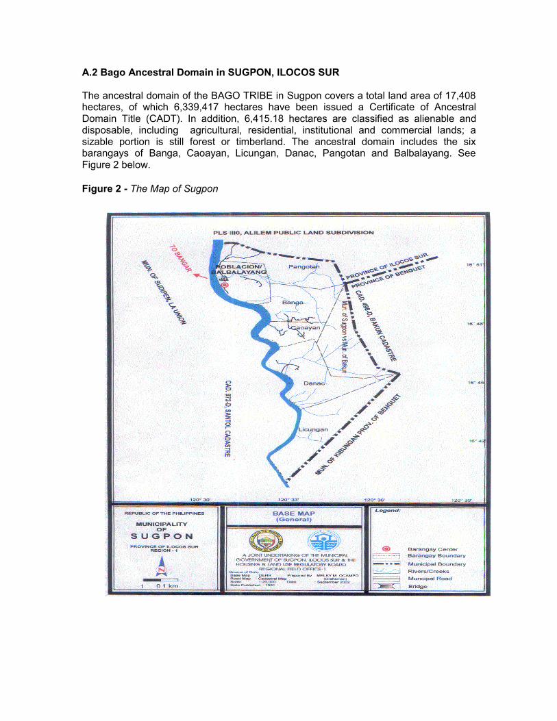
A.2 Bago Ancestral Domain in SUGPON, ILOCOS SUR The ancestral domain of the BAGO TRIBE in Sugpon covers a total land area of 17,408 hectares, of which 6,339,417 hectares have been issued a Certificate of Ancestral Domain Title (CADT). In addition, 6,415.18 hectares are classified as alienable and disposable, including agricultural, residential, institutional and commercial lands; a sizable portion is still forest or timberland. The ancestral domain includes the six barangays of Banga, Caoayan, Licungan, Danac, Pangotan and Balbalayang. See Figure 2 below. Figure 2 - The Map of Sugpon
Sugpon was originally part of the Commandancia Politico Militar de Amburayan during the Spanish Colonial period. Subsequently, all the sub-provinces of Amburayan, Lepanto and Benguet were transferred to Ilocos Sur and La Union during the American occupation. During this time, Sugpon became part of the Second Congressional District of Ilocos Sur. In 1978, long after the Philippines gained independence, it was reclassified as a sixth-class municipality. One of the 14 upland municipalities of Ilocos Sur, Sugpon is situated at the southernmost part of the province. It is bounded on the north by the town of Alilem, Ilocos Sur; on the south by Kibungan, Benguet; on the southwest by Santol, La Union; on the east by the towns of Bakun and Kibungan, Benguet; and on the west by the Amburayan River. Elevation ranges from 100 metres to 1000 metres above sea level, with slopes ranging from 0% to more than 50%. The barangay with the highest elevation and degrees of slopes are Caoayan and Licungan.
Sugpon is settled by the Kankanaey and Bago tribes. It is said that in the 18th and 19th centuries, Kankanaeys from the Mankayan and Buguias areas (now Benguet) migrated to other parts of the Cordilleras, including Sugpon. They eventually called themselves “Bago.” Many aspects of Kankanaey and lowland Ilocano cultures are practiced by the Bago People. Today, Bago are acknowledged to be a mixture of Igorot and Ilocano ancestry. Life in Sugpon is influenced by the Amburayan River. During the rainy season (May to November), the town becomes inaccessible by land, because of flooding. Within the town itself during this time, five of its six barangay are isolated due to floodwaters. However, the town benefits from the river as a source of fish and other river products. Residents also pan for gold. Largely agricultural in character, Sugpon’s croplands account for 666 hectares of A and D lands. The total population of Sugpon as of the last census is 3,466. Of this population, 1,249 persons reside in the poblacion/Balbalayang area, classified as urban. Pangotan, which is about 3.5 km from the centre of town (or approximately an hour’s hike), is the least inhabited barangay, with 246 persons. Sugpon’s population time-line shows peaks of population growth and troughs of decline since 1903. It grew slightly from 3,381 persons to 3,466 from 1995 to 2000. Sugpon is an agricultural community and the people are mostly farm owner/cultivators who grow rice, camote, gabi, legumes, coffee, and tobacco. Household members are engaged in raising hogs, goats, poultry and cattle in the small plots. The following table shows the population distribution of Sugpon as of 2000. Table 1 - Sugpon’s Population per Barangay, 2000.
Barangay Population Balbalayang (Pob.) 1,245 Banga 665 Caoayan 654 Danac 368 Licungan (Cullang) 335 Pangotan 246
TOTAL 3,513
B.1. The Bugkalot Tribe The Bugkalots are found in the provinces of Nueva Ecija, Nueva Vizcaya, Quirino and Aurora, occupying no less than 62 widely scattered village-communities. They inhabit the eastern central part of the Caraballo and Sierra Madre Mountain ranges. The Bugkalots subsist on the kaingin system of agriculture, with root crops as their main produce. Their primary occupation is hunting wild game in the forest near the Conwap River. At the head stream of the Casecnan river is another group, known as the Italon tribe, whose members are of regular build and have Mongolian features, such as narrow, slanting eyes and an aquiline nose. The same characteristics are observed among other groups known as Abacas/Tamsis, Dakgans, and Kadayakans. The Kadayakans are found in Ditale, Dipaculo and Bayanihan, Baler, Aurora (now Quezon). The Kadayakans speak fluent Tagalog in addition to their own dialect because of the influence of the Tagalogs who inhabit the Aurora Province. The Bugkalots are found along the rivers of Bua and Tubo and in some parts of Conwap speak llokano. This group is found in Kasibu, Nueva Vizcaya. No less than 5,000 Bugkalot head families reside in the aforementioned provinces. Although they live far apart from one another, their linguistic similarities, customs and arts show that they belong to one distinct group. They are known for their colourful attire, musical instruments, and artefacts This study considers the Bugkalot tribes of Nueva Vizcaya, Quirino and Aurora provinces. B.2 Bugkalot Ancestral Domain in NUEVA VIZCAYA, QUIRINO and AUROR B.2.1 Nueva Vizcaya Nueva Vizcaya lies within the heart of northern Luzon. It is one of the five provinces of Region II and one of the four provinces of Cagayan Valley. It is located at the southernmost part of the region and is often referred to as the gateway to Cagayan Valley. Nueva Vizcaya sits at the juncture of the towering heights of the Cordillera and Caraballo mountain ranges in northern Luzon. It both isolates and connects two broad expanses of flat plains. The province is bounded by Ifugao on the north, Isabela on the northeast, and Quirino to the east. Aurora lies to the southeast, Nueva Ecija to the south, and Pangasinan to the southwest. It shares a long common border with Benguet in the west. The Caraballo mountain range, which runs transversely between the southern part of the Cordillera range and the Sierra Madre range on the eastern seaboard, dominates the province. The land is generally mountainous and rugged, cut by hills and valleys. The climate varies from tropical to semi-temperate, with rain distributed through most of the year and punctuated by a very short dry season. The province also consists of one congressional district with two sectors, north and south. The subdivision follows the administrative jurisdiction set in the Sangguniang Panlalawigan.
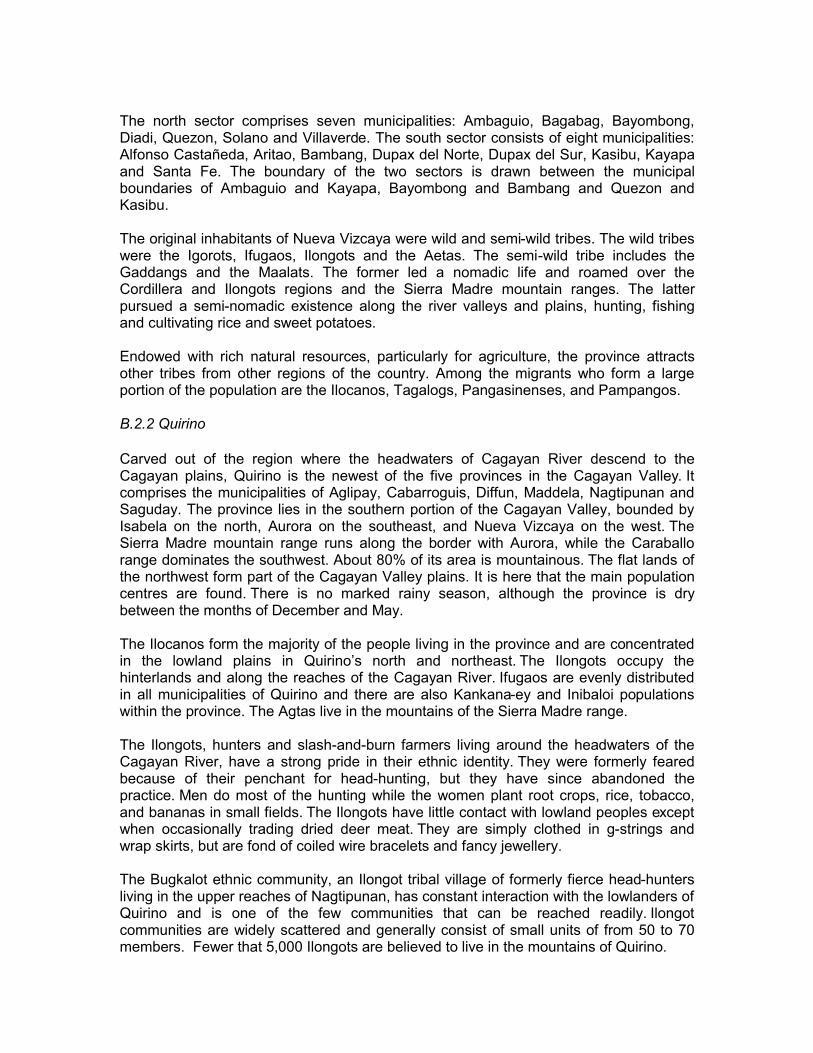
The north sector comprises seven municipalities: Ambaguio, Bagabag, Bayombong, Diadi, Quezon, Solano and Villaverde. The south sector consists of eight municipalities: Alfonso Castañeda, Aritao, Bambang, Dupax del Norte, Dupax del Sur, Kasibu, Kayapa and Santa Fe. The boundary of the two sectors is drawn between the municipal boundaries of Ambaguio and Kayapa, Bayombong and Bambang and Quezon and Kasibu. The original inhabitants of Nueva Vizcaya were wild and semi-wild tribes. The wild tribes were the Igorots, Ifugaos, Ilongots and the Aetas. The semi-wild tribe includes the Gaddangs and the Maalats. The former led a nomadic life and roamed over the Cordillera and Ilongots regions and the Sierra Madre mountain ranges. The latter pursued a semi-nomadic existence along the river valleys and plains, hunting, fishing and cultivating rice and sweet potatoes. Endowed with rich natural resources, particularly for agriculture, the province attracts other tribes from other regions of the country. Among the migrants who form a large portion of the population are the Ilocanos, Tagalogs, Pangasinenses, and Pampangos. B.2.2 Quirino Carved out of the region where the headwaters of Cagayan River descend to the Cagayan plains, Quirino is the newest of the five provinces in the Cagayan Valley. It comprises the municipalities of Aglipay, Cabarroguis, Diffun, Maddela, Nagtipunan and Saguday. The province lies in the southern portion of the Cagayan Valley, bounded by Isabela on the north, Aurora on the southeast, and Nueva Vizcaya on the west. The Sierra Madre mountain range runs along the border with Aurora, while the Caraballo range dominates the southwest. About 80% of its area is mountainous. The flat lands of the northwest form part of the Cagayan Valley plains. It is here that the main population centres are found. There is no marked rainy season, although the province is dry between the months of December and May. The Ilocanos form the majority of the people living in the province and are concentrated in the lowland plains in Quirino’s north and northeast. The Ilongots occupy the hinterlands and along the reaches of the Cagayan River. Ifugaos are evenly distributed in all municipalities of Quirino and there are also Kankana-ey and Inibaloi populations within the province. The Agtas live in the mountains of the Sierra Madre range. The Ilongots, hunters and slash-and-burn farmers living around the headwaters of the Cagayan River, have a strong pride in their ethnic identity. They were formerly feared because of their penchant for head-hunting, but they have since abandoned the practice. Men do most of the hunting while the women plant root crops, rice, tobacco, and bananas in small fields. The Ilongots have little contact with lowland peoples except when occasionally trading dried deer meat. They are simply clothed in g-strings and wrap skirts, but are fond of coiled wire bracelets and fancy jewellery. The Bugkalot ethnic community, an Ilongot tribal village of formerly fierce head-hunters living in the upper reaches of Nagtipunan, has constant interaction with the lowlanders of Quirino and is one of the few communities that can be reached readily. Ilongot communities are widely scattered and generally consist of small units of from 50 to 70 members. Fewer that 5,000 Ilongots are believed to live in the mountains of Quirino.
B.2.3 Aurora Aurora lies on the mid-eastern coast of Luzon. It is bounded by Isabela province to the north, Quirino, Nueva Viscaya to the northwest, and Quezon in the south. What is now Aurora province was formerly the two municipalities of Baler and Casiguran, then a part of Quezon (formerly Tayabas), founded in 1856 by the Spaniards, then called District of El Principe, Nueva Ecija. Today, the municipalities of Aurora include Baler, Casiguran, Dilasag, Dinalungan, Dingalan, Dipaculao, Ma. Aurora and San Luis. Aurora is about four hours from Nueva Ecija but it is remarkably different in pace and atmosphere from its western neighbour. Life in Aurora is unhurried and simple. There are no movie houses in the capital, nor is there a market or wharf. What Aurora offers is a quiet, uncomplicated rural charm that blends very well with the greatness of its history and natural beauty. As a province separated from the rest of Luzon by the Sierra Madre mountain range, Aurora's strategy for development is to capitalise on its largely untapped natural resources through the introduction of value-added industries. More than seventy percent of the land area is still forested, while the remaining land is mostly dedicated to agriculture. The main products are copra, banana, root crops, coffee, black pepper and citrus. Aside from prime wood species, such as narra, dau and tanguile, the province's forests are a rich source of sabutan, nipa, buri, pandan, bamboo, rattan, cogon and vines. Aurora’s population of 142,000 provides manpower for the province's agriculture, fishery, and forestry-based industries. The people in the province of Aurora are generally friendly and hospitable. Most of the inhabitants are migrants from nearby provinces. Tagalog and Ilocano are the dialects commonly used. The Dumagats and Ilongots are its indigenous peoples.
C.1 The Kankanaey Tribe The Kankanaeys speak Kalkali, a dialect similar to the Bontocs and akin to the lloko, and number about 125,000 (National Council of Churches of the Philippines, 1988). They are found in Bakun, north central Benguet (Mankayan, Buguais, Kapangan, and Kibungan), and western Bontoc (Bauko, Besao, Sagada, Tadian). Agricultural lands are the tribes’ main source of sustenance and the chief form of wealth. The Kankanaeys have settled and remained in this region principally because of its agricultural potential. They constructed rice terraces, which have become sufficient sources of food. Springs and waterfalls are the chief source of water for irrigating their terraces. They practice the kaingin system. They harvest their crops twice a year. The Kankanaeys also hunt and fish. Hunting is done with spears and dogs, and with the use of a deep pit or bito, which is covered by a trap. Fishing is done with the use of bamboo fish trap, such as the obeor omat, for catching small fish, and the uda, an elongated fish trap to catch eel (dalif), a delicacy when cooked. Women engage in blackloom weaving and produce native blankets, tapis, and baskets. The men engage in bamboo basket-weaving, woodcraft, pottery, and furniture-making. C.2 The Kankanaey Ancestral Domain in KIBUNGAN, BENGUET Kibungan is one of the original 31 rancherias of the Distuto de Benguet during the Spanish period. These rancherias were eventually made into towns during the American regime, each headed by a president. It is now one of the 13 municipalities of Benguet province. It is an old settlement, said to have been founded by Malays who eventually built the original stone wall rice terraces about 1,000 years ago. It is said that traders from China and Indonesia frequented the area because of its mineral resources. The people’s customs and traditions reflect the dominant Kankanaey culture. The area is bounded on the north by Bakun and Mankayan municipalities, on the south by the towns of Atok and Kapangan, on the west by the provinces of Ilocos Sur, and on the east by the municipality of Buguias. The vegetative cover is mainly pine trees, grasses, shrubs and cogon. The municipality grows a variety of upland vegetables, such as cabbage, potatoes and carrots in addition to the ubiquitous sayote. Vegetable farming has become a good source of income, hence forests have given way to vegetables, particularly on those lands owned privately. Known as the “Sayote Capital of Benguet,” Kibungan is only 67 kilometres from Baguio City, but travel time is four hours on a good day. The only access to the poblacion is through the Acop-Kapangan-Kibungan national road; but if one is bound for the barangays of Madaymen and Palina, the route is through the Halsema-Sinipsip-Bakun road. Poor transportation routes and facilities are considered a major obstacle to the development of the town. The main road that leads to town from Baguio or La Trinidad is unpaved and poorly maintained. During the wet season, Kibungan is practically isolated, and the movement of people, good and services suffers.
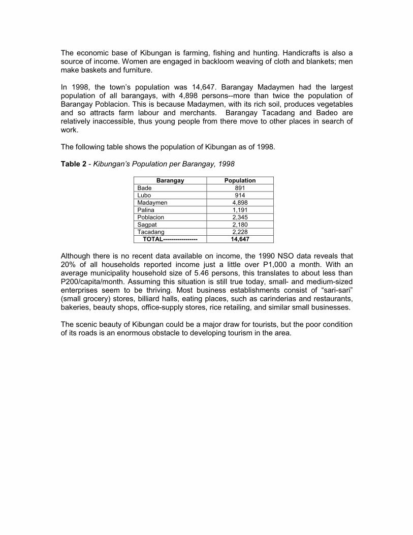
The economic base of Kibungan is farming, fishing and hunting. Handicrafts is also a source of income. Women are engaged in backloom weaving of cloth and blankets; men make baskets and furniture. In 1998, the town’s population was 14,647. Barangay Madaymen had the largest population of all barangays, with 4,898 persons--more than twice the population of Barangay Poblacion. This is because Madaymen, with its rich soil, produces vegetables and so attracts farm labour and merchants. Barangay Tacadang and Badeo are relatively inaccessible, thus young people from there move to other places in search of work. The following table shows the population of Kibungan as of 1998. Table 2 - Kibungan’s Population per Barangay, 1998
Barangay Population Bade 891 Lubo 914 Madaymen 4,898 Palina 1,191 Poblacion 2,345 Sagpat 2,180 Tacadang 2,228
TOTAL----------------- 14,647 Although there is no recent data available on income, the 1990 NSO data reveals that 20% of all households reported income just a little over P1,000 a month. With an average municipality household size of 5.46 persons, this translates to about less than P200/capita/month. Assuming this situation is still true today, small- and medium-sized enterprises seem to be thriving. Most business establishments consist of “sari-sari” (small grocery) stores, billiard halls, eating places, such as carinderias and restaurants, bakeries, beauty shops, office-supply stores, rice retailing, and similar small businesses. The scenic beauty of Kibungan could be a major draw for tourists, but the poor condition of its roads is an enormous obstacle to developing tourism in the area.