appendix 2 - hays trinity groundwater conservation district
TRANSCRIPT

Appendix 2
Cypress Creek-Structural Analysis

HAYS TRINITY GROUNDWATER CONSERVATION DISTRICT
Cypress Creek Project-Structural analysis: Characteristics of the Glen Rose formation in and around the Cypress Creek
watershed and their implications on groundwater flow
Hays County, TX
June- August 2008
Wesley Schumacher
Stephen Saller
Abstract: Located along the Balcones Escarpment in Central Texas is a rapidly growing development corridor that contains some of the fastest growing counties in the country. The primary water source in this region has historically been groundwater and recent development has resulted in increased demand on aquifer resources. Understanding the structural geology of a tectonically altered carbonate rock region can yield important information regarding flow regimes of local groundwater. In the Cypress Creek watershed of Hays County, TX, the Balcones Fault Zone has created extensive faulting and jointing patterns throughout the Glen Rose and underlying formations. These geostructural trends correspond to the principle tectonic stresses applied to the rock. Measurements of these trends are recorded and presented herein. The karstic nature of the aquifer that has developed subsequent to the jointing and faulting in the Upper and Lower Glen Rose is complex and still under study. The interpretation of groundwater flowpaths, storage, residence times and yield is reliant on the understanding of the structural nature of the aquifer. It is our hope that this report increases understanding of the aquifer and thus allows for better management of its resources.
2
Table of Contents
Figures ................................................................................................................................ 2
Introduction ................................................................................................................................3
Geologic Setting ...........................................................................................................................4
Hydrologic setting ......................................................................................................................8
Data Collection ...........................................................................................................................9
-Structural Data .................................................................................................................................................. 9
-Locating Stratigaphic Markers ...................................................................................................................... 11
-Sample Collection........................................................................................................................................... 13
-Ground Truthing .............................................................................................................................................. 13
-Field Work Summary ..................................................................................................................................... 14
Resultant Data .......................................................................................................................... 14
-Structural Mapping ......................................................................................................................................... 14
-Corbula Bed Tracing ...................................................................................................................................... 17
- Karstification ................................................................................................................................................... 18
Analysis ..................................................................................................................................... 19
Future Work Considerations................................................................................................... 20
Acknowledgements ................................................................................................................. 20
Works Cited .............................................................................................................................. 21
Appendix ................................................................................................................................... 22

3
Introduction
The geologic study of the Cypress Creek watershed is an essential stepping stone to the understanding of groundwater dynamics in Hays County and the Trinity aquifer as a whole. The Lower Cretaceous carbonate units exposed in central Texas contain aquifers which are relied upon as essential water supplies for some cities and agriculture in the region. The Trinity aquifer is the lowest Cretaceous stratigraphic aquifer in the region and one of the most understudied. Through a grant from Texas State University the Hays Trinity Groundwater Conservation District (HTGCD / the district) has begun laying the groundwork for a comprehensive geologic and hydrogeologic understanding of the aquifer. This knowledge will allow the district to plan future development and insure desired future conditions for the aquifer and the natural areas that rely on it. HTGCD geologist Alex S. Broun is overseeing the geologic inquiry of the Cypress Creek watershed. The long term goal for this project is to provide geologic data that can be used by physical hydrology modelers to help determine karstic flow regimes in order to better assess the state of groundwater used by the people of Hays County.

4
Figures
Figure 1…………………………………………………………………………………………………………………………………………………..4
Figure 2…………………………………………………………………………………………………………………………………………………..5
Figure 3…………………………………………………………………………………………………………………………………………………..5
Figure 4…………………………………………………………………………………………………………………………………………………..6
Figure 5…………………………………………………………………………………………………………………………………………………..7
Figure 6…………………………………………………………………………………………………………………………………………………..8
Figure 7…………………………………………………………………………………………………………………………………………………..9
Figure 8…………………………………………………………………………………………………………………………………………………10
Figure 9…………………………………………………………………………………………………………………………………………………11
Figure 10……………………………………………………………………………………………………………………………………………….12
Figure 11……………………………………………………………………………………………………………………………………………….13
Figure 12……………………………………………………………………………………………………………………………………………….14
Figure 13……………………………………………………………………………………………………………………………………………….15
Figure 14……………………………………………………………………………………………………………………………………………….16
Figure 15……………………………………………………………………………………………………………………………………………….17
Figure 16……………………………………………………………………………………………………………………………………………….17
Figure 17……………………………………………………………………………………………………………………………………………….18
Figure 18……………………………………………………………………………………………………………………………………………….19
5
Geologic Setting
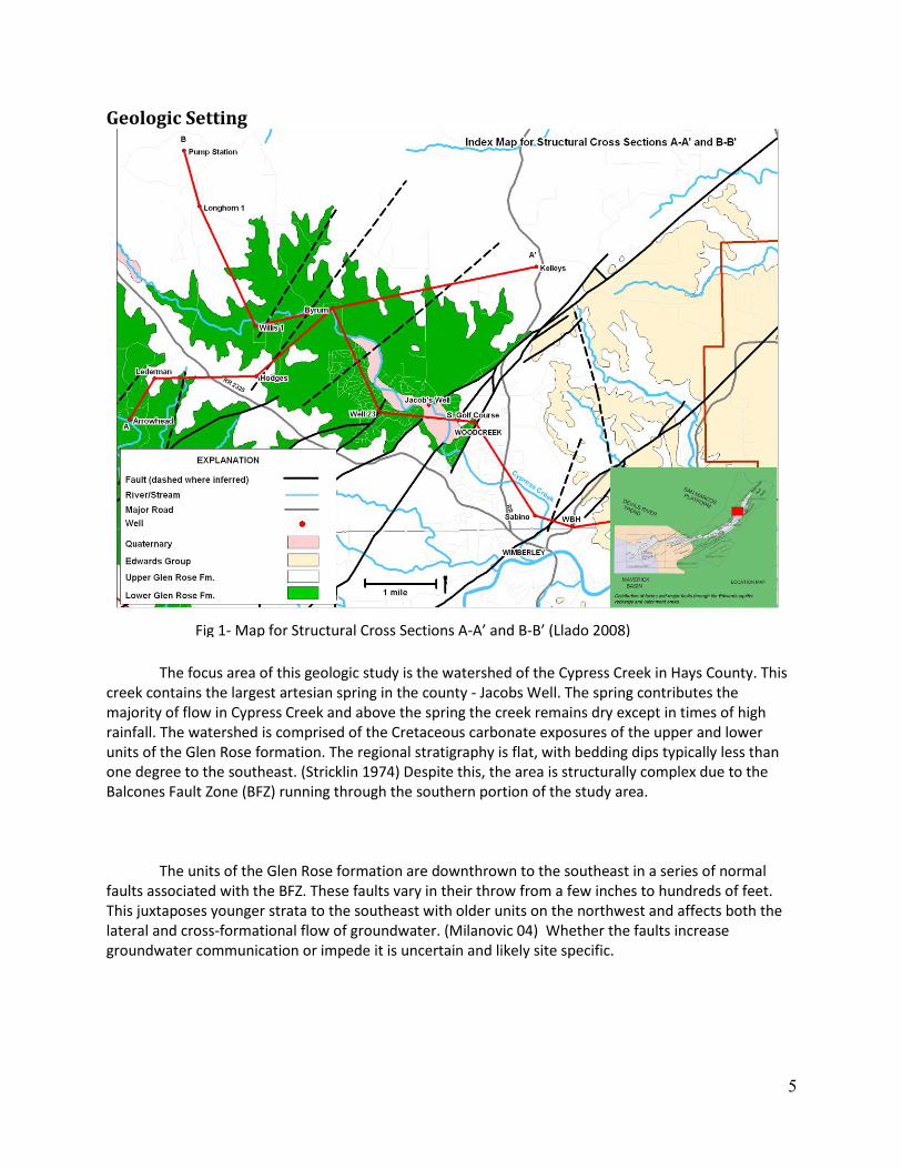
The focus area of this geologic study is the watershed of the Cypress Creek in Hays County. This creek contains the largest artesian spring in the county - Jacobs Well. The spring contributes the majority of flow in Cypress Creek and above the spring the creek remains dry except in times of high rainfall. The watershed is comprised of the Cretaceous carbonate exposures of the upper and lower units of the Glen Rose formation. The regional stratigraphy is flat, with bedding dips typically less than one degree to the southeast. (Stricklin 1974) Despite this, the area is structurally complex due to the Balcones Fault Zone (BFZ) running through the southern portion of the study area.
The units of the Glen Rose formation are downthrown to the southeast in a series of normal faults associated with the BFZ. These faults vary in their throw from a few inches to hundreds of feet. This juxtaposes younger strata to the southeast with older units on the northwest and affects both the lateral and cross-formational flow of groundwater. (Milanovic 04) Whether the faults increase groundwater communication or impede it is uncertain and likely site specific.
Fig 1- Map for Structural Cross Sections A-A’ and B-B’ (Llado 2008)

6
The Glen Rose formation is divided into the Upper Glen Rose (Kgru) and the Lower Glen Rose
(Kgrl). The boundary between the two is identified by a marker bed of calcite cemented skeletal grainstone named the Corbula bed after its identifier fossil Eoursivivas harveyi (formerly Corbula maritinae). (Ward 2007) The Corbula bed ranges in thickness from a few inches to a foot and is often rust colored to orange in color though it may appear grey and unstained. The Corbula bed often contains ripple marks indicating a subtidal depositional environment.
The upper Glen Rose averages 450ft in thickness and is composed of alternating and
interbedded shale and carbonate mudstone units. This alternating stratigraphy results in a distinctive “stair step” topography in outcrop. Structurally the upper Glen Rose behaves like a moderately competent rock. Fracturing can be observed in the resistant limestone units, however the shale and marly units tend to absorb and stall fracturing. (Ferrill 2008)
The lower Glen Rose is a more competent unit composed of two major “Rudistid reefs” and
The lower Glen Rose is a more competent unit composed of two major “Rudistid reefs” and
multiple other thinner beds of limestone with minor shale beds dispersed near the top of the section. (Stricklin 1974) The stratigraphy of the lower Glen Rose is much more massive in nature and averages 250ft in thickness. The greater competence of these more massive units results in more abundant and
Fig 3- A) Example of Kgru in roadcut. B) Alternating shale and limestone units in upper Glen Rose showing fault and joint stalling in shales. Red lines indicate fault surface. Blue indicates joints.
A B
Fig 2- Cross section A-A’ showing the downfaulting of Cretaceous rocks in the Balcones fault zone (Broun 2008)

7
more visible fracturing. Also the greater structural competence results in greater continuity of joints and fault scarps. Unlike the shale rich upper Glen Rose the lower Glen Rose allows faults and joints to transect much of its thickness without stalling or sealing the fractures. (Ferrill 2008)
A B
C
Fig 4- A) and B), examples of the Lower Glen Rose (Kgrl) outcropping on the Lin Lila Ranch. B) Blue lines indicate joint surfaces. C) Fault scarp with notebook for scale.

8
Fig 5- Stratigraphic Column (Broun 05)

9
Hydrologic setting The Cypress Creek watershed overlies the recharge zone of the upper and middle zones of the
Trinity aquifer. The upper zone of the Trinity aquifer is located stratigraphically in the upper Glen Rose. Due to its alternating layered stratigraphy of shales and carbonates, the upper Glen Rose is prone to contain numerous perched water tables rather than saturating through its thickness from the bottom up as a porous media unconfined aquifer would. The preferential fracturing in the more competent beds juxtaposed with the fracture stalling and sealing shales produces alternating zones of free water flow and aquitards. This results in numerous seeps and conduit springs throughout the area of Kgru exposure. These shallow perched water tables served as the first groundwater sources for settlers during early colonization by Europeans. However, as development has increased in the region and populations have become denser, these small volume aquifers have been depleted and few remain flowing during droughts.
The lower Glen Rose forms the upper portion of the middle Trinity aquifer. The water table is
The lower Glen Rose forms the upper portion of the middle Trinity aquifer. The water table is found in this unit, varying depending on the seasonal rainfall patterns. The MiddleTrinity aquifer provides the majority of the groundwater used by the cities of Woodcreek and Wimberley because it produces a large volume of water with low overall TDS. The massive reef formations that dominate the Kgrl fracture more readily than the limestone units found in the Upper Glen Rose. These structural features have greatly influenced the karstification of the entire unit. The faulting and jointing of the competent limestone units create passageways for meteoric water to seep into the rock, where it forms
Fig 6- Water enlarged and karstified joint surface in the upper Glen Rose. Note flow channel is confined to the competent limestone bed.

10
channels and cave networks in the subsurface. “The distribution of vugs, caverns, and smaller solution channels follow the direction of tectonic or lithographic discontinuities.” (Milanovic 04) As such, it is reasonable to assume that the orientation of water flow channels corresponds to the faulting and jointing patterns throughout the region. This effect is evidenced by the orientation of surface drainages such as the Blanco River along fault traces.
Data Collection -Structural Data
The collection of structural data is a fundamental tool for analyzing rock characteristics and determining preferential groundwater flow paths in aquifers. As such, the more outcrops one can find with clear structural features, the more complete the picture that can be drawn from this data.
Fig 7- A) suspected sink hole found along fault scarp in the lower Glen Rose. B) Jointed pavement of lower Glen Rose.
A B
Fig 8- Tools of the trade, Brunton® Compass and Garmin® GPS.

11
For this project, data was collected using a Brunton Compass, a precise compass and inclinometer that can measure the strike and dip of rock features. After noting these measurements, the location was recorded using a Garmin HCX Vista GPS hand held device.
There were three primary types of features that were measured for this study – bedding planes,
jointing surfaces, and faults.
Bedding Plane Data – The strike and dip of a bedding plane are very general measurements to
take. However, these measurements are somewhat difficult in instances where the overall dip
averages less than 1 degree. However bedding planes are important as they have been observed
controlling flow paths.
Joint Surface Data – “The basic factor of permeability in a carbonate rock mass is jointing.”
(Milanovic 04) The strike and dip of a joint surface provides insight into how a formation reacted
to tectonic stresses. A joint is a fracture with no displacement of bedding. Joints are by far the
most prolific type of data in this study. Most joints were near vertical in orientation.
Fault Data – The strike and dip of a fault surface are the most important pieces of structural data
collected. Our data set contains few recorded fault sets, as it is difficult to find a surface that has
clear bedding offset and slikenslides. Additionally, the major faults in the area do not provide
easily obtainable structural data. Often the downthrown side is buried beneath the surface, and
the footwall side is exposed to weathering resulting in the destruction of the original fault plane.
The faults can be more easily mapped from air photos than the ground.
-Locating Stratigaphic Markers
The marker bed for the contact between the Upper and Lower Glen Rose is the ”Corbula bed”, a fossil rich grainstone bed that ranges from a few inches thick to up to a full foot. In some places, it occurs as two or more layers. This bed works well as a marker in outcrop, as it resists weathering more than the surrounding beds, and is quite distinct in its appearance, as shown in figure 9. However, it is too thin to show up very well in geophysical well logs.

12
In order to find this bed in the field, the important locator beds above and below the In order to find this bed in the field, the important locator beds above and below the Corbula
were also studied. Roughly a meter above the Corbula bed, in the Upper Glen Rose, lies a boxwork “anhydrite bed”. This bed is yellowish in color, poorly lithified, and contains a three dimensional boxwork of infilled cracks formed by the dissolution of evaporitic anhydrite. The anhydrite does not appear on the surface outcrop but does persist in the subsurface.
Lying directly below the Corbula bed and extending a few meters below is the Salenia texana interval which is the most species diverse bed in the Lower Glen Rose strata. (Ward 2007) This highly fossiliferous zone is particularly useful in recognizing the location of the Corbula bed.
Fig 9- From top left clockwise: Corbula bed in outcrop, Corbula hand sample, large Corbula bed outcrop with ripple wave forms, microscope view of weathered out Eoursivivas harveyi on 1/50 inch scale.

13
-Sample Collection
In order to verify strata and make more detailed observations about a unit, rock samples were occasionally collected in the field. Important beds, such as the evaporate boxwork, Corbula, and Salenia texana layers were all sampled and examined in the office. In addition, samples were taken from each of the major formations in the study area – including the Hensel and the Cow Creek. If there is something
that can be gained from a lab analysis of these rocks, they have been cataloged and stored in the HTGCD
Fig 10- from top left clockwise: Salina Texana interval in outcrop, close up of Salenia texana zone, boxwork in outcrop, hand sample of boxwork

14
office. Groundwater samples were also collected where flowing springs or wells were available. Those samples were repropriated to Sarah Davidson at the Jackson School of Geosciences for study. -Ground Truthing
Ground Truthing for this project consisted of fieldwork and confirmation of geologic assessments from prior studies. For this project, ground truthing consisted primarily of tracing the boundary between the upper and lower Glen Rose, confirming fault structures suggested on air photos, and confirming recharge points such as sinkholes. The comparative figures used for this study were air photos that had had structural features marked by Al Broun, and geologic maps of the area as compiled by DeCook. In some instances, such as with a large throw fault, it is difficult to find evidence on the outcrop. However, using the data that is available, inferences can be made about the locations of these structures, such as finding a smaller throw fault that is a piece of a much larger damage zone.
Fig 11- Example of marked air photo showing inferred fault structures.

15
-Field Work Summary Stage one of this project involved driving down just about every road in the watershed in order
to find bedding exposures. This phase has been completed. The next stage involves less driving and more on foot inspection of large properties for outcrops. This is where air photo observation plays an important role. By identifying where potential outcrops are located, the district can obtain permission to walk some of the properties where the gaps in field data exist. By filling in these spatial gaps a more complete and clear view of the watershed will be possible.
Resultant Data -Structural Mapping
The stress history of the region is typical for that of a normal fault zone. In the Miocene, 15-20 million years ago, the horizontal stress on the region from the NW-SE direction was reduced. This shifted the dominant principle stress axis to the vertical plane, and made this NW-SE direction the minor stress axis. The resulting fault strikes trended perpendicular to this minor axis, or NE-SW. (Jordan 1977) Though the major displacement faults trend this direction, there are many minor faults throughout the region that formed antithetically or at a 60 degree angle.
After collecting over 200 data points across the Cypress Creek watershed, these points were
entered into Rockworks® and Mapinfo® GIS in order to conceptualize the results. Figure 13 below displays a map of the watershed area with the locations and orientations of the joint and fault data that were collected. The majority of the joints in the area are vertical or nearly vertical. Those points do not have a dip indicated. There are still sections of the watershed that need to have data collected, however permission must be obtained to access these properties.
Figure 12- Stress Diagram of region, SV is the vertical stress, SH is the major horizontal stress, Sh is the minor horizontal stress. Faulting occurs along the planes, running NE-SW. (Wolter 2006)

16
The general structural trends of the region are best recognized when presented in a rose
diagram. As seen in Figure 14, the most prevalent orientation of jointing was found to be in the direction of the region’s minor stress axis (310-330˚), and perpendicular to the normal faulting that resulted from the vertical stress (45-60˚). This alignment of jointing and the overall low angle dip of bedding to the southeast indicates a dominant flow direction of groundwater in the Middle Trinity aquifer along this access. This flow vector would of course need to be confirmed through dye tracing or chemical evolution modeling of ground waters. With regard to carbonate systems such as the Glen Rose formation, “The most important joint systems are those formed by tensile stress.” (Milanovic 04) The secondary orientation of joints is aligned with the Balcones Fault Zone, and represents the 90o joint set to the minor stress axis. In addition, many of the located minor faults fall into this set, as they are part of the much larger fault zone. Twin minor trends also exist, as 60o conjugates to the
Fig 13- Total Structural Map of the Cypress Creek Watershed.

17
existing patterns. “This *joint generated+ porosity represents the controlling force in the karstification process.” (Milanovic 04)
Figure 15 displays a map of the Cypress Creek Watershed with the ground truthed faults
displayed in red. These faults either fall within the dominant trend of 45-60˚ (the typical BFZ strike within the region) or are conjugates offset by 60˚ (105-120˚). The conjugate trend exhibits an interesting correlation, as it seems to correspond with the A tunnel of Jacob’s Well. Jacob’s Well is located very near a major fault that falls within the dominant fault trend. It is possible that the A tunnel follows a conjugate fault away from this major fault.
Figure 14- Rose Diagram of Joints and Faults in the Cypress Creek Watershed

18
Figure 15- Ground Truthed Fault Map of Cypress Creek Watershed
Fig 16- Artificial color image of Jacob’s Well site with line plot of explored cave passage. Rose diagram of region structure for comparison.

19
One of the major goals of this study was to locate and trace the Corbula Bed with GPS coordinates. Land access limited what could be found in the study area; however, over 20 points on roadside or access-granted property were taken and compared with previous maps. Below, Figure 17 displays a topographic map joined with the previously completed trace of the Upper and Lower Glen Rose. The red line indicates this contact corresponding with the ground truthed locations.
The previously completed work matches well with the true contact location. In some places, the
geologic map was within a few meters of the actual Corbula bed outcrop location; in others, tens of meters. For use in determining large throw faults it should be accurate enough. Again, there are large sections of land that could not be accessed due to property rights. There are no traced Corbula locations shown in the northwest section of the watershed due to this. It is possible that large throw faults could exist in these areas and have not been located; work should be done in the future to complete this survey by gaining access to some of these properties. - Karstification
Groundwater recharge and discharge within the watershed was noted whenever observed in the field. Each of these examples demonstrates how groundwater is interacting with the carbonate rocks of the region.
Figure 17- Corbula Bed trace in Cypress Creek Watershed

20
Analysis The existing mapped location of the lower and upper Glen Rose contact should be adequate for
analyzing the structure of the area with regard to large throw faults. (Decook 1954) There is substantial evidence that the area of the watershed was weakened by a minor stress axis bearing 310-330˚ NW – SE and was faulted by en echelon normal faults due to the unbalanced vertical stress. The resultant fracturing in the Upper and Lower Glen Rose formation produced a directional joint pattern and anisotropic secondary porosity. However, the more competent beds of the lower Glen Rose suffered the most extensive and enduring fracturing. These fractures are the most likely features to develop into flow conduits. Where exposed these features are more likely to develop into
Figure 18- from top left clockwise, two shots of a sinkhole in lower Glen Rose along fault scarp, Glen Rose fracture filled with a stained calcitic matrix, discharge flowing from joint in upper Glen Rose

21
recharge or discharge points. This is especially true in channel bottoms as “permeability and porosity development is enhanced for carbonate rocks located in valley bottom settings.” (Milanovic 2004)
There is sufficient evidence to assume that the lower Glen Rose takes significant recharge from meteoric water through fault and joint related sinkholes. These holes can be quite large, but even very tight openings in jointing patterns can allow for recharge, as “openings with a width of only .5-2 micrometers contain free gravitational water.” (Sokolv 1962) In the lower Glen Rose, though regional groundwater flow should move laterally along the limestone-shale bedding planes, the fact that these fractures often continue through shale beds into the next limestone layer suggests that there may be deep percolation into the aquifer.
Future Work Considerations Though important steps have been taken in recording the geologic structure of the Cypress Creek watershed, there are still more work to be done to complete the data set. The cooperation of local property owners is necessary in order to have access to several important areas in the region. Several key sites have been identified as target areas, and contact information on the residents of these areas has been collected. Cooperation needs to start with a mutual understanding that the number one goal with regards to future living and development in the area needs to be sustainability. Well planned, large scale dye trace studies should also be considered for the region. These might be the most accurate manner in which to determine the true nature of the interaction between the surface karst systems and the groundwater flow paths.
Acknowledgements A special thanks to the individuals who were generous enough to devote their time and energy to the Hays Trinity Groundwater Conservation District. In addition, none of this work could have been accomplished without the guidance of Al Broun, whose passion for the general well being of the people in Hays County keeps him going when he should be relaxing. Thank you very much Lila Calhoun and the Calhoun family, the data and pictures taken from the beautiful Calhoun Ranch were instrumental in the completion of this report.

22
Works Cited Broun, A. S., 2005, Trinity Aquifer Zone Stratigraphic Column, Modified from Stricklin, Smith, and Lozo,
1971. Compton, R. R., 1985, Geology in the Field, John Wiley and Sons, Courier Companies, p. 17 Collins, E. W., 2000, Geologic Map of the New Braunfels, Texas, 30 x 60 Minute Quadrangle: Geologic
Framework of an Urban-Growth Corridor along the Edwards Aquifer, South-Central Texas, Bureau of Economic Geology, Miscellaneous Map No. 39
De Cook, K. J., 1954, Geologic Map of Hays County Jordan, M. A., 1977, Guidebook of the Geology of Travis County, The student Geological Society at the
University of Texas. Accessed Aug 27, 2008. http://www.lib.utexas.edu/geo/ggtc/ch3.html Ferrill, D.A., 2008, Fault Zone Deformation Controlled by Carbonate Mechanical Stratigraphy, Balcones
Fault System, Texas, AAPG Bulletin, v.92, No.3 (March 2008), p. 359-380. Llado, L, 2008, Index Map for Structural Cross Sections A-A’ and B-B’, Cross Section A-A’ Cypress Creek
Watershed, Hays Co. Texas Milanovic, P. T., 2004, Water Resources Engineering in Karst, CRC Press, p. 7-8. Sokolv, D.S., Osnovnie Usloviya Razvitiyia Karsta (Main Conditions of Karst Development),
Gosgeoltehizdat, Moscow, 1962 (cross referenced from Milanovic) Stricklin, F.L. Jr., 1974, Depositional Environments on a Low-Relief Carbonate Shelf, Middle Glen Rose
Limestone, Central Texas, Geoscience and Man, Vol. 8, April 1, p. 53-56. Ward, W. C., 2007, Stratigraphy of Middle Part of Glen Rose Formation (Lower Albian), Canyon Lake
Gorge, Central Texas, U.S.A.: SEPM Special Publication, No. 87, p.193-210. Wolter, K. E., 2006, Drill Core Measurements Structural Notes, Accessed Aug 20, 2008. http://www.kw-
internet.de/wolter-dcm/model1.gif

23
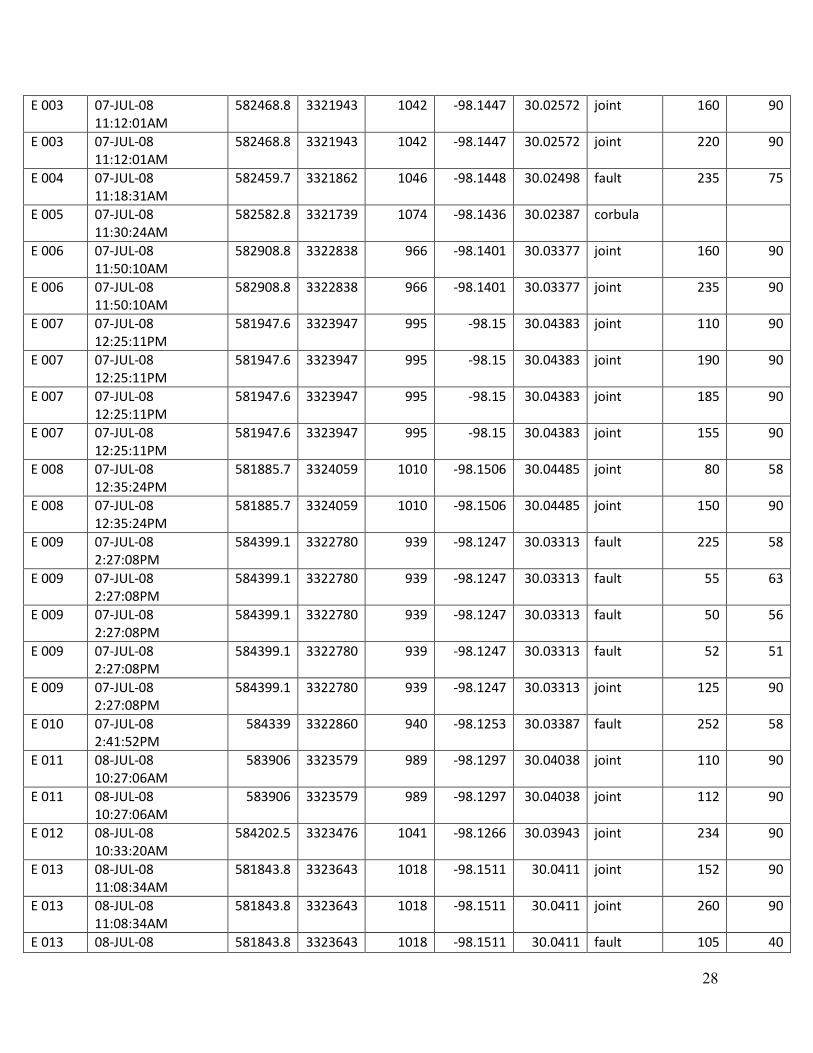
Appendix (list of data points, locations, and information)
Name Date Easting Northing Elevation Latitude Longitude Type Strike Dip
A 001 18-JUN-08 9:20:23AM
587638.2 3325313 1203 -98.0909 30.05577 joint 335 90
A 002 18-JUN-08 10:01:05AM
586973.4 3323634 1182 -98.0979 30.04067 location
A 003 18-JUN-08 10:29:59AM
586583.7 3324137 1055 -98.1019 30.04523 fault 64 70
A 003 18-JUN-08 10:29:59AM
586583.7 3324137 1055 -98.1019 30.04523 fault 50 60
A 003 18-JUN-08 10:29:59AM
586583.7 3324137 1055 -98.1019 30.04523 joint 134 90
A 003 18-JUN-08 10:29:59AM
586583.7 3324137 1055 -98.1019 30.04523 joint 224 90
A 003 18-JUN-08 10:29:59AM
586583.7 3324137 1055 -98.1019 30.04523 joint 246 90
A 003 18-JUN-08 10:29:59AM
586583.7 3324137 1055 -98.1019 30.04523 joint 156 90
A 004 18-JUN-08 11:12:16AM
586790.3 3321989 980 -98.0999 30.02583 corbula
A 005 18-JUN-08 11:26:27AM
588242.3 3320693 948 -98.085 30.01403 joint 332 90
A 005 18-JUN-08 11:26:27AM
588242.3 3320693 948 -98.085 30.01403 joint 242 90
A 005 18-JUN-08 11:26:27AM
588242.3 3320693 948 -98.085 30.01403 joint 334 90
A 005 18-JUN-08 11:26:27AM
588242.3 3320693 948 -98.085 30.01403 joint 244 90
A 006 18-JUN-08 11:55:01AM
587673 3319517 854 -98.091 30.00347 corbula
A 007 18-JUN-08 2:26:38PM
583628.8 3322628 939 -98.1327 30.03182 corbula
A 008 20-JUN-08 10:45:49AM
586745.1 3325284 1077 -98.1001 30.05557 corbula
A 009 20-JUN-08 11:28:14AM
586072.3 3325428 1102 -98.1071 30.05692 corbula
A 010 20-JUN-08 12:19:52PM
586449.7 3325662 1080 -98.1032 30.059 corbula
A 011 20-JUN-08 12:33:09PM
586377.5 3325440 1088 -98.1039 30.057 corbula
B 001 23-JUN-08 10:35:01AM
587522.3 3326753 1272 -98.0919 30.06877 joint 215 90
B 001 23-JUN-08 10:35:01AM
587522.3 3326753 1272 -98.0919 30.06877 joint 304 90

24
B 001 23-JUN-08 10:35:01AM
587522.3 3326753 1272 -98.0919 30.06877 joint 110 58
B 001 23-JUN-08 10:35:01AM
587522.3 3326753 1272 -98.0919 30.06877 joint 310 90
B 001 23-JUN-08 10:35:01AM
587522.3 3326753 1272 -98.0919 30.06877 joint 105 69
B 001 23-JUN-08 10:35:01AM
587522.3 3326753 1272 -98.0919 30.06877 joint 305 90
B 001 23-JUN-08 10:35:01AM
587522.3 3326753 1272 -98.0919 30.06877 joint 220 90
B 001 23-JUN-08 10:35:01AM
587522.3 3326753 1272 -98.0919 30.06877 joint 223 90
B 001 23-JUN-08 10:35:01AM
587522.3 3326753 1272 -98.0919 30.06877 joint 280 90
B 001 23-JUN-08 10:35:01AM
587522.3 3326753 1272 -98.0919 30.06877 fault 105 51
B 001 23-JUN-08 10:35:01AM
587522.3 3326753 1272 -98.0919 30.06877 fault 100 55
B 001 23-JUN-08 10:35:01AM
587522.3 3326753 1272 -98.0919 30.06877 fault 100 50
B 001 23-JUN-08 10:35:01AM
587522.3 3326753 1272 -98.0919 30.06877 joint 280 90
B 001 23-JUN-08 10:35:01AM
587522.3 3326753 1272 -98.0919 30.06877 joint 328 90
B 001 23-JUN-08 10:35:01AM
587522.3 3326753 1272 -98.0919 30.06877 joint 330 90
B 001 23-JUN-08 10:35:01AM
587522.3 3326753 1272 -98.0919 30.06877 joint 240 90
B 001 23-JUN-08 10:35:01AM
587522.3 3326753 1272 -98.0919 30.06877 fault 108 56
B 001 23-JUN-08 10:35:01AM
587522.3 3326753 1272 -98.0919 30.06877 joint 180 90
B 002 23-JUN-08 12:33:26PM
583964.3 3322050 1021 -98.1292 30.02658 joint 284 90
B 003 23-JUN-08 12:41:55PM
583979.7 3322141 1004 -98.1291 30.0274 joint 342 90
B 003 23-JUN-08 12:41:55PM
583979.7 3322141 1004 -98.1291 30.0274 joint 263 90
B 004 23-JUN-08 1:08:17PM
582824.8 3321181 1096 -98.1411 30.01882 joint 305 90
B 004 23-JUN-08 1:08:17PM
582824.8 3321181 1096 -98.1411 30.01882 joint 305 90
B 004 23-JUN-08 1:08:17PM
582824.8 3321181 1096 -98.1411 30.01882 joint 12 90
B 005 24-JUN-08 1:15:13PM
584237.2 3326502 1187 -98.126 30.06673 joint 155 90
B 005 24-JUN-08 584237.2 3326502 1187 -98.126 30.06673 joint 156 90

25
1:15:13PM
B 005 24-JUN-08 1:15:13PM
584237.2 3326502 1187 -98.126 30.06673 joint 60 90
B 006 24-JUN-08 1:32:53PM
584214.4 3325081 1127 -98.1264 30.05392 corbula
B 007 24-JUN-08 2:08:44PM
580656.1 3327835 1127 -98.1631 30.079 joint 115 90
B 007 24-JUN-08 2:08:44PM
580656.1 3327835 1127 -98.1631 30.079 joint 194 90
B 007 24-JUN-08 2:08:44PM
580656.1 3327835 1127 -98.1631 30.079 joint 209 90
B 007 24-JUN-08 2:08:44PM
580656.1 3327835 1127 -98.1631 30.079 joint 110 90
B 007 24-JUN-08 2:08:44PM
580656.1 3327835 1127 -98.1631 30.079 joint 208 90
B 008 24-JUN-08 2:17:27PM
580493.3 3328129 1151 -98.1648 30.08167 joint 330 90
B 008 24-JUN-08 2:17:27PM
580493.3 3328129 1151 -98.1648 30.08167 joint 258 90
B 008 24-JUN-08 2:17:27PM
580493.3 3328129 1151 -98.1648 30.08167 joint 261 90
B 008 24-JUN-08 2:17:27PM
580493.3 3328129 1151 -98.1648 30.08167 joint 340 90
B 009 24-JUN-08 2:38:53PM
579183.4 3328234 1150 -98.1783 30.0827 fault 200 90
B 009 24-JUN-08 2:38:53PM
579183.4 3328234 1150 -98.1783 30.0827 joint 155 90
B 009 24-JUN-08 2:38:53PM
579183.4 3328234 1150 -98.1783 30.0827 joint 283 90
B 009 24-JUN-08 2:38:53PM
579183.4 3328234 1150 -98.1783 30.0827 joint 27 90
B 009 24-JUN-08 2:38:53PM
579183.4 3328234 1150 -98.1783 30.0827 joint 105 90
B 010 24-JUN-08 3:04:29PM
578327 3328272 1271 -98.1872 30.0831 location
B 011 25-JUN-08 10:23:18AM
577211.1 3324770 1142 -98.1991 30.05157 joint 54 90
B 012 25-JUN-08 10:38:56AM
577446 3325181 1167 -98.1966 30.05527 joint 73 80
B 013 25-JUN-08 11:04:12AM
577542.9 3328754 1311 -98.1953 30.0875 joint 260 90
B 013 25-JUN-08 11:04:12AM
577542.9 3328754 1311 -98.1953 30.0875 joint 240 65
B 013 25-JUN-08 11:04:12AM
577542.9 3328754 1311 -98.1953 30.0875 joint 115 90
B 013 25-JUN-08 11:04:12AM
577542.9 3328754 1311 -98.1953 30.0875 joint 116 90

26
B 014 25-JUN-08 11:36:50AM
577875 3330402 1331 -98.1918 30.10235 joint 192 90
B 014 25-JUN-08 11:36:50AM
577875 3330402 1331 -98.1918 30.10235 joint 130 90
B 015 25-JUN-08 11:54:57AM
580032.8 3332473 1241 -98.1692 30.1209 joint 105 90
B 015 25-JUN-08 11:54:57AM
580032.8 3332473 1241 -98.1692 30.1209 joint 165 90
B 015 25-JUN-08 11:54:57AM
580032.8 3332473 1241 -98.1692 30.1209 joint 105 90
B 016 25-JUN-08 12:41:03PM
581686.5 3334440 1188 -98.1519 30.13853 joint 335 90
B 016 25-JUN-08 12:41:03PM
581686.5 3334440 1188 -98.1519 30.13853 joint 320 90
C 001 30-JUN-08 10:50:20AM
576304.3 3324388 1203 -98.2085 30.04818 joint 245 90
C 001 30-JUN-08 10:50:20AM
576304.3 3324388 1203 -98.2085 30.04818 joint 160 90
C 002 30-JUN-08 11:17:45AM
576472.1 3323592 1208 -98.2068 30.04098 corbula
C 003 30-JUN-08 12:26:46PM
578059.7 3319510 1029 -98.1906 30.00405 joint 325 90
C 003 30-JUN-08 12:26:46PM
578059.7 3319510 1029 -98.1906 30.00405 joint 25 90
C 003 30-JUN-08 12:26:46PM
578059.7 3319510 1029 -98.1906 30.00405 joint 323 90
C 003 30-JUN-08 12:26:46PM
578059.7 3319510 1029 -98.1906 30.00405 joint 315 90
C 004 30-JUN-08 12:54:40PM
577127.4 3317878 955 -98.2004 29.98938 joint or fault
230 90
C 005 30-JUN-08 1:10:52PM
574622.2 3318873 1118 -98.2263 29.99852 corbula
C 006 30-JUN-08 1:19:49PM
574742.4 3318933 1117 -98.2251 29.99905 corbula
C 007 30-JUN-08 1:22:00PM
574729.2 3318979 1120 -98.2252 29.99947 corbula
C 009 01-JUL-08 12:31:18PM
591520.2 3319885 923 -98.0511 30.0065 joint 40 90
C 009 01-JUL-08 12:31:18PM
591520.2 3319885 923 -98.0511 30.0065 joint 332 90
C 009 01-JUL-08 12:31:18PM
591520.2 3319885 923 -98.0511 30.0065 joint 331 90
C 009 01-JUL-08 12:31:18PM
591520.2 3319885 923 -98.0511 30.0065 joint 240 45
C 010 01-JUL-08 1:08:49PM
589945.7 3320755 969 -98.0673 30.01447 joint 75 90
C 010 01-JUL-08 589945.7 3320755 969 -98.0673 30.01447 joint 345 90

27
1:08:49PM
D 001 02-JUL-08 12:27:42PM
580205.6 3325504 1036 -98.1679 30.058 joint 332 90
D 002 02-JUL-08 12:38:18PM
580054.8 3325479 1036 -98.1695 30.05778 joint 335 90
D 002 02-JUL-08 12:38:18PM
580054.8 3325479 1036 -98.1695 30.05778 joint 325 90
D 002 02-JUL-08 12:38:18PM
580054.8 3325479 1036 -98.1695 30.05778 joint 60 90
D 003 02-JUL-08 12:49:12PM
579958.1 3325515 1033 -98.1705 30.05812 fault 256 61
D 004 02-JUL-08 12:57:28PM
579887.4 3325513 1040 -98.1712 30.0581 joint 320 90
D 004 02-JUL-08 12:57:28PM
579887.4 3325513 1040 -98.1712 30.0581 joint 321 90
D 005 02-JUL-08 1:03:33PM
579738.6 3325427 1034 -98.1728 30.05733 joint 328 90
D 005 02-JUL-08 1:03:33PM
579738.6 3325427 1034 -98.1728 30.05733 joint 318 90
D 006 02-JUL-08 2:06:56PM
580511.6 3325406 1016 -98.1648 30.0571 joint 325 90
D 007 02-JUL-08 2:11:09PM
580573.9 3325455 1018 -98.1641 30.05753 joint 330 90
D 008 02-JUL-08 2:15:23PM
580692.4 3325506 1016 -98.1629 30.05798 joint 330 90
D 009 02-JUL-08 2:42:28PM
580337.5 3325706 1040 -98.1666 30.05982 joint or fault
235 90
D 010 02-JUL-08 2:48:24PM
580334.1 3325734 1056 -98.1666 30.06007 fault 236 90
D 011 02-JUL-08 2:55:30PM
580240.4 3325798 1058 -98.1676 30.06065 joint 335 90
D 012 02-JUL-08 3:03:43PM
580203 3325860 1062 -98.1679 30.06122 joint 325 90
D 013 02-JUL-08 3:06:58PM
580192.8 3325940 1062 -98.168 30.06193 joint 330 90
D 014 02-JUL-08 3:10:44PM
580123.7 3325949 1062 -98.1688 30.06202 joint 333 90
D 014 02-JUL-08 3:10:44PM
580123.7 3325949 1062 -98.1688 30.06202 joint 245 90
E 001 07-JUL-08 10:38:06AM
583051.6 3321809 1074 -98.1387 30.02447 corbula
E 002 07-JUL-08 11:08:06AM
582481.2 3322000 1035 -98.1446 30.02623 joint 215 90
E 002 07-JUL-08 11:08:06AM
582481.2 3322000 1035 -98.1446 30.02623 joint 185 90
E 002 07-JUL-08 11:08:06AM
582481.2 3322000 1035 -98.1446 30.02623 joint 260 90
28
E 003 07-JUL-08 11:12:01AM
582468.8 3321943 1042 -98.1447 30.02572 joint 160 90
E 003 07-JUL-08 11:12:01AM
582468.8 3321943 1042 -98.1447 30.02572 joint 220 90
E 004 07-JUL-08 11:18:31AM
582459.7 3321862 1046 -98.1448 30.02498 fault 235 75
E 005 07-JUL-08 11:30:24AM
582582.8 3321739 1074 -98.1436 30.02387 corbula
E 006 07-JUL-08 11:50:10AM
582908.8 3322838 966 -98.1401 30.03377 joint 160 90
E 006 07-JUL-08 11:50:10AM
582908.8 3322838 966 -98.1401 30.03377 joint 235 90
E 007 07-JUL-08 12:25:11PM
581947.6 3323947 995 -98.15 30.04383 joint 110 90
E 007 07-JUL-08 12:25:11PM
581947.6 3323947 995 -98.15 30.04383 joint 190 90
E 007 07-JUL-08 12:25:11PM
581947.6 3323947 995 -98.15 30.04383 joint 185 90
E 007 07-JUL-08 12:25:11PM
581947.6 3323947 995 -98.15 30.04383 joint 155 90
E 008 07-JUL-08 12:35:24PM
581885.7 3324059 1010 -98.1506 30.04485 joint 80 58
E 008 07-JUL-08 12:35:24PM
581885.7 3324059 1010 -98.1506 30.04485 joint 150 90
E 009 07-JUL-08 2:27:08PM
584399.1 3322780 939 -98.1247 30.03313 fault 225 58
E 009 07-JUL-08 2:27:08PM
584399.1 3322780 939 -98.1247 30.03313 fault 55 63
E 009 07-JUL-08 2:27:08PM
584399.1 3322780 939 -98.1247 30.03313 fault 50 56
E 009 07-JUL-08 2:27:08PM
584399.1 3322780 939 -98.1247 30.03313 fault 52 51
E 009 07-JUL-08 2:27:08PM
584399.1 3322780 939 -98.1247 30.03313 joint 125 90
E 010 07-JUL-08 2:41:52PM
584339 3322860 940 -98.1253 30.03387 fault 252 58
E 011 08-JUL-08 10:27:06AM
583906 3323579 989 -98.1297 30.04038 joint 110 90
E 011 08-JUL-08 10:27:06AM
583906 3323579 989 -98.1297 30.04038 joint 112 90
E 012 08-JUL-08 10:33:20AM
584202.5 3323476 1041 -98.1266 30.03943 joint 234 90
E 013 08-JUL-08 11:08:34AM
581843.8 3323643 1018 -98.1511 30.0411 joint 152 90
E 013 08-JUL-08 11:08:34AM
581843.8 3323643 1018 -98.1511 30.0411 joint 260 90
E 013 08-JUL-08 581843.8 3323643 1018 -98.1511 30.0411 fault 105 40

29
11:08:34AM
E 014 08-JUL-08 11:23:41AM
581867 3323760 1010 -98.1508 30.04215 joint 105 90
E 015 08-JUL-08 11:32:03AM
581918.1 3323810 1008 -98.1503 30.0426 joint 125 90
F 001 09-JUL-08 10:44:43AM
575598.2 3329631 1343 -98.2154 30.09553 joint 198 90
F 001 09-JUL-08 10:44:43AM
575598.2 3329631 1343 -98.2154 30.09553 joint 285 90
F 002 09-JUL-08 10:51:46AM
573589 3330112 1287 -98.2363 30.1 joint 125 90
F 002 09-JUL-08 10:51:46AM
573589 3330112 1287 -98.2363 30.1 joint 225 90
F 003 09-JUL-08 11:00:29AM
572713.4 3329920 1243 -98.2454 30.09832 joint 55 90
F 004 09-JUL-08 11:17:06AM
569902.8 3331956 1365 -98.2744 30.11685 joint 320 90
F 004 09-JUL-08 11:17:06AM
569902.8 3331956 1365 -98.2744 30.11685 joint 195 90
F 005 09-JUL-08 11:25:31AM
570294.6 3332215 1308 -98.2703 30.11917 joint 322 90
F 005 09-JUL-08 11:25:31AM
570294.6 3332215 1308 -98.2703 30.11917 joint 322 90
F 005 09-JUL-08 11:25:31AM
570294.6 3332215 1308 -98.2703 30.11917 joint 215 90
F 006 09-JUL-08 11:41:28AM
573451.7 3331447 1320 -98.2376 30.11205 joint 315 90
F 007 09-JUL-08 11:48:15AM
574430.5 3331311 1465 -98.2274 30.11077 joint 110 90
F 007 09-JUL-08 11:48:15AM
574430.5 3331311 1465 -98.2274 30.11077 joint 130 90
F 007 09-JUL-08 11:48:15AM
574430.5 3331311 1465 -98.2274 30.11077 joint 335 90
F 008 09-JUL-08 12:05:24PM
573972.4 3332817 1589 -98.2321 30.12438 joint 135 90
F 008 09-JUL-08 12:05:24PM
573972.4 3332817 1589 -98.2321 30.12438 joint 220 90
F 009 09-JUL-08 12:33:35PM
571558.4 3332186 1387 -98.2572 30.11883 joint 125 90
F 009 09-JUL-08 12:33:35PM
571558.4 3332186 1387 -98.2572 30.11883 joint 165 90
F 009 09-JUL-08 12:33:35PM
571558.4 3332186 1387 -98.2572 30.11883 joint 210 90
G 001 14-JUL-08 10:00:18AM
578166.4 3337975 1233 -98.1882 30.17067 joint 230 90
G 001 14-JUL-08 10:00:18AM
578166.4 3337975 1233 -98.1882 30.17067 joint 320 90

30
G 001 14-JUL-08 10:00:18AM
578166.4 3337975 1233 -98.1882 30.17067 joint 185 90
G 002 14-JUL-08 10:10:06AM
579997.8 3332440 1259 -98.1696 30.1206 joint 275 90
G 002 14-JUL-08 10:10:06AM
579997.8 3332440 1259 -98.1696 30.1206 joint 135 90
G 003 14-JUL-08 10:52:47AM
580945.2 3327408 1103 -98.1601 30.07513 joint 105 90
G 004 14-JUL-08 11:17:06AM
582889.4 3328414 1308 -98.1399 30.08408 joint 315 90
G 004 14-JUL-08 11:17:06AM
582889.4 3328414 1308 -98.1399 30.08408 joint 235 90
G 004 14-JUL-08 11:17:06AM
582889.4 3328414 1308 -98.1399 30.08408 joint 325 90
G 005 14-JUL-08 12:37:09PM
582961 3327015 1192 -98.1392 30.07145 joint 245 90
G 005 14-JUL-08 12:37:09PM
582961 3327015 1192 -98.1392 30.07145 joint 250 90
G 005 14-JUL-08 12:37:09PM
582961 3327015 1192 -98.1392 30.07145 joint 170 90
G 005 14-JUL-08 12:37:09PM
582961 3327015 1192 -98.1392 30.07145 joint 235 90
G 005 14-JUL-08 12:37:09PM
582961 3327015 1192 -98.1392 30.07145 joint 135 90
H 001 15-JUL-08 9:54:12AM
580304.6 3325143 1081 -98.1669 30.05473 joint 240 90
H 002 15-JUL-08 10:17:11AM
580407.8 3324658 1147 -98.1659 30.05035 corbula
H 003 15-JUL-08 10:24:23AM
580365.1 3324571 1164 -98.1664 30.04957 joint 135 90
H 003 15-JUL-08 10:24:23AM
580365.1 3324571 1164 -98.1664 30.04957 joint 234 90
H 003 15-JUL-08 10:24:23AM
580365.1 3324571 1164 -98.1664 30.04957 joint 140 90
H 003 15-JUL-08 10:24:23AM
580365.1 3324571 1164 -98.1664 30.04957 joint 238 90
H 003 15-JUL-08 10:24:23AM
580365.1 3324571 1164 -98.1664 30.04957 joint 236 90
H 003 15-JUL-08 10:24:23AM
580365.1 3324571 1164 -98.1664 30.04957 joint 150 90
H 004 15-JUL-08 10:41:18AM
580470 3324499 1160 -98.1653 30.04892 corbula
H 005 15-JUL-08 10:57:15AM
580505.4 3324490 1157 -98.1649 30.04883 corbula
H 006 15-JUL-08 11:02:28AM
580639.5 3324617 1156 -98.1635 30.04997 corbula
H 007 15-JUL-08 580734.1 3324642 1155 -98.1625 30.05018 corbula

31
11:05:43AM
H 008 15-JUL-08 11:08:21AM
580701.1 3324543 1160 -98.1629 30.0493 corbula
H 009 15-JUL-08 11:13:24AM
580787.4 3324382 1166 -98.162 30.04783 corbula
H 010 15-JUL-08 11:17:28AM
580975.1 3324433 1159 -98.16 30.04828 corbula
H 011 15-JUL-08 11:21:19AM
581068.4 3324406 1159 -98.1591 30.04803 corbula
H 012 15-JUL-08 11:23:20AM
581070.4 3324358 1161 -98.1591 30.0476 corbula
H 013 15-JUL-08 11:25:36AM
581035.4 3324308 1169 -98.1594 30.04715 corbula
H 014 15-JUL-08 11:30:58AM
580971.7 3324231 1166 -98.1601 30.04647 corbula
H 016 15-JUL-08 12:10:14PM
580721.4 3323962 1111 -98.1627 30.04405 joint 175 90
H 016 15-JUL-08 12:10:14PM
580721.4 3323962 1111 -98.1627 30.04405 joint 268 90
H 016 15-JUL-08 12:10:14PM
580721.4 3323962 1111 -98.1627 30.04405 joint 160 90
H 017 15-JUL-08 12:19:01PM
580771.6 3324123 1139 -98.1622 30.0455 joint 70 90
H 018 15-JUL-08 12:22:02PM
580779.2 3324189 1152 -98.1621 30.0461 corbula
H 019 15-JUL-08 12:44:42PM
580774.6 3325255 1101 -98.1621 30.05572 corbula
H 020 15-JUL-08 1:52:38PM
579989.1 3325892 1078 -98.1702 30.06152 joint 150 90
H 020 15-JUL-08 1:52:38PM
579989.1 3325892 1078 -98.1702 30.06152 joint 235 90
H 020 15-JUL-08 1:52:38PM
579989.1 3325892 1078 -98.1702 30.06152 joint 240 90
H 020 15-JUL-08 1:52:38PM
579989.1 3325892 1078 -98.1702 30.06152 joint 135 90
H 021 15-JUL-08 1:58:33PM
579902 3325934 1079 -98.1711 30.0619 joint 145 90
H 021 15-JUL-08 1:58:33PM
579902 3325934 1079 -98.1711 30.0619 joint 245 90
H 021 15-JUL-08 1:58:33PM
579902 3325934 1079 -98.1711 30.0619 joint 190 90
H 022 15-JUL-08 2:06:12PM
579838.9 3325994 1081 -98.1717 30.06245 joint 245 90
H 022 15-JUL-08 2:06:12PM
579838.9 3325994 1081 -98.1717 30.06245 joint 145 90
H 023 15-JUL-08 2:09:52PM
579801.6 3326053 1081 -98.1721 30.06298 joint 125 90

32
H 023 15-JUL-08 2:09:52PM
579801.6 3326053 1081 -98.1721 30.06298 joint 135 90
H 023 15-JUL-08 2:09:52PM
579801.6 3326053 1081 -98.1721 30.06298 joint 0 90
H 023 15-JUL-08 2:09:52PM
579801.6 3326053 1081 -98.1721 30.06298 joint 245 90
H 024 15-JUL-08 2:18:52PM
579776.6 3326173 1077 -98.1723 30.06407 fault 110 65
H 025 15-JUL-08 2:29:48PM
579710.6 3326186 1077 -98.173 30.06418 joint 115 90
H 025 15-JUL-08 2:29:48PM
579710.6 3326186 1077 -98.173 30.06418 joint 245 90
H 025 15-JUL-08 2:29:48PM
579710.6 3326186 1077 -98.173 30.06418 joint 145 90
H 015 15-JUL-08 11:36:34AM
580898.4 3324144 1163 -98.1609 30.04568 corbula
I 001 21-JUL-08 10:09:25AM
581138.5 3325583 947 -98.1583 30.05865 joint 150 90
I 002 21-JUL-08 10:30:27AM
577560.5 3325577 1095 -98.1954 30.05883 joint 180 90
I 002 21-JUL-08 10:30:27AM
577560.5 3325577 1095 -98.1954 30.05883 joint 115 90
I 002 21-JUL-08 10:30:27AM
577560.5 3325577 1095 -98.1954 30.05883 joint 260 90
I 002 21-JUL-08 10:30:27AM
577560.5 3325577 1095 -98.1954 30.05883 joint 150 90
I 002 21-JUL-08 10:30:27AM
577560.5 3325577 1095 -98.1954 30.05883 joint 140 90
I 002 21-JUL-08 10:30:27AM
577560.5 3325577 1095 -98.1954 30.05883 joint 110 90
I 002 21-JUL-08 10:30:27AM
577560.5 3325577 1095 -98.1954 30.05883 joint 95 90
I 002 21-JUL-08 10:30:27AM
577560.5 3325577 1095 -98.1954 30.05883 joint 150 90
I 002 21-JUL-08 10:30:27AM
577560.5 3325577 1095 -98.1954 30.05883 joint 245 90
I 002 21-JUL-08 10:30:27AM
577560.5 3325577 1095 -98.1954 30.05883 joint 150 90
I 003 21-JUL-08 10:45:55AM
577553.5 3326564 1168 -98.1954 30.06773 joint 115 90
I 003 21-JUL-08 10:45:55AM
577553.5 3326564 1168 -98.1954 30.06773 joint 150 90
I 004 21-JUL-08 10:54:55AM
577414.5 3328055 1236 -98.1967 30.0812 joint 148 90
I 004 21-JUL-08 10:54:55AM
577414.5 3328055 1236 -98.1967 30.0812 joint 227 90
I 005 21-JUL-08 581750.2 3327601 1189 -98.1518 30.07682 joint 140 90

33
11:07:03AM
I 005 21-JUL-08 11:07:03AM
581750.2 3327601 1189 -98.1518 30.07682 joint 115 90
I 005 21-JUL-08 11:07:03AM
581750.2 3327601 1189 -98.1518 30.07682 joint 185 90
I 005 21-JUL-08 11:07:03AM
581750.2 3327601 1189 -98.1518 30.07682 joint 220 90
J 001 28-JUL-08 10:51:11AM
586615.6 3319666 930 -98.1019 30.00488 joint 125 90
J 001 28-JUL-08 10:51:11AM
586615.6 3319666 930 -98.1019 30.00488 joint 215 65
J 001 28-JUL-08 10:51:11AM
586615.6 3319666 930 -98.1019 30.00488 joint 155 90
J 002 28-JUL-08 11:19:09AM
574023.9 3324196 1035 -98.2322 30.04658 joint 140 90
J 003 28-JUL-08 11:37:24AM
573887.9 3323147 1083 -98.2336 30.03713 joint 115 90
J 003 28-JUL-08 11:37:24AM
573887.9 3323147 1083 -98.2336 30.03713 joint 225 90
J 003 28-JUL-08 11:37:24AM
573887.9 3323147 1083 -98.2336 30.03713 joint 178 90
J 004 28-JUL-08 11:49:56AM
574387.6 3322443 1074 -98.2285 30.03075 joint 145 90
J 004 28-JUL-08 11:49:56AM
574387.6 3322443 1074 -98.2285 30.03075 joint 245 90
J 005 28-JUL-08 12:03:04PM
572239.8 3321816 1187 -98.2508 30.02522 joint 145 90
J 005 28-JUL-08 12:03:04PM
572239.8 3321816 1187 -98.2508 30.02522 joint 222 90
J 006 28-JUL-08 12:15:23PM
573088.8 3321997 1147 -98.242 30.0268 joint 115 90
J 006 28-JUL-08 12:15:23PM
573088.8 3321997 1147 -98.242 30.0268 joint 165 90
J 006 28-JUL-08 12:15:23PM
573088.8 3321997 1147 -98.242 30.0268 joint 165 90
J 007 28-JUL-08 12:25:33PM
573811.6 3321337 1131 -98.2346 30.0208 joint 135 90
J 007 28-JUL-08 12:25:33PM
573811.6 3321337 1131 -98.2346 30.0208 joint 130 90
J 007 28-JUL-08 12:25:33PM
573811.6 3321337 1131 -98.2346 30.0208 joint 225 90
J 007 28-JUL-08 12:25:33PM
573811.6 3321337 1131 -98.2346 30.0208 joint 135 90
J 008 28-JUL-08 12:41:03PM
571942.3 3319858 1188 -98.254 30.00757 joint 250 90
J 008 28-JUL-08 12:41:03PM
571942.3 3319858 1188 -98.254 30.00757 joint 160 90

34
J 009 28-JUL-08 1:08:58PM
577354.2 3319244 966 -98.198 30.0017 joint 135 90
J 009 28-JUL-08 1:08:58PM
577354.2 3319244 966 -98.198 30.0017 joint 98 90
J 009 28-JUL-08 1:08:58PM
577354.2 3319244 966 -98.198 30.0017 joint 245 90
J 009 28-JUL-08 1:08:58PM
577354.2 3319244 966 -98.198 30.0017 joint 152 90
J 009 28-JUL-08 1:08:58PM
577354.2 3319244 966 -98.198 30.0017 joint 140 90
J 010 29-JUL-08 11:55:54AM
575025.4 3323177 943 -98.2218 30.03733 joint 155 90
J 011 29-JUL-08 12:05:21PM
574975 3323262 919 -98.2224 30.0381 fault 115 90
J 012 29-JUL-08 12:09:05PM
574981.1 3323314 932 -98.2223 30.03857 joint 230 90
J 012 29-JUL-08 12:09:05PM
574981.1 3323314 932 -98.2223 30.03857 joint 115 90