appendix a. aerial and underwater radiotelemetry antenna
TRANSCRIPT
Appendix A
1
Appendix A. Aerial and underwater radiotelemetry antenna
deployments at FCRPS dams: Generalized maps
These maps show approximate locations of aerial and underwater antennas that were used to
monitor radio-tagged adult salmon and steelhead at the main stem Columbia and Snake River
dams. Not all sites were deployed in all years. Please see the database:
Receiver_Deployments_1996-2014 for annual details. Appendix B provides generalized maps
of aerial antenna locations at main stem sites, including reservoirs, and in tributaries.
Appendices C-E provide additional metadata, including photos, for some sites at dams, in the
main stem rivers, and in tributaries.
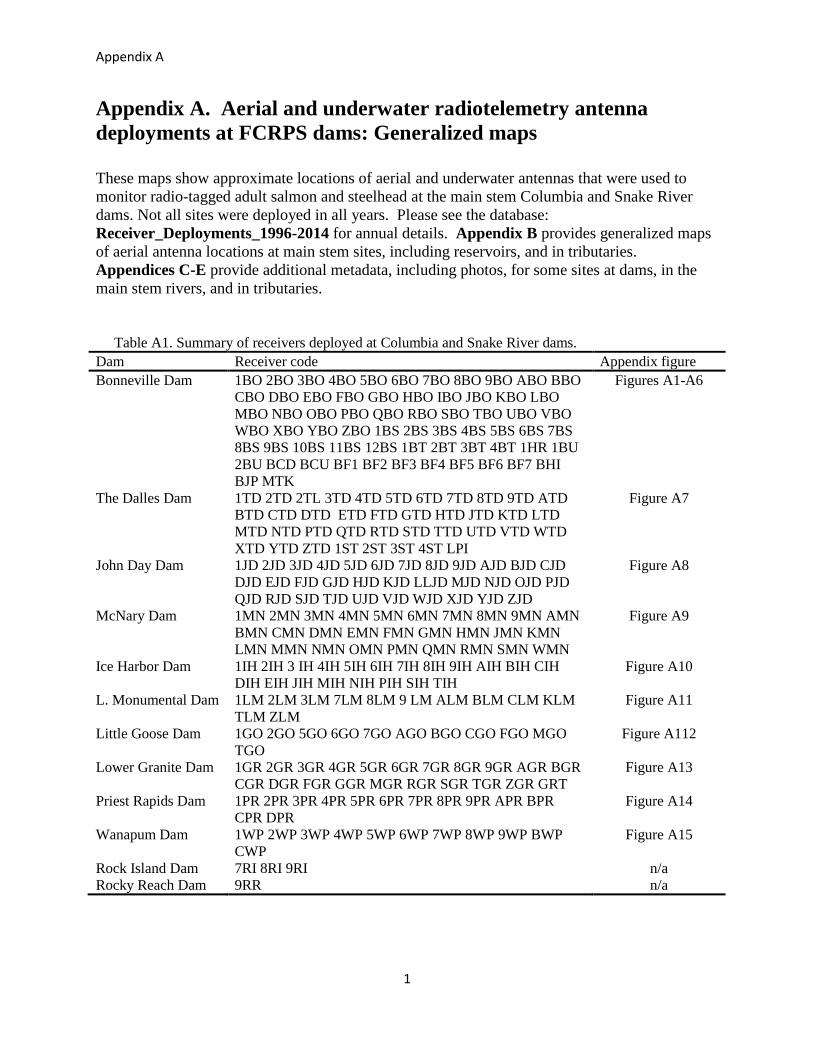
Table A1. Summary of receivers deployed at Columbia and Snake River dams.
Dam Receiver code Appendix figure
Bonneville Dam 1BO 2BO 3BO 4BO 5BO 6BO 7BO 8BO 9BO ABO BBO
CBO DBO EBO FBO GBO HBO IBO JBO KBO LBO
MBO NBO OBO PBO QBO RBO SBO TBO UBO VBO
WBO XBO YBO ZBO 1BS 2BS 3BS 4BS 5BS 6BS 7BS
8BS 9BS 10BS 11BS 12BS 1BT 2BT 3BT 4BT 1HR 1BU
2BU BCD BCU BF1 BF2 BF3 BF4 BF5 BF6 BF7 BHI
BJP MTK
Figures A1-A6
The Dalles Dam 1TD 2TD 2TL 3TD 4TD 5TD 6TD 7TD 8TD 9TD ATD
BTD CTD DTD ETD FTD GTD HTD JTD KTD LTD
MTD NTD PTD QTD RTD STD TTD UTD VTD WTD
XTD YTD ZTD 1ST 2ST 3ST 4ST LPI
Figure A7
John Day Dam 1JD 2JD 3JD 4JD 5JD 6JD 7JD 8JD 9JD AJD BJD CJD
DJD EJD FJD GJD HJD KJD LLJD MJD NJD OJD PJD
QJD RJD SJD TJD UJD VJD WJD XJD YJD ZJD
Figure A8
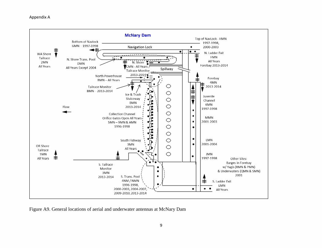
McNary Dam 1MN 2MN 3MN 4MN 5MN 6MN 7MN 8MN 9MN AMN
BMN CMN DMN EMN FMN GMN HMN JMN KMN
LMN MMN NMN OMN PMN QMN RMN SMN WMN
Figure A9
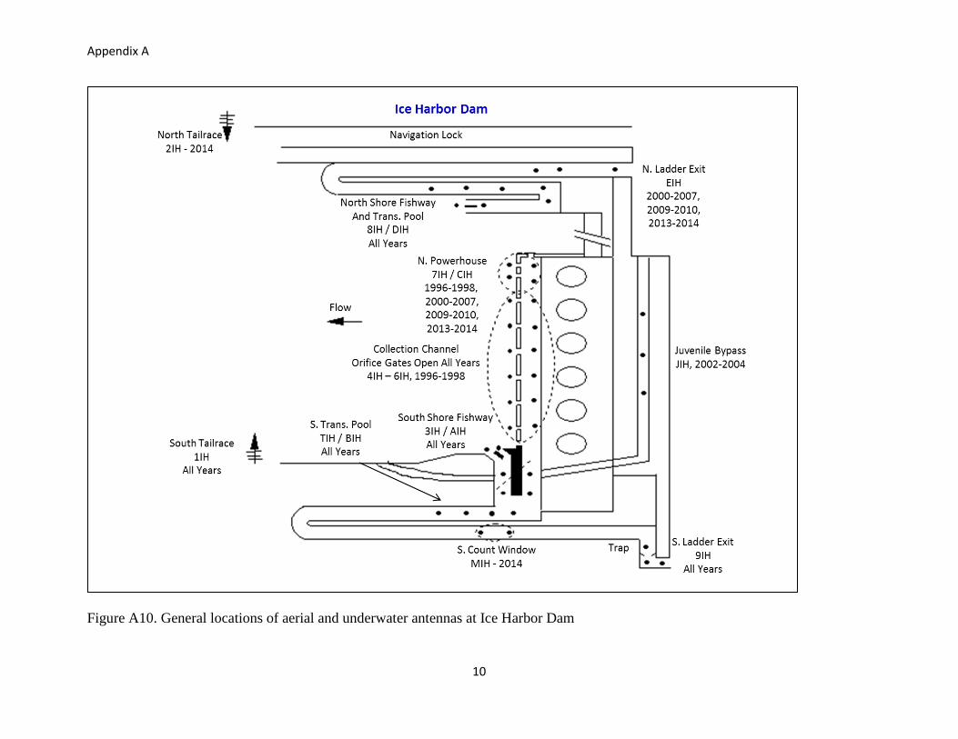
Ice Harbor Dam 1IH 2IH 3 IH 4IH 5IH 6IH 7IH 8IH 9IH AIH BIH CIH
DIH EIH JIH MIH NIH PIH SIH TIH
Figure A10
L. Monumental Dam 1LM 2LM 3LM 7LM 8LM 9 LM ALM BLM CLM KLM
TLM ZLM
Figure A11
Little Goose Dam 1GO 2GO 5GO 6GO 7GO AGO BGO CGO FGO MGO
TGO
Figure A112
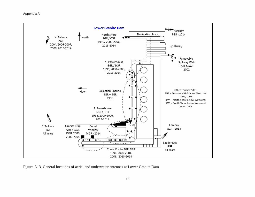
Lower Granite Dam 1GR 2GR 3GR 4GR 5GR 6GR 7GR 8GR 9GR AGR BGR
CGR DGR FGR GGR MGR RGR SGR TGR ZGR GRT
Figure A13
Priest Rapids Dam 1PR 2PR 3PR 4PR 5PR 6PR 7PR 8PR 9PR APR BPR
CPR DPR
Figure A14
Wanapum Dam 1WP 2WP 3WP 4WP 5WP 6WP 7WP 8WP 9WP BWP
CWP
Figure A15
Rock Island Dam 7RI 8RI 9RI n/a
Rocky Reach Dam 9RR n/a

Appendix A
2
Figure A1. General locations of aerial and underwater antennas at Bonneville Dam, Powerhouse 1 and B-Branch

Appendix A
3
Figure A2. General locations of aerial and underwater antennas at Bonneville Dam, Powerhouse 2 and Cascades Island

Appendix A
4
Figure A4. General locations of aerial antennas in the Bonneville spillway forebay
Appendix A
5
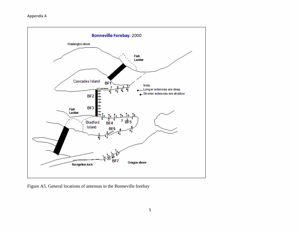
Figure A5. General locations of antennas in the Bonneville forebay

Appendix A
6
Figure A6. General locations of antennas in the Bonneville spillway tailrace
Appendix A
7
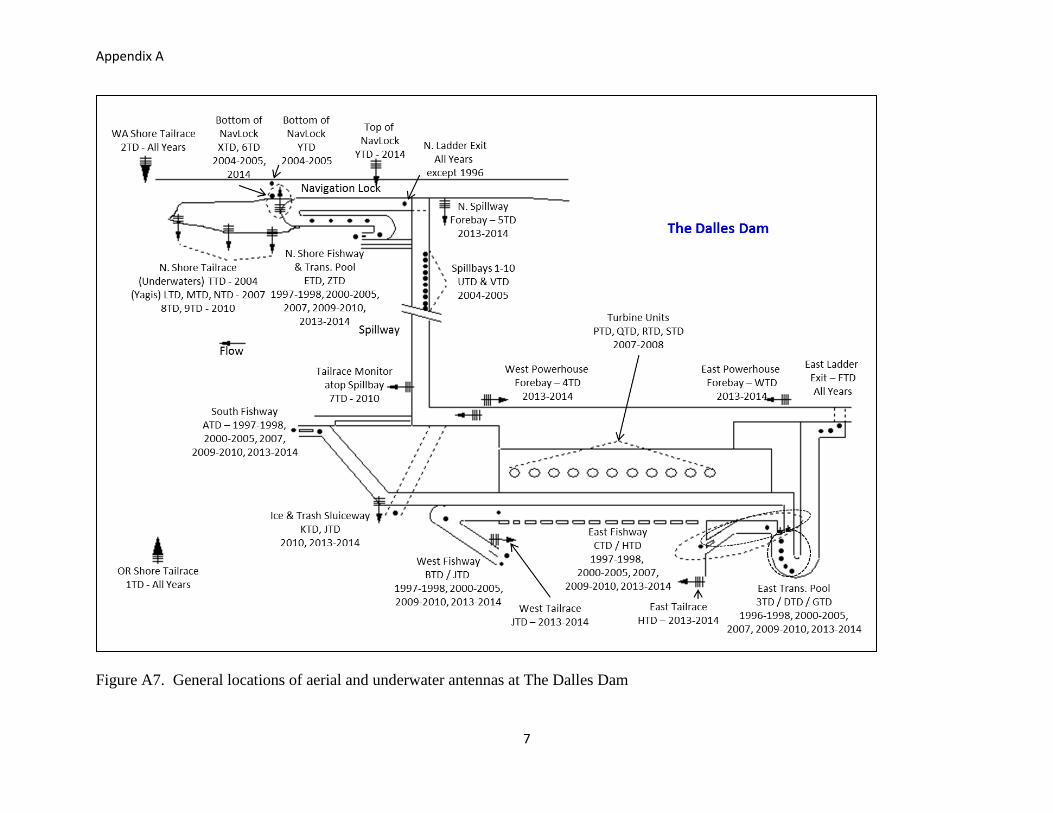
Figure A7. General locations of aerial and underwater antennas at The Dalles Dam
Appendix A
8
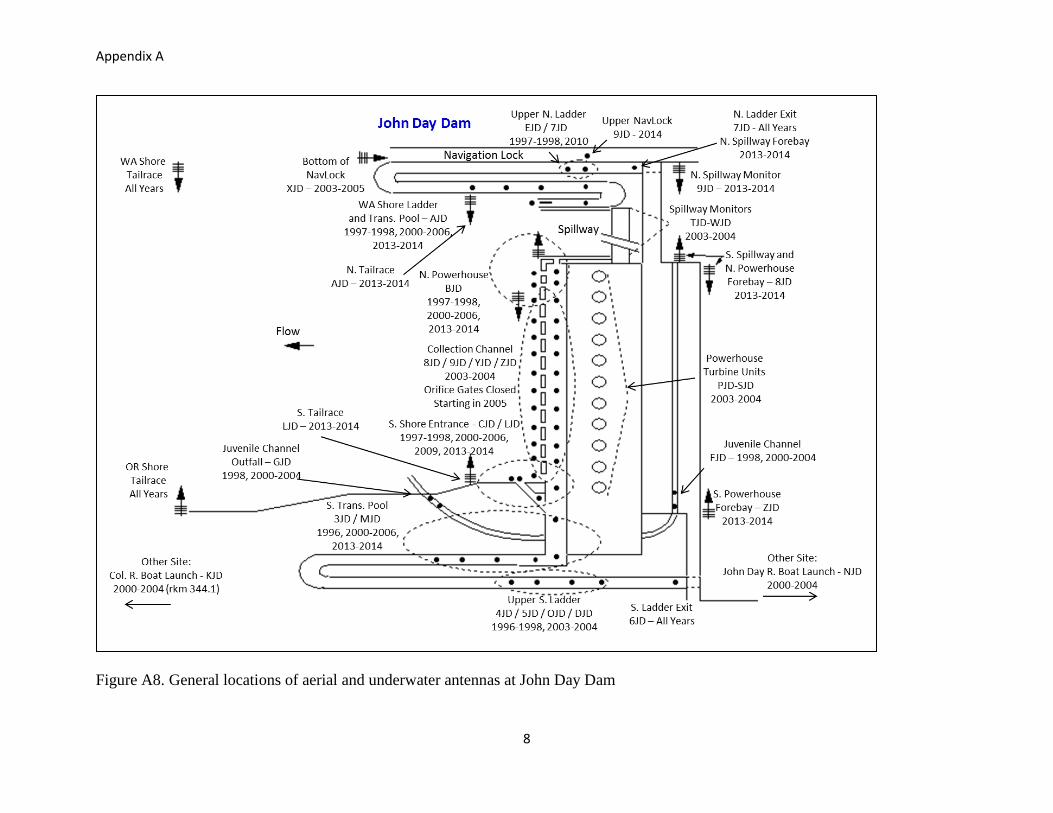
Figure A8. General locations of aerial and underwater antennas at John Day Dam
Appendix A
9
Figure A9. General locations of aerial and underwater antennas at McNary Dam
Appendix A
10
Figure A10. General locations of aerial and underwater antennas at Ice Harbor Dam

Appendix A
11
Figure A11. General locations of aerial and underwater antennas at Lower Monumental Dam

Appendix A
12
Figure A12. General locations of aerial and underwater antennas at Little Goose Dam
Appendix A
13
Figure A13. General locations of aerial and underwater antennas at Lower Granite Dam

Appendix A
14
Figure A14. General locations of aerial and underwater antennas at Lower Granite Dam

Appendix A
15
Figure A15. General locations of aerial and underwater antennas (black boxes) at Wanapum Dam
Wanapum Dam