appendix a - figures - south dakota public utilities...
TRANSCRIPT

APPENDIX A - FIGURES
Se
rvic
e L
aye
r C
red
its:
B u t t eB u t t eC o u n t yC o u n t y
H a r d i n gH a r d i n gC o u n t yC o u n t y
M e a d eM e a d eC o u n t yC o u n t y
P e r k i n sP e r k i n sC o u n t yC o u n t y
ST79
ST34
ST168
ST79
£¤212
£¤212
CastleRock
Vale
Hoover
MudButte
Newell
CO
PY
RIG
HT
© 2
01
5 B
UR
NS
& M
cDO
NN
EL
L E
NG
INE
ER
ING
CO
MP
AN
Y,
INC
.
Source: ESRI Data 2013; USGS Topographic Map, DRG mosaic, Butte County, ND Issued: 5/15/2015
Pa
th: Z
:\C
lien
ts\E
SP
\Win
dQ
ua
rry\
840
46
_W
illo
wC
ree
k\S
tud
ies\
Ge
osp
atia
l\Da
taF
iles\
Arc
Do
cs\F
igu
re1
_P
roje
ctLo
catio
n.m
xd
bpa
rke
r
5/1
5/2
01
5
NORTH
0 52.5
Miles
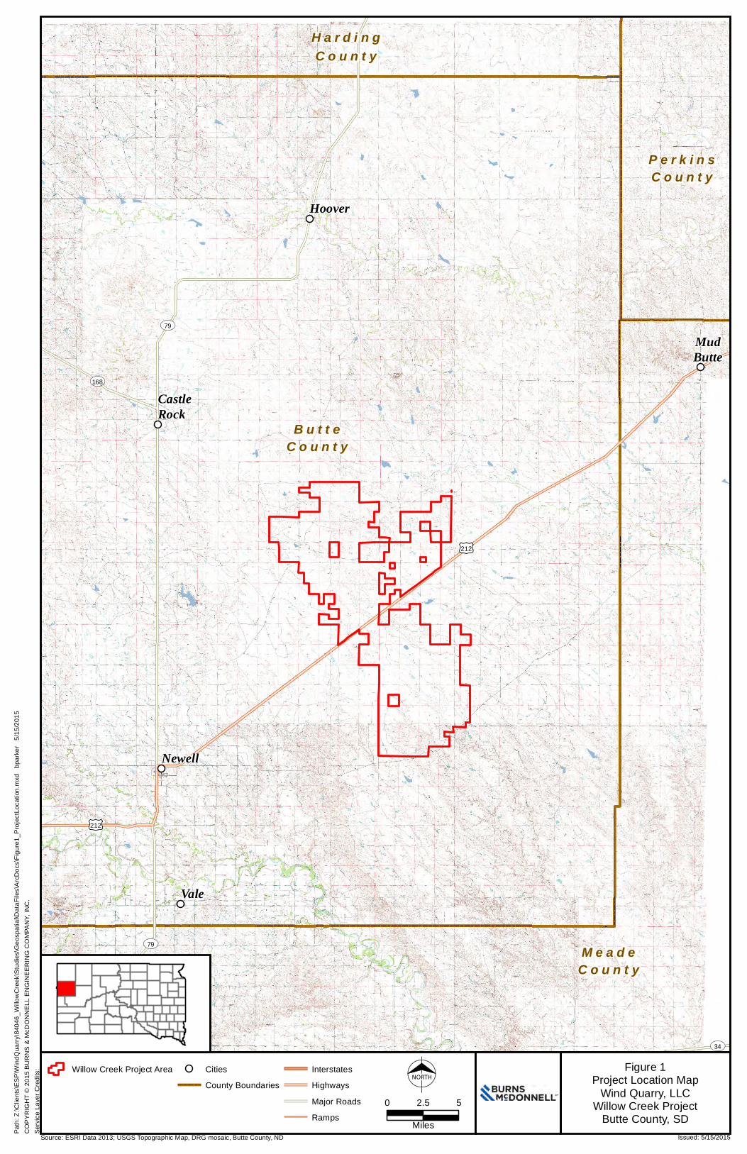
Figure 1Project Location Map
Wind Quarry, LLCWillow Creek Project
Butte County, SD
Willow Creek Project Area Cities
County Boundaries
Interstates
Highways
Major Roads
Ramps

Figure 2
South Dakota - Wind Resource Map
46° -
440
Indian h ' Reservations .
r:oi . Meteorological Station with Wind Data L!.J Standing Rock City or Town
- W Cheyenne River ------------=====''--
Wind Power Classification Wind Resource Wind Power Wind Speed8 Wind Speed8 Power Potential Density at 50 m at 50m at 50m Class W/rrf m/s mph
[!) Lake Traverse 50 O 50 100 Kilometers W Lower Brule Transmission Line - =--==-"=====---.....;.; (]] Crow Creek Voltage [!] Pine Ridge N 69 Kilovolts [!] Rosebud N 1 1 5 Kilovolts [!] Yankton N 230 Kilovolts [J[] Flandreau /¥ 345 Kilovolts
~
_rNc!. U.S. Department of Energy National Renewable Energy Laboratory
i i Marginal 200- 300 5.6- 6.4 12.5- 14.3 Fair 300- 400 6.4- 7.0 14.3-15.7 Good 400 - 500 7.0- 7.5 15.7 -16.8 Excellent 500- 600 7.5- 8.0 16.8-17.9 Outstanding 600- 800 8.0- 8.8 17.9- 19.7 Superb 800- 1600 8.8 - 11. 1 19.7- 24.8
8Wind speeds are based on a Weibull k value of 2.0
2.511::::l-==-0===2=-5.__....,5~0==::::i75 Miles

Ser
vice
La
yer
Cre
dits
:
!!!!!!!!!!!!!!!!!!!!!!!!!!!!!!!!!!!!!!!!!!!!!!!!!!!!!!!
!
!
!
!
!
!
!
!
!
!
!
!
!
!
!
!
!
!
!
!
!
!
!
!
!
!
!
!
!
!
!
!
!
!
!
!
!
!
!
!
!
!
!
!
!
!
!
!
!
!
!
!
!
!
!
!
!
!
!
!
!
!
!
!
!
!
!
!
!
!
!
!
!
!
!
!
!
!
!
!
!
!
!
!
!
!
!
!
!
!
!
!
!
!
!
!
!
!
!
!
!
!
!
!
!
!
!
!
!
!
!
!!
!!
!!
!!
!!
!!
!!
!!
!!
!!
!!
!!
!!
!!
!!
!!
!!
!!
!!
!!
!!
!!
!!
!!
!!
!!
!!
!!
!!
!!
!!
!!
!!
!(
!(
!(
!(
!(
!(
!(
!(
!(
!(
!(
!(
!(
!(
!(
!(
!(
!(
!(
!(
!(!(
!(
!(
!(
!(
!(
!(!(
!(
!(
!(
!(
!(
!(!(
!(
!(
!(
!(
!(
!(
!(
!(
!(
£¤212
Maur
ine to
Rap
id Ci
ty 11
5-kV
US-212
Old Hwy 212
Old Twilight
Red Owl
New
Twilig
ht
CO
PY
RIG
HT
© 2
015
BU
RN
S &
McD
ON
NE
LL E
NG
INE
ER
ING
CO
MP
AN
Y, I
NC
.
Source: ESRI Data 2013; Energy Velocity Issued: 5/20/2015
Pat
h: Z
:\Clie
nts
\ES
P\W
ind
Qu
arry
\840
46_W
illow
Cre
ek\S
tudi
es\G
eos
pat
ial\D
ata
File
s\A
rcD
ocs\
Fig
ure3
_Pro
pose
dWin
dFa
rmLa
yout
.mxd
jb
ell
5/2
0/2
015
NORTH
0 8,0004,000
Feet
Figure 3Proposed Wind Farm Layout
Wind Quarry, LLCWillow Creek Project
Butte County, SD
!
!! Maurine to Rapid City 115-kV
Willow Creek Project Area
!( Proposed Turbines
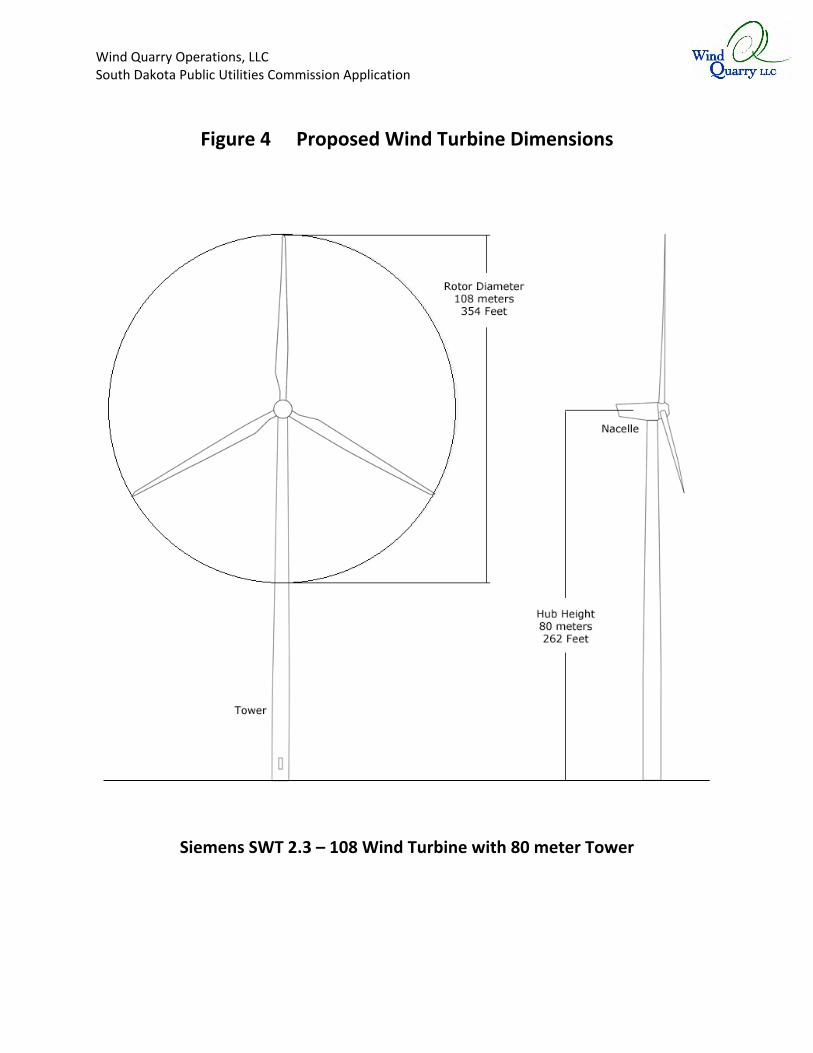
Wind Quarry Operations, LLC South Dakota Public Utilities Commission Application
Figure 4 Proposed Wind Turbine Dimensions
Siemens SWT 2.3 – 108 Wind Turbine with 80 meter Tower

Wind Quarry Operations, LLC South Dakota Public Utilities Commission Application
Figure 5 Typical Wind Turbine Foundation

Wind Quarry Operations, LLC South Dakota Public Utilities Commission Application
Figure 6 Typical Wind Turbine Crane Pad Layout
Example shows layout for 80 meter tower. Crane and component layout will be individually
designed for each turbine location.

lx--x--x--x--x
I x ®
I x
I ><
I x
I x
I x
I x
I x
I x
I x
I x
I x
I ®
x
I x
I ><
I 'o
I -~
x
L x-- x-- X -- x--
Wmd{j)____ ~LLC 1-)~
2 3 4
250'-o"
x--x--x--x--x--x--x--x--x--x--x--x--x--x--x
-~~ lt.\Tll
TIWll!:FOR~ER 2 11,/34,,kV
7Q/93.3/11 IU WW>.
Tff>.N5fORhlER 1 115/34.51:\1
7D(93.3/11 U WVA
-DlllClllPTIOll
®
PlllOJllCI'- PAT WALSHE
PlllOJllCl'Na.11111. 240774
5
x
I ><
I x
I x
I x
I x
I x
I x
I x
I x
I x
I x
b I
i;l
8
WIND QUARRY1 LLC
WILLOW CREEK WIND PROJECT BUTTE COUNTY, SD
7 8
GENERAL ARRANGEMENT 115KVl34:5K PROJECT SUBSTATION
PLAN VIEW
0 1" ?: PILlllMI~ I WCWGAD 1 D 1
~~111111;;;;;~i;;;;;;;;,llllllllllllllllllll~ ICAU! 1· = 15'-0" I llEET GA-01
D
c
B
A

Highway 212
Hig
hway
79
A
A'
Kp
Qal
Qal
Kp
QalKh
Kp
Kfh
Kfh
Qal
Qal
Qt
Kfh
Kp
Qal
Kp
Qt
Qt
Kfh
Copyright:© 2013 National Geographic Society, i-cubed
File Number:
Drawn By:Checked By:
150382
EF
AF
Public Utilities Permit Application
³0 1 2 3 40.5
Mi
LegendHighway
Project Boundary
Surficial GeologyQt: Terrace Deposits (Quaternary)
Qal: Alluvium (Quaternary)
Kh: Hell Creek Formation (Upper Cretaceous)
Kfh: Fox Hills Sandstone (Upper Cretaceous)
Kp: Pierre Shale (Upper Cretaceous)
Meade
Butte
Perkins
Dewey
CorsonHarding
Tripp
Todd
Day
Brown
Spink
Hand
Lyman
Ziebach
Pennington
Haakon
Custer
Shannon
Jackson
Sully
Stanley
Clark
Fall River
Faulk
Beadle
Mellette
Hyde
Jones
Brule
Bennett
Potter
Roberts
Gregory
Grant
Edmunds
Lake
Deuel
Aurora
Marshall
Hughes
Miner
McPherson
Charles Mix
Turner
Clay
Kingsbury
Campbell
Lincoln
Brookings
Walworth
Moody
Hamlin
Minnehaha
Hutchinson
JerauldBuffalo
Codington
McCook
Sanborn
Yankton
Douglas
Lawrence
Union
HansonDavison
Bon Homme
Project Area
Project Area
Figure 8a - Surficial Geology
Date:5/4/2015
Willow Creek Wind ProjectButte County, South Dakota
Geology of SD (2004) [downloaded file]. State of South Dakota. URL:http://arcgis.sd.gov/server/sdgis/Data.aspx [May 4, 2015]
Project Area Provided by Wind Quarry Operations, LLC
Contours and Hydrology downloaded from USGS National Map Viewer.
A A' Geologic Section (see Figure 1c)
FMG ENGINEERINGCIVIL-GEOTECHNICAL-SURVEYING-TESTING-ENVIRONMENTAL
3700 STURGIS ROAD, RAPID CITY, SD 57702WWW.FMGENGINEERING.COM (605)342-4105

LEGEND
Qal : ALLUVIUM
Kp : PIERRE SHALE
APPROXIMATELOCATION OFHIGHWAY 212
LEGEND
Qal : ALLUVIUM
Kp : PIERRE SHALE
APPROXIMATEA ILOCATION OFL OHIGHWAY 212H Y
HORIZONTAL SCALE: 1"=5000'VERTICAL SCALE: 1"=50'
Qal
APPROXIMATEGROUND SURFACE
Kp
A(NORTH)
A(SOUTH)
8b

Highway 212
Hig
hway
79
Copyright:© 2013 National Geographic Society, i-cubed
File Number:
Drawn By:
Checked By:
150382
EF
AF
Public Utilities Permit Application
³0 1 2 3 40.5
Mi
Soil Types
BmA (Bidman Loam, 0 to 2 percent slopes)
CgD (Cabbart-Scroggin loams, 6 to 25 percent slopes)
HlB (Hisle loam, 0 to 9 percent slopes)
HsB (Hisle-Slickspots complex, 0 to 6 percent slopes)
KlA (Kyle clay, 0 to 2 percent slopes)
KlB (Kyle clay, 2 to 6 percent slopes)
KuB (Kyle-Pierre clays, 0 to 6 percent slopes)
LcE (Lismas clay, 10 to 40 percent slopes)
LeD (Lismas-Pierre clays, 3 to 18 percent slopes)
Mn (McKenzie clay)
PrB (Pierre clay, 2 to 6 percent slopes)
PrD (Pierre clay, 6 to 20 percent slopes)
Sa (Sage-Slickspots complex, 0 to 15 percent slopes)
Sb (Sage silty clay loam, 0 to 3 percent slopes)
Sg (Shale land)
SlB (Slickspots-Wasa complex, 0 to 6 percent slopes)
Sr (Stetter clay)
Ss (Stetter clay, channeled)
St (Lismas clay, 12 to 45 percent slopes, stony)
SuA (Swanboy clay, 0 to 3 percent slopes)
Sv (Swanboy-Slickspots complex, 0 to 3 percent slopes)
ToB (Twotop clay, 0 to 9 percent slopes)
W (Water)
WaB (Wasa-Slickspots complex, 0 to 6 percent slopes)
WnB (Winler clay, 0 to 9 percent slopes)
Meade
Butte
Perkins
Dewey
CorsonHarding
Tripp
Todd
Day
Brown
Spink
Hand
Lyman
Ziebach
Pennington
Haakon
Custer
Shannon
Jackson
Sully
Stanley
Clark
Fall River
Faulk
Beadle
Mellette
Hyde
Jones
Brule
Bennett
Potter
Roberts
Gregory
Grant
Edmunds
Lake
Deuel
Aurora
Marshall
Hughes
Miner
McPherson
Charles Mix
Turner
Clay
Kingsbury
Campbell
Lincoln
Brookings
Walworth
Moody
Hamlin
Minnehaha
Hutchinson
JerauldBuffalo
Codington
McCook
Sanborn
Yankton
Douglas
Lawrence
Union
HansonDavison
Bon Homme
Project Area
Project Area
Figure 9 - Soil Types
Date:5/4/2015
Willow Creek Wind ProjectButte County, South Dakota
SSURGO Database (2003) [downloaded file]. Web Soil Survey. URL:http://websoilsurvey.nrcs.usda.gov/ [May 4, 2015]
Project Area Provided by Wind Quarry Operations, LLC
USA Topo Maps (2013) [map service]. ESRI on ArcGIS Online. URL:http://services.arcgisonline.com/arcgis/services/USA_Topo_Maps/MapServer [May 4, 2015]
Legend
Highway
Project Boundary
FMG ENGINEERINGCIVIL-GEOTECHNICAL-SURVEYING-TESTING-ENVIRONMENTAL
3700 STURGIS ROAD, RAPID CITY, SD 57702WWW.FMGENGINEERING.COM (605)342-4105

Ser
vice
La
yer
Cre
dits
:
!!!!!!!!!!!!!!!!!!!!!!!!!!!!!!!!!!!!!!!!!!!!!!!!!!!!!!!
!
!
!
!
!
!
!
!
!
!
!
!
!
!
!
!
!
!
!
!
!
!
!
!
!
!
!
!
!
!
!
!
!
!
!
!
!
!
!
!
!
!
!
!
!
!
!
!
!
!
!
!
!
!
!
!
!
!
!
!
!
!
!
!
!
!
!
!
!
!
!
!
!
!
!
!
!
!
!
!
!
!
!
!
!
!
!
!
!
!
!
!
!
!
!
!
!
!
!
!
!
!
!
!
!
!
!
!
!
!
!
!!
!!
!!
!!
!!
!!
!!
!!
!!
!!
!!
!!
!!
!!
!!
!!
!!
!!
!!
!!
!!
!!
!!
!!
!!
!!
!!
!!
!!
!!
!!
!!
!!
£¤212
Maur
ine to
Rap
id Ci
ty 11
5-kV
US-212
Old Hwy 212
Old Twilight
Red Owl
New
Twilig
ht
Station ElmCreek
South Sul phur Creek
Mud
Elm
Creek
South Double R Creek
Sulphur Creek
Eightmile Creek
Lonetree Creek
SandCree kButte Creek
Double R Creek
E lmCree k
WillowCreek
CO
PY
RIG
HT
© 2
015
BU
RN
S &
McD
ON
NE
LL E
NG
INE
ER
ING
CO
MP
AN
Y, I
NC
.
Source: ESRI Data 2013; Energy Velocity; USGS NHD Dataset; USFWS National Wetland Inventory; FEMA Issued: 5/20/2015
Pat
h: Z
:\Clie
nts
\ES
P\W
ind
Qu
arry
\840
46_W
illow
Cre
ek\S
tudi
es\G
eos
pat
ial\D
ata
File
s\A
rcD
ocs\
Fig
ure1
0_W
ater
Res
ourc
es.m
xd
jbel
l 5
/20/
2015
NORTH
0 8,0004,000
Feet
Figure 10Water ResourcesWind Quarry, LLC
Willow Creek ProjectButte County, SD
!
! ! Maurine to Rapid City 115-kV
Willow Creek Project Area
Named Streams with Flow Direction
Intermittent Streams
Freshwater Emergent Wetland
Other Wetland Type
Freshwater Pond
Lake
FEMA 100yr Floodplain
Ser
vice
La
yer
Cre
dits
:
!!!!!!!!!!!!!!!!!!!!!!!!!!!!!!!!!!!!!!!!!!!!!!!!!!!!!!!
!
!
!
!
!
!
!
!
!
!
!
!
!
!
!
!
!
!
!
!
!
!
!
!
!
!
!
!
!
!
!
!
!
!
!
!
!
!
!
!
!
!
!
!
!
!
!
!
!
!
!
!
!
!
!
!
!
!
!
!
!
!
!
!
!
!
!
!
!
!
!
!
!
!
!
!
!
!
!
!
!
!
!
!
!
!
!
!
!
!
!
!
!
!
!
!
!
!
!
!
!
!
!
!
!
!
!
!
!
!
!
!!
!!
!!
!!
!!
!!
!!
!!
!!
!!
!!
!!
!!
!!
!!
!!
!!
!!
!!
!!
!!
!!
!!
!!
!!
!!
!!
!!
!!
!!
!!
!!
!!
£¤212
Maur
ine to
Rap
id Ci
ty 11
5-kV
US-212
Old Hwy 212
Old Twilight
Red Owl
New
Twilig
ht
CO
PY
RIG
HT
© 2
015
BU
RN
S &
McD
ON
NE
LL E
NG
INE
ER
ING
CO
MP
AN
Y, I
NC
.
Source: ESRI Data 2013; Energy Velocity; NLCD Land Use Land Cover Issued: 5/20/2015
Pat
h: Z
:\Clie
nts
\ES
P\W
ind
Qu
arry
\840
46_W
illow
Cre
ek\S
tudi
es\G
eos
pat
ial\D
ata
File
s\A
rcD
ocs\
Fig
ure1
1_L
andC
over
Type
s.m
xd
jbel
l 5
/20
/201
5
NORTH
0 8,0004,000
Feet
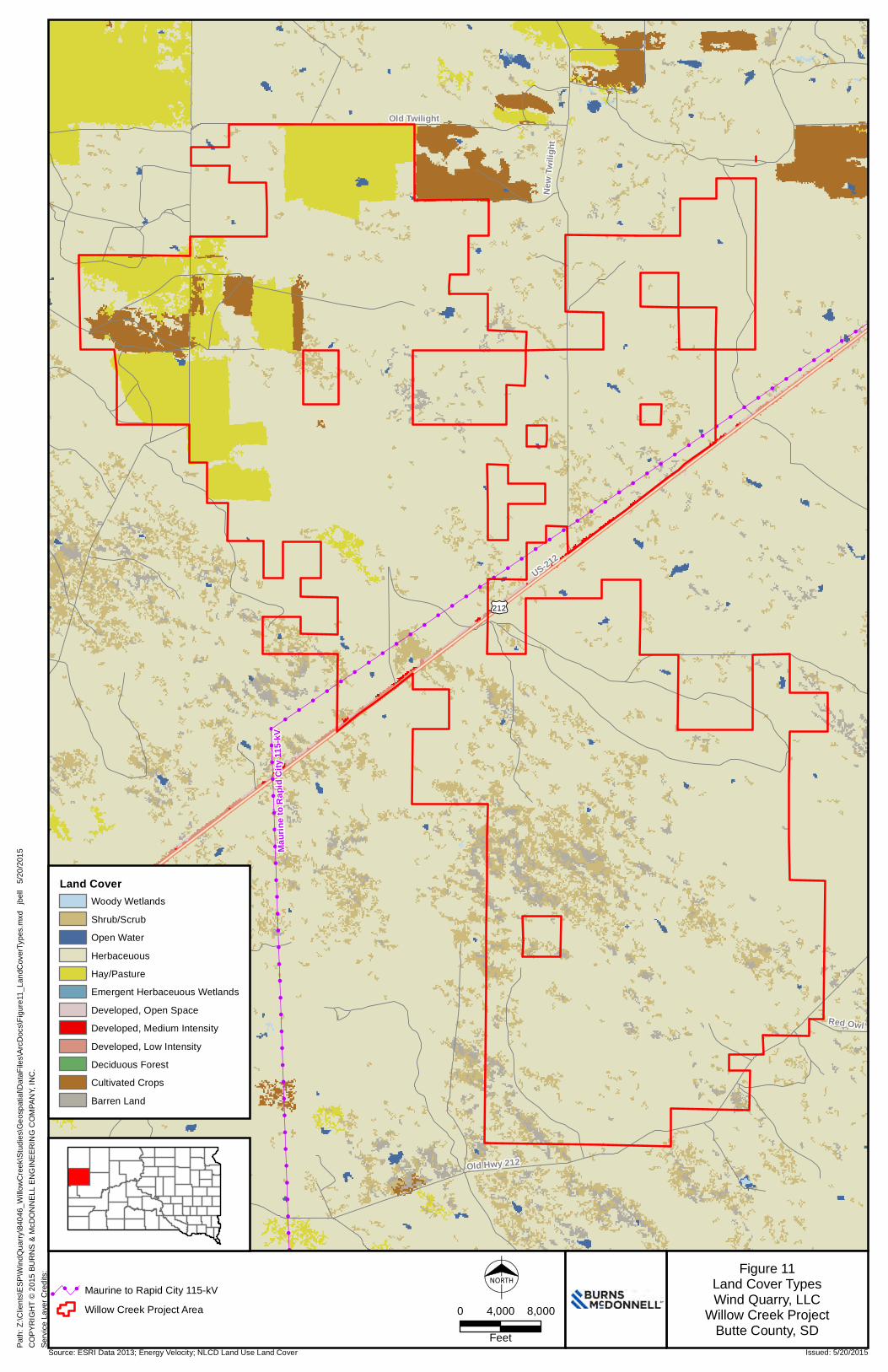
Figure 11Land Cover TypesWind Quarry, LLC
Willow Creek ProjectButte County, SD
!
!! Maurine to Rapid City 115-kV
Willow Creek Project Area
Land CoverWoody Wetlands
Shrub/Scrub
Open Water
Herbaceuous
Hay/Pasture
Emergent Herbaceuous Wetlands
Developed, Open Space
Developed, Medium Intensity
Developed, Low Intensity
Deciduous Forest
Cultivated Crops
Barren Land

Figure 12 – Most suitable areas for wind turbine placement based upon areas of lowest bald eagle and golden eagle suitability

Ser
vice
La
yer
Cre
dits
: Sou
rce
: Esr
i, D
igita
lGlo
be, G
eoE
ye,
Ear
thst
ar G
eogr
aphi
cs, C
NE
S/A
irbus
DS
, US
DA
, US
GS
, AE
X, G
etm
app
ing,
Ae
rogr
id, I
GN
, IG
P, s
wis
stop
o, a
nd th
e G
IS U
ser
Com
mun
ity
!!!!!!!!!!!!!!!!!!!!!!!!!!!!!!!!!!!!!!!!!!!!!!!!!!!!!!!
!
!
!
!
!
!
!
!
!
!
!
!
!
!
!
!
!
!
!
!
!
!
!
!
!
!
!
!
!
!
!
!
!
!
!
!
!
!
!
!
!
!
!
!
!
!
!
!
!
!
!
!
!
!
!
!
!
!
!
!
!
!
!
!
!
!
!
!
!
!
!
!
!
!
!
!
!
!
!
!
!
!
!
!
!
!
!
!
!
!
!
!
!
!
!
!
!
!
!
!
!
!
!
!
!
!
!
!
!
!
!
!!
!!
!!
!!
!!
!!
!!
!!
!!
!!
!!
!!
!!
!!
!!
!!
!!
!!
!!
!!
!!
!!
!!
!!
!!
!!
!!
!!
!!
!!
!!
!!
!!
"/
"/
"/"/
"/
£¤212
Maur
ine to
Rap
id Ci
ty 11
5-kV
US-212
Old Hwy 212
Old Twilight
Red Owl
New
Twilig
ht
CO
PY
RIG
HT
© 2
015
BU
RN
S &
McD
ON
NE
LL E
NG
INE
ER
ING
CO
MP
AN
Y, I
NC
.
Source: ESRI Data 2013; Energy Velocity; USGS PADUS GAP datat; BLM, State of South Dakota; SDGFP Issued: 5/20/2015
Pat
h: Z
:\Clie
nts
\ES
P\W
ind
Qu
arry
\840
46_W
illow
Cre
ek\S
tudi
es\G
eos
pat
ial\D
ata
File
s\A
rcD
ocs\
Fig
ure1
3_La
ndU
se_P
ublic
Lan
ds.m
xd
jbel
l 5
/20/
201
5
NORTH
0 8,0004,000
Feet
Figure 13Land Use and Public Lands
Wind Quarry, LLCWillow Creek Project
Butte County, SD
"/ Residences
!
!! Maurine to Rapid City 115-kV
Willow Creek Project Area
BLM Ownership Land
Bureau of Reclamation Land
South Dakota Public Land
Walk-In Hunting Areas

Ser
vice
La
yer
Cre
dits
: Sou
rce
: Esr
i, D
igita
lGlo
be, G
eoE
ye,
Ear
thst
ar G
eogr
aphi
cs, C
NE
S/A
irbus
DS
, US
DA
, US
GS
, AE
X, G
etm
app
ing,
Ae
rogr
id, I
GN
, IG
P, s
wis
stop
o, a
nd
the
GIS
Use
r C
omm
unity
Esr
i, H
ER
E,
DeL
orm
e, M
apm
yInd
ia, ©
Ope
nStr
eetM
ap c
ontr
ibut
ors
Esr
i, H
ER
E,
DeL
orm
e, T
omTo
m, M
apm
yInd
ia, ©
Ope
nS
tree
tMap
con
trib
utor
s, a
nd th
e G
IS u
ser
com
mun
ity
CO
PY
RIG
HT
© 2
015
BU
RN
S &
McD
ON
NE
LL E
NG
INE
ER
ING
CO
MP
AN
Y, I
NC
.
Source:Esri, DigitalGlobe, GeoEye, Earthstar Geographics, CNES/Airbus DS, USDA, USGS, AEX, Getmapping, Aerogrid, IGN, IGP, swisstopo, the GIS User Community and Burns & McDonnell Issued: 5/20/2015
Pat
h: Z
:\Clie
nts
\ES
P\W
ind
Qu
arry
\840
46_W
illow
Cre
ek\S
tudi
es\G
eos
pat
ial\D
ata
File
s\A
rcD
ocs\
Fig
ure1
4_P
red
icte
dSou
ndL
evel
Con
tour
s.m
xd
jbel
l 5
/20/
201
5
NORTH9,100 04,550
Scale in Feet
Figure 14Predicted Sound Level Contours
Wind Quarry, LLCWillow Creek Project
Butte County, SD
#
#
#
#
#
#
#
#
#
#
#
#
#
#
#
#
#
#
#
#
##
#
#
##
#
##
#
##
#
#
##
#
#
#
#
#
#
#
#
#
!.
!.
!.!.
!.
!. Receivers
# Wind Turbine Layout
Willow Creek Project Area
Sound Levels (dBA)303540
455055