appendix a: land protection plan conservation areas to benefit migratory birds and endangered...
TRANSCRIPT
Appendix A: Land Protection Plan
Hackmatack National Wildlife Refuge Environmental Assessment, Land Protection Plan, and Conceptual Management Plan 54
Appendix A: Land Protection Plan In this appendix A.1 Introduction and Purpose A.2 Project Description A.3 Refuge Purposes A.4 Land Acquisition Policy for Urban Refuges A.5 Status of Resources to be Protected A.6 Land Protection Priorities A.7 Land Conservation Options A.8 Land Conservation Methods A.9 Service Land Protection Policy A.10 Funding for Land Acquisition or Easement Purchase A.11 Socioeconomic and Cultural Impacts
A.1 Introduction and Purpose This Land Protection Plan (LPP) identifies the land conservation boundary for the proposed Hackmatack National Wildlife Refuge (NWR, Refuge). The U.S. Fish and Wildlife Service (FWS, Service), with input from the public, local governments, and numerous organizations, has delineated a region of biologically significant land in the Hackmatack Study Area. These acres are encompassed by the recommend acquisition boundary established in Alternative C: Cores and Corridors of the Environmental Assessment (EA) for the proposed Hackmatack NWR. The goal is to protect land throughout core sites and corridors through acquisition, conservation easements, partnerships with local governments, and the voluntary efforts of private landowners. The purposes of this LPP are to:
provide landowners and the public with an outline of Service policies, priorities, and protection methods for land in the project area,
assist landowners in determining whether their property lies within the proposed acquisition boundary, and
inform landowners about the long‐standing policy of acquiring land only from willing sellers. (The Service will not buy any lands or easements if the owners are not interested in selling.)
The LPP presents the methods the Service and interested landowners can use to accomplish their objectives for wildlife habitat within the Refuge boundary.
A.2 Project Description Early in 2010, the Service began to study the merits of establishing a refuge along the border of Wisconsin and Illinois. The proposed Hackmatack NWR was presented as a tool to connect the disparate dots of conserved land in southeast Wisconsin and northeast Illinois into a cohesive picture of landscape-level conservation. The concept is to create a new refuge that forms the nucleus of a regional conservation identity. A core conserved area owned and managed by the Service as a refuge would anchor this conservation initiative. Its far-reaching ecological and social impact would come from extensive

Appendix A: Land Protection Plan
Hackmatack National Wildlife Refuge Environmental Assessment, Land Protection Plan, and Conceptual Management Plan
55
partnerships with the many public and private landowners committed to furthering conservation in the region. The Service’s preferred alternative, Alternative C: Cores and Corridors, would link and expand upon existing conservation areas to benefit migratory birds and endangered species. The larger block sizes associated with the cores would provide sufficient habitat for nesting grassland birds and waterfowl that are sensitive to fragmented habitat and edges. The corridors would assist terrestrial migration of small mammals, herptiles, and plants that may be impacted by a changing climate. Land protection methods for the conservation core areas (11,193 acres) would include acquisition, conservation easement, and Non-Governmental Organizations (NGOs)/private opportunities aimed at creating contiguous natural habitat. The conservation corridors would connect the cores primarily through use of partnership efforts and to a lesser degree with land acquisition. Specific, narrow corridors can’t be identified at this time as detailed land status and partnerships would determine the ultimate siting. However, a continuous corridor of a minimum of 600 feet wide would be considered complete. Please see the EA for more details on the Refuge proposal.
A.3 Refuge Purposes The following purposes, identified from existing law, have been acknowledged for the establishment of the Refuge: “for any other management purpose, for migratory birds….” 16 U.S.C. §715d (Migratory Bird Conservation Act), and “the conservation of the wetlands of the Nation in order to maintain the public benefits they provide and to help fulfill international obligations contained in various migratory bird treaties and conventions ...” 16 U.S.C. §3901(b), 100 Stat. 3583 (Emergency Wetlands Resources Act of 1986), “for the development, advancement, management, conservation, and protection of fish and wildlife resources” 16 U.S.C. 742a et seq. (Fish and Wildlife Act of 1956). “and land, or interests therein, which are suitable for-- (1) incidental fish and wildlife-oriented recreational development, (2) the protection of natural resources,(3) the conservation of endangered species or threatened species listed by the Secretary pursuant to section 1533 of this title, or (4) carrying out two or more of the purposes set forth in paragraphs (1) through (3) of this section…” 16 U.S.C. §460(k), (Refuge Recreation Act, as amended).
A.3.1 Goals of Hackmatack NWR Goals for the proposed Hackmatack NWR were developed within the framework of the Refuge System’s mission statement, the Refuge Improvement Act, the Refuge’s primary purposes, and other Service policy and directives. The goals are intentionally broad statements that describe desired future conditions and guide the management of the Refuge in the interim period and the development of management objectives and strategies for the CCP. They are:
Protect and enhance habitats for federal trust species and species of management concern, with special emphasis on grassland-dependent migratory birds and protection of wetlands and grasslands.

Appendix A: Land Protection Plan
Hackmatack National Wildlife Refuge Environmental Assessment, Land Protection Plan, and Conceptual Management Plan 56
Create opportunities for hunting, fishing, wildlife observation and photography, and environmental education and interpretation, while promoting activities that complement the purposes of the Refuge and other protected lands in the region.
Promote science, education, and research through partnerships to inform land management decisions and encourage continued responsible stewardship of the natural resources of the Hackmatack NWR.
A.4 Land Acquisition Policy for Urban Refuges The Service seeks to provide Refuge visitors with an understanding and appreciation of fish and wildlife resources through environmental education and interpretation and through wildlife-oriented recreational experiences to the extent these activities are compatible with the purposes for which a Refuge is established.
1. The official Service land acquisition policy for urban Refuges is to acquire lands and waters in or adjacent to metropolitan statistical areas to protect fish and wildlife resources and habitats that will provide the public wildlife-oriented recreation, education, and interpretation opportunities.
2. Some urban Refuges may protect habitats of great significance to the conservation of fish and wildlife resources, including endangered and threatened species. However, the primary purpose for establishment of new urban Refuges will be to foster environmental awareness and outreach programs, and to develop an informed and involved citizenry that will support fish and wildlife conservation. If Service lands already exist in the same urban area, the Service will only acquire additional habitat types of sufficient size to meet habitat needs as determined by the Regions, as well as by education, interpretation, and recreation needs that are not currently being met by the existing Refuge or other state or county agencies. These Refuges will provide public use benefits associated with fish and wildlife resources that include, but are not limited to, bird watching, fishing, scientific research, environmental education, open space in an urban setting, and protection of cultural resources.
Management, operational, and acquisition considerations for urban Refuges will include:
a. Education, interpretation, and wildlife-oriented recreation value;
b. Opportunities for partnerships with state and local governments, private individuals, or citizens groups;
c. Potential role of non-profit or volunteer groups for management purposes;
d. Adequacy of buffer areas and habitat corridors where possible that contribute appreciably to the long-term preservation of habitats.
A.5 Status of Resources to be Protected
A.5.1 Wildlife and Habitat Resources Two habitat types account for most of the sensitive species in the Study Area: wetlands and grasslands. Historically, as much as 22 percent of the Study Area may have been wetland while 21 percent may have been grassland; an additional five percent may have been savanna. The remainder of the landscape was most likely forest and mixed forest/prairie. The glacial history of the Study Area produced a rich variety
Appendix A: Land Protection Plan
Hackmatack National Wildlife Refuge Environmental Assessment, Land Protection Plan, and Conceptual Management Plan
57
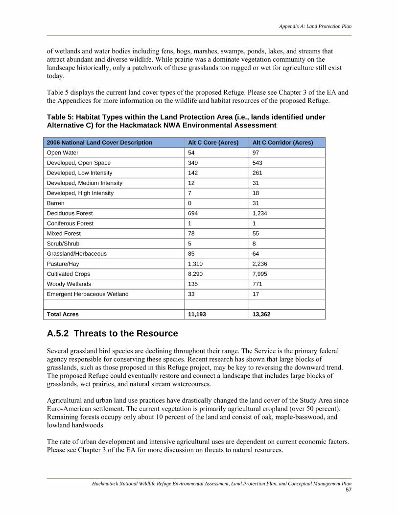
of wetlands and water bodies including fens, bogs, marshes, swamps, ponds, lakes, and streams that attract abundant and diverse wildlife. While prairie was a dominate vegetation community on the landscape historically, only a patchwork of these grasslands too rugged or wet for agriculture still exist today. Table 5 displays the current land cover types of the proposed Refuge. Please see Chapter 3 of the EA and the Appendices for more information on the wildlife and habitat resources of the proposed Refuge. Table 5: Habitat Types within the Land Protection Area (i.e., lands identified under Alternative C) for the Hackmatack NWA Environmental Assessment 2006 National Land Cover Description Alt C Core (Acres) Alt C Corridor (Acres)
Open Water 54 97
Developed, Open Space 349 543
Developed, Low Intensity 142 261
Developed, Medium Intensity 12 31
Developed, High Intensity 7 18
Barren 0 31
Deciduous Forest 694 1,234
Coniferous Forest 1 1
Mixed Forest 78 55
Scrub/Shrub 5 8
Grassland/Herbaceous 85 64
Pasture/Hay 1,310 2,236
Cultivated Crops 8,290 7,995
Woody Wetlands 135 771
Emergent Herbaceous Wetland 33 17
Total Acres 11,193 13,362
A.5.2 Threats to the Resource Several grassland bird species are declining throughout their range. The Service is the primary federal agency responsible for conserving these species. Recent research has shown that large blocks of grasslands, such as those proposed in this Refuge project, may be key to reversing the downward trend. The proposed Refuge could eventually restore and connect a landscape that includes large blocks of grasslands, wet prairies, and natural stream watercourses. Agricultural and urban land use practices have drastically changed the land cover of the Study Area since Euro-American settlement. The current vegetation is primarily agricultural cropland (over 50 percent). Remaining forests occupy only about 10 percent of the land and consist of oak, maple-basswood, and lowland hardwoods. The rate of urban development and intensive agricultural uses are dependent on current economic factors. Please see Chapter 3 of the EA for more discussion on threats to natural resources.

Appendix A: Land Protection Plan
Hackmatack National Wildlife Refuge Environmental Assessment, Land Protection Plan, and Conceptual Management Plan 58
A.5.3 Continuing Partnership Effort The threats to the resource described above make preserving land in the proposed Refuge both crucial and challenging. As real estate values increase due to the influx of people from the Chicago metropolitan area, the need to act quickly to preserve key parcels remaining in McHenry County becomes more apparent. For that reason, the Service recognizes the need to collaborate with other conservation organizations in the region. Therefore, the Refuge would work to combine efforts with those of many partners. These partners use their individual mission statements to focus protection and restoration efforts. Taken together, those mission statements cover the protection of farmland, threatened and endangered species, scenic areas, grassland habitats, and open space that the local community has identified as significant.
A.6 Land Protection Priorities All of the lands included in the preferred action area have significant resource values and high potential for ensuring habitat connectivity between the Refuge and surrounding conservation lands. In general, the availability of land from willing sellers and the availability of funding at that time will influence the actual order of land protection. However, as landowners offer parcels, and as funds become available, Refuge managers will base the priority for land protection on several factors. Priority is assigned as follows: Priority 1 (Core Areas): Priority 1 parcels contain most of the lands and habitats that meet the threshold for federal protection. They are:
parcels that contain a significant amount of functioning undisturbed or relatively undisturbed grasslands, oak savanna, or wetlands of significant importance that support federal trust species (e.g., federally‐listed species, migratory birds);
parcels that contain potentially significant habitat for federally‐listed species found within the Refuge acquisition boundary;
parcels that are of significant importance to the Fox River or Nippersink watersheds;
parcels that have a significant value for migratory birds, with prime nesting and foraging habitats for federal‐or state‐listed species; and/or
parcels that help to restore or maintain habitat connectivity.
Priority 2 (Corridors): Priority 2 parcels are all those that contribute to making connection corridors between core units and existing conservation lands. Within the corridors a higher protection priority will be given to:
riparian corridors or wetlands associated with or hydrologically connected to core units;
parcels that contribute to recreational trails; and
disturbed grasslands or wetlands that can be easily restored.
Corridor Selection Criteria and Desirable Features The following selection criteria will be used to develop the best possible routes for future connecting habitat corridors.
Appendix A: Land Protection Plan
Hackmatack National Wildlife Refuge Environmental Assessment, Land Protection Plan, and Conceptual Management Plan
59
No development.
Native habitats.
Wide enough for wildlife corridor as well as room for a multi-use trail; minimum 600 feet wide; assume average of 660 feet (1/8 mile; 80 acres/mile).
Shortest possible route between core areas when the property can meet other criteria.
Willing participant landowners only.
Use existing corridors when possible.
Avoid roads when possible.
The corridors have permanent protection.
Avoid high economic value land when possible.
Corridors contain areas of woody vegetation as well as grassland to facilitate movement of animals and plants dependent upon both habitat types.
Trails are located on corridor edges, not through the center, to avoid habitat fragmentation.
Possible means to create the corridors:
Partners take the lead in developing the corridors.
If Service is involved in acquiring the corridors.
Partner acquires rights to any areas to be used by snowmobiles prior to Service acquisition of any rights; Service works with partners to minimize any potential negative impacts of the trail’s location.
Easements are first priority; include rights to establish a multi-use trail.
Voluntary partnerships with landowners are possible but may not result in areas that allow trail development.
Use willing-seller acquisition as the last resort.
Service or partners obtain rights to restore habitats in the corridor or at least maintain existing habitats where they are compatible with Service interests.
See Figure 10 (below) for a map depicting land protection priorities for the proposed Hackmatack NWR.

Appendix A: Land Protection Plan
Hackmatack National Wildlife Refuge Environmental Assessment, Land Protection Plan, and Conceptual Management Plan 60
Figure 10: Land Protection Priorities for the Proposed Hackmatack NWR (USFWS, 2011)

Appendix A: Land Protection Plan
Hackmatack National Wildlife Refuge Environmental Assessment, Land Protection Plan, and Conceptual Management Plan
61
The Service intends to minimize the need to acquire residences and buildings on these lands, while protecting and restoring habitat, so parcels of this nature will be evaluated on a case‐by‐case basis. The Service reserves the right to be flexible with the detailed priority list, because a number of factors also influence the priority of land protection, including the availability of willing sellers and the availability of funding. In addition, the Service must be flexible in its methods and priorities of land protection to meet the needs of individual landowners. Service policy in acquiring land is to acquire only the minimum interest necessary to meet refuge goals and objectives and acquire it only from willing sellers.
A.7 Land Conservation Options The following options will be used to implement this LPP. Option 1. Management or Land Conservation by Others A great deal of land in, adjacent to, and ecologically important to the proposed Hackmatack NWR is already owned or managed by conservation partners. It should also be emphasized that the protection of the Hackmatack NWR fits well into a large landscape scale wildlife and habitat corridor that is being pieced together in the area. Hackmatack NWR would serve as an important keystone in this conservation effort. The following partners both manage easements or own properties that are ecologically associated with the proposed Refuge:
McHenry County Conservation District
Illinois Department of Natural Resources
Wisconsin Department of Natural Resources
Illinois Nature Preserves Commission
The Land Conservancy of McHenry County
Several Local Land Trusts
Option 2. Less‐than‐full Acquisition Under option 2, the Refuge will protect and manage land by purchasing only a partial interest, typically in the form of a conservation easement. This option leaves the parcel in private ownership, while allowing control over the land use in a way that enables the Refuge to meet the goals for the parcel or that provides adequate protection for important adjoining parcels and habitats. The structure of such easements will provide permanent protection of existing wildlife habitats while also allowing habitat management or improvements and access to sensitive habitats, such as for endangered species or migratory birds. It will also allow for public use where appropriate. The Refuge Manager will determine, on a case‐by‐case basis, and negotiate with each landowner, the extent of the rights to be purchased. Those may vary, depending on the configuration and location of the parcel, the current extent of development, the nature of wildlife activities in the immediate vicinity, the needs of the landowner, and other considerations. In general, any less‐than‐fee acquisition will maintain the land in its current configuration with no further subdivision. Easements are a property right and typically are perpetual. If a landowner later sells the property, the easement continues as part of the title. Properties subject to easements generally remain on the tax rolls, although the change in market value may reduce the assessment. The Service does not pay

Appendix A: Land Protection Plan
Hackmatack National Wildlife Refuge Environmental Assessment, Land Protection Plan, and Conceptual Management Plan 62
refuge revenue sharing on easement rights. Where conservation easements are identified, the Service will be interested primarily in purchasing development and some wildlife management rights. Easements are best when only minimal management of the resource is needed, but there is a desire to ensure the continuation of current undeveloped uses and to prevent fragmentation over the long‐term and in places where the management objective is to allow vegetative succession, such as when:
a landowner is interested in maintaining ownership of the land, does not want it to be further developed, and would like to realize the benefits of selling development rights;
current land use regulations limit the potential for adverse management practices;
the protection strategy calls for the creation and maintenance of a watershed protection area that can be accommodated with passive management; or
only a portion of the parcel contains lands of interest to the Service.
The determination of value for purchasing a conservation easement involves an appraisal of the rights to be purchased, based on recent market conditions and structure in the area. The Land Protection Methods section further describes the conditions and structure of easements. Option 3. Land Acquisition Under option 3, the Service will acquire parcels in full title from willing sellers, thereby purchasing all rights of ownership. This option provides the most flexibility in managing priority lands and ensuring the protection in perpetuity of nationally significant trust resources. Generally, the lands acquired will require more than passive management (e.g., controlling invasive species, mowing or prescribed burning, planting, or managing for the six priority public uses). The Service only proposes full acquisition when adequate land protection is not assured under other ownerships, active land management is required, or when the current landowner would be unwilling to sell a partial interest like a conservation easement. In some cases, it may become necessary to convert a previously acquired conservation easement to full acquisition: for example, when an owner is interested in selling the remainder of interest in the land. These requests will be evaluated on a case‐by‐case basis.
A.8 Land Conservation Methods Three methods of acquiring either a full or a partial interest in the parcels identified for Service land protection are detailed below. They are: (1) purchase (e.g., complete title, or a partial interest like a conservation easement), (2) donation, and (3) exchange. Purchase: For most of the tracts in the boundary, the proposed method is listed as Acquisition or Easement; however, the method ultimately used depends partly on the landowner’s wishes. Purchase involves buying the parcel of land outright from a willing seller with full title (all rights, complete ownership), as the availability of funding allows. Easement purchase refers to the purchase of limited rights (less than full) from an interested landowner. The landowner would retain ownership of the land, but would sell certain rights identified and agreed upon by both parties. The objectives and conditions of proposed conservation easements would recognize

Appendix A: Land Protection Plan
Hackmatack National Wildlife Refuge Environmental Assessment, Land Protection Plan, and Conceptual Management Plan
63
lands for their importance to wildlife habitat or outdoor recreational activities and any other qualities that recommend them for addition to the Refuge System. Donation: Donations with full title or conservation easement in the approved areas will be encouraged and welcomed. The planning team is not aware currently of any formal opportunities to accept donations of parcels in the land protection boundary. Exchange: The Service has the authority to exchange land in Service ownership for other land that has greater habitat or wildlife value. Inherent in this concept is the requirement to get dollar‐for‐dollar value with, occasionally, an equalization payment. Exchanges are attractive, because they usually do not increase federal land holdings or require purchase funds; however, they also may be very labor‐intensive and take a long time to complete.
A.9 Service Land Protection Policy Once a refuge land protection boundary has been approved, the refuge manager may contact neighboring landowners to determine whether any are interested in selling. If a landowner expresses an interest and gives permission, a real estate appraiser will appraise the property to determine its market value. Once an appraisal has been approved, an offer can be presented for the landowner’s consideration. The Service’s long‐established policy is to work with willing sellers as funds become available. Appraisals conducted by Service or contract appraisers must meet federal as well as professional appraisal standards. Federal law requires the Service to purchase properties at their market value, which typically is based on comparable sales of similar types of properties. The planning team based the land protection boundary on the biological importance of key habitats. That gives the Service the approval to negotiate with landowners that may be interested or may become interested in selling their land in the future. With those internal approvals in place, the Service can react more quickly as important lands become available. Lands in that boundary do not become part of the refuge unless their owners sell or donate them to the Service. A landowner may choose to sell land to the Service and retain the right to occupy an existing residence. That is a “life use reservation.” It applies during the seller‘s lifetime but can also apply for a specific number of years. A discount from the appraised value of the buildings and land will be applied to cover the “rent” or use reservation. The occupant would be responsible for the upkeep on the reserved premises. The refuge would own the land, and pay revenue sharing to the appropriate taxing authority. In rare circumstances, at the request of a seller, the Service can use “friendly condemnation” to help determine value or to obtain clear title to the land. Although the Service has a long‐standing policy of acquiring land only from willing sellers, it also has the power of eminent domain, as do other federal, state, and local government agencies. A friendly condemnation proceeding can be used when the Service and a seller cannot agree on property value, and both agree to allow a court to determine fair market value. When a title company cannot determine the rightful owner of a property, friendly condemnation can be used to clear title. The Service does not expect to use friendly condemnation very often, if at all. The Service would not use condemnation otherwise, as it counters good working relations with the public.
A.10 Funding for Land Acquisition or Easement Purchase Funding to buy land comes primarily from the Land and Water Conservation Fund (LWCF), which derives from certain user fees, the proceeds from the disposal of surplus federal property, the federal tax

Appendix A: Land Protection Plan
Hackmatack National Wildlife Refuge Environmental Assessment, Land Protection Plan, and Conceptual Management Plan 64
on motor boat fuels, and oil and gas lease revenues. About 90 percent of that fund now derives from Outer Continental Shelf oil and gas leases. The federal government receives about 40 percent of that fund to acquire and develop nationally significant conservation lands. Another source of funding to purchase land is the Migratory Bird Conservation Fund (MBCF), which derives from Federal Duck Stamp revenue. The planning team recommends using both funds to buy either full or partial interests in lands in the project area. The Service will use LWCF funds to acquire land and easements that consist mainly of upland grasslands or forests. A request for MBCF funds would be appropriate for properties that include emergent wetlands and waters important for waterfowl. Another potential source for funding in that category is the North American Wetlands Conservation Fund.
A.11 Socioeconomic and Cultural Impacts No significant adverse socioeconomic or cultural impacts are expected due to the refuge proposal. A net positive benefit is expected to result for the local community. Towns will benefit from increased refuge revenue sharing payments and lower potential costs from these parcels, savings on the cost of community services, increased property values, increased watershed protection, maintenance of scenic values, and increased revenues for local businesses from refuge visitors who participate in bird watching, hunting, and wildlife observation. During public involvement for the study, most local residents and town officials were enthusiastic about Service land protection. Many people encouraged the planning team to develop a larger proposal. Land protection by the Service, while aimed at protecting trust resources, watersheds, and other natural resource values, would also maintain the rural character of the area. Please see the EA for more information on socioeconomic and cultural impacts.