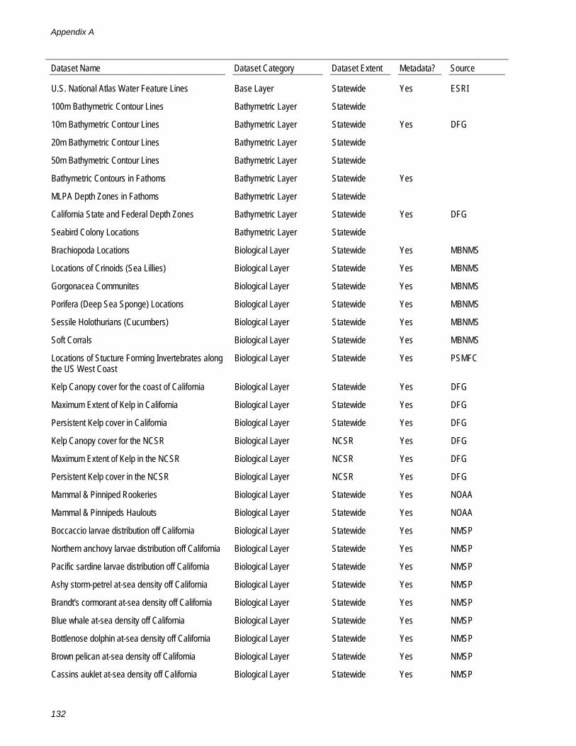
appendix a: spatial data layers available · appendix a: spatial data layers available table a-1...
TRANSCRIPT

Appendix A: Spatial Data Layers Available
Table A-1 lists the spatial data layers currently available for use in designing marine protected areas for the north coast study region.
The following acronyms are used in Table A-1:
BLM U.S. Bureau Of Land Management CSP California State Parks DFG California Department of Fish & Game ESI Environmental Sensitivity Index ESRI Environmental Systems Research Institute FERC Federal Energy Regulatory Commission GNIS Geographic Names Information System MBNMS Monterey Bay National Marine Sanctuary MMS U.S. Minerals Management Service NMSP National Marine Sanctuary Program NOAA National Oceanic & Atmospheric Administration PCGFMP Pacific Coast Groundfish Fishery Management Plan PSMFC Pacific States Marine Fisheries Commission SWRCB State Water Resources Control Board TNC The Nature Conservancy UCSB University of California Santa Barbara US Census U.S. Census Bureau USCD United States Department of Commerce USFWS United States Fish & Wildlife Service USGS United States Geological Survey
Table A-1: Spatial data layers
Dataset Name Dataset Category Dataset Extent Metadata? Source
Buoys of California Base Layer Statewide Yes
California State Boundary Base Layer Statewide Yes DFG
California Coast Polyline Base Layer Statewide Yes DFG
Geographic Place Names Base Layer Statewide Yes GNIS
1 Minute Graticule for the MLPA Study Region Base Layer Statewide Yes UCSB
5 Minute Graticule for the MLPA Study Region Base Layer Statewide Yes UCSB
10 Minute Graticule for the MLPA Study Region Base Layer Statewide Yes UCSB
California Islands Base Layer Statewide Yes DFG
Roads for California Base Layer Statewide Yes US Census
Shoreline Features (Coastal Status) Base Layer Statewide
California MLPA Study Regions Base Layer Statewide Yes DFG
State Highways near NCSR Base Layer NCSR Yes DFG
Appendix A
132
Dataset Name Dataset Category Dataset Extent Metadata? Source
U.S. National Atlas Water Feature Lines Base Layer Statewide Yes ESRI
100m Bathymetric Contour Lines Bathymetric Layer Statewide
10m Bathymetric Contour Lines Bathymetric Layer Statewide Yes DFG
20m Bathymetric Contour Lines Bathymetric Layer Statewide
50m Bathymetric Contour Lines Bathymetric Layer Statewide
Bathymetric Contours in Fathoms Bathymetric Layer Statewide Yes
MLPA Depth Zones in Fathoms Bathymetric Layer Statewide
California State and Federal Depth Zones Bathymetric Layer Statewide Yes DFG
Seabird Colony Locations Bathymetric Layer Statewide
Brachiopoda Locations Biological Layer Statewide Yes MBNMS
Locations of Crinoids (Sea Lillies) Biological Layer Statewide Yes MBNMS
Gorgonacea Communites Biological Layer Statewide Yes MBNMS
Porifera (Deep Sea Sponge) Locations Biological Layer Statewide Yes MBNMS
Sessile Holothurians (Cucumbers) Biological Layer Statewide Yes MBNMS
Soft Corrals Biological Layer Statewide Yes MBNMS
Locations of Stucture Forming Invertebrates along the US West Coast
Biological Layer Statewide Yes PSMFC
Kelp Canopy cover for the coast of California Biological Layer Statewide Yes DFG
Maximum Extent of Kelp in California Biological Layer Statewide Yes DFG
Persistent Kelp cover in California Biological Layer Statewide Yes DFG
Kelp Canopy cover for the NCSR Biological Layer NCSR Yes DFG
Maximum Extent of Kelp in the NCSR Biological Layer NCSR Yes DFG
Persistent Kelp cover in the NCSR Biological Layer NCSR Yes DFG
Mammal & Pinniped Rookeries Biological Layer Statewide Yes NOAA
Mammal & Pinnipeds Haulouts Biological Layer Statewide Yes NOAA
Boccaccio larvae distribution off California Biological Layer Statewide Yes NMSP
Northern anchovy larvae distribution off California Biological Layer Statewide Yes NMSP
Pacific sardine larvae distribution off California Biological Layer Statewide Yes NMSP
Ashy storm-petrel at-sea density off California Biological Layer Statewide Yes NMSP
Brandt's cormorant at-sea density off California Biological Layer Statewide Yes NMSP
Blue whale at-sea density off California Biological Layer Statewide Yes NMSP
Bottlenose dolphin at-sea density off California Biological Layer Statewide Yes NMSP
Brown pelican at-sea density off California Biological Layer Statewide Yes NMSP
Cassins auklet at-sea density off California Biological Layer Statewide Yes NMSP

Spatial Data Layers Available
133
Dataset Name Dataset Category Dataset Extent Metadata? Source
Common dolphin at-sea density off California Biological Layer Statewide Yes NMSP
Dall's porpoise at-sea density off California Biological Layer Statewide Yes NMSP
Double-crested cormorant at-sea density off California
Biological Layer Statewide Yes NMSP
Fin whale at-sea density off California Biological Layer Statewide Yes NMSP
Gray whale at-sea density off California Biological Layer Statewide Yes NMSP
Harbor porpoise at-sea density off California Biological Layer Statewide Yes NMSP
Humpback whale at-sea density off California Biological Layer Statewide Yes NMSP
Minke whale at-sea density off California Biological Layer Statewide Yes NMSP
Northern right-whale dolphin at-sea density off California
Biological Layer Statewide Yes NMSP
Killer whale at-sea density off California Biological Layer Statewide Yes NMSP
Pelagic cormorant at-sea density off California Biological Layer Statewide Yes NMSP
Pigeon guillemot at-sea density off California Biological Layer Statewide Yes NMSP
Pacific white-sided dolphin at-sea density off California
Biological Layer Statewide Yes NMSP
Risso's dolphin at-sea density off California Biological Layer Statewide Yes NMSP
Xantus's murrelet at-sea density off California Biological Layer Statewide Yes NMSP
Composite fish diversity off southern California Biological Layer Statewide Yes NMSP
Marbled Murrelet Proposed Critical Habitat (MAMU_PCH2006)
Biological Layer NCSR Yes USFWS
Salmonid Sea Outlets Biological Layer NCSR Yes TNC
Seabird Colony Locations Biological Layer NCSR Yes USFWS
Proposed Critical habitat for Tidewater Goby (Eucyclogobius newberryi)
Biological Layer NCSR Yes USFWS
Commercial Passenger Fishing Vessel (CPFV) landings
Consumptive Use Layer Statewide
California Recreational Fisheries Survey's (CRFS) sampled Commercial Passenger Fishing Vessel (CPFV) landings by 1' block for 2004, 2005, and 2006
Consumptive Use Layer Statewide Yes DFG
California Recreational Fisheries Survey's (CRFS) sampled Skiff Effort by 1' block for 2004 and 2005
Consumptive Use Layer Statewide Yes DFG
Spot Prawn Trap Data for California Consumptive Use Layer Statewide Yes DFG
Spot Prawn Trawl Logs Consumptive Use Layer Statewide Yes DFG
Cites of California Cultural Layer Statewide Yes DFG
Coastal Access Points Cultural Layer Statewide Yes DFG
Geographic Points of the California Coast Cultural Layer Statewide Yes DFG

Appendix A
134
Dataset Name Dataset Category Dataset Extent Metadata? Source
California Counties Cultural Layer Statewide Yes DFG
Harbors of California Cultural Layer Statewide Yes USGS
Ocean outfalls Cultural Layer Statewide Yes SWRCB
Marine Ports of California Cultural Layer Statewide Yes DFG
Marine Research Institutions of California Cultural Layer Statewide Yes UCSB
Environmental Sensitivity Index Map for Central and Northern California Shoreline
Cultural Layer Statewide Yes ESI
Telecommunication Cables Cultural Layer Statewide
Urban Areas of California from Census of 2000 Cultural Layer Statewide Yes US Census
Applications for FERC for Hydrokinetic Projects off the CA coast
Cultural Layer Statewide Yes FERC
Coastal Marine Ports of California (NCSR only) Cultural Layer NCSR Yes DFG
Marine Research Institutions of California (NCSR only)
Cultural Layer NCSR Yes DFG
Shore Dive Locations Cultural Layer NCSR Yes
Shipwrecks of the United States Cultural Layer Statewide NOAA
Coastal Marsh Locations Habitat Layer Statewide Yes NOAA
California Eelgrass Habitat Layer Statewide Yes DFG
California Estuaries Habitat Layer Statewide Yes TNC
Coarse Scale Hard and Soft Bottom Habitats Habitat Layer Statewide Yes PSMFC
Seagrass distribution off California Habitat Layer Statewide Yes PSMFC
Sensitivity of Coastal Environments and Wildlife to Spilled Oil
Habitat Layer Statewide Yes ESI
Surf Grass Along the California Coast Habitat Layer Statewide Yes MMS
California Trawl Logbook Management Layer Statewide Yes PSMFC
California Areas of Special Concern Management Layer Statewide
Critical Coastal Areas Management Layer Statewide Yes NOAA
California Department of Fish and Game Districts (DFG Districts)
Management Layer Statewide Yes DFG
Dump sites as depicted on 200k NOAA charts Management Layer Statewide Yes NOAA
Exclusive Economic Zone for California Management Layer Statewide Yes NOAA
Essential Fish Habitat (EFH) off Washington, Oregon, and California for NMFS' Final Rule Implementing Amendment 19 to the Pacific Coast Groundfish Fishery Management Plan
Management Layer Statewide Yes PCGFMP

Spatial Data Layers Available
135
Dataset Name Dataset Category Dataset Extent Metadata? Source
The area seaward of the 700-fathom Depth Contour off Washington, Oregon, and California for NMFS' Final Rule Implementing Amendment 19 to the Pacific Coast Groundfish Fishery Management Plan
Management Layer Statewide Yes PCGFMP
California Coastal National Monument Management Layer Statewide Yes BLM
2004 Federal Marine Protected Areas Management Layer Statewide Yes DFG
Impaired Rivers Management Layer Statewide Yes SWRCB
Impaired Water Bodies Management Layer Statewide Yes SWRCB
California Administrative Kelp Bed Boundaries Management Layer Statewide Yes DFG
Terrestrial Managed Areas Management Layer Statewide Yes BLM
1 Minute MicroBlocks Management Layer Statewide Yes DFG
Overlapping areas of RCA's and recreational bottom fishing regulations showing areas prohibited from fishing at all times. This layer does not include CowCod Conservation Areas.
Management Layer Statewide Yes DFG
2007 Rockfish Conservation Area (RCA) Contour Lines
Management Layer Statewide Yes NOAA
California Non-Groundfish Rockfish Conservation Area (RCA) for 2009 - 2010
Management Layer Statewide Yes DFG
2005 Non Trawl Rockfish Conservation Area within California State Jurisdictional Water
Management Layer Statewide Yes NMFS
2007 Rockfish Conservation Areas (RCA) - Non Trawl
Management Layer Statewide Yes NOAA
2007 Rockfish Conservation Areas (RCA) - Non trawl (persistent closure)
Management Layer Statewide Yes NOAA
California Non-Trawl Rockfish Conservation Area (RCA) for 2009 - 2010
Management Layer Statewide Yes DFG
2005 California Recreational Groundfish Full-Time Closures for California
Management Layer Statewide Yes DFG
2007 Rockfish Conservation Areas (RCA) - Recreational (persistent closure)
Management Layer Statewide Yes NOAA
2007 Rockfish Conservation Areas (RCA) - Recreational
Management Layer Statewide Yes NOAA
California Recreational Rockfish Conservation Area (RCA) for 2009 - 2010
Management Layer Statewide Yes DFG
2005 Trawl Rockfish Conservation Area within California State Jurisdictional Water
Management Layer Statewide Yes NMFS
2007 Rockfish Conservation Areas (RCA) - Trawl Management Layer Statewide Yes NOAA
California Trawl Rockfish Conservation Area (RCA) for 2009 - 2010
Management Layer Statewide Yes DFG

Appendix A
136
Dataset Name Dataset Category Dataset Extent Metadata? Source
2007 Rockfish Conservation Areas (RCA) - Trawl (persistent closure)
Management Layer Statewide Yes NOAA
Restricted Areas Management Layer Statewide Yes DFG
California State Underwater Parks Management Layer Statewide Yes CSP
California State Park Lands Management Layer Statewide
California State Waters Line Management Layer Statewide Yes NOAA
State Water Quality Protection Areas 2003 Management Layer Statewide Yes DFG
Existing Marine Protected Areas in California MPA Layer Statewide Yes DFG
Marine Managed Areas of the United States: State of California Digital Boundaries
MPA Layer Statewide Yes USCD
Beach Nourishment Sites Physical Layer Statewide
Nearshore Canyon Heads of California Physical Layer Statewide Yes PSMFC
Coastal Rivers Physical Layer Statewide
Coastal Hydrography of California Physical Layer Statewide Yes DFG
Bathymetric DEM, 200 Meter Resolution (Depth Values in Meters)
Bathymetric Layer Statewide Yes DFG
200m Bathymetric Hillshade in color Bathymetric Layer Statewide
200m Bathymetric Hillshade in gray Bathymetric Layer Statewide
At sea bird diversity Biological Layer Statewide Yes NOAA
200k Noaa Color Chart Chart Layer Statewide NOAA
NOAA Chart San Diego to Mendicino Chart Layer Statewide
Terrestrial Hillshade 30m in Color Physical Layer Statewide
DEM from NOAA BioGeo Assessment Physical Layer Statewide NOAA
Ocean Currents Data 1997-99 Physical Layer Statewide NOAA
SST Data from Noaa BioGeo Assessment 1993-2003
Physical Layer Statewide NOAA

Appendix B: Profile of Commercial Fisheries
B.1 Summaries of Commercial Fisheries by County
Table B-1 defines the market category groupings for finfish and invertebrates fished commercially in the north coast study region, and tells what gear is primarily used in fishing for each market category. The other tables in this section show, on a county-by-county basis, the numbers of fishermen and vessels actively fishing each category in 2008, and the average annual landings and ex-vessel revenue for each category in the ten years ending in 2008.
Table B-1: Market category groupings and primary gear
Market category Groupings Primary Species Targeted Primary Gear
Finfish
Deeper nearshore Black, brown, olive, copper, treefish, blue and quillback rockfishes
Hook and line
Hagfish Hagfish Trap
Lingcod Lingcod Hook and line
Salmon4 Chinook salmon Troll hook-and line and mooching
Shallow nearshore Kelp greenling, cabezon, scorpionfish, monkeyface eel and the following rockfish: black-and-yellow, China, gopher, kelp, and grass
Hook and line
Skates/Rays/Sharks All sharks and rays except white shark and big skate Hook and line
Smelt Jacksmelt, topsmelt, and true, surf and night smelt. Hook and line
Surfperch Redtail surfperch Hook and line
Invertebrates
Coonstripe shrimp Coonstripe shrimp Trap
Dungeness crab Dungeness crab Circular traps
Urchin Red urchin Hand harvest with scuba or hookah

Appendix B
138
Table B-2: Summary of Del Norte County fisheries, 1999-2008
Market category Groupings Fishermen (2008) a Vessels (2008)a
Average Annual Landings (lbs), 1999-2008
Average Annual Ex-Vessel ($), 1999-2008
Finfish
Deeper nearshore 24 22 153,571 $313,561
Smelt <4b <4b 59,240 $21,526
Salmon season closed season closed 47,968 $164,226
Skates/Rays/Sharks 11 10 22,413 $34,885
Lingcod 35 36 21,782 $43,300
Shallow nearshore 19 18 13,152 $63,407
Hagfish <4b <4b 7,075 $2,377
Surfperch <4b <4b 4,338 $6,507
Invertebrates
Dungeness crab 106 105 5,314,046 $10,421,572
Coonstripe shrimp 6 6 62,886 $290,665
Urchin 0 0 3,177 $2,129
Source: Commercial Fishery Information System database (extract date: 25 August 2009)
Note: Market category groupings are listed in descending order by average annual landings within the county. Fisherman and vessels may fish more than one market category grouping. Average annual dollar values were calculated by applying an inflationary figure to each of the ten years (1999-2008). a Commercial license year runs from April 1 through March 31 the following calendar year. b The CFIS groups data into a “three or less” category to protect confidentiality.

Profile of Commecial Fisheries
139
Table B-3: Summary of Humboldt County fisheries, 1999 - 2008
Market category Groupings
Fishermen
(2008)a
Vessels
(2008)a
Average Annual Landings (lbs), 1999-2008
Average Annual Ex-Vessel ($), 1999-2008
Finfish
Smelt 17 <4b 335,453 $119,256
Hagfish 8 8 188,924 $98,561
Salmon season closed season closed 81,938 $249,011
Deeper nearshore 8 10 39,756 $63,562
Surfperch 10 2 18,066 $23,614
Lingcod 38 42 7,807 $13,326
Shallow nearshore <4b <4b 3,743 $15,953
Skates/Rays/Sharks 32 31 2,671 $2,259
Invertebrates
Dungeness crab 96 91 3,508,692 $7,023,624
Urchin 0 0 4,779 $4,664
Coonstripe shrimp 0 0 455 $1,906
Source: Commercial Fishery Information System database (extract date: 25 August 2009)
Note: Market category groupings are listed in descending order by average annual landings within the county. Fisherman and vessels may fish more than one market category grouping. Average annual dollar values were calculated by applying an inflationary figure to each of the ten years (1999-2008). a Commercial license year runs from April 1 through March 31 the following calendar year. b The CFIS groups data into a “three or less” category to protect confidentiality.

Appendix B
140
Table B-4: Summary of Mendocino County fisheries, 1999 - 2008
Market category Groupings
Fishermen
(2008)a
Vessels
(2008)a
Average Annual Landings (lbs), 1999-2008
Average Annual Ex-Vessel ($),
1999-2008
Finfish
Salmon season closed season closed 825,570 $2,239,955
Shallow nearshore 13 16 38,603 $212,135
Lingcod 29 31 9,814 $18,600
Deeper nearshore 12 14 8,445 $17,842
Smelt 0 0 5,099 $2,091
Surfperch <4b <4b 161 $237
Skates/Rays/Sharks 5 5 106 $143
Hagfish 0 0 9 $3
Invertebrates
Urchin 31 13 1,680,318 $1,388,166
Dungeness crab 44 46 544,241 $1,200,463
Coonstripe shrimp 0 0 39 $146
Source: Commercial Fishery Information System database (extract date: 25 August 2009)
Note: Market category groupings are listed in descending order by average annual landings within the county. Fisherman and vessels may fish more than one market category grouping. Average annual dollar values were calculated by applying an inflationary figure to each of the ten years (1999-2008). a Commercial license year runs from April 1 through March 31 the following calendar year. b The CFIS groups data into a “three or less” category to protect confidentiality.

Profile of Commecial Fisheries
141
B.2 Profiles of Major Commercial Fisheries in the North Coast Study Region
B.2.1 Coonstripe Shrimp
Species targeted: coonstripe shrimp (Pandalus danae)
Primary depth range: 22 to 51 meters (12 to 28 fathoms)
Primary habitat type(s): Mud near rocks or rocky reef
Primary area of fishery: State waters (x) Federal waters ( )
Synopsis of commercial regulations applicable to the north coast study region: This is an open access, trap-only fishery with a vessel-based permit system. Taking coonstripe shrimp by trawl is prohibited. A control date of November 1, 2001 has been established for future consideration of a restricted access fishery. The season is closed from November 1 though April 30. There are no size or sex restrictions, no trap design requirements specific to the fishery, and no limit on the number of traps per vessel or the frequency with which they are fished. There are no designated closed areas. The coonstripe fishery is relatively new with the first landings in 1995 and first commercial regulations enacted in 2002.
Landings and values by port complex: Data were compiled from the Commercial Fishery Information System database (extraction date: 25 August 2009). Missing values are due to confidentiality considerations. Values are not adjusted to account for inflation. The number of fishermen is the number of fishermen who have made at least one landing for that fishery, port area and year. *2008 data are preliminary:

Appendix B
142
B.2.2 Dungeness Crab
Species targeted: Dungeness crab (Cancer magister)
Primary depth range: 0 to 91 meters (0 to 50 fathoms)
Primary habitat type(s): Sand
Primary area of fishery: State waters (x) Federal waters (x)
Synopsis of commercial regulations applicable to the north coast study region: This is a restricted access trap fishery with a vessel-based permit system. There are no landing requirements to renew the permit and most permits are transferable. The season is open from December 1 though July 15. The December 1 opener is conditional on crab quality and a delay as late as January 15 may be authorized. Only male crabs with a minimum carapace width of 6.25 inches may be taken. There is currently no limit on the number of traps per vessel or the frequency with which they are fished. It is unlawful to sell crabs harvested from the Eel River and its tributaries, ocean waters within a one-mile radius of mouth of the Eel River, Humboldt Bay, and Trinidad Bay.
Landings and values by port complex: Data were compiled from the Commercial Fishery Information System database (extraction date: 25 August 2009). Missing values are due to confidentiality considerations. Values are not adjusted to account for inflation. The number of fishermen is the number of fishermen who have made at least one landing for that fishery, port area and year. *2008 data are preliminary:

Profile of Commecial Fisheries
143
B.2.3 Hagfish
Species targeted: Pacific hagfish (Eptatretus stoutii)
Other species infrequently landed: Black hagfish (Eptatretus deani)
Bycatch (species caught but not landed):
Sable fish (Anoplopoma fimbria)
Spotted Cusk-eel (Chilara taylori)
Spot prawn (Pandalus platyceros)
Primary depth range: 9 to 732 meters (4-600 fathoms). Most commonly fished between 40 to 70 fathoms.
Primary habitat type(s): Deep water over sand, mud, or rocky substrate. Hagfish prefer mud substrate.
Primary area of fishery: State waters ( ) Federal waters (x)
Synopsis of commercial regulations applicable to the north central coast study region: Fishermen must possess a valid general trap permit. A maximum of 500 Korean traps or 200 5-gallon bucket traps may be fished. No other fishing gear or species other than hagfish may be possessed when fishing for hagfish or if hagfish is in possession. All traps must have a Department approved destruct device. Traps must be serviced at intervals not to exceed 96 hours.
There are no landing limits or closed seasons.
Landings and values by port complex: Data were compiled from the Commercial Fishery Information System database.

Appendix B
144

Profile of Commecial Fisheries
145
Lingcod
Species targeted: Lingcod (Ophiodon elongatus).
Lingcod are generally not specifically targeted but are so widespread that they are caught in most hard-bottom oriented fisheries targeting rockfishes, cabezon, and other species.
Primary depth range: 2 to 366 meters (1 to 200 fathoms)
Primary habitat type(s): Deep and shallow rocky reef, mixed substrate, hard bottoms, canyons
Primary area of fishery: State waters (x) Federal waters (x)
Synopsis of commercial regulations applicable to the north central coast study region: Within the Rockfish Conservation Area (RCA), the taking of lingcod is prohibited. The minimum legal size for lingcod is 24 inches. A federal permit is required to fish limited entry fisheries outside the RCA. There are two types of federal permits: trawl limited entry and fixed gear limited entry.
For the 2008 season:
The trawl limited entry fishery is open year round with a 1,200 lbs / 2 months trip limit. The RCA for this fishery in the north central coast study region is from 100 to 150 fathoms.
The limited entry fixed gear fishery is closed from December through April. Trip limits are in effect and include a limit of 800 lbs / 2 months from May through October and 400 lbs in November. The RCA for this fishery in the north central coast study region is from 20 to 150 fathoms.
The open access gear fishery is closed from December through April and has a 400 lbs /month limit from May through November. The RCA for this fishery in the MLPA North Central Coast Study Region is from 20 to 150 fathoms.
Landings and values by port complex: Data were compiled from the Commercial Fishery Information System database (extraction date: 25 August 2009). Missing values are due to confidentiality considerations. Values are not adjusted to account for inflation. The number of fishermen is the number of fishermen who have made at least one landing for that fishery, port area and year. *2008 data are preliminary:

Appendix B
146

Profile of Commecial Fisheries
147
B.2.4 Nearshore Finfish
Species targeted:
Black rockfish (Sebastes melanops),
Black-and-yellow rockfish (S. chrysomelas),
Blue rockfish (S. mystinus),
Brown rockfish (S. auriculatus),
Calico rockfish (S. dalli),
China rockfish (S. nebulosus),
Copper rockfish (S. caurinus),
Gopher rockfish (S. carnatus),
Grass rockfish (S. rastrelliger),
Kelp rockfish (S. atrovirens),
Olive rockfish (S. serranoides),
Treefish (S. serriceps),
Quillback rockfish (S. maliger),
Cabezon (Scorpaenichthys marmoratus),
Kelp greenling (Hexagrammos decagrammus),
Rock greenling (Hexagrammos lagocephalus),
Monkeyface prickleback (Cebiduchthys violaceus),
California scorpionfish (Scorpaena guttata)
Primary depth range: 0 to 37 meters (0 to 20 fathoms)
Primary habitat type(s): Nearshore rocky reefs, kelp
Primary area of fishery: State waters (x) Federal waters ( )
Synopsis of commercial regulations applicable to the north central coast study region: A comprehensive Nearshore Fishery Management Plan (NFMP) was adopted by the California Fish and Game Commission in May 2002. The NFMP established four management areas for the nearshore fishery; the MLPA North Central Coast Study Region (Alder Creek/Point Arena to Pigeon Point) is entirely contained within the NFMP North Central Coast management area. This is a restricted access fishery, and nearshore fishery permits may only be used within the management area for which they were issued for the minor nearshore shallow rockfishes, and California scorpionfish, cabezon, greenlings, and California sheephead. Cumulative federal two-month trip limits are in effect for the shallow nearshore rockfishes and California scorpionfish.
Minimum size limits:
10 inches:
Black-and-yellow rockfish (Sebastes chrysomelas)

Appendix B
148
Gopher rockfish (Sebastes carnatus)
Kelp rockfish (Sebastes atrovirens)
California scorpionfish (Scorpaena guttata)
The current statewide annual total allowable catch (TAC) for greenlings is 37,600 lbs, with 3,400 lbs allocated for the commercial sector. The season may be closed early by the Department of Fish and Game (DFG) if the TAC allocation is met or exceeded, which occurred in every year since 2001. Cumulative state two-month trip limits are in effect.
12 inches:
Kelp greenling (Hexagrammos decagrammus)
Rock greenling (Hexagrammos lagocephalus)
China rockfish (Sebastes nebulosus)
Grass rockfish (Sebastes rastrelliger)
Cabezon (Scorpaenichthys marmoratus): The minimum size limit for cabezon is 15 inches.
The current statewide annual TAC for cabezon is 152,100 lbs with 59,300 lbs allocated for commercial harvest. The season may be closed early by the DFG if the TAC allocation is met or exceeded, which occurred in each year from 2001 to 2005. Cumulative state two-month trip limits are in effect.
Deeper nearshore species fishery permits are required for:
Black rockfish (Sebastes melanops)
Blue rockfish (Sebastes mystinus)
Brown rockfish (Sebastes auriculatus)
Calico rockfish (Sebastes dalli)
Copper rockfish (Sebastes caurinus)
Olive rockfish (Sebastes serranoides)
Quillback rockfish (Sebastes maliger)
Treefish (Sebastes serriceps)
The deeper nearshore species fishery permit is a statewide permit. Cumulative federal two-month trip limits per permit are also in effect for these species. The season may be closed early if the harvest guidelines are met or exceeded. The limited entry fixed gear and open access gear fishery has a closure in effect from March through April (which also applies to the shallow nearshore species. There are year-long closures for limited entry trawl permit holders using large footrope or midwater trawls.
Landings and values by port complex: Data were compiled from the Commercial Fishery Information System database (extraction date: 25 August, 2009). Missing values are due to confidentiality considerations. Values are not adjusted to account for inflation. The number of fishermen is the number of fishermen who have made at least one landing for that fishery, port area and year. *2008 data are preliminary

Profile of Commecial Fisheries
149
Note: The federal cumulative two-month trip limits apply to both the vessel and the permit holder (CCR Title 14, § 150.16 (e) (5)) for the take of the shallow nearshore rockfishes, deeper nearshore rockfishes, and Ca. scorpionfish. However, for cabezon, greenlings, and sheephead, the cumulative trip limits (state limits) apply only to the fisherman.

Appendix B
150
B.2.5 Salmon
Species targeted: Chinook salmon (King) (Oncorhynchus tshawytscha)
Primary depth range: Surface to 91 meters (50 fathoms)
Primary habitat type(s): Pelagic, open ocean
Primary area of fishery: State waters (x) Federal waters (x)
Synopsis of commercial regulations applicable to the north central coast study region: The MLPA North Coast Study Region lies entirely within two of the Pacific Fishery Management Council’s (PFMC) salmon management areas. The northernmost area, the Klamath Management Zone includes the area from the California-Oregon border to Horse Mountain (near Cape Mendocino). The southern management area includes all ports between Horse Mountain and Point Arena. The fishing seasons vary each year, and are set by the National Marine Fisheries Service under recommendation of the PFMC. Considerations in shaping the Chinook fisheries in this area include the protection of Endangered Species Act federally-listed Sacramento River winter Chinook (endangered), Central Valley spring Chinook (threatened) and California coastal Chinook (threatened). In addition, the fisheries are structured to ensure that the conservation objectives in the PFMC’s Salmon Fishery Management Plan for fall Chinook in the Klamath and Sacramento River basins are met. California commercial seasons are based on the preseason forecasts of ocean abundances by age of Klamath fall Chinook and estimates of the total California Central Valley fall Chinook adult abundance. In 2008, the commercial season was closed along the entire coast. During open years, the minimum legal length ranged from 26 to 28 inches and varied by location and time of year. Single point, barbless hooks were required. In addition, barbless circle hooks were required when fishing with bait and fishing by any means other than trolling. No more than six fishing lines are allowed per vessel. There are no areas closed to commercial salmon fishing within the study region other than existing state marine reserves. The retention of coho salmon or steelhead trout is prohibited in all ocean fisheries. Complete regulations can be found at http://www.dfg.ca.gov/marine/oceansalmon.asp.
Landings and values by port complex: Data were compiled from the Commercial Fishery Information System database (extraction date: 25 August 2009). Missing values are due to confidentiality considerations. Values are not adjusted to account for inflation. The number of fishermen is the number of fishermen who have made at least one landing for that fishery, port area and year. *2008 data are preliminary:

Profile of Commecial Fisheries
151

Appendix B
152
B.2.6 Sea Urchin
Species targeted: Red sea urchin (Strongylocentrotus franciscanus)
Primary depth range: 4 to 27 meters (2 to 15 fathoms)
Primary habitat type(s): Rocky reefs, kelp and hard bottoms
Primary area of fishery: State waters (x) Federal waters ( )
Synopsis of commercial regulations applicable to the north coast study region: This is a restricted access fishery requiring a sea urchin diving permit (purple sea urchins may also only be taken with this permit). There are no landing requirements to renew the permit. The season is open seven days per week from November 1 through May 31. The season is open four days a week June through October. Red sea urchins harvested north of the Monterey-San Luis Obispo County line may not have a test diameter between 1.5 and 3.5 inches, except that not more than 30 may be landed incidentally within this size range (Urchins less than 1.5 inches in diameter are not targeted, but are often landed incidentally as they typically use the spine canopies of larger urchins as shelter).
Landings and values by port complex: Data were compiled from the Commercial Fishery Information System database (extraction date: 25 August 2009). Missing values are due to confidentiality considerations. Values are not adjusted to account for inflation. The number of fishermen is the number of fishermen who have made at least one landing for that fishery, port area and year. *2008 data are preliminary:

Profile of Commecial Fisheries
153
B.2.7 Smelt
Species targeted: Night smelt (Spirinchus starksi) and Surf smelt (Hypomesus pretiosus). Other species harvested: Whitebait smelt.
Primary depth range: 0 to 2 meters (0 to 30 fathoms)
Primary habitat type(s): Nearshore pelagic waters and in surf during spawning periods
Primary area of fishery: State waters (x) Federal waters ( )
Synopsis of commercial regulations applicable to the north central coast study region: There is no commercial limit on the take of Osmeridae.
Landings and values by port complex: Data were compiled from the Commercial Fishery Information System database (extraction date: 25 August 2009). Missing values are due to confidentiality considerations. Values are not adjusted to account for inflation. The number of fishermen is the number of fishermen who have made at least one landing for that fishery, port area and year. *2006 data are preliminary:
Appendix B
154
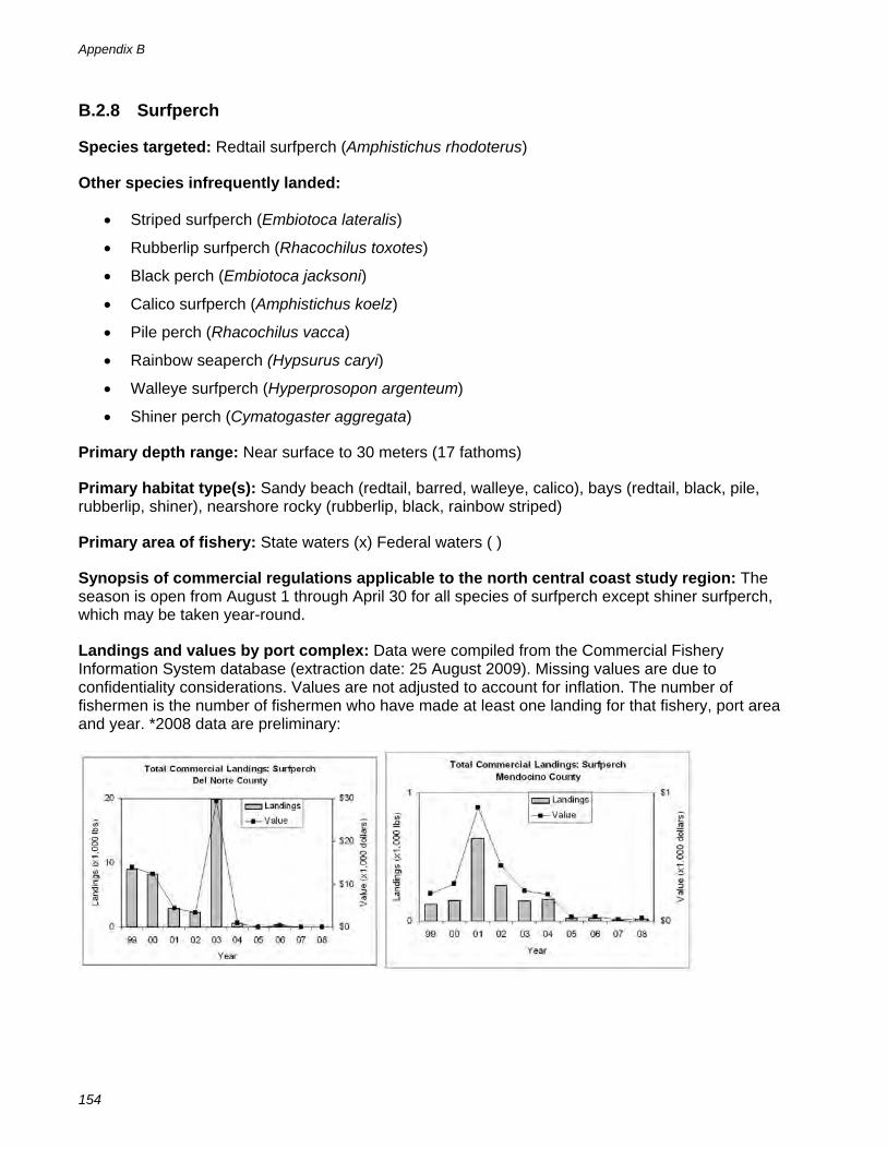
B.2.8 Surfperch
Species targeted: Redtail surfperch (Amphistichus rhodoterus)
Other species infrequently landed:
Striped surfperch (Embiotoca lateralis)
Rubberlip surfperch (Rhacochilus toxotes)
Black perch (Embiotoca jacksoni)
Calico surfperch (Amphistichus koelz)
Pile perch (Rhacochilus vacca)
Rainbow seaperch (Hypsurus caryi)
Walleye surfperch (Hyperprosopon argenteum)
Shiner perch (Cymatogaster aggregata)
Primary depth range: Near surface to 30 meters (17 fathoms)
Primary habitat type(s): Sandy beach (redtail, barred, walleye, calico), bays (redtail, black, pile, rubberlip, shiner), nearshore rocky (rubberlip, black, rainbow striped)
Primary area of fishery: State waters (x) Federal waters ( )
Synopsis of commercial regulations applicable to the north central coast study region: The season is open from August 1 through April 30 for all species of surfperch except shiner surfperch, which may be taken year-round.
Landings and values by port complex: Data were compiled from the Commercial Fishery Information System database (extraction date: 25 August 2009). Missing values are due to confidentiality considerations. Values are not adjusted to account for inflation. The number of fishermen is the number of fishermen who have made at least one landing for that fishery, port area and year. *2008 data are preliminary:

Appendix C: Profile of the Recreational Fishery
This appendix provides in depth information on marine recreational fisheries occurring within the north coast study region, and is supplementary to information provided in section 5.4 (Recreational Fisheries) of this regional profile. The appendix is organized as follows:
C.1 Data Used to Characterize the Recreational Fishery
C.2 CRFS Fishery Statistics, 2005-2008
C.3 DFG Ocean Salmon Catch Statistics, 1999- 2008
C.4 CPFV Logbook Data, 1999 to 2008: Dungeness Crab Catch Statistics
C.1 Data Used to Characterize the Recreational Fishery
The California Recreational Fisheries Survey (CRFS) is the primary source of data used in characterizing the recreational fishery for this profile. California implemented the survey in 2004 and it is a collaborative effort between DFG and the Pacific States Marine Fisheries Commission (PSMFC). The data are maintained by the PSMFC on the Recreational
Fisheries Information Network (RecFIN). Catch and effort data are collected at more than 400 publicly-accessible sites state-wide during day-light hours and aboard CPFVs. The survey generally does not sample catch for night-time fishing, CPFV dive charters, and invertebrate fisheries, although a limited sampling effort for Dungeness crab is being conducted in 2008.
A telephone survey of licensed anglers is used to estimate effort information for night-time fishing and for boats that return to non-accessible marinas. A separate telephone survey of vessel operators is used to estimate CPFV effort. Estimates of catch and effort are reported monthly by six geographical districts along California’s coastline and by mode of fishing. Two of these districts occur in the study region: the Redwood District, consisting of Del Norte and Humboldt counties, and the Wine District, consisting of Mendocino County. Within these districts, 45 Beach and bank sites, 23 Man-made sites, 5 party boat landing sites, and 22 launch ramp sites are sampled on a regular basis for catch and effort information. It should be noted that the CRFS catch estimates for northern California represent trips occurring from the southern Mendocino County line to the Oregon-California border, while the MLPA north coast study region extends from Point Arena to the Oregon-California border. Additional details about CRFS may be found at http://www.dfg.ca.gov/marine/crfs.asp, and CRFS data are available at http://www.recfin.org.
Prior to the CRFS, the California recreational fishery was sampled by the Marine Recreational Fisheries Statistics Survey (MRFSS) from 1981 through 2003. MRFSS estimates are not directly comparable to CRFS estimates. Further details regarding the MRFSS may be found at http://www.st.nmfs.noaa.gov/st1/recreational/index.html, and MRFSS data and estimates are available at http://www.recfin.org.
An additional source of catch and effort data for CPFVs is fishing activity logbooks. This logbook is completed by the vessel operator and must be submitted monthly to DFG. Logbook data are maintained by DFG in the Commercial Fishery Information System database (CFIS).

Appendix C
156
C.2 CRFS Fishery Statistics, 2005 to 2008
C.2.1 Catch and Effort by CRFS Sampling District for the North Coast of California
CRFS provides separate catch and effort estimates for Del Norte and Humboldt counties (Redwood District) and for Mendocino county (Wine District). Angler trip effort is higher in for shore and private boat trips in Del Norte and Humboldt counties, while CPFV angler trip effort is markedly higher out of Mendocino county (Figure IV-1). Catch for targeted finfish species varies greatly between sampling districts as well (Figure IV-2). For example, nearly all California halibut are harvested in the Redwood District (Del Norte and Humboldt), while Pacific halibut catches occur primarily out of the Wine district (Mendocino).
Figure C-1: Estimated proportion of fishing effort by CRFS sampling districts, 2005 to 2008
0%
10%
20%
30%
40%
50%
60%
70%
80%
90%
100%
Man-Made Beach and Bank CPFV Private Boat
Fishing Mode
Per
cent
of A
ngle
r Trip
s
Del Norte and Humboldt CountyMendocino County
Source: CRFS data extracted from the RecFIN database at http://www.recfin.org/forms/est2004.html. Query represents all angler trips for all modes of fishing for all marine waters. Extraction date: October 28, 2009

Profile of Recreational Fisheries
157
Figure C-2: Estimated proportion of catch of finfish by taxonomic group and sampling region, 2005 to 2008
0%10%20%30%40%50%60%70%80%90%
100%
Anchovie
s
Cabezo
n and sculpins
Californ
ia halibut
Herrin
gs
Lingcod and gre
enlin
gs
Other f
latfish
Pacific
halib
ut
Rockfi
shes
Sharks
and rays
Silversi
des
Smelts
Surfperch
es
Tunas a
nd mack
erels
Type of Fish
Per
cent
age
of C
atch
( i
n nu
mbe
rs o
f fis
h) Del Norte and Humboldt Counties
Mendocino County
Source: CRFS data extracted from the RecFIN database at http://www.recfin.org/forms/est2004.html. Extraction date: August 28, 2008. Query represents percentage of catch for numbers of A+ B1 fish by supergroup or common name for all modes for inland and marine waters within 3 miles of shore for Redwood and Wine Districts.
C.2.2 CRFS Catch Estimates by Species and Fishing Mode
Finfish catch species and catch proportions vary by fishing mode. Figures C-2 through C-6 show proportions of catch by type of finfish each mode in the study region.

Appendix C
158
Figure C-3: Estimated proportion of harvested finfish ( in numbers of fish) from man-made structures, 2005 to 2008
Man-made Structures ANCHOVIES
SURFPERCHES
SILVERSIDES
ROCKFISHES
GREENLINGS &LINGCOD
SCULPINS
ALL OTHER FISHES
Source: CRFS data extracted from the RecFIN database at http://www.recfin.org/forms/est2004.html. DFG’s Ocean Salmon Project (OSP) provided estimates of the total recreational take of ocean salmon. Query based on sampler examine and angler reported dead fish (A+B1) catch by mode for fish by common name and supergroup for inland and marine waters less than 3 miles from shore in Redwood and Wine districts. Extraction date: November 19, 2009.
Figure C-4: Estimated proportion of harvested finfish (in numbers of fish) from beaches and banks, 2005 to 2008
Beaches and Banks
SURFPERCHES
SMELTS
ROCKFISHES
GREENLINGS &LINGCOD
CHINOOK SALMON
ALL OTHER FISHES
Source: CRFS data extracted from the RecFIN database at http://www.recfin.org/forms/est2004.html. DFG’s Ocean Salmon Project (OSP) provided estimates of the total recreational take of ocean salmon. Query based on sampler examine and angler reported dead fish (A+B1) catch by mode for fish by common name and supergroup for inland and marine waters less than 3 miles from shore in Redwood and Wine districts. Extraction date: November 19, 2009.

Profile of Recreational Fisheries
159
Figure C-5: Estimated proportion of harvested finfish (in numbers of fish) from CPFVs, 2005 to 2008
CPFVs
ROCKFISHES
CHINOOK SALMON
GREENLINGS &LINGCOD
CABEZON &SCULPINS
FLATFISHES
ALL OTHER FISHES
Source: CRFS data extracted from the RecFIN database at http://www.recfin.org/forms/est2004.html. DFG’s Ocean Salmon Project (OSP) provided estimates of the total recreational take of ocean salmon Query based on sampler examine and angler reported dead fish (A+B1) catch by mode for fish by common name and supergroup for inland and marine waters less than 3 miles from shore in Redwood and Wine districts. Extraction date: November 19, 2009.
Figure C-6: Estimated proportion of harvested finfish ( in numbers of fish) from private boats, 2005 to 2008
Private and Rental Boats ROCKFISHES
CHINOOKSALMONGREENLINGS& LINGCODANCHOVIES
FLATFISHES
CABEZON &SCULPINSTUNAS ANDMACKERELSALL OTHERFISHES
Source: CRFS data extracted from the RecFIN database at http://www.recfin.org/forms/est2004.html. DFG’s Ocean Salmon Project (OSP) provided estimates of the total recreational take of ocean salmon Query based on sampler examine and angler reported dead fish (A+B1) catch by mode for fish by common name and supergroup for inland and marine waters less than 3 miles from shore in Redwood and Wine districts. Extraction date: November 19, 2009.

Appendix C
160
C.2.3 CRFS Angler Reported Finfish Target Species
Table C-1 displays the primary target species as reported by anglers in interviews with CRFS samplers. The target “anything” is recorded when anglers are not targeting a particular species or type of fish. The tables are based on raw (un-extrapolated) interview data collected at fishing sites.
Table C-1: Top ten reported primary targets (finfish) for angler trips by mode, 2004 to 2008
Rank Man-made Beach and bank CPFVs Private and rental boats
1 anything surfperch family rockfish family Chinook
2 surfperch family anything bottomfish Rockfish family
3 rockfish family redtail surfperch Chinook bottomfish
4 lingcod rockfish family lingcod California halibut
5 bottomfish bottomfish anything salmon genus
6 Chinook lingcod California halibut lingcod
7 black rockfish salmon family Pacific halibut Pacific halibut
8 kelp greenling cabezon salmon family black rockfish
9 sharks Chinook black rockfish anything
10 redtail surfperch steelhead northern anchovy sharks
Source: CRFS data extracted from the RecFIN database at http://www.recfin.org/forms/dsamp.htm. Query represents type 1 records (angler information) for reported primary target in all modes in inland and marine waters within 3 miles of shore for Del Norte, Humboldt, and Mendocino Counties. Extraction date: November 19, 2009
C.3 DFG Ocean Salmon Catch Statistics, 2005-2008
Although data collected on recreational ocean salmon catch and effort is collected collaboratively with CRFS, catch statistics for salmon are estimated and reported by the DFG Ocean Salmon Project. Chinook salmon is the primary target species in ocean waters. Effort for Chinook is a significant portion of angler trips in the study region.
Table C-2 : Angler trips targeting salmon by month, 2005-2008
month 2005 2006 2007 Total
February 869 289 249 1,407
March 521 298 855 1,674
April 841 800 692 2,333
May 3,184 6,603 4,294 14,081
June 10,114 11,879 11,064 33,057
July 8,318 9,113 11,212 28,643
August 13,973 4,051 7,450 25,474
September 3,799 4,386 1,726 9,911
October 22 0 25 47
November 0 0 0 0
Annual total 41,641 37,419 37,567 116,627
Source: DFG Ocean Salmon Project. Extracted November 19, 2009
Note: The 2008 season was closed

Profile of Recreational Fisheries
161
Table C-3: Ocean salmon catch of Chinook (King) salmon by fishery 2005-2007
CPFV Private Skiffs
King Unavailable Total Catch Effort King Unavailable Total Catch Effort
Crescent City
2005 0 0 0 0 1,498 315 1,813 2,502
2006 0 0 0 0 756 158 914 1,478
2007 0 0 0 0 871 284 1,155 2,082
Total 0 0 0 0 3,125 756 3,881 6,062
Eureka
2005 1,045 439 1,484 922 15,001 11,043 26,044 13,905
2006 816 358 1,174 745 14,831 6,904 21,735 14,228
2007 1,904 476 2,380 1,553 16,121 6,723 22,844 16,808
Total 3,765 1,273 5,038 3,220 45,953 24,671 70,624 44,941
Fort Bragg
2005 7,905 1,886 9,791 8,879 14,278 7,863 22,141 15,433
2006 4,203 491 4,694 6,864 9,790 2,643 12,433 14,104
2007 1,588 120 1,708 5,437 4,163 906 5,069 11,687
Total 13,696 2,497 16,193 21,180 28,231 11,412 39,643 41,224
All Fisheries
2,005 8,950 2,325 11,275 9,801 30,777 19,221 49,998 31,840
2,006 5,019 849 5,868 7,609 25,377 9,706 35,083 29,810
2,007 3,492 596 4,088 6,990 21,155 7,912 29,067 30,577
Total 17,461 3,770 21,231 24,400 77,309 36,839 114,148 92,227
Source: DFG Ocean Salmon Project. Extracted November 19, 2009
Note: Unavailable dead includes 5% dropoff mortality for all contacts (legal & sublegal)
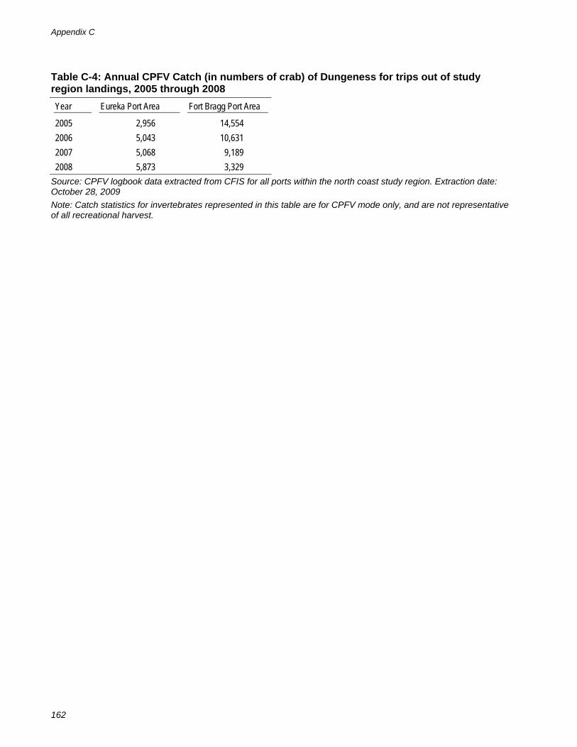
C.4 CPFV Logbook Data, 1999 to 2008: Dungeness Crab Catch Statistics
The CRFS and MRFSS programs have not historically collected data on invertebrate harvest in recreational fisheries, and CPFV logbook data is currently the best available source for the Dungeness crab catch and effort for CPFV mode. Table IV-4 displays catch for Dungeness crab taken traps and hoopnet from CPFVs.. Unlike CRFS and MRFSS estimates, CPFV logbook data is not reported at the level of resolution needed to isolate trips that occurred within state waters.
Appendix C
162
Table C-4: Annual CPFV Catch (in numbers of crab) of Dungeness for trips out of study region landings, 2005 through 2008
Year Eureka Port Area Fort Bragg Port Area
2005 2,956 14,554
2006 5,043 10,631
2007 5,068 9,189
2008 5,873 3,329
Source: CPFV logbook data extracted from CFIS for all ports within the north coast study region. Extraction date: October 28, 2009
Note: Catch statistics for invertebrates represented in this table are for CPFV mode only, and are not representative of all recreational harvest.

Appendix D: Special-Status Species Likely to Occur in the Study Region
D.1 List of Special-Status Species
Listed below are species that are protected under state or federal law and occur within the MLPA North Coast Study Region for consideration in marine protected area planning. Some of these species are described in further detail in section 3.2.4 of this regional profile.
Table D-1: Special-status species likely to occur in northern California
Common Name Scientific Name Federal Status State Status Other Status
Mammals
Blue whale Balaenoptera musculus musculus E MMPA
Fin whale Balaenoptera physalus E MMPA
Humpback whale Megaptera novaeangliae E MMPA
North Pacific right whale Eubalaena japonica E MMPA
Gray whale Eschrichtius robustus D MMPA
Sei whale Balaenoptera borealis E MMPA
Sperm whale Physeter macrocephalus E MMPA
Killer whale Orcinus orca PT, SC (NMFS) MMPA
Dall’s porpoise Phocoenoides dalli MMPA
Pacific white-sided dolphin Lagenorhynchus obliquidens MMPA
Risso’s dolphin Grampus griseus MMPA
Northern right whale dolphin Lissodelphis borealis FP MMPA
California sea lion Zalophus californianus MMPA
Northern fur seal Callorhinus ursinus MMPA
Harbor seal Phoca vitulina MMPA
Northern elephant seal Mirounga angustirostris FP MMPA
Southern sea otter Enhydra lutris nereis T FP MMPA
Birds
Common Loon Gavia immer SSC(FP) IUCN
Short-tailed Albatross Phoebastria albatrus E SSC(FP) IUCN
Black-footed Albatross Phoebastria nigripes SC (FWS)
Ashy Storm-Petrel Oceanodroma homochroa BCC (FWS)
SSC(SP) IUCN
Fork-tailed Storm-Petrel Oceanodroma furcata SSC(FP) IUCN
American White Pelican Pelecanus erythrorhynchos SSC(FP) IUCN
American Bittern Botaurus lentiginosus BCC (FWS) IUCN
White-faced Ibis Plegadis chihi SC (FWS)
Harlequin Duck Histrionicus histrionicus SC (FWS) SSC(SP)
Western Snowy Plover Charadrius alexandrinus nivosus T, BCC (FWS) SSC(FP)
Black Oystercatcher Haematopus bachmani BCC (FWS)
Whimbrel Numenius phaeopus BCC (FWS)

Appendix D
164
Common Name Scientific Name Federal Status State Status Other Status
Long-billed Curlew Numenius americanus BCC (FWS)
Marbled Godwit Limosa fedoa BCC (FWS)
Black Turnstone Arenaria melanocephala BCC (FWS)
Red Knot Calidris canutus BCC (FWS)
Elegant Tern Sterna elegans BCC (FWS) SSC(TP) IUCN
Caspian Tern Sterna caspia BCC (FWS)
Marbled Murrelet Brachyramphus marmoratus marmoratus
T E
Cassin's Auklet Ptychoramphus aleuticus BCC (FWS) SSC(TP) IUCN
Rhinoceros Auklet Cerorhinca monocerata SSC(TP) IUCN
Double-crested Cormorant Phalacrocorax auritus SSC(WL) IUCN
Black-crowned Night Heron Nycticorax nycticorax SC IUCN
Canadian Goose Branta canadensis leucopareia T
Saltmarsh Common Yellowthroat Geothlypis trichas sinuosa SC BCC (FWS)
Black Brant Branta bernicla nigricans SSC(TP)
Redhead Aythya americana SSC(SP)
Bufflehead Bucephala albeola SSC(TP)
Osprey Pandion haliaetus SSC(WL)
Northern Harrier Circus cyaneus SSC(TP)
Golden Eagle Aquila chrysaetos SSC(FP), FP
Bald Eagle Haliaeetus leucocephalus T E
Merlin Falco columbarius SSC(WL)
Long-billed Curlew Numenius americanus SC
California Gull Larus californicus SSC(WL)
Willow Flycatcher Empidonax traillii E
Tufted Puffin Fratercula cirrhata SSC(FP) IUCN
Reptiles
Loggerhead sea turtle Caretta caretta T
Fish
Fish Common Name Scientific Name Federal Status State Status Other Status
Tidewater goby Eucyclogobius newberryi E SSC(QE) IUCN
coast cutthroat trout Oncorhynchus clarkii clarkii SSC
pink salmon Oncorhynchus gorbuscha SSC(QE)
chum salmon Oncorhynchus keta SSC(QE)
Coho salmon - northern California population
Oncorhynchus kisutch T T
chinook salmon - California coastal ESU
Oncorhynchus tshawytscha T
chinook Salmon - spring-run Klamath-Trinity Rivers pop
Oncorhynchus tshawytscha SSC

Specia-Status Species
165
Common Name Scientific Name Federal Status State Status Other Status
steelhead - Klamath Mountains Province ESU summer run
Oncorhynchus mykiss irideus SSC(QT)
steelhead-northern California ESU Oncorhynchus mykiss irideus T SSC(QT)
Green sturgeon Acipenser medirostris SC (NMFS) -Candidate
SSC(QT)
Cowcod Sebastes levis Overfished, SC (NMFS)
Bocaccio Sebastes paucispinis Overfished, SC (NMFS)
Canary rockfish Sebastes pinniger Overfished (NMFS)
Darkblotched Rockfish Sebastes crameri Overfished (NMFS)
Pacific Ocean Perch Sebastes alutus Overfished (NMFS)
Widow rockfish Sebastes entomelas Overfished (NMFS)
Yelloweye rockfish Sebastes ruberrimus Overfished (NMFS)
Eulachon Thaleichthys pacificus SSC(WL)
Bluefin tuna Thunnus thynnus SC
Swordfish Xiphias gladius SC
Garibaldi Hypsypops rubicundus P
White shark Carcharodon carcharias P IUCN, CITES, CMS
Invertebrates
Black abalone Haliotis cracherodii PE, SC (NMFS) P IUCN
Sandy beach tiger beetle Cicindela hirticollis gravida SC
Plant Common Name Scientific Name Federal Status State Status Other Status
Northcoast sand verbena Abronia umbellata ssp. breviflora SC
Sources for special status species list:
Original list from MBNMS
California ESA status: http://www.dfg.ca.gov/whdab/pdfs/TEAnimals.pdf
California Species of Special Concern http://www.dfg.ca.gov/wildlife/species/ssc/index.html
Federal ESA status: http://www.nmfs.noaa.gov/pr/species/esa.htm
Birds of Conservation Concern: http://migratorybirds.fws.gov/reports/bcc2002.pdf
California Natural Diversity Database http://www.dfg.ca.gov/biogeodata/cnddb/pdfs/SPAnimals.pdf

Appendix D
166
D.2 Index of the Listing Codes Used In Table D-1
Federal Listing Codes
ESA: Endangered Species Act of 1973 listing codes
E....................Federally listed as endangered T....................Federally listed as threatened D ...................Federally delisted PE .................Proposed for federal listing as endangered PT .................Proposed for federal listing as threatened PD.................Proposed for federal de-listing Candidate .....Candidate for federal listing as endangered or threatened SC.................Species of concern SC (NMFS) ...Species of concern by the National Marine Fisheries Service SC (FWS) .....Species of concern by the US Fish and Wildlife Service BCC (FWS)...Birds of Conservation Concern by US Fish and Wildlife Service
State Listing Codes
CESA: California Endangered Species Act listing codes
E....................State-listed as endangered T....................State-listed as threatened CE.................Candidate for state listing as endangered CT .................Candidate for state listing as threatened CD.................Considered for state delisting as endangered
SSC: Species of special concern listing codes
(QE) ..............Qualify as endangered (fish list) (QT) ..............Qualify as threatened (fish list) (WL) ..............Watch list (FP)...............First priority (bird list) (SP)...............Second priority (bird list) (TP)...............Third priority (bird list)
Other State listings
FP .................State fully protected animal list P....................Protected species
Other Status Codes
MMPA ...........Protected under the Marine Mammal Protection Act IUCN ............. Included in the World Conservation Union’s Red List of Vulnerable Species CITES ...........Protected under the Convention of International Trade in Endangered Species of Fauna and
Flora CMS..............Protected by the Convention on Migratory Species