appendix b-2 lake murray shoreline management …
TRANSCRIPT

APPENDIX B-2
LAKE MURRAY SHORELINE MANAGEMENT HANDBOOK AND PERMITTING GUIDELINES

SOUTH CAROLINA ELECTRIC & GAS COMPANY
COLUMBIA, SOUTH CAROLINA
SALUDA HYDROELECTRIC PROJECT FERC NO. 516
LAKE MURRAY SHORELINE MANAGEMENT HANDBOOK AND PERMITTING GUIDELINES
FINAL
South Carolina Electric & Gas Company Lake Management Department
Columbia, South Carolina 29218 Telephone: (803) 217-9221
JULY 2009
Prepared by:

SOUTH CAROLINA ELECTRIC & GAS COMPANY COLUMBIA, SOUTH CAROLINA
SALUDA HYDROELECTRIC PROJECT FERC NO. 516
LAKE MURRAY SHORELINE MANAGEMENT HANDBOOK AND PERMITTING GUIDELINES
FINAL
JULY 2009
Prepared by:

i
SOUTH CAROLINA ELECTRIC & GAS COMPANY COLUMBIA, SOUTH CAROLINA
SALUDA HYDROELECTRIC PROJECT
FERC NO. 516
LAKE MURRAY SHORELINE MANAGEMENT HANDBOOK PERMITTING GUIDELINES
FINAL
TABLE OF CONTENTS
1.0 ............................................................................................................... 1 INTRODUCTION
2.0 ....................................................................................... 3 LAND USE CLASSIFICATIONS2.1 ........................................................................................................ 3 Multi-Purpose
2.1.1 ................................................................................................. 3 Easement2.1.2 ................................................................................................ 3 Commercial2.1.3 ................................................................................................ 4 Buffer Zone2.1.4 .................................................................................. 5 Future Development
2.2 .................................................................................................. 8 Public Recreation2.3 .............................................................................................. 8 Forest Management2.4 ........................................................................................................ 8 Natural Areas2.5 ............................................................................................... 11 Project Operations
3.0 ........................................................................................ 12 ENVIRONMENTAL POLICIES3.1 ................................................................................ 12 General Policy and Purpose3.2 ..................................................................................... 12 Water Quality Standards3.3 ............................................................................................. 12 Effluent Discharges3.4 ..................................................................................................... 12 Aquatic Plants3.5 ............................................................................................. 13 Undeveloped Areas3.6 ......................................................................... 13 Wildlife and Game Management
4.0 ........................................................................................................ 14 EXCLUSION ZONE
5.0 ..................................................................... 15 PUBLIC FISHING, BOATING & HUNTING5.1 ........................................................................................... 15 Fishery Management5.2 ..................................................................................................... 16 Boating Safety5.3 ..................................................................................................... 16 Public Hunting
6.0 ........................................................................................................... 17 PUBLIC ACCESS
7.0 ............................................ 18 SHORELINE ACTIVITIES/DEVELOPMENT PERMITTING7.1 ................................................................................................................ 18 General7.2 ................................................................................... 18 Docks and Private Access
7.2.1 .......................................................................... 19 Private Individual Docks7.2.2 ........................................................................... 26 Private Common Docks7.2.3 .............. 31 Community Access Areas – Boat Ramps and Courtesy Docks7.2.4 ............................. 36 Private Multi-Slip (Inclusive of Private Boating Clubs)7.2.5 ............. 43 Commercial Public Marinas (Inclusive of Public Boating Clubs)
7.2.5.1 .................................. 45
Commercial Public Marinas Accommodating Twenty (20) or Fewer Watercraft (Figure 7-16)

Table of Contents (Cont’d)
ii
7.2.5.2 Commercial Public Marinas Accommodating Twenty One to One Hundred (21 - 100) Watercraft (Figure 7-17)...... 46
7.2.5.3 Commercial Public Marinas Accommodating One Hundred One to Two Hundred Fifty (101 - 250) Watercraft (Figure 7-18)......................................................... 48
7.2.5.4 Additional Specifications for all Public Marinas...................... 49 7.2.6 Watercraft Limitations .............................................................................. 55 7.2.7 Dock Modifications................................................................................... 55 7.2.8 Dock Policy on Forest Management Property ......................................... 55
7.3 Boat Ramps......................................................................................................... 58 7.4 Boat Lifts ............................................................................................................. 58 7.5 Personal Watercraft Lifts ..................................................................................... 59 7.6 Marine Railways .................................................................................................. 59 7.7 Floating Platforms or Tubes and Other Water Toys ............................................ 59 7.8 Water Removal.................................................................................................... 59
7.8.1 Residential Withdrawals .......................................................................... 59 7.8.2 Commercial Withdrawals ......................................................................... 60
7.9 Erosion Control (Shoreline Stabilization)............................................................. 60 7.10 Excavation Activities............................................................................................ 66 7.11 Prohibited Activities/Structures............................................................................ 69 7.12 Environmentally Sensitive Area (ESA) Restrictions ............................................ 70 7.13 Access Path ........................................................................................................ 71 7.14 Limited Brushing.................................................................................................. 71 7.15 Non-disturbance Areas........................................................................................ 72 7.16 Woody Debris Management................................................................................ 76
7.16.1 Submerged Woody Debris....................................................................... 76 7.16.2 Floating Woody Debris ............................................................................ 76 7.16.3 Shoreline Woody Debris .......................................................................... 77
7.17 Permitting Application Procedure ........................................................................ 77 7.18 Permitting Fees ................................................................................................... 78 7.19 Violations............................................................................................................. 78 7.20 Miscellaneous...................................................................................................... 79
LIST OF TABLES
Table 7-1: Agency’s Involved in Permitting Process for Commercial Public Marina ................................................................................................................. 44
LIST OF FIGURES
Figure 2-1: Land Management Restrictions for SCE&G-owned Future Development Properties ....................................................................................... 6
Figure 2-2: Land Management Prescriptions for SCE&G-owned Future Development Properties ....................................................................................... 7
Figure 2-3: Minimum Distance of All Docks From ESA’s....................................................... 10
Figure 7-1: Typical Layout of Individual Docks on Easement Properties............................... 22
Figure 7-2: Typical Layout of Individual Docks on Pre-2007 Future Development Properties...................................................................................... 23

Table of Contents (Cont’d)
Figure 7-3: ...................................................................................... 24
Typical Layout of Individual Docks on Post-2007 Future Development Properties
Figure 7-4: ...................................................................................... 25
Permanent Structures for Individual Docks on Post-2007 Future Development Properties
Figure 7-5: .............................. 27 Example of Common Dock Layout on Easement Properties
Figure 7-6 ...................................................................................... 28
Example of Common Dock Layout on Pre-2007 Future Development Properties
Figure 7-7: ...................................................................................... 29
Example of Common Dock Layout on Post-2007 Future Development Properties
Figure 7-8: ........................................... 30 Clearances in Coves for Community Access Docks
Figure 7-9: ........................................................................................... 33
Example of Community Boat Ramp and Courtesy Dock on Easement Properties
Figure 7-10: ................................................................. 34
Example of Community Boat Ramp and Courtesy Dock on Pre-2007 Future Development Properties
Figure 7-11: ................................................................. 35
Example of Community Boat Ramp and Courtesy Dock on Post-2007 Future Development Properties
Figure 7-12: ............................... 39 Example of Multi-slip Dock Layout on Easement Properties
Figure 7-13: ...................................................................................... 40
Example of Multi-slip Dock Layout on Pre-2007 Future Development Properties
Figure 7-14: ...................................................................................... 41
Example of Multi-slip Dock Layout on Post-2007 Future Development Properties
Figure 7-15: ....................................................................................................... 42
Allowable Multi-slips on Easement Properties – with and without Greenspaces
Figure 7-16: ............................................................................................. 51
Potential Layout for Commercial Marina Facility Accommodating 20 or Fewer Watercraft
Figure 7-17: ................................................................................................. 52
Potential Layout for Commercial Marina Facility Accommodating 21 to 100 Watercraft
Figure 7-18: .......................................................................................... 53
Potential Layout for Commercial Marina Facility Accommodating 101 to 250 Watercraft
Figure 7-19: .................................................................................................. 54
Maximum Encroachment Distances in Coves for Commercial Marina Facilities
Figure 7-20: ................................................................... 64 Example of Shoreline Rip-rap Detail
Figure 7-21: ................. 65 General Guidance for Typical Shoreline Stabilization Retaining Wall
Figure 7-22: ................................................................................... 68 Guidance for Excavations
Figure 7-23: ................................................. 73 Target Coverage on Disturbed Vegetation Zone
Figure 7-24: ............................... 74
Land Management Prescriptions for Future Development Properties - Minimum Vegetation Height and Tree Spacing
Figure 7-25: ......................................................... 75 Target Coverage of Understory Vegetation
iii
1
SOUTH CAROLINA ELECTRIC & GAS COMPANY COLUMBIA, SOUTH CAROLINA
SALUDA HYDROELECTRIC PROJECT
FERC NO. 516
LAKE MURRAY SHORELINE MANAGEMENT HANDBOOK AND PERMITTING GUIDELINES
FINAL
1.0 INTRODUCTION
The work of clearing the site for the Saluda River Hydroelectric Development was
started in April of 1927 under a permit granted by the Federal Power Commission to the
Lexington Water Power Company. In July of 1930 Lake Murray reached an elevation of 300’
Plant Datum (PD). The following December, the first electric power, 10,000 kilowatts, was
delivered.
At the time of its completion, Saluda Dam was the largest earthen dam for power
purposes in the world. The dam itself is 213 feet high and contains over 11 million cubic yards
of material. Lake Murray is approximately 41 miles long with a maximum width of 14 miles and
contains 650 billion gallons of water. It has a shoreline of approximately 691 miles including the
islands.
Lake Murray experiences considerable water level fluctuations. In the Saluda River
watershed, about 75 percent of the normal rainfall comes in the first six months of the calendar
year. The full pool lake level can reach 360’ PD; however the normal high lake level is
approximately 358’ PD. Saluda Hydro is primarily used by South Carolina Electric & Gas
Company (SCE&G) to provide reserve generation in response to system emergencies.
However, the reservoir is also managed in a manner that provides appropriate downstream
flows and responds to pass inflows from precipitation within the drainage basin. More
information on operations can be found at www.sceg.com/en/my-community/lower-saluda-river.
Over the years, Lake Murray has been, and still is, a major source of power generation
and provider of recreational and commercial resources for South Carolina residents and visitors.
In the late 1960’s a rapid change in the character and rate of development began to take place.
Today, there are numerous formal recreation sites dispersed around Lake Murray that support
boat launches, marinas, boat slips, wet and dry storage, campgrounds, picnic areas, beaches,
fishing areas and piers, trails, and playgrounds. The irregular shoreline perimeter, with its

numerous forested peninsulas, inlets and islands, provides excellent outdoor recreational
opportunities. The shoreline also supports many permanent residences.
As development increases, however, the very values that attract families and visitors to
the lake may be threatened unless a substantial effort is made to protect the lake environment
from degradation. South Carolina Electric & Gas Company (SCE&G), as owner and licensee of
Federal Energy Regulatory Commission Project No. 516, realizes the need for formulation of
rules and regulations to promote and enhance the recreational potential of Lake Murray and
protect its environmental quality.
SCE&G manages its lands around Lake Murray according to a Shoreline Management
Plan (SMP) and the Shoreline Management Handbook and Permitting Guidelines (Handbook),
both of which are designed to comply with the terms of the Project License, regulations, and
FERC orders. The aim is to provide a balance among shoreline development, recreational use,
and environmental protection. A component of the SMP is SCE&G’s Permitting Program, which
is operated in compliance with a general permit (GP) issued to SCE&G by the US Army Corps
of Engineers and the South Carolina Department of Health and Environmental Control
(SCDHEC), pursuant to the Clean Water Act (CWA), and the FERC license. The GP authorizes
SCE&G to be the residential permitting authority for the lands comprising Lake Murray’s
shoreline. Project applicants and lake users must obtain the appropriate permit(s) for various
activities and developments, and must adhere to the established regulations that help protect
the lake shoreline and waters. SCE&G’s Lake Management Department is responsible for
enforcing FERC directives regarding authorized and unauthorized uses of Lake Murray waters
and land within the project boundary. FERC directives require SCE&G to prevent or halt
unauthorized actions by taking measures to stop such actions.
This Handbook details guidelines and policies protecting the Lake Murray shoreline and
waters, and the specifics of SCE&G’s Permitting Program. More information is available by
contacting the Lake Management Department. It is a requirement to consult with the Lake
Management Department before beginning any project around the lake. The telephone number
for the Lake Management Department is (803) 217-9221.
2

2.0 LAND USE CLASSIFICATIONS
SCE&G has identified five distinct land management classifications for the land within
the Project boundary line (PBL). Although SCE&G aims to manage its lands according to this
classification system, the public has the right of entry on SCE&G-owned lands within the Project
Boundary Line regardless of classification, with the exception of lands reserved and used for
Project operations and certain leased properties that are operated under a fee agreement. The
classifications, which are described below, consist of Multi-purpose, Public Recreation, Forest
Management, Natural Areas, and Project Operations.
2.1 Multi-Purpose
Multi-purpose lands include lands owned by SCE&G, lands sold by SCE&G, and
lands never owned by SCE&G but over which SCE&G retained certain easement rights.
All of these lands are contained within the PBL. Generally, SCE&G divides them into
four sub-classifications: easement, commercial, buffer zone, and future development
lands.
2.1.1 Easement
Lands that SCE&G has sold/or never owned but holds and retains
easements on within the PBL. These lands may support a variety of uses
including privately run commercial ventures and residential developments.
2.1.2 Commercial
SCE&G manages lands within this sub-classification primarily through its
permitting program, which guides new or modified developments (e.g., expansion
of existing facilities) as detailed in this document (see Section 7.0). Such uses
include the following:
Commercial and private marinas and boat clubs (for-profit and
nonresidential);
Commercial docks, boat ramps, bulkheads, and other supporting
facilities;
3
Commercial RV parks, hotels, resorts, bait shops, boat tours, etc.;
Restaurants with shoreline access such as docks, decks, etc.;
Golf courses with lake access facilities; and
Industrial facilities.
2.1.3 Buffer Zone
A 75-foot wide1 vegetated buffer zone, located between the 360’ PD
contour and the back property development, is maintained adjacent to all
easement lands sold by SCE&G after the issuance of the 1984 license. SCE&G
maintains the Buffer Zone lands as vegetated areas intended to protect and
enhance the Project’s scenic, recreational, and environmental values in the area
bordering the Lake Murray shoreline. SCE&G will manage Buffer Zones
associated with lands sold after 2007 as non-disturbance areas.
Use of SCE&G’s buffer zone is entirely at the discretion of SCE&G as
landowner. Owners of adjoining lands (back property owners) are given the right
of access, by foot, to and from the lake through the buffer zone, but are not
permitted to encroach on the land without written consent from SCE&G (see
Section 7.11 for information on prohibited activities in the Buffer Zones). For
lands sold after 2007, lake access for back property owners is limited to a narrow
meandering path in accordance with a dock permit and as specified in Section
7.13. See Section 7.14 for further information regarding limited brushing. Access
to Buffer Zone lands by the public is allowed for passive activities such as bird
and wildlife viewing, and shoreline fishing. However, prohibitive uses include
overnight camping, building fires, hunting, discharge of firearms, motorized
vehicles, or any activity that may adversely impact the land.
1 There are some areas where the width of the land between the 360’ PD contour and the PBL is less than 75’, and
thus the buffer zone is less than 75’.
4

2.1.4 Future Development
Lands classified as future development are SCE&G-owned and located
between the 360’ PD contour and the PBL. They are available for sale only to
the back property owner with certain restrictions encompassed in SCE&G’s
permitting program, as detailed in this document (See Section 7.0, Figure 2-1,
and Figure 2-2), and as regulated by FERC.
5

Figure 2-1: Land Management Restrictions for SCE&G-owned Future Development Properties
6

Figure 2-2: Land Management Prescription for SCE&G-owned Future Development Properties
7
8
2.2 Public Recreation
Recreation lands include existing parks, properties set aside for future recreation,
and publicly available islands owned by SCE&G. SCE&G manages the areas
individually based on the specific, designated recreational activities they support,
including swimming, picnicking, and boat launching. Dreher Island State Park is the only
public site that provides formal camping; however, individuals can also camp on
SCE&G-owned islands and other lands such as Bundrick Island, River Bend, and
Sunset, unless otherwise posted.
2.3 Forest Management
Forest Management lands have been set aside for compatible recreation, scenic,
aesthetic, and timber management purposes. SCE&G forest resources are managed
according to the South Carolina Forestry Commission’s Best Management Practices.
SCE&G restricts its timber management operations in certain areas, such as on cliffs or
steep slopes, or in atypical groups of trees.
2.4 Natural Areas
Natural areas consist of lands that warrant special protection because they
provide important habitat for various wildlife species, including the recreational fishery.
Shallow, shoreline waters; large wetland areas; areas having cultural and/or historical
significance; and Environmentally Sensitive Areas (ESAs) are included in the natural
areas classification and are protected.
ESAs are areas that have been designated as warranting special protection
because they contain one or more of a variety of characteristics. They consist of habitat
areas known to be occupied by rare, threatened, or endangered species; rare or
exemplary natural communities; significant land forms and geological features; wetlands
and shallow coves; and other areas determined to be critical to the continued existence
of native species, such as spawning and nesting habitat. SCE&G has identified five
types of ESAs, which are described in more detail in the SMP and are summarized here.
They consist of the following:

1) Continuous Vegetated Shoreline, which is vegetated land composed
primarily of buttonbush and willow species for at least 66 feet of linear
shoreline length.
2) Intermittent Vegetated Shoreline, which is vegetated shoreline at least
66 feet in length where between 16 and 40 percent of the length is
composed of gaps of unvegetated land measuring more than 20 feet
long.
3) Shallow Coves with Stream Confluences where streams enter the
lake and form coves and lake water is above the 355’ PD contour line.
4) Bottomland Hardwood consisting of continuous linear shoreline at least
66 feet in length with coverage of bottomland hardwood.
5) Wet Flats consisting of continuous linear shoreline at least 66 feet in
length with coverage of wet flats.
6) Shallow shoals and rocky shores generally consist of submerged
ridges and hill tops located above the 352’ PD contour.
Natural Areas are not available for sale, and docks, excavations, and shoreline
activity are not permitted in these areas. Also, ESAs have protective non-disturbance
setbacks associated with them where vegetation clearing and developments including
docks and other structures are prohibited, see Section 7.12 for more information on
ESAs. No docks (Figure 2-3), excavations, or other developments are allowed within 50
feet of the ESA. After 2007, changes to the SMP prohibit brushing of any sort within
newly established 75-ft buffer zones.
9

Figure 2-3: Minimum Distance of All Docks From ESA’s
10

11
2.5 Project Operations
SCE&G-owned and managed lands are required for operation of the Saluda
Project. Public access to these lands is restricted to ensure public safety or to assure
the security of the infrastructure system.
3.0 ENVIRONMENTAL POLICIES
3.1 General Policy and Purpose
The Lake Murray Shoreline Management Plan shall maintain and conserve the
area’s natural and human-made resources.
The purpose of the policy is to comply with the terms of the Project No. 516
License, the regulations, and the orders of the FERC, while providing recreational
opportunities and environmental protections.
3.2 Water Quality Standards
SCE&G will conduct a continuing water quality monitoring program at Lake
Murray. SCDHEC classifies Lake Murray’s waters as “Freshwater,” which means they
are suitable for swimming, fishing, and other water-related recreational activities.
3.3 Effluent Discharges
Lake Murray is classified as a “no sewage discharge” lake. SCE&G personnel
will continue to notify appropriate government officials of any unauthorized effluent
discharges which are discovered by SCE&G personnel or others. Anyone found to have
an unauthorized discharge source within the project boundary line will be required to
remove it.
Commercial public marinas providing facilities to remove effluent wastes from
boats must meet SCDHEC regulations. See requirements for marinas in Section 7.2.5.
3.4 Aquatic Plants
Invasive and exotic aquatic plants can become a significant nuisance to
recreation and project operations if their populations are not properly maintained. Some
of the common problem species found in Lake Murray include hydrilla, water primrose,
and several species of pondweed. When managing invasive and exotic aquatic plants it
is important to also protect the native plant species, aquatic ecosystems, and fish
habitat. This requires the integration and use of specific Best Management Practices
(BMPs) appropriate to the regional and local conditions.
12

SCE&G’s Lake Management Department, in cooperation with the South Carolina
Aquatic Plant Management Council, manages the Aquatic Weed Program on Lake
Murray. Because aquatic weed control techniques can harm fish and native plant
species, it is unlawful, per state and federal regulations, for individuals to spray or treat
aquatic plant growth with herbicides in the waters of Lake Murray. Thus, SCE&G asks
that any aquatic vegetation problems recognized by lake visitors or back property
owners be reported to SCE&G’s Lake Management Department and the SCDNR. In
addition, to help curb the spread of invasive aquatic species, SCE&G asks that lake
users remove all vegetation from boats and trailers before and after placing them into
the waters of Lake Murray.
3.5 Undeveloped Areas
Undeveloped SCE&G-owned land around the lake is managed by the Land
Department. These properties will be maintained through a sound forest management
program to ensure forest health. SCE&G will manage timber in a multiple use manner in
compliance with the S. C. Forestry Commission Best Management Practices to maintain
a balance of quality watershed conditions, recreational opportunities, wildlife habitat, and
promotion of new timber growth.
3.6 Wildlife and Game Management
Portions of Project lands may be leased to the SCDNR as part of the statewide
Wildlife Management Area (WMA) Program. If leased to SCDNR, they are open to the
public for hunting or other recreational activities in accordance with WMA regulations.
These lands are discussed in further detail in Section 5.3.
13

4.0 EXCLUSION ZONE
Lands categorized as Project Operations house the various Project facilities, buildings,
and structures. Public access to these lands is restricted to ensure public safety or to assure
the security of the infrastructure systems. These areas include but are not limited to Project
powerhouse, spillway, intake towers and associated lands.
14

5.0 PUBLIC FISHING, BOATING & HUNTING
The SCDNR is responsible for enforcing state rules and regulations regarding fishing,
boating, and hunting activities at Lake Murray. Recreators are encouraged to contact SCDNR
at the following address and/or visit their website for information regarding regulations of these
activities.
South Carolina Department of Natural Resources
Division of Law Enforcement
1000 Assembly Street
Columbia, South Carolina 29201
800.922.5431
http://www.dnr.sc.gov
5.1 Fishery Management
The SCDNR maintains an annual stocking program in Lake Murray and the lower
Saluda River. Since 1971, over 30 million striped bass have been stocked in Lake
Murray at annual rates varying from a low of 8,800 in 1986 to a high of 1,771,761 in
1983. SCDNR maintains an active trout fishery in the lower Saluda River through
stocking of sub-adult rainbow and brown trout. Trout are not native to the lower Saluda
River. The total number of trout stocked annually averages around 35,000, with
variation based primarily on availability of fish from the Walhalla State Fish Hatchery.
Anglers are required to abide by state fishing and safety regulations, which are available
through SCDNR at the address above. Anglers in the Lower Saluda River must be
aware of the possibility of rapidly rising waters at any time that occur because of
releases from the Project. Anglers should be prepared, in advance of entering the river,
for the possibility of needing to exit the river quickly because of rapidly rising waters.
Current and planned generation information may be found at http://www.sceg.com/en/
my-community/lower-saluda-river.
15

5.2 Boating Safety
Buoys, signs, and access restrictions may be placed throughout the project as
part of the Public Safety Plan, which is on file with FERC. Public safety measures
include warning signs near hazardous areas of the project, buoys in the impoundment
that serve to warn or inform boaters of conditions that warrant caution, and restraining
devices such as fences around the powerhouse and downstream project area.
Due to Project operation and climatic conditions, the water level of Lake Murray
can fluctuate. Changes in depth may affect boating conditions and overhead power-line
clearances. These aspects of the aquatic environment make it important for boaters and
other recreators to assume a high degree of personal responsibility for their own safety
by being aware and cautious, and by following posted warnings. Boaters should always
approach power-lines with caution. In addition, recreators must follow the SCDNR’s
boating rules and regulations. These rules and regulations are available through
SCDNR at the address above. Boaters in the lower Saluda River should be aware of the
possibility of rapidly rising water that occurs because of releases from the Project at any
time. Boaters should be prepared, in advance of entering the river, for the possibility of
needing to exit the river quickly because of rapidly rising waters. Current and planned
generation information may be found at http://www.sceg.com/en/my-community/lower-
saluda-river.
5.3 Public Hunting
Approximately 6,000 acres of watershed land within and adjacent to the Project
are leased to the SCDNR by SCE&G as a part of the statewide Wildlife Management
Area (WMA) Program. Most of this land is located adjacent to the western portions of
Lake Murray and, in many cases, to other privately held lands that are also in the WMA
program. Public hunting areas are shown on WMA maps available from the SCDNR.
Boundaries are marked with SCDNR signage. Waterfowl hunting is also available
around Lake Murray in accordance with federal and state migratory bird hunting
regulations as published annually by SCDNR and applicable county ordinances.
Hunters must familiarize themselves with hunting rules and regulations, which are
available from SCDNR at the address above.
16

6.0 PUBLIC ACCESS
SCE&G owns 15 formal public access sites on Lake Murray and has set aside 62
SCE&G-owned islands in Lake Murray for public recreation. Of the 15 formal recreation sites,
SCE&G operates 13 of them, and leases the remaining two sites, Dreher Island State Park and
Larry L. Koon Boat Landing, to others for use as public recreation. Information on SCE&G
maintained facilities can be found at http://www.sceg.com/en/my-community/lake-murray/lake-
management. Dreher Island State Park is the only public site to offer overnight uses such as
campground facilities and villa rentals; however, individuals can also camp on SCE&G-owned
islands and other lands such as Bundrick Island, River Bend, and Sunset, unless otherwise
posted.. More information on recreation opportunities including private and commercial
recreation sites is available from the South Carolina Department of Parks, Recreation and
Tourism (SCDPRT) at www.discoversouthcarolina.com.
17

7.0 SHORELINE ACTIVITIES/DEVELOPMENT PERMITTING
7.1 General
It is the policy of the SCE&G Lake Management Department to authorize certain
private uses of and/or acts upon Project lands by permit when such uses or acts are
compatible with the public interest and comply with the requirements of the license for
the Project. It is the Company’s position that the shorelines of Lake Murray are to be
managed and protected in a manner that will protect the environmental and aesthetic
integrity of the existing shoreline. The Lake Murray Shoreline Management Plan and the
Shoreline Management Handbook and Permitting Guidelines play an integral part in
protecting the area’s natural and human-made resources.
SCE&G reserves the right to approve final design and placement of docks,
marinas, and other permitted activities. Be advised, SCE&G does not guarantee daily or
annual usable water access to the waters of Lake Murray. Each lot along the shoreline
will have different slopes and contours that will determine water depth in front of the lot.
The fluctuation of the reservoir will, at times, limit or restrict the use of some docks on
the lake shoreline.
7.2 Docks and Private Access
Prior to initiating any project, property owners must contact SCE&G’s Lake
Management Department at 803-217-9221 and the appropriate county offices. SCE&G
requires that anyone desiring to make major repairs, replace, add to, or construct a dock
must file an application for a permit with SCE&G. In addition to the application, the
applicant is required to apply to SCE&G in writing and submit the following; a sketch
showing the location, design and dimension of the proposed structure, the permitting
fee, specific directions by land to applicant’s property on Lake Murray, and the plat of the
property. Construction shall not begin until written permission has been granted by
SCE&G. Dock construction is not to endanger health, create a nuisance, or otherwise
be incompatible with overall Project recreation use. Use of common docks will be
encouraged where practical. SCE&G requires that all docks, fixed, floating or
combinations, be inspected by SCE&G Lake Management Department, and that an
identification decal be prominently displayed on the approved dock. Ultimately, the
18

placement and design of all docks is under the authority of SCE&G Lake Management
Department.
The following guidelines apply to permits for the construction, replacement, or
addition of any dock. Drawings depicting dock specifications are provided below in the
following sections.
7.2.1 Private Individual Docks
As discussed above, the design and final placement of docks is under the
discretion of SCE&G Lake Management Department. General requirements for
individual docks are as follows and depicted in Figure 7-1, Figure 7-2, Figure 7-3
and Figure 7-4.
Easement Property:
A minimum lot width of 100 feet (200 feet for a slip dock) along the
360’ PD contour is required before an individual residential dock
application will be considered.
Lots measuring 50-100 feet in width platted prior to 1989 where
the adjacent lots have existing docks may be considered for
limited size docks.
Pre-2007 SCE&G Owned Future Development Property:
Where a SCE&G owned buffer zone exists, a minimum lot width of
100 feet (200 feet for a slip dock) at the common boundary line is
required.
Post-2007 SCE&G Owned Future Development Property:
Where a SCE&G owned buffer zone will be established upon sale
of the property with deeded restrictions, a minimum lot width of
200 feet at the common boundary line will be required.
If property exceeds 400 ft along the PBL a multi-slip dock will be
required.
19
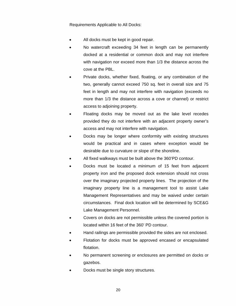
Requirements Applicable to All Docks:
All docks must be kept in good repair.
No watercraft exceeding 34 feet in length can be permanently
docked at a residential or common dock and may not interfere
with navigation nor exceed more than 1/3 the distance across the
cove at the PBL.
Private docks, whether fixed, floating, or any combination of the
two, generally cannot exceed 750 sq. feet in overall size and 75
feet in length and may not interfere with navigation (exceeds no
more than 1/3 the distance across a cove or channel) or restrict
access to adjoining property.
Floating docks may be moved out as the lake level recedes
provided they do not interfere with an adjacent property owner’s
access and may not interfere with navigation.
Docks may be longer where conformity with existing structures
would be practical and in cases where exception would be
desirable due to curvature or slope of the shoreline.
All fixed walkways must be built above the 360’PD contour.
Docks must be located a minimum of 15 feet from adjacent
property iron and the proposed dock extension should not cross
over the imaginary projected property lines. The projection of the
imaginary property line is a management tool to assist Lake
Management Representatives and may be waived under certain
circumstances. Final dock location will be determined by SCE&G
Lake Management Personnel.
Covers on docks are not permissible unless the covered portion is
located within 16 feet of the 360’ PD contour.
Hand railings are permissible provided the sides are not enclosed.
Flotation for docks must be approved encased or encapsulated
flotation.
No permanent screening or enclosures are permitted on docks or
gazebos.
Docks must be single story structures.
20

Docks may be allowed in intermittent ESAs at limited locations per
the discretion of SCE&G Lake Management Department. Docks
are prohibited in continuous ESAs.
All docks must be at least 50 feet from an ESA, unless otherwise
approved by SCE&G.
21

Figure 7-1: Typical Layout of Individual Docks on Easement Properties
22

Figure 7-2: Typical Layout of Individual Docks on Pre-2007 Future Development Properties
23

Figure 7-3: Typical Layout of Individual Docks on Post-2007 Future Development Properties
24

Figure 7-4: Permanent Structures for Individual Docks on Post-2007 Future Development Properties
25

26
7.2.2 Private Common Docks
Common docks are encouraged and may be mandated in certain
circumstances as an alternative to individual docks. A common dock may be
permitted for any two adjacent residential lots. On Easement and Pre-2007
SCE&G owned future development properties, each property owner participating
in a common dock must have a minimum of 75 feet along the 360’ PD contour or
75-ft buffer zone. On Post-2007 SCE&G owned future development properties
each property owner must own 150’ along the SCE&G buffer zone. Private
common docks shall follow all of the guidelines described for private individual
docks. Examples of common dock layout are provided in Figure 7-5, Figure 7-6,
Figure 7-7 and Figure 7-8.

Figure 7-5: Example of Common Dock Layout on Easement Properties
27

Figure 7-6 Example of Common Dock Layout on Pre-2007 Future Development Properties
28

Figure 7-7: Example of Common Dock Layout on Post-2007 Future Development Properties
29
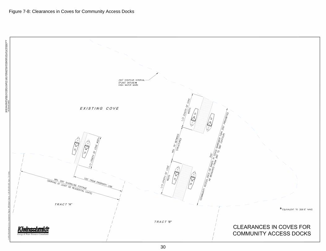
Figure 7-8: Clearances in Coves for Community Access Docks
30

31
7.2.3 Community Access Areas – Boat Ramps and Courtesy Docks
A community access area consists of a boat ramp and courtesy dock
open to property owners within a lakeside development who have deeded lake
access. General requirements for a community access development are as
follows and depicted in Figure 7-9, Figure 7-10 and Figure 7-11.
Initial consultation and site inspection by a SCE&G Lake
Management representative is required for development of
community access areas.
Existing slope and water depth must accommodate any ramp and
dock at a minimum lake level elevation of 352’ PD.
Qualification for a Community Boat Ramp will be heavily
influenced by evaluations of any necessitated impact to existing
trees and other vegetation.
Lots qualifying for a community access area must have a
minimum width of 100 ft along the 360’ PD contour or 75 ft buffer
zone, whichever applies.
Community access areas serving more than 50
property/residential units must have an additional 1.5 feet of linear
shoreline per additional property/residential unit served.
Community access areas must be located within the confines of
the proposed development with a minimum of 100 feet to the
nearest adjoining property, or a buildable lot designated on both
sides of the community area with a minimum linear shoreline
footage of 100 feet.
SCE&G requires a letter from the County Zoning Administration
stating that the proposed site location meets existing county
regulations to construct a community boat ramp or courtesy dock.
Ramps will be constructed of reinforced concrete and may
generally not exceed 12 feet wide.
Parking areas and turnarounds cannot be located in SCE&G
buffer zones, i.e., they must be located above the 75-ft buffer
zone. On easement property, a minimum of 50’ must be

established between the parking area and the 360’ PD contour.
For buffer zone restrictions see Section 2.1.3 of this document.
Community access areas serving 10 or fewer property/residential
units will meet the established general guidelines for docks,
generally permitted up to 750 square feet in size and 75 feet in
length. Community access areas serving more than 10
property/residential units may be eligible for a slip dock (see
Figure 7-1 for a diagram of a slip dock).
No destruction or removal of critical shoreline vegetation growing
below the 360' PD contour will be permitted for the installation of a
boat ramp or dock. Critical vegetation includes, but is not limited
to: button bush, willows, and significant hardwood species (consult
with SCE&G Lake Management and see Section 7.14 for
information on critical vegetation).
Courtesy docks are only allowed in coves or along waterways that
are at least 200 feet wide, measured from the 360’ PD contour of
the shore to the 360' PD contour of the opposite shore. Clearance
between structures on opposing banks may not exceed 1/3 the
distance across the waterway.
All community access docks are approved for short-term day use
only. No overnight docking will be allowed.
Final placement of all docks is at the discretion of SCE&G Lake
Management Department.
32

Figure 7-9: Example of Community Boat Ramp and Courtesy Dock on Easement Properties
33

Figure 7-10: Example of Community Boat Ramp and Courtesy Dock on Pre-2007 Future Development Properties
34

Figure 7-11: Example of Community Boat Ramp and Courtesy Dock on Post-2007 Future Development Properties
35

36
7.2.4 Private Multi-Slip (Inclusive of Private Boating Clubs)
In lieu of individual docks, multi-slip docks may be permitted based on
shoreline footage and other factors (Figure 7-12, Figure 7-13, Figure 7-14 and
Figure 7-15). SCE&G requires the developer to establish a homeowner’s
association to administer the neighborhood multi-slip dock program. Private land
owners owning property down to the 360’ PD contour (i.e., easement property
owners) may voluntarily establish ‘Greenspaces’ along the shoreline. Because
lands sold from the Future Development classification will already have a 75-ft
buffer zone associated with them, the concept of Greenspaces does not apply.
Greenspaces established by Easement property owners are undeveloped
lands that have been set aside and maintained as naturally vegetated areas.
The Greenspace must be deeded to the homeowner’s association. SCE&G
encourages the homeowner’s association to create an environmental
stewardship committee within the homeowner’s association to help monitor the
Greenspace. A Greenspace Plan must be prepared and submitted to SCE&G
and the plan should be consistent with SCE&G’s buffer zone management
guidelines (see Section 2.1.3). The presence of Greenspace is used to help
determine eligibility for multi-slip development.
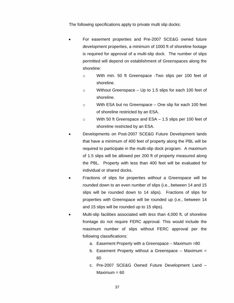
The following specifications apply to private multi slip docks:
For easement properties and Pre-2007 SCE&G owned future
development properties, a minimum of 1000 ft of shoreline footage
is required for approval of a multi-slip dock. The number of slips
permitted will depend on establishment of Greenspaces along the
shoreline:
o With min. 50 ft Greenspace -Two slips per 100 feet of
shoreline.
o Without Greenspace – Up to 1.5 slips for each 100 feet of
shoreline.
o With ESA but no Greenspace – One slip for each 100 feet
of shoreline restricted by an ESA.
o With 50 ft Greenspace and ESA – 1.5 slips per 100 feet of
shoreline restricted by an ESA.
Developments on Post-2007 SCE&G Future Development lands
that have a minimum of 400 feet of property along the PBL will be
required to participate in the multi-slip dock program. A maximum
of 1.5 slips will be allowed per 200 ft of property measured along
the PBL. Property with less than 400 feet will be evaluated for
individual or shared docks.
Fractions of slips for properties without a Greenspace will be
rounded down to an even number of slips (i.e., between 14 and 15
slips will be rounded down to 14 slips). Fractions of slips for
properties with Greenspace will be rounded up (i.e., between 14
and 15 slips will be rounded up to 15 slips).
Multi-slip facilities associated with less than 4,000 ft. of shoreline
frontage do not require FERC approval. This would include the
maximum number of slips without FERC approval per the
following classifications:
a. Easement Property with a Greenspace – Maximum =80
b. Easement Property without a Greenspace – Maximum =
60
c. Pre-2007 SCE&G Owned Future Development Land –
Maximum = 60
37

d. Post-2007 SCE&G Owned Future Development Land –
Maximum = 36
No individual dock will be permitted within a multi-slip dock
development.
The outside edge of all multi-slip docks at the 360’ PD contour line
must be a minimum of 150 feet from the nearest common property
line (e.g., adjoining properties), and meet minimum county zoning
requirements; whichever provides for greater distance. Docks
may not extend more than 1/3 the distance across a cove or
channel, as measured from the 360’ PD contour of one shore to
the 360’ PD contour of the opposite shore.
Access to multi-slip docks must be provided by the developer.
A narrow, meandering access path may be allowed in the
Greenspace and should be identified in the Greenspace
Landscape Plan.
Multi-slip dock facilities that accommodate watercraft with marine
sanitation facilities will be required to install, operate, and maintain
sewer pump-out disposal systems in accordance with State
regulations.
Final placement of the multi-slip facility will be subject to SCE&G
Lake Management approval.
38

Figure 7-12: Example of Multi-slip Dock Layout on Easement Properties
39

Figure 7-13: Example of Multi-slip Dock Layout on Pre-2007 Future Development Properties
40

Figure 7-14: Example of Multi-slip Dock Layout on Post-2007 Future Development Properties
41

Figure 7-15: Allowable Multi-slips on Easement Properties – with and without Greenspaces
42

43
7.2.5 Commercial Public Marinas (Inclusive of Public Boating Clubs)
A Commercial Public Marina is a facility that provides non-discriminatory
access for the general public to boat launching facilities, multi-slip docks (i.e. wet
storage), dry storage, food, gas, restrooms and/or other amenities, for a fee. A
commercial public marina must be independent from any off water development
with no reserved docking rights designated for any particular development.
The development and expansion of new or existing commercial docks
that are open to the general public for profit will be negotiated on a case-by-case
basis. Each permit request will be submitted for review and comment to a Lake
Murray commercial public Marina Review Committee (MRC). The MRC is made
up of county, state, regional, and federal agency representatives in addition to
SCE&G representatives. In addition to the MRC, there shall be a marina
advisory committee (MAC) with membership appropriate to represent the
residential, commercial, and other non-governmental interests of lakeside
property owners. Before any determination by the MRC is made, the plan will be
sent to the MAC and their input will be considered. The MAC will have a
maximum of 30 days to review and provide input to the MRC. The MRC will
have a maximum of 30 days after receiving comments from the MAC to provide
comments on the plan. Final approval by SCE&G is required for all marina
projects before approval is requested from the Federal Energy Regulatory
Commission (FERC).
It is advised that applicants for development of a commercial public marina
contact the SCE&G's Lake Management Department for an initial consultation
early in the planning stage. In addition to FERC, other federal as well as state
agencies have regulatory jurisdiction or resource management responsibilities with
regard to the waters and shoreline of Lake Murray. Each agency’s specific
requirement(s) must be satisfied as a prerequisite to permit issuance for a
commercial public marina. A commercial public marina applicant bears all
responsibility for determining fully what governmental and other requirements
beyond SCE&G’s permit are required. Opinions expressed or statements made by
SCE&G personnel cannot create a waiver as to any governmental requirements.
Applicants are responsible for all legal and administrative costs associated with
SCE&G’s preparation of the FERC filing.

An example of the agencies and their role in permitting and regulating
development of a commercial public marina is provided in Table 7-1 as
reference.
Table 7-1: Agency’s Involved in Permitting Process for Commercial Public Marina
AGENCY CONTACT INFORMATION REQUIREMENT
County Zoning Administration
(Dependent on county) Letter certifying that marina site location and activity proposed do not conflict with existing zoning regulations
U. S. Army Corps of Engineers (COE)
69A Hagood Ave.
Charleston, S.C. 29403-5107
(843) 329-8100
Section 10 Navigable Waters Permit2
Section 404 of Clean Water Act
S. C. Department of Health and Environmental Control (DHEC)
2600 Bull Street
Columbia, S.C. 29201
(803) 898-3300
401 Clean Water Certificate
State Navigable Waters Permit
S. C. Department of Natural Resources (SCDNR)
Rembert C. Dennis Building 1000 Assembly Street, Columbia, SC 29201
(803)-734-9100
Commenting Resource Agency in state and federal permitting processes
State Historic Preservation Office (SHPO)
South Carolina Department of Archives and History
P. O. Box 11669
Columbia, SC 29211
(803)-896-6178
Commenting Resource Agency in state and federal permitting processes
U.S. Fish and Wildlife Service (USFWS)
176 Croghan Spur Road, Suite 200
Charleston, SC 29407
(843)-727-4707
Commenting Resource Agency in state and federal permitting processes
SCE&G Lake Management Department
Columbia, SC 29218
(803) 217-9221
Issues/Denies Permit
2 After submittal of a joint application form by an applicant, the COE and DHEC will issue joint public notices in their
coordinated permitting processes through which each makes its own permit decision.
44

AGENCY CONTACT INFORMATION REQUIREMENT
Federal Energy Regulatory Commission (FERC)
888 First Street, NE
Washington, DC 20426
1-866-208-3372
Approves/Denies proposed commercial public marina based on application submitted by SCE&G
Additional governmental permits or authorizations may be required depending on particular circumstances of project.
General requirements for a commercial public marina vary depending on
the size or the facility, or the number of watercraft it accommodates. Facility size
has been categorized as those supporting (1) 20 or fewer watercraft (Figure
7-16), (2) 21-100 watercraft (Figure 7-17), or (3) 101 to 250 watercraft (Figure
7-18). A maximum development limit of two hundred fifty (250) on-water slips to
accommodate watercraft will be permitted. All marina facilities must comply with
all local, county, state, and federal regulations. Construction must commence
within one year from the date of the SCE&G permit. The build out period must
conform to the ACOE, FERC and DHEC permit conditions, and such additional
constraints as may be contained in the FERC Order approving SCE&G’s
issuance of a permit. The following sections provide the required specifications
for each facility size.
7.2.5.1 Commercial Public Marinas Accommodating Twenty (20) or Fewer
Watercraft (Figure 7-16)
Except when involving a peninsula (see following bullet item), no
commercial public marina accommodating twenty (20) or fewer
watercraft at a time will be permitted any closer than ¼ mile from
(i.e. within a ¼ mile radius of) an existing facility.
A commercial public marina proposed to be located at a site within
the ¼ or ½ mile radius of an existing facility, but separated by a
peninsula from the existing facility on the opposite side of the
peninsula, will be required to have a minimum linear shoreline
distance along the 360’ PD contour of 2 miles between the
existing and the proposed public marina.
No commercial public marina accommodating twenty (20) or fewer
docks may encroach or extend more than one-third of the distance
across the cove or waterway. Distance will be measured from the
360’ PD contour to 360’ PD contour, and will be determined on a
45
case-by-case basis.
No dock at a commercial public marina accommodating twenty
(20) or fewer watercraft may extend more than 175 feet lake-ward
from the 360’ PD contour high water mark or one third distance
across the cove whichever is less (Figure 7-19).
Commercial public marinas accommodating twenty (20) or fewer
watercraft at a time may not be located at a point in a cove or on
another waterway area having a distance from shore to shore of
less than 400 feet, measured from the 360’ PD contour on one
side to the 360’ PD contour across the cove or waterway on the
other side. They must be located or constructed such that the
docks and watercraft will not unduly restrict or limit navigation
through the area or access to adjoining properties.
Commercial Multi-slip dock facilities that accommodate watercraft
with marine sanitation facilities will be required to install, operate,
and maintain sewer pump-out disposal systems in accordance
with State regulations.
Commercial Multi-slip docks will not be permitted to have covers
or roofs over the docks or slips. Walkways may be covered as
long as they are above the 360’ PD contour line.
No multi-slip dock may encroach within 50 feet of a Natural Area
or identified ESA, as determined by SCE&G.
Final placement of all marinas is determined by the MRC and
must be approved by SCE&G.
7.2.5.2 Commercial Public Marinas Accommodating Twenty One to One
Hundred (21 - 100) Watercraft (Figure 7-17)
Except when involving a peninsula (see following bullet), no
commercial public marina accommodating twenty-one to one
hundred (21 - 100) watercraft at a time will be permitted any closer
than ½ mile radius from an existing Public Marina.
Any commercial public marina facility proposed to be located
within a ¼ or ½ mile radius of an existing marina, but separated by
a peninsula, and which will be located on the opposite side of the
peninsula, will be required to have a minimum linear shoreline
46

distance of 2 miles along the 360’ PD contour between the
existing and the proposed commercial public marina.
Commercial public marinas accommodating twenty-one to one
hundred (21 - 100) watercraft at a time must have a minimum of
800 feet of shoreline and be located or constructed in such a way
that the docks and watercraft will not unduly restrict or limit
navigation in the area or encroach within 150 feet of adjoining
properties.
No dock at a commercial public marina accommodating twenty-
one to one hundred (21 - 100) watercraft, may extend more than
300 feet lake-ward from the 360’ PD contour high water mark or
more than ⅓ the distance across the cove.
Commercial public marinas accommodating twenty-one to one
hundred (21 - 100) watercraft at a time must be located in areas
where water depths are adequate for boating access and may not
be located at a point in a cove or on another waterway area
having a distance from shore to shore of less than 900 feet,
measured from the 360’ PD contour on one side to the 360’ PD
contour across the cove or waterway on the other side.
Commercial Multi-slip dock facilities that accommodate watercraft
with marine sanitation facilities will be required to install, operate,
and maintain sewer pump-out disposal systems in accordance
with State regulations.
No commercial public marinas will be permitted to have covers or
roofs over the docks or slips below the . Walkways may be
covered as long as they are above the 360’ PD contour line.
No commercial public marinas may encroach within 50 feet of a
Natural Area or identified ESA as determined by SCE&G.
Final placement of all marinas is determined by the MRC and
must be approved by SCE&G.
Applicants will be required to perform a Baseline Environmental
Water Quality Monitoring Plan and conduct such water quality
sampling as required therein annually for five years during the
month of August.
47

7.2.5.3 Commercial Public Marinas Accommodating One Hundred One to
Two Hundred Fifty (101 - 250) Watercraft (Figure 7-18)
No commercial public marina facility accommodating one hundred
one to two hundred fifty (101 - 250) watercraft at a time will be
permitted any closer than ½ mile radius to an existing Public
Marina facility.
Any commercial public marina facility proposed to be located
within the ¼ or ½ mile radius of an existing facility, but separated
by a peninsula, must be located on the opposite side of the
peninsula, and must have a minimum linear shoreline distance
along the 360’ PD contour of 2 miles between the existing and the
proposed facility.
Commercial public marinas accommodating one hundred one to
two hundred fifty (101 - 250) watercraft at a time must have a
minimum of 1000 feet of shoreline and be located or constructed
in such a way that the docks and watercraft will not unduly restrict
or limit navigation in the area or encroach within 200 feet of
adjoining properties.
No dock at a commercial public marina accommodating one
hundred and one to two hundred-fifty (101 - 250) watercraft, may
extend more than 400 feet lake-ward from the 360’ PD contour or
more than 1/3 the distance across any cove.
Commercial public marinas accommodating one hundred one to
two hundred fifty (101 - 250) watercraft must be located in areas
where water depths are adequate for boating access and may not
be located at a point in a cove or on another waterway area
having a distance from shore to shore of less than 1000 feet,
measured from the 360’ PD contours of both shores.
Commercial public marinas that accommodate watercraft with
marine sanitation facilities will be required to install, operate, and
maintain sewer pump-out disposal systems in accordance with
State regulations.
No commercial public marinas will be permitted to have covers or
roofs over the docks or slips. Walkways may be covered as long
as they are above the 360’ PD contour line.
48

No commercial public marinas may encroach within 50 feet of a
Natural Area or identified ESA as determined by SCE&G.
Final placement of all marinas is determined by the MRC and
must be approved by SCE&G.
Applicants will be required to perform a Baseline Environmental
Water Quality Monitoring Plan and conduct such water quality
sampling as required therein annually for five years during the
month of August.
7.2.5.4 Additional Specifications for all Public Marinas
Marinas permitted for commercial use after 2007 cannot be
converted to private multi-slip use without re-applying for a new
permit from SCE&G and must comply with private marina
permitting policies.
The proposed commercial public marina should be located within
the confines of the imaginary projected property lines as they
extend lake-ward.
Excavations for commercial public marina facilities to improve
public access is discouraged but may be considered on a case-
by-case basis with consultation with SCE&G, and appropriate
state and federal resource agencies and regulatory authorities.
Commercial public marina facilities must at a minimum provide
public restrooms, and are encouraged to provide public fishing
access areas.
The applicant must sign and complete the Commercial Public
Marina Application Agreement before SCE&G will process a
permit request.
Existing marinas may remodel, rebuild, or repair within their
existing footprint with the approval of the appropriate local, state,
and federal agencies. To avoid additional permitting
requirements, the facility would need to maintain or reduce the
number of slips originally permitted.
Additions to existing marinas that increase the number of slips or
expand the existing footprint of the facility will require a permit for
the additional slips.
49

Expansion projects of existing marinas are evaluated on a case-
by-case basis and must go through the MRC. SCE&G will have
final approval of all projects.
If damage to an existing marina caused by storm or other natural
events requires maintenance and repair, the work completed on
the facility must comply with the original permit conditions and
specifications, and is not required to meet new standards.
50

Figure 7-16: Potential Layout for Commercial Marina Facility Accommodating 20 or Fewer Watercraft
51

Figure 7-17: Potential Layout for Commercial Marina Facility Accommodating 21 to 100 Watercraft
52
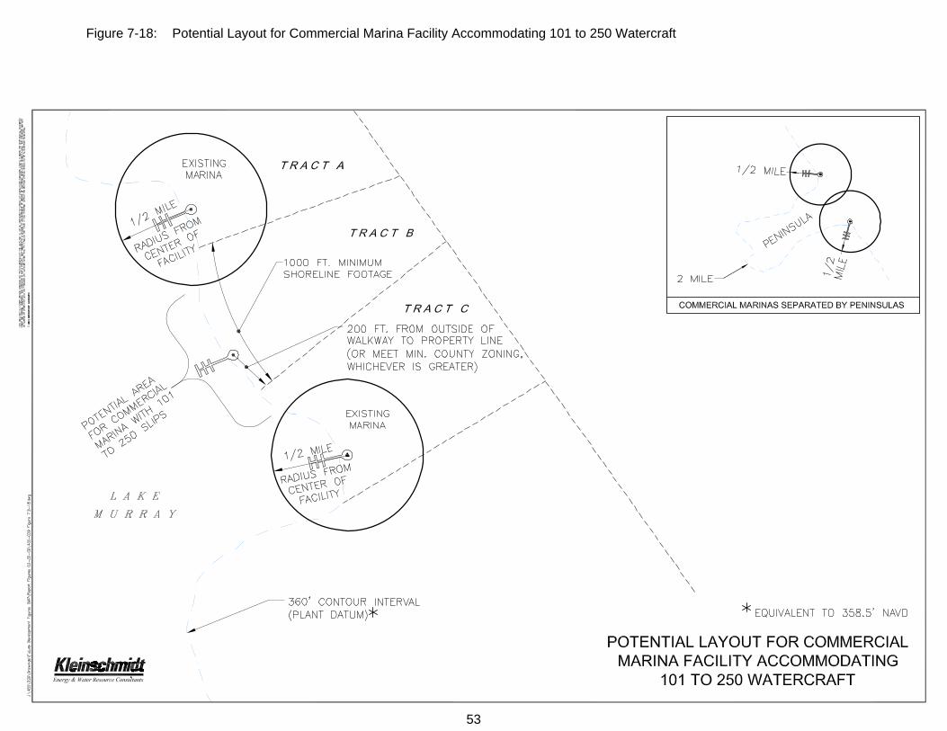
Figure 7-18: Potential Layout for Commercial Marina Facility Accommodating 101 to 250 Watercraft
53

Figure 7-19: Maximum Encroachment Distances in Coves for Commercial Marina Facilities
54

55
7.2.6 Watercraft Limitations
No watercraft exceeding 34 feet in length will be allowed to permanently
dock at a residential or common dock. Watercraft exceeding 34 feet must be
docked at a commercial public marina or multi-slip facility with pump-out facilities.
7.2.7 Dock Modifications
Prior to initiating any project, property owners should contact SCE&G’s
Lake Management Department at 803-217-9221. Dock modifications that may
temporarily or permanently affect the land or water of the shoreline require
submittal of a permit application to SCE&G and approval of the application prior
to the commencement of any such modifications. However, general
maintenance and repairs of docks such as replacing boards, etc. does not
require permitting. Dock owners must contact SCE&G’s Lake Management
Department for more information and guidance regarding the need for a permit to
conduct dock work.
7.2.8 Dock Policy on Forest Management Property
The SCE&G Forest Management Classification identifies SCE&G
timberlands located within the (PBL) Project Boundary line of the Lake Murray
Saluda Hydro Project. The Forest Management Classification property will not
be available for sale and is protected from shoreline (dock/ramp) development.
The timber is managed under the S. C. Forestry Commission (BMP) Best
Management Practices with restriction of any timber harvesting within 100 feet of
the high water mark (360 contour).
SCE&G has approximately 100 miles of shoreline and 3,570 acres
classified as Forest Management property around Lake Murray. The majority of
the Forest Management property is located in the upper western end of the
project along the Big and Little Saluda Rivers.

The Forest Management Classification has been in effect since 1979
when SCE&G was ordered by the (FERC) Federal Energy Regulatory
Commission to establish a Land Use Shoreline Management Plan for the Saluda
Hydro Electric Project.
The land being identified as Forest Management Property was protected
from shoreline development by prohibiting the sale of any available lands within
the PBL that were identified under the Forest Management Classification.
Over the years many property owners with land adjoining the SCE&G
shoreline property identified as Forest Management, have expressed concerns of
the restriction of no docks within the Forest Management Classification. Many of
the current property owners are family members of the original property owners
from whom SCE&G purchased their land for the development of the Lake. The
majority of the Forest Management Properties were originally timber, pasture,
and farm lands and have not changed very much over the years. This policy
would address the possibility of permitting some type of limited dock access
within the Forest Management Classification to existing back property owners
who could meet the established criteria for dock approval.
Requirements:
Individual Residential Dock
Eligibility for dock consideration restricted to property owners of
record as of January 1, 2007. SCE&G has County documentation
for property ownership for Newberry, Saluda, Lexington, and
Richland Counties.
Only one residential dock will be permitted for each identified tract
of land.
To be eligible for a dock, the property must first have a minimum
of 500 feet on the Project Boundary Line (PBL).
No dock will be permitted in narrow coves or shallow water areas
or areas identified as Environmental Sensitive Area (ESA).
56

A minimum width of 100 feet from the 360 contour must be
established prior to dock approval. If the PBL is less than 100 feet
the property owner would be required to deed SCE&G enough of
their property to create a minimum 100 foot Buffer Zone to qualify
for a dock. This buffer area will remain in the Forest Management
classification.
Dock site selection will typically be located in close proximity to
the narrowest distance from the 360 contour and being a minimum
of 100 feet.
A single residential access path, approximately 10 feet wide, may
be cleared for access to a permitted dock from the adjacent back
property owner’s land. The access path must follow a meandering
route to prevent erosion and to protect the aesthetics of the
shoreline. No trees larger than 8 inches diameter at breast height
can be removed within the 10 foot access path. No removal or
clearing of trees or vegetation cover within the Forest
Management Property will be permitted, with the exception of the
permitted access path.
Be advised that any unauthorized removal of trees or vegetation
on SCE&G property will result in the immediate cancellation of the
dock.
Each permit will be evaluated on a case- by-case basis with final
approval at the sole discretion of the SCE&G Lake Management
Department.
No docks will be permitted on the SCE&G Forest Management
Land located on the Big Saluda River above Kempson Bridge on
Hwy 395. This area, identified as the headwater of Lake Murray,
has significant environmental, ecological, and aesthetic values
that warrant protection.
57
7.3 Boat Ramps
SCE&G encourages the use of boat ramps at public facilities versus construction
of private ramps. Moreover, individual private boat ramps are not permitted in SCE&G
buffer zones. In cases where private boat ramps are permitted by SCE&G, the following
specifications apply to boat ramp construction:
Ramps may generally be up to 12 feet wide and the required length to be
functional at various water levels. Public ramps may be granted a
variance from these conditions.
Ramps must be constructed of concrete. Asphalt compounds or
petroleum based products are prohibited.
All ramps should be located so as not to interfere with neighboring
property owners. Adjoining shoreline property owners may agree to
common use of the ramp. The permit reflecting an agreement between
the two participating shoreline property owners will be provided by
SCE&G.
If a community access ramp is permitted, individual ramps will not be
permitted.
7.4 Boat Lifts
Boat lifts require a permit from SCE&G. The following specifications apply to the
construction of boat lifts:
All boat lifts must adjoin the owner’s dock. Pilings cannot extend beyond
the lakeward end of the dock.
Boat lifts should be located so as not to interfere with the adjacent
property owners’ access.
Only one boat lift will be approved per individual dock. On a case by case
basis SCE&G Lake Management Department will consider 2 boat lifts for
a common dock that is shared by two property owners.
No covers are to be constructed over boatlifts.
All boat lifts are to be low profile style lifts.
58

7.5 Personal Watercraft Lifts
Personal Watercraft lifts will require a permit from SCE&G. Facilities for lifting up
to two personal watercrafts may be permitted per dock. The following specifications
apply to the construction of personal watercraft lifts:
Personal watercraft lifts should be located so as not to interfere with the
adjoining property owners’ access; and
No covers are to be constructed over personal watercraft lifts.
7.6 Marine Railways
Marine railways require a permit from SCE&G with the following specifications:
Marine railways are permitted for access to the lake from facilities located
above the 360’ PD contour; and
Railways constructed below the 360’ PD contour area are restricted to no
more than two-foot elevation above the natural lake basin.
7.7 Floating Platforms or Tubes and Other Water Toys
These items are not allowed to be permanently installed and must be
removed before sunset each day; and
These items must not inhibit navigation or extend more than 1/3 the width
of the cove at the high water mark (360’ PD contour).
7.8 Water Removal
7.8.1 Residential Withdrawals
Residential requests for water withdrawals require a permit from SCE&G.
Water removal permits for residential property will be for irrigation purposes only. All
irrigation pumps and wiring must be located behind the 360’ PD contour. Combustion or
diesel pumps will not be permitted. SCE&G reserves the right to prohibit irrigation during
times of drought or low water conditions. Applicants should contact the SCE&G Lake
Management Department for permit applications and additional information.
59

7.8.2 Commercial Withdrawals
Commercial/Municipal request for water withdrawals require a permit from
SCE&G. SCE&G may authorize water withdrawals up to 1 MGD without the
requirement of FERC approval. SCE&G will impose limits (such as pump size or pipe
size) in granting permits for approved applications. The applicant will be required to
compensate SCE&G for water withdrawn and to bear expenses of filing the application.
A commercial application to withdraw water from the lake must include the
following information:
a complete description of the purpose for the removal;
removal processes to be used;
volumes to be withdrawn;
copies of all required local, state, and federal permits and reports;
the required fee; and
any additional information as required by SCE&G.
7.9 Erosion Control (Shoreline Stabilization)
All shoreline stabilization efforts, including construction or repair of rip-rap,
seawalls, retaining walls, and bioengineering, must be approved in writing by SCE&G
Lake Management prior to implementation and/or construction. Furthermore, there are
some areas of the lake where facilities may not be permitted because of environmental
considerations, development patterns, physical lake characteristics, impacts to cultural
resources, or other reasons.
Property owners should be aware that conducting any shoreline stabilization
activities at a federally licensed hydroelectric project (e.g., Saluda Hydroelectric Project,
FERC Project No. P-516) is a privilege that can only be granted with authorization from
the Licensee. Because every possible situation cannot be anticipated, SCE&G Lake
Management reserves the right to make special rulings in cases not specifically covered
by these guidelines. Shoreline stabilization projects must adhere to the following
specifications.
60

General Requirements:
Silt fencing must be properly installed on the 360’ PD contour or buffer
zone, where applicable, before any land disturbance activities take place.
The applicant must be the owner of the tract of land immediately adjoining
the high water mark (360’ PD contour) or SCE&G-owned buffer zone, or
have the written permission of the easement property owner on water
rights tracts (e.g., where SCE&G only has a flowage easement).
SCE&G Lake Management will hold the applicant fully responsible for
ongoing adherence with the current SMP and Handbook, including
maintaining structures in good repair. This responsibility transfers
automatically along with ownership.
Prior to beginning any activity/construction within the high water mark
(360’ PD contour), the applicant must obtain all necessary governmental
permits or approvals, and written authorization from SCE&G Lake
Management.
Consultation with SCDNR and U.S. Fish and Wildlife Service (USFWS)
will be required for stabilization that exceeds 500 linear feet of shoreline.
In order to protect aquatic resources, shoreline stabilization activities shall
typically be performed September through February. In emergency
situations, for repairs necessary to ensure integrity of existing structures,
work may be performed outside September-February time period upon
approval by SCE&G.
The applicant shall make every reasonable effort to minimize any adverse
impact(s) on fish, wildlife, shoreline vegetation, and other natural
resources.
New or expanding stabilization activities (excluding bio-engineering) may
not be undertaken within a 50-foot offset from an ESA classification as
identified in the SMP. All shoreline stabilization activities affecting an
ESA will be assessed on a case-by-case basis.
Minimal clearing below the high water mark (360’ PD contour) may be
allowed to create corridors for equipment access for stabilization projects.
Access corridors should be incorporated into fixed pier/dock access
corridors (i.e. foot paths) where practical. Vegetation removed to
61
accommodate construction access for shoreline stabilization shall be
replaced with native vegetation.
Shoreline stabilization activities are limited to the eroded bank. Any
unavoidable impacts to existing emergent aquatic vegetation, as a result
of stabilization installation, require the replanting of vegetation in the
impacted area(s).
Bio-Engineering Stabilization is a preferred shoreline stabilization
technique and is encouraged, especially in eroded areas associated with
emergent aquatic vegetation. Applicants are encouraged to avoid
activities (including stabilization) that could have an adverse impact(s)
upon existing native aquatic plants.
Approved bioengineering techniques are generally required for eroded
banks of two feet or less of erosional scarp. Approved bioengineering
and/or vegetated riprap techniques are preferred for eroded banks
exceeding two feet of erosional scarp.
The type of plantings utilized in bioengineering and landscape-planting
projects should be native to South Carolina, and must be reviewed and
approved by SCE&G Lake Management prior to introduction. Desirable
species include grasses such as switchgrass and maidencane, and shrub
and saplings such as water willow, black willow, button bush, and river
birch.
Riprap stabilization installed below the high water mark (360’ PD contour)
in vegetated areas must be limited to one layer deep to allow spaces
between the stone for vegetation recruitment.
Riprap material must be SCDOT Class B, or larger, quarry-run stone,
natural stone, or other material approved by SCE&G. The use of tires,
scrap metal, crushed block, construction/demolition debris, or other such
types of material, is not allowed.
Riprap use should be limited to only that area necessary to adequately
stabilize the existing eroded bank. Riprap should be confined to a linear
distance of 6 feet below the high water mark (360’ PD contour) except
where the entire placement is on/above severely eroded banks. These
areas must be sloped back or terraced to provide maximum bank stability.
An example of shoreline rip-rap detail is shown in Figure 7-20.
62

Stabilization of eroded banks that are 2 feet in height or higher, or that are
not associated with emergent aquatic vegetation, can be stabilized using
SCDOT Class B or larger size riprap with filter cloth, bio-engineering
using significant live staking and planting, or other forms of bio-
engineering within the riprap.
Retaining wall stabilization is only allowed for erosion control where the
average eroded bank height is greater than 3 feet and the wall is
constructed at the high water mark (360’ PD contour). Earth fills below
the high water mark (360’ PD contour) are prohibited.
A layer of rip-rap (SCDOT Class B or larger) extending 6 feet lake-ward
from the high water mark (360’ PD contour) must be placed along the
entire base of all retaining walls. The 6-foot requirement is measured
horizontally as shown on Figure 7-201.
No sand shall be placed below the 360’ PD contour. Effective measures
must be used to keep sand from migrating below the 360’ PD contour.
63
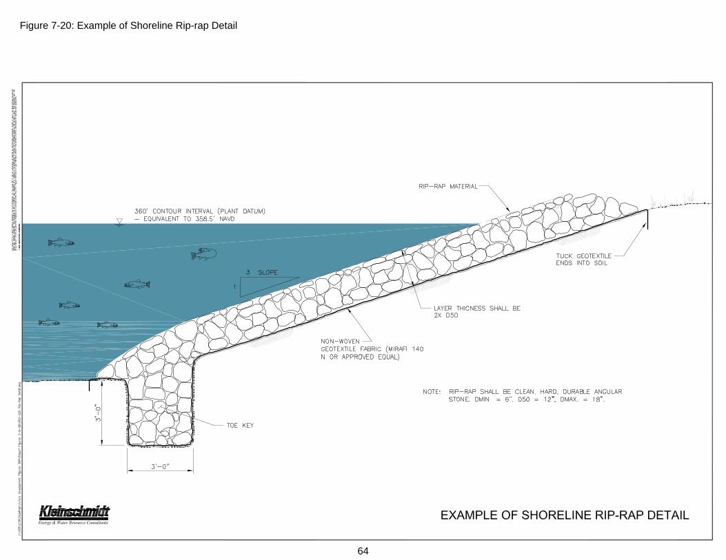
Figure 7-20: Example of Shoreline Rip-rap Detail
64

Figure 7-21: General Guidance for Typical Shoreline Stabilization Retaining Wall
65

66
7.10 Excavation Activities
Excavation activities below the 360’ PD contour are discouraged. Excavating of
soils can release erodable earth material into the environment if precautions are not
taken. SCE&G monitors excavation activities by requiring that a permit be obtained from
SCE&G for work performed below the 360’ PD contour. All authorized excavations must
be in accordance with SCE&G specifications and requirements, which may include an
environmental assessment plan or report. Figure 7-22 depicts general guidance for
excavations. Any permitted excavation work must meet the following specifications:
SCE&G Lake Management Department must be notified prior to
commencement and upon completion of work.
All displaced soil must be taken off site or otherwise stabilized above the
360’ PD contour in accordance with SCE&G requirements if in Richland,
Saluda and Newberry Counties, and in accordance with
recommendations of the Lexington County Sediment Control
Representative if in Lexington County.
A maximum of 150 cubic yards of soil will be allowed
A 4 to 1 slope is the maximum slope allowed.
All excavating must be done directly in front of the applicant's property
unless the adjoining property owner signs off on the project, or unless
otherwise approved by SCE&G in consultation with SCDNR.
All excavations must occur below the 354’ PD contour, unless otherwise
approved by SCE&G in consultation with SCDNR.
No excavation will be permitted in a wooded or vegetated area, within 50
feet of an ESA, or other areas that may be identified by SCE&G in
consultation with SCDNR. The protection of shallow water habitat must
be considered at all times. A Lake Management representative will
designate the area to be excavated.
Excavation activities generally will not be allowed between January 15
and October 1. Exceptions may be granted by SCE&G based on
hydrological or meteorological conditions. Permits are valid for only one
(1) year from the date of issue. See date on approved permit.
Water must not cover the excavation site during excavation activities.

The contractor must have a copy of the approved permit and drawing
while on the job site at all times.
All excavation should be completed by using the following equipment: (1)
dragline; (2) track backhoe; (3) bulldozer; or other equipment approved by
Lake Management personnel.
67

Figure 7-22: Guidance for Excavations
68

69
7.11 Prohibited Activities/Structures
The following activities/structures are prohibited below the 360’ PD contour or in
the 75-ft buffer zone on Lake Murray. These prohibitions will be enforced by SCE&G or
an appropriate state or federal agency:
Encroachments: no sand or earth fill encroachments. Any unauthorized
earth fill or structures that occurred prior to January 1, 1974, will be
handled on a case-by-case basis.
No fixed or land-based structures (boathouses, storage buildings,
shelters, patios, brick barbeques, fences, swimming pools, satellite dish,
signs, dog pens or invisible fencing, boat storage).
No seawalls or retaining walls.
No fences.
No septic tanks and/or drain fields.
No planting of grass except as a permitted erosion control measure.
No storage or stockpiling of construction material.
No vegetation removal of any type except in a permitted 10-foot wide
access path to the shoreline.
No limbing or trimming or cutting of Buffer Zone vegetation to create
views or visual corridors.
No fires or overnight camping (buffer zone only). All fires must conform to
federal, state, and county burning ordinances.
No unauthorized removal of trees or vegetation.
Unless specifically authorized by the Lake Management Department, no
all-terrain vehicles (ATV’s), motorcycles, golf carts, or off road vehicles
are allowed.
No roofs or covers over any dock unless the dock is within 16 feet of the
360’ PD contour.
No roofs or covers over any boat lifts.
No fueling facilities permitted on dock.
No permanent mooring.
No water craft exceeding 34 feet in length will be permitted to be
permanently docked at a private dock. Docking for more than 14 days in
any consecutive 30-day period is considered to be permanent.

No excavation/dredging above the 354’ PD contour or in shallow water
habitat and ESA’s.
No effluent discharges, such as sinks, showers, toilets, etc.
No drive-on docks unless it is taking the place of the traditional floating
dock that is made of wood and is no larger than 12’X 20’.
Permanent screening or enclosures will not be allowed on fixed seating
areas of docks or gazebos.
No upland (located above the 360’ PD contour) water gardens (e.g. fish
ponds, waterfalls, etc.) will be permitted to drain into the lake.
No spraying of herbicides into the waters of Lake Murray or onto property
where the herbicides may end up in Lake Murray.
Dock lighting should be focused downward and should not intrude on
adjacent property owners, or impact navigation.
7.12 Environmentally Sensitive Area (ESA) Restrictions
The following activities/structures are prohibited in Environmentally Sensitive
Areas (ESAs). These prohibitions will be enforced by SCE&G or an appropriate state or
federal agency:
SCE&G prohibits clearing of vegetation within ESAs or within associated
buffer.
Commercial public marina facilities must be located a minimum of 50 feet
from an ESA.
New or expanding stabilization activities (excluding bio-engineering) may
not be undertaken within a 50-foot offset from an ESA classification. All
shoreline stabilization activities affecting an ESA will be assessed on a
case-by-case basis.
No excavation/dredging in ESAs or shallow water habitat.
Areas where intermittent ESAs have been identified may accommodate
limited docks, with approval from SCDNR and USFWS.
70

7.13 Access Path
Back property owners of land adjoining buffer zones are allowed access by foot
to and from the lake through the buffer zone. Creation of a single 10-foot wide access
trail that leads down to the lake may be permitted. To prevent erosion and to protect the
aesthetics of the shoreline the route should not be direct and instead will have a
meandering design. No trees larger than 8 inches in diameter at breast height (dbh) can
be removed within the access path. Paths must consist of approved materials such as:
woodchips, mulch, pine straw, pervious concrete with tinted color, fieldstone, river stone,
and native grasses. A Lake Management representative must identify and designate the
location of access paths.
7.14 Limited Brushing
For buffer zones established prior to 2007, limited brushing of the buffer zone by
the back property owner may be allowed to remove exotic, invasive, or other specified
vegetation. Permission for limited brushing will only be granted by SCE&G Lake
Management after a site visit with the applicant to assess the need for brushing. Once
limited brushing is completed according to the permit, the applicant shall maintain the
site in said condition.
In general, certain critical vegetation cannot be removed even when limited
brushing is permitted. Some species and types of vegetation provide important benefits
such as shoreline stabilization, water quality functions, habitat, shade in near shore
environments, and terrestrial input for aquatic ecosystems. For the purposes of a limited
brushing permit, the following vegetation cannot be cleared:
Black Gum Oak Sycamore Black Willow Persimmon Tag Alder Buttonbush River Birch Tulip Poplar
Cottonwood Water Hickory Certain hardwood
species Green Ash Wax Myrtle Dogwood
71

Plants that can be cleared through limited brushing generally are undesirable
species that are invasive and in some cases exotic. Included in this group are the
following:
Vines such as green briars, Japanese honey suckle, poison ivy, poison
oak, wisteria, and kudzu;
Shrubs such as black berry and privet;
Trees such as mimosa and Bradford Pear; and
Trees that are dead, diseased and create a hazard.
Some selective clearing of native, non-invasive species will be allowed through
limited brushing. Generally, this will include certain softwood species that are less than
3 inches diameter at breast height (dbh). Species that could be cleared in this category
include the following:
Loblolly Pine Red Maple Longleaf Pine Sweetgum Red Cedar Virginia Pine
Any vegetation that does not meet the above listed criteria, but that the back
property owner would still like removed, must be addressed individually with SCE&G
Lake Management Department. It is likely that any vegetation or tree removal that is not
consistent with limited brushing, as outlined above, will have to be mitigated and may
include revocation of the property owner’s dock permit.
7.15 Non-disturbance Areas
For buffer zones that are established after 2007, SCE&G will maintain a policy of
no-disturbance of vegetation. Limited brushing will not be allowed on these lands under
any circumstances. No vegetation below the 360’ PD contour may be removed without
prior approval from SCE&G. Only vegetation removal associated with creating a single
10-foot wide access trail leading to the lake is allowed. The desired vegetated condition
of non-disturbance areas is depicted in Figure 7-23, Figure 7-24, and Figure 7-25.
72
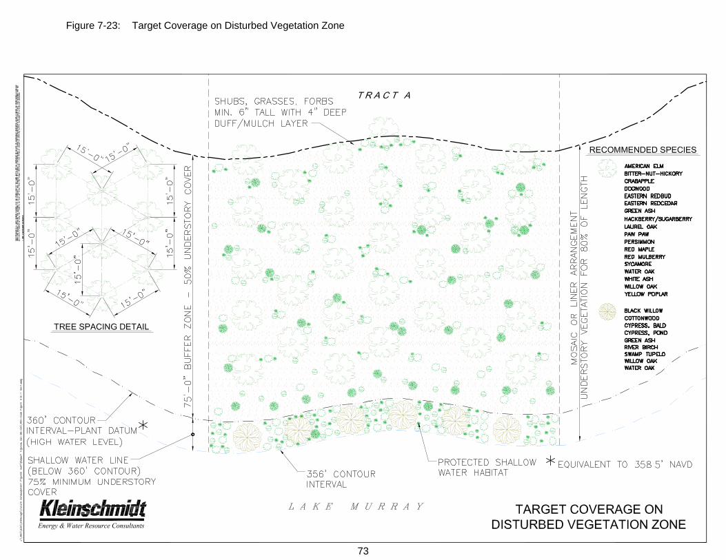
Figure 7-23: Target Coverage on Disturbed Vegetation Zone
73

Figure 7-24: Land Management Prescriptions for Future Development Properties - Minimum Vegetation Height and Tree Spacing
74

Figure 7-25: Target Coverage of Understory Vegetation
75

76
7.16 Woody Debris Management
Submerged and shoreline woody debris provides habitat for many species of
fish, macroinvertebrates, birds, reptiles, and mammals. This debris also helps protect
the shoreline from erosion. SCE&G maintains a policy of non-disturbance for any and all
woody debris unless its removal is necessary for reasons of health and human safety, or
the debris is so minimal that it is insignificant in the provision of fish or wildlife habitat.
Under some conditions, approval may be granted to remove woody material. SCE&G’s
woody debris management policy may allow the removal of woody debris below the 360’
PD contour if it poses a clear safety or navigation concern, is brought to the attention of
SCE&G’s Lake Management Department personnel and is approved by Lake
Management. Guidelines for the removal of woody debris are as follows:
7.16.1 Submerged Woody Debris
SCE&G’s Shoreline Management Plan allows limited removal of
shoreline vegetation necessary for the construction and
installation of docks and other permitted shoreline amenities.
Shoreline property owners must obtain permission from SCE&G
prior to removing shoreline woody debris below the 360’ PD
contour.
If a dock is proposed for an area that contains significant, stable
woody debris, SCE&G may propose an alternate location for the
dock or prohibit the dock altogether.
For tree stumps that pose a material threat to safety, landowners
may be allowed to cut them off to an appropriate level, depending
on expected water depth and proximity to docks and other activity-
related facilities.
7.16.2 Floating Woody Debris
Floating woody debris may be removed by SCE&G, SCDNR, or
any member of the boating public when encountered if it is
reasonably considered a material public safety issue or
impediment to navigation.
The debris should be removed from open water areas and taken
to the shoreline.
SCE&G encourages that it be secured onshore in undeveloped
areas, such as the backs of coves and/or undeveloped lands.
7.16.3 Shoreline Woody Debris
Shoreline woody debris is managed in a manner similar to submerged
woody debris:
Limited removal of shoreline woody debris may be permitted to
accommodate construction and installation of docks or other
permitted shoreline amenities.
Should a dock be proposed for an area that contains significant
shoreline woody debris, SCE&G may propose an alternate
location for the dock or prohibit the dock altogether.
Shoreline property owners must obtain permission from SCE&G to
remove shoreline woody debris below the 360’ PD contour.
Unauthorized removal of stable shoreline woody debris may result
in the cancellation of dock permits and/or other shoreline amenity
permits and a requirement that there be appropriate mitigation for
the improper woody debris removal.
Shoreline woody debris that may be a navigation hazard may be
removed.
7.17 Permitting Application Procedure
The applicant will be required to submit to SCE&G a completed application along
with the following:
A copy of applicant’s plat to the property reflecting county tax map
information.
Specific directions by land to applicant’s property on Lake Murray.
Sketch showing the location, design, and dimensions of the proposed
structure, or the type and location of erosion control proposed.
77

Excavation projects will require a drawing to scale of the area to be
excavated.
Applications for excavation not exceeding 150 cubic yards can be
processed by SCE&G Lake Management Department. Any commercial
excavation or individual excavation exceeding 150 cubic yards must also
be processed through the U. S. Army Corps of Engineers and state
agencies.
Commercial applications to withdraw water from the lake also must
include a complete description of the purpose for the removal and
processes to be used, the volumes to be withdrawn.
A permitting fee is required.
Required local, state and federal permits and/or reports. The Lake
Management Department will assist in the preparation of required local,
state and federal permit applications.
7.18 Permitting Fees
SCE&G charges individual processing fees for its efforts in managing various
permitting activities around the lakes. Permit fees are listed on the permit applications
and are due at the time of application submission to SCE&G. If an application is denied
the permit fee will be returned.
An annual Administrative Fee may be implemented, as FERC allows SCE&G the
right to charge a reasonable fee to cover the costs of administering its Shoreline
Permitting Program, which adds significant management responsibilities and costs to
SCE&G’s operation. SCE&G will give adequate public notice through appropriate
communication avenues before changing the fee structure. Failure to comply with this
policy may result in the revocation of existing permits, fines, or legal action, as well as
loss of consideration for future permits.
7.19 Violations
SCE&G conducts annual surveys of the lake shoreline to inventory and inspect
docks built and permitted throughout the year. Dock applicants are responsible for
maintaining their structures in good repair and safe condition. If at any time a dock is
determined by a SCE&G Lake Management representative to be in disrepair or a
78

hazardous condition, it must be repaired or removed from the Lake Murray waters
immediately. SCE&G reserves the right to remove any dock on its property as
conditions warrant.
SCE&G also makes note of unauthorized structures during its surveys, and urges
residents and other lake visitors to report what they believe may be unauthorized activity
below the 360’ PD contour and in the buffer zones. SCE&G Lake Management
representatives will issue Stop Work Directives for any violations that are detected on
SCE&G property. Any unauthorized clearing of the trees or underbrush will result in the
immediate cancellation of an individual’s dock permit as well as action to require re-
vegetation of the affected area. Removal of merchantable timber will require
reimbursement to SCE&G Company subject to valuation of the SCE&G Forestry
Operations Department. Additional, consequences for violations may include loss of
consideration for future permits, fines, and/or legal action.
7.20 Miscellaneous
Deeds, permits, or other instruments affecting Lake Murray lands and
waters will contain all standard covenants customarily imposed upon
project property and such other covenants as in the sole discretion of
SCE&G may be desirable or appropriate. The instrument may contain
indemnity clauses and insurance provisions.
Permitting fees do not constitute a charge for admission to Project lands.
SCE&G retains the right to vary the amount of application fees.
No vested right or rights enforceable by third parties are created by
SCE&G’s Policies or Procedures.
Maps of Lake Murray showing public and commercial landings, parks,
navigational markings, and other information are available free of charge from SCE&G.
Inquiries concerning policies, procedures, applications or regulations as outlined in this
booklet, or requests for maps or applications, should be directed to SCE&G:
South Carolina Electric & Gas Company
Lake Management Department
Columbia, South Carolina 29218
Telephone (803) 217-9221
79

South Carolina Electric & Gas Company
Lake Murray Management Department
Columbia, South Carolina 29218
Published 1-75
Revised 5-80
Revised 5-84
Revised 6-88
Revised 2-90
Revised 8-95
Revised 11-07
Revised 07-09