appendix b balmoral south iron ore project environmental ... · balmoral south iron ore project...
TRANSCRIPT

Appendix B
Balmoral South Iron Ore Project
Environmental Scoping Document

Balmoral South Iron Ore Project
Environmental Scoping Document
International Minerals Pty Ltd
September 2008

Balmoral South Iron Ore Project 2
Environmental Scoping Document
Balmoral South Iron Ore Project
Environmental Scoping Document
Prepared by
International Minerals Pty Ltd
September 2008
All rights reserved. No section or element of this document may be removed from this document, reproduced, electronically
stored or transmitted in any form without the written permission of IM Pty Ltd.

Balmoral South Iron Ore Project 1
Environmental Scoping Document
Table of Contents 1.0 PURPOSE OF DOCUMENT 3
2.0 PROPONENT AND STUDY TEAM 4
3.0 THE PROPOSAL 5
3.1 Proposal Overview 5
3.1.1 Related Environmental Approvals 6
3.1.2 Construction Activities 11
3.1.3 Operation Activities 11
3.1.4 Closure Activities 11
3.1.5 Key Project Characteristics and Technical Specifications 11
3.2 Description of Key Activities 13
3.2.1 Mine and Waste Storage 13
3.2.2 Processing Facilities 13
3.2.3 Materials Handling Facilities 14
3.2.4 Utilities 14
3.2.5 Project Infrastructure 15
3.3 Project Timeline 15
3.4 Project Justification 16
3.4.1 The World Market for Steel 16
3.4.2 State and National Benefits 16
3.5 Alternatives Considered 17
3.5.1 Introduction 17
3.5.2 Product Transport – Mine to Port 18
4.0 STAKEHOLDER CONSULTATION 19
5.0 SUMMARY DESCRIPTION OF THE PHYSICAL, BIOLOGICAL AND SOCIAL
ENVIRONMENT OF CAPE PRESTON 22
5.1 Climate 22
5.2 Air Quality 22
5.3 Geology and Groundwater 22
5.4 Hydrology 23
5.5 Flora and Vegetation 24
5.6 Phreatophytic Vegetation 24
5.7 Mangroves 25
5.8 Terrestrial Fauna 25
5.9 Subterranean Fauna 25
5.10 Marine Environment 26
5.11 Local Land Uses 28
5.12 Heritage 28
6.0 PRELIMINARY ENVIRONMENTAL IMPACT ASSESSMENT 30
6.1 Clearing Activities 30
6.2 Surface Water Management 31
6.3 Dewatering Activities 32
6.4 Atmospheric Emissions 33
6.5 Waste Management 34

Balmoral South Iron Ore Project Environmental Scoping Document
2
6.6 Noise Emissions 35
6.7 Adjacent Land Users 35
6.8 Recreational Activities 36
7.0 MATTERS OF NATIONAL ENVIRONMENTAL SIGNIFICANCE 37
8.0 ENVIRONMENTAL FACTORS, INVESTIGATIONS CONDUCTED TO DATE,
POTENTIAL MANAGEMENT AND PROPOSED STUDIES 38
9.0 CUMULATIVE IMPACT ASSESSMENT 50
9.1 Central Block and Balmoral South Iron Ore Projects 50
9.2 Mineralogy Proposed Projects 50
10.0 ENVIRONMENTAL MANAGEMENT STRUCTURE 52
11.0 APPLICABLE LEGISLATION 54
12.0 BIBLIOGRAPHY 57

Balmoral South Iron Ore Project 3
Environmental Scoping Document
1.0 PURPOSE OF DOCUMENT
International Minerals Pty. Ltd. (IM) proposes to develop a magnetite iron ore mine, processing facility
and associated infrastructure in the Cape Preston region of Western Australia, 80km south of
Karratha.
On 14 May 2007, the Environmental Protection Authority (EPA) released its recommendation to set
the level of assessment for the Balmoral South Iron Ore Project at Public Environmental Review
(PER).
This Environmental Scoping Document (ESD) has been prepared pursuant to section 6.1 of the
Environmental Assessment (Part IV Division 1) Administrative Procedures 2002, which outline the
requirements and approval procedures for an Environmental Scoping Document where the level of
assessment has been set at PER. This document identifies potential environmental impacts on
relevant environmental factors, summarises previous works undertaken relevant to the proposal and
outlines relevant studies and activities to be undertaken by the proponent to complete the PER.
The Department of Environment, Water, Heritage and the Arts (DEWHA) has determined that the
Balmoral South Iron Ore Project is a “controlled action” under the Environment Protection and
Biodiversity Act 1999 (EPBC Act). Balmoral South Iron Ore Project (EPBC ref 2008/4236) can be
assessed under the “Agreement between the Commonwealth of Australia and WA under Section 45 of
the EPBC Act relating to the Environmental Impact Assessment and in conformance with the
Cooperative Arrangement to the Bilateral”. This ESD has been prepared to also meet the
requirements of the DEWHA.
This proposal will require environmental approval from both the State and Commonwealth
environment ministers.

Balmoral South Iron Ore Project Environmental Scoping Document
4
2.0 PROPONENT AND STUDY TEAM
IM, a wholly owned subsidiary of Australasian Resources Limited „ARH‟ (ASX Code: ARH), is the
Proponent for the development of the Balmoral South Iron Ore Project.
The Proponent has entered into a series of agreements with Mineralogy Pty Ltd, which provide for the
rights and tenure to all of the Mineralogy tenements necessary to carry out the Balmoral South Iron
Ore Project. These agreements have been approved by the Minister for Resources Development and
are set out in the First Schedule of the Iron Ore Processing (Mineralogy Pty Ltd) Agreement Act 2002
which was passed by the Parliament of Western Australia in 2002.
Contact Details:
Nick Jukes
Study Director
International Minerals Pty. Ltd.
Email: [email protected]
Phone: 08 9322 2288
IM has been supported by the following groups and individuals:
URS Australia – preparation of the Environmental Scoping Study and Public Environmental Review, intertidal marine ecological assessment and hydrodynamic modelling;
Maunsell Australia and Bassett Acoustics – completion of terrestrial ecological surveys, noise impact assessment, air quality assessment, interpretation of baseline studies, assessment of outcomes in a local and regional context, development of management procedures and peer review;
SMEC Australia – assistance with the Environmental Scoping Document and peer review;
Aquaterra – completion of groundwater and surface water investigations, impact assessment and development of management strategies;
Benellongia – field investigations and reporting for subterranean fauna; and
Professor Brenton Knott – advice on subterranean fauna.

Balmoral South Iron Ore Project Environmental Scoping Document
5
3.0 THE PROPOSAL
3.1 Proposal Overview
The Balmoral South Iron Ore Project is adjacent to the Mineralogy Central Block Project (Central Block
Project) which has received environmental approval for the development of a mine, processing plant,
stockyards, villages, port, dredging and associated infrastructure (Ministerial Statement 635). The
Central Block Project is currently being developed by CITIC Pacific Mining Management Pty. Ltd.
(CPMM) under commercial agreements with Mineralogy.
Mineralogy is proposing to develop two further projects in the Cape Preston region. Mineralogy‟s
current development plan for the Cape Preston region is further detailed in the information provided in
Section 9.2, which highlights the context of these developments and relevance to the Balmoral South
Iron Ore Project.
This proposal for the IM Balmoral South Iron Ore Project is seeking approval for the areas shown in
“Figure 1 Balmoral South Iron Ore Project Areas of Disturbance Sheet 1 of 2” and “Figure 2 Balmoral
South Iron Ore Project Areas of Disturbance Sheet 2 of 2”.
The Central Block Project and its immediate surrounds were extensively assessed to support that
project‟s approvals. IM has built on this previous work through the completion of a number of specialist
studies to fill in the gaps in knowledge to complete an assessment of the cumulative impacts of the
Balmoral South Iron Ore and the Central Block Projects, refer to “Figure 3 Balmoral South Iron Ore
Project and Mineralogy Central Block Project Approved Areas of Disturbance Sheet 1 of 2” and
“Figure 4 Balmoral South Iron Ore Project and Mineralogy Central Block Project Approved Areas of
Disturbance Sheet 2 of 2”.
A suite of Environmental Management Plans (EMPs) have been prepared to satisfy the Ministerial
Conditions for the Central Block Project. IM recognises the important role that many Government
Departments have played in working with the Central Block proponent to develop these EMPs. The
EMPs set out the statutory requirements and industry best practice management strategies for an iron
ore mining and processing project in the Cape Preston region. IM proposes to adopt and, where
necessary, update the management strategies for the Central Block Project to ensure consistency in
environmental management for the region.
The Balmoral South Iron Ore Project is seeking approval for the establishment of:
Open pit mine;
Waste Dump Facitilies(WDF1 and WDF2);
Run of Mine (ROM) pad;
Processing Plant, including power station and pelletising plant;
Accommodation Village (Camp);
Service corridors and roads;
Conveyors, pipelines, power and gas distribution;
Desalination plant, including intake and outfall;
Buildings, workshops and associated infrastructure; and
Other infrastructure as required to support the project.

Balmoral South Iron Ore Project Environmental Scoping Document
6
3.1.1 Related Environmental Approvals
IM has access to additional infrastructure that is the subject of a separate approval application
including port facilities. The final location of the desalination plant intake and outfall of the Balmoral
South Iron Ore Project will be determined subject to the approvals granted to the port facilities of the
Central Block Project. From the IM stockyard facilities, product will be conveyed to the port which will
be established by the Central Block Project. From here product handling and loading will be managed
in conjunction with the Central Block Project.

Balmoral South Iron Ore Project 7
Environmental Scoping Document
Figure 1 Balmoral South Iron Ore Project Areas of Disturbance Sheet 1 of 2

Balmoral South Iron Ore Project 8
Environmental Scoping Document
Figure 2 Balmoral South Iron Ore Project Areas of Disturbance Sheet 2 of 2

Balmoral South Iron Ore Project Environmental Scoping Document
9
Figure 3 Balmoral South Iron Ore Project and Mineralogy Central Block Project Approved Areas of Disturbance Sheet 1 of 2

Balmoral South Iron Ore Project Environmental Scoping Document
10
Figure 4 Balmoral South Iron Ore Project and Mineralogy Central Block Project Approved Areas of Disturbance Sheet 2 of 2
Balmoral South Iron Ore Project 11
Environmental Scoping Document
3.1.2 Construction Activities
The construction period for the Balmoral South Iron Ore Project is expected to be approximately six
years. The following summarises the main construction activities:
clearing of the mine and infrastructure sites;
extraction of a bulk sample from the mine pit;
pre-strip of the open pit to expose ore in advance of processing plant operation;
construction of mining infrastructure;
construction of monitoring equipment and commencement of monitoring activities;
construction of temporary facilities (such as lay down areas, construction accommodation village (camps) and offices, workshops, concrete batching plant);
construction of crushing, concentrating and pelletising facilities;
construction of plant, roads, pipelines, conveyors, power station, communications and other services;
construction of permanent accommodation, stream diversions, building pads, waste dump facility (WDF), and waste management facilities;
construction of the desalination intake and wastewater outfall pipes; and
other construction activities associated with the above.
3.1.3 Operation Activities
In relation to the operation activities, the Balmoral South Iron Ore Project will operate for at least 25
years and the following summarises the main operation activities:
extraction of ore and waste for the mining operations;
movement and placement of waste ore/rock into WDFs;
operation of processing facilities (such as primary crusher, concentrator and pellet plant);
disposal of waste processing material (dewatered tailings) to WDFs;
operation of project infrastructure including power station and desalination plant;
transportation of finished products from process plant site to stockyard facilities at Cape Preston;
operation of desalination intake and wastewater outfall; and
processive rehabilitation of waste dump facilities
3.1.4 Closure Activities
The closure of the mine site would include the following tasks:
mine roads ripped and seeded;
removal of infrastructure such as above ground structures, pipelines, electrical reticulation and magazines;
creation of mine abandonment bunds as per DoIR guidelines;
rehabilitation of mine office and workshop site; and
removal of the fuel farm and clean up of any contaminated areas.
3.1.5 Key Project Characteristics and Technical Specifications
The following characteristics have been identified for the Balmoral South Iron Ore Project. Whilst
best endeavours will be taken to develop plant designs that conform to these specifications,
accurate quantities will not be known until detailed design is developed during later phases of the
project.

Balmoral South Iron Ore Project Environmental Scoping Document
12
Table 1 Key Project Characteristics
Element Characteristics
General
Construction period 6 years
Operation Period Minimum 25 years
Mining
Ore reserves 2 billion tonnes
Ore mining rate Around 80 Mtpa
Pit depth 300 m
Overburden and waste Around 80 Mtpa
Stripping ratio 1.0 / 1.0 waste ore
Materials handling Conventional drill, blast, load and haul
Dewatering rate Up to 4 GLpa
Dewatering disposal To process water stream and dust suppression
Concentrator
Production Ore concentration: 24 Mtpa
Waste 56 Mtpa
Pelletising
Production Pellets: 14 Mtpa
Infrastructure
Power Up to 600 MW installed capacity gas fired combined cycle power station
Conveyor ~ 30km in length between the Process Plant Site and Cape Preston
Stockyard
Gas supply Up to 34,000 TJ pa
Water Supply 40 GLpa desalination plant and up to 4 GLpa pit dewatering
Port Stockyard 2Mt storage capacity
Roads General traffic, haulage, mine, accommodation and access, infrastructure
maintenance access
Buildings Administration, maintenance workshops, storage, accommodation village
and power station
Sewage Package treatment plants
Approximate Disturbance Areas
Total Area of disturbance 6000 ha
Workforce
Construction Up to 4000
Permanent Up to 1500
Accommodation Onsite for the entire workforce

Balmoral South Iron Ore Project Environmental Scoping Document
13
3.2 Description of Key Activities
3.2.1 Mine and Waste Storage
The mining operations for the Balmoral South Iron Ore Project will involve large scale open-pit
magnetic iron ore extraction, including:
drilling;
blasting;
excavation;
loading;
truck haulage;
run of mine stockpiles;
ore delivery to processing facilities; and
waste disposal to WDFs.
The material will be blasted before loading. The mining rate is expected to be 160 Mtpa, comprising
80 Mtpa of ore and 80 Mtpa of waste for a minimum of 25 years. The amount of ore and waste
mined annually will vary according to the pit configuration at the time, ore quality and market
requirements, which may lead to mining rates exceeding those identified above. The ore will be
delivered to the crushers via trucks and / or conveyors. Crushing will occur before transport by
conveyor to the concentration plant. In-pit crushing is being examined as an option once the mine
has been established at depth.
Waste rock and dewatered tailings will be co-disposed in the designated waste dump facilities areas
(WDF1 to the west of the pit and WDF2 to the east of the pit)
The ultimate height of the WDFs is 90m above ground level constructed in 30m lifts.
The tails stream produced from processing magnetite ore consists of inert materials comprising a fine and coarse fraction. The tails will be dewatered and conveyed to the WDF‟s for storage in overhead bins prior to truck haulage to dispose of the tails in conjunction with waste rock or alternatively distribution by stacker.
The construction of the WDF‟s will be such as to shed as much surface water as possible to help reduce the potential for acid mine drainage (“AMD”).
A test work program has been commissioned to test the potential for acid formation from the waste material encountered within the pit of the Balmoral South Iron Ore project. The McCrae shale unit has been reported to have acid producing potential. It is not anticipated that significant quantities of McCrae shale will be mined, other than in isolated areas around faults. If any AMD waste is encountered it will be separately encapsulated in the WDF‟s, surrounded by low permeability material or blended with neutralising waste in accordance with DoIR and Environment Australia, 1997 guidelines.
The Pilbara region has the potential for asbestiform mineral occurrence. IM is working closely with the Central Block proponents to identify potential issues and has developed management plans for safe work procedures.
In the event that pyritic shales or asbestiform minerals are identified, the appropriate methods for managing the materials will be determined through consultation with the regulatory authorities.
3.2.2 Processing Facilities
Unlike high grade iron ores, magnetite ore requires beneficiation prior to export to steel mills. The
processing facilities for the Balmoral South Iron Ore Project will include:

Balmoral South Iron Ore Project Environmental Scoping Document
14
materials stockpiles;
primary and secondary crushing;
high pressure grinding rolls;
concentration via magnetic separation;
waste disposal; and
pelletising.
There will be various intermediate stockpiles within the plant.
The option chosen for the concentrator plant will use high pressure grinding rolls to reduce the ore
size. This will help to reduce both power and water requirements. Should engineering studies prove
that this is not viable, the Proponent will select conventional milling i.e. autogenous grinding. The
crushed ore will be slurried and concentrated by magnetic separation. Water from the coarse and
fine tailings produced in the concentrator will be recovered by filtering to minimise water usage. The
preferred option for the disposal of tails is to dewater the tailings which will then be transported to the
mine WDFs. Traditional tailings dams may be required if this process is not viable. However, this
option is not a part of this approval assessment.
In the pellet plant, the concentrate will be balled with an organic binder or bentonite, and dolomite or
limestone will be added to the pellets to meet physical specifications. The pellets will then be dried
and cooled through a Travelling Grate or Grate-Kiln pelletising process. Fines, pellet chips and
spillage will be captured and refed into the pellet plant.
3.2.3 Materials Handling Facilities
The material handling infrastructure required for the project includes:
conveyors; and
stockpiles including stackers and reclaimers.
Pellets and concentrate will be moved to the port stockyard by up to two conveyors. 14 Mtpa of
pellets and 10.4 Mtpa of concentrate will be conveyed. From the stockyard, the pellets and
concentrate will be conveyed to the port. Roads will be required to manage inbound and outbound
logistics other than finished products.
3.2.4 Utilities
Given the remote location and lack of existing infrastructure, the project requires utilities to support
the construction and operation including:
desalination plant for process and potable water supply;
sewage treatment plants; and
combined cycle power plant.
Water will be required for ore processing and potable water will be required for the mine, plant and
accommodation village (camp) areas. A 40 GLpa desalination plant is proposed and forms part of
this assessment.
Package treatment plants will treat sewage effluent from on-site amenities. Treated water from this
process will be used for irrigation where appropriate.
A combined cycle gas-fired power station will be constructed adjacent to the concentrator / pellet
plant complex to supply up to 450 MW of power for the project. With standby capacity, the size of
the installed power station will be up to 600 MW.
Gas for the power station will be transported via a spur line connecting to the Central Block Project
gas lateral.

Balmoral South Iron Ore Project Environmental Scoping Document
15
3.2.5 Project Infrastructure
Project infrastructure required includes:
4,000 person construction accommodation village;
1500 person permanent village;
services corridors;
on-site roads, power transmission lines and water piping;
mobile equipment workshops (service and maintenance);
specialist workshops (electrical, boilermaker, crusher);
medical and emergency response facilities;
wash bay / tyre bay / fuel bay for mining and support vehicle fleets;
laboratory;
explosives magazines and storage and distribution depot;
offices (administration, mine planning, process plant, maintenance);
crib room facilities (mine planning, production, maintenance);
warehousing; and
other ancillary requirements necessary for the project.
Roads will be required to manage inbound and outbound logistics other than finished products.
During the construction period, a workforce of up to 4,000 people will be housed in camp style units
on-site. Once no longer required, the accommodation village will be downsized to accommodate an
operations workforce of up to 1500 permanent employees. Other temporary facilities such as
construction roads, offices and batch plant will also be removed and the affected areas either
rehabilitated or maintained for future lay-down as appropriate.
A services corridor will be constructed between the accommodation village and the approved
services corridor for the Central Block Project. This corridor will be 300 m wide and will be located
within the eastern edge of the mining leases M08/123 to M08/130 and the western edge of G08/63
and 100m wide within the southern edge of M08/130. Conveyors, access roads, utilities / services
and other infrastructure will be constructed within this corridor.
This application also seeks to widen the eastern port access corridor to 300m (90m currently
approved for the Central Block Project) and construct an additional western corridor to 250m wide.
These corridors will provide access for conveyors, access roads, railway lines, utilities/services and
other infrastructure. The corridor will also cater for 3rd Party access as required by Clause 6(5) of
the Iron Ore Processing (Mineralogy Pty. Ltd.) Agreement Act 2002.
A landfill will be located and maintained for inert and perishable waste. The location of this landfill is
yet to be determined, but it will be situated and operated to meet all safety, health and environmental
requirements.
3.3 Project Timeline
The Balmoral South Iron Ore Project is expected to operate for at least 25 years, although
extensions beyond this will depend on continued contracts for ore supply and economic analysis.
It is proposed to develop the Balmoral South Iron Ore Project in two stages as described in Table 2.

Balmoral South Iron Ore Project Environmental Scoping Document
16
Table 2 Two Stages of the development of Balmoral South Iron Ore Project
Stage Timing Product
Pellets Concentrate Export Product
(Pellets and Concentrate)
1 Within three years of project commencement
7 Mtpa 5.2 Mtpa 12.2 Mtpa
2 Within six years of project
commencement
7 Mtpa 5.2 Mtpa 12.2 Mtpa
Total six years of project
14 Mtpa 10.4 Mtpa 24.4 Mtpa
During Stage 1 of operations, magnetite concentrate will be produced at the process plant at a rate of 12 Mtpa. Of this, 6.8Mtpa would be used in pellet production. With the addition of binders, a total of 7 Mtpa of pellets would be produced. Approximately 5.2Mtpa of concentrate remains available for export, along with the 7.0 Mtpa of pellets. Stage 1 is scheduled to be exporting concentrate and pellets within three years from commencement of project construction. The facilities will be expanded on completion of Stage 1 to suit the output of the mine and plant. Stage 2 is scheduled to commence three years after the start of project construction.
3.4 Project Justification
Balmoral South Iron Ore Project will use an ore resource which is undervalued by current operators
in the Pilbara, and could eventually lead to significantly more development in terms of support
industries, other port users and offshore gas fields.
3.4.1 The World Market for Steel
In 2005, the world production of steel was 1.1 Bt, an increase of 5.8% from the previous year. In
2006 the international steel market continued with strong growth driven by strong demand. The
international steel price rose throughout 2006 and continues to rise in 2008. This continued rise in
prices has been spurred by global economic growth. There has been high demand growth in the
USA, EU, Japan and China, while at the same time, there was a reduction of crude steel production
in many countries. Consequently, the world market experienced a shortage in supply, resulting in
price rises.
3.4.2 State and National Benefits
Australia‟s balance of payments will improve through the production of value-added minerals that
would otherwise not to be exported.
The benefits to Western Australia include:
expenditure of up to AU$5 billion dollars for the project;
increased royalties from the sale of additional iron ore products;
increased employment and training opportunities;

Balmoral South Iron Ore Project Environmental Scoping Document
17
encouragement in the growth of ancillary industries in WA;
increased use of natural gas derived from local gas fields and indirect value-adding to that natural resource tapped locally; and
additional infrastructure development.
Benefits to the local region will include:
provision of direct business, employment and training opportunities for the communities in the Pilbara during the construction and operation phases; and
economic multiplier effects to other local businesses
The „no project‟ option would result in the compounding of a number of undesirable issues which
have been recognised in Australia‟s minerals extraction industry, namely:
loss of employment and training opportunities to overseas suppliers and downstream processors;
the inability to improve export earnings from the natural resources extracted;
loss of a new industry together with the associated developments and ancillary industries that would flourish in support.
3.5 Alternatives Considered
3.5.1 Introduction
As part of the approvals process for the Central Block Project a number of alternatives were
considered for the location of project components, including a port. These can be divided into three
alternatives:
construction of the concentrator at the mine site (a feature common to all three alternatives due to the need to dispose of a large quantity of tailings), slurry or rail transport of the concentrate to a site near the Burrup Peninsula (e.g. West Intercourse Island, South West Burrup, Hearson Cove, Maitland Estate) for pelletising, and export via a port constructed on the Burrup Peninsula (e.g. West Intercourse Island, King Bay, South-West Burrup);
construction of the processing plant at the mine site with the rail of finished product to the Burrup Peninsula for stockpiling and export via a port constructed at one of the above locations; and
construction of the processing plant at the mine site and construction of a port at Cape Preston. (Initial investigations also evaluated the option of locating the processing plant site at Cape Preston. However, the southern site was selected since it provides a significant area of flat ground)
The above alternatives were considered against a number of criteria including:
environmental – shorter transport distance will result in less land clearing and less greenhouse gas emissions;
plant economics – costs of building the facility at a location remote from a population centre (Karratha) compared with operational savings associated with having an integrated project with all of the downstream processing components located in close proximity to each other. There would also be additional costs associated with building a power station at one location and having to transmit power to a second location 100 km away, and the power loss such transmission would involve;
economics of materials handling – 25-30 km of product transport to Cape Preston versus 100 km to the Burrup Peninsula; and
capacity for expansion – sufficient area exists adjacent to the mine site for further downstream processing and at the port site for further materials stockpiles and construction of berths to allow the export of different products
The above considerations have been taken into account for the development of the Balmoral South
Iron Ore Project.

Balmoral South Iron Ore Project Environmental Scoping Document
18
3.5.2 Product Transport – Mine to Port
Four options were considered for the transport of finished products from the mine site to Cape
Preston:
rail haulage;
road haulage
slurry pipeline; and
conveyor
A conveyor provides the most practical solution for pellets. Slurry pipeline and a dewatering plant at
the port may be used for the transportation of concentrates.
From an environmental perspective a conveyor or slurry pipeline are preferred due to the smaller
area that will need to be disturbed to allow construction and operation. They will also result in fewer
greenhouse gas emissions per tonne of material moved compared to road and rail transport.

Balmoral South Iron Ore Project Environmental Scoping Document
19
4.0 STAKEHOLDER CONSULTATION
A community and stakeholder consultation process has occurred over seven years (2000 – 2008) to
document the issues associated with industrial development in the Cape Preston region. IM has
undertaken specific stakeholder consultation on the environmental impacts associated with the
Balmoral South Iron Ore Project. A project specific targeted consultation process has been
developed to ensure that as many key stakeholders as possible are informed, with an opportunity to
comment and provide technical guidance on the development plans.
The proponent conducted stakeholder consultation for the Balmoral South Iron Ore project during
October 2006. Through DoIR, the Office of Development Approval Coordination provided the
Proponent with a list of potential key stakeholders, to whom a project discussion paper was
distributed. Written responses were requested and a meeting with all respondents was held in early
November 2006. Additional meetings with key Decision Making Authority „s (DMA‟s), including DEC,
EPA and DoW have been conducted to help refine the potential significant issues on site and ensure
baseline studies address those issues.
In August 2007 IM undertook a supplementary consultation program posting consultation packages
to 52 groups, including:
key government Ministers, agencies and regional branches;
the Shire of Roebourne (Local Government Authority);
non-government organisations that represent indigenous interests, conservation and recreation groups and industry bodies;
community groups; and
local business groups
In March 2008, IM sent a further consultation package to keep stakeholders informed on the
development of the project and a project amendment to increase the production of concentrate from
12 Mtpa to 24 Mtpa.
To assist with the input from stakeholders into the consultation process, IM provided a “Project
Overview for Key Stakeholders” document within the packages to introduce the project concept to
stakeholders and later consult with them on issues and potential impacts. The document provided:
a description of the proposal;
an overview of project benefits;
a summary of environmental impacts; and
Proponent‟s Environmental Commitments
IM also attached a pro-forma table to help guide stakeholder feedback based on specific
environmental impacts identified. Currently feedback has been received from more than 30
representatives via letter, email, phone calls and meetings.
Key issues identified through the consultation process are summarised in Table 3.
Consultation with stakeholders will continue through the environmental approvals process and throughout the life of the project.

Balmoral South Iron Ore Project 20
Environmental Scoping Document
Table 3 Summary of key issues identified
Factor Issues Stakeholders
Terrestrial Flora and Vegetation
Declared Plants issues need to be considered in consultation with Department of Agriculture and Food (e.g. Mesquite) DEC, DAF
Need to consider conservation status of regionally significant native vegetation DEC
Need to consider local and regional significance of impacting groundwater dependent vegetation DEC, DOW
Project should address Conservation, Recreation and Natural Landscapes Reserve over Mangrove Creek and coastal zone adjacent to Stockpiles.
Shire of Roebourne
Subterranean Fauna
Need to provide supporting documents and consult experts on stygofauna and troglofauna. DEC, DOW
Matters of National Significance
identify the project's potential impacts on turtle nesting from lighting, construction works, loss of foraging habitat, increased recreational movement including camping and potential boat strike from increased boating activity
DEWHA
identify the project's potential impacts on the marine environment, particularly seagrasses, from the chemical and temperature characteristics of the discharge from outlets. (Scientific data suggests that increased salinity will adversely affect the health of seagrass beds). Potential impacts on the Dugong from potential loss of feeding habitat and from increased boating activity
DEWHA
Surface Water
Strategies to minimise impact, including increased erosion and sedimentation. DOW, DOIR
Modelling to include the cumulative impacts of the Balmoral South Iron Ore and Central Block Projects. DOW
Provide the methodology for hydraulic modelling DOW
Detail the impact of the changes to the groundwater and surface water interactions as a result of the project. DOW
Groundwater
Consider the cumulative impacts across the total area of the proposed development. DOW
Details of monitoring programs, trigger levels, mitigation measures and contingency plans. DOW, DEC
Monitoring should cover saline intrusion from the ocean as a gradient is created towards the mine pit. DOW
Consider hydro-geological conditions such as connectivity between aquifers. DEC
Water Quality
Describe management of surface water quality during construction and operation. DOW
Potential impacts of predicted rising sea levels and the risk of storm surge during cyclonic events. DOW, DEC

Balmoral South Iron Ore Project Environmental Scoping Document
21
Factor Issues Stakeholders
Flooding
Need to ensure diversion channels are designed to accommodate the peak flood event during the life of the project. DoIR
Describe the impact from the peak flood event with a map showing the increase in area. DOW
Assess sedimentation in the Fortescue River as a result of the waste dump and tailings facility impeding flood flows. DEC, DoIR
Demonstrate that the plant, power station and other infrastructure are protected from flooding during major flows. DOW, DOH
Water Supply
Demonstrate the site water balance, water supplies and water use efficiency measures including improvement targets. The project needs to look at alternative water supplies and develop contingency planning.
DOW, DOH, Industry groups
Wastewater
Wastewater treatment and disposal systems. DOH, DOW
Emission
Need to consider the cumulative impacts associated with air emissions DEC,DOH, DPI
Noise
Address the impacts of noise and vibration on fauna. DEC
Address prediction of blasting noise levels. DEC
Heritage
Resolve Aboriginal heritage issues including additional surveys, ongoing consultation and staff heritage awareness DEC, DIA, Local Aboriginal groups
Social Impact
Workforce planning such as transport and transit requirements for construction and operation of this project. MRWA, DOH, Shire of Roebourne
Impacts on grazing lands and Pastoral Lease including: devaluation of Lease, jeopardising sale of Lease, direct loss of grazing land, loss of tourism potential, contamination affecting grazing land, loss of water supplies, road kills, dust impacts and loss of access.
Pastoral Lease Holder
Recreation
Management of impact on public usage of publicly accessible land in the area. Shire of Roebourne, DPI
Need to consider Conservation Estate (e.g. Great Sandy Island Nature Reserve, parts of Mardie and Karratha Stations to be relinquished, proposed Dampier Archipelago Marine Park and Cape Preston Marine Management Area).
DoE(CALM), Marine and Parks Reserves Selection Working Group

Balmoral South Iron Ore Project 22
Environmental Scoping Document
5.0 SUMMARY DESCRIPTION OF THE PHYSICAL, BIOLOGICAL AND SOCIAL ENVIRONMENT OF CAPE PRESTON
The Balmoral South Iron Ore Project is located on the north-west Pilbara coast near the mouth of the
Fortescue River on weed infested cattle grazing country. The Cape Preston Region is affected by
cyclones and associated flood events.
5.1 Climate
The Pilbara region is characterised by a hot arid climate, with daily maximum temperatures at Mardie
ranging from 28°C to 38°C, daily minimum temperatures ranging from 12°C to 25°C and an annual
rainfall of about 270 mm. Occasional heavy rainfall events occur as the result of cyclone activity.
5.2 Air Quality
Cape Preston is a remote site, relatively far from existing emission sources. As a result, existing levels of SO2 and NO2 are low. Ozone levels are moderate as indicated in the DEP monitoring at Dampier, where, over two years of monitoring, two events with 1-hour concentrations exceeding 0.06 ppm or 60% of the NEPM standard were recorded. These were due to bushfire smoke and, as such, similar levels could be expected at Cape Preston.
NOX levels are also low with data indicating that the background annual average is around 3 μg/m3
with a 70th percentile 1-hour concentration of 5 μg/m3. Average annual background (concentrations at
areas with no local sources) PM10 values in the Port Hedland region are around 20 μg/m3.
5.3 Geology and Groundwater
The eastern part of the area is characterised by two series of north-northeasterly trending ridges of
outcropping Lower Proterozoic aged rocks of the Mount Bruce Supergroup, which are part of the
Hamersley Basin. The western series of ridges are made up of banded iron formation (BIF), cherts,
shales and breccias of the Brockman Iron Formation. A schematic geological section through the
project area is presented in Figure 5.

Balmoral South Iron Ore Project 23
Environmental Scoping Document
Figure 5 Schematic geological cross section
Three main orebodies have been identified; the George Palmer (Central Block) Orebody and the
Northern and Southern Blocks. The orebodies are high-grade magnetites that have developed within
the Joffre Member of the Brockman Iron Formation. A thin veneer of Quaternary aged alluvial,
colluvial and residual soils overlies the basement rocks in low lying areas, with some creek bed
alluvium along drainage courses.
The major aquifers in the area are the gravels of the Fortescue River alluvium and to a lesser extent
the Yarraloola Conglomerate. The alluvium is potentially a major source of fresh water and could
support substantial pumping. Hydraulic conductivity values in excess of 50 m/d and individual bore
yields up to 900 kL/d have been demonstrated. Sustainable abstraction of around 10,000 ML per year
has been estimated and the Department of Water has ear-marked the aquifer system as a potential
area for future development. Numerous station wells and bores in the area also tap this aquifer.
Depth to the watertable over the full project area is generally 4 m to 12 m below ground level. The
groundwater quality within the project area varies from fresh (<1,000 mg/L TDS) in the central part of
the alluvium along the main channels of the river, to brackish (1,000 - 2,000 mg/L TDS) in basement
rocks and on the edge of the floodplain, and brackish to saline (>5,000 mg/L TDS) near the coast.
5.4 Hydrology
The mine site is located adjacent to the lower reaches of the Fortescue River and about 15 km from
the river mouth to the Indian Ocean. Above the project area, the Fortescue River has an effective
catchment area of approximately 20,000 km2 and an estimated 100 year ARI peak flow of 9,570 m³/s.
The Fortescue River has a well defined main flow channel, typically 4-6 m deep and around 100 m

Balmoral South Iron Ore Project Environmental Scoping Document
24
wide adjacent to the project area. The main channel has a gravelly bed and typically gum trees along
both banks. Vegetation over the floodplains varies from wide open grass areas to dense scrub.
Du Boulay Creek flows in a north-westerly direction through the general project area, and joins the
Fortescue River approximately 6 km from the coast. The creek has a catchment area of about
200 km2, with an estimated 100 year ARI peak flow of 1,400 m³/s. Du Boulay Creek typically has main
flow channels with 5-10 m width gravel beds and trees along the banks. Floodplains adjacent to the
main channels typically comprise open grassed areas with scattered trees.
5.5 Flora and Vegetation
The Balmoral South Iron Ore Project Area is situated within the Fortescue Botanical District of the Pilbara region and broadly consists of various Acacia Shrublands over Triodia Hummock Grasslands on the more rugged, shallow soiled habitats and Eragrostis xerophila Tussock Grasslands dominating the heavy clay soils. Drainage lines are dominated by Eucalyptus species over Melaleuca and Acacia Shrublands.
83 vegetation communities have been identified in the project area. No Threatened Ecological Communities have been recorded. Of particular importance are the cracking clays of the Horseflats Land System and the phreatophytic vegetation of the River and Paraburdoo Land Systems.
Within the entire Cape Preston project area a total of 500 vascular flora species, from 64 families and 196 genera has been recorded. This total includes 482 (96.4%) native species and 18 (3.6%) introduced (weed) or non-endemic species. Families with the highest representation were Poaceae (Grass family – 73 native taxa; 4 introduced taxa); Papilionaceae (Pea family – 44 native taxa); and the Malvaceae (Mallow Family – 49 native taxa, 2 introduced taxa).
Ten Priority flora species have been identified through DEC Threatened and Priority Flora database searches to potentially occur within the project area. Of these, four were recorded within the mining lease during field surveys conducted between 2000 and 2007. Of those four species, Eriachne tenuiculmis and Sida sp. Wittenoom (WR Barker 1962) both formerly P3 have recently been removed from the DECs Threatened and Priority Flora List (2008). Two additional Priority Flora species, Goodenia sp. East Pilbara (A.A Mitchell PRP 727) and Phyllanthus aridus were not listed on the DEC database but have been found within the project area during field surveys.
No Declared Rare Flora (DRF) pursuant to the Wildlife Conservation Act 1950, or Threatened Flora pursuant to the Environment Protection and Biodiversity Conservation Act 1999 (EPBC Act) have been recorded within the project area.
The project area contains the Declared Plants Prosopis pallida (Mesquite) and Datura leichhardtii (Native Thornapple). Drainage lines also tend to be heavily infested with Cenchrus ciliaris (Buffel Grass), a highly invasive weed introduced by pastoralists for its grazing value.
5.6 Phreatophytic Vegetation
Three phreatophytic species occur within the project area:
Eucalyptus camaldulensis;
Eucalyptus victrix; and
Melaleuca argentea.
These species make up eight phreatophytic vegetation communities.
Balmoral South Iron Ore Project Environmental Scoping Document
25
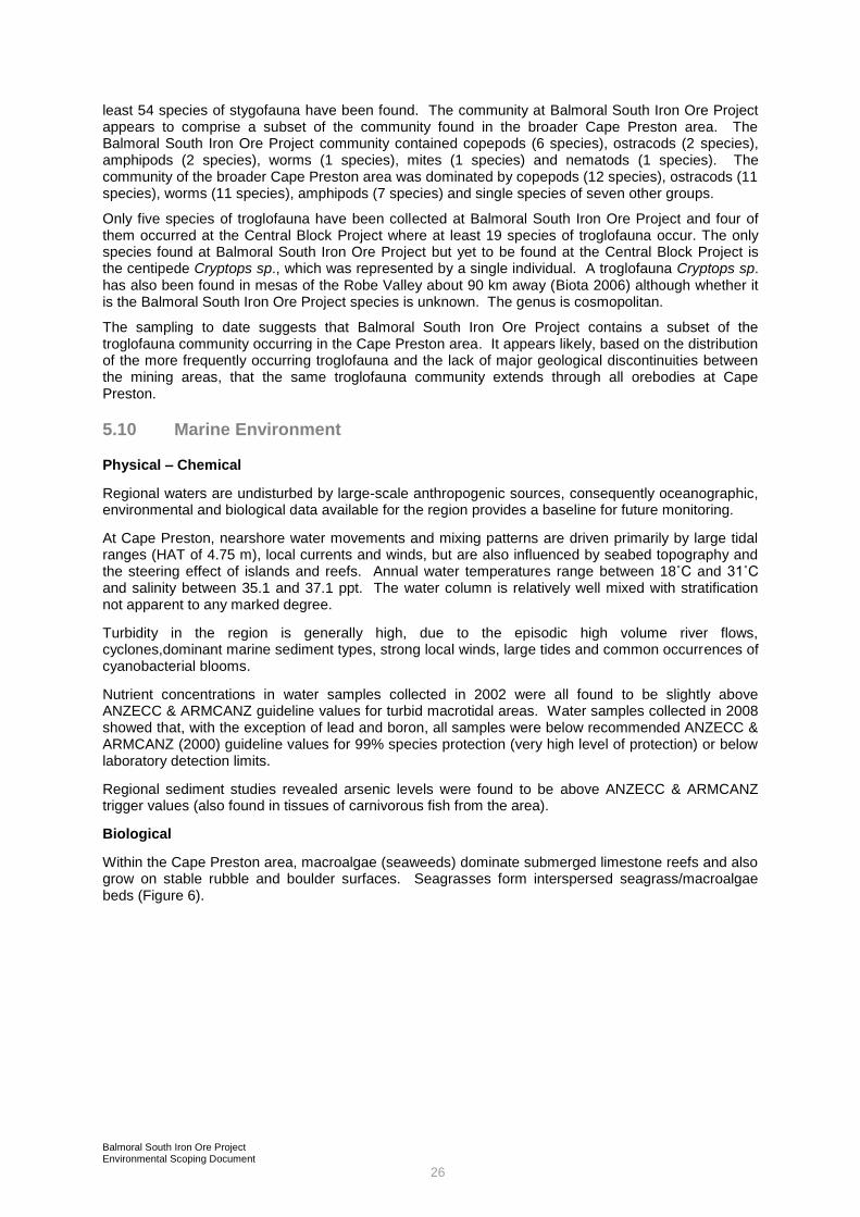
5.7 Mangroves
A well-developed mangrove system is associated with the
major tidal creek and connective tidal flats that join Cape
Preston with the mainland (Mangrove Creek). Other areas of
mangrove occur in the wider locality, including a generally
narrow zone of Avicennia marina which borders the western
shoreline and embayments between the creek and the mouth of
the Fortescue River.
The local occurrence of mangrove species and assemblages within the creek system exhibits similar patterns to those observed elsewhere in the region in relation to species distribution, local geomorphology and substrate. The most abundant and widespread species are Avicennia marina (dominant or co-dominant in most assemblages in the study area) and Rhizophora stylosa (which formed dense monospecific assemblages). The occurrence of Aegialitis annulata and Aegiceras corniculatum was strongly related to newly formed islands, accretionary creek banks or other zones of recent deposition. In the most seaward sections of the creek system, the substrates were sandy and rocky and the mangroves occurred here as a relatively narrow fringe. Further into the creek system, mangal development becomes more structurally complex and species richness increased particularly on the connective tidal land that bridges Cape Preston and the mainland.
Landward of the mangrove zone, expansive areas of high tidal mudflats extend to the margin of the tidal flats with the hinterland terrestrial vegetation. While the majority of the high tidal flats are devoid of vegetation, areas of cyanobacterial (algal) mats occur on the mudflat surface.
5.8 Terrestrial Fauna
Three detailed fauna surveys have been conducted over the project impact area. An initial survey was
undertaken in April 2000 in preparation of the Central Block Project PER (Halpern Glick Maunsell
2001) with additional surveys undertaken in 2006 by Maunsell Australia.
The fauna of the project area is dominated by avifauna (birds) and reptiles. Several species of
mammal are also common, predominantly consisting of small species such as native mice.
Eight species of conservation significance are reported by database searches to occur in the area, including the Northern Quoll, Night Parrot, Pilbara Olive Python and the migratory Peregrine Falcon. None of these species were recorded within the project area during any of the surveys.
Two species listed as migratory under the Environment Protection and Biodiversity Conservation Act
1999 were observed:
Merops ornatus (Bee-eater) - recorded regularly throughout the survey area; and
Haliaeetus leucogaster (White - bellied sea eagle) – one sighting recorded.
In general the fauna habitats within the project area are all well represented in the region and none are
regarded as regionally significant or unique. Of the habitats sampled, creek lines and cracking clays
dominated by Triodia spp yielded the highest number of species.
No mammal species of conservation significance were recorded during the field surveys. A targeted
search of low stony rises failed to identify any signs of the priority species or Pseudomys chapmani
(Western Pebble Mound Mouse) and targeted trapping of cracking clays failed to record Leggadina
lakedownensis (Lakeland Downs Mouse).
5.9 Subterranean Fauna
Sampling to date has identified 13 stygofauna species from Balmoral South Iron Ore Project, all of which have been recorded elsewhere in the Cape Preston area beyond the zone of impact where at
Mangrove Creek
Balmoral South Iron Ore Project Environmental Scoping Document
26
least 54 species of stygofauna have been found. The community at Balmoral South Iron Ore Project appears to comprise a subset of the community found in the broader Cape Preston area. The Balmoral South Iron Ore Project community contained copepods (6 species), ostracods (2 species), amphipods (2 species), worms (1 species), mites (1 species) and nematods (1 species). The community of the broader Cape Preston area was dominated by copepods (12 species), ostracods (11 species), worms (11 species), amphipods (7 species) and single species of seven other groups.
Only five species of troglofauna have been collected at Balmoral South Iron Ore Project and four of them occurred at the Central Block Project where at least 19 species of troglofauna occur. The only species found at Balmoral South Iron Ore Project but yet to be found at the Central Block Project is the centipede Cryptops sp., which was represented by a single individual. A troglofauna Cryptops sp. has also been found in mesas of the Robe Valley about 90 km away (Biota 2006) although whether it is the Balmoral South Iron Ore Project species is unknown. The genus is cosmopolitan.
The sampling to date suggests that Balmoral South Iron Ore Project contains a subset of the troglofauna community occurring in the Cape Preston area. It appears likely, based on the distribution of the more frequently occurring troglofauna and the lack of major geological discontinuities between the mining areas, that the same troglofauna community extends through all orebodies at Cape Preston.
5.10 Marine Environment
Physical – Chemical
Regional waters are undisturbed by large-scale anthropogenic sources, consequently oceanographic, environmental and biological data available for the region provides a baseline for future monitoring.
At Cape Preston, nearshore water movements and mixing patterns are driven primarily by large tidal ranges (HAT of 4.75 m), local currents and winds, but are also influenced by seabed topography and the steering effect of islands and reefs. Annual water temperatures range between 18˚C and 31˚C and salinity between 35.1 and 37.1 ppt. The water column is relatively well mixed with stratification not apparent to any marked degree.
Turbidity in the region is generally high, due to the episodic high volume river flows, cyclones,dominant marine sediment types, strong local winds, large tides and common occurrences of cyanobacterial blooms.
Nutrient concentrations in water samples collected in 2002 were all found to be slightly above ANZECC & ARMCANZ guideline values for turbid macrotidal areas. Water samples collected in 2008 showed that, with the exception of lead and boron, all samples were below recommended ANZECC & ARMCANZ (2000) guideline values for 99% species protection (very high level of protection) or below laboratory detection limits.
Regional sediment studies revealed arsenic levels were found to be above ANZECC & ARMCANZ trigger values (also found in tissues of carnivorous fish from the area).
Biological
Within the Cape Preston area, macroalgae (seaweeds) dominate submerged limestone reefs and also grow on stable rubble and boulder surfaces. Seagrasses form interspersed seagrass/macroalgae beds (Figure 6).

Balmoral South Iron Ore Project Environmental Scoping Document
27
Figure 6 Cape Preston benthic habitats
Fauna of the shallow water limestone reefs and platforms include hard and soft corals, sponges, ascidians, fan worms, molluscs (octopus, gastropods [snails], and bivalves), crustaceans (crabs, rock lobsters), urchins and sea stars. Dense areas of high coral cover are sparsely distributed in the region, whilst areas of low coral cover tend to occur as a thin border along steep slopes that descend from shallow algae dominated pavements around islands to a deep sandy seafloor. The nearest major reefs to Cape Preston which support high live coral cover are over 3 km away.
Available survey information obtained during three separate seasons indicates that the beaches of Cape Preston are utilised for a very limited amount of turtle breeding activity. The results suggest the northern end of the western beach is a nesting area for hawksbill turtles (Eretmochelys imbricate), the eastern beaches are used by the green turtle (Chelonia mydas) and south western beaches by flatback turtles (Natator depressus).
Balmoral South Iron Ore Project Environmental Scoping Document
28
In the Dampier Archipelago / Cape Preston region, small numbers of dugong (Dugong dugon) have been sighted in the shallow, warm waters in bays and between islands, including at East Lewis Island, Cape Preston, Regnard Bay, Nickol Bay and west of Keast Island. Current knowledge on the size of the population, distribution, migratory habits and regional and local importance of the Dampier Archipelago / Cape Preston area for dugongs is limited.
Migratory shorebirds utilise Pilbara coastal habitats such as beaches, tidal flats and other intertidal wetlands during the non-breeding season Migratory waders are protected under the Environment Protection and Biodiversity Conservation Act 1999 in addition to several international agreements. Fauna surveys undertaken in the Cape Preston areas in April 2000 and October 2002 recorded 16 species listed under the CAMBA, JAMBA and ROKAMBA international agreements, of which two species, the Ruddy Turnstone and the Sanderling, were recorded in internationally significant numbers on the coastal habitat (inter-tidal mudflats, sandy beaches and dunes) stretching from the southern side of Mangrove Creek to the tip of Cape Preston.
5.11 Local Land Uses
In 2002, Cape Preston was recognised by the State of Western Australia as a major future industrial area through the signing of a State Agreement with Mineralogy. In 2008 the potential of the Cape Preston area as a major iron ore mining and down stream processing precinct has been realised through the commencement of construction for the Central Block Project. Amongst other benefits, the State Agreement provides for secure land tenure for the development of the mining operation, processing facilities, supporting infrastructure and a port access at Cape Preston.
The mainland immediately adjacent to Cape Preston, Regnard Bay and the Fortescue River has been zoned for industrial use and is covered by mining and exploration leases held by Mineralogy. The project area is covered by the Balmoral Pastoral Lease.
IM has entered into a series of agreements with Mineralogy which provides for the rights and tenure to
all Mineralogy tenements necessary to carry out the project. These agreements have been agreed by
the Minister Resources Development and set out in the First Schedule of the Iron Ore Processing
(Mineralogy Pty Ltd) Agreement Act 2002 which was passed by the Parliament of Western Australia in
2002.
Although remote, Cape Preston and the Fortescue River mouth are used by Pilbara residents and
tourists for recreational pursuits, particularly fishing. The waters and shallow marine habitats of
Regnard Bay are fished recreationally by low numbers of visitors from Dampier and by itinerant “grey
nomads” that occupy the 40 mile beach camp site during winter months. Long term campers regularly
stay at the river mouth for periods of up to several months.
In addition to the mainland visitor points mentioned above, there are several islands located off the Pilbara coast which form the Great Sandy Island Nature Reserve. To the east, the Dampier to Cape Preston Marine Management Area will incorporate a number of other islands. The project lies adjacent to the Coastal Margin Cape Preston to Cape Keraudren National Estate (identification number 17917) to the east and the Coastal Margin Exmouth Gulf to Cape Preston natural area (identification number 17918), located to the south-west of the mouth of the Fortescue River. Both National Estates are Indicative Places that have yet to receive official status. There will be no direct project impacts on these areas.
In 2004 the Minister for Planning and Infrastructure approved an area of approximately 2555 ha to be excluded from Mardie Station as part of the "2015 Exclusion Process". The area was identified by the DEC as particularly valuable for its conservation value because of the Horseflats Land System (cracking clay soils) and related vegetation associations that are poorly represented within the conservation estate and, also, because of its contiguous nature with the sanctuary Zone within the Regnard Marine Management Area.
5.12 Heritage
Archaeological and ethnographic studies have previously been conducted in the Cape Preston region, including the Balmoral South Iron Ore Project area. The studies identified the Aboriginal Heritage values of the area and the presence of a number of sites of heritage significance.

Balmoral South Iron Ore Project Environmental Scoping Document
29
Local Aboriginal groups include the Wong-Goo_Tt_oo group, the Yaburara and Coastal Mardudhunera group, and the Kuruma Marthudunera group.
No sites of European heritage significance occur in the project area.

Balmoral South Iron Ore Project 30
Environmental Scoping Document
6.0 PRELIMINARY ENVIRONMENTAL IMPACT ASSESSMENT
This section outlines the potential impacts based on IM‟s current understanding of the receiving
environment, identifies the key issues relating to project activities and identifies the key factors relating
to the management of impacts.
6.1 Clearing Activities
Development of the project will require clearing to accommodate the pit, mine infrastructure, and
WDF‟s stockpiles, processing plant, plant infrastructure, infrastructure corridors, port infrastructure and
accommodation village.
The project could have the following impacts:
habitat loss as a result of clearing;
spread of Declared weed species; and
disturbance of indigenous heritage sites
Four Priority Flora are known to occur within the project area.
No species listed as Declared Rare Flora (DRF) by the Department of Environment and
Conservation(DEC), under the Wildlife Conservation Act 1950, or as Threatened under the EPBC Act
1999 were recorded within the survey area during any of the field assessments, nor did any DRF
result from database interrogations for the area.
Surveys indicate that most vegetation communities that could be affected by clearing are not
regionally or locally significant, and are well represented throughout the region. The exceptions are
the Cracking Clay Grasslands, phreatophytic vegetation communities and mangrove communities,
which are recognised as regionally significant. Pastoral lease boundary rationalisation planned for
2015 will ensure that substantial areas of Cracking Clay Grasslands are preserved within the
conservation estate. Project design requirements will also endeavor to minimise any clearing of these
grasslands within project area.
Impacts on flora and vegetation communities will be managed through a process of avoidance,
minimising disturbance, monitoring impacts and rehabilitation. Only areas specifically required for
construction and operation will be cleared. Rigorous management controls will be implemented to
ensure that personal and vehicles do not access any area not designated for clearing.
The Balmoral South Iron Ore Project area supports populations of the Declared Plant species
Prosopis pallida (Mesquite) and Datura leichhardtii (Native Thornapple) as well as several other
species of weeds.
Eight Priority Fauna under the Wildlife Conservation Act, ten species listed as Threatened under the
EPBC Act and 25 species listed as migratory under the EPBC Act potentially occur in the project area.
In general, it has been determined that the fauna habitats within the project area are all well
represented in the region and none are regarded as regionally significant or unique. Of the habitats
sampled, creek lines and cracking clays dominated by Triodia spp yielded the highest number of
species. No mammal species of conservation significance were recorded during the field survey. A
targeted search of low stony rises failed to identify any signs of the priority species Pseudomys
chapmani (Western Pebble Mound Mouse) and targeted trapping of cracking clays failed to record
Leggadina lakedownensis (Lakeland Downs Mouse).
An outfall pipeline is proposed to carry concentrated brine and filter backflush water to a discharge
diffuser located approximately 800 m northeast of the proposed Cape Preston harbour, located in
approximately 10m of water at Lowest Astronomical Tide. Benthic habitat mapping conducted for the
project area has identified that the pipeline and diffuser is to be located in an area of low
environmental sensitivity, mainly consisting of algal dominated limestone pavement and deep
sand/silt. These habitats have a widespread distribution in the greater region of the project.

Balmoral South Iron Ore Project Environmental Scoping Document
31
Archaeological and ethnographic studies were conducted for the greater Balmoral project area for the
previously assessed Central Block Project. All activities undertaken for the Balmoral South project will
be pursuant to the requirements of the Aboriginal Heritage Act 1972. Section 18 clearances to disturb
known sites will be sought as required.
The management objectives of the Balmoral South Iron Ore Project relating to the clearing activitites
are to:
minimize the area to be cleared to accommodate the works;and
protect adjacent vegetation from access by personnel or vehicles
6.2 Surface Water Management
The project will require construction of:
a WDF1 in the western extent of Leases M08/126 and 127, which will encroach on the Fortescue River floodplain;
a WDF2 in Lease G08/63, which will not encroach within the 100 year ARI floodplain of Du Boulay Creek floodplain;
the process plant and power station adjacent to Du Boulay Creek;
bunds within the 100 year ARI floodplain of Du Boulay Creek to protect stockpile areas, conveyors, ROM pad and primary crushing area;
an open-cut mine that, at the completion of mining, will partially fill with water; and
construction of service corridors across creeks including Mangrove Creek
The project could have the following potential impacts:
increase flood levels in the Fortescue River;
increase flood level and a change in the hydraulics of Du Boulay Creek;
long term salinity build-up in the pit lake;
an increase in erosion and sedimentation; and
changes to the hydrodynamics of Mangrove Creek resulting in the indirect loss of mangroves
The Balmoral South Iron Ore Project WDFs will occupy the western extent of Leases M08/126 and
127. They will be located in the Fortescue River floodplain west of the pit with the north end of the
WDF near Du Boulay Creek. A number of creeks and intertwining tributaries flow through the
proposed dump area.
Hydraulic modelling for the Central Block Project waste dump predicted that the maximum local 100
year ARI flood level would increase by about 0.4 m adjacent to the dump, with no impact predicted 6
km upstream of the dump. The construction of the Balmoral South Iron Ore Project WDF1 will
increase flood levels by around 0.37 m adjacent to the dump (0.3 m above those predicted for the
Central Block Project dump only) with no impact predicted 3km upstream of the dump (an increase of
1.5 km in the upstream extent of flooding over levels predicted for the Central Block Project dump
only).
The Fortescue River bridge on the north-west coastal highway is around 15 km upstream of the
project area. Increased flood levels in proximity to the project area will not impact on this structure.
The process plant and power station site is set along side Du Boulay Creek. The proposed stockpile
area, conveyor system, Run Of Mine stockpile pad and primary crushing area encroaches into the 100
year ARI floodplain but will be protected by bunding.
The bunds will restrict flow through the Du Boulay Creek in large flood events and cause water levels
to rise. The 100 year ARI flood levels were predicted to increase by about 1.6 m after construction of
the bunds around the plant site. Water velocities in this area should decrease due to the increased
flow depths.

Balmoral South Iron Ore Project Environmental Scoping Document
32
There will be some long term salinity build-up within the pit lake as a result of evaporative
concentration. However, as the pit will remain a groundwater sink, this saline water will largely remain
confined to the immediate pit area.
WDFs and stockpiles have the potential to discharge sediment laden water to the environment, and
surface runoff in general will typically be sediment laden. Excavation activities undertaken in
mangrove areas also have the potential to disturb acid sulfate soils resulting in the generation of acid
and the mobilisation of heavy metals.
The construction of port infrastructure across tidal creeks and within the intertidal areas generally has
the potential to modify tidal flows. Due to the lack of regular freshwater input into Pilbara zone
mangroves from hinterland areas, tidal inundation is the dominant recharge mechanism responsible
for maintaining the suitable groundwater / soil water conditions required for mangrove growth and
survival. Modifications to tidal wetting and drying regimes through a reduction in tidal flushing or
impoundment of water at higher levels can potentially impact mangroves.
The management objectives of the Balmoral South Iron Ore Project relating to surface water
management are to:
maintain the quantity and quality of water so that existing and potential environmental values, including ecosystem function, are protected;
ensure that structures remaining in flood prone areas at the cessation of the project are stable in the long term; and
minimise changes to the hydrodynamics of Mangrove Creek to avoid indirect impacts on mangrove communities
6.3 Dewatering Activities
Drawdown in groundwater levels due to dewatering activities will have the following impacts:
groundwater users: bores and wells which tap the basement rock aquifers will experience interference drawdowns and some shallow wells close to the pit may dry up;
phreatophytic vegetation: there is the potential for the loss of vegetation within the cone of depression of groundwater level drawdown, however seasoned recharge of the alluviums will provide some mitigation; and
stygofauna: potential loss of species and communities due to drawdown
The pit will be excavated to around 300 m deep. Dewatering and depressurisation will be a critical
component of mining. Average predicted inflows over the life of the mine are around 1,100 kL/day
(12.5 L/s) with peak dewatering requirements in the order of 1,700 kL/d (19 L/s).
Dewatering of Balmoral South Iron Ore Project will induce a drawdown in groundwater levels around
the pit. The lateral and vertical extent of the “cone of depression” in groundwater levels will be
dependent on the nature of local and regional aquifers, the depth of the pit and the “interference”
effects of dewatering at the nearby Central Block Project.
Modelling indicates that the cumulative impacts of both the Central Block and Balmoral South Iron Ore
Projects dewatering operations will result in one large elongated cone of depression. Groundwater
drawdown in close proximity to the mine will be at, or close to, the deepest section of the pit (around
300 mbgl). Predicted drawdown will extend 14 km northwards, 5 km southwards, 2 km to the west
and 7 km to the east. Predicted drawdown within the adjacent Fortescue River alluvial aquifers is
minimal.
Under cumulative abstraction conditions up to eight pastoral wells may be impacted by dewatering.
IM will provide alternative water supplies to any groundwater users adversely affected by their
operations.
Indirect impacts will occur to vegetation within the project area as a result of groundwater drawdown
through mine dewatering. Groundwater drawdown is expected to cause extended drying of water
pools, thereby impacting on riverine environments and Groundwater Dependent Ecosystems (GDEs)
such as phreatophytic vegetation. Shallow-rooted species are not likely to be directly affected by

Balmoral South Iron Ore Project Environmental Scoping Document
33
dewatering and consequently some vegetation cover may be retained. However, as a result of the
permanent loss of phreatophytic vegetation, understory species may also be lost depending on the
extent of drawdown, drawdown level and drawdown rate. Vegetation risk assessments have been
based on the predicted drawdown in basement rock aquifers and take no account of seasonal creek
flows and perched water tables within the main creeks which support much of the vegetation at risk.
It is unlikely that dewatering at Balmoral South Iron Ore Project will affect conservation of stygofauna
species. With 13 species recorded, Balmoral South Iron Ore Project is not rich in stygofauna and all
species present are known to be more widely distributed.
The trogofauna collected at Balmoral South Iron Ore Project appears to represent a subset of the
Central Block Project trogofauna community. Although there is no evidence from sampling, it may
reasonably be inferred that the troglofauna species present at Balmoral South Iron Ore Project will
also occur in the surrounding Brockman Iron Formation, which will not be mined.
The management objectives of the Balmoral South Iron Ore Project relating to groundwater are to:
Manage the quantity and quality of water so that existing and potential environmental values, including ecosystem maintenance, are protected; and
ensure that discharges do not adversely affect water quality or the health, welfare and amenity of people and land uses by meeting statutory requirements and acceptable standards
6.4 Atmospheric Emissions
Particulates, oxides of nitrogen, carbon monoxide and sulphur dioxide will be emitted from:
the power station consisting of closed-cycle gas turbines; and
the main stack of the pellet plant
Under normal operations, air emissions will only occur through the main stack after passing through a
dust control device to limit the particulate concentrations to 50 mg/m3.
Highest 24-hour NOX and 1-hour NO2 concentrations occur within the first 500 to 1000 m of the
proposed pellet plant. The contribution from the power station to the predicted ground level
concentrations is low. Comparison to the NOX vegetation criteria indicates that this would be
exceeded within 800 m of the pellet plant but that the concentrations would decrease rapidly with
distance. Concentrations of particulates, carbon monoxide and sulphur dioxide are all below criteria.
Regional ozone concentrations are well below criteria at sensitive receptors.
The project will produce the following greenhouse gases:
carbon dioxide;
methane;
sulphur dioxide; and
oxides of nitrogen
The sources of these emissions include:
pellet plant;
gas turbines at the power station;
combustion of diesel fuel in mobile plant and equipment used for construction and mining;
decomposition of cleared vegetation;
explosives used in blasting; and
decomposition of domestic wastewater
Dust will be generated from a number of activities including:
vegetation clearing, topsoil clearing and replacement;
vehicle movements on the access roads and site roads during construction and operations;
mining activities (blasting, earthmoving and dumping);

Balmoral South Iron Ore Project Environmental Scoping Document
34
materials handling and processing activities including crushing, screening, stacking and reclaiming of ore; and
dust pick-up (wind erosion) from exposed areas including the pit, areas cleared for the process plant and offices, access roads, stockpiles, WDFs and the accommodation village
Given the remoteness of the nearest sensitive premise, no construction or operational dust impacts
are expected.
The management objectives of the Balmoral South Iron Ore Project relating to atmospheric emissions
are to:
minimise atmospheric emissions to as low as reasonably practicable;
use all reasonable and practicable measures to minimise airborne dust; and
minimise emissions of greenhouse gasses to levels as low as practicable
The assessment will ensure that impacts from the project are understood and assessed in the context
of impacts arising from other projects in the area.
6.5 Waste Management
The project will generate waste that can be broadly categorised into the eight types:
dewatered tailings produced during ore concentration.
industrial waste including oil filters, hydraulic hose, workshop waste, waste oil, tyres, etc;
putrescibles (general domestic waste);
inert waste including asphalt, concrete, etc;
wastewater including sewage, grey water and washdown water;
hazardous waste including pyritic black shales (acid mine drainage) and fibrous materials;
recyclable waste including aluminium products, scrap metals, wire, etc; and
brine discharge from the desalination plant
The waste will be managed in an appropriate manner. The potential impacts include the contamination of land, change in water quality of surface water and groundwater, and / or contamination of ecological habitats.
Both on-site and off-site facilities will be used to ensure appropriate disposal of all waste streams.
Inert waste and putrescibles will be collected and disposed in a landfill sited and managed in
compliance with the Draft Code of Practice for Rural Landfills. All industrial waste will be removed
from the project site to a registered landfill or recycling facility, using appropriate certified contractors.
If accidental hydrocarbon spills do occur then an appropriately located on-site bioremediation land
farm will be established. Sewage waste will be treated through a package treatment system and
appropriately disposed to meet health regulations.
Water recovery from the tailings may be conducted via a tailings thickening process. Minimization of
water in the WDF will also reduce the potential for surface water contamination.
The presence of any pyritic black shales, which can give rise to acid mine drainage, and fibrous
forming minerals will be identified during drilling. Management of these materials, if present, will be
determined through consultation with relevant authorities.
The seawater outfall will only be used for brine discharge from the desalination plant. All onshore wastewater, including power station cooling water blowdown and effluent from wastewater treatment plants will either be recycled or used onshore for dust suppression or irrigation.
The desalination plant‟s brine will contain concentrated dissolved solids (TDS) and concentrated
suspended solids (TSS) as well as chemical additives used in the desalination process. The
maximum TDS discharged will be 78.8 g/L at a temperature no greater than 2° C above the
temperature of the intake seawater. TSS concentration will vary between 10 and 34 mg/L.

Balmoral South Iron Ore Project Environmental Scoping Document
35
The discharge of brine has the potential to:
change local marine water and TDS and TSS concentrates;
adversely affect individual marine biota within the vicinity of the outfall; and
reduce the abundance of sensitive benthic primary producer habit, including coral communities
The most appropriate way to avoid the above impacts is to select a disposal site that does not
currently support a high abundance of corals, seagrass or algae, ensure that sufficient depth of water
is available at low tide for initial dilution to occur rapidly, and ensure that the waters above the outfall
are well flushed and mixed.
The PER will model the brine discharge and demonstrate its acceptability in relation to the size of the
mixing zone, the presence of any residual chemicals and the impact of the discharge on the marine
ecosystem. The PER will demonstrate that a specific ecotoxicology study is not required.
The management objectives of the Balmoral South Iron Ore Project relating to waste management are
to:
ensure that waste rock and tailings are emplaced in WDF that isolated long time
integrate a waste hierarchy (i.e. avoid, reuse, reduce, recycle, treat, dispose) for waste minimisation and establish a „closed loop‟ within as many waste streams as possible;
ensure no release of hydrocarbons to the environment, either as a result of storage or handling incidents;
ensure no discharge of waste to the sea;
limit the area required for brine mixing surrounding the diffuser
6.6 Noise Emissions
The project will generate noise from a variety of sources including blasting, use of mining equipment,
mineral processing, materials handling, conveyor use and the power station. The project area is
within the boundaries of the Mardie pastoral lease and is remote from any substantial human
development. The closest noise sensitive receivers are the two miner‟s camps (7 km south and 9 km
north east of the pit) and the public camping ground at the mouth of the Fortescue River (11 km to the
north west).
The management objective of the Balmoral South Iron Ore Project relating to noise emissions is to
protect the amenity of nearby residents from noise impacts resulting from the project area. Noise
assessment will need to ensure that impacts from the project are understood and assessed in the
context of impacts arising from other projects in the area.
Modelling results show compliance with the relevant Environmental Protection (Noise) Regulations
1997 criteria at all potentially impacted noise-sensitive receivers surrounding the site.
6.7 Adjacent Land Users
Pastoral grazing is the only significant activity in the project area. The potential issues that may
impact upon this land use include:
disruption to cattle mustering operations;
damage or removal of fencing;
interruption to the water supply for cattle;and
access to sites within the Pastoral Lease and possible interference with pastoral infrastructure
Water supply to eight wells is likely to be affected by groundwater drawdown from dewatering.
The management objective in relation to adjacent land users is to minimise any direct or indirect
impact from the operations.

Balmoral South Iron Ore Project Environmental Scoping Document
36
Cattle mustering occurs periodically throughout the year. Management strategies will be developed to
accommodate these events and to schedule activities that may impact on the mustering operations.
Any fencing requiring removal will be replaced and relocated as agreed with the pastoralist.
Monitoring will be undertaken of all wells in the area and alternative water supply provided should the
project impact on water availability.
6.8 Recreational Activities
The construction and operations workforces will operate on a fly-in / fly-out basis and consequently
there will be limited time available for the workforce to significantly increase recreational pressures in
the area. Nonetheless, the influx of a sizable construction and operations workforce has the potential
to increase recreation activity in the area placing added pressures on
areas protected in reserves;
nesting birds and turtles using sandy beaches in the area;
sensitive areas such as marine habitats and mangrove communities;
fishing (open water, river and beach);
boating;and
pastoral and other commercial activities
The management objectives of the Balmoral South Iron Ore Project relating to recreational activities
are to:
manage the impact of mine employees and contractors on the “visitor locations” within the vicinity of the project site to minimise the degradation of these location;
ensure that access to popular “visitor sites” is maintained for the use of the general public; and
ensure that recreational activities do not significantly increase pressure on the natural resources of the area

Balmoral South Iron Ore Project Environmental Scoping Document
37
7.0 MATTERS OF NATIONAL ENVIRONMENTAL SIGNIFICANCE
Under the Environment Protection and Biodiversity Conservation Act 1999 (EPBC Act), an action
requires approval from the Commonwealth Minister for the Department of Environment, Water,
Heritage and the Arts if the action has, will have, or is likely to have a significant impact on a Matter of
National Environmental Significance (MNES). The MNES are:
World Heritage Properties;
National Heritage places;
Ramsar wetlands of international significance;
Nationally listed threatened species and ecological communities;
Listed migratory species;
Commonwealth marine areas; and
Nuclear actions.
In May 2008, IM referred the Balmoral South Iron Ore Project to the Department (EPBC Ref
2008/4236). On 2nd July 2008 the project was determined to be a “controlled action”, and will
therefore require approval under the EPBC Act. The controlling provisions were that the project was
likely to have a significant impact on listed threatened species and communities (Section 18 and 18A)
and listed migratory species (Section 20 and 20A).
The PER to be prepared under the Western Australian Environmental Protection Act 1986 will
determine which species are likely to be impacted by the project and apply the MNES Significance
Guidelines to determine the significance of the impact.
The environmental assessment of the Balmoral South Iron Ore Project will be conducted in
accordance with the “Agreement between the Commonwealth of Australia and WA under Section 45
of the EPBC Act Relating to the Environmental Impact Assessment (the bilateral Agreement) and in
conformance with the Cooperative Arrangements to the Bilateral”. The potential for the project to
impact on the MNES will be assessed in accordance with DEWHA‟s Administrative Guidelines (DEW,
2006), which state that:
“In order to decide whether an action is likely to have a significant impact it is important to
consider matter such as:
The sensitivity of the environmental which will be impacted;
The timing, duration and frequency of the action and its impacts;
All on-site and off-site impacts;
All direct and indirect impacts;
The total impact which can be attributed to the action over the entire geographic area
affected, and over time;
Existing levels of impact from other sources; and
The degree of confidence with which the impacts of the action are known and understood”.

Balmoral South Iron Ore Project Environmental Scoping Document
38
8.0 ENVIRONMENTAL FACTORS, INVESTIGATIONS CONDUCTED TO DATE, POTENTIAL MANAGEMENT AND PROPOSED STUDIES
Table 4 identifies the key environmental factors that are relevant to the Balmoral South Iron Ore
Project, the potential impact of the project on these factors, work required to support the PER and the
likely actions that will be taken to mitigate or manage impacts.

Balmoral South Iron Ore Project Environmental Scoping Document
39
Table 4 Environmental factors
Environmental
factor
Environmental
objective
Project component /
Potential impacts Work required Potential management
BIOPHYSICAL
Terrestrial
vegetation and
flora
Maintain the abundance,
diversity, geographic
distribution and productivity
of flora at species and
ecosystem levels through
the avoidance or
management of adverse
impacts and improvement in
knowledge.
Protect species listed under
the Environment Protection
and Biodiversity
Conservation Act 1999 and
Rare and Priority Flora
consistent with the
provisions of the Wildlife
Conservation Act 1950.
Vegetation clearing
Field survey of the project area to document and
map vegetation types and flora present. Survey to
be undertaken consistent with EPA Position
Statements No. 2 and No. 3, and Guidance
Statement No. 51.
Overlay project components onto habitat mapping
to quantify impacts.
Identification of any Threatened or Priority Flora,
unusual or poorly known taxa, or restricted
vegetation types (including Threatened Ecological
Communities [TECs]).
Evaluation of the local and regional conservation
significance of the species and vegetation types
present, including species at their geographical
limits.
Analysis of clearing areas to quantify loss of
vegetation and identify impacts on Threatened or
Priority Flora or TECs.
Minimise the extent of clearing required
for construction and operation activities.
Clearing control procedures to be
implemented during construction.
Progressive rehabilitation of disturbed
areas where possible.
Threatened flora
Priority flora has been
identified from the Cape
Preston region.
Detailed design will consider the
locations of Priority Flora and
disturbance will be avoided where
possible.
Cracking Clay Grasslands
Cracking clay grasslands are
recognised as regionally
significant vegetation
communities.
Detailed design will consider the
presence of Cracking Clay Grasslands
and disturbance will be avoided where
possible.
Pastoral lease boundary rationalisation
in 2015 will ensure that substantial
areas of these grasslands are
preserved within the conservation
estate.
Phreatophytic vegetation
(GDEs)
Phreatophytic vegetation will
be impacted by groundwater
drawdown.
Mapping of phreatophytic communities at risk from
dewatering, modelling of groundwater drawdown
and quantification of potential community loss.
There will be some unavoidable loss of
phreatophytic vegetation but it will be
minimised by reducing water level
drawdown rates where possible,
monitoring vegetation and vegetation
stress and implementing management
measures at identified trigger levels.

Balmoral South Iron Ore Project Environmental Scoping Document
40
Environmental
factor
Environmental
objective
Project component /
Potential impacts Work required Potential management
Weeds
The Declared species have
been identified from the project
area.
Potential to spread weeds to
uninfected areas.
Field survey to document the extent and
occurrence of introduced flora in the project area.
Development of weed management
and hygiene plan.
Ongoing weed control programme to be
implemented during operations.
Mangroves Maintain the abundance,
diversity, geographic
distribution and productivity
of mangroves and
mangrove associations
through the minimisation of
direct and indirect impacts.
Mangrove communities
There will be direct mangrove
habitat lose through clearing to
allow the infrastructure corridor
to be built across Mangrove
Creek.
Potential indirect impacts
through potential changes in
hydrodynamics.
Document the condition and local and regional
representation of mangrove species /
assemblages.
Evaluate the local and regional significance of
affected mangrove areas.
Quantify the extent of mangrove clearing and
identify aspects of the project with the potential to
restrict or alter tidal flushing.
Assess impacts against EPA Guidance Statement
No. 1 and No. 29.
Adoption of construction techniques to
minimise mangrove clearing and
changes to hydrodynamics.
Implementation of a Mangrove
Monitoring Program.
Terrestrial fauna Maintain the abundance,
diversity, geographic
distribution and productivity
of fauna at species and
ecosystem levels through
the avoidance or
management of adverse
impacts and improvement in
knowledge.
Protect species listed under
the Environment Protection
and Biodiversity
Conservation Act 1999 and
Schedule and Priority Fauna
consistent with the
provisions of the Wildlife
Conservation Act 1950.
Fauna habitat
Clearing vegetation.
Field survey of project area to document fauna
communities, threatened taxa and potential short-
range endemics. Survey to be undertaken
consistent with EPA Position Statement No. 3 and
Guidance Statement No. 56.
Evaluation of the local and regional significance of
the fauna and communities present.
Quantify reduction in extent of habitat attributable
to the project, with evaluation of impacts on fauna
occurring on the affected habitat types and on
patterns of fauna movement (corridors).
Detailed design will be undertaken to
minimise as much as practical the
extent of clearing for construction and
operational activities.
Impacts on fauna will be managed
through a process of minimising the
area to be disturbed, workforce
education, avoidance, monitoring
impacts, implementation of remedial
strategies where practical and
progressive rehabilitation of disturbed
areas where possible.
Threatened fauna
Priority fauna may occur within
the project area.
Some threatened and
migratory species under the
EPBC Act potentially occur.

Balmoral South Iron Ore Project Environmental Scoping Document
41
Environmental
factor
Environmental
objective
Project component /
Potential impacts Work required Potential management
Subterranean
fauna and other
Short Range
Endemics
To maintain the abundance, diversity, geographic distribution and productivity of subterranean fauna and other short range endemics at the species and ecosystem levels through the avoidance or management of adverse impacts and improvement in knowledge.
Subterranean fauna
Groundwater extraction has
the potential to affect
stygofauna.
Stygofauna and troglofauna
will be impacted through
habitat loss.
Review all information on subterranean fauna in the locality and its conservation value. Document the potential impacts of the Central Block and Balmoral South Iron Ore Projects on groundwater drawdown and the amount of orebody likely to remain after development of the projects over next 25 years. Assess the risk of the projects to the biodiversity values of subterranean fauna in the region. Undertake surveys on the areas of impact for the IM Project in accordance with EPA Guidance Statements 54 and 54a (draft). Undertake a risk assessment and if appropriate, surveys for short-range endemic fauna over the disturbance and wider impact footprint in order to assess impacts and recommend appropriate management/mitigation strategies. Investigations into whether claypans are found in the adjacent flats and floodplains that may be impacted by the proposal.
Minimise impacts to subterranean fauna and other short range endemic species. In the event that the subterranean fauna sampling indicates that species may be at risk as a result of the dewatering activities, scopes of work for the development of contingency measures (which may include further investigation outside the footprint or the development of stringent monitoring and management measures) will be included in the PER.
Marine biota Maintain the ecological
function, abundance,
species diversity and
geographical distribution of
marine biota and habitat.
Construction of the seawater
intake, brine outfall and
diffuser could impact on
Benthic Primary Producers
(BPP) and Benthic Primary
Producer Habitat (BPPH).
Habitat disturbance to turtle
nesting areas and shorebird
roosting and feeding areas.
Seawater intake is potentially
hazardous to marine fauna.
Field surveys to document the presence of BPPH
and the presence of any species of conservation
significance.
Evaluation of the local and regional conservation
significance of species present.
Assessment of impacts consistent with EPA
Guidance Statement No. 29.
Design of the seawater intake to
minimise the potential ingress of marine
fauna.
Selection of the pipeline corridors to
avoid, where possible, BPPH.
Filling of the pipeline trench‟s with rock
to construct artificial reef.

Balmoral South Iron Ore Project Environmental Scoping Document
42
Environmental
factor
Environmental
objective
Project component /
Potential impacts Work required Potential management
Surface water Maintain the quantity of
water so that existing and
potential environmental
values, including ecosystem
function, are protected.
Maintain the integrity,
ecological functions and
environmental values of
wetlands.
Flood levels
WDF1 will encroach into the
floodplain of the Fortescue
River with the potential to
impact on flood level and
extent.
Mine site, infrastructure and
WDFs will impact surface
waters and there is the
potential for impacts should
their flood protection works fail.
Undertake hydraulic modelling of surface water
flows in the Fortescue River and Du Boulay Creek
to quantify potential changes as a result of the
project.
Demonstrate that infrastructure and facilities that
encroach on floodplains will withstand flood events
with minimal likelihood of catastrophic failure.
Detailed design to minimise impacts
including:
bunding to redirect surface water around mine structures;
riprap / armouring to slow and redistribute runoff;
culverts to maintain major flow paths intercepted by infrastructure;
location of mine site infrastructure to minimise encroachment into the 100yr ARI floodplain;
drainage works around the waste
dump;
bunding to contain contaminated
runoff. Sedimentation
Modification of sediment
transport, erosion and
deposition patterns.
Prevent erosion of WDFs
Groundwater Maintain the quantity and
quality of water so that
existing and potential
environmental values,
including ecosystem
function, are protected.
Dewatering
Dewatering will cause a cone
of depression in the local water
table. Potential to impact on
phreatophytic vegetation,
stygofauna and groundwater
users.
Modelling of the cumulative cone of depression
from the Central and Balmoral South Iron Ore
Projects to determine impact on groundwater
levels.
Monitoring of water level drawdown.
Establish trigger levels for the provision
of alternative water supply to
phreatophytic vegetation and
groundwater users.
Matters of
National
Environmental
Significance
Ensure that the project does
not significantly impact of
Matters of National
Significance or Other
Matters Protected by the
EPBC Act.
Listed threaten species and
communities (sections 18 and
18A)
Listed migratory species
(section 20 and 20A)
Determine which species are likely to be impacted
by the project and apply the MNES Significance
Guidelines to determine the significance of the
impact.
If required, develop and implement
management measures to reduce or
eliminate the potential impact.

Balmoral South Iron Ore Project Environmental Scoping Document
43
Environmental
factor
Environmental
objective
Project component /
Potential impacts Work required Potential management
POLLUTION MANAGEMENT
Air Quality Ensure that emissions do
not adversely affect
environment values or the
health, welfare and amenity
of people and land uses.
Dust emissions
Earthworks, mining, ore
processing and ore handling
will produce dust.
Identify potential sources of dust and quantify likely
impacts on the receiving environment.
Impact assessment and management will recognise the requirements of the Draft DEC Dust Guidance Statement.
Project design will ensure that dust is
captured at source wherever practical.
Dust will be managed using standard
dust suppression techniques such as
water sprays, chemical suppressants
and revegetation.
Dust monitoring will comply with the
current ambient air quality NEPM and
monitor PM10. Monitoring of PM2.5 will
also be undertaken.
Process emissions
The pellet plant and power
station will emit particulates,
carbon monoxide and oxides
of nitrogen and sulphur dioxide
which have the potential to
adversely impact on human
and animal health, and
vegetation.
Modelling of emissions to determine compliance
with appropriate standards and guidelines.
The assessment will consider cumulative
emissions from the approved Central Block
Project.
Undertake modelling in accordance with the DoE‟s
Air Quality Modelling Guidance Notes.
Project design will ensure that levels of
atmospheric pollutants are minimised at
source wherever practical.
Demonstrate that best practicable
technology has been adopted for the
design and construction of the power
station, particularly with regards to NOX
emissions, in line with the EPA
Guidance Statement No.15.
Photochemical smog
The power station and pellet
plants will emit oxides of
nitrogen which could lead to an
increase in photochemical
smog in the region.
Undertake a photochemical smog study which
accounts for other emissions in the region.
Undertake modelling in accordance with the DoE‟s
Air Quality Modelling Guidance Notes.
Greenhouse
gases
Minimise emissions to levels
as low as practicable on an
on-going basis and consider
offsets to further reduce
cumulative emissions.
The project will generate
greenhouse with the highest
emissions will occur from the
power station.
Quantification of greenhouse gas emissions and
demonstration that emissions are as low as
reasonably practical.
Development of a Greenhouse Gas
Management Strategy and
implementation of the plan over the life
of the project.
Minimising emissions to levels as low
as reasonably practicable on an on-

Balmoral South Iron Ore Project Environmental Scoping Document
44
Environmental
factor
Environmental
objective
Project component /
Potential impacts Work required Potential management
going basis:
improving fuel consumption efficiency per tonne of ore hauled;
focussing on the quality of fuel / lubricants used with an objective to reduce hydrocarbon waste and increase productivity per truck;
assessing alternative waste and ore disposal technologies, such as in-pit crushing and conveyor to reduce fuel burn.
Surface and
groundwater
quality
Maintain the quality of
surface water and
groundwater to ensure that
existing and potential uses,
including ecosystem
maintenance are protected
Surface water
Potential for downstream water
quality to deteriorate from the
discharge of chemicals and
hydrocarbons from the
workshop and plant areas,
seepage from the WDFs and
discharge from the sewage
treatment plant.
Describe the type and quantities of:
domestic and industrial wastes;
process wastes; and
construction wastes.
Characterisation of waste materials and the
potential for seepage to contaminate groundwater.
Assess the environmental threats posed by the
wastes identified.
Determine appropriate disposal procedures and
specify relevant limits and standards.
Project design to minimise waste and
incorporate environmentally appropriate
technologies for waste management.
Development of a waste management
plan with procedures to ensure
appropriate handling, treatment and
disposal of wastes and identification of
opportunities to avoid, reduce,
ameliorate and manage development
wastes.
Construction of diversion works around
infrastructure areas to separate natural
runoff waters from internal site runoff.
Groundwater
Potential contamination of the
Fortescue River Alluvial
aquifer.
Design of the WDFs to minimise
seepage.
Monitoring to detect any seepage and
contingency measures to correct
unacceptable contaminate loss.
Pit void
Long term build up of salinity in
the pit lake from evaporative
concentration which could
locally impact groundwater
Assessment of changes to water quality in the pit
over time and prediction of the likely environmental
impact of these changes.
Minimisation of the final void and
development of a Preliminary
Decommissioning and Closure Plan
which includes addressing the long
term management of the pit void.

Balmoral South Iron Ore Project Environmental Scoping Document
45
Environmental
factor
Environmental
objective
Project component /
Potential impacts Work required Potential management
quality.
Marine water
quality
Maintain water and
sediment quality consistent
with the Australian and New
Zealand Guidelines for
Fresh and Marine Water
Quality.
Protect environmental
values for recreation,
aesthetics, aquatic life and
maintenance of ecosystems
in specified areas.
There is the potential to:
reduce local marine water and sediment quality;
adversely affect individual marine biota within the vicinity of the outfall; and
reduce the abundance of sensitive benthic primary producer habitat, including coral communities.
Field survey to describe the existing environment
including mapping and benthic habitat
characterisation and classification.
Modelling of the Central Block and Balmoral South
Iron Ore Projects outfalls to determine the
cumulative impact of brine discharge on the marine
environment. Modelling will predict the frequency,
duration and intensity of discharge events to the
marine environment and associated zones of
impact. Hydrodynamic analysis in the context of
understanding the marine environment, flushing
capacity and dilution capacity for the desalinisation
discharge.
Assess impacts against EPA Guidance Statement
No. 29.
Impact predictions will be prescribed and spatially
defined in the context of the environmental quality
management framework presented in the Pilbara
Coastal Water Quality Consultation Outcomes:
Environmental Values and Environmental Quality
Objectives (DoE 2006).
Investigations will spatially define and justify the
environmental quality objectives around the outfall
and the environmental values that will be
protected.
Justify the location of the discharge point and
confirm that the discharge will not impact water
quality and biodiversity values of the Regnard
Marine Management Area.
Develop a Quality Management
Strategy for assigning zones of impact,
predicting loss of benthic habitats and
applying appropriate ecological water
quality standards and criteria for
monitoring and management.
Monitor relevant parameters in the
desalination plant outfall to confirm
modelling predictions and ensure that
salinity and toxicants do not exceed
stipulated limits.
Monitor ecosystem health indicators in
the receiving environment.
Noise Protect the amenity of
nearby residents from noise
impacts resulting from
Mining, ore processing and ore
handling will produce noise
emissions with the potential to
Noise and vibration modelling using SoundPLAN to
demonstrate compliance with the Environmental
Protection (Noise) Regulations 1997.
Design of the project to minimise noise
and vibration emissions and review
operational procedures if noise

Balmoral South Iron Ore Project Environmental Scoping Document
46
Environmental
factor
Environmental
objective
Project component /
Potential impacts Work required Potential management
activities associated with the
proposal.
impact the public and the
workforce. Blasting will be
employed during mining
Assessments and management of impacts to
marine and terrestrial fauna associated with noise
emissions during construction and operation.
emissions exceed agreed limits.
Solid and Liquid
Wastes
Minimise any solid and
liquid wastes produced as a
result of the project.
Integrate a waste hierarchy
(i.e. avoid, reuse, reduce,
recycle, treat, dispose) for
waste minimisation and
establish a „closed loop‟
within as many waste
streams as possible.
Ensure no release of
hydrocarbons to the
environment, either as a
result of storage or handling
incidents.
Ensure liquid and solid
wastes are treated onsite or
disposed of off-site at an
appropriate landfill facility.
The project will generate a
variety of waste materials
including scrap metal, tyres,
wood, paper, hydrocarbons,
domestic solid and liquid
wastes and processing
wastes.
If these wastes are not
managed in an appropriate
manner, a range of potential
impacts are possible. These
include the contamination of
land, change in water quality of
surface water and
groundwater, and/or
contamination of ecological
habitats.
Describe the types of wastes including:
domestic, industrial and hazardous wastes (e.g. waste water and workshop wastes);
mining wastes (e.g. waste rock); and
process wastes (e.g. tailings and waste water).
Identify management options for the various waste
streams.
The management measures for solid
and liquid wastes are:
storing hydrocarbons in approved bunded facilities;
bioremediating hydrocarbon contaminated soils onsite;
collect and remove waste oils;
recycling wastes such as batteries, and scrap metal;
disposing non-recyclable domestic and industrial waste to an onsite landfill;
treating sewage and grey water for reuse; and
SOCIAL SURROUNDS

Balmoral South Iron Ore Project Environmental Scoping Document
47
Environmental
factor
Environmental
objective
Project component /
Potential impacts Work required Potential management
Recreation Manage the impact of mine
employees and contractors
on the “visitor locations”
within the vicinity of the
project site.
Ensure that access to
popular “visitor sites” is
maintained for the use of the
general public.
Ensure that recreational
activities do not significantly
increase pressure on the
natural resources of the
area.
Potential to impact on the
camping ground at the mouth
of the Fortescue River. An
influx of construction and
operations personnel has the
potential to place additional
pressure on the environment.
Quantify impacts on existing recreational uses and
resources in the area.
All project personnel will undergo a site
specific environmental induction before
commencing work at the operation.
The induction will include information
regarding the responsibilities and
expected behaviour of all personnel
toward the environment, and will
provide necessary awareness of
recreational impacts and how those
impacts will be managed.
Aboriginal
Heritage
Avoid or minimise impacts
to Aboriginal cultural
heritage sites.
To ensure that the proposal
complies with the
requirements of the
Aboriginal Heritage Act
1972.
Potential impact on sites of
Aboriginal significance.
Finalise Heritage Agreements, management plans
or other agreements following further consultation
with the Claimant Groups and the Department of
Indigenous Affairs.
Conduct further surveys across the Balmoral South
Iron Ore project area in consultation with local
Aboriginal groups.
Implement procedures for the
identification and management of any
additional sites located during the
construction and operational phases of
the project. This may include the use of
monitors during ground disturbing
activities and the development of
specific procedures for the preservation
of heritage sites.
European
Heritage
Ensure that changes to the
biological and physical
environment resulting from
the project do not adversely
affect historical and cultural
associations with the area
and comply with relevant
heritage legislation
There are no European
heritage sites known to occur
within the project Area.
- No specific management is required.
Public health and
safety
Ensure that the risk to the
public is as low as
The potential health and safety
issues for the project are:
Demonstrate an understanding of the potential
impacts of the project on public health and safety
Exclusion of the general public from the
project area.

Balmoral South Iron Ore Project Environmental Scoping Document
48
Environmental
factor
Environmental
objective
Project component /
Potential impacts Work required Potential management
reasonably practicable and
complies with appropriate
standards♣.
Ensure that traffic activities
resulting from the project do
not adversely impact on the
social surroundings.
Ensure that the risk is
managed to comply with
DoIR requirements and EPA
criteria in respect of public
health and safety.
traffic on the Fortescue River access road;
public access to the project area;
spillage of hazardous materials on public roads;
process emissions from the pellet plant and power station;
dust from exposed areas and materials handling.
and document the measures proposed to minimise
or mitigate the impact.
Ongoing management of the Fortescue
River access road, dust management
through the use of water carts (or
similar), vehicle speed restrictions and
adoption of safety procedures and
installation of spill kits on transport
vehicles.
OTHER
Cumulative
impacts for IM
Assessment
Ensure that impacts from
the project are understood
and assessed in the context
of impacts arising from other
approved projects in the
area.
Development of the Balmoral
South Iron Ore project will
result in impacts that that will
need to be assessed in
relation to the approved
Central Block Project.
Quantify impacts associated with the Balmoral
South Iron Ore project and assess impacts in
relation to those predicted for the approved Central
Block Project. In particular the PER will address
individual and cumulative impacts associated with
the following factors:
terrestrial flora and vegetation;
mangroves;
terrestrial fauna;
subterranean fauna;
marine ecology;
surface water including risk of infrastructure failure;
groundwater;
process emissions;
marine water quality; and
noise
Management measures will be
determined on the issues identified and
would be addressed under each
specific factor.
Cumulative Provide the EPA with a high Provided for information Assessment of the cumulative impacts of the four -

Balmoral South Iron Ore Project Environmental Scoping Document
49
Environmental
factor
Environmental
objective
Project component /
Potential impacts Work required Potential management
Impacts
considering all
future Cape
Preston projects
level understanding of the
cumulative impacts arising
from the development of
four projects in the area.
purposes only and does not
form part of the IM
assessment.
projects proposed for the area at a high level,
using available information and conceptual project
descriptions. This Cumulative Impact Assessment
will be appended to the PER.
Decommissioning
and Closure
To ensure that rehabilitation
occurs in a planned
sequential manner
consistent with best
practice.
Mining will result in excavation
and the establishment of
WDFs.
Assessment of potential impacts on existing
landforms. Detail measures proposed to
rehabilitate the impacted area to an acceptable
standard which will integrate the post mining
landform with the surrounding environment.
Preparation of a Mine Closure Plan.
Progressive rehabilitation of disturbed
areas. Ongoing monitoring.

Balmoral South Iron Ore Project Environmental Scoping Document
50
9.0 CUMULATIVE IMPACT ASSESSMENT
9.1 Central Block and Balmoral South Iron Ore Projects
The Central Block Project received environmental approval for the development of a mine, processing
plant, stockyards, villages, port, dredging and associated infrastructure (Ministerial Statement 000635)
in October 2003. Construction activities associated with this project have commenced.
The assessment for the Balmoral South Iron Ore project has been prepared to quantify impacts
associated with the development of this project in isolation and to address cumulative impacts based
on the assumption that the impacts predicted for the Central Block Project have already occurred. In
particular the PER will address individual and cumulative impacts associated with the following factors:
terrestrial flora and vegetation;
mangroves;
terrestrial fauna;
subterranean fauna;
marine ecology;
surface water;
groundwater;
process emissions;
marine water quality; and
noise
Where necessary, the prediction of impacts associated with development of the Central Block Project
have been updated to reflect a greater level of knowledge gained through the continued collection of
data over the last six years. For example, a better understanding of the hydrogeology of the region
has allowed an upgraded regional groundwater model to be developed which better represents
impacts associated with the development of multiple pits.
9.2 Mineralogy Proposed Projects
Two further projects are currently proposed by Mineralogy for the Cape Preston area (refer to “Figure
7 Cape Preston Master Plan Mine and Port Cumulative Areas of Disturbance Sheet 1 of 2” and
“Figure 8 Cape Preston Master Plan Mine and Port Cumulative Areas of Disturbance Sheet 2 of 2”).
These projects are:
Austeel Steel Project; and
Mineralogy Iron Ore Project.
Given that the projects are all located in the general area of Cape Preston, a number of cumulative
environmental impacts are likely. At the request of the EPA, Mineralogy has agreed to prepare an
assessment of the key environmental values that may be impacted through development of the four
projects. This document will not attempt to quantify impacts, rather it will examine at a high level the
likely impacts on key environmental values based on the current level of knowledge of these values
and of the specific engineering details available on the projects.
IM has agreed to present this assessment in the Balmoral South Iron Ore Project PER for information
purposes only on the understanding that it may assist in a better understanding of the impact of the
further development on the key environmental values in the region.

Balmoral South Iron Ore Project Environmental Scoping Document
51
Figure 7 Cape Preston Master Plan Mine and Port Cumulative Areas of Disturbance Sheet 1 of 2

Balmoral South Iron Ore Project Environmental Scoping Document
52
Figure 8 Cape Preston Master Plan Mine and Port Cumulative Areas of Disturbance Sheet 2 of 2
Balmoral South Iron Ore Project Environmental Scoping Document
53
10.0 ENVIRONMENTAL MANAGEMENT STRUCTURE
IM will manage the development of the ore-body, associated processing and infrastructure in
compliance with the environmental conditions and relevant legislation. To ensure a transparent
transfer of commitments and statutory guidelines from the PER to onsite management for both the
construction and operational phases of the project, the following will be implemented:
Project Environmental Management Plan (PEMP): this will be appended to the PER and will address the management of construction and operations impacts associated with the project. IM is seeking approval for the PEMP as part of the PER process;
Environmental Management System (EMS): To ensure that proper procedures are in place to manage all the environmental impacts of a proposal, IM will implement an EMS that complies with:
the EPA‟s Guidance for the Assessment of Environmental Factors Number 43 Guidance Statement to Assist Proponents in Understanding the EPA‟s Requirements in Relation to the Condition on Environmental Management Systems;
ISO 14001:1996 “Environmental Management Systems – Specifications for guidance and use”; and
ISO 14001:1996 “Environmental Management Systems – General Guidelines on principles, systems and supporting techniques”.
IM believes that the integrated / streamlined approach to the preparation and use of a PEMP will allow
for greater integration and transparency of environmental management practices during the
construction and operation phases of the Balmoral South Iron Ore Project. Contractors and onsite
environmental staff will have a single consistent document to guide their environmental management
practices with the EMS framework ensuring best practice measures are being followed and recorded.

Balmoral South Iron Ore Project Environmental Scoping Document
54
11.0 APPLICABLE LEGISLATION
The following tables list the legislation, policies, agency guidelines, standards and codes of practice
relevant to this assessment.
Table 4 State Legislation
Legislation Relevance / Application
Iron Ore Processing (Mineralogy Pty Ltd) Agreement Act 2002
Act under which the project is developed and to which IM is a co-signatory
Aboriginal Heritage Act 1972 Protection of Aboriginal heritage sites
Agriculture and Related Resources Protection Act 1976
Addresses the obligations for management, control, destruction, and notification of gazetted noxious plants and animals
Conservation and Land Management Act 1984
Protection and management of land vested for conservation purposes
Environmental Protection Act 1986 Mechanism that provides for formal assessment of the proposal and assigns impact management responsibilities to the proponent
Mining Act 1978 Act to consolidate and amend the law relating to mining and for incidental and other purposes.
Explosives and Dangerous Goods Act 1961
Correct procedures for transporting handling and storing explosive and dangerous goods such as explosives, hydrocarbons and chemicals
Health Act 1911 – Health (Treatment of Sewage and Disposal of Effluent and Liquid Waste Regulations) 1974
Procedures for the treatment and disposal of effluent waste
Mines Safety and Inspection Act 1994 Protocol for waste disposal
Occupational Health, Safety and Welfare Act 1984
Sets workplace limits for air quality
Rights in Water and Irrigation Act 1914 Governs water resource management and allocation ensuring water resources are comprehensively and appropriately managed. Regulation of draw on groundwater
Wildlife Conservation Act 1950 Provides for the conservation and protection of wildlife (flora and fauna). Special provisions and schedules cover protection and management of gazetted rare flora and fauna
Table 5 Policies, Guidelines and Standards
Best Environmental Practice in Mining
Community Consultation and Involvement
Tailings Containment
Rehabilitation and Revegetation
Planning a Workforce Environmental Awareness Training Programme
Managing Sulphidic Mine Wastes and Acid Drainage
Environmental management Systems
Water Management
Decommissioning and Planning for Mine Closure
Noise, Vibration, and Airblast Control
Dust Control
Environmental Monitoring and Performance
National Environmental Protection Council Guidelines
National Environmental Protection (Ambient Air Quality) Measure for Particles as PM2.5
National Environment Protection (Ambient Air Quality) Measure. Technical Paper on Monitoring for Particles as PM2.5

Balmoral South Iron Ore Project Environmental Scoping Document
55
Table 6 EPA Position and Guidance Statements
Environmental Protection Authority Position Statements
2 Environmental Protection of native Vegetation in Western Australia
3 Terrestrial biological Surveys as an Element of Biodiversity Protection
5 Environmental Protection and Ecological Sustainability of the Rangelands in Western Australia
6 Towards Sustainability
7 Principles of Environmental Protection
9 Environmental Offsets
Environmental Protection Authority Guidance Statements
1 Protection of Tropical Arid Zone Mangroves Along the Pilbara Coastline
12 Minimising Greenhouse Gas Emissions
15 Emissions of Oxides of Nitrogen from Gas Turbines
18 Prevention of Air Quality Impacts from Land Development Sites
29 Benthic Primary Producer Habitat Protection for Western Australia’s Marine Environment
51 Terrestrial Flora and Vegetation Survey for Environmental Impact Assessment in Western Australia
54 Sampling of subterranean fauna in groundwater and caves
54a Sampling Methods and Survey Considerations for Subterranean Fauna in Western Australia
55 Implementing best practice in proposals submitted to the environment impact assessment process
56 Terrestrial Fauna Surveys for Environmental Impact Assessment in Western Australia
Table 7 Works Approvals and Licensing
Category Number
Description of Category Production or Design
Capacity
5 Processing or beneficiation of metallic or non-metallic ore:
premises on which
a) metallic or non-metallic ore is crushed, ground, milled or otherwise processed;
b) tailings from metallic or non-metallic ore are reprocessed; or
c) tailings or residue from metallic or non-metallic ore are discharged into a containment cell or dam.
50 000 tonnes or more per year
6 Mine dewatering: premises on which water is extracted and discharged into the environment to allow mining of ore.
50 000 tonnes or more per year
44 Metal smelting or refining: premises on which metal ore,
metal ore concentrate or metal waste is smelted, fused, roasted, refined or processed.
1000 tonnes or more per year
52 Electric power generation: premises (other than premises
within category 53 or an emergency or standby power generating plant) on which electrical power is generated using a fuel.
20 megawatts or more in aggregate (using natural gas)
10 megawatts or more in aggregate (using a fuel other than natural gas)
54 Sewage facility: premises -
a) on which sewage is treated (excluding septic tanks); or
b) from which treated sewage is discharged onto land or into waters.
100 cubic metres or more per day
57 Used tyre storage (general): premises (other than premises
within category 56) on which used tyres are stored. 100 tyres or more
58 Bulk material loading or unloading: premises on which
clinker, coal, ore, ore concentrate or any other bulk granular material is loaded onto or unloaded from vessels by an open materials loading system.
100 tonnes or more per day
62 Solid waste depot: premises on which waste is stored, or
sorted, pending final disposal or re-use. 500 tonnes or more per year

Balmoral South Iron Ore Project Environmental Scoping Document
56
Category Number
Description of Category Production or Design
Capacity
64 Class II or III putrescible landfill site: premises on which
waste (as determined by reference to the waste type set out in the document entitled "Landfill Waste Classification and Waste Definitions 1996", published by the Chief Executive Officer and as amended from time to time) is accepted for burial.
20 tonnes or more per year
Table 8 Commonwealth Legislation
Legislation Relevance / Application
Environment Protection and Biodiversity Conservation
Act, 1999
Protection for matters of national environmental
significance from development impacts
Native Title Act, 1993 Affords certain rights to Indigenous land owners
National Occupational Health and Safety Commission
Act, 1985
Healthy and Safety in the workplace
Table 9 Other Guidelines
Other Relevance / Application
Recreational Fishing Guidelines – Pilbara and South
Coast Regions 2003/04
Provides guidance to recreational fishers in coastal
waters of WA
Recreational Net Fishing Guidelines for WA 2004 Controls use of fish nets in coastal waters of WA
Environmental Protection (Noise) Regulations 1997 Control of construction and operational noise
Environmental Protection (Controlled Waste)
Regulations 2001
Management of Contaminated Soil Bioremediation
landfarm.
Draft Code of Practice for Rural Landfills Correct protocol for design and management of
putrescible waste landfill.
Landfill Waste Classification and Waste Definitions Classification of site waste.
Guidelines for Direct Land Application of Biosolids and
Biosolids Products
Method for disposal of sludge
Bioremediation of hydrocarbon-contaminated soils in
Western Australia
Methods for Contaminated Soil Bioremediation
Management of Asbestos in Mining Operations Provides guidance for the appropriate handling and
disposal of asbestiform minerals
Australian and New Zealand Guidelines for Fresh and
Marine Water Quality 2000
Provides criteria for marine water quality

Balmoral South Iron Ore Project Environmental Scoping Study
57
12.0 BIBLIOGRAPHY
Aquaterra Consulting Pty Ltd (2000). Fortescue Iron Ore Projects, Assessment of Minesite Surface
Water and Groundwater Issues, June 2000, Report prepared for Halpern Glick Maunsell.
Aquaterra Consulting Pty Ltd (2001). Austeel Iron Ore Project – Prediction of Groundwater Level
Drawdown, Report prepared for Halpern Glick Maunsell.
Australian and New Zealand Environment and Conservation Council (ANZECC) and Agriculture and
Resource Management Council of Australia and New Zealand (ARMCANZ) (2000). Australian and
New Zealand Guidelines for Fresh and Marine Water Quality, Volume 2.
Bassett Acoustics (2006). Australasian Resources (Balmoral South) Iron Ore Mine Environmental
Noise Assessment. Unpublished report prepared for Maunsell Pty Ltd. Perth, Australia.
Beard, J. S. (1975). Vegetation survey of Western Australia. Pilbara – 1 : 1000 000 vegetation series –
map and explanatory notes to sheet 5
Busch D.E., Ingraham N.L. & Smith S.D. (1992). Water Uptake in Woody Riparian Phreatophytes of
the Southwestern United States: A Stable Isotope Study, Ecological Applications, Vol 2 (4), pp 450-
459.
Colman, J.G. & Simpson, C.J. (1999). „No Take‟ Areas in Western Australia‟s Multiple-Use Marine
Conservation Reserve System. A Discussion Paper. Conservation and Land Management Report
Number 1. Marine Conservation Branch.
Commander D. P. (1994). Hydrogeology of the Fortescue River Alluvium, Ashburton Plain, Carnarvon
Basin. Geological Survey of W.A. Professional Papers. Report no.37, 101 - 124.
Department of Agriculture (2006). Declared Plant List. Publicly available list prepared by the
Department of Agriculture, Western Australia.
Department of Conservation and Land Management (2003). Draft Indicative Management Plan for the
Proposed Dampier Archipelago Marine Park and Cape Preston Marine Management Area. v3. (draft in
preparation-yet to be formally considered by Government)
Department of Environment and Conservation (1996). Landfill Waste Classification and Waste
Definitions. Department of Environment and Conservation, Perth, WA.
Department of Environment and Conservation (2000). Draft Code of Practice Rural Landfill
Management. Department of Environment and Conservation, Perth, WA.
Department of Environment and Conservation (2002). Guidelines for Direct Land Application of
Biosolids and Biosolids Products, Department of Environment and Conservation, Perth, WA.
Department of Environment and Conservation (2004). Bioremediation of hydrocarbon-contaminated
soils in Western Australia. Contaminated Sites Management Series.
Department of Environment and Conservation (2006). Declared Rare and Priority Flora List. Publicly
available list prepared by Department of Environment and Conservation, Western Australia.
Department of Environment and Conservation (2006). Florabase. The Flora of Western Australia
Online (from pressed specimens housed at the WA Herbarium). www.florabase.calm.wa.gov.au
Department of Fisheries (2003). Recreational Fishing Guidelines – Pilbara and South Coast Regions
2003/04, Perth, WA.
Department of Fisheries (2004). Recreational Net Fishing Guidelines for WA 2004, Perth, WA.
Department of Industry and Resources (DoIR) (2001). Management of asbestos in mining operations.
Perth: State of Western Australia.
Eberhard, S.M., S.A. Halse, M.D. Scanlon, J.S. Cocking and H.J. Barron (2004). Assessment and
conservation of aquatic life in the subsurface of the Pilbara region, Western Australia. Perth:
Conservation and Land Management.

Balmoral South Iron Ore Project Environmental Scoping Document
58
Environment Australia (1998). Dust Control,.BEST PRACTICE ENVIRONMENTAL MANAGEMENT IN
MINING, Commonwealth of Australia
Environment Australia (1997). Managing Sulphidic Mine Wastes and Acid Drainage. BEST PRACTICE
ENVIRONMENTAL MANAGEMENT IN MINING, Commonwealth of Australia
Environment Australia (1998). Noise, Vibration, and Airblast Control, BEST PRACTICE
ENVIRONMENTAL MANAGEMENT IN MINING, Commonwealth of Australia
Environment Protection Agency (1995). Community Consultation and Involvement, BEST PRACTICE
ENVIRONMENTAL MANAGEMENT IN MINING, Commonwealth of Australia
Environment Protection Agency (1995).Environmental Management Systems, BEST PRACTICE
ENVIRONMENTAL MANAGEMENT IN MINING, Commonwealth of Australia
Environment Protection Agency (1995). Environmental Monitoring and Performance, BEST
PRACTICE ENVIRONMENTAL MANAGEMENT IN MINING, Commonwealth of Australia
Environment Protection Agency (1995). Planning a Workforce Environmental Awareness Training
Program, BEST PRACTICE ENVIRONMENTAL MANAGEMENT IN MINING, Commonwealth of
Australia
Environment Protection Agency (1995). Rehabilitation and Revegetation, BEST PRACTICE
ENVIRONMENTAL MANAGEMENT IN MINING, Commonwealth of Australia
Environment Protection Agency (1995). Tailings Containment, BEST PRACTICE ENVIRONMENTAL
MANAGEMENT IN MINING, Commonwealth of Australia
Environment Protection Agency (1995). Water Management, BEST PRACTICE ENVIRONMENTAL
MANAGEMENT IN MINING, Commonwealth of Australia
Environmental Protection Authority (2003). Guidance for the Assessment of Environmental Factors
Number 54: Consideration of subterranean fauna in groundwater and caves during Environmental
Impact Assessment in Western Australia. Perth: Government of Western Australia.
Environmental Protection Authority (2000). Environmental Protection of native Vegetation in Western
Australia. Position Statement No.2, Perth: Government of Western Australia.
Environmental Protection Authority (2000). Terrestrial biological Surveys as an Element of Biodiversity
Protection. Position Statement No.3, Perth: Government of Western Australia.
Environmental Protection Authority (2000). Environmental Protection and Ecological Sustainability of
the Rangelands in Western Australia. Position Statement No.5, Perth: Government of Western
Australia.
Environmental Protection Authority (2004). Towards Sustainability. Position Statement No.6, Perth:
Government of Western Australia.
Environmental Protection Authority (2004). Principles of Environmental Protection, Position Statement
No.7, Perth: Government of Western Australia.
Environmental Protection Authority (2004). Environmental Offsets, Position Statement No.9, Perth:
Government of Western Australia.
Environmental Protection Authority ( (2003). Guidance for the Assessment of Environmental Factors
Number 1, Protection of Tropical Arid Zone Mangroves Along the Pilbara Coastline. Perth:
Government of Western Australia.
Environmental Protection Authority (2003). Guidance for the Assessment of Environmental Factors
Number 12: Minimising Green house Gas Emissions. Perth: Government of Western Australia.
Environmental Protection Authority (2003). Guidance for the Assessment of Environmental Factors
Number 15: Emissions of oxides of Nitrogen from Gas Turbines. Perth: Government of Western
Australia.

Balmoral South Iron Ore Project Environmental Scoping Document
59
Environmental Protection Authority (2003). Guidance for the Assessment of Environmental Factors
Number 51: Terrestrial Flora and Vegetation survey for Environmental Impact Assessment in Western
Australia. Perth: Government of Western Australia.
Environmental Protection Authority) (2003). Guidance for the Assessment of Environmental Factors
Number 54: Sampling of subterranean fauna in groundwater and caves during Environmental Impact
Assessment in Western Australia. Perth: Government of Western Australia.
Environmental Protection Authority (2003). Guidance for the Assessment of Environmental Factors
Number 55: Implementing Best Practice in Proposals Submitted to the Environmental Assessment in
Western Australia. Perth: Government of Western Australia.
Environmental Protection Authority (2004). Guidance for the Assessment of Environmental Factors (in
accordance with the Environmental Protection Act 1986), Terrestrial fauna surveys for environmental
impact assessment in Western Australia. No.56. Perth: Government of Western Australia.
Flegg, J. (2002). Birds of Australia. Australian Museum, Reed New Holland Publishing.
Halpern Glick Maunsell Pty Ltd (1999). Marillana Creek Tree Stress Monitoring Summer 1998-1999,
Unpublished report for BHP Iron Ore Pty Ltd.
Green, R.H. (1976). Sampling Design and Statistical Methods for Environmental Biologists John Wiley
& Sons, New York.
Halpern Glick Maunsell Pty Ltd (1999). Marillana Creek Tree Stress Monitoring Summer 1998-1999,
Unpublished report for BHP Iron Ore Pty Ltd.
Halpern Glick Maunsell (2000). Iron Ore Mine and Downstream Processing, Cape Preston, Western
Australia: Public Environmental Review. Perth: Halpern Glick Maunsell.
Halpern Glick Maunsell (2001). Austeel Biological Survey Phase I. Unpublished report prepared for
Austeel Pty Ltd.
Landman, P.A. (1994). „Root Architecture and Sources of Water used by Riparian Vegetation Growing
in the Pilbara Region‟, in Management of Groundwater Dependent Vegetation in the Central Pilbara
Iron Ore Mining Province, The University of Western Australia.
Le Provost Dames & Moore (1992). Cargill Salt Environmental Management Programme – Mangrove
Monitoring Programme and Rehabilitation Plan. Cargill Salt
Marshall J.K. (2000), „Water Use by Creekline Eucalypts near Newman to Detect the Effects of
Dewatering‟, in Management of groundwater dependent vegetation in the Central Pilbara iron ore
mining province, The University of Western Australia, Perth.
Maunsell (2003). Cape Preston Iron Ore Development - Seasonal Biological Survey, Threatened
Flora. Unpublished report prepared for Austeel Pty Ltd
Maunsell Australia (2006). Balmoral South Environmental Impact Assessment – Flora and Fauna
Assessment. Unpublished report prepared for IM
Maunsell Australia (2006). Vegetation Monitoring Plan. Iron Ore Mine and Down Stream Processing,
Cape Preston , Western Australia. Unpublished report prepared for Mineralogy
Maunsell Australia (2007). Construction Environmental Management Plan. Iron Ore Mine and Down
Stream Processing, Cape Preston, Western Australia. Unpublished report prepared for IM
National Environment Protection Council (NEPC) (1998). National Environmental Protection (Ambient
Air Quality) Measure for Particles as PM2.5.
National Environment Protection Council (NEPC) (1998). National Environment Protection (Ambient
Air Quality) Measure. Technical Paper on Monitoring for Particles as PM2.5
O‟Connor, R. (2001). Report on an ethnographic survey of the proposed Cape Preston Iron Ore Mine
and treatment plant. Report prepared for Austeel Pty. Ltd.

Balmoral South Iron Ore Project Environmental Scoping Document
60
Quartermaine Consultants. (2001). Report on an archaeological survey for Aboriginal sites, Cape
Preston, Western Australia. Report prepared for Halpern Glick Maunsell.
Scanlon, M., J. Cocking, J. McRae, and H. Barron. (2006). Beasts of the underworld. Landscope
21(3):51-55.
Simpson, K. and Day, N. (1999).The Clarement Field Guide to the Birds of Australia. Penguin Books
Australia.
Skidmore, D.J.P. (1996). Groundwater resources of major catchments in the Pilbara Region, Western
Australia. Hydrogeology Report No. 35. Perth: Water and Rivers Commission
Standards Association of Australia (1981). Australian Standard for Guide to Noise Control on
Construction, Maintenance and Demolition Sites. AS 2436. Homebush, New South Wales: Standards
Australia
Thorburn P.J., Walker G.R., Hatton T.J. (1992). „Are River Red Gums taking water from soil,
groundwater or streams?‟, in Proceedings of the Catchment of Green: A National Conference on
Vegetation and Water Management, Adelaide, pp 63-68.
Van Vreeswyk, A., Payne, A., Leighton, K. and Hennig, P. (2004). An inventory and condition survey
of the Pilbara region, Western Australia. Western Australian Department of Agriculture, Technical
Bulletin No. 92
Williams, I.R. 1968. Geological Survey of Western Australia: Yarraloola. Sheet SF/50-6. Perth:
Bureau of Mineral Resources, Geology and Geophysics.
Wright, A. 1997. Groundwater resources of the Pilbara Region, Western Australia. Hydrology Report
No. HR 61. Perth: Water and Rivers Commission.


International Minerals Pty. Ltd.
Level 4, 5 Mill Street
Perth WA 6000