appendix b: wetland technical reporta123.g.akamai.net/7/123/11558/abc123/forestservic... · booth...
TRANSCRIPT
Wetland Technical Report The Summit at Snoqualmie Master Development Plan
Prepared for: U.S. Forest Service Mt. Baker Snoqualmie National Forest and Booth Creek Resorts Prepared by: Jones & Stokes 11820 Northup Way, Suite E 300 Bellevue, WA 98005 In association with: SE Group 3245 146th Place SE, Suite 360 Bellevue, WA 98007 May 2004

This document should be cited as: Jones & Stokes. 2004. Wetland Technical Report May 28. (J&S 07306.97 005) Bellevue, WA. Prepared in association with SE Group, Bellevue, WA for the U.S. Forest Service, Mt. Baker Snoqualmie National Forest, Mountlake Terrace, WA. and Booth Creek Resorts, Vail, CO.
Appendix B: Wetland Technical Report
The Summit-at-Snoqualmie Master Development Plan Proposal
Final Environmental Impact Statement B-i
Table of Contents
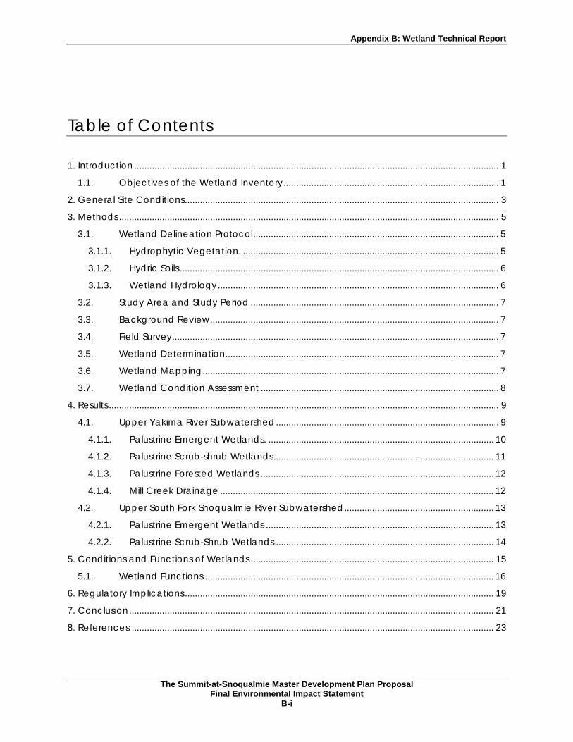
1. Introduction ................................................................................................................................................ 1
1.1. Objectives of the Wetland Inventory..................................................................................... 1
2. General Site Conditions............................................................................................................................ 3
3. Methods ...................................................................................................................................................... 5
3.1. Wetland Delineation Protocol................................................................................................. 5
3.1.1. Hydrophytic Vegetation. ..................................................................................................... 5
3.1.2. Hydric Soils .............................................................................................................................. 6
3.1.3. Wetland Hydrology............................................................................................................... 6
3.2. Study Area and Study Period .................................................................................................. 7
3.3. Background Review.................................................................................................................. 7
3.4. Field Survey................................................................................................................................. 7
3.5. Wetland Determination............................................................................................................ 7
3.6. Wetland Mapping..................................................................................................................... 7
3.7. Wetland Condition Assessment .............................................................................................. 8
4. Results .......................................................................................................................................................... 9
4.1. Upper Yakima River Subwatershed........................................................................................ 9
4.1.1. Palustrine Emergent Wetlands. ......................................................................................... 10
4.1.2. Palustrine Scrub-shrub Wetlands....................................................................................... 11
4.1.3. Palustrine Forested Wetlands ............................................................................................ 12
4.1.4. Mill Creek Drainage ............................................................................................................ 12
4.2. Upper South Fork Snoqualmie River Subwatershed........................................................... 13
4.2.1. Palustrine Emergent Wetlands .......................................................................................... 13
4.2.2. Palustrine Scrub-Shrub Wetlands ...................................................................................... 14
5. Conditions and Functions of Wetlands ................................................................................................ 15
5.1. Wetland Functions .................................................................................................................. 16
6. Regulatory Implications.......................................................................................................................... 19
7. Conclusion................................................................................................................................................ 21
8. References ............................................................................................................................................... 23

Appendix B: Wetland Technical Report
The Summit-at-Snoqualmie Master Development Plan Proposal
Final Environmental Impact Statement B-ii
List of Tables
Table 1. Plant Indicator Status Categories........................................................................................... 5
Table 2. Wetlands Identified Within the Summit at Snoqualmie Study Area .................................. 9
Table 3. King and Kittitas Counties Wetland Classification and Buffer Requirements ................ 20
Appendices
Appendix A Figures 1 through 3
Appendix B Common and Scientific Plant Names

Appendix B: Wetland Technical Report
The Summit-at-Snoqualmie Master Development Plan Proposal
Final Environmental Impact Statement B-1
1. Introduction
This report presents the results of the wetland inventory of wetlands subject to the jurisdiction of the U.S. Army Corps of Engineers (USACE) under Section 404 of the Clean Water Act of 1975 as amended in 1977, within the Study Area at The Summit at Snoqualmie (Summit West, Central, and East ski areas and Alpental). The Study Area is situated in the Cascade Mountain Range where I-90 intercepts the mountain range at Snoqualmie Pass (see Figure 1, Vicinity Map).
Booth Creek Resorts has presented a Master Development Plan (MDP) to the Mt. Baker-Snoqualmie National Forest (MBSNF) and the Okanogan Wenatchee National Forest (OWNF), which describes long-range (10 years) management, and development plans for The Summit at Snoqualmie ski areas (Sno.engineering 1998). The ski area operates partially on federally owned land under a Special Use Permit (SUP) administered by the MBSNF. Implementation of the MDP cannot occur until a NEPA review of the proposed action is complete. As part of that process, a watershed assessment is conducted to support the USFS Aquatic Conservation Strategy developed to restore and maintain the ecological health of watersheds. Wetlands, as defined by Section 404 of the Clean Water Act, are included as one of the water bodies that need to be addressed when applying the Aquatic Conservation Strategy to an action such as the Summit MDP.
This report presents the results of a wetland inventory for a Study Area that generally coincides with the MBSNF SUP area, Booth Creek Resort's private lands for the four ski areas (see Figures 2 and 3), and private lands within Section 21. Wetlands were identified using a combination of field reconnaissance surveys and review of aerial photographs and maps. The wetlands were identified using the criteria described in the 1987 Manual (Environmental Laboratory, 1987). The report was prepared to generally describe wetlands identified within the Study Area and to serve as a technical report that can be used to provide information during the preparation of the EIS for the MDP.
1.1. Objectives of the Wetland Inventory A wetland inventory was conducted within the Study Area, which is defined as the MBSNF SUP area and private lands at Alpental and Summit West, Central, and East ski areas and Section 21 using the 1987 Manual (Environmental Laboratory 1987). See Methods below for a full description of the methods used for the inventory. The objectives of the wetland inventory were to:
• Conduct an onsite wetland inventory of jurisdictional wetlands at major project areas.
• Identify potential wetlands in the remaining portion of the Study Area from National Wetland Inventory (NWI) maps and aerial photographs.
The intent of the wetland study was to focus on the proposed project areas within the Study Area. However, additional wetlands observed by field crews during stream surveys, or mapping of vegetation of the permit area, and wetlands identified from aerial photograph interpretation have also been included in the results and maps presented in this report.

Appendix B: Wetland Technical Report
The Summit-at-Snoqualmie Master Development Plan Proposal
Final Environmental Impact Statement B-3
2. General Site Conditions
The Study Area is located at Snoqualmie Pass and includes portions of the MBSNF (eastern King County) and the OWNF (western Kittitas County) as well as some privately owned land. The Study Area is situated in the Cascade Mountain Range with elevations ranging from approximately 3,000 to 4,900 feet above sea level. Within the Study Area, the Alpental ski area and the very northern edge of The Summit West ski area lie within the South Fork Snoqualmie watershed; the remaining portion of the Study Area (southern portion of Summit West, Summit Central, and Summit East and Section 21) occur in the Coal Creek Watershed east of the watershed break at the pass.
Average annual precipitation is 105 inches with approximately 44% of that amount occurring during December, January, and February. Average annual air temperature is 42oF and the average July temperature is approximately 59oF (Soil Conservation Service 1992).
The Study Area lies within the subalpine forest zone as identified by Franklin and Dyrness (1988). However, existing vegetation cover types identified as a part of the MDP NEPA process include a mixed conifer forest dominated by either mature or second-growth Pacific silver fir (Abies amabilis), mountain hemlock (Tsuga mertensiana), or western hemlock (Tsuga heterophylla). The South Fork Snoqualmie Watershed Analysis identifies a mix of late-successional forest and nonforested areas for the Alpental ski area (MBSNF 1995). The Summit West, Central, and East ski areas are a mix of mature forest and areas cleared for ski trails as identified in the Adaptive Management Area Plan DEIS (Wenatchee National Forest 1995). Timber harvest within Section 21 has modified vegetation as immature regeneration of Pacific silver fir and some mountain hemlock.
Shrub covered ski slopes have generally been cleared of forest tree species. Dominant shrubs on the ski slopes include huckleberries (Vaccinium spp.), salmonberry (Rubus spectabilis), vine maple (Acer circinatum), and stink currant (Ribes bracteosum). Ski slopes have also been seeded with a pasture grass mix that includes orchard grass (Dactylis glomerata), red fescue (Festuca rubra), perennial ryegrass (Lolium perenne), and red clover (Trifolium pratense).
The Soil Survey for Snoqualmie Pass Area, Parts of King and Pierce Counties, Washington (SCS 1992) identifies the following mapping units, and their associated taxonomic classification, for the mountain slopes in the Study Area:
• Altapeak gravelly sandy loam - Typic Cryorthods,
• Chinkmin sandy loam - Typic Cryohumods,
• Index loamy sand - Haplic Cryohumods,
• Reggad-Serene, 45-90% slopes - Typic Cryofolists - Humic Cryorthods, and
• Rock outcrop - Rubble land - Serene complex, 45-90% slopes, mixed Humic Cryorthods
None of these soils is included in Hydric Soils of the United States (SCS 1995), although small inclusions of hydric soils occur in depressions, seeps, and meadows as reported in the following section.
A soil survey with accompanying mapping unit descriptions for the Kittitas County area of the study site was not available. However, preliminary mapping of soils in the proposed project areas in Kittitas County by the NRCS are similar to those described for the King County survey because of similar parent material, slopes, aspects, and elevations.
Appendix B: Wetland Technical Report
The Summit-at-Snoqualmie Master Development Plan Proposal
Final Environmental Impact Statement B-5
3. Methods
3.1. Wetland Delineation Protocol To ensure consistency with federal, state, and local regulations, a wetland inventory was conducted of wetlands in the Study Area following the criteria described in the 1987 Manual. For regulatory purposes, wetlands are defined as: "areas that are inundated or saturated by surface or groundwater at a frequency and duration sufficient to support, and that under normal circumstances do support, a prevalence of vegetation typically adapted for life in saturated soil conditions. Wetlands generally include swamps, marshes, bogs, and similar areas" (CFR 328.3, 40 CFR 230.3).
To be under federal jurisdiction, a wetland must exhibit positive indicators for three mandatory diagnostic environmental characteristics, or technical criteria: vegetation, soil, and hydrology. "Hydrophytic vegetation", "hydric soil", and "wetland hydrology" are used in this report to refer to these three parameters. "Jurisdictional wetlands" refers to sites that meet the three technical criteria.
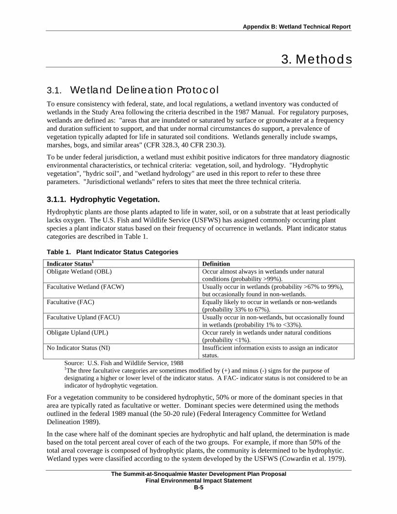
3.1.1. Hydrophytic Vegetation. Hydrophytic plants are those plants adapted to life in water, soil, or on a substrate that at least periodically lacks oxygen. The U.S. Fish and Wildlife Service (USFWS) has assigned commonly occurring plant species a plant indicator status based on their frequency of occurrence in wetlands. Plant indicator status categories are described in Table 1.
Table 1. Plant Indicator Status Categories
Indicator Status1 Definition Obligate Wetland (OBL) Occur almost always in wetlands under natural
conditions (probability >99%). Facultative Wetland (FACW) Usually occur in wetlands (probability >67% to 99%),
but occasionally found in non-wetlands. Facultative (FAC) Equally likely to occur in wetlands or non-wetlands
(probability 33% to 67%). Facultative Upland (FACU) Usually occur in non-wetlands, but occasionally found
in wetlands (probability 1% to <33%). Obligate Upland (UPL) Occur rarely in wetlands under natural conditions
(probability <1%). No Indicator Status (NI) Insufficient information exists to assign an indicator
status. Source: U.S. Fish and Wildlife Service, 1988 1The three facultative categories are sometimes modified by (+) and minus (-) signs for the purpose of designating a higher or lower level of the indicator status. A FAC- indicator status is not considered to be an indicator of hydrophytic vegetation.
For a vegetation community to be considered hydrophytic, 50% or more of the dominant species in that area are typically rated as facultative or wetter. Dominant species were determined using the methods outlined in the federal 1989 manual (the 50-20 rule) (Federal Interagency Committee for Wetland Delineation 1989).
In the case where half of the dominant species are hydrophytic and half upland, the determination is made based on the total percent areal cover of each of the two groups. For example, if more than 50% of the total areal coverage is composed of hydrophytic plants, the community is determined to be hydrophytic. Wetland types were classified according to the system developed by the USFWS (Cowardin et al. 1979).

Appendix B: Wetland Technical Report
The Summit-at-Snoqualmie Master Development Plan Proposal
Final Environmental Impact Statement B-6
"Dominant" is used to describe the prevailing vegetation composition of sites that are evaluated for jurisdictional status. Since the 1987 Wetlands Delineation Manual does not provide a method to determine dominant plant species, dominant status was determined using the methods in the Federal Manual for Identifying and Delineating Jurisdictional Wetlands (Federal Interagency Committee for Wetland Delineation 1989).
The plant communities in all of the wetlands identified for this inventory met the hydrophytic vegetation parameter, where more than 50% of the dominant plant species within each stratum are Obligate (OBL), Facultative Wetland (FACW), or Facultative (FAC).
The growing season for wetland vegetation was interpreted to be approximately 90 days. This is based on the U.S. Soil Conservation Service's (SCS) determination that the cryic soil temperature regime has been assigned to the soils in the Study Area (U.S. Soil Conservation Service 1993). The Natural Resources Conservation Service (NRCS), formerly the SCS, has also reported there are 90 to 120 frost-free days in the Snoqualmie Pass area (SCS 1993).
3.1.2. Hydric Soils Hydric soils are defined as those soils which are saturated, flooded, or ponded long enough during the growing season to develop anaerobic conditions that favor the growth and regeneration of hydrophytic vegetation. Determination of hydric soils in the project area was based on the direct observation of either direct evidence of flooding or ponding, or of the presence of the following hydric soil indicators:
• Chromas of 1 and 0 without mottles;
• Chromas of 2 or less with redoximorphic mottles;
• Histic epipedons or organic soils such as peat soil;
• Observed saturated soil indicating an aquic soil moisture regime; and
• Sulfidic smell indicating reduced soil conditions.
Soils were sampled with shovels and examined for hydric soil indicators. Soil pits were dug and examined for hydric soil characteristics (e.g. redoximorphic features). Soil colors were determined in the field using Munsell soil color charts (Munsell 1990), and soil texture was determined by hand texturing. Soil texture, color, and observation of plant fibers were used to estimate relative soil organic matter content.
3.1.3. Wetland Hydrology Wetland hydrology was based on field observations. Areas possessing wetland hydrology were inundated either permanently or periodically, or the soil was presumed to be saturated to the surface for sufficient time during the growing season to influence soil conditions and plant growth. Common wetland hydrology indicators observed during this field study included direct visual observation of inundated or saturated soil conditions, sediment deposits, wetland drainage patterns, water stained leaves, watermarks, oxidized root channels (i.e. rhizospheres), and drift lines.
The duration of inundation or saturation could not be determined during the survey period. However, the determination that a seasonally wet area exhibited wetland hydrology characteristics for a sufficient period to be considered a wetland was based on (1) whether positive wetland hydrology indicators were observed, and (2) an interpretation of the vegetation patterns, topography, and landscape position at the site. This method was used to distinguish between seasonally wet areas supporting wetland plant growth and the drainages, swales, or depressions that may be temporarily ponded, flooded, or saturated for very short periods.

Appendix B: Wetland Technical Report
The Summit-at-Snoqualmie Master Development Plan Proposal
Final Environmental Impact Statement B-7
3.2. Study Area and Study Period The Study Area includes the USFS ski permit areas for the Alpental and The Summit ski areas, private land owned by Booth Creek Resorts, and other private landholders (e.g. Plum Creek and Mountaineers, Inc.). As previously mentioned the field surveys were focused at those areas where proposed MDP projects (e.g. chairlifts, ski trails, and buildings) would occur. Aerial photography interpretation and observations of other wetlands during surveys for streams and vegetation cover identified wetlands in other portions of the Study Area. See Figure 1 for Study Area boundaries.
Jones & Stokes wetland biologists conducted field surveys on September 22, 23, 28, and 29, and October 4 and 5 1994; October 18, 1995; October 11, 1996; September 11, 22, 23, 24, and October 16, 1997; August 28, 31, and September 1 and 11, 1998; September 2 and 3, 1999; August 5 and 6, 2002; and October 3 and 4, 2003. Jones & Stokes and SE Group conducted wetland inventories in the Study Area in 2002 and 2003.
3.3. Background Review Before conducting the onsite investigations, Jones & Stokes wetland biologists reviewed color aerial photographs, and the Soil Survey of Snoqualmie Pass Area, Parts of King and Pierce Counties, Washington (SCS 1993).
3.4. Field Survey Wetlands at the proposed MDP project areas in the Study Area were based on the presence of wetland vegetation, indicators of wetland hydrology, and indicators of hydric soils. Methods used to identify wetland vegetation, hydrology, and soils are described below. Because of the project size and design phases, a reconnaissance level field approach was used in those areas where specific project designs have not yet been completed.
Wetlands in the Mill Creek subwatershed were identified using Wenatchee National Forest GIS data, aerial photo interpretation, and field reconnaissance. Field inventories focused on wetlands in proposed MDP project areas in the Backside drainage; in the northwest, northeast, and southeast portions of Section 21; those mapped by the Forest Service, and other wetlands observed.
3.5. Wetland Determination A wetland determination for a site was made by establishing plots which were sampled and evaluated for the three wetland parameters (vegetation, soils, and hydrology). A wetland or upland determination was made for each plot. Wetland boundaries for an area were determined based on plot determinations and visual observations of site characteristics with similar vegetation and hydrology conditions.
Wetlands are regulated by the U.S. Army Corps of Engineers (Corps) under Section 404 of the Clean Water Act and by local jurisdictions under sensitive areas ordinances. Final determination of wetland jurisdictional boundaries is the responsibility of the Corps. Wetland verification by the Corps would occur prior to implementation of any of the proposed MDP elements.
3.6. Wetland Mapping Wetland locations and configurations were drawn on color aerial photographs (scales of 1:4,800 and 1:2,000) and transferred to 1:4,800 scale topographic maps with 20-foot contours. [WNF wetlands mapped on 1 inch = 400 foot topographic maps. Reconnaissance level surveys identified wetlands in most of the proposed project sites with more detailed wetland inventory conducted at the proposed snow
Appendix B: Wetland Technical Report
The Summit-at-Snoqualmie Master Development Plan Proposal
Final Environmental Impact Statement B-8
play area.] Wetland information collected in the field was digitalized and converted into GIS shape files and database files. The wetland data was then corrected by correcting locational features from non-orthographically correct aerial photos and applying them to consistent topographic base mapping.
Wetlands in other portions of the Study Area were mapped using aerial photographs, field observations while walking from one project area to another area, and observations made during stream characterization field surveys. Wetlands identified in the Mill Creek drainage were delineated on aerial photos and maps for automation in the project GIS.
3.7. Wetland Condition Assessment The condition of the wetlands delineated in the Study Area was qualitatively assessed based on (1) the amount of disturbance in the wetland or its buffer, and (2) the value that the functions of the wetland may be providing. Criteria used to evaluate the functions for the wetland are those suggested by wetland scientists as a means to evaluate wetland functions (Cooke 1996)

Appendix B: Wetland Technical Report
The Summit-at-Snoqualmie Master Development Plan Proposal
Final Environmental Impact Statement B-9
4. Results
A total of 227 wetlands with a combined area of 72.29 acres have been identified in areas surveyed within the Study Area of The Summit at Snoqualmie and portions of Section 21. Of these, a total of 208 wetlands (or complex of wetlands) were identified in the field and an additional 19 wetlands were mapped from aerial photographs. Wetlands within the Study Area were classified using vegetation classes based on the USFWS wetland classification system (Cowardin et al., 1979), and by whether they are currently in natural or modified condition. Results of the wetland inventory within the Study Area are summarized in Table 2. These results are based on the record of wetland conditions contained in the GIS database compiled for the environmental analysis for the proposed MDP. The abundance and distribution of wetlands identified in the Study Area are displayed in Figures 2 and 3, at the end of this report. Table 4, also at the end of this report, lists the common and scientific plant names used in this report.
Table 2. Wetlands Identified Within the Summit at Snoqualmie Study Area
Upper Yakima Upper South Fork Snoqualmie
Study Area Totals Wetland Type/Terrain Management
Number Acres Number Acres Number Acres Palustrine Emergent Natural 36 11.41 17 1.42 53 12.84 Modified 82 27.81 27 7.11 109 34.92 Palustrine Scrub-Shrub Natural 23 3.98 2 0.04 25 4.02 Modified 33 17.19 4 0.65 37 17.84 Palustrine Forested Natural 3 2.68 0 0.00 3 2.68 Modified 0 0.00 0 0.00 0 0.00 Total (all wetlands) 177 63.06 50 9.23 227 72.29 Total Natural Wetlands 62 18.07 19 1.47 81 19.54 Total Modified Wetlands 115 44.99 31 7.76 146 52.75
Wetlands are presented in this report according to the upper Yakima River subwatershed and the upper South Fork Snoqualmie (SFS) subwatershed. Wetlands identified within the Mill Creek drainage are included in the totals presented for the upper Yakima subwatershed (Table 2); however, a brief discussion of wetlands is provided for the Mill Creek drainage as a subset to the upper Yakima subwatershed. The ecological characteristics of these subwatersheds are described further in Chapter 6 of the Upper South Fork Snoqualmie River and Coal Creek Watershed Condition Assessment (Jones & Stokes, 2001) and the Mill Creek Watershed Condition Assessment (Jones & Stokes and SE GROUP, 2003).
Because of the numerous wetlands found in the Study Area, wetland vegetation, hydrologic and soil conditions, and wetland functions are summarized below for wetland groups with similar conditions.
4.1. Upper Yakima River Subwatershed Wetlands located in this subwatershed include those identified within the Summit West, Summit Central, and Summit East ski areas. Wetlands were also identified within the Mill Creek drainage and are discussed below. This area encompasses portions of the Coal subwatershed, and the West Beaver, Ski Acres, Hyak-Tunnel, Creek Run, and Summit South drainages. A total of 177 wetlands totaling 63.06 acres were identified within the Study Area in the upper Yakima subwatershed. Of the 177 wetlands, 115 wetlands (44.99 acres) occur on areas modified by land management, while 62 (18.07 acres) exist in a

Appendix B: Wetland Technical Report
The Summit-at-Snoqualmie Master Development Plan Proposal
Final Environmental Impact Statement B-10
natural condition. Many of these wetlands have been modified by ski trail development and disturbance associated with ongoing maintenance activities (mowing) and land uses such as roads, parking lots, and hiking and biking trails. Timber harvest may have affected some of the wetlands prior to the development of the ski areas.
4.1.1. Palustrine Emergent Wetlands. There are 118 palustrine emergent wetlands in the Study Area within the upper Yakima subwatershed (two-thirds of all wetlands surveyed in this portion of the Study Area). Of these, 82 palustrine emergent wetlands, covering 27.81 acres, occur in areas modified by land management. Some of these wetlands were likely created when regrading for ski trail development exposed subsurface flows.
Of the 18.07 acres of natural wetland area identified in this portion of the Study Area, approximately 11.41 acres (63 percent) are emergent wetlands. These wetlands occur in natural conditions in open meadows, openings in the forest canopy, subalpine areas, at lake edges as wetland fringe, and along some streams at the base of the slopes. The wetlands generally are not associated with large wetland complexes, except for the wetland complex (collectively, approximately 7.5 acres) located in the base area in Summit Central between SR906 and I-90.
Vegetation. Vegetation in emergent wetlands occurring on areas modified and maintained as ski trails and in other disturbed areas are typically dominated by a mix of nonnative grasses such as orchardgrass and bentgrass (Agrostis sp.) and sedges (Carex spp.). The common sedges included showy (C. spectabilis), short-scale (C. deweyana), and Merten’s (C. mertensii). Other widespread plant species observed include soft rush (Juncus effusus), dagger-leaf rush (J. ensifolius), and small-fruited bulrush (Scirpus microcarpus). Marsh marigold (Caltha biflora) and common horsetail (Equisetum arvense) were also observed. Some wetlands located in modified areas are also dominated by lady fern (Athyrium filix-femina), skunk cabbage (Lysichitcum americanum), and deer fern (Blechnum spicant). Occasionally, shrubs such as spirea (Spiraea douglasii) and salmonberry are scattered throughout the emergent wetland or flank the wetland edge. Common upland plants typically include species such as bracken fern (Pteridium aquilinum), pearly-everlasting (Analphalis margaritacea), goldenrod (Solidago Canadensis), and fireweed (Epilobium angustifolium).
Dominant wetland plants vary between the naturally occurring wetlands but common species include blue-joint reedgrass (Calamagrostis canadensis), sedges, dagger-leaf rush, and soft rush. Other herbaceous species that are dominants in some wetlands include marsh marigold, deer fern, lady fern, small-fruited bulrush, and bentgrass. The upland species also vary according to where the emergent wetland occurs, and can be comprised of meadow, shrub, or forested species common to the Study Area.
A few emergent wetlands in a natural condition are considered bogs because of the presence of Sphagnum moss (Sphagnum sp.), scattered individuals of leafy white bog orchid (Plantanthera dilatata), and a peat soil. Other plants include few-flowered spike-rush (Eleocharis pauciflora ), cottongrass (Eriophorum sp.), beaked sedge (Carex utriculata), water sedge (Carex aquatilis), elephant’s head (Pedicularis groendlandica), and Labrador-tea (Rhododendron groenlandicum). One such bog harbors a population of swamp gentian (Gentiana douglasiana), a USFS sensitive vascular species.
Hydrology. The majority of emergent wetlands identified in this portion of the Study Area are slope wetlands, generally located in the middle and upper portions of the Study Area (Figure 1). Slope wetlands are generally hillside seeps characterized by a groundwater hydrology source, unidirectional flow of water through the wetland and usually occur on bench terraces. The primary hydrological input to the slope wetlands is a shallow-sub-surface groundwater flow that discharges at or near the surface in response to breaks in slope, slope failures, or changes in soil composition. These seeps often percolate back into the soil or ultimately drain into small streams. Some of the wetlands on modified slopes were likely created when regrading removed surface soils that exposed groundwater to support surface wetland

Appendix B: Wetland Technical Report
The Summit-at-Snoqualmie Master Development Plan Proposal
Final Environmental Impact Statement B-11
hydrology. Other wetlands are seasonally saturated moist and wet meadows, or are located in isolated depressions where movement of surface water is slowed and retained. These swale-like wetlands are usually not connected to other wetlands or streams.
Wetland hydrology indicators included direct observation of inundation or saturation of soils in the upper 12 inches of the soil profile, sediment deposition, and drainage patterns within the wetlands.
Soils. Wetlands at The Summit are in an area similar to the Chinkman soil mapping unit mapped for the Alpental area. The wetlands are generally too small to map as separate soil mapping units, and are considered inclusions of that upland mapping unit. Wetland soil conditions were assumed to be present based on different indicators of hydric soils. A sulfidic odor, indicating saturated soil conditions, was observed at many of the wetlands where soil was sampled. Other indicators of hydric soils include low chroma soil matrix colors (e.g. 10YR 2/1 and 10YR 3/1) and redoximorphic features. Organic muck or peat was observed at some of the wetlands. The composition of mineral soils observed in modified wetlands ranged from sandy loams to loams. Some of the wetlands in The Summit area have very shallow soils that appear to be subsurface soils based on color and minimal accumulation of organic content in the profile.
4.1.2. Palustrine Scrub-shrub Wetlands A total of 33 palustrine scrub-shrub wetlands in modified condition, covering 17.19 acres, were identified within the Study Area in the upper Yakima subwatershed. Scrub-shrub wetlands on slopes modified for skiing are small, generally less than 0.1 acre. Twenty-three palustrine scrub-shrub wetlands in natural condition, covering 3.98 acres, were identified within the Study Area in the upper Yakima subwatershed.
Vegetation. Scrub-shrub wetlands in modified areas maintained as ski trails are not common. However, those observed were dominated by Sitka alder (Alnus sinuata), Sitka willow (Salix sitchensis), subalpine spirea (Spiraea densiflora), and salmolnberry. Understory species observed included reed canarygrass (Phalaris arundinacea), skunk cabbage, small-fruited bulrush, and sedge. Huckleberry (Vaccinium spp.), false azalea (Menziesia ferruginea), and salmonberry are common in the upland adjacent to the wetland.
Scrub-shrub wetlands in relatively undisturbed areas are dominated by similar shrub species as the wetlands in modified areas. The scrub-shrub wetlands are generally located in swale-like areas where surface water collects. Salmonberry is the most common shrub species; other shrub species that dominate some wetlands include Sitka alder, devil's club (Oplopanax horridum), or stink currant. Understory species that may be present include skunk cabbage, small-fruited bulrush, blue-joint reedgrass, and lady fern. Vine maple is a common upland species in the area adjacent to undisturbed scrub-shrub wetlands. Conifer species, such as mountain hemlock are rooted in the upland of some of the scrub-shrub wetlands.
Hydrology. Similar to the hydrology supporting emergent wetlands, these wetlands are typically controlled by seasonally high groundwater seeps regardless of slope position, including mountain slopes, benches, and narrow valley bottoms. Surface water associated with the seep typically submerges back into the soil at the wetland boundary or is discharged downslope in an associated drainage. Scrub-shrub wetlands and small scrub-shrub areas within some of the emergent wetlands are typically associated with streams draining through the wetlands. Scrub-shrub wetlands are also often found along constructed drainage ditches.
Soils. All the wetlands are in an area similar to the Chinkman soil mapping unit described for the Alpental area. The wetlands would be hydric inclusions within that upland mapping unit. Hydric soils would be similar to those described for emergent wetlands. Hydric soil conditions were assumed to be present based on an apparent aquic soil moisture regime. Hydric soil indicators include a sulfidic odor, low-chroma colors, and mottles. Soil textures are generally loam and sandy loam.

Appendix B: Wetland Technical Report
The Summit-at-Snoqualmie Master Development Plan Proposal
Final Environmental Impact Statement B-12
4.1.3. Palustrine Forested Wetlands Three palustrine forested wetlands in natural condition, totaling 2.68 acres, were identified in this portion of the Study Area (Mountaineers and SR 906/I90 area) and are the rarest wetland type surveyed.
Vegetation. Forested wetlands are located in mixed conifer forest dominated by mountain hemlock, Pacific silver fir, with some western red cedar (Thuja plicata) present. Upland understory plants include huckleberry and false azalea, and other plants that are considered wetland indicator species such as salmonberry, bunchberry (Cornus canadensis) deer fern, and oak fern (Gymnocarpium dryopteris) (Reed 1988).
Hydrology. These wetlands are situated on large, generally flat areas. Surface water was observed in portions of the wetland and the soils were saturated to the surface. The source of water is likely a combination of surface and subsurface runoff that collects in the large flat areas with a relatively impervious subsurface material to inhibit recharge of water back into the subsoil.
Soils. These wetlands are located in an area similar to the Chinkman soil mapping unit and would be hydric inclusions of that upland mapping unit. Hydric soil conditions were based on an apparent aquic soil moisture regime. A sulfidic odor, indicating reduced conditions, was observed at the wetlands where soils were sampled. These wetlands included some areas with organic soils. Other indicators of hydric soils included low chroma soil colors (10YR 3/1) or low chroma soil matrix colors with redoximorphic features (e.g. 7.5YR 3/2 matrix with 10YR ¾ mottles and 10YR 3/2 matrix with 10YR 4/6 mottles).
4.1.4. Mill Creek Drainage A total of 41 wetlands, covering approximately 33.9 acres were identified in the areas surveyed within the Mill Creek drainage. These wetlands are included in the totals presented above for the Study Area within the upper Yakima subwatershed. Wetlands were specifically assessed in the Mill Creek drainage because this land could potentially be purchased by Booth Creek Resorts and donated to the USFS to be managed as late-successional habitat. A separate report includes detailed discussion of wetlands within the Mill Creek subwatershed (Jones & Stokes and SE GROUP, 2003).
Wetlands identified are primarily palustrine emergent wetlands (14.8 acres, 44%) and palustrine scrub-shrub wetlands (16.1 acres, 47%). Nearly all wetlands identified are situated within the lower and upper Mill Creek drainages as depressional isolated or depressional headwater wetlands. The wetlands range from 0.01 to 4.3 acre in size, with half of them being less than 0.25-acre in size. Of the 33.9 acres of wetland area identified, 23.7 acres occurs in a modified condition and 10.2 acres occurs as natural wetland area.
The five largest wetlands compose 39 percent of the wetland area in the subwatershed, and include:
• A 4.3-acre emergent wetland situated in the upper Mill Creek drainage whose buffer includes both mature forest and sapling forest;
• A 2.6-acre emergent wetland in the lower Mill Creek drainage whose buffer is in sapling conifer forest;
• A 2.2-acre scrub-shrub wetland in the lower Mill Creek drainage whose buffer is in sapling conifer forest;
• A 2.1-acre emergent wetland in the upper Mill Creek drainage whose buffer is in mature forest; and
• A 2.1-acre emergent wetland in the lower Mill Creek drainage whose buffer is in mature forest.

Appendix B: Wetland Technical Report
The Summit-at-Snoqualmie Master Development Plan Proposal
Final Environmental Impact Statement B-13
Palustrine emergent wetland acreage within the Mill Creek drainage is nearly evenly divided between modified (8.2 acres) and natural (6.6 acres) settings. Much of the modified wetland acreage surveyed during this inventory is associated with the timber harvest units in the lower Mill Creek drainage. Marsh marigold, deer fern, soft rush, and small-fruited bulrush are common emergent wetland plants in these modified areas. Wetlands observed in an undisturbed, natural condition are in the upper Mill Creek drainage. Dominant vegetation in emergent wetlands in a natural condition includes narrow-leaved cotton-grass (Eriophorum angustifolium), lady fern, corn lily (Veratrum viride), orchid (Platanthera sp.), sedges and Sphagnum moss.
The majority (15.5 acres) of palustrine scrub-shrub wetlands identified are located in areas modified by harvest activities or removal of trees and shrubs for maintenance of ski trails (i.e. old Backside Chair). Dominant vegetation in the scrub-shrub wetlands includes Sitka alder, Sitka willow, and subalpine spirea. Most of these wetlands are associated with small perennial drainages. There is 0.6-acre of palustrine scrub-shrub wetland that remains in a natural condition.
Wetlands mapped in harvested areas have been disturbed through the removal of overstory trees; however, vegetation has been allowed to reestablish and many of the wetlands in this area have remained as natural emergent or scrub-shrub wetlands that originally were located in forest openings. Road construction may have resulted in the interception and channeling of some wetland seeps; in other areas roads may have created wetland seeps through the interception of shallow groundwater.
4.2. Upper South Fork Snoqualmie River Subwatershed Wetlands located in this subwatershed include those identified within the Alpental ski area and a small portion of the northern part of the Summit West ski area. This area encompasses portions of the Source Lake subwatershed, and the International, Upper Alpental, Upper South Fork Snoqualmie, and Summit North drainages. Fifty wetlands totaling 9.23 acres were identified in this portion of the Study Area. Thirty-one of the wetlands are located in areas modified and maintained for ski facilities and trails. Nineteen wetlands, totaling 1.47 acres, are located in natural openings in the forest canopy or in a subalpine setting.
4.2.1. Palustrine Emergent Wetlands Forty-four of the wetlands in the upper South Fork Snoqualmie subwatershed are palustrine emergent wetlands. Twenty-seven of these wetlands are located in areas modified and maintained as ski trails. Except for one wetland, all emergent wetlands identified in modified areas are small wetlands varying in size from approximately 0.01 (or smaller) to 0.6 acre. The largest emergent wetland is approximately 2.85 acres and located on the St. Bernard ski trail at the Alpental ski area.
Vegetation. Wetlands in modified condition on slopes maintained as ski trails are dominated by grasses, rushes, and sedges that include blue-joint reedgrass, bentgrass, reed canarygrass, soft rush, dagger-leaf rush, and showy sedge (Carex spectabilis). Other wetlands, including the large wetland in the base area, are also dominated by small-fruited bulrush and sticky tofieldia (Tofieldia glutinosa). Some Sitka alder and spirea shrub cover is also present although it is cut to maintain the area for skiing. The large wetland is in a degraded condition because of the mowed vegetation and ditches that have been maintained in the wetland. The ditches are part of the drainage system used to carry surface water away from the wetland to prevent a ski trail access road from washing out and to direct surface water to culverts and around adjacent parking areas.
Emergent wetlands located in natural forest openings or in subalpine areas are dominated by alpine sedge (Carex nigricans) and other sedges, dagger-leaf rush and other rushes (e.g. Juncus spp.), marsh marigold, and lady fern. Wetlands on upper slopes in subalpine areas occur as small wet meadows or as a fringe of wetland around small open water ponds. Portions of one of the wetlands is considered a bog because of

Appendix B: Wetland Technical Report
The Summit-at-Snoqualmie Master Development Plan Proposal
Final Environmental Impact Statement B-14
the presence of sphagnum moss and organic soils. Dominant herbaceous vegetation at this wetland includes marsh marigold, dagger-leaf rush, sedges, and blue-joint reedgrass.
4.2.2. Palustrine Scrub-Shrub Wetlands Six scrub-shrub wetlands (0.69-acre) were identified in this subwatershed, with four (0.65 acre) occurring in areas modified for ski trails. Scrub-shrub wetlands are small in size, less than 0.1 acre.
Vegetation. These wetlands are dominated by salmonberry and/or devil's club. Other shrub species that are present include shiny leaf spirea (Spiraea betulifolia) and subalpine spirea. In some areas of the scrub-shrub wetland herbaceous vegetation (e.g., lady fern and deer fern) is present where the scrub-shrub layer does not form a dense continuous canopy. Scrub-shrub wetlands with these species are located in areas modified and maintained as ski trails and in naturally occurring openings on the mountain slopes.
Hydrology. Most of the wetlands are located on either backslope, footslope, or toeslope landscape positions and are associated with shallow groundwater discharge zones as seeps. Soils in the wetlands were generally either saturated to the surface or in the upper 12 inches during the time of sampling in late September and early October. Shallow surface water was observed in those wetlands that appear to be perennially wet. Surface water from the wetland seeps was observed to either submerge back into the soil at the wetland boundary, or in several wetlands continued downslope in an associated ditch or stream. Wetland hydrology at some wetlands is associated with the saturated soil conditions adjacent to ponded water. Some wetlands are depressional wetlands that collect surface water runoff and appear to be isolated or in landscape positions above the headwaters of adjacent streams. Wetland area may also be associated with the South Fork Snoqualmie if surface water from snow melt or rainstorms flows through the wetland and directly into the stream.
Soils. All of the wetlands are located in either Chinkman, Index, or Altapeak mapping units. These are upland soils and the wetlands would be small hydric inclusions. Indicators of hydric soil conditions included presence of either (1) an aquic soil moisture regime in the saturated soils, (2) sulfidic smell which indicates reduced conditions exist, or (3) low chroma soils (e.g. 10YR 2/1) and low chroma soils with mottles (7.5YR 3/2 with 10YR 3/4 mottles).

Appendix B: Wetland Technical Report
The Summit-at-Snoqualmie Master Development Plan Proposal
Final Environmental Impact Statement B-15
5. Conditions and Functions of Wetlands
Two Hundred Twenty-Seven wetlands totaling 72.29 acres were identified in the Study Area. The majority of wetlands identified within the Study Area are small (less than 0.25 acre) palustrine emergent or scrub-shrub wetlands. These wetlands are scattered throughout the Study Area, with over 70 percent occurring in areas modified by land management.
Eleven larger wetlands comprise approximately 25 percent of the total wetland acreage. The large emergent wetland at Alpental and one of the wetlands below the Summit Central ski area have some level of disturbance from ski development. However, the three wetlands below the Summit Central ski area are relatively undisturbed from ski development. As previously mentioned in this report, portions of this wetlands series are considered bogs. Bogs are considered a unique and significant wetland type by the Ecology and the USFS.
Using Ecology's wetland rating system for Washington (Ecology 1993) only a few of the larger wetlands would be considered Category I wetlands (i.e., wetlands considered to be of the highest quality). These are the relatively large wetlands (1 to 5 acres in size), located in a relatively undisturbed area, having multiple wetland vegetation classes and high plant species diversity. The presence of bogs further enhances the value of a wetland.
Most wetlands within the Study Area would be considered Category III wetlands because of their relatively small size, the wetlands are typically represented by a single wetland vegetation class, the wetland's isolated nature or connection to a small drainage, and for those wetlands in modified areas maintained as ski trails or along parking lots and roads, and the amount of surrounding disturbance.
None of the wetlands are considered Category IV wetlands. Category IV wetlands are dominated by nonnative wetland plants. For the Study Area, all of the wetlands have native plant species that are considered dominant species.
Numerous wetlands occur in modified areas maintained as ski trails or along roadside ditches. A total of 146 wetlands (64% of the total number of wetlands) are located within areas maintained for ski runs, lift lines, along roads, or in areas modified by timber harvest. Total acreage of these wetlands is 52.75 acres or 73% of the total wetland acreage. The wetlands located in ski trails or lift lines are considered to be in a lower condition class because of the clearing, regrading, and low plant species diversity in the wetlands and the disturbance to the surrounding buffers from ski development. Low plant diversity between the wetlands on ski trails also indicates a lower level of unique wetland features on the ski trails.
Some of the wetlands on ski slopes were likely created when regrading removed surface soils and to expose groundwater to support surface wetland hydrology. Some of the wetlands on the Summit ski area have very shallow soils of several inches that appear to be subsurface soils based on color and minimal accumulation of organic content in the soil.
Some wetlands in the base areas have been disturbed by ditches dug adjacent to or through the wetland, and access roads and/or storage debris piles placed in or near the wetlands. Ditching through the wetland could affect groundwater level in the wetland by slightly lowering groundwater levels within the lower portion of the wetland during the late summer. Sediment delivery to these wetlands occurs from bank erosion or sloughing of material into ditches, Widening of the ditch from bank erosion could also reduce the amount of naturally vegetated area within the wetland.
The area immediately adjacent to all wetlands is referred to as the wetland buffer. Wetland buffers within the ski areas are dominated by upland vegetation, including the common conifer forest species (Pacific silver fir, western hemlock, and mountain hemlock) or herbaceous and shrub species. The
Appendix B: Wetland Technical Report
The Summit-at-Snoqualmie Master Development Plan Proposal
Final Environmental Impact Statement B-16
wetland/upland boundary is generally a distinct, abrupt boundary because of topographic and hydrologic conditions. A broad transition from wetland species to upland or riparian species is not generally associated with these wetlands. Salmonberry and Sitka alder are commonly seen in scrub-shrub wetlands and many upland areas (in ski trails and in the forested or non-cleared areas) and represent two shrub species that are associated with more moist environments that are not jurisdictional wetlands.
5.1. Wetland Functions Wetlands provide a variety of functions that are dependent on many factors such as the size of the wetland, topography, geology, hydrology, types and distribution of habitat present, condition of adjacent upland, and disturbance history.
The small size of most of the wetlands in the Study Area and their location in the context of a high summer and winter recreational use area limit the value of many of the wetlands relative to the functions commonly associated with wetlands. The functions of the wetlands located in modified areas on ski trails in the Alpental and Summit ski area are limited because of their small size and the developed nature of the ski area. The primary functions provided by wetlands on ski trails include habitat support for several native wetland plant species and, in some cases, baseflow to small streams. Wetlands that are associated with a stream can provide some baseflow support to the stream if groundwater discharge that is supporting the wetland flows through the wetland and into the stream. Based on the criteria (Cooke 1996), small wetland less than once acre in size, and located in the upper watershed would have functions that would receive a low rating.
The functions of undisturbed wetlands can be limited by their size and surrounding land use. However, these wetlands generally provide low to moderate water quality improvement as well as moderate stream baseflow support. For example, undisturbed wetlands may retain sediment from adjacent ski trails, roads, or parking lots. Emergent wetlands provide natural biological support, and if associated with a stream can provide organic input to streams that can be used by aquatic invertebrates which provide a food base for other vertebrates (fish, amphibians, etc.). Scrub-shrub and forested communities provide greater plant community structure used by birds and other animals.
As depressional and slope wetlands within forested habitat or along perennial streams, many of the wetlands in Mill Creek provide functions such as attenuating surface runoff, sediment filtration, plant community structure for aquatic and terrestrial wildlife habitat and stream shading, and detritus and nutrient input to streams. Despite their small size, their position in headwaters and riparian settings make them groundwater discharge sites critical to the sustaining of baseflows within the subwatershed.
Wetland functions associated with wetlands in the forested areas surrounding the developed ski areas can be summarized as follows:
• Stream base flow support - moderate rating as most of the wetlands that are associated with drainages are small and wetlands associated with intermittent or perennial streams can support stream flow as groundwater flows through the wetland to the stream.
• Water quality improvement - low to moderate rating because of the small size of wetlands. Many wetlands are located on slopes that increases the flow through time of runoff through the wetland. Some of the wetlands can act as sites for sediment accumulation although this has not been observed as a significant feature in most of the wetlands. A few of the wetlands do accumulate sediment from adjacent ski trails, roads or parking lots.
• Natural biological support - Low to moderate rating. Support of biological communities depends on the production of plant material (primary production) that can be consumed by herbivores which in turn are consumed by carnivores. Emergent wetlands, with greater herbaceous plant growth, provide greater biological support than scrub-shrub wetlands. Wetlands associated with
Appendix B: Wetland Technical Report
The Summit-at-Snoqualmie Master Development Plan Proposal
Final Environmental Impact Statement B-17
streams can provide some primary production to the stream in the form of foliage and other organic material falling or washing into the stream. This material can then be consumed by aquatic invertebrates, which are in turn consumed by fish and other vertebrate animals. Therefore, wetlands associated with streams rate low to moderate in natural biological support function. (Those wetlands with bogs present could be rated moderate to high because of the unique plant species typically associated with bog wetlands.)
• Habitat functions - Because many of the wetlands are small in size, having a single habitat type, and there is high human use of this area in summer and winter, the wildlife habitat functions specific to the wetlands are generally low to moderate. Wetlands with surface water can provide a source of water for amphibians and mammals. Pacific giant salamander, tailed frog, and cascade frogs have been observed in some of the stream side habitats and could likely be associated with wetlands. Eggs for northwestern larvae were observed at one of the wetlands.
Appendix B: Wetland Technical Report
The Summit-at-Snoqualmie Master Development Plan Proposal
Final Environmental Impact Statement B-19
6. Regulatory Implications
Several federal, state, and local regulations can apply to wetlands. Agencies having jurisdiction over wetlands include the U.S. Army Corps of Engineers (USACE), the Washington Department of Ecology, and the Washington Department of Fish and Wildlife (WDFW). Wetland determinations are subject to verification and approval by agencies. Wetland regulatory decisions and permitting determinations can only be made by the regulatory agencies.
The USACE regulates the discharge of dredge and fill material into wetlands and waters of the United States through Section 404 of the Clean Water Act as amended in 1977. If a proposed project involves temporary or permanent filling of wetlands or other water bodies, including intermittent drainages, a USACE Section 404 permit may be required. The USACE makes the final determination as to whether the area meets the definition of a jurisdictional wetland and whether the wetland is “isolated” from or “adjacent” to other water bodies. The USACE and U.S. Environmental Protection Agency (EPA) have amended their permit regulations defining discharges of dredged material and fill material (58 FR 45008, August 25, 1993). The regulations now include excavations of wetlands where incidental discharge occurs.
The USACE has established two types of permit programs under Section 404 of the Clean Water Act which apply to wetland fill proposals—nationwide permit or individual permit—in accordance with the nature of the proposed fill activity and the amount of impact. After notification, the USACE will coordinate with the EPA, the U.S. Fish and Wildlife Service, Ecology, the Washington Department of Natural Resources, the WDFW, and other appropriate state agencies, and either issue an authorization to proceed under an nationwide permit, or give notice that an individual permit is required. A Hydraulic Project Approval (HPA) would be required by the WDFW for any work within a wetland associated with the ordinary high water mark of fresh waters of the state (Chapter 75.20 RCW). The USACE and Ecology may require mitigation for wetland impacts under a nationwide permit.
Section 401 of the federal Clean Water Act directs each state to certify that proposed in-water activities requiring a Section 404 permit would not adversely affect water quality or violate state aquatic protection laws. The Washington Department of Ecology is responsible for administering Washington State’s certification program. For any discharge of dredge or fill material in wetlands, an application for water quality certification from Ecology is required.
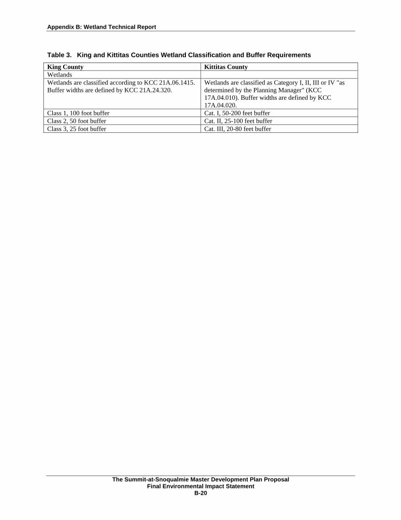
Wetlands occurring on private land are subject to the same federal and state jurisdictional authorities as those within public land. However, wetlands on private land also fall under local regulation provided by the County (Kittitas County Code 17A.04.010 and King County Code 21A.24). Kittitas and King Counties regulate wetlands and designate wetland buffers for wetlands located on privately owned land within their respective jurisdictions (Table 3). Wetland ratings would be based on criteria from the Washington State Wetlands Rating System for Western Washington (and Eastern Washington) developed by the Washington Department of Ecology. The rating systems are used by the Counties to determine restrictions on activities in or adjacent to the wetland and its buffer, the appropriate buffer width, and mitigation requirements for allowable impacts. King and Kittitas Counties require the formal delineation of wetlands and mitigation of potential impacts to wetlands in coordination with permit approvals.
Appendix B: Wetland Technical Report
The Summit-at-Snoqualmie Master Development Plan Proposal
Final Environmental Impact Statement B-20
Table 3. King and Kittitas Counties Wetland Classification and Buffer Requirements
King County Kittitas County Wetlands Wetlands are classified according to KCC 21A.06.1415. Buffer widths are defined by KCC 21A.24.320.
Wetlands are classified as Category I, II, III or IV "as determined by the Planning Manager" (KCC 17A.04.010). Buffer widths are defined by KCC 17A.04.020.
Class 1, 100 foot buffer Cat. I, 50-200 feet buffer Class 2, 50 foot buffer Cat. II, 25-100 feet buffer Class 3, 25 foot buffer Cat. III, 20-80 feet buffer

Appendix B: Wetland Technical Report
The Summit-at-Snoqualmie Master Development Plan Proposal
Final Environmental Impact Statement B-21
7. Conclusion
A total of 227 wetlands, comprising a total area of 72.29 acres, were inventoried in the Study Area during the study period. The actual area of wetlands under the jurisdiction of the USACE may be less than the results stated in this report due to recent changes in the scope and interpretation of the definition of “waters of the U.S.” contained in the Clean Water Act (SWANCC vs. USACE, January 9, 2001). Therefore, field verification by the USACE would be required to determine the extent of jurisdictional wetlands within the Study Area and permitting requirements prior to implementation of the alternative selected by the U.S. Forest Service. All of the pertinent permits and approvals must be acquired from the appropriate federal, state, and local agencies prior to implementation of the selected alternative from the Final EIS.
Appendix B: Wetland Technical Report
The Summit-at-Snoqualmie Master Development Plan Proposal
Final Environmental Impact Statement B-23
8. References
Cooke S.S. 1996. Wetland and buffer functions semi-quantitative assessment methodology. Draft user's manual. Prepared by Cooke Scientific Services. Seattle, WA.
Cowardin, L. M., V. Carter, F. C. Golet, and E. T. LaRoe. 1979. Classification of wetlands and deep water habitats of the United States. (FWS/OBS-79/31.) U.S. Fish and Wildlife Service. Washington, DC.
Environmental Laboratory. 1987. U.S. Army Corps of Engineers wetlands delineation manual. (Technical Report 4-87-1.) U.S. Army Corps of Engineers Waterways Experiment Station. Vicksburg, MS.
Federal Interagency Committee for Wetland Delineation. 1989. Federal manual for identifying and delineating jurisdictional wetlands. January. U.S. Army Corps of Engineers, U.S. Environmental Protection Agency, U.S. Fish and Wildlife Service, and U.S. Soil Conservation Service. Washington, DC.
Franklin, J. F., and C. T. Dyrness. 1973. Natural vegetation of Oregon and Washington. Oregon State University Press. Corvallis, OR.
Jones & Stokes Associates. 1998. Upper South Fork Snoqualmie River and Coal Creek watershed condition assessment. Prepared for Booth Creek Resorts. Vail, Colorado.
_______. 2001. Upper South Fork Snoqualmie River and Coal Creek watershed condition assessment. Prepared in association with SE Group (Bellevue, WA). Prepared for Booth Creek Resorts.
_______. 2004. Mill Creek watershed condition assessment. Addendum, Upper South Fork Snoqualmie River and Coal Creek watershed condition assessment, 2001. Prepared in association with SE Group (Bellevue, WA). Prepared for Booth Creek Resorts.
Mt. Baker-Snoqualmie National Forest. 1994. Standard operations for plant program. Unpublished report. North Bend, WA.
Natural Resource Conservation Service. 1995. Hydric Soils of Washington State. http//www.statlab.iastate.edu/soils/hydric/wa.html/.
Reed, P. B., Jr. 1988. National list of plant species that occur in wetlands: northwest (Region 9). St. Petersburg, FL. Prepared for U.S. Fish and Wildlife Service wetland inventory, Washington, DC.
Soil Conservation Service. 1992. Soil Survey of Snoqualmie Pass Area, Parts of King and Pierce Counties, WA. U.S. Department of Agriculture. Washington, DC.
U.S. Army Corps of Engineers. 1991. Information paper - U.S. Army Corps of Engineers, Seattle District. Permit requirements for wetland fill projects. Seattle, WA.
_______. 1993. Delineations and adjacency determinations for jurisdictional waters of the U.S. Seattle, WA.
U.S. Soil Conservation Service. 1991. Hydric soils of the United States. (Miscellaneous Publication Number 1491.) In cooperation with the National Technical Committee for Hydric Soils. U.S. Department of Agriculture. Washington, DC.
Washington Department of Ecology. 1993. Washington state wetlands rating system for western Washington. (Publication #93-74.) Olympia, WA.

Appendix B: Wetland Technical Report
Appendix A Figures (Wetland Maps of the Summit and Alpental)

Seattle
EllensburgProject Location
Snoqualmie Pass
Lake Keechelus
LegendCountiesProject AreaInterstate Highways5/25/2004 11:43:21 AM
Kittitas CountyKing County
King County
Kittitas County
The Summit atSnoqualmie
Mt. Baker-Snoqualmie/Okanogan-Wenatchee
National ForestsFigure 1
Vicinity Map
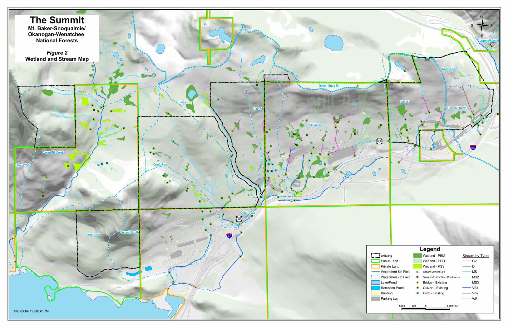
Hyak
Ski Acres
Lower Mill Creek
Upper Mill Creek
TunnelBeaver
Summit South
Creek Run
Other - Yak
Northside
Summit North
Other - Yak
Other - Snoq R.
Other - Yak
Upper Alpental
The SummitMt. Baker-Snoqualmie/Okanogan-Wenatchee
National Forests
Figure 2Wetland and Stream Map
NS
W
E
1,000 0 1,000500 Feet
LegendexistingPublic LandPrivate LandWatershed 5th FieldWatershed 7th FieldLake/PondRetention PondBuildingParking Lot
Wetland - PEMWetland - PFOWetland - PSSStream Monitor SiteStream Monitor Site - ContinuousBridge - ExistingCulvert - ExistingFord - Existing
Stream by TypeCVDMS1MS2MS3VB1VB2WB
5/25/2004 12:56:32 PM

Other - Snoq R.
Nacrinomical
International
Upper Alpental
Other - Snoq R.
W
E
NSAlpentalMt. Baker-Snoqualmie/Okanogan-Wenatchee
National Forests
Figure 3Wetland and Stream Map
1,000 0 1,000500 Feet
LegendexistingPublic LandPrivate LandWatershed 7th FieldBuildingParking Lot
Wetland - PEMWetland - PFOWetland - PSSStream Monitor SiteStream Monitor Site - ContinuousBridge - ExistingCulvert - ExistingFord - Existing
Stream by TypeCVDMS1MS2MS3VB1VB2WB
5/25/2004 12:57:15 PM

Appendix B: Wetland Technical Report
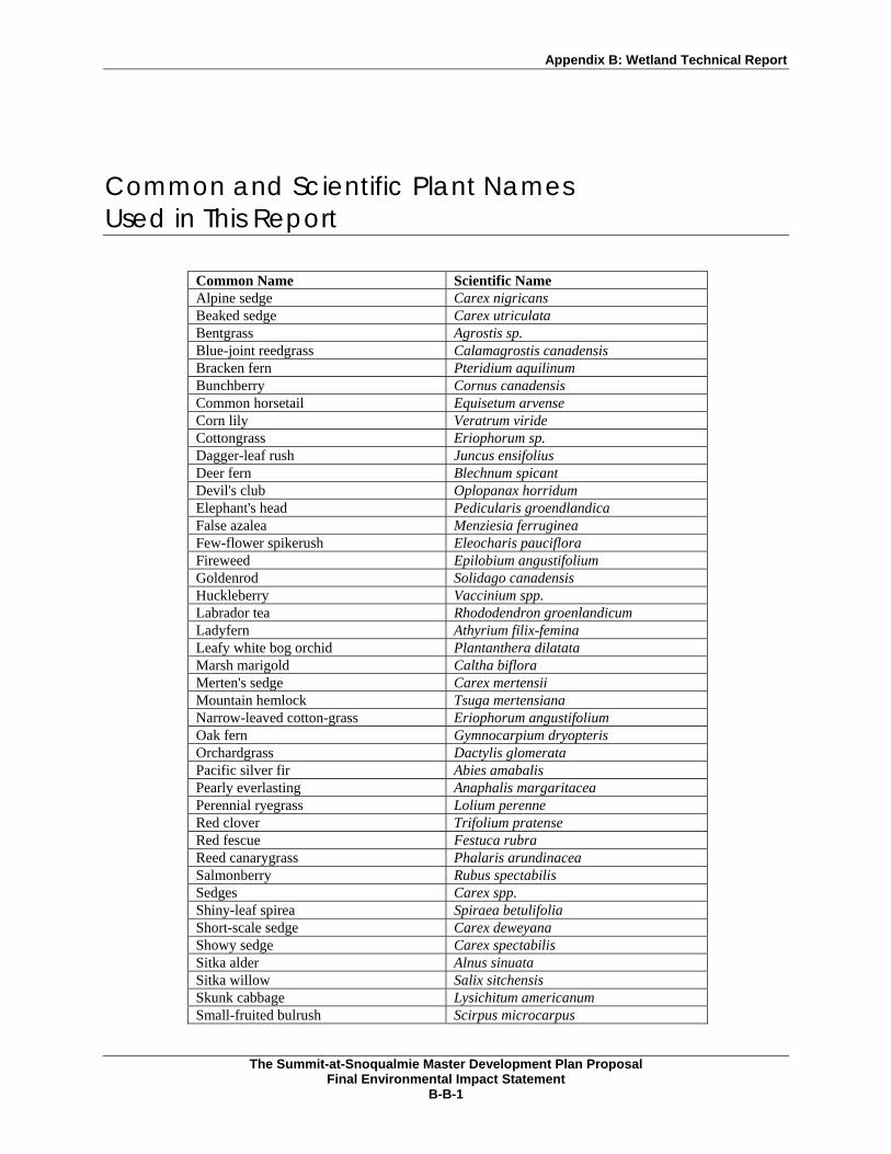
Appendix B Common and Scientific Plant Names Used in This Report
Appendix B: Wetland Technical Report
The Summit-at-Snoqualmie Master Development Plan Proposal
Final Environmental Impact Statement B-B-1
Common and Scientific Plant Names Used in This Report
Common Name Scientific Name Alpine sedge Carex nigricans Beaked sedge Carex utriculata Bentgrass Agrostis sp. Blue-joint reedgrass Calamagrostis canadensis Bracken fern Pteridium aquilinum Bunchberry Cornus canadensis Common horsetail Equisetum arvense Corn lily Veratrum viride Cottongrass Eriophorum sp. Dagger-leaf rush Juncus ensifolius Deer fern Blechnum spicant Devil's club Oplopanax horridum Elephant's head Pedicularis groendlandica False azalea Menziesia ferruginea Few-flower spikerush Eleocharis pauciflora Fireweed Epilobium angustifolium Goldenrod Solidago canadensis Huckleberry Vaccinium spp. Labrador tea Rhododendron groenlandicum Ladyfern Athyrium filix-femina Leafy white bog orchid Plantanthera dilatata Marsh marigold Caltha biflora Merten's sedge Carex mertensii Mountain hemlock Tsuga mertensiana Narrow-leaved cotton-grass Eriophorum angustifolium Oak fern Gymnocarpium dryopteris Orchardgrass Dactylis glomerata Pacific silver fir Abies amabalis Pearly everlasting Anaphalis margaritacea Perennial ryegrass Lolium perenne Red clover Trifolium pratense Red fescue Festuca rubra Reed canarygrass Phalaris arundinacea Salmonberry Rubus spectabilis Sedges Carex spp. Shiny-leaf spirea Spiraea betulifolia Short-scale sedge Carex deweyana Showy sedge Carex spectabilis Sitka alder Alnus sinuata Sitka willow Salix sitchensis Skunk cabbage Lysichitum americanum Small-fruited bulrush Scirpus microcarpus

Appendix B: Wetland Technical Report
The Summit-at-Snoqualmie Master Development Plan Proposal
Final Environmental Impact Statement B-B-2
Common Name Scientific Name Soft rush Juncus effusus Sphagnum moss Sphagnum sp. Spiraea Spiraea sp. Sticky tofieldia Tofieldia glutinosa Stink currant Ribes bracteosum Subalpine spirea Spiraea densiflora Swamp gentian Gentiana douglasiana Vine maple Acer circinatum Water sedge Carex aquatilis Western hemlock Tsuga heterophylla Western red cedar Thuja plicata