appendix c pine ridge community wildfi re protection plan c.pdf · wildland fire and fuel ......
TRANSCRIPT

APPENDIX CPine Ridge Community Wildfi re Protection Plan

1
Pine Ridge Fire Planning Area #1
Wildland Fire and Fuel Management Plan
Land Stewardship Associates LLC
Table of Contents Contents Page INTRODUCTION 1 Mission Statement 2 Goals 3 Objectives 3 FIRE HAZARD AND RISK ASSESSMENT 4 Description of Planning Area 4 Fire History 6 Workload and Resources Available 10 Fuel and Fire Hazards 11 Wildland Urban and Home Interface 13 Issues 41 PLAN FOR WILDFIRE AND FUEL HAZARDS 42 Site Specific Wildland Fire Responses & GPS Coordinates 43 Wildland Urban and Home Site Interface Mitigation Strategies 56 Interagency Cooperation and Coordination 59 Fuel Treatment Priorities 60 APPENDICES A: Vegetation Communities and Fire Effects B: Primary Fuel and Expected Fire Behavior C: Fuel Hazard Reduction Guidelines D: Defensible Space Guidelines E: Home Ignition Zone F: Definition of Terms G: Individual Triage Assessments

2
I. INTRODUCTION As with most of the West, the landscapes and vegetative patterns within the Pine Ridge area have been influenced more by fire than any other force. For thousands of years lightning fires occurred every summer creating a diverse mosaic of grass, shrub and forestland ecosystems that are present in different age classes. However, during recent decades, the influence of fire has diminished because of effective wildfire control, limited use of prescribed fire and reduced levels of timber management and harvest. Consequently the vegetation or fuel has become more homogeneous and “filled in”, which in turn has created a continuous vegetative cover that can carry wildfire for thousands of acres. When a wildfire occurs it can spread for miles and be difficult and expensive to control. These large wildfires can be damaging to ecosystems and watersheds and can perpetuate the establishment of vast acreages of the same vegetative type and age class. The vegetative type in the Pine Ridge area is grass/forest mix dominated by ponderosa pine (often called Yellow Pine). Open grassland (parkland) areas are frequently found throughout the forested area. The ponderosa pine forestlands like all other ecosystems are in a state of flux, constantly changing to adapt to the forces of nature and, to some degree, the influences of man. Growing in association with grasslands and various kinds of shrubs, the tree-dominated forest lands appear to be increasing in density and expanding their range—probably the result of 90 years fire suppression. A general description of vegetation found in the Pine Ridge area and how the common vegetation types respond to fire is presented in Appendices. The purpose of this plan is to effectively manage fire and hazardous fuels within the forested Pine Ridge Fire Planning Area #1 toward a common vision shared by the Chadron and Crawford Volunteer Fire Departments (VFDs), the counties, the state and federal agencies as well as the property owners. The plan reflects the preferences expressed through discussions with County, State and Federal agencies and includes an assessment of conditions relevant to wildfire in the urban interface and recommendations that are compatible with the wildfire planning completed by federal and state land managing agencies. Collaboration and implementation according the character of the landscape rather than by individual efforts is encouraged.
Finally, the plan will provide the Chadron and Crawford VFDs and their cooperators the information and guidance necessary to assist in the suppression of wildfire and the management of fuel hazards on privately owned lands. It will also provide some recommendations for cooperating state and federal agencies involved with cooperative management of wildfires. The safety of the public and firefighter personnel and equipment will remain the primary consideration in determining structure defensibility as well as the appropriate fire suppression response.

3
This plan is consistent with the Nebraska National Forest fire management plan. This Forest Service document is tiered to the Federal Wildland Fire Management Policy and Program Review (December 1995) and the Wildland and Prescribed Fire Management Plan (August 1998). All fire management decisions conform to the guidelines outlined in these documents. Fire management activities comply with the policies identified in state regulations on wilderness, threatened and endangered species, and culture/historical preservation as well as federal and state regulations for air and water quality. Obviously, there will be environment impacts that are both positive and negative. Potential impacts will be considered and negative impacts will be mitigated, as much as is practical, during implementation of this plan. Generally, the Forest Service suppression response policy is to aggressively suppress all wildfires within the Pine Ridge area. This includes the use of natural barriers and burning out when appropriate. Where appropriate, the use of prescribed fire and other fuel hazard treatment techniques are encouraged. In areas where private and public lands are intermixed such as they are in Chadron Creek the Forest Service policy is to promptly treat logging and thinning slash to reduce potential burning intensity. Also it is policy to design projects for fire hazard reduction, or thinning or logging so that direct attack is possible in the event of a wildfire. Fuel treatments are prioritized on National Forest land where there are high adjoining land values and where there is interest from adjoining landowners to cooperate toward reducing fire hazards along mutual boundaries.
Instrumental in the development of this fire plan was guidance from the Chadron and Crawford VFDs and input from the Nebraska National Forest, Nebraska State Forest Service (NSFS), Nebraska Game and Parks Commission (Parks and Wildlife Divisions), Pine Ridge Mutual Aid Association, Dawes County Sheriff, and local county planning officials. This fire plan strives toward consistency across boundaries with all government agencies as well as private property owners. Mission Statement The fire and fuels program initiated by Chadron and Crawford Volunteer Fire Departments for the Pine Ridge Fire Planning Area #1 seeks to provide a common vision for achieving resource benefits and providing protection of property while reducing hazardous fuels in a manner consistent with firefighter and public safety. Restoration of historic resource conditions present under a natural fire regime would be sought through harvest of forest products, prescribed fire, and breaks in fuel continuity.

4
Goals 1. Protect private property investments, developments and values. 2. Protect ecological values, including vegetation, water quality and yield, wildlife, and air resources and social values including public safety, and historic values. 3. Reduce wildland fire hazards and restore the functions of the ecological communities. 4. Reduce risk from wildfire ignitions.
Objectives Chadron and Crawford Volunteer Fire Departments will focus on six objectives for Pine Ridge Fire Planning Area #1 that will achieve the four general program goals discussed above: 1. Effectively and safely protect rural structures and properties from wildland fire
damage. 2. Identify high value areas such as urban interface and vulnerable resources that need
prescribed protection from wildfire. 3. Coordinate the planning and implementation of fuel treatments between land
jurisdictions to enhance consistency, to reduce fire hazard and to restore ecological values.
4. Monitor, evaluate and manage the effects of fire management actions. 5. Provide current and accurate information regarding proposed wildfire and fuels
management activities to the public and the cooperating agencies. 6. Improve cooperation with other agencies to provide interpretive and educational
programs designed to enhance public understanding and awareness of wildfire danger and safety as well as fire ecology and wildland fire management.

5
II. FIRE HAZARD AND RISK ASSESSMENT
Description of Planning Area The topography of the area is dominated by the Pine Ridge, an escarpment of sandstone bluffs that extends just beyond the border of Wyoming, through northwestern Nebraska, then into southwestern South Dakota. The Pine Ridge is characterized by extensive growth of ponderosa pine, with some small inclusions of quaking aspen. Within the Pine Ridge Fire Planning Area #1the elevations range between about 3,440 feet above sea level at Bordeaux Creek to 4,600 feet above sea level in the upper Squaw Creek area. Drainages flow mainly toward the north into the White River and from, west to east, include Squaw Creek, West Ash Creek, East Ash Creek, Cunningham Creek, Indian Creek, Trunk Butte Creek, Dead Horse Creek, Chadron Creek and Bordeaux Creek. The vegetative type in the Pine Ridge Fire Planning Area #1 is grass/forest mix dominated by ponderosa pine. Areas of open coniferous forest/grassland (savannah) also makeup this geographic area. Open grassland (parkland) areas are frequently found throughout the forested area. Principle deciduous tree species are cottonwood, hackberry, box elder, and green ash. Other woody species that can be found locally abundant are snowberry, chokecherry, and wild plum. Most of the deciduous trees and shrubs are found in stringers and patches along the drainages and near the cooler more humid environments. In general, fuel continuity in the ponderosa pine/grassland areas is high.
The Pine Ridge area is a mix of ponderosa pine, grassland openings with some stringers of hardwood vegetation along some of the bottomlands. Note the fuel continuity within the ponderosa pine.

6
Chadron, the county seat, is located just north of Pine Ridge Fire Planning Area #1 where US Highways 385 and 20 intersect. Chadron has a population of approximately 6,000 people. The town of Crawford, population 1100 is a short distance northwest of the planning area. The planning area covers approximately 106,400 acres and is divided between the Chadron VFD area and the Crawford VFD area. About 30 percent is within the Crawford VFD area with about 70 percent in the Chadron VFD area. About 36 percent, or 38,230 acres, of the planning area is comprised of public land. The fire planning area has a population of over 600 people with a little less than half the population residing on small ranches and farms. About 60 percent of the people do not live on their forested property but they use their house or cabin or mobile home intermittently during vacation, weekends or seasonally. Major travel routes that lead into and out of the county intersect with one another in Chadron and Crawford.
Small home site development along US Highway 385

7
Fire History Historically, small and medium sized fires occurred in the Pine Ridge country fairly frequently. Occasionally, the fires would burn large areas sometimes starting in the grassland type and moving into the timber type. At other times the fire would be ignited in the timber type during a mid-summer lightning storm and burn around the Pine Ridge country landscape for most of the summer. Sometimes these fires would burn hot and kill an entire stand and at other times it would creep along the ground not creating a lot of heat intensity. The result was usually a mosaic of age and size classes along with patterns of aspen, which, in some places, tends to proliferate within new forest openings. Studies show that prior to 1900 surface fire occurred every 5 to 15 years but the reoccurrence was highly variable. Since the early 1900s with man’s suppression efforts, fires on the same surface have occurred on an average of every 40 to 50 years. Prior to 1900 the forested areas were probably much more open, still dominated by ponderosa pine. Mature ponderosa pine trees have thick bark and a high tolerance of surface fire. Some of the creeks may have carried stronger and longer lasting flows of water into the early fall. The open grassland areas existing in this planning area, in the past, were larger and more connected. Because of the higher tree density in the present environment, many of the wildfires in the ponderosa pine type today burn into the forest canopy (crown fires). Because tree density since 1900 has probably increased, evapotranspiration (evaporation from leaf surfaces of moisture transpired there from the soil through the plants roots and vascular system) has probably increased thereby reducing stream flow from historic conditions where some of the creeks may have carried stronger and longer lasting flows of water into the early fall.
Pine Ridge landscape in 1912 (above). Surface fire return frequency was 5-15 yrs.

8
Pine Ridge landscape in 1999 (below). Fire has been limited from the ecosystem.
There are basically two kinds of fire. One is the destructive kind that burns with high intensity and with high mortality to the vegetation. It usually starts as a ground level fire and burns up into the tree crowns and, due to high heat intensity, causes damage to soil and watershed conditions, wildlife habitats, and sometimes homes and other facilities that people use. Because of the intense heat that results, trees not killed directly by this kind of fire are often weakened and become vulnerable for insect and disease epidemics. Usually we go all out to control this kind of fire. The other kind of fire burns with less intensity, at the right time, and under the right conditions and serves as a catalyst for forest renewal. Most of the forest vegetation survives this kind of fire. Forest floor debris is consumed and as a result nitrogen, phosphorus, potassium and other nutrients are released into the soils stimulating fresh healthy vegetative growth. Small thickets are thinned or removed thus reducing inter-forest competition that often times stifles growth and diminishes forest health. Prescribe Fire

9
Branches close to the ground are pruned from the larger trees allowing more sunlight to reach the forest floor benefiting ground level vegetation. Often times old decadent brush species are revitalized by fire. They will sprout new growth close to the ground that is valuable for wintering wildlife. Even under these conditions the fire may occasionally burn into the crowns in spots killing trees. Later these openings add to the mosaic effect of a more open forest environment. Man uses prescribed fire to achieve these results. Annual wildland wildfire occurrence in the Pine Ridge Fire Planning Area #1 is generally low to moderate. According to the Forest Service and County records, there is an average of 20 to 25 wildfires per year. Lightning is the primary source of ignition for most wildfires although human activities are responsible for a few of the wildfire ignitions. During most years the majority of the fires are small and do not burn with high intensity because of rain and or quick suppression. However, every few year’s medium sized and large fires occur and burn with high intensity.
Fire burning in August 2002 approximately 750 acres. Wind is from the NW. At least once or twice every five years fire danger and fire behavior is very high and extreme. During these conditions, every one to five years, the Pine Ridge area has experienced two or more fires that are 500 to over 1000 acres and that are high intensity fires posing a threat to rural home areas and damage to major watersheds. Often the fires are wind driven from the SW or NW and they will burn across drainages at a rapid rate. This situation challenges fire suppression personnel and agency managers to remain vigilant monitoring the fire danger

10
ratings and indices, particularly the heavy fuel moisture (1000 hour time lag fuels), during the fire season. The medium or large size wildfires, which have burned with high intensity, do not readily regenerate for years afterward even with artificial reforestation efforts. The East Ash Creek Fire of 1976 and the Dead Horse Fire of 1973 are examples.
Dead Horse fire occurred in 1973 and has resisted at least three reforestation efforts. Fuel continuity throughout the forested areas of this planning area and in some of the open grassland parks is very high to extreme. These areas also have a high rate of spread and in the timber a high resistance to control during very high and extreme fire danger. The Chadron and Crawford VFDs have an agreement for “Cooperative Fire Protection” with other agencies that have land management and wildfire control responsibilities in the county. Also, annually a “Fire Operating Plan” is updated and agreed to by the same agencies. Both the agreement and annual operating plans prescribe mutual aid and coordination throughout the counties. Most of the fires that occur are creeping or surface fires and are usually attacked directly keeping their size to something around 1-50 acres. For fires of 50 acres or larger the most common type of attack is “indirect” where firefighters utilize existing fuel breaks to control the fires. The fire’s ultimate control, shape and size is influenced most by connecting existing barriers in the area such as roads, sandy washes, rock outcrops, and other fuel breaks.

11
Workload and Resources Available Chadron and Crawford VFD units along with the county, federal and state agencies have a moderate to high wildland fire load when compared with other areas. Between the two volunteer fire departments there are approximately 75 volunteer firefighters. The following equipment is available for wildland wildfire suppression: Chadron VFD Four Type 6 Engines - three carry 250 gallons and one carries 180 gallons Three Type 2 Engines – one carries 750 gallons and two carry 1200 gallons Two portable 2500 gallons tanks with two portable pumps One command vehicle One rescue vehicle Two ambulances One 5000 gallon water tender (owned by the county road department) Crawford VFD Two Type 7 Engines – one carries 110 gallons and one carries 275 gallons Three Type 6 Engines - all three carry 250 gallons Three Type 2 Engines – one carries 500 gallons and two carry 1200 gallons One Type 1 Engine – carries 1000 gallons One command vehicle One equipment vehicle Two ambulances One 6000 gallon water tender (owned by the county road department) Forest Service (FS) is the primary responders on public lands to wildland wildfire occurrences although the volunteer’s of Chadron and Crawford VFDs are often the first to respond to a fire during initial attack. Chadron and Crawford VFDs volunteers are the primary responders to all structure fires and to wildland fires that occur on privately owned lands. Cooperative Fire Protection agreements describing “mutual aid” provide a formal structure that encourages a cooperative approach between the volunteer fire departments and the state and federal agencies. The FS maintains an integrated fire management and suppression staff that has interagency responsibility for fire control in the area. Resources maintained by FS include one Type 6 Engine and one Type 7 Engine along with approximately 15 people with hand tools for initial attack. In addition the FS has a contract Heavy Air Tanker available from Rapid City and a Helicopter with a 5-6 person Helitack Crew available locally after July 1 for initial attack. Also, there are 35 or more firefighters with ground tools available with two hours notice for extended initial attack or for reinforcements.

12
Fuel and Fire Hazards The primary fuels within the county are grassland and forested land. Fuel Models 2 and 10 probably best depict the ponderosa pine type as well as the other mixed timber fuel types depending on the amount of dead and down material intermingled, the canopy closure and age (size) class of the timber. Fuel Models 8 and 9 depict some of the deciduous stands in the summer and is indicative of fall burning conditions in these types. Fuel Model 1 is the best depiction of grasslands. Fuel Model 2 is the best indicator of fire behavior when the dry grass along with needles and dead and down stem wood is expected to carry the fire. The appendices includes a display of the expected fire behavior for each of the above Fuel Models under the conditions actually experienced on an average worst day with respect to fire weather.
Ponderosa pine vegetative type, which exemplifies Fuel Model 10 The primary concerns within the planning area where most of the private structures are located are with the ponderosa pine fuel continuity and the grassland fuel rate of spread. A very high to extreme fuel hazard exists where ponderosa pine has a dense canopy with ladder fuels below and /or debris underneath due to past insect mortality, blow-down or thinning operations. The ponderosa has a high resistance to control when the burning conditions are severe. When there are structures within or adjacent to a ponderosa pine wildfire during very high or extreme burning conditions the structures and all the area around the structures are going to be exposed to a “storm” of fire brands that can threaten the survival of buildings if there is any debris, pine needles, grass, duff, or combustible fuel in contact with the structure.

13
The ponderosa pine/grassland mix can be very volatile with a high rate of spread (see Appendices). Where grassland is intermingled with or adjacent to dense ponderosa pine a severe fire hazard exists. As a rule, whenever the flame lengths are over 4 feet the fire can easily move from the surface fuels to the crowns. When the relative humidity (RH) in pine fuels is 20% or lower the ignition of new spot fires will be prolific. Therefore, the most common recommendations and proposals are focused on breaking fuel continuity in areas where values and investments are high and where public safety and firefighter safety are sometimes in jeopardy.
Ponderosa pine is aggressively reproducing in many of the openings creating more “fill in” of fuel continuity as well as vertical fire ladders of flammable forest fuels across the Pine Ridge landscapes.

14
Wildland Urban and Home Site Interface In this planning area the wildland urban interface is comprised of six rural structural home developments and the wildland home site interface is comprised of over two hundred independent small ranch and/or rural homes that usually include an assortment of utility buildings within or near the forested areas. Some of the home developments are located in areas where wildland fire hazard is low. However, each is assessed. Some of the home developments are subdivisions where structure density is high while others are comprised of a few structures scattered over a large area. There are a total of over 870 buildings with a potential to construct or reconstruct another 200-400 buildings within the so-called wildland-urban interface. The following is a site-specific fire hazard assessment for each wildland structure group or urban interface. The assessment considers natural fuels as well as the condition of the buildings and facilities including the construction materials, defensible space and access. Information from these rating sheets was used as a guide for the assessments and the rating of each area. The natural fuel types are delineated according to the Fuel Model they represent so that the fire behavior on a severe day can be visualized. See Appendices for these fire behavior predictions. Site-specific mitigation recommendations are included. Based on the onsite assessment of factors that influence a rural development area or subdivision’s vulnerability we recommend that the Chadron and Crawford VFDs ask their respective county governments to consider the following general recommendations regarding defensible space. Defensible space is a key word in all the “FireWise” guidelines and standards (see Appendices). It usually refers to the fuel hazard conditions in the area immediately around a structure. The intention is to develop enough defensible space to enable fire suppression crews to “defend” the structure in the event of a wildfire. Defensible space should also be thought of as space where firefighters can “safely” defend the structure. Please see Chadron and Crawford VFD Triage that should be used by firefighters doing suppression adjacent to a structure. The county governments and the Chadron and Crawford VFDs should work together to acquire information that is critical for response to emergency calls. Part of this could include seeking cooperation from the developers and property owners who intend to construct roads, driveways, and dwellings. The following information or safeguards should be provided, as appropriate:
• Community fuel treatment standards with regard to the areas between building sites.
• Information to every lot and homebuyer with regard to “FireWise” building standards and defensible space.
• At least two access routes for ingress and egress to the subdivision. • A certain road construction and maintenance standard that accommodates fire
suppression equipment.

15
• Designated safety zones that are maintained in case of wildfire. • GPS locations for new building sites. • Designation of locations or facilities specific for fire suppression water needs.
In most forested areas during high and extreme fire danger, Chadron and Crawford VFDs may not be able to safely respond to emergency calls or effectively defend property and structures within the forested areas if this information is not available. Following is a brief assessment with recommendations for each home site structural development area and community within the planning area:

16
Squaw Creek SC 1-17 (24 sites or separate groups of buildings) General Description The Squaw Creek drainage encompasses an area that is about 7 miles from north to south and about 6 miles from east to west. The area is in a wildfire hazard environment and is composed of a series of homes, cabins and vacant or historic structures off Squaw Creek Road, Table Road and the western portion of West Ash Creek Road. It is located south of US Highway 20 about 4 miles southeast of Crawford, NB. The area includes 24 home sites or groups of homes on privately owned land that are not structured as subdivisions. Structures include occupied homes with out buildings (barns, garages and etc), cabins that are occupied seasonally and vacant or historic structures that not maintained and may be ruins. All the sites are outside the national forest boundary. The area includes the Ponderosa Wildlife Management Area managed by the Nebraska Department of Game and Parks and the Crow Butte Project owned and operated by Crow Butte Resources. The Crow Butte Project includes more than 40 metal buildings and several thousand wells that pump and re-inject water from a formation bearing uranium. Access to the site is sensitive and visitors are expected to register at the main office. Natural Fire Hazards Fuels Heavy fuels in the area are predominately pure stands of ponderosa pine on the sides of ridges and on north slopes of the escarpment and canyons. Hardwood species including cottonwood, ash, box elder, plum and choke cherry that dominate the drainage bottoms develop considerable fuel in the form of dead branches and dry leaves. Anticipated fire behavior in these types would be similar to Fuel Model 9 or 10. In the most northerly and southerly portions open, rolling, open grasslands with stringers of ponderosa pine and hardwoods with a grass under story vegetation are prominent. Fire behavior in these areas would be classified as Fuel Model 1 for open grassland or Fuel Model 2 when the dry grass along with needles and dead and down stem wood is expected to carry the fire. In the northern portion of the area some logging has been used to harvest ponderosa pine and to create a more open stand. Slash and tops have been piled in openings but most have not been burned. Slope Most of the homes in the area use Squaw Creek Road as their primary access. It is surfaced and is well maintained. The road maintains a slope of less than 5 percent while individual driveways may have short stretches that steeper. Driveways are usually not surfaced and vary considerably in slope and quality.

17
Home Site Development and Maintenance The area and home site developments generally are low to moderate in their vulnerability to a wildfire. Most homes have composition or metal roofs with composition or wood siding. Some of the older structures had wooden roofs and weathered wood siding that would be highly vulnerable in a wildfire situation. Utilities were generally above ground except for the most recently constructed homes. Several propane tanks were located close to a structure or down slope from a structure. Some “FireWise” practices are being practiced but much more effort is needed. While road signs were usually present there was no consistent system of identifying home addresses and only a portion of the homes had numbers posted so they could be read from the road. Water for fire suppression is available from Dodge reservoir one mile west of Squaw Creek Road in Section 12. Another source of water exists from the Crow Butte Project’s water station (Mayfield Place) on the north side or Section 13. Squaw Creek also has water but residents anticipate reduced flows or no flow during the dry summer. Windmills are located throughout the area but are not a reliable source of water in the quantities that would be needed for fire suppression. Risk Risk is on the low side of moderate for most homes. Most structures have been constructed either in an open area or on the edge of clearings or naturally open grassland with woodland or forest as a backdrop. The forest canopy is usually discontinuous with large openings interspersed throughout. However the risk increases significantly for structures located in close proximity to dense stands of ponderosa pine where a crown fire would be difficult to control. Some homeowners exacerbate the risk by stacking firewood near their home. Vulnerability Generally the home site development area’s vulnerability is in the low to moderate range. No evacuation plans are known to exist but large grassy areas provide safety areas for the firefighter as well as the residents and Squaw Creek Road provides easy access to exit the area either up the drainage or down. A bridge is out on the access road to SC3, which also results in no access to a large area between Squaw Creek and West Ash Creek. Recommendations 1. Support the continuance of “FireWise” education and awareness. 2. Property owners should expand their defensible space and do fuel hazard reduction including thinning within 150 to 200 feet of their buildings. 3. Access driveways should be improved and graveled and provided with terminus turn around that has at least a 45-foot radius. 4. Roads and driveways should be marked and addressed for more efficient emergency access. 5. Prescribed burning and logging should be encouraged to create an open stand of ponderosa and fuel compartments especially along the road and where natural open areas can be linked together. 6. The access road to SC3 needs to have the bridge repaired or a large culvert installed.

18
A bridge is out on the access road to SC3 which also results in no access to a large area between Squaw Creek and West Ash Creek.SC 1A.
Example of great driveway access.

19
Saw Log Fire damage occurring in 2000 in west side of Squaw Creek
SC 6 Very good defensible space

20
West Ash Creek WA 1-19 (21 sites or separate groups of buildings) General Description The Squaw Creek drainage encompasses an area that is about 7 miles from north to south and about 5 miles from east to west. The area is in a wildfire hazard environment and is composed of a series of homes, cabins and vacant or historic structures off West Ash Creek Road, Table Road and Bethel Road. It is located south of US Highway 20 about 7 miles southeast of Crawford, NB. The area includes 22 home sites or groups of homes on privately owned land that are not structured as subdivisions. Structures include occupied homes with out buildings (barns, garages and etc), cabins that are occupied seasonally and vacant or historic structures that not maintained and may be ruins. Most of the sites are outside the national forest boundary. Natural Fire Hazards Fuels Heavy fuels in the area are predominately pure stands of ponderosa pine on the sides of ridges and on north slopes of the escarpment and canyons. Hardwood species including cottonwood, ash, box elder, plum and chokecherry that dominate the drainage bottoms develop considerable fuel in the form of dead branches and dry leaves. Anticipated fire behavior in these types would be similar to Fuel Model 9 or 10. In the most northerly and southerly portions open, rolling, open grasslands with stringers of ponderosa pine and hardwoods with a grass under story vegetation are prominent. Fire behavior in these areas would be classified as Fuel Model 1 for open grassland or Fuel Model 2 when the dry grass along with needles and dead and down stem wood is expected to carry the fire. In the northern portion of the area logging has been used to harvest ponderosa pine and to create a more open stand. Slash and tops have been piled in openings but most have not been burned. The resulting open stands of ponderosa pine are less vulnerable to a crown fine and forest health is improved Slope Most of the homes in the area use West Ash Creek Road as their primary access. It is not surfaced and the deep fine sand is subject to wind and water erosion. Road conditions following significant precipitation can be difficult as the roads in the area become soft. The road usually maintains a slope of less than 5 percent with short pitches that are 8 to 10 percent grade. as you travel up or down the drainage. Most driveways have some surfacing (gravel or rock) and those that are not surfaced are vulnerable to rutting in wet conditions. Home Site Development and Maintenance The area and home site developments generally are low to moderate in their vulnerability to a wildfire. Most homes had composition or metal roofs with composition or wood siding. Some of the older structures had wooden roofs and weathered siding that would be highly vulnerable in a wildfire situation. Utilities were generally above ground except for the most recently constructed homes. Several propane tanks were located too close to

21
structure or down slope from a structure. Some “FireWise” practices are being practiced but much more effort is needed. While road signs were usually present there was no consistent system of identifying home addresses and only a portion of the homes had numbers posted so they could be read from the road. Water for fire suppression is available from Dodge reservoir one mile west of Squaw Creek Road in Section 12. Another source of water exists from the Crow Butte Project’s water station (Mayfield Place) on the north side or Section 13. West Ash also has water, such as at WA 10, but residents anticipate reduced flows or no flow during the dry summer. Windmills are located throughout the area but are not a reliable source of water in the quantities that would be needed for fire suppression. Risk Risk is on the low side of moderate for most homes. Most structures have been constructed either in an open area or on the edge of clearings or naturally open grassland with woodland or forest as a backdrop. The forest canopy is usually discontinuous with large openings interspersed throughout. However the risk increases significantly for structures located in close proximity to dense stands of ponderosa pine where a crown fire would be difficult to control. Some homeowners exacerbate the risk by stacking firewood near their home. Vulnerability Generally the home site development area’s vulnerability is in the low to moderate range. No evacuation plans are known to exist but large grassy areas provide safety areas for the firefighter as well as the residents. West Ash Creek Road provides the only way out of the area and it can be difficult to travel when the ground is wet. The driveway to the structure described as WA10 is about 0.8 miles long, narrow and has numerous soft stream crossings that make it impractical to access with a fire engine. Water for fire suppression is available from ponds on the site. Recommendations 1. Support the continuance of “FireWise” education and awareness of the property
owners. 2. Property owners should expand their defensible space and do fuel hazard reduction including thinning within 150 to 200 feet of their buildings. 3. West Ash Creek Road should be surfaced with a road base aggregate to provide a hard surface and improve it as an all weather access through the area. 4. All access driveways should be improved, graveled and provided with terminus turn around that has at least a 45-foot turning radius. 5. Roads and driveways should be marked and addressed for more efficient emergency access. 6. Prescribed burning and logging should be encouraged to create an open stand of ponderosa and fuel compartments especially along the road and where natural open areas can be linked together.

22
Open ponderosa pine forest recently logged. Slash will be burned in the near future. This is near WA 9.

23
WA 10 Home site with water at the end of sandy difficult to travel road.
Forested area near WA 11A. Fuel Model 10
24
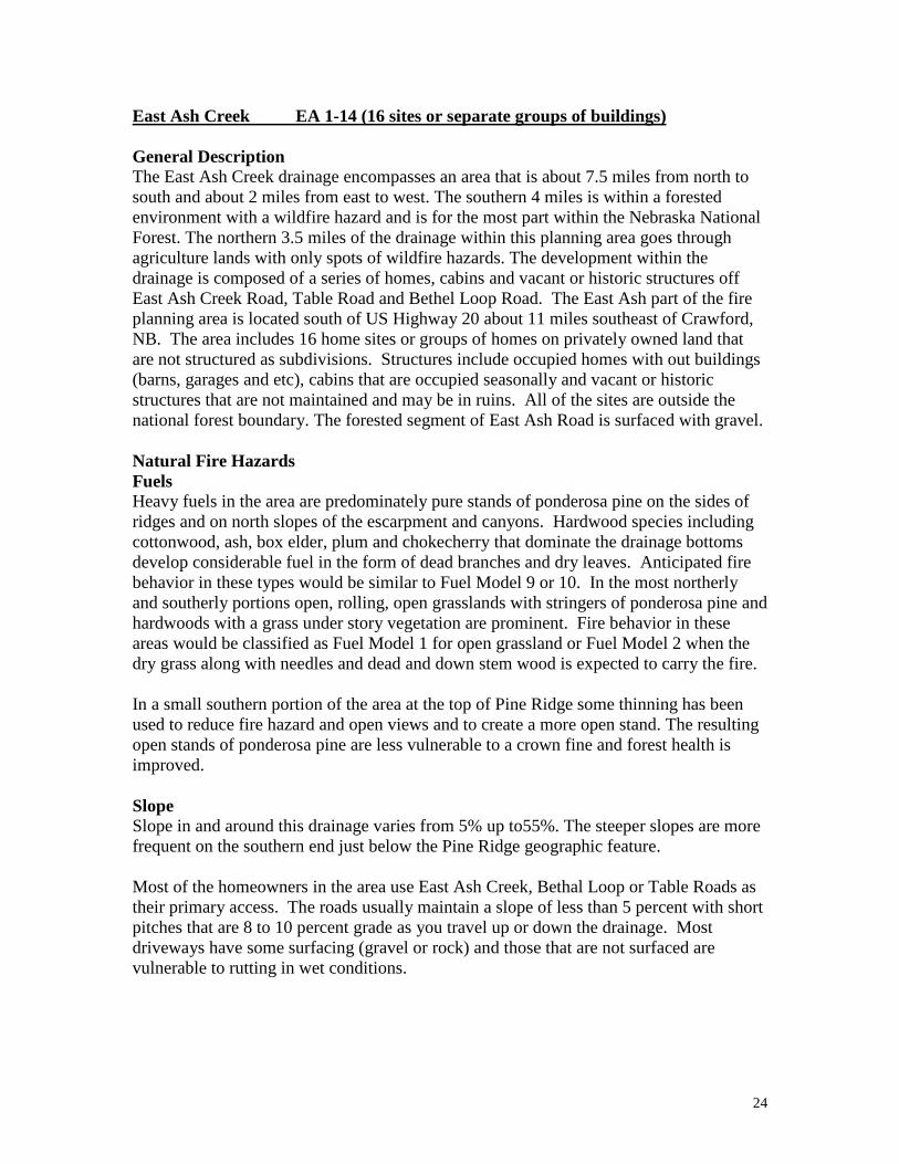
East Ash Creek EA 1-14 (16 sites or separate groups of buildings) General Description The East Ash Creek drainage encompasses an area that is about 7.5 miles from north to south and about 2 miles from east to west. The southern 4 miles is within a forested environment with a wildfire hazard and is for the most part within the Nebraska National Forest. The northern 3.5 miles of the drainage within this planning area goes through agriculture lands with only spots of wildfire hazards. The development within the drainage is composed of a series of homes, cabins and vacant or historic structures off East Ash Creek Road, Table Road and Bethel Loop Road. The East Ash part of the fire planning area is located south of US Highway 20 about 11 miles southeast of Crawford, NB. The area includes 16 home sites or groups of homes on privately owned land that are not structured as subdivisions. Structures include occupied homes with out buildings (barns, garages and etc), cabins that are occupied seasonally and vacant or historic structures that are not maintained and may be in ruins. All of the sites are outside the national forest boundary. The forested segment of East Ash Road is surfaced with gravel. Natural Fire Hazards Fuels Heavy fuels in the area are predominately pure stands of ponderosa pine on the sides of ridges and on north slopes of the escarpment and canyons. Hardwood species including cottonwood, ash, box elder, plum and chokecherry that dominate the drainage bottoms develop considerable fuel in the form of dead branches and dry leaves. Anticipated fire behavior in these types would be similar to Fuel Model 9 or 10. In the most northerly and southerly portions open, rolling, open grasslands with stringers of ponderosa pine and hardwoods with a grass under story vegetation are prominent. Fire behavior in these areas would be classified as Fuel Model 1 for open grassland or Fuel Model 2 when the dry grass along with needles and dead and down stem wood is expected to carry the fire. In a small southern portion of the area at the top of Pine Ridge some thinning has been used to reduce fire hazard and open views and to create a more open stand. The resulting open stands of ponderosa pine are less vulnerable to a crown fine and forest health is improved. Slope Slope in and around this drainage varies from 5% up to55%. The steeper slopes are more frequent on the southern end just below the Pine Ridge geographic feature. Most of the homeowners in the area use East Ash Creek, Bethal Loop or Table Roads as their primary access. The roads usually maintain a slope of less than 5 percent with short pitches that are 8 to 10 percent grade as you travel up or down the drainage. Most driveways have some surfacing (gravel or rock) and those that are not surfaced are vulnerable to rutting in wet conditions.

25
Home Site Development and Maintenance The area and home site developments generally are low to moderate in their vulnerability to a wildfire. Most homes have composition or metal roofs with composition or wood siding. Some of the older structures have wooden roofs and weathered siding that would be highly vulnerable in a wildfire situation. Utilities were generally above ground. Some “FireWise” practices are being practiced but much more effort is needed. While road signs were usually present there was no consistent system of identifying home addresses and only a portion of the homes had numbers posted so they could be read from the road. Water for fire suppression is available from Dodge Reservoir one mile west of Squaw Creek Road in Section 12. Another source of water exists from the Crow Butte Project’s water station (Mayfield Place) on the north side or Section 13. East Ash also has water but residents anticipate reduced flows or no flow during the dry summer. Windmills are located throughout the area but are not a reliable source of water in the quantities that would be needed for fire suppression. Risk Risk is on the low side of moderate for most homes. Most structures have been constructed either in an open area or on the edge of clearings or naturally open grassland with agriculture land, woodland or forest as a backdrop. The forest canopy is usually discontinuous with large openings interspersed throughout. However the risk increases significantly for structures located in close proximity to dense stands of ponderosa pine where a crown fire would be difficult to control. Vulnerability Generally the home site development area’s vulnerability is in the low to moderate range. No evacuation plans are known to exist but, with some burning out, large grassy areas provide safety areas for the firefighter as well as the residents. Within the National Forest East Ash Creek Road provides the only way out of the area. Water for fire suppression is available from ponds on the site. Recommendations 1. Support the continuance of “FireWise” education and awareness of the property
owners and introduce them to the cost share incentives offered by the Nebraska State Forest Service for individual as well as neighborhood “FireWise” practices.
2. Property owners should expand their defensible space and do fuel hazard reduction
including thinning within 150 to 200 feet of their buildings. 3. Access driveways should be improved and graveled and provided with terminus turn
around that has at least a 45-foot radius. 4. Driveways without turnaround or with steep slopes should be marked with a sign
indicating limitations.

26
5. Roads and driveways should be marked and addressed for more efficient emergency access.
6. Treat fuels along strategic roads specifically the forested part of East Ash Creek
Road. 7. Expand scale of fuel hazard treatments through interagency and property owner
coordination. 8. Develop a multi-year multi-unit prescribed burning program for the entire area.
Logging and fuel hazard reduction at the head of East Ash Creek
27
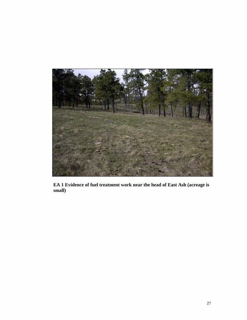
EA 1 Evidence of fuel treatment work near the head of East Ash (acreage is small)

28
Cunningham/Indian Creek CI 1-9 (10 sites or separate groups of buildings) General Description This area is in a wildland fire hazard environment and is composed of a few small home sites around the headwaters of Cunningham and Indian Creek drainages. This area is located approximately 19 miles southwest of Chadron, Nebraska. Some of the ten building sites in this drainage are unoccupied and most are in open grassland and/or agriculture land.
Natural Fire Hazards Fuels: In the most northerly and southerly portions open, rolling, grasslands with stringers of ponderosa pine and hardwoods and grass under story vegetation and/or agriculturally developed lands. Fire behavior in these areas would be classified as Fuel Model 1 when the dry grass is expected to carry the fire. The central part of this area is heavily forested but not roaded very well and it has no occupied building sites. Much of it is within the Nebraska National Forest. The Fuel Models for this area is 9 or 10 with some 2. Slope: Slopes vary from less than 5% up to 40%. Home Site Development and Maintenance The area includes ten home sites or groups of homes on privately owned land that are not structured as subdivisions. Structures include occupied homes with out buildings (barns, garages and etc), cabins that are occupied seasonally and vacant or historic structures that are not maintained and may be in ruins. Generally, some of the buildings are un-maintained and unoccupied while some are well kept but small and simple. Defensible space is fairly adequate. Fire equipment should have no trouble reaching most of the buildings and there would be no trouble turning around. Risk Risk is medium to very high due to the building site remoteness Vulnerability Generally, in the central and lower parts of the forested area the home site vulnerability is moderate to high depending on the grass fuels.
Recommendations 1. Support the continuance of “FireWise” education and awareness of the property
owners and introduce them to the cost share incentives offered by the Nebraska State Forest Service for individual as well as neighborhood “FireWise” practices.
2. Roads and driveways should be marked and addressed for more efficient emergency access.

29
Trunk Butte Creek TB 1-4 (5 sites or separate groups of buildings) General Description This area is in a wildland fire hazard environment and is composed of a few small home sites around the headwaters of Trunk Butte Creek drainage. This area is located approximately 17 miles southwest of Chadron, Nebraska. Most of the five building sites in this drainage are unoccupied and most are in open grassland and agriculture land.
Natural Fire Hazards Fuels: This area is predominantly open grassland and agriculturally developed lands with scattered pine and a few hardwoods. Fire behavior would be characterized as Fuel Model 1. Slope: Slopes vary from less than 5% up to 40%. Home Site Development and Maintenance The area includes five home sites or groups of homes on privately owned land that are not structured as subdivisions. Structures include occupied homes with out buildings (barns, garages and etc), cabins that are occupied seasonally and vacant or historic structures that are not maintained and may be in ruins. Generally, some of the buildings are un-maintained and unoccupied while some are well kept but small and simple. Defensible space is fairly adequate. Fire equipment should have no trouble reaching most of the buildings and there would be no trouble turning around. Risk Risk is medium to very high due to the building site remoteness Vulnerability Generally, in the central and lower parts of the forested area the home site vulnerability is moderate to high depending on the grass fuels.
Recommendations 1. Support the continuance of “FireWise” education and awareness of the property
owners and introduce them to the cost share incentives offered by the Nebraska State Forest Service for individual as well as neighborhood “FireWise” practices.
2. Roads and driveways should be marked and addressed for more efficient emergency
access.

30
Dead Horse Creek DH 1- 26 (27 sites or separate groups of buildings) General Description The Dead Horse Creek drainage encompasses an area that is about 7.5 miles from north
to south and about 4.5 miles from east to west. The southern 4 miles is within a forested environment with a wildfire hazard. The northern 3.5 miles of the drainage within this planning area goes through agriculture lands with only spots of wildfire hazards. The development within the drainage is composed of a series of homes, cabins and vacant or historic structures off Dead Horse Creek Road and Table Road. There are 27 home site structural units within this drainage. Many appear to be older second homes or vacation homes. This area is located approximately 14 miles southwest of Chadron, Nebraska. All of the sites are outside the national forest boundary.
Natural Fire Hazards Fuels Heavy fuels in the area are predominately pure stands of ponderosa pine on the sides of ridges and on north slopes of the escarpment and canyons. Hardwood species including cottonwood, ash, box elder, plum and chokecherry that dominate the drainage bottoms develop considerable fuel in the form of dead branches and dry leaves. Anticipated fire behavior in these types would be similar to Fuel Model 9 or 10. In the most northerly and southerly portions open, rolling, grasslands with stringers of ponderosa pine and hardwoods with a grass under story vegetation are prominent. Fire behavior in these areas would be classified as Fuel Model 1 for open grassland or Fuel Model 2 when the dry grass along with needles and dead and down stem wood is expected to carry the fire. In a small southern portion of the area at the top of Pine Ridge some thinning has been used to reduce fire hazard and open views and to create a more open stand. The resulting open stands of ponderosa pine are less vulnerable to a crown fine and forest health is improved. Generally, the natural fire hazards within Dead Horse Creek range from medium to very high. Slope Slope in and around this drainage varies from 5% up to55%. The steeper slopes are more frequent on the southern end just below the Pine Ridge geographic feature. The roads usually maintain a slope of less than 5 percent with short pitches that are 8 to 10 percent grade as you travel up or down the drainage. Most of the driveways range from 5% up to 15% and have some surfacing (gravel or rock) and those that are not surfaced are vulnerable to rutting in wet conditions. Home Site Development and Maintenance The home site areas generally include occupied homes with out buildings (barns, garages and etc), cabins that are occupied seasonally and vacant or historic structures that are not maintained and may be in ruins. The area and home site developments within the forested environments generally are medium to very high in their vulnerability to a wildfire. Most homes have composition or metal roofs with composition or wood siding. Some of the

31
older structures have wooden roofs and weathered siding that would be highly vulnerable in a wildfire situation. Utilities were generally above ground. Some “FireWise” practices are being practiced but much more effort is needed. While road signs were usually present there is no consistent system of identifying home addresses and only a portion of the homes had numbers posted so they could be read from the road. Home sites with long driveways into home sites have adequate turnarounds for fire equipment. However, some of the home sites near the road are short and do not have a good turnaround. Fire equipment should avoid using most of these driveways roads unless they can safely be backed in. There is a home site adjacent to the road approximately 2 miles north of the intersection with Table Road that appears to very vulnerable to wildfire and very difficult if not hazardous to defend. Firefighters should insure the site is evacuation and be very cautious with their suppression efforts. Water for fire suppression is available along the creek. This water may be limited during the late summer and only available at the pond sites. There is a substantial pond near home site number DH 12. Windmills are located throughout the area but are not a reliable source of water in the quantities that would be needed for fire suppression. Risk Risk is high and very high in the forested areas due to the fuel continuity coupled with the presence of a few home sites that are unattended and a couple that are extremely unkept with an abundance of flammable debris around the buildings. A crown fire would be difficult to control. Vulnerability Generally, in the central and lower parts of the forested area the home site vulnerability is high. No evacuation plans are known to exist but there are numerous openings and roadways that could provide safety areas for the firefighter as well as the residents. Where structures have been constructed either in an open area or on the edge of clearings or naturally open grassland with agriculture land, woodland or forest as a backdrop vulnerability is low. Recommendations 1. Support the continuance of “FireWise” education and awareness of the property
owners and introduce them to the cost share incentives offered by the Nebraska State Forest Service for individual as well as neighborhood “FireWise” practices.
2. Property owners should expand their defensible space and do fuel hazard reduction
including thinning within 150 to 200 feet of their buildings.
3. Access driveways should be improved and graveled and provided with terminus turn around that has at least a 45-foot radius.

32
4. Driveways without turnaround or with steep slopes should be marked with a sign
indicating limitations. 5. Roads and driveways should be marked and addressed for more efficient emergency
access. 6. Treat fuels along strategic roads specifically the forested segment of Dead Horse
Creek Road. 7. Expand scale of fuel hazard treatments through interagency and property owner
coordination. 8. Develop a multi-year multi-unit prescribed burning program for the forested part of
the area.
Non-defendable home site within Dead Horse CK.
Defendable home site within Dead Horse CK.

33
DH 12 Easily defendable home site. Water is available.
DH 8 Turnaround is very tight and requires backing. Defendable space not developed

34
Chadron Creek CC 1-80 (200 sites or separate groups of buildings) General Description
The Chadron Creek drainage encompasses an area that is about nine miles from north to south and about four miles from east to west. The area is in a wildfire hazard environment and is composed of several small home site developments including small subdivisions along both sides of US 385 along the Chadron Creek drainage. This area is located approximately 21 miles south of Chadron, Nebraska. The development in this area is composed of approximately 200 homes/facilities some that are new but many are older second homes or vacation homes. Most are located on private property but some are within Chadron State Park and are rented for short terms. This area includes subdivisions such as in Whispering Pines, Broken Plow, Parkview Terrace, and Pinedale Addition. Structures include occupied homes with out buildings (barns, garages and etc), cabins and modular homes that are occupied seasonally and vacant or historic structures that are not maintained and may be ruins.
Natural Fire Hazards Fuels Heavy fuels in the area are predominately pure stands of ponderosa pine intermingled with patches of open grassland on the sides of ridges and on north slopes of the tributary drainages. There are a few stringers of hardwood riparian including cottonwood, ash, box elder, plum and chokecherry. Along the drainage bottoms these species develop considerable fuel in the form of dead branches and dry leaves. Anticipated fire behavior in these forested types would be similar to Fuel Models 9 and 10. In the most northerly and southerly portions open, rolling, grasslands with stringers of ponderosa pine and hardwoods with a grass under story vegetation are prominent. Fire behavior in these areas would be classified as Fuel Model 1 for open grassland or Fuel Model 2 when the dry grass along with needles and dead and down stem wood is expected to carry the fire. Throughout the drainage there has been a lot of small fuel hazard reduction projects implemented and there are several more planned. Apparently Chadron State Park has accomplished the most hazard reduction work within one contiguous area. Generally, the natural fire hazards within Chadron Creek range from low to very high. Slope Slope in and around this drainage varies from 5% up to55%. The steeper slopes are more frequent on the southern end just below the Pine Ridge geographic feature. Most of the homeowners in the area use US Highway 385 as their primary access. It is paved and is well maintained. Slopes on the highway are less than 7%. while gravel roads and driveways in the subdivisions ranged from 5% up to 20%. Some roads are not surfaced and have ruts. Driveways are usually not surfaced and vary considerably in slope and quality. All of the main travel ways within Chadron State Park are paved or surfaces with gravel.

35
Home Site Development and Maintenance The home site development hazards range from low to very high. Generally, throughout the area there are home sites with inadequate defensible space intermingled with home sites with very good defensible space. Several homes are above steep forested slopes that increase their vulnerability. Some “FireWise” practices are being practiced but at a minimum level and much more effort is needed. Most homes have composition or metal roofs with composition or wood siding. Utilities were generally above ground except for the most recently constructed homes. Several propane tanks were located close to a structure or down slope from a structure. Most of the homes nearest US 385 or within a couple of subdivision circle drives have good defensible space. Several of the homes outside the circle and higher up on the terrain do not have adequate defensible space. Road signs are sometimes present but there was no consistent system of identifying home addresses and only a portion of the homes had numbers posted so they could be read from the road. Within the small subdivisions signage is almost non-existent, with only a few property numbers and street signs posted. Water source hydrants are available at the Job Corps, City Dam, and Country Club sites. Water is also available at a few other places along the creek and at the State Park. Roads into the home sites are generally dead-end with tight or inadequate turnarounds for fire equipment. Specifically, Camp Norwesca has a single lane driveway that connects the parking lot to the tent camping area. Fire equipment should avoid using this road due to its narrow width, no turnaround and an abundance of forest fuel adjacent to it. Risk Risk is on the low side of moderate for most homes. Most structures have been constructed either in an open area or on the edge of clearings or naturally open grassland with woodland or forest as a backdrop. The forest canopy is usually discontinuous with large openings interspersed throughout. However the risk increases significantly for structures located in close proximity to dense stands of ponderosa pine where a crown fire would be difficult to control. Vulnerability Generally the home site development area’s vulnerability is in the low to moderate range until the early fall. Throughout the area there are several homes that are very vulnerable due to their location within the forested area or at the top of a steep forested slope. No evacuation plans are known to exist but the corridor along US Highway 385 along with a few open areas provide safety areas for the firefighter as well as the residents. Water for fire suppression is available at the Job Corps, Chadron State Park, City Dam, and Country Club sites. Water is also available at a few other places along the creek and at the State Park. Recommendations 1. Support the continuance of “FireWise” education and awareness of the property
owners and introduce them to the cost share incentives offered by the Nebraska State Forest Service for individual as well as neighborhood “FireWise” practices.

36
2. Property owners should expand their defensible space and do fuel hazard reduction
including thinning within 150 to 200 feet of their buildings.
3. Access driveways should be improved and graveled and provided with terminus turn around that has at least a 45-foot radius.
4. Driveways without turnaround or with steep slopes should be marked with a sign indicating limitations.
5. Roads and driveways should be marked and addressed for more efficient emergency
access. 6. Improve emergency firefighter fire suppression access to the water from the large
water tank on top of the hill. 7. Treat fuels along strategic roads within the forested areas. 8. Mark safety zones and helispots. 9. Expand scale of fuel hazard treatments through interagency and property owner
coordination. 10. Develop a multi-year multi-unit prescribed burning program for the forested areas. 11. Each subdivision, Camp Norwesca, and Chadron State Park should develop
evacuation plans that accommodate initial attack vehicles while safely evacuating the residents.
Fuel hazard reduction within Chadron State Park.

37
CC 15 Steep timbered slope behind Job Corps.
CC 25 Good defensible space

38
CC 21A Home site in Broken Plow. Marginally defendable.
Fuel Model 9 within Chadron Creek

39
Bordeaux Creek BC 1-16 (17 sites or separate groups of buildings) General Description The Bordeaux Creek drainage encompasses an area that is about nine miles from north to south and about three miles from east to west. The area is in a wildfire hazard environment and is composed of home-sites along both sides of Table and Bordeaux Roads, which follow the southern and eastern ridgelines of the Bordeaux Creek drainage. This area is located approximately 21 miles southeast of Chadron, Nebraska. The total acreage of all the home site development areas together is approximately fifty acres. The drainage includes seventeen home sites on privately owned land. Structures include occupied homes with out buildings (barns, garages and etc), cabins and modular homes; trailer homes and several appear vacant. Natural Fire Hazards Fuels Heavy fuels in the area are predominately pure stands of ponderosa pine intermingled with patches of open grassland on the sides of ridges and on north slopes of the tributary drainages. There are a few stringers of hardwood riparian including cottonwood, ash, box elder, plum and chokecherry. Along the drainage bottoms these species develop considerable fuel in the form of dead branches and dry leaves. Anticipated fire behavior in these forested types would be similar to Fuel Models 9 and 10. In the most northerly and southerly portions open, rolling, grasslands with stringers of ponderosa pine and hardwoods with a grass under story vegetation are prominent. Fire behavior in these areas would be classified as Fuel Model 1 for open grassland or Fuel Model 2 when the dry grass along with needles and dead and down stem wood is expected to carry the fire. Several of the landowners along Table Road have done forest management (logging, thinning) in the pine stands north of their property. Several of the properties have old logging road access to the north facing slopes of pine stands. Slope Slope in and around this drainage varies from 5% up to 60%. The steeper slopes are more frequent in the drainage itself. Slopes around the home-sites vary from 5% to 20%. Access All of the homeowners in the area use Table and Bordeaux roads as their primary access, which is, maintained gravel surface with slopes from 0% to 10%. The exception to this is #718/Hallstead Road, which is rutted and has a section near the intersection with Table Road with slope in excess of 20%. Driveways, which usually are not surfaced, ranged from 0% up to 10%. Home Site Development and Maintenance The home site development hazards range from low to moderate. Generally, throughout the area home sites have defensible space. Several homes could use some trimming or removal of trees right next to the home or buildings. Most homes have composition or metal roofs with an occasional wood roof on older buildings, and composition or

40
wood siding. Utilities were generally above ground except for the most recently constructed homes. Several propane tanks were located close to a structure or down slope from a structure. “FireWise” practices should be reviewed and applied where appropriate. Road signs are lacking on Table Road. There was no consistent system of identifying home addresses and only a portion of the homes had numbers posted so they could be read from the road. Roads into the home sites are generally dead-end with several having tight or inadequate turnarounds for fire equipment. Several of the homes can be accessed directly from the road. Several of the home-sites had excessive accumulations of flammable debris, which should be removed. Risk Risk is on the low side of moderate for most homes. Most structures have been constructed either in an open area or on the edge of clearings or naturally open grassland with woodland or forest as a backdrop. The forest canopy is usually discontinuous with large openings interspersed throughout. However the risk increases significantly for structures located in close proximity to dense stands of ponderosa pine where a crown fire would be difficult to control. Several of the home-sites have dense stands of trees within one hundred feet of the buildings. Vulnerability Generally the home site development area’s vulnerability is in the low to moderate range. No evacuation plans are known to exist. Water for fire suppression is available at the Job Corps, City Dam, and Country Club sites. Recommendations 1. Support the continuance of “FireWise” education and awareness of the property
owners and introduce them to the cost share incentives offered by the Nebraska State Forest Service for individual as well as neighborhood “FireWise” practices.
2. Property owners should expand their defensible space and do fuel hazard reduction
including thinning within 150 to 200 feet of their buildings. 3. Where appropriate, access driveways should be improved and graveled and provided
with terminus turn around that has at least a 45-foot radius. 4. Roads and driveways should be marked and addressed for more efficient emergency
access. 5. Treat fuels along strategic roads within the forested areas.

41
6. Mark safety zones and helispots. 7. Expand scale of fuel hazard treatments through interagency and property owner
coordination. 8. Develop a multi-year multi-unit prescribed burning program for the forested areas.
Home sites within Bordeaux Creek

42
Pine Ridge Fire Planning Area #1 Issues The following is a list of most of the issues with regard to fire hazard, fire risks, and vulnerability. These guide the mitigation planning processes.
• Heavy fuel continuity between grass and ponderosa pine fuels across the forested area coupled with a history of wind-driven difficult to control wildfires;
• Firefighter safety;
• Many home sites without defensible space;
• Intermittent “FireWise” adherence within home site areas;
• A shortage of road terminus turnarounds;
• A few unmaintained narrow and/or steep roads;
• Fuel treatment work being accomplished on private lands but on a small scale;
• Only a small amount of fuel treatment coordination being done between
landowners;
• No evacuation plans where needed;
• No good subdivision maps;
• No system of addresses and street or road name signs;
• Many homeowners are intermittent residents;
• There is a fair amount of unoccupied or abandoned and possibly historic buildings within some areas.

43
III. PLAN FOR WILDFIRE AND FUEL HAZARDS Fire Management Response This plan is based on aggressive and full suppression of every wildfire. This plan helps coordinate and communicate the strategies and tactics to be used to accomplish the Pine Ridge Fire Planning Area #1 goals and objectives as well as the public land agencies goals and objectives. This plan defines the extent that fire, along with other fuel management techniques, will be used throughout the county. The Fire and Fuels Plan for Pine Ridge Fire Planning Area #1 does basically four things specific to the planning area as a whole but primarily the private land.
1. It couples GPS location with “911” addresses and key Triage concerns for each site-specific structural unit or structural groups including subdivisions and adds some specific drainage and/or subdivision tactics and response actions that should be considered during initial attack.
2. It identifies specific strategies that will be considered and implemented by
the Chadron and Crawford VFDs and their cooperators for the urban interface areas, as funds are available.
3. It identifies general fuel treatment needs to insure that the interface areas are
more defensible and safe for firefighters during wildfire suppression. With property owners concurrence these will be implemented when funds are available.
4. It identifies opportunities to coordinate and cooperate between agencies.

44
Site Specific Appropriate Wildland Fire Responses Within Pine Ridge Fire Planning Area #1 Fire Management Objective: Effectively and safely protect rural structures and properties from wildland fire damage. Suppression Constraints/Considerations:
• Ensure structure protection equipment availability for all wildland fires within the Pine Ridge Fire Planning Area #1, particularly on the private forested lands.
Pine Ridge Fire Planning Area #1 categories (see Pine Ridge Fire Planning Area #1 Appropriate Response Map and individual home site development or subdivision maps) These fire responses are consistent with the current response plans for the Nebraska National Forest and the State of Nebraska. * Note: The following appropriate response category pages with maps can be copied for firefighter use while traveling to initial attack.

45
Pine Ridge Fire Planning Area #1
STRUCTURE TRIAGE
Triage is the determination of priorities for action during an emergency. This describes a concise decision making process that will be used if/when a wildfire threatens multiple structures simultaneously. It will be done rapidly and on the move. This is a thought process that does not require completion of any paperwork. Structure: Roof Type? Siding? Debris on Roof? Fire Brand Traps? Propane Tank? Flammable Clutter? Defensible Space: Is There Any? Adjacent Fuel Type ? Water Supply? Access? Current & Expected Fire Behavior? Available Firefighting Resources? Firefighter Safety: Escape Routes? Safety Zones? Quickly determine the status of each threatened structure and make decisions! Clearly communicate the priorities and firefighter evacuation criteria! Be ready to live with your decisions, they will be second-guessed after the threat is over. Your first priority is to live to fight fire another day!!

46
Squaw Creek SC 1 through SC 17 Management Objective: Effectively and safely protect structures and properties from wildland fire damage. Suppression Constraints/Considerations:
• Primary fuel is ponderosa pine with grassland and stringers of hardwood bottoms some of which has had some clean up and some has dense ladder fuel. They are Fuel Models 1, 2, 9 and 10. A small area has been logged and slash treated along the lower end of the forested part of the drainage.
• At SC 1 is the location for a radio tower and antenna site. • The home sites at SC 1, 2, 3, 5, 8, 13, 15, and 16 appear to be vacant or in ruins. • Home sites on north end SC11 through SC17 are within a non-forested
agriculturally developed area. • Structure protection equipment should be available for all wildfires within this
drainage. • Use Triage to determine which units can safely be defended. Watch for needle
accumulations on or around structures and ladder fuels near homes. • At SC 6B there is what appears to be a camp or complex of living quarters that
may need evacuation assistance. • Bridge is out for access to SC 2 and SC 3 two track but cross country access
exists at the site by cutting a fence and going around. • When safe, use foam or other means to protect individual structures. • Implement evacuation up or down the Squaw Creek road. • Prepare each threatened property for survival from firebrands by clearing duff
from around structure. • A few of the home site roads and driveways are narrow and do not have good turn
a round. Turn a rounds can be made either off the road or by backing and turning within driveways terminus.
• Water available at some points within Squaw Creek and north of the forested area on the north end of the Crow Butte project (Mayfield Place), at Dodge Dam one mile west of Squaw Creek road in Section 12, and at some windmills and ranch facilities.
• Water for helicopter bucket refill available at Dodge Dam and by use of portable tank at selected locations.
PLANNED ACTIONS: Full suppression response within drainage area
47
West Ash Creek WA 1 through WA 19 Management Objective: Effectively and safely protect structures and properties from wildland fire damage. Suppression Constraints/Considerations:
• Primary fuel is ponderosa pine with grassland and stringers of hardwood bottoms some of which has had some clean up and some has dense ladder fuel. They are Fuel Models 1, 2, 9 and 10.
• The home site at WA 5 appears to be vacant. • Home sites on north end WA 12 through WA 19 are within non-forested
agriculturally developed area. • Structure protection equipment should be available for all wildfires within this
drainage. • Use Triage to determine which units can safely be defended. Watch for needle
accumulations on or around structures and ladder fuels near homes. • When safe, use foam or other means to protect individual structures. • Implement evacuation up or down the West Ash Creek road. • Prepare each threatened property for survival from firebrands by clearing duff
from around structure. • A few of the home site roads and driveways are narrow and do not have good turn
a round. Turn a rounds can be made either off the road or by backing and turning within driveways terminus.
• Water available at some points within West Ash Creek (WA 10) and north of the forested area on the north end of the Crow Butte project (Mayfield Place), at Dodge Dam west of Squaw Creek Road in Section 12, and at some windmills and ranch facilities.
• Water for helicopter bucket refill available at Dodge Dam and by use of portable tank at selected locations.
PLANNED ACTIONS: Full suppression response within drainage area

48
East Ash Creek EA 1 through EA 14 Management Objective: Effectively and safely protect structures and properties from wildland fire damage. Suppression Constraints/Considerations:
• Primary fuel is ponderosa pine with grassland and stringers of hardwood bottoms some of which has had some clean up and some has dense ladder fuel. They are Fuel Models 1, 2, 9 and 10. Ponderosa pine fuel continuity and laddering potential along forested part of East Ash Creek is heavy.
• The home sites at EA 3, 11, 13, and 14 appear to be vacant. • Home sites on north end EA 5 through EA14 are within non-forested
agriculturally developed area. • Structure protection equipment should be available for all wildfires within this
drainage. • Use Triage to determine which units can safely be defended. Watch for needle
accumulations on or around structures and ladder fuels near homes. • At EA 2 there is an Elk ranch facility with high fences. • When safe, use foam or other means to protect individual structures. • Implement evacuation up or down the East Ash Creek road. • Prepare each threatened property for survival from firebrands by clearing duff
from around structure. • Water available at some points within East Ash Creek and north of the forested
area on the north end of the Crow Butte project (Mayfield Place), at Dodge Dam west of Squaw Creek Road in Section 12, and at some windmills and ranch facilities.
• Water for helicopter bucket refill available at Dodge Dam and by use of portable tank at selected locations.
PLANNED ACTIONS: Full suppression response within drainage area

49
Cunningham Indian Creek CI 1 through CI 9 Management Objective: Effectively and safely protect structures and properties from wildland fire damage. Suppression Constraints/Considerations:
• Primary fuel is grassland and stringers of hardwood bottoms, windbreak trees, and agriculturally developed land.
• The home sites at CI 2, CI 8, CI 8A appear to be vacant. • At CI 3 is the location for an electronic tower and antenna site. • All home sites are within non-forested agriculturally developed area. • Structure protection equipment should be available for all wildfires within this
drainage. • Implement evacuation on Table road on the south and Bethal Loop road on the
north. • Water available at some windmills and ranch facilities. • Water for helicopter bucket refill available at City Dam and by use of portable
tank at selected locations.
PLANNED ACTIONS:
Full suppression response within drainage area

50
Trunk Butte Creek TB 1 through TB 4 Management Objective: Effectively and safely protect structures and properties from wildland fire damage. Suppression Constraints/Considerations:
• Primary fuel is grassland and stringers of hardwood bottoms, windbreak vegetation and agriculturally developed land.
• The home sites at TB1, 2, 3 appear to be vacant. • All home sites are within non-forested agriculturally developed area. • Structure protection equipment should be available for all wildfires within this
drainage. • Implement evacuation north on Faulk road. • Water available at some windmills and ranch facilities. • Water for helicopter bucket refill available at City Dam and by use of portable
tank at selected locations.
PLANNED ACTIONS: Full suppression response within drainage area

51
Dead Horse Creek DH 1 through DH 26 Management Objective: Effectively and safely protect structures and properties from wildland fire damage. Suppression Constraints/Considerations:
• Primary fuel is ponderosa pine with grassland and stringers of hardwood bottoms some of which has had some clean up and some has dense ladder fuel. They are Fuel Models 1, 2, 9 and 10.
• The home sites at DH 6, 8, 15, 16, 17, 24, and 26 appear to be vacant. • Home sites on north end DH 13 through DH 26 are within non-forested
agriculturally developed area. • Structure protection equipment should be available for all wildfires within this
drainage. • Use Triage to determine which units can safely be defended. Watch for needle
accumulations on or around structures and ladder fuels near homes. • At DH 7 there is a very vulnerable vacant home site on the west side of the road
and an occupied but impossible to defend (due to debris and litter) home site on the east side of the road.
• When safe, use foam or other means to protect individual structures. • Implement evacuation up or down the Dead Horse Creek road. • Prepare each threatened property for survival from firebrands by clearing duff
from around structure. • A few of the home site roads and driveways are narrow and do not have good turn
a round. Turn a rounds can be made either off the road or by backing and turning within driveways terminus.
• Water available at some points within Dead Horse Creek such as at DH 12 and at some windmills.
• Water for helicopter bucket refill available at City Dam and by use of portable tank at selected locations.
PLANNED ACTIONS: Full suppression response within drainage area

52
Chadron Creek Control Numbers CC 1 through 80. Management Objective: Effectively and safely protect structures and properties from wildland fire damage. Suppression Constraints/Considerations:
• Primary fuel is ponderosa pine with grassland and stringers of hardwood bottoms some of which has had some clean up and some has dense ladder fuel. They are Fuel Models 1, 2, 9 and 10. US 385 corridor provides a fuel break running north and south parallel with the drainage. There are five subdivision or subdivision-like home site structure units along both sides of US 385 near the Chadron State Park area.
• The home sites at CC 23, 24, and 26 appear to be vacant. • Home sites on north and south ends CC 1 through 4 and CC 74 through 80 are
within non-forested agriculturally developed area. • Structure protection equipment should be available for all wildfires within this
drainage. • Use Triage to determine which units can safely be defended. Watch for needle
accumulations on or around structures and ladder fuels near homes. • When safe, use foam or other means to protect individual structures. • Evacuation assistance may be needed at Camp Norwesca, Broken Plow, Chadron
State Park, Parkview Terrace, Berryville, Whispering Pines, and Pinedale Addition & Parkview Cabins.
• Implement evacuation of area toward US Highway 385. • Prepare each threatened property for survival from firebrands by clearing duff
from around structure. • A few of the home site roads and driveways are narrow and do not have good turn
a round. Turn a rounds can be made either off the road or by backing and turning within driveways terminus.
• Water available at Job Corps Center, Chadron State Park, City Dam, and Country Club for engine refill. Floto pump would work best for engine refill at Chadron State park and City Dam.
• Water for helicopter bucket refill available at City Dam and by use of portable tank at the above locations.
PLANNED ACTIONS: Full suppression response within drainage area

53
Turn-off locations for subdivision-like home site structure units located near US 385 (Location shown as North latitude and West longitude in degrees and minutes):
Whispering Pines Lat. 42 41.884 Long.103 0.236
This is a subdivision along the east side of US 385. It includes approximately 17 home sites located around a circular drive. Most of the homes within the circle and nearest US 385 have good defensible space. Several of the homes outside the circle and higher up on the terrain do not have adequate defensible space. Parkway Cabins and Pinedale Addition Lat. 42 41.914 Long.103 0.257
This is a home site structure unit along the west side of US 385 with approximately 17 home sites including several modular and mobile homes. Defensible space adequacy is intermittent throughout the area. Berryville Lat 42 42.196
Long 103 0.264 This is a home site structure unit located on the east side of US 385 with
Approximately 13 home sites located along a couple dead end roads that run roughly east and west. Cabins at CC 34 Lat 42 42.271 Long 103 0.285 A few home sites structures along an un-named driveway on the west side of US 385. Parkview Terrace Lat 42 42.329 Long 103 0.290 This is a subdivision along the east side of US 385. It includes Approximately 18 home sites located around a circular drive. Most of the homes within the circle and nearest US 385 have good defensible space. Several of the homes outside the circle and higher up on the terrain do not have adequate defensible space. Chadron State Park Lat 42 42.518 Long 103 0.404 This park is located on the west side of US 385 within over 640 acres of developed area. Primary roads are all paved. The park includes home sites, a small visitor center, recreation facilities, maintenance facilities, and an assortment of cabins for rental use, approximately 30 buildings. The park has accomplished and continues to accomplish a considerable amount of fuel hazard reduction throughout the entire area. Most structures have adequate defensible space.

54
Camp Norwesca road and associated home sites Lat 42 42.498 Long 103 0.449 The main access road connects with the Chadron State Park entrance near US 385 and runs north and south west of and parallel to US 385. It includes a few home sites and Camp Norwesca. The road ends at a gate 2 miles south of State Park entrance where home site structure unit CC 17 is located. Most of this area is within Fuel Model 9 and 8 dominated by hardwood and ponderosa pine litter. Camp Norwesca Lat 42 41.885 Long 103 0.463 The camp, with approximately 16 buildings, is west of and above the Camp Norwesca road. It includes a central headquarters with several large building and good defensible space and a good turnaround within a parking lot. Beyond the parking lot to the west100 to 200 meters is an area with several camp cabins and tent sites located in heavy ponderosa pine timber. The access road is narrow and has no turn around. This area should be evacuated and defended from the central parking lot. Broken Plow Lat 42 41.593 Long 103 0.468 Accessed from primary Camp Norwesca road. The turn is approximately 1.1 mile south of the State Park entrance and on the west side of the primary Camp Norwesca road. From the turn off it is approximately 1 mile to the home site area. The road is steep, up to 18%. There are approximately six home sites. One is abandoned. All of the home sites in this area are vulnerable as they are at the top a hill facing west within heavy grass and ponderosa pine fuels. No defensible space work appears to have been completed and the home ignition zones has a lot of debris. There is at least one road blocked with a locked cable gate. Mann Road (south entrance) Lat 42 43.462 Long 103 0.673 Mann Road (north entrance at City Dam Lat 42 44.497 Long 103 0.449 Mann Road is east of US 385 and it has two entrances from US 385. There are several home site structure units along the road, which are parallel to US 385. The primary fuel is hardwood litter and grass and some of the area is developed for small-scale agriculture uses.

55
City Dam Lat 42 44.506 Long 103 0.456 The City Dam road runs east and west from US 385 and has a few home sites along it. Country Club (south entrance) Lat 42 44.853 Long 103 0.400 Country Club (cut off from Hwy 385) Lat 42 45.424 Long 103 0.423 Country Club (north entrance) Lat 42 47.992 Long 103 01.062 Country Club road is on the west side of US 385 and has 8 home sites distributed along the SW side of the road. Access is easy and the home sites are all defendable.

56
Bordeaux Creek BC 1 through BC 16 Management Objective: Effectively and safely protect structures and properties from wildland fire damage. Suppression Constraints/Considerations:
• Primary fuel is ponderosa pine with grassland and stringers of hardwood bottoms some of which has had some clean up and some has dense ladder fuel. They are Fuel Models 1, 2, 9 and 10.
• Most of the home sites along east side BC 8 through BC 16 are within non-forested agriculturally developed area.
• Structure protection equipment should be available for all wildfires within this drainage.
• Use Triage to determine which units can safely be defended. Watch for needle accumulations on or around structures and ladder fuels near homes.
• At BC 3 is the location for an electronic tower and antenna site. • When safe, use foam or other means to protect individual structures. • Implement evacuation up or down the Bordeaux Creek road. • Prepare each threatened property for survival from firebrands by clearing duff
from around structure. • A few of the home site roads and driveways are narrow and do not have good turn
a round. Turn a rounds can be made either off the road or by backing and turning within driveways terminus.
• Water available at some points within Bordeaux Creek and at some windmills. • Water for helicopter bucket refill available at City Dam and by use of portable
tank at selected locations.
PLANNED ACTIONS: Full suppression response within drainage area

57
Wildland Urban Interface Mitigation Strategies 1) Primarily for firefighter safety, continue to work with the State and Federal agencies
to develop a program to increase awareness of “FireWise” standards with regard to community defensibility. Take action to ensure defensibility of homes and the compact communities or designate, for firefighter safety, which homes and/or parts of communities are not defensible. Use Triage within Appendices.
2) Along with this introduce and expand the understanding of the “Home Ignition
Zone” and emphasize how survivability depends on maintenance necessary to reduce and manage home ignition potential. See Appendices.
3) CVFD should work with the County to seek their cooperation and funds to collect and organize the below information and standards or suggested guidelines for encouraging developers or property owners who are seeking permission to construct roads, driveways and dwellings to provide the following:
a. GPS location for each road, driveway and building site. b. Name for each road and address for each building site. c. Community fuel treatment standards with regard to the areas between building
sites. d. Evidence that “FireWise” building standards and defensible space information
has been provided to every lot and homebuyer or develop “FireWise” based requirements for new building construction standards.
e. Develop road construction and maintenance standards that accommodate fire suppression equipment.
f. A county policy insuring that at least two access routes for ingress and egress to the development areas or subdivisions.
g. Designation of safety zones that are maintained in case of wildfire. h. Designation of locations of facilities specific for fire suppression water needs.
4) Develop accurate maps for the subdivisions and for the access roads to Broken Plow and Whispering Pines.
5) Seek funds for improving access facilities and turnarounds where firefighter safety
and effectiveness will be greatly benefited. The following are a few recommendations:
a. Cost share with property owner driveway turn-around improvements at some of the following locations in Chadron Creek 28, 31, 31A, 32B,C &D,37A, 42, 51, 57, and others.
b. Cost share with the property owner road improvement work at Chadron Creek 40, 52A, 65, 70 and others.
c. Purchase and install small signs at entrance to long driveways to inform firefighters if the driveways are narrow or steep with no turn around or tight turn arounds.
d. Put a sign at entrance to Broken Plow road that the grade approaches 18% in steepness.

58
e. Repair the bridge in Squaw Creek near SC 2 and 3 as it is a County road and accesses forested country between Squaw Creek and West Ash.
f. Do some hazard reduction work on the longer forested driveways and access roads such as Broken Plow.
g. The lower segments of West Ash road surface, when dry, are soft and difficult to travel. These segments could even cause 2 wheel drive vehicles to become stuck. The West Ash Road should be surfaced with a road base aggregate to provide a hard surface and improve it as an all weather access through the area.
6) Subdivision residents should coordinate among themselves to improve defensibility of their whole subdivision. This could include connecting home site defensible space areas and /or fuel hazard reduction and thinning 150 and 200 feet from their buildings. 7) Where needed access driveways should be improved and graveled and provided with terminus turn around that has at least a 45-foot radius or a pull in and pull out facility.
8) Improve emergency firefighter fire suppression access to the water from the large water tank on top of the hill. 9) Treat fuels along strategic roads. The main drainage roads are the primary means for shifting fire suppression resources and efforts needed to stop fires. Because most of the fires are wind driven from the west these north/south roads are strategic routes within the forested areas. Fuel hazard reduction is needed along the forested segments within Dead Horse, East Ash, West Ash, and Squaw Creek drainages. Within Chadron Creek drainage the Norwesca primary road and Broken Plow roads also need fuel hazard reduction work along both sides of the roads. Fuel hazard reduction should be completed along most of the long driveways within the forested part of the planning area. Roadside fuel hazard reduction will also facilitate evacuation safety because there is only one-way in and out of the home site areas. 10) Expand scale of fuel treatments through interagency and property owner coordination. This could be accomplished by expanding onto other ownerships the fuel management work that has been accomplished within Chadron State Park and the work that is being planned within the Nebraska National Forest. See appendices for more information. Utilize the Forest Service “Good Neighbor” policy to seek support and funds. 11) The Chadron and Crawford VFDs, working with the Nebraska State Forest Service, should expand the State cost share program for thinning, pruning and removal of slash and dead material into an incentive program for hazard reduction and infrastructure improvement. Emphasize clean up of slash material to reduce and manage insect susceptibility. 12) Chadron and Crawford VFDs should seek funds to assist property owners with slash disposal. Possible approaches could be the following:

59
a) Facilitate grant allocation or funding for a private party or private enterprise to acquire and operate a tow able chipper to be used in home site development areas for slash disposal. This could be accomplished through long-term contract with private owner/operator. b) Facilitate grant allocation or funding for a private party or private enterprise to acquire haul vehicle for removing slash and small logs to a central disposal area for burning and or commercial or public use i.e. compost or firewood use within the nearby communities. This also could be accomplished through long-term contract with private owner/operator. c) CVFD should develop a connection between the need to dispose of slash and the demand for 12,800 pounds per hour of chips needed in the Chadron State College central boiler system. d) Workshops could be utilized to raise the homeowner’s awareness of prescribed fire techniques in disposing of slash piles. 13) Mark safety zones and helispots where ponderosa pine fuel continuity is dense and safety zones and helispots are not obvious. 14) Duplicate the “Firefighters Response Guide” for each engine including the engines operated by the federal and state agencies within Pine Ridge Fire Planning Area #1. 15) Seek funds for a coordinator or specialist (full time or part time) to do the following: design projects, prepare grant proposals, develop county standards for urban interface fire issues, set up and facilitate coordination meetings, coordinate with federal and state agencies to update fire and fuels plans, equipment acquisition, designing joint projects, obtaining the GPS coordinates for new home sites and ensures the follow up for the next four items. 16) CVFDs should seek County cooperation in developing and implementing a standard for signing roads and addressing and marking homes for more efficient emergency access. 17) Driveways without turnaround or with steep slopes should be marked with a sign indicating limitations. 18) Develop a seamless long-term multi-year multi-unit hazard reduction and prescribed burning program for the entire area. Workshops and demonstration burns could be done on the public lands and they could be utilized to raise the homeowner’s awareness of prescribed fire techniques and increase all property owners interest in disposing of slash and hazards. 19) Initiate fire planning in other Pine Ridge areas benefiting from an assessment of this planning process that could result in improved cost-efficiency and effectiveness.

60
Interagency Cooperation and Coordination
Chadron and Crawford VFD leaders and officials already do an exceptional amount of coordinating and cooperating with the county, state and federal land and natural resource agencies. The following are opportunities specific to the fire and fuels management program. Some have already been mentioned in the previous section.
1) As suggested in the previous section, consider employing a fire coordinator to design projects, prepare grant proposals, develop county standards for urban interface fire issues, coordinate between land owners, and coordinate with federal and state agencies to update fire and fuels plans, equipment acquisition, and design joint projects.
2) Several of the urban interface fuel hazard reduction projects would be more
effective if designed in cooperation with the Forest Service and Nebraska State Forest Service.
3) Support the expansion of the State’s fuel reduction and thinning cost share
program for private property owners. 4) Continue to work with the Nebraska State Forest Service to implement a
countywide public education and awareness program for improving fuel hazard conditions within the urban interface areas.
5) The Chadron and Crawford VFDs should continue to participate with the other
agencies to facilitate interagency wildland fire training.
6) Throughout Pine Ridge Fire Planning Area #1 initiate cooperation with other agencies and between property owners to develop long-term multi-unit, multi-year fuel hazard reduction projects. This should include prescribe burning.
7) Initiate VFD monitoring of the federal wildland fire weather system indices.
Obtain receivers for RAWS (Remote Area Weather Station) or NFDRS (National Fire Danger Rating System) fire weather forecasts.
8) Duplicate the “Firefighters Response Guide” for each engine including the
engines operated by the federal and state agencies within Pine Ridge Fire Planning Area #1.
9) Insure quick notification and involvement process for FEMA assessment and
assistance on all fires within the Pine Ridge Fire Planning Area #1.

61
Fuel Treatment Priorities To achieve healthy forestland and grassland ecosystems, property owners along with the government agencies must work together on a long-term basis to manage fuel hazards and fuel continuity. Keeping in mind that the most damaging wildfires are those that are wind driven and difficult to suppress, effective fuel treatment work on a broad scale should be a strategy or goal. Risk and vulnerability to home sites as well as watersheds can best be reduced through cooperation and agreement among most of the property owners and government agencies along with a seamless, long-term multi-year, multi-unit fuel hazard reduction and management approach. This should include a prescribed burning program for the area. For example to attain the best results the current fuel treatments that have been accomplished within Chadron State Park and the work that is being planned within the Nebraska National Forest should be expanded to fit the landscape and vegetative patterns rather than being limited to the jurisdictional boundaries. See attached maps. To begin this process of working together workshops and demonstration burns could be done on the public lands and they could be utilized to raise the homeowner’s awareness of prescribed fire techniques and increase all property owners interest in disposing of slash and hazards. Assigning high priority to “seamless” projects, i.e. projects that may involve several landowners and or several agencies could be another action that would encourage the coordination process. The projects should be a mix of various treatments that break up fuel continuity, minimize soil disturbance, and help create a diversity of cover, forage, and watershed vegetation that is resistant to the occurrences of very large and intense wildfires. Treatment methods include the use of prescribed fire (burning under carefully controlled conditions), mechanical (thinning, rotary chopping, dragging, logging), chemical (herbicides) and livestock grazing to break up fuel continuity. Fuel reduction projects can be undertaken individually or in cooperation with neighbors and land managing agencies. However, all project design should be coordinated toward a common vision within each drainage area. Following are several specific fuel hazard reduction suggestions for the home site development areas within the Pine Ridge Fire Planning Area #1. For guidelines to consider within the timbered areas see Appendices. Generally, maintaining a crown density of less than 40 percent is the best guideline for any timber type where the goal is to minimize the risk of crown fire. **Note: Slash disposal procedures should be implemented to avoid attracting Ips bark beetle to the project area.

62
Squaw Creek West Ash, East Ash, Dead Horse
• Accomplish fuel hazard reduction work along primary access roads. Thin to 40 % canopy cover where there are thickets, remove the pine reproduction and lower branches that facilitate fire laddering to the crowns, and cleanup all the dead wood within 200 to 250 of the road.
. • Do hazard reduction work along the forested segments of long driveways to
insure safe evacuation and firefighter escape routes. • Coordinate commercial thinning projects with the Nebraska National Forest to
reduce canopy density and reduce bark beetle susceptibility. • Support and coordinate with the Forest Service proposals to do fuel hazard
reduction adjacent private lands.
Chadron Creek • Accomplish fuel hazard reduction work along Camp Norwesca and Broken
Bow access roads. Thin to 40 % canopy cover where there are thickets, remove the pine reproduction and lower branches that facilitate fire laddering to the crowns, and cleanup all the dead wood within 200 to 250 of the road.
• Do hazard reduction work along the forested segments of long driveways to
insure safe evacuation and firefighter escape routes. • Coordinate commercial thinning and prescribed burning projects with the
Nebraska National Forest to reduce canopy density and the potential for wildfire momentum and to reduce bark beetle susceptibility.
• Support a Forest Service proposal to do fuel hazard reduction adjacent to the
subdivisions and home site areas within Chadron Creek drainage. Subdivision residents should coordinate among themselves to improve defensibility
of their whole subdivision. This could include connecting home site defensible space areas and /or fuel hazard reduction and thinning 150 and 200 feet from their buildings. General
• The Chadron and Crawford VFDs, working with the Nebraska State Forest
Service, should expand the State cost share program for thinning, pruning and removal of slash and dead material into an incentive program for hazard reduction and infrastructure improvement. Emphasize clean up of slash material to reduce and manage insect susceptibility.

63