appendix d site photographs - ohioweb.epa.ohio.gov/dsw/401applications/bendix/item 3a1...obg |...
TRANSCRIPT

O B G T H E R E ’ S A W A Y
WETLAND DELINEATION REPORT – UNDEVELOPED 58 AC SITE | DRAFT
Appendix D
Site Photographs
OB G | A U G U S T 2 0 1 5
DR A F T | 1I:\Richard-Jacobs.15478\61971.Bendix-Parcel-4\Docs\Reports\Appendix D
Undeveloped 58 AC Photolog_draft.docx
WETLAND DELINEATION REPORT - UNDEVELOPED 58 ACRE SITE| DRAFT
APPENDIX D – PHOTOGRAPHIC LOG
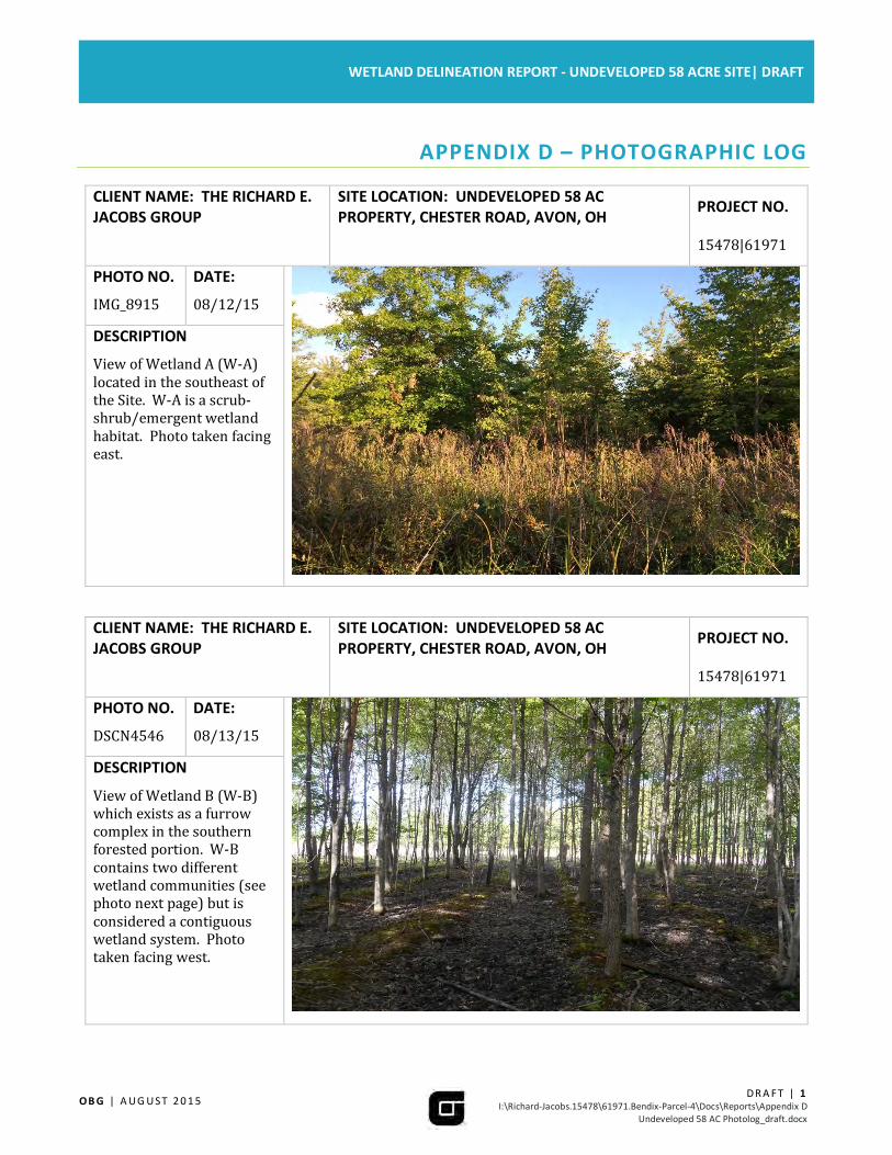
CLIENT NAME: THE RICHARD E.
JACOBS GROUP
SITE LOCATION: UNDEVELOPED 58 AC
PROPERTY, CHESTER ROAD, AVON, OH PROJECT NO.
15478|61971
PHOTO NO.
IMG_8915
DATE:
08/12/15
DESCRIPTION
View of Wetland A (W-A)
located in the southeast of
the Site. W-A is a scrub-
shrub/emergent wetland
habitat. Photo taken facing
east.
CLIENT NAME: THE RICHARD E.
JACOBS GROUP
SITE LOCATION: UNDEVELOPED 58 AC
PROPERTY, CHESTER ROAD, AVON, OH PROJECT NO.
15478|61971
PHOTO NO.
DSCN4546
DATE:
08/13/15
DESCRIPTION
View of Wetland B (W-B)
which exists as a furrow
complex in the southern
forested portion. W-B
contains two different
wetland communities (see
photo next page) but is
considered a contiguous
wetland system. Photo
taken facing west.

OB G | A U G U S T 2 0 1 5
DR A F T | 2I:\Richard-Jacobs.15478\61971.Bendix-Parcel-4\Docs\Reports\Appendix D
Undeveloped 58 AC Photolog_draft.docx
WETLAND DELINEATION REPORT - UNDEVELOPED 58 ACRE SITE| DRAFT
CLIENT NAME: THE RICHARD E.
JACOBS GROUP
SITE LOCATION: UNDEVELOPED 58 AC
PROPERTY, CHESTER ROAD, AVON, OH PROJECT NO.
15478|61971
PHOTO NO.
DSCN4558
DATE:
08/13/15
DESCRIPTION
View of the scrub-
shrub/emergent wetland
community contained in
W-B to the north. Photo
taken facing west.
CLIENT NAME: THE RICHARD E.
JACOBS GROUP
SITE LOCATION: UNDEVELOPED 58 AC
PROPERTY, CHESTER ROAD, AVON, OH PROJECT NO.
15478|61971
PHOTO NO.
IMG_8906
DATE:
08/12/15
DESCRIPTION
View of Wetland G (W-G)
located in the central
portion of the Site. W-G is
comprised of a furrow
running north-south within
a forested portion of the
Site. Photo taken facing
south.

OB G | A U G U S T 2 0 1 5
DR A F T | 3I:\Richard-Jacobs.15478\61971.Bendix-Parcel-4\Docs\Reports\Appendix D
Undeveloped 58 AC Photolog_draft.docx
WETLAND DELINEATION REPORT - UNDEVELOPED 58 ACRE SITE| DRAFT
CLIENT NAME: THE RICHARD E.
JACOBS GROUP
SITE LOCATION: UNDEVELOPED 58 AC
PROPERTY, CHESTER ROAD, AVON, OH PROJECT NO.
15478|61971
PHOTO NO.
IMG_8888
DATE:
08/12/15
DESCRIPTION
Wetland H (W-H) is
representative of an
emergent wetland habitat
located adjacent to the
north-south running
furrow Wetlands G, I, and K.
Photo taken facing east.
CLIENT NAME: THE RICHARD E.
JACOBS GROUP
SITE LOCATION: UNDEVELOPED 58 AC
PROPERTY, CHESTER ROAD, AVON, OH PROJECT NO.
15478|61971
PHOTO NO.
DSCN4564
DATE:
08/13/15
DESCRIPTION
View of Wetland H1 (W-
H1) located in the northern
portion of the Site. The
photo depicts the PFO
habitat of W-H1. Note the
water-stained leaves
prominent in the
foreground; this was the
main hydrologic indicator
found in this area of W-H1.
Photo taken facing west.

OB G | A U G U S T 2 0 1 5
DR A F T | 4I:\Richard-Jacobs.15478\61971.Bendix-Parcel-4\Docs\Reports\Appendix D
Undeveloped 58 AC Photolog_draft.docx
WETLAND DELINEATION REPORT - UNDEVELOPED 58 ACRE SITE| DRAFT
CLIENT NAME: THE RICHARD E.
JACOBS GROUP
SITE LOCATION: UNDEVELOPED 58 AC
PROPERTY, CHESTER ROAD, AVON, OH PROJECT NO.
15478|61971
PHOTO NO.
DSCN4573
DATE:
08/13/15
DESCRIPTION
View of PFO/PEM wetland
habitat located in W-H1.
This wetland community is
located in the northwest
corner of the Site, and was
not identified during the
previous delineation
(2010) by others. Photo
taken facing north.
CLIENT NAME: THE RICHARD E.
JACOBS GROUP
SITE LOCATION: UNDEVELOPED 58 AC
PROPERTY, CHESTER ROAD, AVON, OH PROJECT NO.
15478|61971
PHOTO NO.
IMG_8896
DATE:
08/12/15
DESCRIPTION
View of Wetland I (W-I)
which is composed of a
furrow within a forested
portion of the Site. W-I is
located in the central
portion of the site adjacent
to Wetlands G and K. Photo
taken facing south.

OB G | A U G U S T 2 0 1 5
DR A F T | 5I:\Richard-Jacobs.15478\61971.Bendix-Parcel-4\Docs\Reports\Appendix D
Undeveloped 58 AC Photolog_draft.docx
WETLAND DELINEATION REPORT - UNDEVELOPED 58 ACRE SITE| DRAFT
CLIENT NAME: THE RICHARD E.
JACOBS GROUP
SITE LOCATION: UNDEVELOPED 58 AC
PROPERTY, CHESTER ROAD, AVON, OH PROJECT NO.
15478|61971
PHOTO NO.
IMG_8872
DATE:
08/12/15
DESCRIPTION
View of Wetland K (W-K)
which consists of a furrow
and exists adjacent to
Wetlands I and K. Photo
taken facing south.
CLIENT NAME: THE RICHARD E.
JACOBS GROUP
SITE LOCATION: UNDEVELOPED 58 AC
PROPERTY, CHESTER ROAD, AVON, OH PROJECT NO.
15478|61971
PHOTO NO.
DSCN4540
DATE:
08/13/15
DESCRIPTION
View of Wetland L (W-L)
which is composed of
furrows and resides just
north of Chester Road;
southern portion of the
Site. Photo taken facing
north.

OB G | A U G U S T 2 0 1 5
DR A F T | 6I:\Richard-Jacobs.15478\61971.Bendix-Parcel-4\Docs\Reports\Appendix D
Undeveloped 58 AC Photolog_draft.docx
WETLAND DELINEATION REPORT - UNDEVELOPED 58 ACRE SITE| DRAFT
CLIENT NAME: THE RICHARD E.
JACOBS GROUP
SITE LOCATION: UNDEVELOPED 58 AC
PROPERTY, CHESTER ROAD, AVON, OH PROJECT NO.
15478|61971
PHOTO NO.
DSCN4509
DATE:
08/12/15
DESCRIPTION
View of Wetland R (W-R)
which is composed of a
furrow complex and resides
in the western portion of
the Site. Photo taken facing
north.
CLIENT NAME: THE RICHARD E.
JACOBS GROUP
SITE LOCATION: UNDEVELOPED 58 AC
PROPERTY, CHESTER ROAD, AVON, OH PROJECT NO.
15478|61971
PHOTO NO.
DSCN4524
DATE:
08/12/15
DESCRIPTION
Alternate view of W-R, the
southern portion of W-R
consist of a mainly
emergent wetland
community as shown. W-R
here also exists as a furrow
complex just with a more
scrub-shrub/emergent
habitat. Photo taken facing
west.

OB G | A U G U S T 2 0 1 5
DR A F T | 7I:\Richard-Jacobs.15478\61971.Bendix-Parcel-4\Docs\Reports\Appendix D
Undeveloped 58 AC Photolog_draft.docx
WETLAND DELINEATION REPORT - UNDEVELOPED 58 ACRE SITE| DRAFT
CLIENT NAME: THE RICHARD E.
JACOBS GROUP
SITE LOCATION: UNDEVELOPED 58 AC
PROPERTY, CHESTER ROAD, AVON, OH PROJECT NO.
15478|61971
PHOTO NO.
DSCN2758
DATE:
08/05/15
DESCRIPTION
View of Stream 1 (S-1) a
perennial tributary on-Site.
Photo taken facing north.
CLIENT NAME: THE RICHARD E.
JACOBS GROUP
SITE LOCATION: UNDEVELOPED 58 AC
PROPERTY, CHESTER ROAD, AVON, OH PROJECT NO.
15478|61971
PHOTO NO.
DSCN4577
DATE:
08/13/15
DESCRIPTION
Stream 2 (S-2) an
ephemeral tributary on-Site
that flows along the north
and western boundary.
Photo taken facing
southeast.

Chester Road Office Complex Photographed May 26, 27, and 29, 2015
Photo 1. Wetland A facing north.
Photo 2. Furrowed portion of Wetland B.

Chester Road Office Complex Photographed May 26, 27, and 29, 2015
Photo 3. Wetland B facing southeast.
Photo 4. Wetland G facing northwest.
Chester Road Office Complex Photographed May 26, 27, and 29, 2015
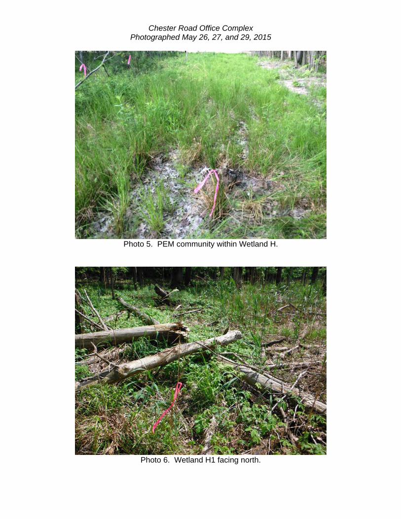
Photo 5. PEM community within Wetland H.
Photo 6. Wetland H1 facing north.

Chester Road Office Complex Photographed May 26, 27, and 29, 2015
Photo 7. Wetland H1 facing west.
Photo 8. Wetland I facing north.

Chester Road Office Complex Photographed May 26, 27, and 29, 2015
Photo 9. Wetland K facing south.
Photo 10. Wetland L facing west.

Chester Road Office Complex Photographed May 26, 27, and 29, 2015
Photo 11. Wetland R facing south.
Photo 12. Wetland R facing west.

Chester Road Office Complex Photographed May 26, 27, and 29, 2015
Photo 13. Wetland W facing east.
Photo 14. Stream S-1 facing south upstream.

Chester Road Office Complex Photographed May 26, 27, and 29, 2015
Photo 15. Stream S-2, facing north downstream.
Photo 16. Stream S-3 facing south, upstream.

Chester Road Office Complex Photographed May 26, 27, and 29, 2015
Photo 17. Upland forest community within the project area.
Photo 18. Open field community within the project area.

Chester Road Office Complex Photographed May 26, 27, and 29, 2015
Photo 19. Old field community within the project area.
Photo 20. Agricultural field within the project area.