appendix e -marine casualty analysis
TRANSCRIPT
Appendix E - Marine Casualty Analysis The Coast Guard reviewed its marine casualty database for the 2005 to 2016 timeframe and
found numerous reportable marine casualties in the Bering Sea and adjacent areas. As the traffic volume
in the study area is light, with a corresponding low number of marine casualties, the Coast Guard
included data from an area of western Alaskan waters that is larger than the PARS study area in order to
obtain a representative sample of the types of incidents that might occur. The vast majority of marine
casualties involved commercial fishing vessels and mishaps leading to the injury of a member of the
crew. The Coast Guard omitted accidents of this nature, as they are not preventable by ship routing
measures. The enclosed list of marine casualties and subsequent analysis are from marine casualties
meeting the following criteria: Occurred between 2005 and 2016, involved a commercial vessel other
than a fishing vessel engaged in fishing, and did not involve an injury, controlled substance investigation,
or other type of administrative investigation. The resulting list of 144 marine casualties revealed an
accident history that the Coast Guard believes is representative of nearly any coastal environment with
commercial vessel traffic.
The Coast Guard identified 38 incidents of reported commercial vessel groundings over this 10-
year period, representing 26% of the marine casualties determined to be relevant for the purpose of this
study. Most of these involved tug/barge traffic operating either in shallow, near shore environments or
on river systems such as the Yukon, Kuskokwim and Naknek Rivers. This accident trend is normal and
mirrors other parts of the country where vessel groundings are most common in shallow near coastal
waters with reduced under keel clearances. As noted elsewhere in this study, much of western Alaska's
Coastal waters have not been surveyed to modern standards. The Coast Pilot for this region specifically
addresses this issue by noting " ... charts must not be relied upon to closely, especially near shore."
Closer review of the 38 grounding incidents identified three vessel groundings directly
attributed to incorrect charts. This does illustrate that charts based on unreliable hydrographic data are
playing a role in vessel groundings, but it is difficult to quantify how much of a role it is playing without a
baseline measure of groundings-per-transit. There are however, two notable exceptions to the typical
profile of a tug/barge/landing craft grounding in a near-shore or river environment that are particularly
informative to this report.
Grounding #1 (Casualty# 132): In July of 2015, a 9,300 gross ton research vessel with a draft of
27 feet struck an incorrectly charted area of shoal water near Dutch Harbor, Alaska, sustaining a hull
fracture approximately 39 inches long and two inches wide. No injuries or pollution was associated with
this accident. The vessel had just begun a voyage from Dutch Harbor, AK intending to transit the Bering
Strait and continue on to the Chukchi Sea to participate in Outer Continental Shelf (OCS) exploratory
drilling. The hydrographic survey information in the area of the grounding dated back to 1935. A NOAA
Coast Survey ship was able to investigate immediately. While the chart showed shoal water with a least
depth of 5 ~fathoms, or 31.5 feet, the actual depth was determined to be as little as 3 % fathoms, or
22.5 feet.
63

The following figure illustrates how modern multi-beam hydrographic survey techniques can
identify unknown hazards to navigation.
_..,
~ I
4 r-· • C l
Rock and Sounding DtoN Recommendations
NOT FOR NAVIGATION 16
17
Unexploded ()(dnance (reported 2013)
(see 00/eJ
15
Figure 13: Example of modern multi-beam survey report finding previously uncharted dangers to
navigation.
Grounding #2 (Casualty# 142):
20
5
In June of 2016, an oil tanker carrying refined petroleum products grounded approximately 10
miles from shore, southeast of Nunivak Island, AK. This 598 foot ·long, 27,500 gross ton, double hulled
tanker was carrying in excess of 11 million gallons of fuel, a combination of bunker fuel, #2 fuel oil, and
gasoline. At the time of the grounding, the ship was drawing 10.4 meters, or 34.2 feet forward, and 11.5
meters, or 37.3 feet aft. Charted depths in the area showed 9 fathoms, or 54 feet. The vessel was
transiting at a slow speed of about four nautical miles per hour and refloated on a rising tide shortly
after the grounding occurred. No pollution or injuries were associated with this accident. The grounding
was attributed the vessel striking an uncharted shoal. Hydrographic survey information in the area of
the grounding is of unknown origin, possibly dating back to a time prior to the purchase of Alaska from
Russia in 1867. Single and double hulled oil tankers have been in use for many years to refuel foreign
flagged, distant water fishing fleets operating in the western Bering Sea, but their use in lightering
operations to transport fuel to western Alaska coastal communities is a relatively new development,
64

dating back to about 2012. Prior to that time, the typical method of delivery was almost exclusively
through use of US flagged tugs and tank barges.
These two grounding incidents are reflective of the type of risk that the Coast Guard believes
ship routing measures can mitigate. Identification of ship routing measures and investment in the form
of modern hydrographic survey work will provide mariners with a more thorough understanding of the
marine environment in which they operate and encourage vessel operators, where it is possible, to
avoid areas that may have uncharted hazards. It is notable that both of these groundings are recent,
involved vessels that did not have a long history of operating in the Bering Sea region, and were engaged
in types of maritime activity that has only recently emerged. Any future significant increase in the
number of vessels transiting the Bering Strait will include vessels with these same characteristics. Thus,
installing routing measures now might help prevent future similar mishaps.
The 60 incidents in which a vessel lost all or partial mobility represent over 41% of the identified
marine casualties. In 27 of these incidents, representing 19% of the 144 casualties, vessels completely
lost either propulsion or steering. The exact causes vary widely but are usually the result of equipment
failure to a vessel's propulsion plant or ship control systems. Regardless of the exact nature, in cases of a
complete loss of mobility, the result is the same. The vessel is no longer able to travel where intended
and is subject to winds and currents. Given enough time, the vessel might eventually drift to shallow
water and ground. In some areas ofthe Bering Sea, the consequences arising from a loss of mobility
casualty leading to a vessel grounding can be more severe than in other areas, since in many areas
vessel traffic is sparse and response resources may be too far away to offer successful towing or salvage
assistance before a situation deteriorates.
Some countries have developed routing measures that include some amount of "standoff
distance" from the coast in order to afford additional response time for loss of mobility events. A good
example of this in Arctic waters is off the North coast of Norway, where routing measures were installed
for large ships (5,000 GT or larger) and tank ships to keep them further off the coast. Norway's routing
measures intend to provide additional time before a vessel encounters shoal water in the event a
navigational error took the ship off course, and provide additional time to respond to a loss of
propulsion incident. The Coast Guard took a similar approach in developing proposed routing measures
that will keep ships further offshore in areas of particular environmental or navigational concern for the
same reasons, while minimizing the overall increase in the length of the voyage. The preliminary
orientation of the proposed two-way route maximizes this "stand-off" distances at the closest
approaches to land at both King Island and Fairway Rock. In both of these locations, the centerline of
the two-way route is approximately 7.8 nautical miles away from each island, and the outer boundary of
the two-way route is approximately 5.8 nautical miles away from the islands.
Four incidents(# 19, 86, 94, 135) involved either a tug colliding with its own barge or a
collision between a tug/barge and a fishing vessel. The Coast Guard believes incidents such as these are
unlikely to occur within the proposed two-way route since existing traffic patterns for tug/barge traffic
are closer to shore. Most tug/barge traffic is "destinational" in nature to deliver supplies to coastal
communities, and the Coast Guard believes it is unlikely that tug and barge traffic will choose to follow a
65
route well offshore even if routing measures are established. One incident (#53) involved vessels
colliding while intentionally approaching to offload cargo. This type of activity is also unlikely to occur
near the location of the proposed route.
Casualties #13 and 27, while representing less than 2% of the marine casualties reviewed, do
provide evidence that collisions between ships carrying cargo and fishing vessels do occur in western
Alaska, albeit infrequently. One must look much earlier into the accident history to find other useful
examples. On March 3, 2003, the fishing vessel Katrina Em and the 617' containership Arkona Trader,
both transiting Unimak Pass, were involved in a collision that significantly damaged the fishing vessel. In
September of 1983, two Korean flagged freighters, the 551' bulk carrier Pan Nova and the M/V Swibon
were involved in a collision in Unimak Pass. The collision occurred in the early morning hours before
sunrise, but environmental conditions were good, with 10 knot winds, 2 foot seas, and 12 mile visibility.
Response efforts rescued the crew of 26, but attempts to salvage the Pan Nova were unsuccessful and
the ship ultimately sank due to damage resulting from the collision. While collisions occur with far less
frequency than loss of maneuverability incidents, their consequences can be far more severe, with most
damage occurring immediately, and subsequent damage due to fire, flooding and loss of vessel stability
potentially occurring at an accelerated pace.
Since the proposed route crosses productive commercial fishing grounds in the southern Bering
Sea, any future increase in traffic bound to or from the Bering Strait will result in increased interactions
between fishing vessels and other large vessel traffic. The Coast Guard believes the proposed two-way
route in this area offers definite advantages to these vessel interactions. Fishing vessels would know
where to expect larger vessel traffic, which may be moving at much higher speeds than the other fishing
vessels in the area. Display of routing measure boundaries on nautical charts and electronic charting
displays will allow vessels to quickly determine whether another vessel is following the two-way route or
not. This, in turn, affords more time for vessels to coordinate passing arrangements in situations where
risk of collision exists.
With specific consideration toward reducing the risk of vessel collisions, the Coast Guard did
consider other possible routing measures, such as a traffic separation scheme that would include a
traffic separation zone. This type of measure would result in better separation of vessel traffic travelling
in different directions, but it would limit the amount of sea room available for collision and ice
avoidance. In the areas where high densities of commercial fishing activity exist, the Coast Guard
believes that in the near term, implementation of a Traffic Separation Scheme could actually increase
the risk of collisions. The reason for this is that the Traffic Separation Scheme alters the responsibilities
between vessels for avoiding collisions. In a scenario with no routing measures, or in the case of a two
way route, a commercial ship is obligated under COLREGS to avoid vessels that are actually fishing. In a
scenario with a traffic separation scheme, fishing vessels are obliged to avoid impeding the passage of
other vessels that are following the lane of a traffic separation scheme. Currently, and for the near
future, there are far more fishing vessels operating in the area where the two-way route crosses the
fishing grounds. Most of them do not expect to see vessels other than other fishing vessels, but they do
expect that they will have the right of way under COLREGS when they are actively fishing in this area and
encounter another vessel that is not also fishing. Implementing a traffic separation scheme can thus
66

create a scenario could create a situation where two vessels (one actively fishing, one following a traffic
separations scheme lane) might both believe they have the right of way. In a future scenario, where use
of the routing measure by vessel traffic bound to or from the Bering Strait becomes more frequent, this
is less of a concern.
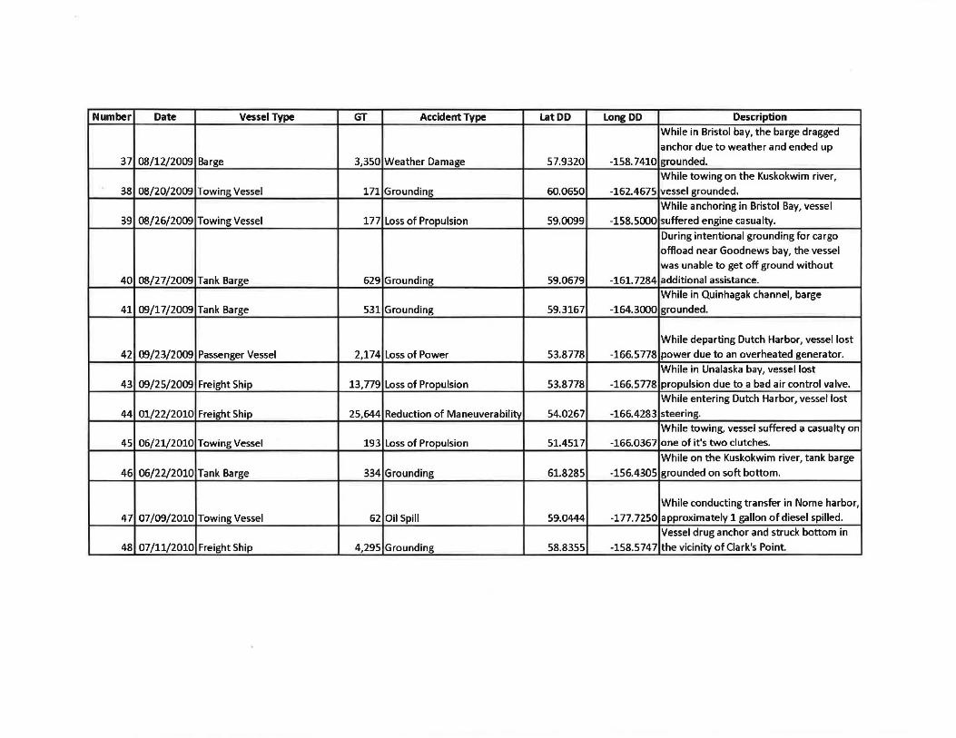
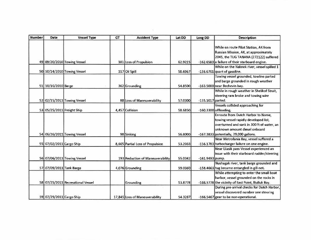
Detailed information on marine casualties follows:
67

1-- Proposed Route I
Russia
"67 132 133 81
~~335~~2 7~1 43 ,,.. HBG 140
Z623 100
144
4 44
35 25
Marine Casualties 2005 - 2016
84
143
St. Lawrence Is.
129
117 66 Nome
63 69
Red Dog Mine
85
~otzebue
15 1C!9 95
49
80 141
83 Alaska 11 46
6 78 92
3.1 107
120
Nunivak Is. 142
41
28
76 7
36
Bethel 93
91 94
38
40
62
125
109 106 39 122 57 48 137 87 79 119 50 135 126
134 *" 19 ~0 37 ~~
53

Number Date Vessel Type GT Accident Type Lat DD Long DD Description
While underway, hotwork ignited wood-1 04/08/2005 Cargo Ship 24,479 Fire 53.7650 -178.8700 pulp cargo in hold #1.
While unloading onshore at Scan Bay, the wind pushed vessel onto a rock, resulting
2 08/08/2005 Freight Ship 76 Grounding 53.6233 -167.0750 in minor damage to the hull.
While recovering fishing gear near shore,
the vessel grounded on Eider Reef.
Grounding re-open previously damage 3 09/22/2005 Freight Ship 76 Grounding 53.9500 -166.6000 section of hull.
While in Dutch Harbor, vessel engine
suffered overheat and shut-down. Vessel
4 06/09/2006 Cargo Ship 4,964 Loss of Propulsion 54.0167 -166.4667 towed to berth for repairs. On deck hydraulic pump leak resulting in
5 07 /10/2006 Cargo Ship 17,845 Equipment Failure 59.1450 -174.2100 10 gallons hydraulic oil spilled.
During transfer on Kashunuk River less
than 1 gallon of#l diesel spilled, created
6 07/17/2006 Tank Barge 495 Oil Spill 61.5167 -166.1000 sheen.
While in Bristol Bay a cargo deck spill from ISO container on deck of freight barge
7 08/2 7 /2006 Barge 1,856 Oil Spill 56.4167 -168.1333 resulted in 250 gallon diesel spill.
Vessel hit a rock in St. George harbor, unconfirmed spill of 5 gallons of Number 4
8 08/28/2006 Towing Vessel 146 Grounding 56.0569 -168.5214 fuel oil. While underway one propulsion pod
9 09/05/2006 Passenger Vessel 48,075 Reduction of Maneuverability 55.7099 -157.5150 suffered mechanical damage.
While anchored near Unalaska, vessel
10 10/12/2006 Cargo Ship 4,392 Weather Damage 53.8778 -166.5778 dragged anchor. Near Adak Harbor, a bearing on the
starboard seized, shutting down one
11 01/23/2007 Towing Vessel 198 Reduction of Maneuverability 51.8500 -176.6333 engine.
While underway in Bering Sea, a wave
12 02/03/2007 Offshore Supply Vessel 3,534 Weather Damage 52.0000 -175.5000 broke loose a life-raft.

Number Date Vessel Type GT Accident Type lat DD Long DD Description
During extreme weather near Adak, F/T
SEA FISHER collided with M/V Khana 13 02/04/2007 Cargo Ship 3,475 Collision 51.5917 -176.6000 causing damage to both vessels.
While riding out a storm near Dutch
Harbor, vessel suffered clogged fuel filters
14 03/09/2007 Cargo Ship 7,207 Loss of Propulsion 53.8778 -166.5778 and lost all engines and generators.
Muddy bottom grounding while towing
15 06/03/2007 Towing Vessel 76 Grounding 63.5651 -165.0548 alongside. No damage.
Near Sand Point, vessel suffered engine
cooler failure resulting in a partial loss of
16 06/04/2007 Towing Vessel 143 Loss of Propulsion 55.3330 -160.5000 propulsion.
Near Aniak, barge struck submerged
object holing barge resulting in an 50
17 06/12/2007 Tank Barge 495 Grounding 61.9667 -159.8833 gallon oil spill.
While underway in Unimak Pass, vessel
suffered loss of power due to an engine
18 06/20/2007 Research Vessel 195 Loss of Power 54.3667 -165.4167 casualty on its generator.
On the Naknek river, the F/V ALCHEMIST
and MALOLO collided dealing damage to
19 07/13/2007 Towing Vessel 188 Collision 58.6967 -156.6761 both vessels, but not the towed barge.
Oil leaked from a small boat's hydraulic
system where it discharged into the
Chukchi Sea forming a sheen on the
20 08/04/2007 Research Vessel 3,779 Oil Spill 59.0444 -177.7250 surface.
While entering Dutch Harbor, vessel
switched to Heavy Fuel Oil, causing
21 09/06/2007 Cargo Ship 5,286 Loss of Propulsion 54.0733 -166.3467 engines to shut-down.
While in Dutch Harbor, an a-ring blew off
the air system causing the main engine to
22 09/07/2007 Cargo Ship 6,670 Loss of Propulsion 53.8778 -166.5778 shut-down.
23 09/12/2007 Cargo Ship 5,286 Partial Loss of Propulsion 53.8778 -166.5778 No data.

Number Date Vessel Type GT Accident Type Lat DD Long DD Description While in Shelikof Strait, shut one engine
24 09/13/2007 Passenger Vessel 2,174 Partial Loss of Propulsion 57.2150 -155.3083 down for repairs. Barge broke free from moorings and
25 10/04/2007 Barge 2,898 Grounding 53.9047 -166.4462 grounded in Summers Bay. While in Dutch Harbor, vessel service
26 10/07/2007 Mobile Offshore Drilling Unit 10,264 Equipment Failure 53.8778 -166.5778 generators shut down. While near Adak, the SEAFREEZE ALASKA
27 10/26/2007 Cargo Ship 3,264 Collision 51.8575 -176.6459 collided with the JACHA. While in Bering Sea, lost of control of controllable pitch propeller due to frozen
28 01/17/2008 Misc. Vessel 187 Loss of Propulsion 57.1167 -168.9333 control air lines. While near Adak, the vessel spilled 100
29 01/26/2008 Cargo Ship 188 Oil Spill 51.8575 -176.6459 gallons of diesel. Enroute to Dutch Harbor vessel experience loss of CPP control due to water in CPP
30 07/05/2008 Research Vessel 370 Loss of Propulsion 59.0444 -177.7250 system. Meykoyruk Beach, loss of hull integrity resulted in an estimated 50-100 gallon
31 09/27/2008 Freight Ship 95 Grounding 60.3867 -166.1750 diesel spilled. While in the Gulf of Alaska, vessel shut-down one engine due to high cooling
32 11/10/2008 Passenger Vessel 2,174 Partial Loss of Propulsion 54.4911 -165.3621 water temperature.
While departing Dutch Harbor, vessel
33 02/08/2009 Misc. Vessel 111 Grounding 53.8778 -166.5778 grounded. While enroute to Dutch Harbor, vessel lost
34 03/18/2009 Cargo Ship 4,988 Loss of Propulsion 53.8778 -166.5778 propulsion. While underway in the Bering sea, the
35 07/14/2009 Freight Ship 37,150 Loss of Power 53.9200 -166.4667 auxiliary generator tripped offline. While on the Kuskokwim river, tug grounded and subsequently collided with
36 08/11/2009 Towing Vessel 171 Grounding 60.9833 -161.5000 it's towed barge.
Number Date Vessel Type GT Accident Type Lat DD Long DD Description While in Bristol bay, the barge dragged
anchor due to weather and ended up 37 08/12/2009 Barge 3,350 Weather Damage 57.9320 -158. 7410 grounded.
While towing on the Kuskokwim river,
38 08/20/2009 Towing Vessel 171 Grounding 60.0650 -162.4675 vessel grounded.
While anchoring in Bristol Bay, vessel
39 08/26/2009 Towing Vessel 177 Loss of Propulsion 59.0099 -158.5000 suffered engine casualty.
During intentional grounding for cargo
offload near Goodnews bay, the vessel was unable to get off ground without
40 08/27/2009 Tank Barge 629 Grounding 59.0679 -161.7284 additional assistance.
While in Quinhagak channel, barge
41 09/17/2009 Tank Barge 531 Grounding 59.3167 -164.3000 grounded.
While departing Dutch Harbor, vessel lost
42 09/23/2009 Passenger Vessel 2,174 Loss of Power 53.8778 -166.5778 power due to an overheated generator.
While in Unalaska bay, vessel lost
43 09/25/2009 Freight Ship 13,779 Loss of Propulsion 53.8778 -166.5778 propulsion due to a bad air control valve. While entering Dutch Harbor, vessel lost
44 01/22/2010 Freight Ship 25,644 Reduction of Maneuverability 54.0267 -166.4283 steering.
While towing, vessel suffered a casualty on
45 06/21/2010 Towing Vessel 193 Loss of Propulsion 51.4517 -166.0367 one of it's two clutches.
While on the Kuskokwim river, tank barge
46 06/22/2010 Tank Barge 334 Grounding 61.8285 -156.4305 grounded on soft bottom.
While conducting transfer in Nome harbor,
47 07/09/2010 Towing Vessel 62 Oil Spill 59.0444 -177.7250 approximately 1 gallon of diesel spilled.
Vessel drug anchor and struck bottom in
48 07/11/2010 Freight Ship 4,295 Grounding 58.8355 -158.5747 the vicinity of Clark's Point
Number Date Vessel Type GT Accident Type Lat DD Long DD Description
While en route Pilot Station, AK from
Russian Mission, AK, at approximately
2045, the TUG TANANA (2n122) suffered
49 09/20/2010 Towing Vessel 181 Loss of Propulsion 62.9215 -162.6583 a failure of their starboard engine.
While on the Naknek river, vessel spilled 1 50 10/14/2010 Towing Vessel 117 Oil Spill 58.6967 -156.6761 quart of gasoline.
Towing vessel grounded, towline parted
and barge grounded in rough weather
51 10/16/2010 Barge 362 Grounding 54.8SOO -163.SOOO near Bechevin bay.
While in rough weather in Shelikof Strait,
steering ram broke and towing wire
52 02/lS/2011 Towing Vessel 88 Loss of Maneuverability 57.0300 -155.1017 parted.
Vessels collided approaching for
S3 OS/25/2011 Freight Ship 4,457 Collision 58.6850 -160.3300 offloading.
Enroute from Dutch Harbor to Nome,
towing vessel rapidly developed list,
overturned and sank in 300 ft of water, an
unknown amount diesel onboard
S4 06/26/2011 Towing Vessel 98 Sinking S6.8000 -167.3833 potentially, 29,000 gallons.
Near Metrofania Bay, vessel suffered a
SS 07/02/2011 Cargo Ship 8,665 Partial Loss of Propulsion 53.2033 -156.1783 turbocharger failure on one engine.
Near Liiasik pass Vessel experienced an
issue with their starboard rudder/steering
56 07/06/2011 Towing Vessel 193 Reduction of Maneuverability SS.0342 -161.9493 pump.
Nushagak river, tank barge grounded and
57 07/09/2011 Tank Barge 4,076 Grounding 59.0360 -158.4663 tug became entangled in gill-net.
While attempting to enter the small boat
harbor, vessel grounded on the rocks in
58 07/2S/2011 Recreational Vessel Grounding 53.8778 -166.5778 the vicinity of East Point, lliuliuk Bay.
During pre-arrival checks for Dutch Harbor,
vessel discovered number one steering
59 07/29/2011 Cargo Ship 17,84S Loss of Maneuverability S4.3267 -166.5467 gear to be non-operational.
Number Date Vessel Type GT Accident Type Lat DD Long DD Description
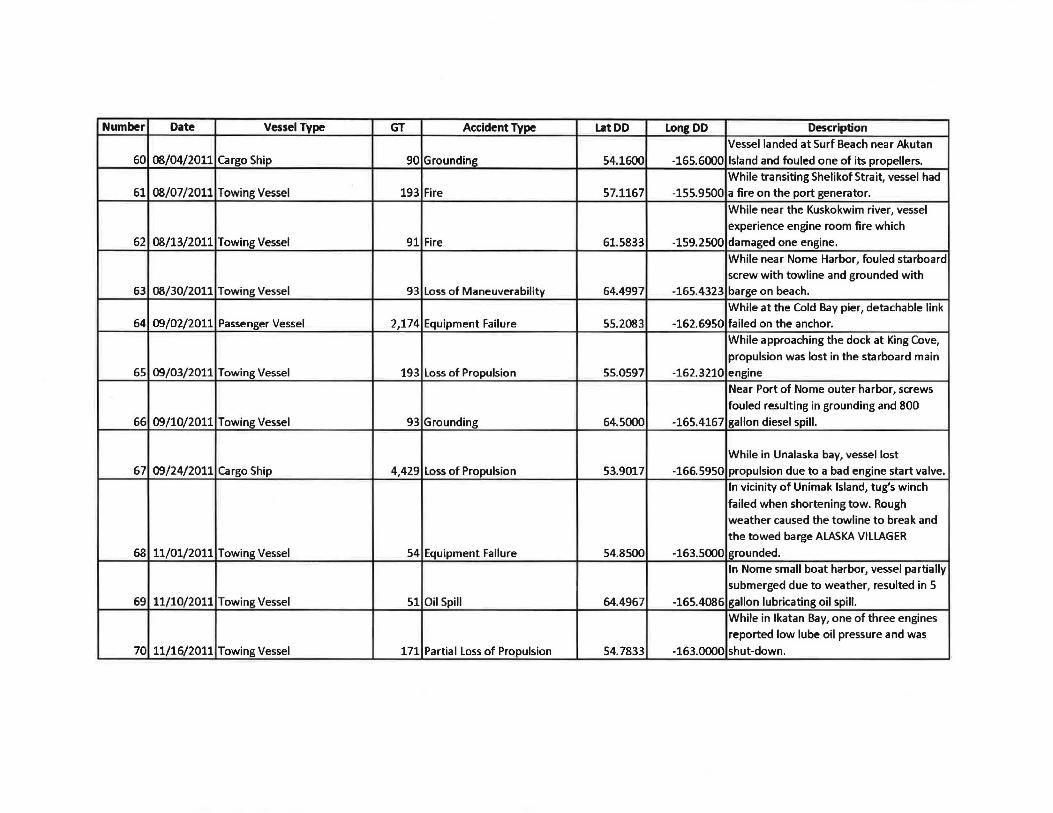
Vessel landed at Surf Beach near Akutan 60 08/04/2011 Cargo Ship 90 Grounding 54.1600 -165.6000 Island and fouled one of its propellers.
While transiting Shelikof Strait, vessel had 61 08/07/2011 Towing Vessel 193 Fire 57.1167 -155.9500 a fire on the port generator.
While near the Kuskokwim river, vessel
experience engine room fire which
62 08/13/2011 Towing Vessel 91 Fire 61.5833 -159.2500 damaged one engine.
While near Nome Harbor, fouled starboard screw with towline and grounded with
63 08/30/2011 Towing Vessel 93 Loss of Maneuverability 64.4997 -165.4323 barge on beach.
While at the Cold Bay pier, detachable link 64 09/02/2011 Passenger Vessel 2,174 Equipment Failure 55.2083 -162.6950 failed on the anchor.
While approaching the dock at King Cove,
propulsion was lost in the starboard main
65 09/03/2011 Towing Vessel 193 Loss of Propulsion 55.0597 -162.3210 engine Near Port of Nome outer harbor, screws
fouled resulting in grounding and 800
66 09/10/2011 Towing Vessel 93 Grounding 64.5000 -165.4167 gallon diesel spill.
While in Unalaska bay, vessel lost
67 09/24/2011 Cargo Ship 4,429 Loss of Propulsion 53.9017 -166.5950 propulsion due to a bad engine start valve. In vicinity of Unimak Island, tug's winch
failed when shortening tow. Rough weather caused the towline to break and the towed barge ALASKA VILLAGER
68 11/01/2011 Towing Vessel 54 Equipment Failure 54.8500 -163.5000 grounded. In Nome small boat harbor, vessel partially
submerged due to weather, resulted in 5
69 11/10/2011 Towing Vessel 51 Oil Spill 64.4967 -165.4086 gallon lubricating oil spill.
While in lkatan Bay, one of three engines
reported low lube oil pressure and was
70 11/16/2011 Towing Vessel 171 Partial Loss of Propulsion 54.7833 -163.0000 shut-down.
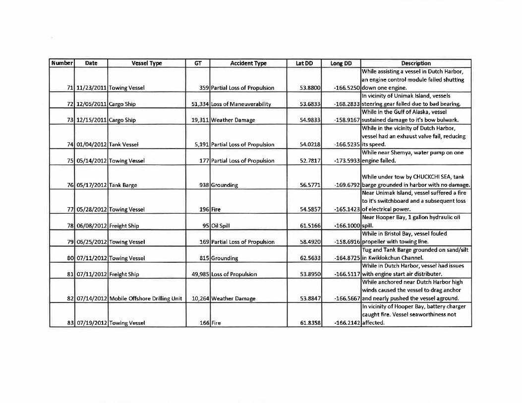
Number Date Vessel Type GT Accident Type lat DD Long DD Description While assisting a vessel in Dutch Harbor,
an engine control module failed shutting
71 11/23/2011 Towing Vessel 359 Partial Loss of Propulsion 53.8800 -166.5250 down one engine. In vicinity of Unimak Island, vessels
72 12/05/2011 Cargo Ship 51,334 Loss of Maneuverability 53.6833 -168.2833 steering gear failed due to bad bearing.
While in the Gulf of Alaska, vessel
73 12/15/2011 Cargo Ship 19,311 Weather Damage 54.9833 -158.9167 sustained damage to it's bow bulwark.
While in the vicinity of Dutch Harbor,
vessel had an exhaust valve fail, reducing
74 01/04/2012 Tank Vessel 5,191 Partial Loss of Propulsion 54.0218 -166.5235 its speed.
While near Shemya, water pump on one
75 05/14/2012 Towing Vessel 177 Partial Loss of Propulsion 52.7817 -173.5933 engine failed.
While under tow by CHUCKCHI SEA, tank
76 05/17/2012 Tank Barge 938 Grounding 56.5771 -169.6792 barge grounded in harbor with no damage. Near Unimak Island, vessel suffered a fire
to it's switchboard and a subsequent loss
77 05/28/2012 Towing Vessel 196 Fire 54.5857 -165.1423 of electrical power.
Near Hooper Bay, 1 gallon hydraulic oil
78 06/08/2012 Freight Ship 95 Oil Spill 61.5166 -166.1000 spill .
While in Bristol Bay, vessel fouled
79 06/25/2012 Towing Vessel 169 Partial Loss of Propulsion 58.4920 -158.6916 propeller with towing line.
Tug and Tank Barge grounded on sand/silt
80 07/11/2012 Towing Vessel 815 Grounding 62.5633 -164.8725 in Kwiklokchun Channel. While in Dutch Harbor, vessel had issues
81 07/11/2012 Freight Ship 49,985 Loss of Propulsion 53.8950 -166.5117 with engine start air distributer.
While anchored near Dutch Harbor high
winds caused the vessel to drag anchor
82 07/14/2012 Mobile Offshore Drilling Unit 10,264 Weather Damage 53.8847 -166.5667 and nearly pushed the vessel aground.
In vicinity of Hooper Bay, battery charger
caught fire. Vessel seaworthiness not
83 07/19/2012 Towing Vessel 166 Fire 61.8358 -166.2142 affected.

Number Date Vessel Type GT Accident Type Lat DD Long DD Description
Between Point Barrow and Prudhoe Bay
an oily rag caught fire in the engine room.
84 08/02/2012 Towing Vessel 105 Fire 67.1600 -167.7467 Vessel seaworthiness not affected.
Near Kotzebue, barge grounded on bar
85 08/06/2012 Barge 1,474 Grounding 66.8672 -162.6277 due to heavy loading.
In Dutch Harbor tug and tank barge
86 08/07/2012 Towing Vessel 4,721 Collision 53.9000 -166.5333 collided while doing a personnel transfer.
Vessel grounded after departing from
87 08/16/2012 Towing Vessel 93 Grounding 59.0099 -158.5000 Bethel.
Worn tendering resulted in puncture of
88 08/29/2012 Tank Barge 4,076 Flooding 71.3483 -156.7900 the barge side-shell.
While towing in the Chukchi Sea, vessel
89 08/31/2012 Freight Ship 12,892 Weather Damage 68.7400 -167.9467 sustained weather damage.
Near Point Hope, towline parted due to
heavy weather. Barge was later recovered
90 09/17/2012 Towing Vessel 93 Barge Breakaway 68.3306 -166.8990 without damage.
91 09/17/2012 Towing Vessel 88 Grounding 60.6814 -161.9665 Vessel grounded on Kuskokwim river.
While transiting from Chivak to Hooper
bay the vessel lost one of three rudders
92 10/03/2012 Towing Vessel 169 Loss of Maneuverability 61.4783 -165.9667 due to a failed flange.
On the Kuskokwim river, barge was pulled off of the riverbank and subsequently sunk
93 10/04/2012 Barge 673 Flooding 60.8190 -161.4540 due to unknown damage.
Tug lost control of barge in Adak Harbor,
94 10/10/2012 Barge 1,469 Collision 60.7912 -161.7477 the barge collided with a skiff and sunk it.
Tug ran aground on reef near St. Michael
in Norton Sound. Unknown quantity of
95 10/12/2012 Towing Vessel 69 Grounding 63.5194 -162.0724 diesel spilled.
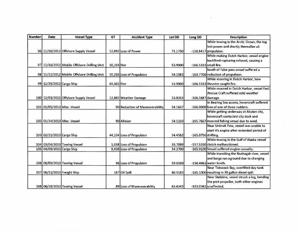
Number Date Vessel Type GT Accident Type Lat DD Long DD Description While towing in the Arctic Ocean, the tug
lost power and shortly thereafter all 96 11/10/2012 Offshore Supply Vessel 12,892 Loss of Power 71.1750 -158.8417 propulsion.
While making Dutch Harbor, vessel engine
backfired rupturing exhaust, causing a 97 11/16/2012 Mobile Offshore Drilling Unit 10,264 Fire 53.9000 -166.5333 small fire.
South of False pass vessel suffered a
98 11/22/2012 Mobile Offshore Drilling Unit 10,265 Loss of Propulsion 54.1983 -163.7700 reduction of propulsion.
While mooring in Dutch Harbor, bow 99 11/29/2012 Cargo Ship 64,502 Fire 53.9000 -166.5333 thruster caught fire.
While moored in Dutch Harbor, vessel Fast
Rescue Craft suffered cold weather
100 12/03/2012 Offshore Supply Vessel 12,892 Weather Damage 53.8353 -166.5687 damage.
In Bearing Sea access, hovercraft suffered 101 01/05/2013 Misc. Vessel 90 Reduction of Maneuverability 54.1667 -166.0000 loss of one of three rudders.
While getting underway at Akutan city,
hovercraft contacted city dock and
102 01/24/2013 Misc. Vessel 90 Allision 54.1333 -165. 7667 moored fishing vessel due to wind. Near Unimak Pass, vessel was unable to
start it's engine after extended period of
103 02/21/2013 Cargo Ship 44,234 Loss of Propulsion 54.4582 -165.0756 drifting. While towing in the Gulf of Alaska vessel
104 03/04/2013 Towing Vessel 1,038 Loss of Propulsion 55.7099 -157.5150 clutch malfunctioned.
105 04/09/2013 Cargo Ship 9,438 Loss of Propulsion 54.2700 -165.9100 Vessel suffered engine casualty. While transiting the Nushagak river, vessel
and barge ran aground due to changing 106 06/09/2013 Towing Vessel 96 Loss of Propulsion 59.0360 -158.4663 water levels.
Near Tokssook Bay, overfilled day-tank
107 06/11/2013 Freight Ship 187 Oil Spill 60.5183 -165.1000 resulting in 30 gallon diesel spill.
Near Stebbins, vessel struck a log, bending
the port propeller, both other engines 108 06/28/2013 Towing Vessel 89 Loss of Maneuverability 63.6345 -163.0362 unaffected.

Number Date Vessel Type GT Accident Type Lat DD Long DD Description
While transiting to Togiak, barge struck
unmarked boulder. Approximately 10
109 07/17/2013 Towing Vessel 629 Grounding 59.0556 -160.3167 gallons of #1 diesel spilled.
At Arctic Ocean access, vessel struck
unmarked sandbar after guide vessel
110 07/22/2013 Barge 1~083 Grounding 70.5922 -160.1392 missed it.
While anchored near Wales, AK, 1 gallon
111 07/24/2013 Tank Barge 495 Oil Spill 64.5820 -169.0635 of gasoline spilled.
Vessel broke loose from it's mooring and
112 07/26/2013 Barge 40 Grounding 69.6700 -163.1167 grounded.
In vicinity of St. Lawrence Island,
contaminated fuel caused the shut-down
113 08/13/2013 Towing Vessel 89 Loss of Propulsion 64.0667 -169.6283 of all engines onboard.
Greywater discharge in Arctic Ocean,
114 08/27/2013 Research Vessel 9,088 Oil Spill 68.3266 -167.6608 resulting in a sheen.
While in Unimak Pass vessel shut-down
115 10/02/2013 Cargo Ship 65,531 Loss of Propulsion 54.4911 -165.3621 main engine to make repairs.
Transiting from Dutch Harbor to Akutan,
vessel developed a list due to flooding
because of a bad gasket on a water-tight
116 10/04/2013 Towing Vessel 590 Flooding 54.2317 -165.8500 closure.
Spill during transfer near Norton Sound,
750 gallons of JP-5 into secondary
117 10/11/2013 Tank Barge 668 Oil Spill 64.6977 -165.1605 containment. No oil in the water.
Near King Cove, vessel voluntarily shut
down one engine due to excessive smoke
118 10/30/2013 Towing Vessel 198 Partial Loss of Propulsion 55.0563 -162.3192 because of bad fuel.
While getting underway at Dillingham
119 10/31/2013 Towing Vessel 117 Partial Loss of Propulsion 59.0342 -158.4747 vessel had an engine stall out.
While towing in Etolin Strait, worn
bearings on the reduction gear caused it to
120 11/05/2013 Passenger Vessel 88 Loss of Propulsion 60.5522 -165.2717 seize.

Number Date Vessel Type GT Accident Type Lat DD Long DD Description At Akun Island hovercraft ramp the shaft
121 11/17/2013 Passenger Vessel 90 Partial Loss of Propulsion 54.1505 -165.6073 on starboard lift engine broke.
10 miles from the mouth of the Nushagak River, vessel struck a rock and holed the
main fuel tank resulting in a 5,500 gallon
122 05/14/2014 Towing Vessel 97 Grounding 59.0307 -158.1945 diesel spill.
Near Port Moller, towing vessel grounded
123 07/04/2014 Towing Vessel 2,393 Grounding 55.9792 -160.5758 then was hit by the towed barge. During intentional grounding for cargo
offload near Bering Sea, hull breached
124 09/13/2014 Freight Ship 166 Grounding 61.5190 -166.1567 resulting in 75 gallon #2 diesel spill.
While mooring in Dillingham, vessel's port
125 09/15/2014 Towing Vessel 172 Reduction of Maneuverability 59.5964 -157.0589 steering arm failed.
Near Clarke's Point vessel fouled propeller
on safety line to towed barge,
intentionally grounded vessel to detangle
126 10/07/2014 Towing Vessel 172 Partial Loss of Propulsion 58.8517 -158.5750 propeller. East of Unimak pass large wave damaged
127 11/01/2014 Cargo Ship 64,502 Weather Damage 54.0617 -161.2583 hatch to line scuttle hatch.
In vicinity of Akutan Island, vessel's clutch malfunctioned resulting in a reduction of
128 11/04/2014 Towing Vessel 106 Reduction of Maneuverability 54.3550 -166.1850 maneuverability.
While enroute to Teller, vessel was found
129 12/18/2014 Towing Vessel 171 Reduction of Maneuverability 65.2758 -166.3489 to be missing one of three rudders.
Approximately 10 miles from Akutan
Island, vessel adrift due to required repairs
130 04/02/2015 Cargo Ship 128,929 Loss of Propulsion 54.1667 -166.0000 to engine injector. In Unalaska bay one of vessel's engines kept shutting down to excessive vibration
131 07/02/2015 Freight Ship 196 Partial Loss of Propulsion 53.8778 -166.5778 on engine controls.
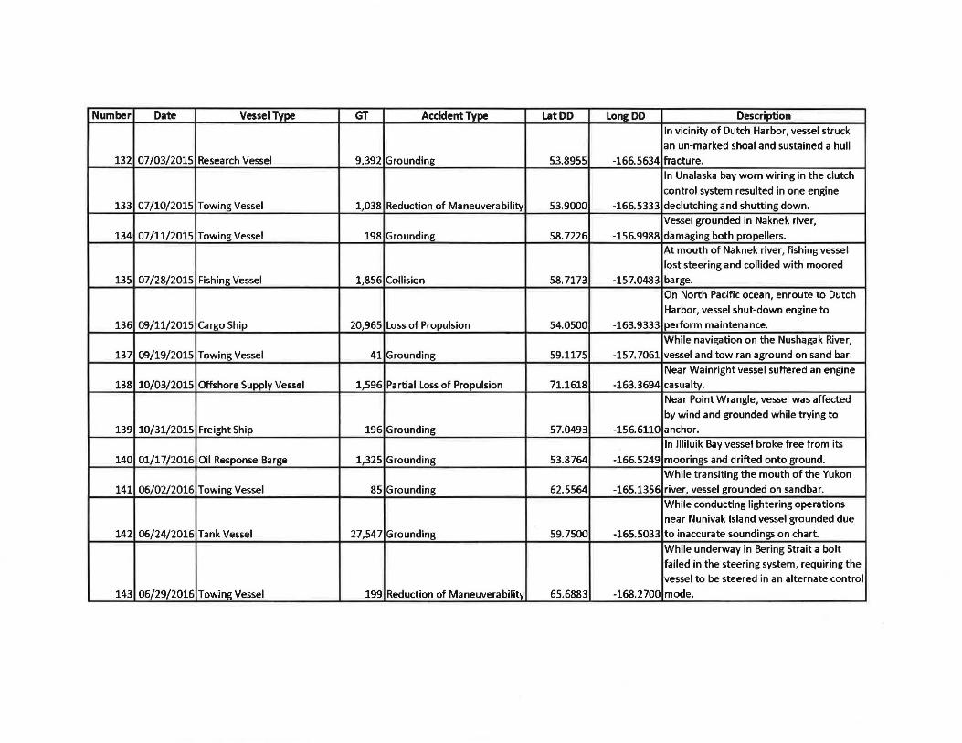
Number Date Vessel Type GT Accident Type Lat DD Long DD Description
In vicinity of Dutch Harbor, vessel struck
an un-marked shoal and sustained a hull 132 07/03/2015 Research Vessel 9,392 Grounding 53.8955 -166.5634 fracture.
In Unalaska bay worn wiring in the clutch
control system resulted in one engine
133 07/10/2015 Towing Vessel 1,038 Reduction of Maneuverability 53.9000 -166.5333 declutching and shutting down.
Vessel grounded in Naknek river,
134 07/11/2015 Towing Vessel 198 Grounding 58.7226 -156.9988 damaging both propellers.
At mouth of Naknek river, fishing vessel
lost steering and collided with moored
135 07/28/2015 Fishing Vessel 1,856 Collision 58.7173 -157.0483 barge.
On North Pacific ocean, enroute to Dutch
Harbor, vessel shut-down engine to
136 09/11/2015 Cargo Ship 20,965 Loss of Propulsion 54.0500 -163.9333 perform maintenance.
While navigation on the Nushagak River,
137 09/19/2015 Towing Vessel 41 Grounding 59.1175 -157. 7061 vessel and tow ran aground on sand bar.
Near Wainright vessel suffered an engine
138 10/03/2015 Offshore Supply Vessel 1,596 Partial Loss of Propulsion 71.1618 -163.3694 casualty.
Near Point Wrangle, vessel was affected
by wind and grounded while trying to
139 10/31/2015 Freight Ship 196 Grounding 57.0493 -156.6110 anchor. In llliluik Bay vessel broke free from its
140 01/17/2016 Oil Response Barge 1,325 Grounding 53.8764 -166.5249 moorings and drifted onto ground.
While transiting the mouth of the Yukon
141 06/02/2016 Towing Vessel 85 Grounding 62.5564 -165.1356 river, vessel grounded on sandbar.
While conducting lightering operations near Nunivak Island vessel grounded due
142 06/24/2016 Tank Vessel 27,547 Grounding 59.7500 -165.5033 to inaccurate soundings on chart.
While underway in Bering Strait a bolt
failed in the steering system, requiring the
vessel to be steered in an alternate control
143 06/29/2016 Towing Vessel 199 Reduction of Maneuverability 65.6883 -168.2700 mode.

Number Date Vessel Type GT Accident Type LatDD Long DD Description While anchored in Captain's Bay, vessel's
anchor failed causing the vessel to ground
on rocks, resulting in the discharge of oily
144 07/06/2016 Recreational Vessel - Equipment Failure 53.8440 -166.5787 bilge wastes.