appendix f description of alternatives and construction ...€¦ · sr 520, medina to sr 202:...
TRANSCRIPT
DECEMBER 2009
SR 520, Medina to SR 202: Eastside Transit and HOV Project
ENVIRONMENTAL ASSESSMENTSR 520 BRIDGE REPLACEMENT AND HOV PROGRAM
Appendix F
Description of Alternatives and Construction Techniques


SR 520, Medina to SR 202:
Eastside Transit and HOV Project Environmental Assessment
Description of Alternatives
and Construction Techniques Discipline Report
Prepared for
Washington State Department of Transportation Federal Highway Administration
Lead Author
HDR Engineering, Inc.
Consultant Team
HDR Engineering, Inc.
Parametrix, Inc.
CH2M HILL
Parsons Brinckerhoff
Michael Minor and Associates
Pacific Rim Resources
November 9, 2009


SR 520, Medina to SR 202: Eastside Transit and HOV Project | Environmental Assessment | Alternatives and Construction Techniques DR
EA_DR_ALTS.DOC iii
Contents Acronyms and Abbreviations ....................................................................................................v Description of Alternatives ........................................................................................................ 1
What is the purpose of the project? ............................................................................... 1 Why do we need the project?.......................................................................................... 1 What led WSDOT to propose the project? .................................................................... 4 How did WSDOT identify the improvements included in the project? ............................................................................................................................... 5 How does the project relate to other projects that are part of the SR 520 Bridge Replacement and HOV Program? .............................................................. 5 What would happen if the project were not built? ...................................................... 6 How has the project involved the public? .................................................................... 6
Alternatives Evaluated ................................................................................................................ 9 What is the Build Alternative? ....................................................................................... 9 What is the No Build Alternative? ............................................................................... 32
Construction Techniques .......................................................................................................... 32 How would the project be constructed and implemented? ..................................... 32 What is the construction schedule?.............................................................................. 33 What methods would likely be used to construct this project? ............................... 33
References and Bibliography ................................................................................................... 39

SR 520, Medina to SR 202: Eastside Transit and HOV Project | Environmental Assessment | Alternatives and Construction Techniques DR
EA_DR_ALTS.DOC iv
Exhibits
1 Project Vicinity
2 Existing and Proposed Traffic Cross Sections
3 Project Features (Plates 1 – 5)
4 Summary of Interchange Improvements – Evergreen Point Road to 108th Avenue NE
5 Evergreen Point Road Interchange
6 84th Avenue NE Interchange
7 92nd Avenue NE Interchange
8 Bellevue Way NE Interchange
9 108th Avenue NE Interchange
10 Eastside Lids
11 Constructed Wetland Facilities
12 Typical Cast in Place Wall
13 Typical MSE Wall
14 Typical Equipment and Use for Roadway and Bridge Construction

SR 520, Medina to SR 202: Eastside Transit and HOV Project | Environmental Assessment | Alternatives and Construction Techniques DR
EA_DR_ALTS.DOC v
Acronyms and Abbreviations AASHTO American Association of State Highway and Transportation Officials
ADA Americans with Disabilities Act
BMPs best management practices
BRT bus rapid transit
DEIS SR 520 Bridge Replacement and HOV Project Draft Environmental Impact Statement
EA Environmental Assessment
EIS environmental impact statement
ESHB Engrossed Substitute House Bill
FHWA Federal Highway Administration
HMA hot mix asphalt
HOV high-occupancy vehicle
MAP Multi-Agency Permitting
MSE mechanically stabilized earth
PGIS pollution-generating impervious surface
PSRC Puget Sound Regional Council
SOV single-occupancy vehicle
SPCC spill prevention control and countermeasures
SR State Route
UPA Urban Partnership Agreement
USDOT U.S. Department of Transportation
USEPA U.S. Environmental Protection Agency
WSDOT Washington State Department of Transportation


SR 520, Medina to SR 202: Eastside Transit and HOV Project | Environmental Assessment | Alternatives and Construction Techniques DR
EA_DR_ALTS.DOC 1
Description of Alternatives
What is the purpose of the project?
The SR 520, Medina to SR 202: Eastside Transit and HOV Project is one of four projects included in the SR 520 Corridor Program. The purpose of the project is to reduce transit and high-occupancy vehicle (HOV) travel times and to enhance travel time reliability, mobility, access, and safety for transit and HOVs in rapidly growing areas along the SR 520 corridor east of Lake Washington. Exhibit 1 shows the project vicinity.
Why do we need the project?
Key reasons that the project is needed include the following:
Support current and planned growth on the Eastside. The population of the Points Communities (Medina, Hunts Point, Clyde Hill, and Yarrow Point), Kirkland, Bellevue, and Redmond is expected to grow by over 77,000 between 2000 and 2030, an approximately 1.0-percent average annual increase (PSRC 2006). Employment in Kirkland, Bellevue, and Redmond is on an even faster growth curve, with a 57-percent increase in jobs projected between 2000 and 2030 (PSRC 2006). Three major redevelopment projects adjacent to SR 520 that are currently in the planning stages are projected to add up to 10,000 new households and up to 12.5 million square feet of office and retail space.
Support transit demand and planned service improvements. Over the last 8 years, transit use on the Eastside has increased by 30 percent. Multiple programs now being planned and implemented will continue to expand transit’s mode share on the Eastside. Improvements funded through King County Metro’s Transit Now program, adopted by voters in 2006, will increase transit service frequency on a portion of SR 520 and many Eastside routes that intersect with SR 520. Seattle’s 2007 Urban Partnership Agreement (UPA) with the U.S. Department of Transportation will fund bus fleet expansion and park-and-ride improvements on the Eastside. The UPA will also impose tolling on single-occupancy vehicles (SOVs) using the corridor in 2009. In addition, the SR 520 High-Capacity Transit Plan—jointly prepared by the Washington

SR 520, Medina to SR 202: Eastside Transit and HOV Project | Environmental Assessment | Alternatives and Construction Techniques DR
EA_DR_ALTS.DOC 2
State Department of Transportation (WSDOT), Metro, Sound Transit, and the University of Washington—identifies SR 520 as a future corridor for bus rapid transit (BRT). All these planned service improvements require the Eastside to have a continuous HOV system that meets current design standards and supports reliable travel times for transit and HOVs.
Facilitate transit reliability and safety. The Eastside is the only portion of SR 520 that has an HOV system. However, this system is discontinuous, offering only westbound HOV options west of I-405. This configuration reflects old commuting patterns, which do not correspond to the commuting patterns of today or those expected in the future. Because of congestion in the general-purpose lanes, the lack of an eastbound HOV lane makes transit times unreliable and offers people no incentive to use transit. The lack of direct access from park-and-ride lots causes the transit system to run inefficiently and creates additional delay for transit riders. In addition, the current configuration of the HOV lanes creates safety hazards due to their location on the outside of the roadway. The outside lanes create conflicts between slow-moving vehicles merging into congested traffic and faster-moving vehicles using the less congested HOV lanes, resulting in accidents and increased congestion.
To support legislative direction linking early SR 520 tolling revenues to improvements on the Eastside. Engrossed Substitute House Bill (ESHB) 2878, passed by the Washington State Legislature in 2008, directs WSDOT to explore the development of improvements in traffic flow on the Eastside during the period of pre-construction tolling on SR 520 (i.e., between the time the UPA tolls are implemented in 2009 and the planned opening of the Evergreen Point Bridge in 2014). These improvements include moving the HOV lanes to the inside of the highway; the bill also urges WSDOT to consider completing the HOV lanes, constructing new transit flyer stops, and building lids to reunite communities separated by SR 520’s original construction in the 1960s. This legislative direction recognizes the fact that Eastside improvements to SR 520 would provide benefit to toll-paying residents and workers even if no improvements are made elsewhere in the corridor.

Medina to SR 202: Eastside Transit and HOV Project
Exhibit 1. Project Vicinity
Source: King County (2005) GIS Data (Streets), KingCounty (2007) GIS Data (Waterbody) and CH2M HILL(2008) GIS Data (Parks and Streams). Horizontal datum forall layers is NAD83(91); vertical datum for layers is NAVD88.
\\SIMBA\PROJ\PARAMETRIX\180171\GIS\MAPFILES\EA\EA\CH1\EA_CH1_VICINITYMAP.MXD 11/5/2009
Lake Washington
UV520
§̈¦5 §̈¦405
UV202
§̈¦405
UV520
UV202
LakeWashington
FairweatherBay
CozyCove
YarrowBay
LakeSammamish
140
TH
AV
E N
E
108
TH
AV
E N
E
132
ND
AV
E N
E
NE 20TH ST
BELLEVUE REDMOND RD
NE 70TH ST
124
TH
AV
E N
E NORTHUP WAY
148
TH
AV
E N
E
BE
LL
EV
UE
WA
Y N
E
112T
H A
VE
NE
NE 24TH ST
NE 85TH ST
92N
D A
VE
NE
84T
H A
VE
NE
EV
ER
GR
EE
N P
OIN
T R
D
R E D M O N D
B E L L E V U E
K I R K L A N D
M E D I N A
C L Y D EH I L L
Y A R R O WP O I N T
H U N T SP O I N T
¯ 0 10.5 Miles
Construction Extent
Restriping Extent
Park
City Limits
AREA OF DETAIL

SR 520, Medina to SR 202: Eastside Transit and HOV Project | Environmental Assessment | Alternatives and Construction Techniques DR
EA_DR_ALTS.DOC 4
What led WSDOT to propose the project?
Some of the improvements included in the proposed SR 520, Medina to SR 202: Eastside Transit and HOV Project were originally part of the SR 520 Bridge Replacement and HOV Project. The environmental process for the SR 520 Bridge Replacement and HOV Project began in 2000 with the issuance of a Notice of Intent to prepare an environmental impact statement (EIS). The original project limits were from I-5 in Seattle to SR 202 in Redmond. However, project funding was eliminated in 2002 and only partially reinstated in 2003. For this reason, the eastern project limit was changed to 108th Avenue NE in Bellevue. WSDOT published the SR 520 Bridge Replacement and HOV Project Draft EIS (DEIS) in August 2006 (WSDOT 2006). The DEIS describes the evaluation of three corridor alternatives: a No Build Alternative, a 4-Lane Alternative (four general-purpose lanes), and a 6-Lane Alternative (four general-purpose plus two HOV lanes).
In late 2006, after considering the findings described in the DEIS, Washington Governor Chris Gregoire identified the 6-Lane Alternative (also known as the “4+2” Alternative) as the State’s preference for moving forward. This preference was endorsed by the Washington State Legislature in 2007. Although within Seattle there remained considerable controversy about the specific configuration of the project, on the Eastside there was relatively widespread public support for the 6-Lane Alternative. Additional legislation passed in 2008 (ESHB 2878) directed WSDOT to study the potential for accelerating improvements on the Eastside. In March 2008, Governor Gregoire highlighted the importance of the SR 520 project to the region and state by announcing an accelerated project schedule. A new floating bridge is now projected to open in 2014, with the full corridor expected to be complete in 2016.
Since the Notice of Intent for the SR 520 corridor was issued in 2000, a number of circumstances have changed. The Eastside has experienced significant economic growth. This growth has substantially increased demand for transit service. Transit agencies are responding with plans for enhanced service. These plans rely on SR 520 to provide the backbone for linking east–west traffic flow from east King County to Seattle and for connections to the north–south corridors along I-5 and I-405. Current transit planning calls for increased service on Eastside

SR 520, Medina to SR 202: Eastside Transit and HOV Project | Environmental Assessment | Alternatives and Construction Techniques DR
EA_DR_ALTS.DOC 5
routes, including two major bus rapid transit routes on or near the SR 520 corridor.
On June 18, 2008, the Federal Highway Administration (FHWA) authorized WSDOT to develop the SR 520, Medina to SR 202: Eastside Transit and HOV Project as an independent project. The project includes a study area from approximately Evergreen Point Road in Medina east along SR 520 to SR 202 in Redmond.
How did WSDOT identify the improvements included in the project?
The project would complete the eastbound HOV system from Evergreen Point Road (near the Lake Washington shoreline) to the interchange with SR 202 (at the east end of SR 520), a distance of approximately 8.8 miles. The project has been designed with these priorities in mind:
Improving transit and HOV travel times.
Enhancing travel time reliability, mobility, and access for transit and HOVs.
Supporting transit demand and planned service improvements.
Improving traffic safety in the SR 520 corridor.
Supporting current and planned growth east of Lake Washington.
Improving transit reliability and safety along the SR 520 corridor by shifting the HOV lanes to the inside of the freeway and providing direct access to these lanes at five key interchanges.
How does the project relate to other projects that are part of the SR 520 Bridge Replacement and HOV Program?
WSDOT proposes to construct the project as one of four projects related to SR 520. Each project will undergo independent environmental review. Once completed, the project would be compatible with the three other projects planned for the SR 520 Bridge Replacement and HOV Program:

SR 520, Medina to SR 202: Eastside Transit and HOV Project | Environmental Assessment | Alternatives and Construction Techniques DR
EA_DR_ALTS.DOC 6
I-5 to Medina: Bridge Replacement and HOV Project. This project involves improvements to the Evergreen Point Bridge and Westside corridor and approaches on both sides of Lake Washington.
Pontoon Construction Project. This project includes construction and storage of the pontoons that would be used in the event of a catastrophic failure of the existing Evergreen Point Bridge.
Lake Washington Urban Partnership. This project addresses implementation of electronic tolling to manage congestion along the SR 520 corridor. Tolling is not considered part of the Medina to SR 202: Eastside Transit and HOV Project.
What would happen if the project were not built?
If the project were not built, transit and HOV travel times would not improve and improved infrastructure would not be in place to support planned service improvements. At the rate population is growing in the area, the morning and evening commutes would become slower for even longer portions of the day, and transit reliability would continue to worsen.
Other project benefits would not be realized if the project were not built. These other benefits include removing fish passage barriers, enhancing streams, improving trails, constructing noise walls, and providing lids at key locations to reconnect the communities separated by SR 520 when the highway was originally constructed in the 1960s.
How has the project involved the public?
In accordance with the project’s Public Involvement Plan, WSDOT has involved the public in the project through a wide range of activities, such as the following:
Developed a project e-mail list and distributed a monthly e-newsletter. As of October 2008, the project e-mail list had approximately 9,900 contacts.
Invited citizens to participate in the project scoping and development process. The project team hosted a public scoping
For more information regarding public involvement and agency coordination, please see the Agency Coordination and Public Involvement Discipline Report.

SR 520, Medina to SR 202: Eastside Transit and HOV Project | Environmental Assessment | Alternatives and Construction Techniques DR
EA_DR_ALTS.DOC 7
meeting to introduce the project on Tuesday, September 23, 2008. A total of 59 people attended the meeting per the sign-in sheets. As of November 12, 2008, WSDOT had received written responses from six entities (cities of Kirkland, Bellevue, Redmond, and Medina; the U.S. Department of the Interior; U.S. Fish and Wildlife Service) and one tribal nation (Muckleshoot Indian Tribe).
The meeting’s format was an open house. WSDOT used several methods of notification to solicit comments during the scoping period and to encourage attendance at the public scoping meeting. These notification methods are listed below.
o Meeting postcards.
o Display ads.
o Legal notices.
o Online notices.
o E-mail announcements.
o Notification postcards to transit commuters.
o Community outreach and events.
o Eastside community design collaboration workshops.
o Press release (local and regional media).
o Community and jurisdictional briefings.
o Providing project information in multiple languages and in easily accessible locations such as public libraries.
Relying on the approach for the SR 520 Bridge Replacement and HOV Project DEIS, the project team analyzed census and demographic data to determine which under-represented communities are inside or near the project corridor. These data will be supplemented by interviews with a number of social service agencies that serve minority, limited English proficiency, and low-income populations.
Commenting on the SR 520, Medina to SR 202: Eastside Transit and HOV Project Environmental Assessment (EA) is also a very important way for the public to participate in the process. WSDOT will reach out to all potentially affected members of the public, including low-income and minority populations and those with limited English proficiency.

SR 520, Medina to SR 202: Eastside Transit and HOV Project | Environmental Assessment | Alternatives and Construction Techniques DR
EA_DR_ALTS.DOC 8
After WSDOT publishes the EA, a public hearing will be held to gather comments on the results of the evaluation and proposed mitigation measures.
How has WSDOT involved government agencies?
WSDOT coordinated with FHWA, the co-lead agency.
WSDOT will involve federal, state, and local agencies that participate in the review process for the EA, anticipated to include the following:
U.S. Environmental Protection Agency (USEPA), U.S. Army Corps of Engineers, and the U.S. Department of the Interior.
Puget Sound Clean Air Agency and Puget Sound Regional Council.
City of Seattle, City of Mercer Island, City of Medina, Town of Hunts Point, City of Clyde Hill, Town of Yarrow Point, City of Kirkland, City of Bellevue, City of Redmond, King County.
Agencies were also involved in the following ways:
Congressional and legislative briefings.
Meetings with resource agencies.
Briefings and site visits with the Multi-Agency Permitting (MAP) team. The Map team includes employees from five separate federal (U.S. Army Corps of Engineers), state (WSDOT, Washington State Department of Ecology, Washington Department of Fish and Wildlife), and local agencies (King County).
Coordination meetings with local municipalities.
How has WSDOT involved tribal governments?
In accordance with Section 106 of the National Historic Preservation Act, WSDOT consults with the following federally recognized tribes: The Muckleshoot Indian Tribe, the Yakama Nation, the Snoqualmie Tribe, the Tulalip Tribes, and the Suquamish Tribe. WSDOT is also coordinating with the Duwamish Tribe, a non-federally recognized tribe, as a consulting party.
Tribal governments help WSDOT identify social, cultural, environmental, and other issues of concern to tribal members. In accordance with WSDOT Executive Order E1025.00 (February 19, 2003), WSDOT commits itself to respectful, effective consultation and

SR 520, Medina to SR 202: Eastside Transit and HOV Project | Environmental Assessment | Alternatives and Construction Techniques DR
EA_DR_ALTS.DOC 9
communication with tribal governments, recognizing that project activities could affect tribal rights and interests.
Alternatives Evaluated This section describes how the project alternatives were developed and considered for analysis. Effects of the alternatives are not included.
The EA considers the following two alternatives:
Build Alternative
No Build Alternative
Each of these alternatives is described in detail below.
What is the Build Alternative?
Under the Build Alternative, the proposed project would include the following elements:
Completing the eastbound SR 520 HOV lane from Lake Washington to the existing eastbound HOV lane west of the I-405 interchange (approximately 2.6 miles). This improvement would complete the currently discontinuous HOV network on the Eastside and improve travel time reliability for buses and carpools.
Restriping HOV lanes from the outside lanes to the inside lanes from Lake Washington to SR 202 (approximately 6.2 miles). This change would enhance safety by eliminating the need for merging vehicles to weave across the faster-moving HOV lanes to reach the general-purpose lanes.
Building inside transit stops at 92nd Avenue NE and just east of Evergreen Point Road. These transit stops would support the inside HOV lanes. Access would be integrated with the proposed lids over the highway.
Adding a regional bicycle/pedestrian path between 108th Avenue NE and Evergreen Point Road. This would facilitate non-motorized use of SR 520, provide transit connections for bicycles and pedestrians, and complement the existing non-motorized transportation network on the Eastside.
SR 520, Medina to SR 202: Eastside Transit and HOV Project | Environmental Assessment | Alternatives and Construction Techniques DR
EA_DR_ALTS.DOC 10
Constructing HOV direct access ramps at 108th Avenue NE; this improvement would connect SR 520 with 108th Avenue NE. The HOV and transit traffic would merge directly into the inside HOV lane. This condition is expected to improve travel time, trip reliability, and safety for HOV and transit in the corridor.
Rebuilding interchanges at 84th Avenue NE, 92nd Avenue NE, Bellevue Way NE, and 108th Avenue NE by redesigning ramps to improve freeway access and traffic operation.
Providing noise walls between Evergreen Point Road and Bellevue Way NE to reduce current and future high levels of highway noise.
Constructing a stormwater management system for areas where new impervious surface is added to improve water quality and reduce peak flows.
Building lids at Evergreen Point Road, 84th Avenue NE, and 92nd Avenue NE to reconnect communities divided by the original construction of SR 520 in the 1960s.
Improving and enhancing stream habitat by making culverts fish-passable and realigning Yarrow Creek, a salmon-bearing stream.
The proposed improvements to the Eastside portion of SR 520 would not preclude any reasonably foreseeable improvements under consideration for other portions of SR 520 or connecting transportation facilities. The HOV lanes would tie-in prior to the Evergreen Point Bridge at the proposed west terminus of the project; that is, the lanes would taper back to the existing roadway between Evergreen Point Road and the approach to the Evergreen Point Bridge. This roadway configuration would be compatible with any of the bridge replacement alternatives described in the SR 520 Bridge Replacement and HOV Project Draft Environmental Impact Statement, including the No Build Alternative. At the east end of the SR 520 corridor in Redmond, the proposed restriping of HOV lanes would be compatible with the current project to widen SR 520 and SR 202. The SR 520, Medina to SR 202: Eastside Transit and HOV Project would also not affect planned future improvements to I-405 in the area of the I-405/SR 520 interchange.

SR 520, Medina to SR 202: Eastside Transit and HOV Project | Environmental Assessment | Alternatives and Construction Techniques DR
EA_DR_ALTS.DOC 11
What environmental issues influenced project design?
WSDOT actively pursues ways to protect and preserve important natural resources and the integrity of neighborhoods. The project team planned for several environmental issues, including the following:
Streams
Wetlands
Land Use and Relocations
Visual Quality and Aesthetics
Water Resources
Parks
In response to the project team’s evaluation of environmental issues, WSDOT intends to avoid or minimize potential negative effects of the project by incorporating specific design features.
How would this project incorporate community design preferences?
WSDOT has worked with the affected cities within the SR 520 corridor to develop visual guidelines that establish the community design preferences used to design the project features. These guidelines have been incorporated into the Urban Design Criteria adopted by WSDOT. The proposed project is being planned, developed, and designed according to these guidelines.
WSDOT also formed the Eastside community design collaboration with elected officials and staff of local communities on the Eastside. Members were asked to select preferred packages of design concepts or “palettes” for aesthetic treatments that would define lid character, transit stop environments, and wall treatments along the Eastside SR 520 corridor.
What are the project’s design elements?
Construction along the Eastside corridor would occur from just west of Evergreen Point Road to just east of 108th Avenue NE, a distance of about 2.6 miles. From I-405 to SR 202 (about 6.2 miles), no construction would occur; improvements would be limited to restriping to shift the HOV lanes to the inside and placing new signs.

SR 520, Medina to SR 202: Eastside Transit and HOV Project | Environmental Assessment | Alternatives and Construction Techniques DR
EA_DR_ALTS.DOC 12
The Build Alternative would provide six lanes (four general-purpose and two HOV) from just west of Evergreen Point Road to SR 202. New construction between Evergreen Point Road and I-405 would add a new eastbound HOV lane to connect with the existing HOV lane and provide standard 10-foot-wide shoulders, both eastbound and westbound. The project would also rebuild or improve the existing interchanges and crossings from Evergreen Point Road to 108th Avenue NE. The existing Evergreen Point Bridge would function as it does today. The east approach would be widened just west of Evergreen Point Road and tapered back to the existing roadway before the Evergreen Point Bridge. Exhibit 2 shows the existing and proposed traffic cross sections. Exhibit 3, Plates 1–5, shows the project design features and footprint.
Exhibit 2. Existing and Proposed Traffic Cross Sections

Medina to SR 202: Eastside Transit and HOV Project
Exhibit 3. Project FeaturesPlate
Source: City of Bellevue (1999) GIS Data (City Limits), KingCounty (2006) Aerial Photo, and CH2M HILL (2008) GISData (Park and Stream). Horizontal datum for all layers isNAD83(91); vertical datum for layers is NAVD88.
HU
NT
S P
OIN
T
ME
DIN
A
Evergreen Point Roadwill be rebuilt aspart of the new lid
RegionalBicycle/Pedestrian
PathPoints
LoopTrail
Pedestrian overcrossing will be removed
New lanes taperback to existingroadway
Expanded Park & Ride
Swale
Walkway and bridge to transit platform
FairweatherPark
LakeWashington
Fairweather Bay
Unnamed Tributary to Fairweather Bay
Fairweather Bay Creek
EV
ER
GR
EE
N P
OIN
T R
D
NE 31ST ST
80TH
AV
E N
E
NE 28TH PL
82ND
AV
E N
E
77TH
AV
E N
E
NE 28TH ST
78TH
AV
E N
E
FAIR
WE
AT
HE
R P
L
79TH
AV
E N
E
78TH
PL N
E
NE 27TH ST
NE 32ND ST
Proposed Stream Channel
Proposed Fish Passable Culvert
Existing Fish Passable Culvert
Proposed Noise Wall
Transit Stop
Lid
Park
Regional Bicycle/Pedestrian Path
Points Loop Trail
General-Purpose Lane
HOV/Transit Lane
Stormwater Feature
¯ 0 200 400100 Feet
Lake Washington
UV520
§̈¦405
51
432
\\SIMBA\PROJ\PARAMETRIX\180171\GIS\MAPFILES\EA\ALTERNATIVEDESCRIPTION\EA_DR_ALT_PROJECTFEATURES.MXD 11/5/2009
1
AREA OF DETAIL

Medina to SR 202: Eastside Transit and HOV Project
Exhibit 3. Project FeaturesPlate
Source: City of Bellevue (1999) GIS Data (City Limits), KingCounty (2006) Aerial Photo, and CH2M HILL (2008) GISData (Park and Stream). Horizontal datum for all layers isNAD83(91); vertical datum for layers is NAVD88.
MED
INA
CLY
DE
HIL
L
YAR
RO
W P
OIN
T
HU
NTS
PO
INT
Interchange will be rebuiltas a half-diamond interchange
84th Ave NE will be rebuiltas part of the new lid
Loop ramp will be removedand replaced with greenspace as part of the new lid
Regional Bicycle/Pedestrian Path
Hunts Point Park
WetherillNature
Preserve
Fairweather Bay Creek
Cozy Cove Creek
NE 32ND ST
84T
H AV
E N
E
NE 32ND ST
NE 31ST ST
88T
H AV
E N
E
FAIR
WE
ATH
ER
PL
HU
NTS POINT
CIR
HU
NT
S P
OIN
T R
D
NE 30TH ST
92ND
PL
N
ENE 28TH ST
MEDINA CIR
HUNTS POINT LN
Proposed Stream Channel
Proposed Fish Passable Culvert
Existing Fish Passable Culvert
Proposed Noise Wall
Transit Stop
Lid
Park
Regional Bicycle/Pedestrian Path
Points Loop Trail
General-Purpose Lane
HOV/Transit Lane
Stormwater Feature
¯ 0 200 400100 Feet
Lake Washington
UV520
§̈¦405
51
432
\\SIMBA\PROJ\PARAMETRIX\180171\GIS\MAPFILES\EA\ALTERNATIVEDESCRIPTION\EA_DR_ALT_PROJECTFEATURES.MXD 11/5/2009
2
AREA OF DETAIL

Medina to SR 202: Eastside Transit and HOV Project
Exhibit 3. Project FeaturesPlate
Source: City of Bellevue (1999) GIS Data (City Limits), KingCounty (2006) Aerial Photo, and CH2M HILL (2008) GISData (Park and Stream). Horizontal datum for all layers isNAD83(91); vertical datum for layers is NAVD88.
YARROW POINT
CLYDE HILL
KIR
KLA
ND
YAR
RO
W P
OIN
T
CLY
DE
HIL
LB
ELLE
VU
E
92nd Ave NERebuilt as part
of new lid
New PointsLoop TrailExtension
92nd Ave NE interchangewill be rebuilt as a half-diamond interchange
Transit stops will belocated adjacent to the92nd Ave NE lid
Regional Bicycle/Pedestrian Path
Points Loop Trail
Roundabout
Stormwatertreatment
vault
YarrowBay
Wetlands
Tributary to Yarrow Bay Wetlands
NE 33RD ST
POINTS
DR N
E
92N
D AV
E N
E
97T
H AV
E N
E
95TH
PL
NE
NE 36TH ST
92N
D AV
E N
E
NE 31ST ST
NE 32ND ST
NE 33RD ST
96TH
AVE
NE
NE 34TH ST
NE 34TH ST
NE 35TH ST
Proposed Stream Channel
Proposed Fish Passable Culvert
Existing Fish Passable Culvert
Proposed Noise Wall
Transit Stop
Lid
Park
Regional Bicycle/Pedestrian Path
Points Loop Trail
General-Purpose Lane
HOV/Transit Lane
Stormwater Feature
¯ 0 200 400100 Feet
Lake Washington
UV520
§̈¦405
51
432
\\SIMBA\PROJ\PARAMETRIX\180171\GIS\MAPFILES\EA\ALTERNATIVEDESCRIPTION\EA_DR_ALT_PROJECTFEATURES.MXD 11/5/2009
3
AREA OF DETAIL

Medina to SR 202: Eastside Transit and HOV Project
Exhibit 3. Project FeaturesPlate
Source: City of Bellevue (1999) GIS Data (City Limits), KingCounty (2006) Aerial Photo, and CH2M HILL (2008) GISData (Park and Stream). Horizontal datum for all layers isNAD83(91); vertical datum for layers is NAVD88.
CLY
DE
HIL
L
BEL
LEV
UE
KIRKLAND
BELLEVUE
BELLEVUEKIRKLAND
Bellevue Wayinterchangerebuilt as a
half-diamondinterchange
Loop ramp willbe removed
Loop ramp tobe removed
YarrowBay
Wetlands
Yarrow Creek
West Tributary to Yarrow Creek
EastTributary to Yarrow C
reek
NE LAKE WASHINGTON BLVD
100TH LN
NE
NE 34TH ST
NORTHUP WAY
101ST WAY NE
99TH
AVE
NE
BELLEVUE
WAY
NE
NE 35TH
ST
103RD AVE NE
102ND AVE NE
POINTS DR NE
Proposed Stream Channel
Proposed Fish Passable Culvert
Existing Fish Passable Culvert
Proposed Noise Wall
Transit Stop
Lid
Park
Regional Bicycle/Pedestrian Path
Points Loop Trail
General-Purpose Lane
HOV/Transit Lane
Stormwater Feature
¯ 0 200 400100 Feet
Lake Washington
UV520
§̈¦405
51
432
\\SIMBA\PROJ\PARAMETRIX\180171\GIS\MAPFILES\EA\ALTERNATIVEDESCRIPTION\EA_DR_ALT_PROJECTFEATURES.MXD 11/5/2009
4
AREA OF DETAIL

Medina to SR 202: Eastside Transit and HOV Project
Exhibit 3. Project FeaturesPlate
Source: City of Bellevue (1999) GIS Data (City Limits), KingCounty (2006) Aerial Photo, and CH2M HILL (2008) GISData (Park and Stream). Horizontal datum for all layers isNAD83(91); vertical datum for layers is NAVD88.
BELL
EVU
E
KIRK
LAND
108th Ave NE interchangewill be rebuilt with minorchanges to ramp geometry
Begin restripeto SR 202
Transit and HOV DirectAccess Ramp
South Kirkland Park & Ride
EastTributary to Yarrow Creek
Yarrow Creek
South Fork Yarrow Creek
108TH
AV
E N
E
110TH AVE NE
BELLEVUE WAY NE
108TH PL NE
NE 35TH PL
116TH PL NE
NE 34TH PL
NE 30TH ST
NORTHUP WAY
NORTHUP WAY
NE 33RD PL
112TH AVE NE
Proposed Stream Channel
Proposed Fish Passable Culvert
Existing Fish Passable Culvert
Proposed Noise Wall
Transit Stop
Lid
Park
Regional Bicycle/Pedestrian Path
Points Loop Trail
General-Purpose Lane
HOV/Transit Lane
Stormwater Feature
¯ 0 200 400100 Feet
Lake Washington
UV520
§̈¦405
51
432
\\SIMBA\PROJ\PARAMETRIX\180171\GIS\MAPFILES\EA\ALTERNATIVEDESCRIPTION\EA_DR_ALT_PROJECTFEATURES.MXD 11/5/2009
5
AREA OF DETAIL
SR 520, Medina to SR 202: Eastside Transit and HOV Project | Environmental Assessment | Alternatives and Construction Techniques DR
EA_DR_ALTS.DOC 18
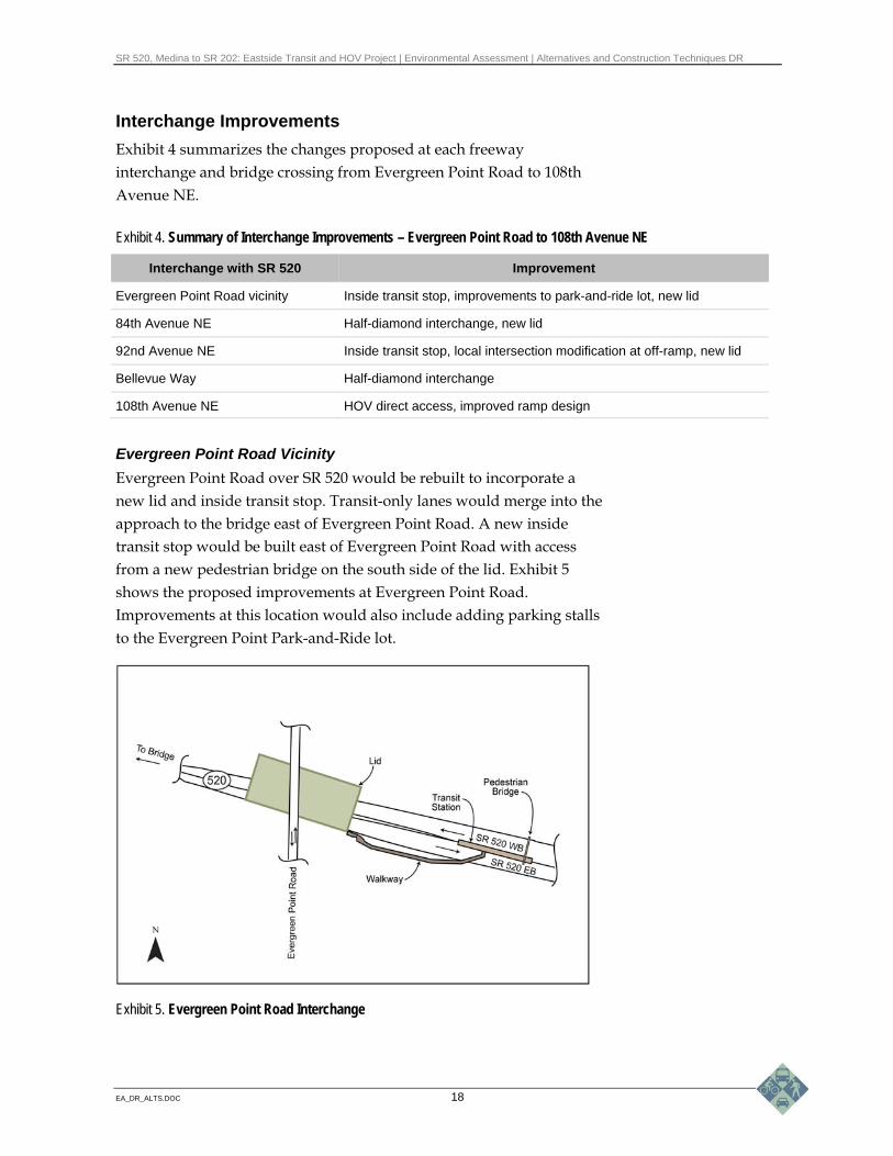
Interchange Improvements
Exhibit 4 summarizes the changes proposed at each freeway interchange and bridge crossing from Evergreen Point Road to 108th Avenue NE.
Exhibit 4. Summary of Interchange Improvements – Evergreen Point Road to 108th Avenue NE
Interchange with SR 520 Improvement
Evergreen Point Road vicinity Inside transit stop, improvements to park-and-ride lot, new lid
84th Avenue NE Half-diamond interchange, new lid
92nd Avenue NE Inside transit stop, local intersection modification at off-ramp, new lid
Bellevue Way Half-diamond interchange
108th Avenue NE HOV direct access, improved ramp design
Evergreen Point Road Vicinity
Evergreen Point Road over SR 520 would be rebuilt to incorporate a new lid and inside transit stop. Transit-only lanes would merge into the approach to the bridge east of Evergreen Point Road. A new inside transit stop would be built east of Evergreen Point Road with access from a new pedestrian bridge on the south side of the lid. Exhibit 5 shows the proposed improvements at Evergreen Point Road. Improvements at this location would also include adding parking stalls to the Evergreen Point Park-and-Ride lot.
Exhibit 5. Evergreen Point Road Interchange

SR 520, Medina to SR 202: Eastside Transit and HOV Project | Environmental Assessment | Alternatives and Construction Techniques DR
EA_DR_ALTS.DOC 19
The existing pedestrian crossing located east of the Evergreen Point Road interchange would be removed. Pedestrian access north and south across SR 520 would be accommodated by the new lid at Evergreen Point Road or the lid farther east at 84th Avenue NE.
84th Avenue NE Interchange
The 84th Avenue NE interchange would be reconfigured as a half-diamond interchange with a new lid (Exhibit 6). The on-ramps and off-ramps of the half-diamond interchange would be constructed on the west side of 84th Avenue NE. The westbound on-ramp would be built with one general-purpose lane and one HOV bypass lane and would include a ramp meter signal. The eastbound off-ramp would consist of one lane that would exit from SR 520 eastbound, becoming two lanes at the 84th Avenue NE intersection with an exclusive right-turn lane. The loop on-ramp in the northeast quadrant of the interchange would be removed and replaced with green space to connect the lid with Hunts Point (D.K. MacDonald) Park. The lid would carry 84th Avenue NE over SR 520. The configuration of 84th Avenue NE over the lid would consist of a single southbound lane, a northbound lane, and a northbound left-turn lane for vehicles traveling westbound on SR 520.
Exhibit 6. 84th Avenue NE Interchange
What is a half-diamond interchange?
In a half-diamond interchange, traffic exits or enters the freeway in one direction. This creates a triangular or half-diamond configuration as shown below.

SR 520, Medina to SR 202: Eastside Transit and HOV Project | Environmental Assessment | Alternatives and Construction Techniques DR
EA_DR_ALTS.DOC 20
92nd Avenue NE Interchange
The 92nd Avenue NE interchange would be configured similarly to the half-diamond interchange that exists today (Exhibit 7). The on-ramps and off-ramps of the half-diamond interchange would be located on the east side of 92nd Avenue NE. The eastbound on-ramp would be rebuilt with one general-purpose lane and one HOV bypass lane and would include a ramp meter signal. The SR 520 westbound off-ramp would be rebuilt with one general-purpose lane and would include a new roundabout at the end of the ramp. Transit stops would be located in the center of SR 520 west of the 92nd Avenue NE lid for buses traveling both eastbound and westbound.
Bellevue Way NE Interchange
The Bellevue Way NE interchange would be reconfigured to a half-diamond interchange (Exhibit 8). The on-ramps and off-ramps of the half-diamond interchange would be located on the west side of Bellevue Way NE. The westbound on-ramp would consist of three westbound lanes—two general-purpose lanes and one HOV bypass lane—and would include a ramp meter signal. The eastbound off-ramp would consist of one lane that would exit from SR 520 eastbound, becoming three lanes at the Bellevue Way NE intersection (two lanes turning left toward Kirkland and one lane turning right toward Bellevue).
Exhibit 7. 92nd Avenue NE Interchange

SR 520, Medina to SR 202: Eastside Transit and HOV Project | Environmental Assessment | Alternatives and Construction Techniques DR
EA_DR_ALTS.DOC 21
The existing loop ramps on the east side of Bellevue Way NE would be removed to enhance Yarrow Creek and provide space for stormwater facilities.
Exhibit 8. Bellevue Way NE Interchange
The Bellevue Way NE bridge over SR 520 would be widened to provide landscaping on either side and a shared use path on the east side. The configuration of Bellevue Way NE over SR 520 would consist of two southbound and northbound lanes that would pass through signalized intersections, plus turn lanes at eastbound and westbound ramp terminals. A northbound left-turn lane would extend beyond the south traffic signal for vehicles traveling westbound on SR 520.
The westbound leg of the Bellevue Way NE/Northrup Way intersection would be reconfigured to include a double left-turn lane. The south leg of the intersection would include a southbound HOV bypass lane for westbound HOV traffic.
108th Avenue NE Interchange
The 108th Avenue NE interchange would be constructed to include HOV direct access ramps to 108th Avenue NE to improve HOV connections for travel to and from Kirkland and Bellevue (Exhibit 9). The HOV direct access ramps would allow HOV vehicles to exit onto 108th Avenue NE from eastbound SR 520 and to enter westbound SR 520 from 108th Avenue NE.

SR 520, Medina to SR 202: Eastside Transit and HOV Project | Environmental Assessment | Alternatives and Construction Techniques DR
EA_DR_ALTS.DOC 22
The 108th Avenue NE interchange westbound on-ramp would be rebuilt to include a ramp meter signal for general-purpose traffic and traffic traveling northbound on 108th would no longer be able to turn left onto this ramp. The end of the westbound SR 520 off-ramp would be relocated to the south to create a new intersection with the SR 520 HOV direct access ramps. The eastbound SR 520 on-ramp configuration would be similar to today and its intersection with 108th Avenue NE would have a traffic signal.
Exhibit 9. 108th Avenue NE Interchange

SR 520, Medina to SR 202: Eastside Transit and HOV Project | Environmental Assessment | Alternatives and Construction Techniques DR
EA_DR_ALTS.DOC 23
Lid Designs
As described above, lids would be constructed at Evergreen Point Road, 84th Avenue NE, and 92nd Avenue NE. The lids would carry the existing local streets over SR 520 and would provide new landscaped open space for passive recreation that would reconnect communities on the north and south sides of SR 520. Exhibit 10 shows conceptual drawings of potential design features of lids.
Evergreen Point Road Lid
For the Evergreen Point lid in Medina, WSDOT proposes a lid that would include a bus transit stop to the east of the lid, a park-and-ride lot with passenger drop-off at the south edge of a transit plaza, a defined area for a Lake Washington scenic overlook, and a new entrance to Fairweather Park on the north side of SR 520. The transit plaza would be located east of the lid. Passengers would be able to access the transit platforms via a walkway leading from the park-and-ride. The walkway would cross over the eastbound lanes to end in the median. At the end of the walkway, elevator or stairs will be designed to comply with Americans with Disabilities Act (ADA) standards and would allow passengers to access the transit platforms.
The lid surface would be landscaped to promote visibility between the park, regional bicycle/pedestrian path, transit plaza, parking area, and the Lake Washington scenic overlook. Other amenities that could be provided include bicycle lockers and/or racks, plaza seating, illumination, and a gathering area for the overlook with seating.
84th Avenue NE Lid
WSDOT proposes a lid that would be landscaped with recreational walking paths connected to the Hunts Point Park and Town Hall, and to the Points Loop Trail. Reconfiguring the existing westbound on-ramps would provide an opportunity to create a landscaped open space adjacent to the Town Hall and the park.

\\simba\proj\Parametrix\180171\GRAPHICS\x_EA_Eastside\ALTS\EA_ALTS_DR_Ex10_EastsideLids_Final_05nov09.ai
Exhibit 10. Eastside Lids Medina to SR 202: Eastside Transit and HOV Project
§̈¦405
UV520
Lake Washington
AREA OF DETAIL
EPR84th
92nd
84th Avenue NE
Evergreen Point Road
92nd Avenue NE

SR 520, Medina to SR 202: Eastside Transit and HOV Project | Environmental Assessment | Alternatives and Construction Techniques DR
EA_DR_ALTS.DOC 25
92nd Avenue NE Lid
WSDOT proposes a lid that would include a bus transit stop with a transit plaza and a passenger drop-off loop on the lid and transit platforms at the highway level. The transit plaza and passenger drop-off loop would be located on the west half of the lid. Passengers would be able to connect to the transit platforms by elevator or stairs, which would be designed to comply with ADA standards.
The lid surface would be landscaped to optimize visibility between the regional bicycle/pedestrian path and the transit plaza. Other amenities that could be provided include bicycle lockers, plaza seating, and illumination. The 92nd Avenue NE lid would also have a pedestrian bridge spanning the eastbound on-ramp to connect the regional bicycle/pedestrian path to a proposed recreational path on the south side of SR 520.
Regional Bicycle/Pedestrian Path
WSDOT would construct the regional bicycle/pedestrian path on the north side of SR 520 to provide a continuous, nonstop route between 108th Avenue NE on the east and the Evergreen Point Bridge on the west. The regional path would be 14 feet wide, have grades no greater than 5 percent, and meet American Association of State Highway and Transportation Officials (AASHTO) standards.
The existing Points Loop Trail would remain on the south side of SR 520 for local pedestrian and recreational use only. Several sections of the trail would be relocated to the north and rebuilt to accommodate the regional path, but would follow the original alignment as closely as possible. The existing pedestrian overpass just east of Evergreen Point Road would be removed. Pedestrian access across SR 520 would be replaced by the new lid at Evergreen Point Road and the new lid at 84th Avenue NE.
Because of the steep terrain, the regional bicycle/pedestrian path and Points Loop Trail would be at different elevations. Support walls would be required to keep the regional path slope at less than a 5-percent grade, per AASHTO standards. Railings would be installed where there was a drop-off greater than 36 inches. Noise walls could be installed between the regional path and the roadway in some places.

SR 520, Medina to SR 202: Eastside Transit and HOV Project | Environmental Assessment | Alternatives and Construction Techniques DR
EA_DR_ALTS.DOC 26
Restriping Work
Between 108th Avenue NE and SR 202 (approximately 6.2 miles), the eastbound and westbound lanes would be restriped to shift the HOV lane from the outside lane to the inside lane. The work would also include moving the existing HOV signs on the outside to the inside or, in some cases, replacing them with new signs.
Illumination
The study area contains illumination only at interchanges. The existing lighting design does not meet current WSDOT standards. As part of the proposed project, continuous lighting would be provided along the mainline of SR 520 and lids. This means that light poles would be placed along the entire project area to provide lighting coverage for the freeway. The lighting will be designed to minimize potential light spillage onto adjacent properties by using shields around the top of the light fixtures that will direct light toward the roadway. These shields would be very similar to those already in use on the existing Evergreen Point Bridge.
How will this project incorporate community design preferences?
WSDOT has worked with the affected cities and towns within the SR 520 corridor to develop visual guidelines that establish the community design preferences used to design the project features. These guidelines have been incorporated into the Urban Design Process guidelines adopted by WSDOT. The proposed project is being planned, developed, and designed according to these guidelines.
WSDOT also formed the Eastside community design collaboration with elected officials and staff of local communities on the Eastside. Members were asked to indicate preferred packages of design concepts of “palettes” for aesthetic treatments that would define the lid character, transit stop environments, and wall treatments along the Eastside SR 520 corridor. Please see the Visual Quality and Aesthetics Technical Memorandum (WSDOT 2009c) for more detail on how input from the design collaboration was incorporated into the design of the project.

SR 520, Medina to SR 202: Eastside Transit and HOV Project | Environmental Assessment | Alternatives and Construction Techniques DR
EA_DR_ALTS.DOC 27
How would stormwater be managed?
Stormwater flow control and stormwater quality treatment within WSDOT-owned right of way is determined by requirements of the Highway Runoff Manual (WSDOT 2008d). Stormwater flow control and stormwater quality treatment outside of WSDOT-owned right of way is determined by local jurisdictions’ stormwater plans. Both basic and enhanced stormwater treatment best management practices (BMPs) would be used. Basic stormwater treatment BMPs will be used for city-owned streets, and enhanced stormwater treatment BMPs will be used for WSDOT-owned roadway runoff. The amount of BMPs to be used is determined by surface area of impervious surfaces (defined as acres). Impervious surface quantities are used to then determine the size of the stormwater facilities. The sizes of the facilities are usually discussed in terms of the volume of runoff they hold (in acre-feet).
The project vicinity is subdivided into four basins for stormwater management. The first basin, Lake Washington, covers from the western limits of the project to approximately Evergreen Point Road; the second basin is Fairweather Creek (from Evergreen Point Road to just east of 84th Avenue NE); the third is Cozy Cove Creek (from 84th Avenue NE to just east of 92nd Avenue NE); and the fourth basin is the Yarrow Creek basin (from just east of 92nd Avenue NE to just east of 108th Avenue NE).
The area from the approach of the Evergreen Point Bridge to Evergreen Point Road (approximately 1.4 acres of impervious surface) would be treated for water quality by the use of a biofiltration swale. The biofiltration swale would be constructed within existing right of way and would directly discharge treated stormwater into Lake Washington under the existing Evergreen Point Bridge (see Plate 1 of Exhibit 3 for location).
Stormwater collected within the Fairweather/Cozy Cove Creek basins (approximately 27.7 acres of impervious surface) would be collected and conveyed to two constructed wetland facilities (see Exhibit 11) that would provide enhanced water quality treatment. Both of these facilities would discharge directly into Fairweather Bay.
The Yarrow Creek basin is the largest basin in the study area. The project proposes to treat approximately 333 acres in pollution-generating impervious surface (PGIS) within this basin. Stormwater would be treated for water quality onsite. Stormwater detention would
What is a biofiltration swale?
A biofiltration swale provides basic treatment and consists of a flat-bottomed, shallow-sloped swale planted with grasses. The swale functions by slowing runoff velocities, filtering out sediment and other pollutants, and providing some infiltration into underlying soils.

SR 520, Medina to SR 202: Eastside Transit and HOV Project | Environmental Assessment | Alternatives and Construction Techniques DR
EA_DR_ALTS.DOC 28
occur both onsite and offsite at a location or locations yet to be determined. For more information on water quality and quantity treatment, please see the Water Resources Discipline Report (WSDOT 2009d).
In accordance with the Highway Runoff Manual (WSDOT 2008d), the project team modeled the pre-developed condition for stormwater detention facilities as forested till and attempted to design detention facilities to meet the Highway Runoff Manual requirements. The Yarrow Creek basin is the only basin where stormwater detention is required. The other basins in the project area are exempt from detention requirements as determined by the Washington State Department of Ecology. Due to limited availability of right of way, WSDOT was unable to design enough stormwater detention facilities to meet the detention requirement of the Highway Runoff Manual for the Yarrow Creek basin.
Exhibit 11. Constructed Wetland Facilities
WSDOT will meet the intent of the Highway Runoff Manual requirements and will continue to explore solutions to achieve this commitment. WSDOT continues to work with regulatory agencies to determine the appropriate strategy. The current strategy is to identify suitable locations for stormwater detention facilities outside of the Yarrow Creek basin. The detention facilities will be designed to allow

SR 520, Medina to SR 202: Eastside Transit and HOV Project | Environmental Assessment | Alternatives and Construction Techniques DR
EA_DR_ALTS.DOC 29
WSDOT to meet the needed stormwater detention requirements for this project.
Potential sites for stormwater detention facilities will be selected based on criteria that include no substantial environmental effects. This includes no effects to streams, wetlands, or fish habitat. A cultural resources survey will be conducted prior to construction to reduce the risk of encountering cultural resources. The site or sites must also be located within existing WSDOT property.
What benefits would the project provide?
The project would provide several benefits both locally and regionally. Benefits include, but are not limited to the following:
Completion of HOV System
Provision of new, inside HOV lanes and restriping of the existing lanes to the inside would complete the currently discontinuous HOV system on the Eastside for buses and carpools. Taken as a whole, the completion of HOV lanes and their relocation to the inside of the freeway would improve travel times for transit and carpool users, saving energy and improving energy efficiency. It is estimated that the completed project would result in a slight decrease in vehicle miles traveled versus the No Build Alternative in 2030.
Freeway Lids
The construction of lids over the freeway at the three designated locations would provide passive open space, local trail connections, and improve neighborhood connectivity.
Direct Access Ramps and In-Line Transit Stops
Direct access ramps to the HOV lanes and in-line transit stops in close proximity with the lids would improve the efficiency of transit use of the corridor. Transit vehicles would also operate more efficiently because trips on surface streets, including weaving into and out of traffic from SR 520, would be eliminated.
Forward Compatibility
Forward compatibility means incorporating planning information for future transit and highway improvements into the design of the project so that the project accommodates future improvements without significant demolition or reconstruction of project features. This project
SR 520, Medina to SR 202: Eastside Transit and HOV Project | Environmental Assessment | Alternatives and Construction Techniques DR
EA_DR_ALTS.DOC 30
has been designed in coordination with the project design efforts for the SR 520, I-5 to Medina: Bridge Replacement and HOV Project to minimize the need to reconstruct project elements that are built as part of this project, such as the Evergreen Point Road lid or noise walls.
Reduced Travel Times
Reduced travel times represent one measurable parameter that demonstrates energy efficiency improvements provided by the project. This project anticipates travel time saving for transit and HOV users of up to 40 minutes in the new corridor as well as some improved travel times for non-HOV users during certain times of the day.
Safety
The project would complete the HOV system and build standard shoulders, and reconstruct interchanges and overpasses. These project features would improve safety by minimizing weaving on the freeway, providing shoulders to pull out of traffic, and providing more efficient connections to the freeway from local streets.
Fish Passable Culverts
The project would remove, replace, or lengthen culverts on 16 affected stream crossings to accommodate widening of the roadway. At six of these crossings, the existing culverts would be completely removed and open channel restored. At nine other crossings, the existing fish passage barriers would be replaced with fully fish-passable structures. For two streams, culverts would not be upgraded due to design constraints and lack of upstream habitat.
New culvert design would provide conditions suitable for passage of all adult and juvenile fish species likely to inhabit the streams. Interior conditions within the structures would emulate natural stream functions present in open water areas. For an inventory of the affected stream crossings and fish passable culverts, please refer to the Ecosystems Discipline Report (WSDOT 2009a). For additional background and details on the culvert screening and selection process, please refer to the Fish Passage Technical Memorandum, Volume 1 (WSDOT 2008b).

SR 520, Medina to SR 202: Eastside Transit and HOV Project | Environmental Assessment | Alternatives and Construction Techniques DR
EA_DR_ALTS.DOC 31
Increased Open Channel Habitat
Channel realignments and culvert removals and replacements would result in a gain of 980 linear feet of open channel habitat within fish-bearing streams, including opening up 860 linear feet of stream channel currently confined in culverts.
Improvement of Yarrow Creek System
Yarrow Creek is the primary stream system crossed by the project. Enhanced riparian buffers would improve habitat conditions for fish and riparian species within Yarrow Creek and its tributaries. A number of Yarrow Creek tributaries would have their channels realigned to more natural conditions and existing culverts would be replaced with fish-passable structures. These improvements would enhance connectivity between Lake Washington and upstream Yarrow Creek habitats that are now isolated or impassable during certain times of the year.
Stormwater Management System
The Build Alternative would result in an increase in impervious surfaces due to roadway widening. To protect surface water resources, a new stormwater treatment system would be installed to treat, detain (where required), and release stormwater runoff. This system will be designed to provide treatment and detention that would result in runoff quality comparable to forested conditions (that is, prior to development of the region). While it is anticipated that the project would add approximately 24 acres of new pollution-generating impervious surfaces (PGIS), the final stormwater management system would treat over 62 acres of PGIS water quality.
Noise Walls
Noise walls are proposed for the project from Evergreen Point Road to just west of Bellevue Way NE, a distance of approximately 2 miles, on both sides of SR 520. Overall, 464 properties would receive benefit from the proposed noise walls. Some residences located in the vicinity west of Bellevue Way NE along the south side of SR 520 would not benefit from noise walls due to steep topography and ambient noise from adjacent local roadways. For more information on noise and noise mitigation, please see the Noise Technical Memorandum (WSDOT 2009b).
SR 520, Medina to SR 202: Eastside Transit and HOV Project | Environmental Assessment | Alternatives and Construction Techniques DR
EA_DR_ALTS.DOC 32
What is the No Build Alternative?
Under the No Build Alternative, the transportation improvements described above would not be made. The No Build Alternative assumes that only routine activities such as road maintenance, repair, and safety improvements would take place along the SR 520 corridor between 2014 and 2030.
The No Build Alternative does not include improvements that would accommodate projected increases in transit and HOV use. It would not satisfy the project’s purpose to reduce congestion on SR 520 between Evergreen Point Road and SR 202.
Other benefits of the project would not be realized under the No Build Alternative. These other benefits include removing fish passage barriers, enhancing streams, providing lids at key locations to reconnect the community, and improving safety.
Construction Techniques WSDOT currently plans to complete the SR 520, Medina to SR 202: Eastside Transit and HOV Project prior to the proposed opening of the Evergreen Point Bridge in 2014. Under this scenario, construction staging would likely occur. Because this project is design-build, the contractor would have the opportunity to modify this approach with prior approval from WSDOT.
How would the project be constructed and implemented?
WSDOT has determined that the project could be constructed in five stages. However, these stages could be modified in the future. These stages may over-lap in certain cases:
Stage 1 assumes beginning stream restoration work by constructing new culverts to provide fish passage, along with utility relocations, along 108th Avenue NE. Noise walls that were freestanding would be constructed, as well as retaining walls.
Stage 2 would complete the remaining in-water work for the fish-passage culverts. Stage 2 would also begin major construction,

SR 520, Medina to SR 202: Eastside Transit and HOV Project | Environmental Assessment | Alternatives and Construction Techniques DR
EA_DR_ALTS.DOC 33
including the following: reconstructing the bridge over SR 520 at 108th Avenue NE, modifying the existing mainline lanes, and constructing the lids at Evergreen Point Road, 84th Avenue NE, and 92nd Avenue NE, and the overcrossing at Bellevue Way NE.
Stage 3 would involve construction on the mainline and the construction of stormwater management facilities.
Stages 4 and 5 would complete construction of the highway lanes and the transit stops, construct stream restoration, restripe the HOV lanes from 108th Avenue NE to SR 202, and open the project to traffic.
What is the construction schedule?
If fully funded, it is anticipated that the project would begin as early as the winter of 2010, with major construction beginning in the spring of 2011. It is anticipated that the new lanes would be open to traffic by the fall of 2013 and all construction would be completed by the summer of 2014. If the project is not fully funded, the project would be constructed in phases as funds became available.
What methods would likely be used to construct this project?
This section summarizes the major construction methods that would be employed during construction of the Build Alternative. Information from this section is based primarily on the SR 520 Eastside Construction Techniques Technical Memorandum (WSDOT 2009e). Information in this section is presented at a level of detail that is intended to promote a general understanding for the reader. The descriptions below do not replace design guidelines and construction standards that are included in WSDOT’s manuals and specifications.
Roadway Construction
Elements of roadway construction required for the Build Alternative would include excavation, embankments, building retaining walls, and paving the new roadway surface. Construction of temporary roadways during construction activities would also be required. These elements are described below.

SR 520, Medina to SR 202: Eastside Transit and HOV Project | Environmental Assessment | Alternatives and Construction Techniques DR
EA_DR_ALTS.DOC 34
Exhibit 12. Typical Cast in Place Wall
Roadway Excavation
Roadway excavation, also called “cuts,” involves removing ground surface or other material to the depth and width necessary to achieve a desired grade and slope for a roadway or structure. Material that is removed during excavation is often used as fill at other locations along the project—materials are added as necessary to meet standards.
Roadway Embankments
Roadway embankment construction consists of building up soil or rock to create a new ground surface at the elevation needed for the new roadway or structure. Roadway embankments slope outward; therefore, the higher the embankment, the wider the surface area needed at the base. To avoid later settlement, each layer of soil or rock is thoroughly compacted with rollers and hauling equipment.
Retaining Walls
Retaining walls are used to support roadway structures and to prevent downgradient movement or erosion of soil from under a roadway structure that is above grade or to keep soil back from the side of a roadway that is lower than adjacent surface elevations. Retaining walls can minimize the width of cuts and fills near the roadway, thereby reducing the roadway footprint. A “cut” occurs when the roadway structure is constructed below the surface elevation. A “fill” occurs when the roadway structure is constructed above the surface elevation.
Retaining walls are generally water resistant; however, they are designed to retain soil, not to resist water pressure. Therefore, all retaining walls require drainage of the area immediately behind the wall.
There are a variety of wall types; the type used depends on the structure it supports, the ground slope being retained, and available area. Cast in place and mechanically stabilized earth (MSE) wall types are two that would be used most often in the SR 520 roadway construction. Following, is a description of the major features of each wall type.
Cast in Place Walls
Cast in place walls are concrete and are used to address the need for roadway cut or fill (Exhibit 12). Cast in place walls typically have a large foundation footing for wall stability,

SR 520, Medina to SR 202: Eastside Transit and HOV Project | Environmental Assessment | Alternatives and Construction Techniques DR
EA_DR_ALTS.DOC 35
from which a narrower vertical wall rises to retain the soil. Typically, the footing is buried and not visible. Drainage is typically achieved through weepholes in the face of the wall or an underdrain system at the footing.
Mechanically Stabilized Earth Walls
MSE walls are typically used only in embankment construction (described above under Roadway Embankments) for fill walls. The soil fill behind the wall is reinforced to stabilize the soil layers. MSE walls are constructed in layers approximately 1 to 3 feet deep; reinforcing material (e.g., geosynthetic fabric) is placed between layers of soil and attached to the wall face, which retains the soil (Exhibit 13). The earth in each layer is compacted, and the process is repeated until the necessary wall height is reached.
Paving
Two types of paving would be used for roadway construction: hot mix asphalt pavement and Portland cement concrete.
Hot Mix Asphalt Pavement
Hot mix asphalt (HMA) pavement is a surfacing material made of asphalt oil, mixed with specially graded crushed rock. Asphalt is a relatively flexible pavement and cannot support heavy traffic loads by itself; therefore, the asphalt is placed on a base of compacted crushed rock. Because of its lower cost and faster installation time, for the proposed project, asphalt paving would be used for temporary roads, temporary lane widening, and permanent surfacing on side streets and arterials where there would be fewer vehicles traveling at lower speeds.
Portland Cement Concrete Pavement
Portland cement concrete is a more rigid material than asphalt and is strong enough to support heavy loads of traffic. A concrete mix designed for paving, such as Portland cement concrete, would be used on permanent ramps and for the SR 520 mainline. Similar to asphalt, the cement would be placed on a thin layer of crushed rock base material. After the concrete pavement hardened sufficiently, lane striping could be applied and the roadway opened to traffic.
Exhibit 13. Typical MSE Wall

SR 520, Medina to SR 202: Eastside Transit and HOV Project | Environmental Assessment | Alternatives and Construction Techniques DR
EA_DR_ALTS.DOC 36
Temporary Roadways
Project construction would require the closure and demolition of some roadways, bridges, and ramps along the SR 520 corridor. Temporary roadways would be constructed to replace lost traffic functions, using techniques similar to those described above. Stormwater systems and safety elements, such as traffic barriers, would also be installed. Once temporary roadways were in place, traffic would be routed to the temporary facility. Following construction of the permanent structures, temporary roadways would be deconstructed.
Noise Walls
Noise walls that would be used along the SR 520 corridor to reduce the effects of highway noise would typically be precast panels or cast in place walls. Such noise walls can be cast in a wide variety of patterns to improve their aesthetics. On bridges, noise walls would be cast into the traffic barrier. Noise walls are constructed to withstand the forces of wind and seismic loads.
Fish Passage Culverts
Fish passage culverts, for this project, are generally three-sided, bottomless structures with widths in the range of 14 to 16 feet. The walls would either be cast in place or precast.
Two rows of auger cast piles would be placed a little wider than the footprint of the culvert. The piles would be used to support the culvert. Soil would then be excavated from between the two rows of piles. The sides of the culvert would either be cast in place concrete or precast concrete. Once the culverts were placed, soil would be backfilled around the culvert and the top of the culvert would be placed. Once the culvert was complete, there would be an exposed face of the culvert walls, generally 4 to 6 feet in height.
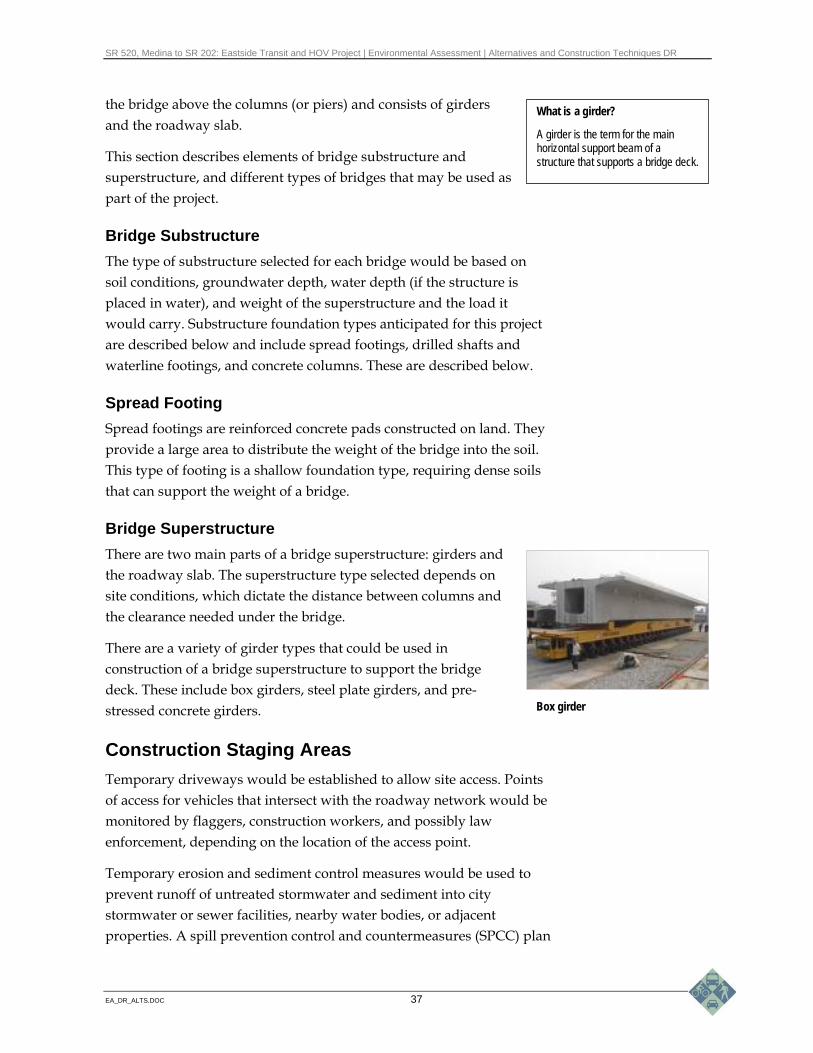
Bridge Construction
Bridge construction associated with the SR 520, Medina to SR 202: Eastside Transit and HOV Project would take place on land.
A bridge structure consists of two major parts: a substructure and a superstructure. The lower portion of a bridge is termed substructure and includes the bridge foundation and support structures, including columns and a cross beam or pier cap. The superstructure is the part of
A fish passage culvert
SR 520, Medina to SR 202: Eastside Transit and HOV Project | Environmental Assessment | Alternatives and Construction Techniques DR
EA_DR_ALTS.DOC 37
the bridge above the columns (or piers) and consists of girders and the roadway slab.
This section describes elements of bridge substructure and superstructure, and different types of bridges that may be used as part of the project.
Bridge Substructure
The type of substructure selected for each bridge would be based on soil conditions, groundwater depth, water depth (if the structure is placed in water), and weight of the superstructure and the load it would carry. Substructure foundation types anticipated for this project are described below and include spread footings, drilled shafts and waterline footings, and concrete columns. These are described below.
Spread Footing
Spread footings are reinforced concrete pads constructed on land. They provide a large area to distribute the weight of the bridge into the soil. This type of footing is a shallow foundation type, requiring dense soils that can support the weight of a bridge.
Bridge Superstructure
There are two main parts of a bridge superstructure: girders and the roadway slab. The superstructure type selected depends on site conditions, which dictate the distance between columns and the clearance needed under the bridge.
There are a variety of girder types that could be used in construction of a bridge superstructure to support the bridge deck. These include box girders, steel plate girders, and pre-stressed concrete girders.
Construction Staging Areas
Temporary driveways would be established to allow site access. Points of access for vehicles that intersect with the roadway network would be monitored by flaggers, construction workers, and possibly law enforcement, depending on the location of the access point.
Temporary erosion and sediment control measures would be used to prevent runoff of untreated stormwater and sediment into city stormwater or sewer facilities, nearby water bodies, or adjacent properties. A spill prevention control and countermeasures (SPCC) plan
What is a girder?
A girder is the term for the main horizontal support beam of a structure that supports a bridge deck.
Box girder

SR 520, Medina to SR 202: Eastside Transit and HOV Project | Environmental Assessment | Alternatives and Construction Techniques DR
EA_DR_ALTS.DOC 38
would be required to prevent and minimize the potential for spills of hazardous materials and pollutants.
Office trailers, placed on a temporary foundation, would be connected to available utilities, including power, telephone, water, and sewer, as needed. Connecting to these utilities may include pole installation and trench excavation to place water and sewer pipelines.
After construction was complete, staging areas would be restored and the area would be disconnected from any utilities.
Demolition and Disposal
Demolition of structures—whether buildings, roads, bridges, temporary facilities erected for construction, or other components—involves breaking, crushing, and cutting of structures for disposal. Demolition and excavation generate materials that need to be disposed of in a manner consistent with federal, state, and local laws and ordinances.
Dump trucks and haul trucks would travel over designated haul routes using city streets and state and county highways to arrive at the disposal sites. Multiple disposal site locations would likely be used.
Typical Construction Equipment
Roadway and bridge construction activities require a variety of construction equipment, as listed in Exhibit 14.

SR 520, Medina to SR 202: Eastside Transit and HOV Project | Environmental Assessment | Alternatives and Construction Techniques DR
EA_DR_ALTS.DOC 39
Exhibit 14. Typical Equipment and Use for Roadway and Bridge Construction
Equipment Typical Use
Air Compressor Pneumatic tool power and general maintenance
Backhoe General construction
Concrete Pump Concrete pumping
Concrete Saw Concrete removal, utilities access
Crane Materials handling, removal, and replacement
Excavator General construction and materials handling
Forklift Staging area work and hauling materials
Haul Truck Materials handling, general hauling
Jackhammer Pavement removal
Loader General construction and materials handling
Paver Roadway paving
Pile Driver Support-installation for structures and hillsides
Pump General construction use, water removal
Pneumatic Tools Miscellaneous construction work
Service Truck Repair and maintenance of equipment
Tractor Trailer Material removal and delivery
Utility Truck General project work
Vibratory equipment Activities to shore up hillside or install piles
Welder General project work
References and Bibliography
PSRC. 2006. 2006 Sub-County (Small Area) Forecasts of Population and Employment, Central Puget Sound Region. http://psrc.org/data/forecasts/index.htm. Accessed May 11, 2009.
WSDOT. 2006. SR 520 Bridge Replacement and HOV Project Draft Environmental Impact Statement. August 18, 2006.
WSDOT. 2007. Final Stormwater Management System Location and Siting Feasibility for 10% Design.
WSDOT. 2008a. Eastside Transit and HOV: Accelerated improvements to address ESHB 2878. September 2008.

SR 520, Medina to SR 202: Eastside Transit and HOV Project | Environmental Assessment | Alternatives and Construction Techniques DR
EA_DR_ALTS.DOC 40
WSDOT. 2008b. Fish Passage Technical Memorandum: Final Draft Stream Crossing, Fish Habitat, and Conceptual Fish Passage Structure Design Technical Memorandum. Volume 1. May 2008.
WSDOT. 2008c. 10% Design Constructability Review. June 2008.
WSDOT. 2008d. Highway Runoff Manual M 31-16. May 2006. http://www.wsdot.wa.gov/Environment/WaterQuality/Runoff/HighwayRunoffManual.htm.
WSDOT. 2009a. Ecosystems Discipline Report; SR 520, Medina to SR 202: Eastside Transit and HOV Project. November 2009.
WSDOT. 2009b. Noise Technical Memorandum, SR 520, Medina to SR 202: Eastside Transit and HOV Project. October 2009.
WSDOT. 2009c. Visual Quality and Aesthetics Technical Memorandum; SR 520, Medina to SR 202: Eastside Transit and HOV Project. November 2009.
WSDOT. 2009d. Water Resources Discipline Report; SR 520, Medina to SR 202: Eastside Transit and HOV Project. November 2009.
WSDOT. 2009e. Eastside Construction Techniques Technical Memorandum; SR 520, Medina to SR 202: Eastside Transit and HOV Project.