appendix g - surface water flooding - welcome to merton boroughs of wandsworth, merton, sutton and...
TRANSCRIPT

London Boroughs of Wandsworth, Merton, Sutton and Croydon Level 1 Strategic Flood Risk Assessment
Appendix G – Surface Water Flooding Data

London Boroughs of Wandsworth, Merton, Sutton and Croydon Level 1 Strategic Flood Risk Assessment
Appendix G December 2008 i
Introduction This appendix presents further details of the surface water flooding mapping presented within Appendix A, Figures 9A – 9D. The source of the data presented as a point series in the maps has been provided for each of the four Boroughs. This will allow further consideration of the specific reason why each location has been highlighted to ensure that the actual risk is considered on a site by site basis where appropriate.
Photographs of surface water flooding incidents obtained throughout the course of this study are also included for background information.
London Boroughs of Wandsworth, Merton, Sutton and Croydon Level 1 Strategic Flood Risk Assessment
Appendix G December 2008 ii
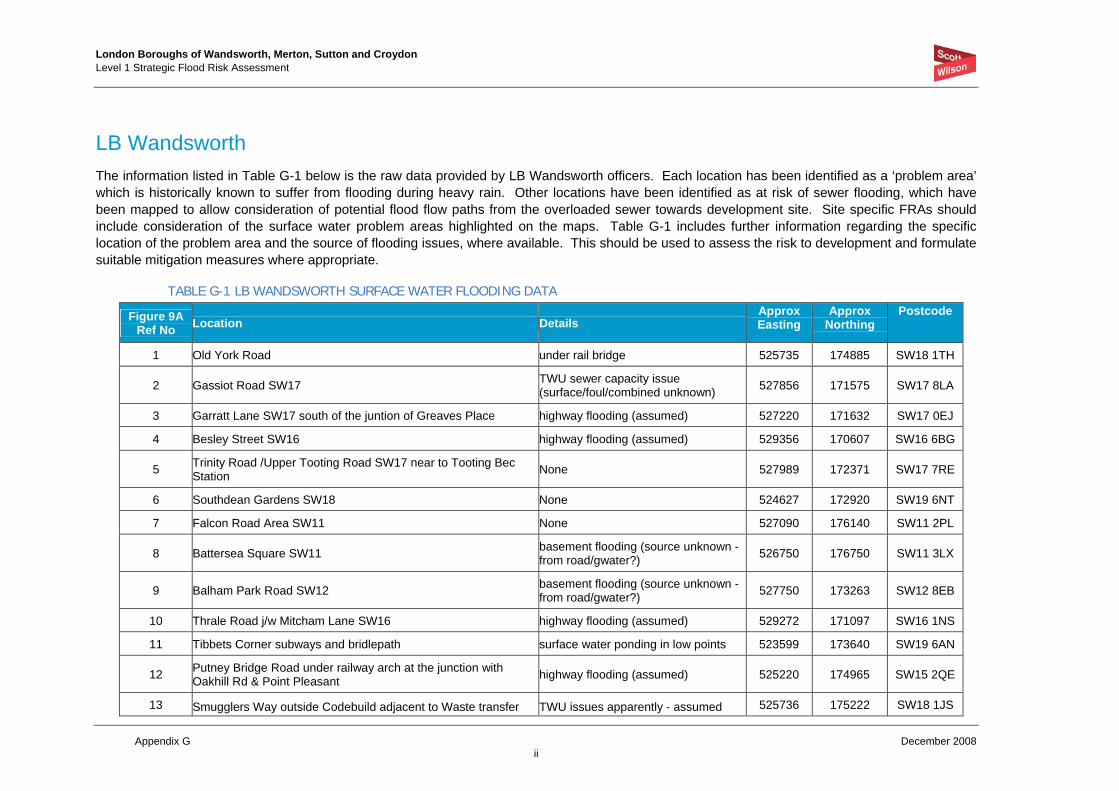
LB Wandsworth The information listed in Table G-1 below is the raw data provided by LB Wandsworth officers. Each location has been identified as a ‘problem area’ which is historically known to suffer from flooding during heavy rain. Other locations have been identified as at risk of sewer flooding, which have been mapped to allow consideration of potential flood flow paths from the overloaded sewer towards development site. Site specific FRAs should include consideration of the surface water problem areas highlighted on the maps. Table G-1 includes further information regarding the specific location of the problem area and the source of flooding issues, where available. This should be used to assess the risk to development and formulate suitable mitigation measures where appropriate.
TABLE G-1 LB WANDSWORTH SURFACE WATER FLOODING DATA
Figure 9A Ref No Location Details
Approx Easting
Approx Northing
Postcode
1 Old York Road under rail bridge 525735 174885 SW18 1TH
2 Gassiot Road SW17 TWU sewer capacity issue (surface/foul/combined unknown) 527856 171575 SW17 8LA
3 Garratt Lane SW17 south of the juntion of Greaves Place highway flooding (assumed) 527220 171632 SW17 0EJ
4 Besley Street SW16 highway flooding (assumed) 529356 170607 SW16 6BG
5 Trinity Road /Upper Tooting Road SW17 near to Tooting Bec Station None 527989 172371 SW17 7RE
6 Southdean Gardens SW18 None 524627 172920 SW19 6NT
7 Falcon Road Area SW11 None 527090 176140 SW11 2PL
8 Battersea Square SW11 basement flooding (source unknown - from road/gwater?) 526750 176750 SW11 3LX
9 Balham Park Road SW12 basement flooding (source unknown - from road/gwater?) 527750 173263 SW12 8EB
10 Thrale Road j/w Mitcham Lane SW16 highway flooding (assumed) 529272 171097 SW16 1NS
11 Tibbets Corner subways and bridlepath surface water ponding in low points 523599 173640 SW19 6AN
12 Putney Bridge Road under railway arch at the junction with Oakhill Rd & Point Pleasant highway flooding (assumed) 525220 174965 SW15 2QE
13 Smugglers Way outside Codebuild adjacent to Waste transfer TWU issues apparently - assumed 525736 175222 SW18 1JS

London Boroughs of Wandsworth, Merton, Sutton and Croydon Level 1 Strategic Flood Risk Assessment
Appendix G December 2008 iii
Figure 9A Ref No Location Details
Approx Easting
Approx Northing
Postcode
station, this one occurs regularly & Thames Water are aware of the problem
capacity exceedance
14 Battersea Park Rd area basement flooding from TWU low level No. sewer 528222 176669 SW11 4LY
15 Battersea Rise j/w St Johns Rd highway flooding 527449 175123 SW11 1NT
16 Breamore Close highway flooding 522319 173102 SW15 4NW
LB WANDSWORTH SURFACE WATER FLOODING PHOTOGRAPHS – JULY 2007
Tooting Bec Road Balham High Road
London Boroughs of Wandsworth, Merton, Sutton and Croydon Level 1 Strategic Flood Risk Assessment
Appendix G December 2008 iv
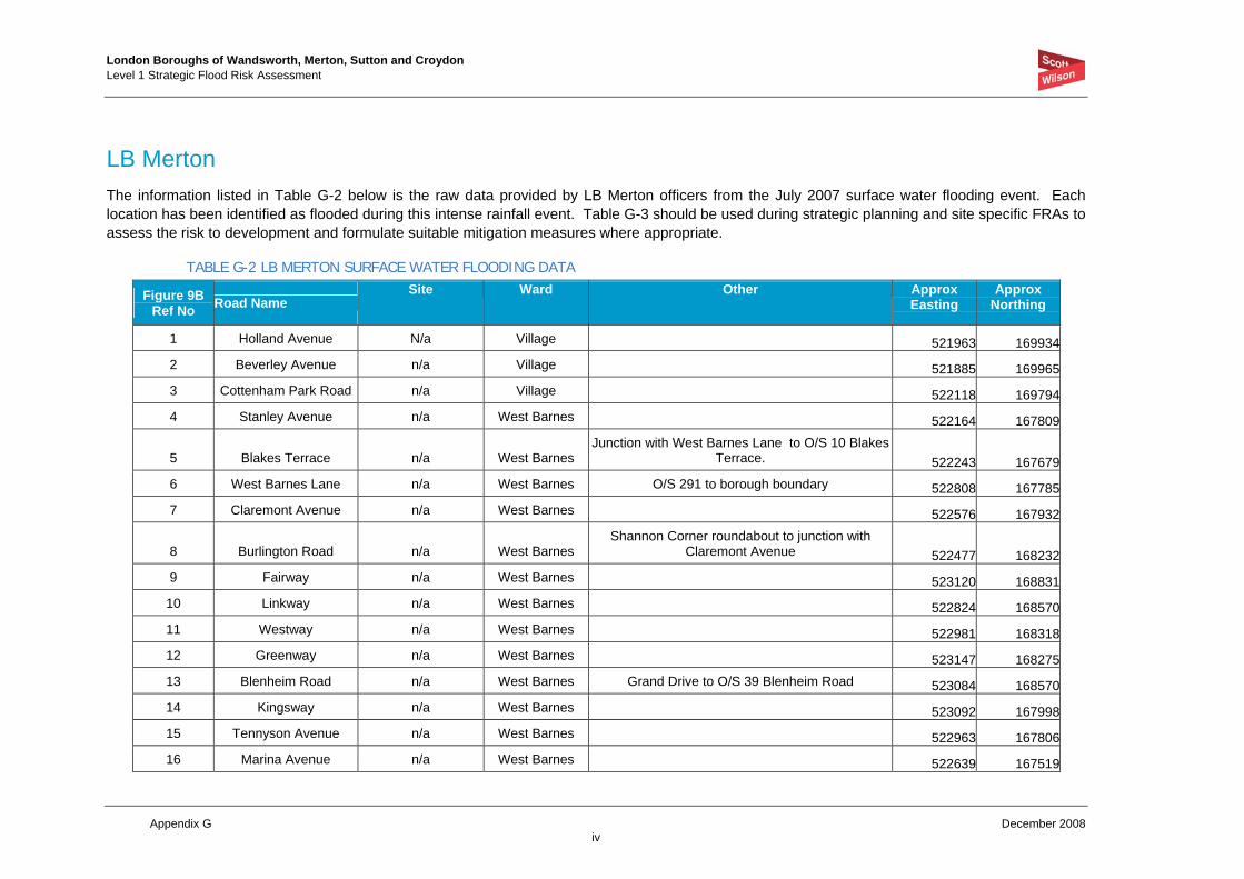
LB Merton The information listed in Table G-2 below is the raw data provided by LB Merton officers from the July 2007 surface water flooding event. Each location has been identified as flooded during this intense rainfall event. Table G-3 should be used during strategic planning and site specific FRAs to assess the risk to development and formulate suitable mitigation measures where appropriate.
TABLE G-2 LB MERTON SURFACE WATER FLOODING DATA
Figure 9B Ref No Road Name
Site Ward Other Approx Easting
Approx Northing
1 Holland Avenue N/a Village 521963 1699342 Beverley Avenue n/a Village 521885 1699653 Cottenham Park Road n/a Village 522118 1697944 Stanley Avenue n/a West Barnes 522164 167809
5 Blakes Terrace n/a West Barnes Junction with West Barnes Lane to O/S 10 Blakes
Terrace. 522243 1676796 West Barnes Lane n/a West Barnes O/S 291 to borough boundary 522808 1677857 Claremont Avenue n/a West Barnes 522576 167932
8 Burlington Road n/a West Barnes Shannon Corner roundabout to junction with
Claremont Avenue 522477 1682329 Fairway n/a West Barnes 523120 16883110 Linkway n/a West Barnes 522824 16857011 Westway n/a West Barnes 522981 16831812 Greenway n/a West Barnes 523147 16827513 Blenheim Road n/a West Barnes Grand Drive to O/S 39 Blenheim Road 523084 16857014 Kingsway n/a West Barnes 523092 16799815 Tennyson Avenue n/a West Barnes 522963 16780616 Marina Avenue n/a West Barnes 522639 167519
London Boroughs of Wandsworth, Merton, Sutton and Croydon Level 1 Strategic Flood Risk Assessment
Appendix G December 2008 v
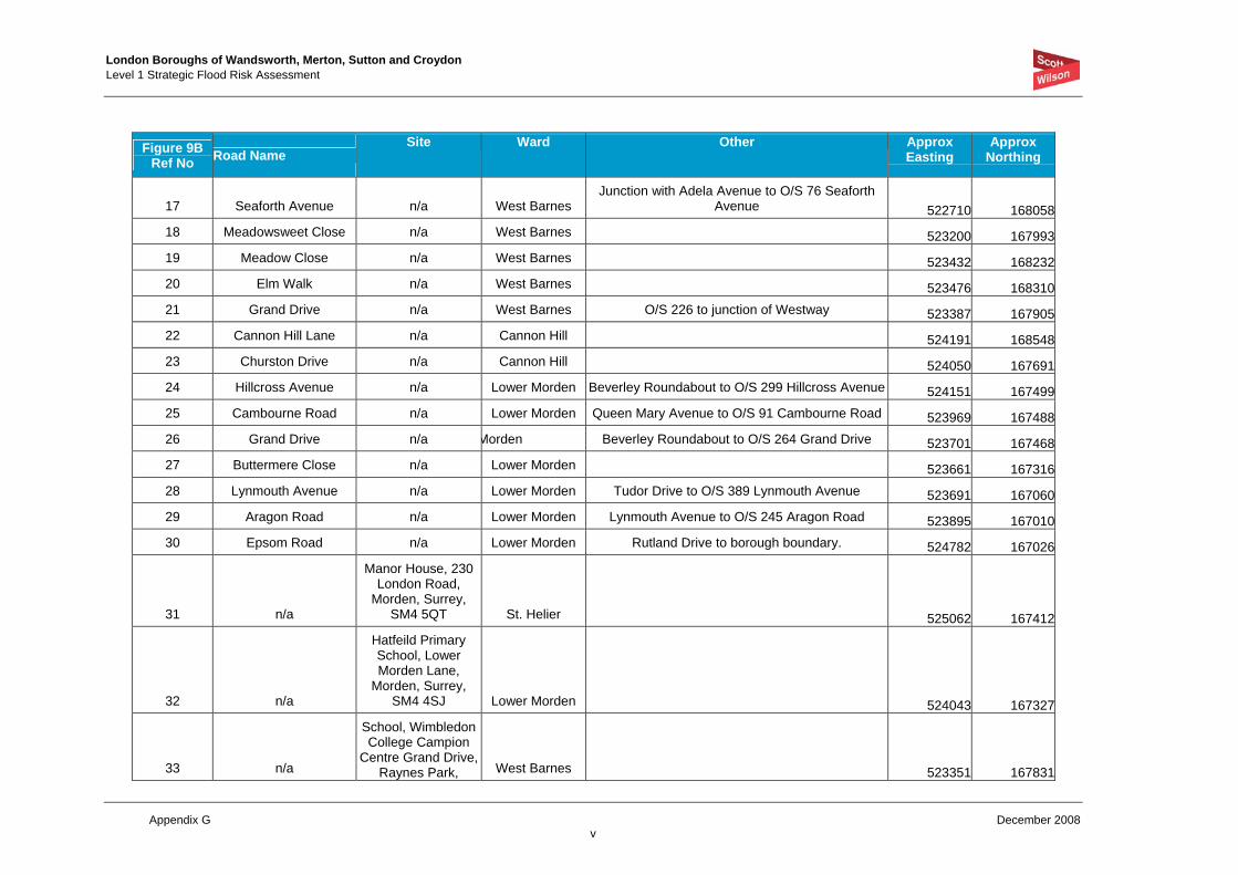
Figure 9B Ref No Road Name
Site Ward Other Approx Easting
Approx Northing
17 Seaforth Avenue n/a West Barnes Junction with Adela Avenue to O/S 76 Seaforth
Avenue 522710 16805818 Meadowsweet Close n/a West Barnes 523200 16799319 Meadow Close n/a West Barnes 523432 16823220 Elm Walk n/a West Barnes 523476 16831021 Grand Drive n/a West Barnes O/S 226 to junction of Westway 523387 16790522 Cannon Hill Lane n/a Cannon Hill 524191 16854823 Churston Drive n/a Cannon Hill 524050 16769124 Hillcross Avenue n/a Lower Morden Beverley Roundabout to O/S 299 Hillcross Avenue 524151 16749925 Cambourne Road n/a Lower Morden Queen Mary Avenue to O/S 91 Cambourne Road 523969 16748826 Grand Drive n/a Morden Beverley Roundabout to O/S 264 Grand Drive 523701 16746827 Buttermere Close n/a Lower Morden 523661 16731628 Lynmouth Avenue n/a Lower Morden Tudor Drive to O/S 389 Lynmouth Avenue 523691 16706029 Aragon Road n/a Lower Morden Lynmouth Avenue to O/S 245 Aragon Road 523895 16701030 Epsom Road n/a Lower Morden Rutland Drive to borough boundary. 524782 167026
31 n/a
Manor House, 230 London Road,
Morden, Surrey, SM4 5QT St. Helier 525062 167412
32 n/a
Hatfeild Primary School, Lower Morden Lane,
Morden, Surrey, SM4 4SJ Lower Morden 524043 167327
33 n/a
School, Wimbledon College Campion
Centre Grand Drive, Raynes Park, West Barnes 523351 167831

London Boroughs of Wandsworth, Merton, Sutton and Croydon Level 1 Strategic Flood Risk Assessment
Appendix G December 2008 vi
Figure 9B Ref No Road Name
Site Ward Other Approx Easting
Approx Northing
London,
34 n/a
Pavilion, Sir Joseph Hood Memorial Park Marina Avenue, New
Malden, Surrey West Barnes 522690 16746335 London Road n/a Merton Park O/S 111 to O/S Grosvenor Court 525502 16825136 Crown Road n/a Merton Park 525519 168431
37 n/a
St Ann's School, Bordesley Road, Morden, Surrey,
SM4 5LT St. Helier 525577 167929
38 n/a
Abbotsbury Primary School, 220
Abbotsbury Road, Morden, Surrey,
SM4 5JS St. Helier 525562 16777539 Bristol Road n/a St. Helier O/S 10 to O/S 8 Bristol Road 526154 16795440 Arras Avenue n/a Ravensbury 526319 16790841 Rose Avenue n/a Ravensbury 526282 16786142 Canterbury Road n/a St. Helier Croxden Walk to Darley Gardens 525988 16720243 Faversham Road n/a St. Helier Middleton Road to O/S 36 Faversham Road 525932 16731444 Glastonbury Road n/a St. Helier 525373 16679745 Marham Gardens n/a Ravensbury 526232 16728546 Montacute Road n/a Ravensbury 526576 167206
47 n/a
St Teresas Rc Primary School,
Montacute Road, Morden, Surrey,
SM4 6RL Ravensbury 526581 167115

London Boroughs of Wandsworth, Merton, Sutton and Croydon Level 1 Strategic Flood Risk Assessment
Appendix G December 2008 vii
Figure 9B Ref No Road Name
Site Ward Other Approx Easting
Approx Northing
48 Bishopford Road n/a Ravensbury Wandle Road to O/S 168 Bishopford Road 527033 16757749 Graham Road n/a Dundonald 524817 17024050 Quicks Road n/a Trinity 525934 17043551 Wycliffe Road n/a Trinity South Park Gardens to Ridley Road 525890 17056452 Haydon's Road n/a Trinity South Park Gardens to Tennyson Road 526085 17084053 Garfield Road n/a Trinity 526244 17091054 Boundary Road n/a Colliers Wood 526839 17085655 Dinton Road n/a Colliers Wood 526835 17095256 Chesham Road n/a Colliers Wood 526806 17099957 Kimble Road n/a Colliers Wood 526792 17093958 Acre Road n/a Colliers Wood 526936 17088859 Byegrove Road n/a Colliers Wood 526759 170555
60 High Street Colliers
Wood n/a Colliers Wood Cavendish Road to borough boundary 526966 17068761 Cavendish Road n/a Colliers Wood Norfolk Road to High Street Colliers Wood 527147 17044762 Colwood Gardens n/a Colliers Wood 526847 170214
63 n/a
Singlegate Primary School, South
Gardens, Colliers Wood, London,
SW19 2NT Colliers Wood 526926 17027664 Mryna Close n/a Colliers Wood 527302 17027765 Devonshire Road n/a Colliers Wood Lyveden Road to Wilton Road 527493 17048166 Lyveden Road n/a Colliers Wood 527561 17058867 Pitcairn Road n/a Colliers Wood 527779 170349

London Boroughs of Wandsworth, Merton, Sutton and Croydon Level 1 Strategic Flood Risk Assessment
Appendix G December 2008 viii
Figure 9B Ref No Road Name
Site Ward Other Approx Easting
Approx Northing
68 Crusoe Road n/a Colliers Wood 527654 17027269 Seely Road n/a Graveney 528334 17070670 Ascot Road n/a Graveney Seely Road to 54 Ascot Road 528088 17079071 Boscombe Road n/a Graveney Seely Road to 53 Boscombe Road 528142 17076972 Cromer Road n/a Graveney Seely Road to 49 Cromer Road 528195 17074573 Deal Road n/a Graveney Seely Road to 43 Deal Road 528246 170719
74 n/a
Links Primary School, Frinton Road, Tooting,
London, SW179EH Graveney 528355 17061275 Links Road n/a Graveney O/S 236 to London Road 528274 17054976 Ashbourne Road n/a Graveney Junction with Woodland Way to end of road. 528351 17043777 Rural Way n/a Graveney 528972 17044478 Figge's Road n/a Graveney 528080 17023279 St. James Road n/a Graveney 528214 17009680 Heathfield Drive n/a Lavender Fields 527320 16980681 Phipp's Bridge Road n/a Cricket Green O/S 225 to O/S 104 526468 16915482 Glebe Avenue n/a Cricket Green 527042 16910883 Collingwood Road n/a Cricket Green 527062 16895784 Rodney Road n/a Cricket Green 527115 16896885 miles Road n/a Cricket Green 527173 16887686 Frimley Gardens n/a Cricket Green 527211 16880087 Chantry Way n/a Cricket Green 526938 16876088 Benedict Road n/a Cricket Green 526938 168662

London Boroughs of Wandsworth, Merton, Sutton and Croydon Level 1 Strategic Flood Risk Assessment
Appendix G December 2008 ix
Figure 9B Ref No Road Name
Site Ward Other Approx Easting
Approx Northing
89 n/a
Cricket Green Special School, 9A Lower Green West, Mitcham, Surrey,
CR4 3AF Cricket Green 527382 16855390 Church Road n/a Cricket Green O/S 46 to junction with Lower Green West 527387 16862691 London Road n/a Cricket Green Elmwood Road to Vestry Hall 527643 16870992 Grove Road n/a Figges Marsh 528353 168976
93 Tamworth lane n/a Pollards Hill Junction with Manor Road to junction with Acacia
Road 528787 16877694 Manor Way n/a Longthornton 529350 168701
95 Manor Road n/a Pollards Hill Junction with Tamworth Lane and borough
boundary. 529405 16863496 Kingsmead Avenue n/a Longthornton 529455 16893597 Rowan Road n/a Longthornton Junction of Manor Way to borough boundary 529303 16933998 Lilian Road n/a Longthornton 529218 169775
99 n/a
Stanford Primary School, Chilmark Road, Streatham,
London, SW16 5HB Longthornton 529815 169493100 Sherwood Park Road n/a Pollards Hill 529246 168381101 Yorkshire Road n/a Pollards Hill 530193 168120102 Crown Lane n/a Merton Park 525400 168496103 Lower Morden Lane n/a Lower Morden Junction with Buttermere Close to Garth Road 523525 167192
104 Garth Road n/a Lower Morden Junction with Lower Morden Lane to O/S 318
Garth Road 523479 167010
London Boroughs of Wandsworth, Merton, Sutton and Croydon Level 1 Strategic Flood Risk Assessment
Appendix G December 2008 x
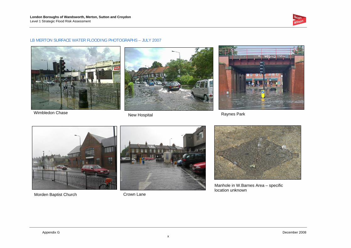
LB MERTON SURFACE WATER FLOODING PHOTOGRAPHS – JULY 2007
Wimbledon Chase New Hospital Raynes Park
Morden Baptist Church Crown Lane
Manhole in W.Barnes Area – specific location unknown

London Boroughs of Wandsworth, Merton, Sutton and Croydon Level 1 Strategic Flood Risk Assessment
Appendix G December 2008 xi
West Barnes Lane Linkway
Kingsway W.Barnes Lane Crossway/West Barnes Lane junction
Crossway

London Boroughs of Wandsworth, Merton, Sutton and Croydon Level 1 Strategic Flood Risk Assessment
Appendix G December 2008 xii
LB Sutton The information listed in Table G-3 below is the raw data provided by LB Sutton officers from the Borough Flood Plan. Each location has been identified as at risk from flooding due to gullies becoming blocked or a lack of capacity during intense rainfall events. The locations are categorised in priority sequence (A - highest to D - lowest) based on severity of effect and the historical frequency of flooding. Table G-2 should be used during strategic planning and site specific FRAs to assess the risk to development and formulate suitable mitigation measures where appropriate.
TABLE G-3 LB SUTTON SURFACE WATER FLOODING DATA
Figure 9C Ref No Location
Source Approx Easting
Approx Northing
Postcode
1 Downside Road (j/o Banstead Road) Flood Plan - PriorityA 527259 163597 SM5 3NW
2 Ruskin Road Flood Plan – Priority A 527891 164234 SM5 3SS
3 Grange Vale Flood Plan - Priority A 525902 163390 SM2 6AH
4 London Road Hackbridge (Whole area) Flood plan - Priority A 528650 165780 SM6 7ET
5 London Road Wallington (Whole area) Flood Plan - Priority A 528675 165045 SM6 7BY
6 Beddington Lane (Whole area) Flood Plan - Priority B 529237 167492 CR9 4NX
7 The Gallop Flood Plan - Priority B 526750 162250 SM5 4HP
8 Strawberry Lane (j/o Nightingale Road) Flood Plan - Priority B 527991 165419 SM5 2LY
9 Wrythe Green Road/West Street (Whole area) Flood Plan - Priority C 527659 165246 SM5 2EH
10 Woodmansterne Lane Flood Plan - Priority C 528074 161254 SM5 4BJ
11 Croydon Lane Flood Plan - Priority C 525974 160210 SM7 3AF
12 Worcester Road Flood Plan - Priority C 525241 163382 SM2 6QQ
13 Grosvenor Avenue Flood Plan - Priority C 528025 163777 SM5 3EP
14 Brighton Road Flood Plan - Priority C 526000 163201 SM2 5TR
15 Sutton Common Road Flood Plan - Priority C 524655 166655 SM3 9JJ
16 Erskine Road Flood Plan - Priority C 526745 164979 SM1 3AS
17 Hackbridge Road (Outside school) Flood Plan - Priority C 528157 165837 SM5 2DD

London Boroughs of Wandsworth, Merton, Sutton and Croydon Level 1 Strategic Flood Risk Assessment
Appendix G December 2008 xiii
Figure 9C Ref No Location
Source Approx Easting
Approx Northing
Postcode
18 Egmont Road jnc Devonshire Road Flood Plan - Priority C 526355 163113 SM2 5HH
19 Buckhurst Avenue Flood Plan - Priority D 527407 166132 SM5 1NX
20 Station Road, Belmont Flood Plan - Priority D 525335 162080 SM2 6DF
21 Montague Gardens Flood Plan - Priority D 529340 164524 SM6 8ER
22 Boundary Road Flood Plan - Priority D 528469 163161 SM5 4AD
23 The Chase Flood Plan - Priority D 530250 164250 SM6 8QH
24 Richmond Road Flood Plan - Priority D 522614 169595 SW20 0PG
25 Orchard Avenue Flood Plan - Priority D 521452 168934 KT3 4JU
26 Matlock Crescent Flood Plan - Priority D 524377 164739 SM3 9SN
London Boroughs of Wandsworth, Merton, Sutton and Croydon Level 1 Strategic Flood Risk Assessment
Appendix G December 2008 xiv
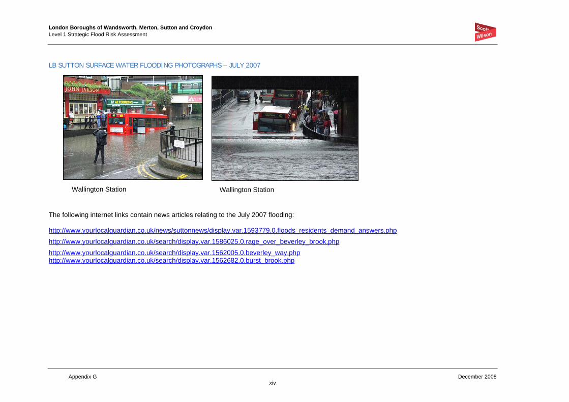
LB SUTTON SURFACE WATER FLOODING PHOTOGRAPHS – JULY 2007
The following internet links contain news articles relating to the July 2007 flooding: http://www.yourlocalguardian.co.uk/news/suttonnews/display.var.1593779.0.floods_residents_demand_answers.php http://www.yourlocalguardian.co.uk/search/display.var.1586025.0.rage_over_beverley_brook.php http://www.yourlocalguardian.co.uk/search/display.var.1562005.0.beverley_way.php http://www.yourlocalguardian.co.uk/search/display.var.1562682.0.burst_brook.php
Wallington Station Wallington Station

London Boroughs of Wandsworth, Merton, Sutton and Croydon Level 1 Strategic Flood Risk Assessment
Appendix G December 2008 xv
LB Croydon The information listed in Table G-4 below is the raw data provided by LB Croydon officers from the Borough Flood Plan. Each location has been identified as at risk from flooding due to gullies becoming blocked or a lack of capacity during intense rainfall events. The locations are categorised in priority sequence (A - highest to D - lowest) based on severity of effect and the historical frequency of flooding. Table G-4 should be used during strategic planning and site specific FRAs to assess the risk to development and formulate suitable mitigation measures where appropriate.
TABLE G-4 LB CROYDON SURFACE WATER FLOODING DATA
Figure 9D Ref No Location
House/Flood Vulnerability
Approx Easting Approx Northing
Postcode
1 Parker Road H 532363 164771 CR0 1DU
2 Canning Road H 533573 165987 CR0 6QB
3 Barrow Road H 531472 164121 CR0 4BZ
4 Portland Road under bridge H 534099 168419 SE25 4PE
5 Elmside H 537750 163750 CR0 9DW
6 King Gardens Waddon H 531672 164486 CR0 4DD
7 Addiscombe Road 237 H 533218 165739 CR0 6SD
8 Arundel Avenue 88 H 534256 162167 CR2 8BL
9 Balfont Close 7-13 H 534303 160954 CR2 9LL
10 Lodge Lane 95-105 H 537181 163786 CR0 5AR
11 Minster Drive H 533248 164932 CR0 5ND
12 Sunnybank 27. H 536475 158549 CR6 9SS
13 Selhurst Road under bridge F 533121 167538 SE25 5QE
14 Caterham Drive F 531681 158165 CR5 1JE
15 Chipstead Valley Road F 528345 159165 CR5 3BW
16 Kenley Lane F 532462 159887 CR8 5DU

London Boroughs of Wandsworth, Merton, Sutton and Croydon Level 1 Strategic Flood Risk Assessment
Appendix G December 2008 xvi
Figure 9D Ref No Location
House/Flood Vulnerability
Approx Easting Approx Northing
Postcode
17 Bourne Park Close F 533423 159436 CR8 5BJ
18 Smitham Bottom Lane F 529380 161671 CR8 3PY
19 Brighton Road/ St Augustines F 532519 163256 CR2 6AG
20 Brighton Road /Haling Park Road F 532527 163788 CR2 6EF
21 Lower Barn Road F 532780 160801 CR8 1HY
22 Purley Oaks Road F 532606 162556 CR2 0NP
23 Wellesley road underpass F 532325 166217 CR9 2UZ
24 Old Farleigh Road F 535095 162145 CR2 8PB
25 Roman Way F 531848 165743 CR0 1XD
26 Godstone Road by River Bourne F 532368 160283 CR8 5JD
27 Valley Road Kenley F 530619 171260 SW16 2EW
28 Marlpit Lane (bottom) F 529935 159110 CR5 2HA
29 Kent Gate Way by boundary F 536930 163666 CR0 5AR
30 King Henrys Drive F 538198 162874 CR0 0PD
31 Arnhem Drive j/w Queen Elizabeth Drive F 538878 161876 CR0 0EE

London Boroughs of Wandsworth, Merton, Sutton and Croydon Level 1 Strategic Flood Risk Assessment
Appendix G December 2008 xvii
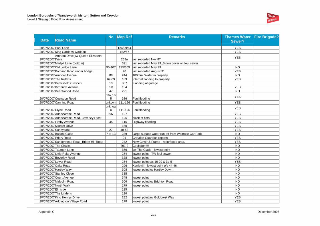
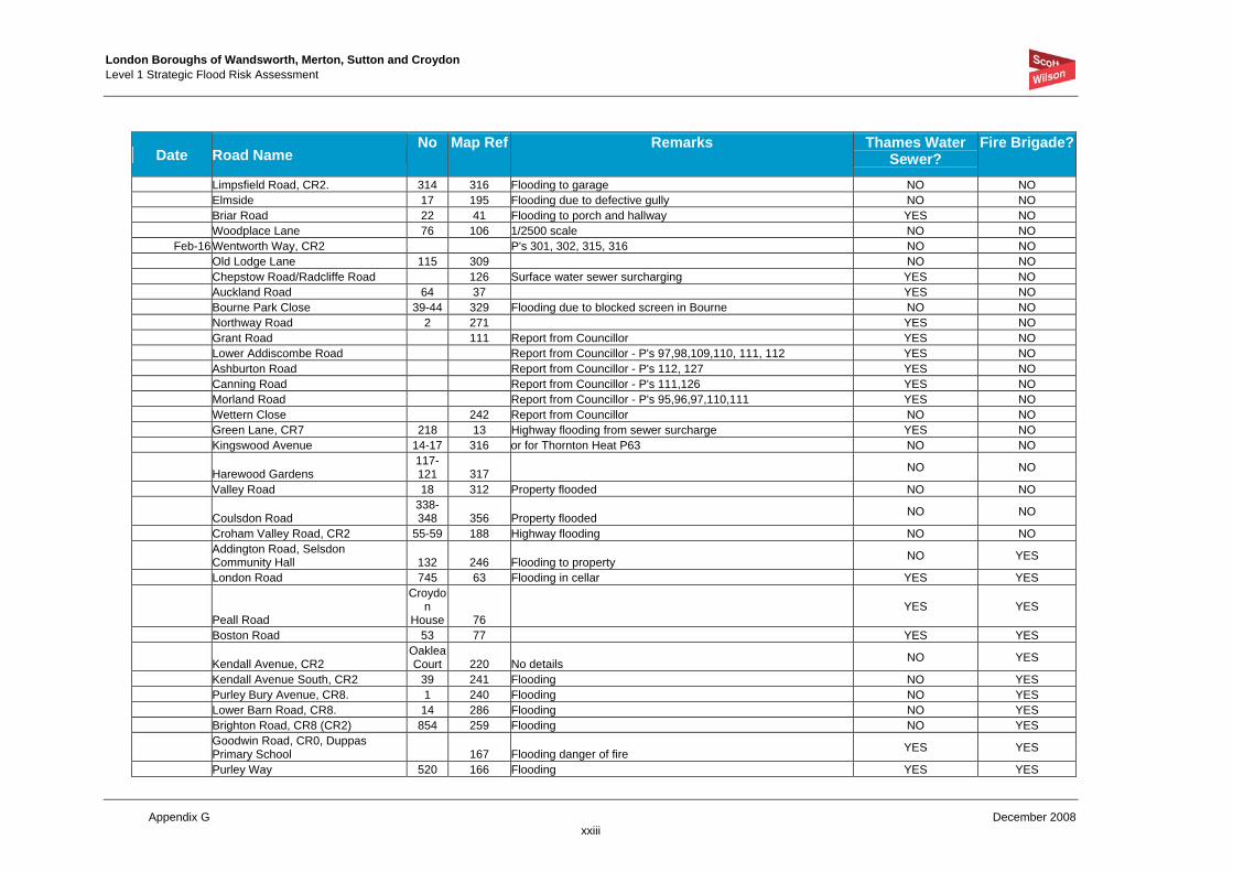
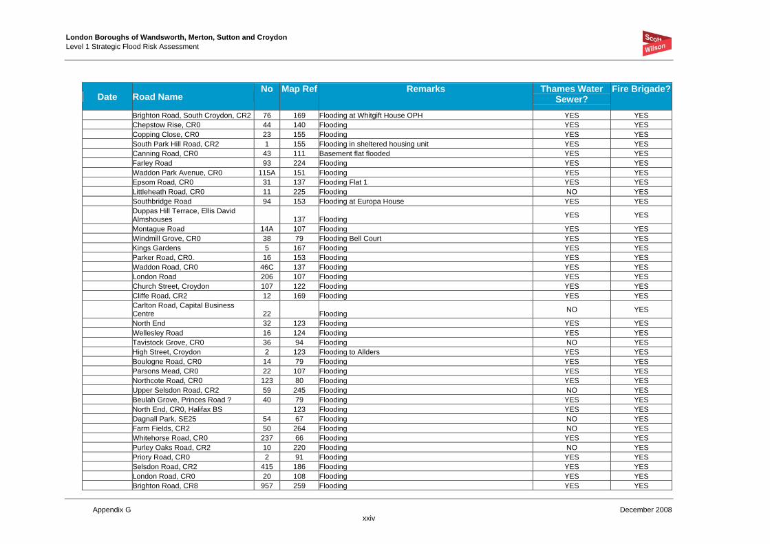
LB Croydon has also provided the following list of locations flooded during the July 2007 event, however the information has not been provided in a GIS format therefore it has not possible to graphically represent this points. However Table G-5 below should be reviewed during preparation of site specific FRAs to ensure all surface water information is considered on a site by site basis.
TABLE G-5 LB CROYDON JULY 2007 SURFACE WATER FLOODING DATA (NOT MAPPED)
Date Road Name No Map Ref Remarks Thames Water
Sewer? Fire Brigade?
15/07/2007Lower Barn Road 273 Under Bridge - Croydon Advertiser (20/07/07) YES 15/07/2007Bradmore Way 334 Garden and Garage - Croydon Advertiser (20/07/07) NO 15/07/2007Westfield Avenue 286 Garage to 31 Copthorne Rise flooded. NO 15/07/2007Upper Selsdon Road 141 223 NO 15/07/2007Downs Road 119 345 NO 20/07/2007Selhurst Road 67 Under bridge - last recorded May 99 YES 20/07/2007Caterham Drive 1,3,5,7 349 Foul Flooding YES
20/07/2007Chipstead Valley Road 306/18/19/
20/21 Last recorded August 97
20/07/2007Kenley Lane/Valley Road 297 Last recorded May 99 NO 20/07/2007Bourne Park Close 313/28/29 Grid on Bourne blocked
20/07/2007Smitham Bottom Lane 255/67/68/
80 Cover on soakaway lifted damaging road NO
20/07/2007Brighton Road/St Augustines Avenue 201 YES 20/07/2007Brighton Road/Haling Park Road 185 YES 20/07/2007Parker Road 153 No. 22 recorded July 97 YES 20/07/2007Lower Barn Road repeated 273/74/86 20/07/2007Old Town Subways 138 Subways positioned North & East 20/07/2007Purley Cross 151/66 YES
20/07/2007Purley Oaks Road/Purley Oaks Station Road 219/20 Last recorded May 99 road and properties flooded YES
20/07/2007Wellesley Road 124 Underpass flooded last recorded Dec 94 YES
20/07/2007Barrow Road 166/7/8/82/
83 Last recorded Oct 87_ Road and Gardens flooded YES
20/07/2007Carlton Road 185/201 Industrial estate_last recorded Jan 98 20/07/2007Asmar Close 10,12 307 last recorded May 99_No. 10 YES
20/07/2007Kent Gate Way/Gravel Hill Roundabout 209 last recorded Oct 87_ Roundabout and Garage flooded YES
20/07/2007Kent Gate Way 164 FWS surcharging to Borough Boundary YES 20/07/2007Fox Hill/Reynard Drive 18 No kerb rain washed over footway into property
20/07/2007Foxley Lane/Bridle Road 236
Road damaged due to flooding, also damage around cover & frame of soakaway, becoming noisy. At the same junction in The Bridle Road another cover & frame effected, but not shown on the records.
NO
London Boroughs of Wandsworth, Merton, Sutton and Croydon Level 1 Strategic Flood Risk Assessment
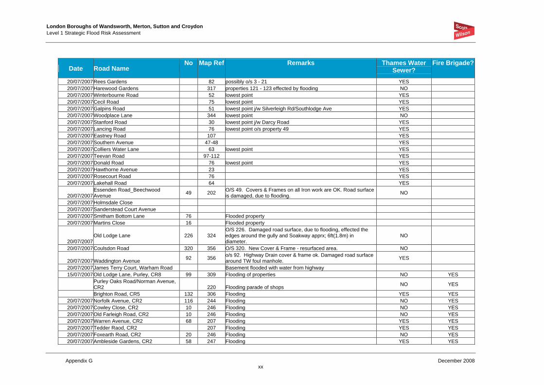
Appendix G December 2008 xviii
Date Road Name No Map Ref Remarks Thames Water
Sewer? Fire Brigade?
20/07/2007Park Lane 124/39/54 YES 20/07/2007King Gardens Waddon 152/67 YES
20/07/2007Arnhem Drive j/w Queen Elizabeth Drive 253a last recorded Nov 87 YES
20/07/2007Marlpit Lane (bottom) 321 last recorded May 99_Blown cover on foul sewer 20/07/2007Old Lodge Lane 95-107 295/309 last recorded May 99 NO 20/07/2007Portland Road under bridge 70 last recorded August 91 YES 20/07/2007Arundel Avenue 88 244 180mm. Water in property NO 20/07/2007The Ruffets 67-69 189 Internal flooding to property YES 20/07/2007Petersfield Crescent 13 307 Flooding of garage 20/07/2007Birdhurst Avenue 6,8 154 YES 20/07/2007Beechwood Road 47 221 NO
20/07/2007Coulsdon Road 167,16
5 356 Foul flooding YES
20/07/2007Canning Road unkown 111-126 Foul flooding YES
20/07/2007Clyde Road unknow
n 111-126 Foul flooding YES
20/07/2007Addiscombe Road 237 127 YES 20/07/2007Addiscombe Road, Beverley Hyrst 126 block of flats YES 20/07/2007Firsby Avenue 45 116 Highway flooding YES 20/07/2007Minster Drive 150 YES 20/07/2007Sunnybank 27 48-58 YES 20/07/2007Balfont Close 7 to 13 289 Large surface water run-off from Waitrose Car Park NO 20/07/2007Priory Road 91 Croydon Guardian reports YES 20/07/2007Sanderstead Road_Briton Hill Road 242 New Cover & Frame - resurfaced area. YES 20/07/2007The Chase 291-2 Coulsdon!!!! NO 20/07/2007Taunton Lane 356 j/w The Glade - lowest point NO 20/07/2007Little Roke Avenue 284 lowest point - TW foul sewer NO 20/07/2007Beverley Road 328 lowest point NO 20/07/2007Lower Road 284 lowest point o/s 16-20 & 3a-5 YES 20/07/2007Oaks Road 296 Kenley!!! - lowest point o/s 44-46 NO 20/07/2007Hartley Way 308 lowest point j/w Hartley Down NO 20/07/2007Stanley Close 335 NO 20/07/2007Court Avenue 348 lowest point NO 20/07/2007Malcolm Road 306 lowest point j/w Brighton Road NO 20/07/2007North Walk 179 lowest point NO 20/07/2007Elmside 195 NO 20/07/2007The Lindens 196 NO 20/07/2007King Henrys Drive 232 lowest point j/w Goldcrest Way YES 20/07/2007Addington Village Road 178 lowest point YES

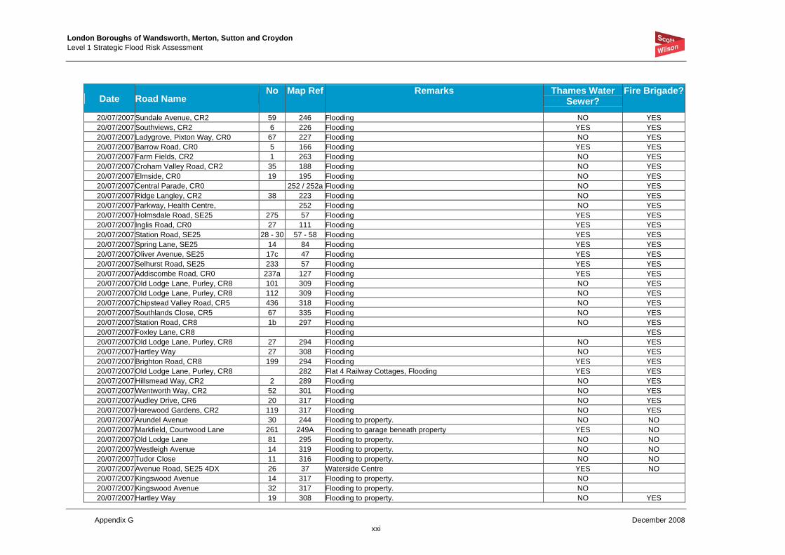
London Boroughs of Wandsworth, Merton, Sutton and Croydon Level 1 Strategic Flood Risk Assessment
Appendix G December 2008 xix
Date Road Name No Map Ref Remarks Thames Water
Sewer? Fire Brigade?
20/07/2007Broadcombe 207 lowest point YES 20/07/2007Southbridge Road 153 lowest point towards Lower Coombe Street YES 20/07/2007Sandrock Place 160 YES 20/07/2007Beaconsfield Road 80 lowest point YES 20/07/2007Green Lane 13-22 lowest point YES 20/07/2007Norfolk Avenue 244 lowest point NO 20/07/2007High Street, South Norwood 58 lowest point YES 20/07/2007Granville Gardens 21 lowest point YES 20/07/2007Orchard Way 88 lowest point YES 20/07/2007Underwood 180-96 YES 20/07/2007Ena Road 30-40 YES 20/07/2007Shirley Church Road 129-44 lowest point YES 20/07/2007North Walk, Shirley does not exist-only in addington 20/07/2007Chaldon Way 334 lowest point NO 20/07/2007Dickensons Lane 83 YES 20/07/2007Oak Avenue 118 lowest point YES 20/07/2007Oaklands Avenue 42-52 YES 20/07/2007Beulah Hill 16 j/w Spa Hill YES 20/07/2007Bissenden Road North 125 lowest point towards Cedar Road YES 20/07/2007Westfield Road? 122 YES 20/07/2007Milton Road 94 lowest point towards Gladstone Road YES 20/07/2007Upper Selsdon Road 202 lowest point j/w West Hill NO 20/07/2007Stewart Road 54 or as Stuart Road YES 20/07/2007Boswell Road 54 lowest point j/w Brigtock Road YES 20/07/2007Semley Road 31 lowest point j/w Hatch Road YES 20/07/2007Purley Park Road 239 lowest point o/s 49 YES 20/07/2007Kingswood Avenue 317 lowest point NO 20/07/2007Raymead Avenue 63-4 YES 20/07/2007Beckford Road 82-96 YES 20/07/2007South Norwood Hill 26-36 YES 20/07/2007Zermatt Road 54-65 possibly combined?!! YES 20/07/2007Shrublands Avenue 148 lowest point j/w Broom Road YES 20/07/2007Higher Drive 271 lowest point - north end NO 20/07/2007Tenterden Road 97 lowest point YES 20/07/2007Cedar Road 124 lowest point YES 20/07/2007Hermitage Road, Upper Norwood 9 lowest point j/w Hancock Road YES 20/07/2007Queen Street 138 lowest point YES 20/07/2007The Horseshoe 280 lowest point o/s Little Mead 1a. NO 20/07/2007Strathyre Avenue 42 lowest point YES 20/07/2007Highbury Avenue 32 lowest point YES
London Boroughs of Wandsworth, Merton, Sutton and Croydon Level 1 Strategic Flood Risk Assessment
Appendix G December 2008 xx
Date Road Name No Map Ref Remarks Thames Water
Sewer? Fire Brigade?
20/07/2007Rees Gardens 82 possibly o/s 3 - 21 YES 20/07/2007Harewood Gardens 317 properties 121 - 123 effected by flooding NO 20/07/2007Winterbourne Road 52 lowest point YES 20/07/2007Cecil Road 75 lowest point YES 20/07/2007Galpins Road 51 lowest point j/w Silverleigh Rd/Southlodge Ave YES 20/07/2007Woodplace Lane 344 lowest point NO 20/07/2007Stanford Road 30 lowest point j/w Darcy Road YES 20/07/2007Lancing Road 76 lowest point o/s property 49 YES 20/07/2007Eastney Road 107 YES 20/07/2007Southern Avenue 47-48 YES 20/07/2007Colliers Water Lane 63 lowest point YES 20/07/2007Teevan Road 97-112 YES 20/07/2007Donald Road 76 lowest point YES 20/07/2007Hawthorne Avenue 23 YES 20/07/2007Rosecourt Road 76 YES 20/07/2007Lakehall Road 64 YES
20/07/2007Essenden Road_Beechwood Avenue 49 202 O/S 49. Covers & Frames on all Iron work are OK. Road surface
is damaged, due to flooding. NO
20/07/2007Holmsdale Close 20/07/2007Sanderstead Court Avenue 20/07/2007Smitham Bottom Lane 76 Flooded property 20/07/2007Martins Close 16 Flooded property
20/07/2007Old Lodge Lane 226 324
O/S 226. Damaged road surface, due to flooding, effected the edges around the gully and Soakway apprx; 6ft(1.8m) in diameter.
NO
20/07/2007Coulsdon Road 320 356 O/S 320. New Cover & Frame - resurfaced area. NO
20/07/2007Waddington Avenue 92 356 o/s 92. Highway Drain cover & frame ok. Damaged road surface around TW foul manhole. YES
20/07/2007James Terry Court, Warham Road Basement flooded with water from highway 15/07/2007Old Lodge Lane, Purley, CR8 99 309 Flooding of properties NO YES
Purley Oaks Road/Norman Avenue, CR2 220 Flooding parade of shops NO YES
Brighton Road, CR5 132 306 Flooding YES YES 20/07/2007Norfolk Avenue, CR2 116 244 Flooding NO YES 20/07/2007Cowley Close, CR2 10 246 Flooding NO YES 20/07/2007Old Farleigh Road, CR2 10 246 Flooding NO YES 20/07/2007Warren Avenue, CR2 68 207 Flooding YES YES 20/07/2007Tedder Raod, CR2 207 Flooding YES YES 20/07/2007Foxearth Road, CR2 20 246 Flooding NO YES 20/07/2007Ambleside Gardens, CR2 58 247 Flooding YES YES
London Boroughs of Wandsworth, Merton, Sutton and Croydon Level 1 Strategic Flood Risk Assessment
Appendix G December 2008 xxi
Date Road Name No Map Ref Remarks Thames Water
Sewer? Fire Brigade?
20/07/2007Sundale Avenue, CR2 59 246 Flooding NO YES 20/07/2007Southviews, CR2 6 226 Flooding YES YES 20/07/2007Ladygrove, Pixton Way, CR0 67 227 Flooding NO YES 20/07/2007Barrow Road, CR0 5 166 Flooding YES YES 20/07/2007Farm Fields, CR2 1 263 Flooding NO YES 20/07/2007Croham Valley Road, CR2 35 188 Flooding NO YES 20/07/2007Elmside, CR0 19 195 Flooding NO YES 20/07/2007Central Parade, CR0 252 / 252a Flooding NO YES 20/07/2007Ridge Langley, CR2 38 223 Flooding NO YES 20/07/2007Parkway, Health Centre, 252 Flooding NO YES 20/07/2007Holmsdale Road, SE25 275 57 Flooding YES YES 20/07/2007Inglis Road, CR0 27 111 Flooding YES YES 20/07/2007Station Road, SE25 28 - 30 57 - 58 Flooding YES YES 20/07/2007Spring Lane, SE25 14 84 Flooding YES YES 20/07/2007Oliver Avenue, SE25 17c 47 Flooding YES YES 20/07/2007Selhurst Road, SE25 233 57 Flooding YES YES 20/07/2007Addiscombe Road, CR0 237a 127 Flooding YES YES 20/07/2007Old Lodge Lane, Purley, CR8 101 309 Flooding NO YES 20/07/2007Old Lodge Lane, Purley, CR8 112 309 Flooding NO YES 20/07/2007Chipstead Valley Road, CR5 436 318 Flooding NO YES 20/07/2007Southlands Close, CR5 67 335 Flooding NO YES 20/07/2007Station Road, CR8 1b 297 Flooding NO YES 20/07/2007Foxley Lane, CR8 Flooding YES 20/07/2007Old Lodge Lane, Purley, CR8 27 294 Flooding NO YES 20/07/2007Hartley Way 27 308 Flooding NO YES 20/07/2007Brighton Road, CR8 199 294 Flooding YES YES 20/07/2007Old Lodge Lane, Purley, CR8 282 Flat 4 Railway Cottages, Flooding YES YES 20/07/2007Hillsmead Way, CR2 2 289 Flooding NO YES 20/07/2007Wentworth Way, CR2 52 301 Flooding NO YES 20/07/2007Audley Drive, CR6 20 317 Flooding NO YES 20/07/2007Harewood Gardens, CR2 119 317 Flooding NO YES 20/07/2007Arundel Avenue 30 244 Flooding to property. NO NO 20/07/2007Markfield, Courtwood Lane 261 249A Flooding to garage beneath property YES NO 20/07/2007Old Lodge Lane 81 295 Flooding to property. NO NO 20/07/2007Westleigh Avenue 14 319 Flooding to property. NO NO 20/07/2007Tudor Close 11 316 Flooding to property. NO NO 20/07/2007Avenue Road, SE25 4DX 26 37 Waterside Centre YES NO 20/07/2007Kingswood Avenue 14 317 Flooding to property. NO 20/07/2007Kingswood Avenue 32 317 Flooding to property. NO 20/07/2007Hartley Way 19 308 Flooding to property. NO YES

London Boroughs of Wandsworth, Merton, Sutton and Croydon Level 1 Strategic Flood Risk Assessment
Appendix G December 2008 xxii
Date Road Name No Map Ref Remarks Thames Water
Sewer? Fire Brigade?
20/07/2007Sanderstead court Avenue, CR2. 14 289 Flooding to property. NO YES 20/07/2007Brighton Road, CR8. 223 293 Flooding to property. YES YES 20/07/2007Brighton Road, CR5. 112 306 Flooding to property. YES YES 20/07/2007The Horseshoe, CR5 4 280 Flooding to property. NO YES 20/07/2007Holmes Close, CR8. 3 282 Flooding to property. NO YES 20/07/2007Brighton Road, CR5. 149 306 Flooding to property. YES YES 20/07/2007Chipstead Valley Road, CR5 434 318 Flooding to property. NO YES 20/07/2007Balfont Close, CR2. 13 289 Large surface water run-off from Waitrose Car Park NO YES 20/07/2007Kendal Avenue South, CR2. 39 241 Flooding to property. NO YES 20/07/2007Westfield Avenue 41 287 Flooding to property. NO YES 20/07/2007Balfont Close, CR2. 1 289 Flooding to property. NO YES 20/07/2007Sanderstead court Avenue, CR2. 54 289 Flooding to property. NO YES 20/07/2007Brighton Road, CR5. 151 306 Flooding to property. YES YES 20/07/2007Brighton Road, CR2. 915 259 Flooding to property. YES YES 20/07/2007Limpsfield Road, CR2. 258 316 Flooding to property. YES YES 20/07/2007Station Road, CR8 297 Flooding - The Stables NO YES 20/07/2007Parker Road, CR0. 2 153 Flooding to property. YES YES 20/07/2007Sanderstead court Avenue, CR2. 30 289 Flooding to property. NO YES 20/07/2007Hayes Lane, CR8. 29 311 Flooding to property. NO YES 20/07/2007Lower Barn Road, CR8. 18 286 Flooding to property. NO YES 20/07/2007Caterham Drive, CR5. 57 349 Flooding to property. NO YES 20/07/2007Brighton Road, CR5. 118 306 Flooding to property. YES YES 20/07/2007Chipstead Valley Road, CR5 35 306 Flooding to property. YES YES 20/07/2007Purley Bury Avenue, CR8. 1 240 Flooding to property. NO YES 20/07/2007Kendal Avenue, CR2. 220 Flooding to property - Oaklea Court, flat 1 NO YES 20/07/2007Lower Barn Road, CR8. 14 286 Flooding to property. NO YES 20/07/2007Brighton Road, CR2. 854 259 Flooding to property. YES YES 20/08/2007Peaks Hill, CR8. 11 236 Flooding to property. NO YES
Bourne Park Close, CR8. 44 329 Flooding to property. NO YES Caterham Drive, CR5. 1 349 Flooding to property. NO YES Brighton Road, CR8. 88 270 Flooding to property. YES YES Sanderstead Court Avenue, CR2. 37 289 Flooding to property. NO YES Brancaster Lane, CR8. 3 261 Flooding to property. NO YES Brighton Road, CR5. 104 306 Flooding to property. YES YES Downsway, CR2. 28 263 Flooding to property. NO YES Kingswood Avenue 12 317 Flooding to property. NO YES Merebank Lane, CR0. 21 165 Flooding to property. YES YES King Gardens, CR0. 5 167 Flooding to property. YES YES Purley Way, CR0. 520 166 Flooding to property. YES YES Imperial Way, CR0. 41 198 Flooding to property.
London Boroughs of Wandsworth, Merton, Sutton and Croydon Level 1 Strategic Flood Risk Assessment
Appendix G December 2008 xxiii
Date Road Name No Map Ref Remarks Thames Water
Sewer? Fire Brigade?
Limpsfield Road, CR2. 314 316 Flooding to garage NO NO Elmside 17 195 Flooding due to defective gully NO NO Briar Road 22 41 Flooding to porch and hallway YES NO Woodplace Lane 76 106 1/2500 scale NO NO
Feb-16Wentworth Way, CR2 P's 301, 302, 315, 316 NO NO Old Lodge Lane 115 309 NO NO Chepstow Road/Radcliffe Road 126 Surface water sewer surcharging YES NO Auckland Road 64 37 YES NO Bourne Park Close 39-44 329 Flooding due to blocked screen in Bourne NO NO Northway Road 2 271 YES NO Grant Road 111 Report from Councillor YES NO Lower Addiscombe Road Report from Councillor - P's 97,98,109,110, 111, 112 YES NO Ashburton Road Report from Councillor - P's 112, 127 YES NO Canning Road Report from Councillor - P's 111,126 YES NO Morland Road Report from Councillor - P's 95,96,97,110,111 YES NO Wettern Close 242 Report from Councillor NO NO Green Lane, CR7 218 13 Highway flooding from sewer surcharge YES NO Kingswood Avenue 14-17 316 or for Thornton Heat P63 NO NO
Harewood Gardens 117-121 317 NO NO
Valley Road 18 312 Property flooded NO NO
Coulsdon Road 338-348 356 Property flooded NO NO
Croham Valley Road, CR2 55-59 188 Highway flooding NO NO
Addington Road, Selsdon Community Hall 132 246 Flooding to property NO YES
London Road 745 63 Flooding in cellar YES YES
Peall Road
Croydon
House 76 YES YES
Boston Road 53 77 YES YES
Kendall Avenue, CR2 Oaklea Court 220 No details NO YES
Kendall Avenue South, CR2 39 241 Flooding NO YES Purley Bury Avenue, CR8. 1 240 Flooding NO YES Lower Barn Road, CR8. 14 286 Flooding NO YES Brighton Road, CR8 (CR2) 854 259 Flooding NO YES
Goodwin Road, CR0, Duppas Primary School 167 Flooding danger of fire YES YES
Purley Way 520 166 Flooding YES YES
London Boroughs of Wandsworth, Merton, Sutton and Croydon Level 1 Strategic Flood Risk Assessment
Appendix G December 2008 xxiv
Date Road Name No Map Ref Remarks Thames Water
Sewer? Fire Brigade?
Brighton Road, South Croydon, CR2 76 169 Flooding at Whitgift House OPH YES YES Chepstow Rise, CR0 44 140 Flooding YES YES Copping Close, CR0 23 155 Flooding YES YES South Park Hill Road, CR2 1 155 Flooding in sheltered housing unit YES YES Canning Road, CR0 43 111 Basement flat flooded YES YES Farley Road 93 224 Flooding YES YES Waddon Park Avenue, CR0 115A 151 Flooding YES YES Epsom Road, CR0 31 137 Flooding Flat 1 YES YES Littleheath Road, CR0 11 225 Flooding NO YES Southbridge Road 94 153 Flooding at Europa House YES YES
Duppas Hill Terrace, Ellis David Almshouses 137 Flooding YES YES
Montague Road 14A 107 Flooding YES YES Windmill Grove, CR0 38 79 Flooding Bell Court YES YES Kings Gardens 5 167 Flooding YES YES Parker Road, CR0. 16 153 Flooding YES YES Waddon Road, CR0 46C 137 Flooding YES YES London Road 206 107 Flooding YES YES Church Street, Croydon 107 122 Flooding YES YES Cliffe Road, CR2 12 169 Flooding YES YES
Carlton Road, Capital Business Centre 22 Flooding NO YES
North End 32 123 Flooding YES YES Wellesley Road 16 124 Flooding YES YES Tavistock Grove, CR0 36 94 Flooding NO YES High Street, Croydon 2 123 Flooding to Allders YES YES Boulogne Road, CR0 14 79 Flooding YES YES Parsons Mead, CR0 22 107 Flooding YES YES Northcote Road, CR0 123 80 Flooding YES YES Upper Selsdon Road, CR2 59 245 Flooding NO YES Beulah Grove, Princes Road ? 40 79 Flooding YES YES North End, CR0, Halifax BS 123 Flooding YES YES Dagnall Park, SE25 54 67 Flooding NO YES Farm Fields, CR2 50 264 Flooding NO YES Whitehorse Road, CR0 237 66 Flooding YES YES Purley Oaks Road, CR2 10 220 Flooding NO YES Priory Road, CR0 2 91 Flooding YES YES Selsdon Road, CR2 415 186 Flooding YES YES London Road, CR0 20 108 Flooding YES YES Brighton Road, CR8 957 259 Flooding YES YES

London Boroughs of Wandsworth, Merton, Sutton and Croydon Level 1 Strategic Flood Risk Assessment
Appendix G December 2008 xxv
Date Road Name No Map Ref Remarks Thames Water
Sewer? Fire Brigade?
Chipstead Valley Road, CR5 504 318 Flooding NO YES
June Close, CR5 13 outside croydon Flooding YES
Brighton Road, CR5 112 306 Flooding to Waitrose YES YES The Horseshoe, CR5 4 280 Flooding NO YES Station Road, CR8 1B 297 Flooding NO YES Lower Barn Road, CR8. 18 286 Flooding NO YES Roke Road, CR8 OPH 297 Flooding NO YES Brighton Road, CR8 199 294 Flooding YES YES
Railway Cottages, Old Lodge Lane, Purley, CR8 282 Flooding - foul sewer only ? YES
Hayes Lane, CR8. 29 311 Flooding NO YES Limpsfield Avenue, CR7 105 62 Flooding YES YES Silverleigh Road 211 51 Flooding YES YES London Road, SW16 1268 31 Flooding to basement - 1.2m deep YES YES Goston Gardens, CR7 35 42 Flooding YES YES Boston Road, CR0 55 77 Flooding to church YES YES
Beulah Infant School, Furze Road, CR7 44 Flooding YES YES
Windsor Road, CR7 107 33 Flooding YES YES
Primary School, Woodmansterne Road, SW16 Flooding (not in Croydon?) YES
Parchmore Road, CR7 99A 44 Flooding YES YES London Road, CR7 745 63 Flooding in Cellar YES YES Kilmartin Avenue, SW16 60 42 Flooding YES YES Brigstock Road, CR7 129 64 Flooding YES YES Norbury Avenue, SW16 192 32 Flooding YES YES High Street, CR7 95 54 Flooding YES YES Granville Gardens, SW16 31 21 Flooding YES YES Boston Road, CR0 53 77 Flooding YES YES Green Lane, CR7 115 22 Flooding YES YES
Brigstock Road, CR7 Superd
rug 54 Flooding YES YES
Lyndhurst Avenue, SW16 21 outside croydon Flooding YES YES
Hillcote Avenue, SW16 38 13 Flooding YES YES Warrington Road, CR0 152 St. Andrews High School YES Stoneyfield Road, CR5 335 Byron Primary School NO Russell Hill Road, CR8 238 Margret Roper Primary School NO Spurgeon Road, SE19 16 Westwood Language for Girls NO

London Boroughs of Wandsworth, Merton, Sutton and Croydon Level 1 Strategic Flood Risk Assessment
Appendix G December 2008 xxvi
Date Road Name No Map Ref Remarks Thames Water
Sewer? Fire Brigade?
Orchard Way, CR0 102 Edenham High School YES Micham Road, CR0 75 Crematorium YES Kensington Avenue, CR7 22 Kesington Avenue Primary School YES Cherry Orchard Road, CR0 110 Oval Primary School NO West Way, CR0 146 Benson Primary School NO Farnborough Avenue, CR2 207 Selsdon High School NO Furze Road, CR7 44 Beulah Nursery & Infant School NO Mitcham Road, CR9 75 Archbishop Lanfrac School NO Sydenham Road, CR0 80 Broadmead Junior School YES Winterbourne Road, CR7 52 Winterbourne Infant & Nursery School NO Warrington Road, CR0 137 Parish Church Junior School YES Warrington Road, CR0 137 Parish Church Nursery & Infants School YES Meadow Rise, CR5 280 Woodcote High School NO Sydenham Road, CR0 80 Broadmead Nursery & Infant School YES Rosecourt Road, CR0 76 West Thornton Primary School NO Kendra Hall Road, CR2 199 Haling Manor High School YES Albert Road, SE25 58 St. Marks Primary School NO Addington Road, CR2 246 Selsdon Halls NO Farnborough Avenue, CR2 207 Gilbert Scott Community Junior School NO Bygrove, CR0 195 Applegarth Junior School YES Lodge Road, CR0 78 Elmwood Infants School YES Dering Place, CR0 153 Howard Primary School YES Davidson Road, CR0 82 Stanley Technical School, Davidson Professional Centre YES Goodwin Road, CR0 167 Duppas Primary School YES

London Boroughs of Wandsworth, Merton, Sutton and Croydon Level 1 Strategic Flood Risk Assessment
Appendix G December 2008 xxvii
LB CROYDON SURFACE WATER FLOODING LINKS
The following internet links contain news articles relating to the July 2007 flooding: http://www.croydonguardian.co.uk/mostpopular.var.1561121.mostviewed.shops_evacuated_and_roads_closed_by_flash_floods.php http://croydonguardian.co.uk/mostpopular.var.1526499.mostviewed.memories_flood_back_with_heavy_downpour.php http://iccroydon.icnetwork.co.uk/advertiser/headlines/tm_headline=croydon-flood-videos-emerge-on-web&method=full&objectid=19510912&siteid=53340-name_page.html http://iccroydon.icnetwork.co.uk/advertiser/headlines/tm_headline=croydon-flooding-chaos&method=full&objectid=19486012&siteid=53340-name_page.html#story_continue http://www.sitbonzo.com/rain/